Bridge Statistics for Ironton, Ohio (OH)
Condition, Traffic, Stress, Structural Evaluation, Project Costs
- National Bridge Inventory (NBI) Statistics
- 39Number of bridges
- 741ft / 226mTotal length
- $177,000Total costs
- 172,661Total average daily traffic
- 14,013Total average daily truck traffic
- National Bridge Inventory (NBI) Registered Bridges for Ironton
- No street view available for this location
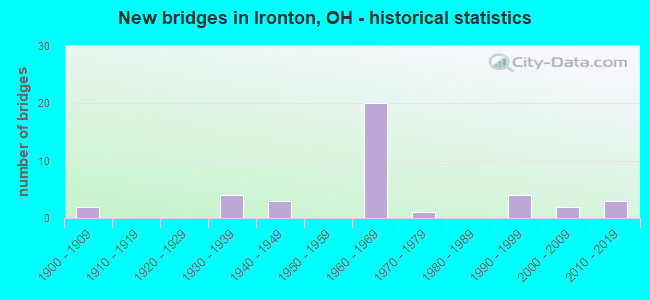
- New bridges - historical statistics
- 21900-1909
- 41930-1939
- 31940-1949
- 201960-1969
- 11970-1979
- 41990-1999
- 22000-2009
- 32010-2019
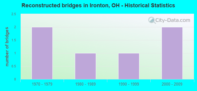
- Reconstructed bridges - Historical Statistics
- 21970-1979
- 11980-1989
- 11990-1999
- 22000-2009
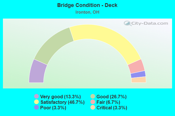
- Bridge Condition - Deck
- 13.3%Very good
- 26.7%Good
- 46.7%Satisfactory
- 6.7%Fair
- 3.3%Poor
- 3.3%Critical
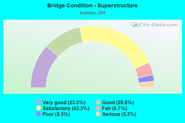
- Bridge Condition - Superstructure
- 23.3%Very good
- 20.0%Good
- 43.3%Satisfactory
- 6.7%Fair
- 3.3%Poor
- 3.3%Serious
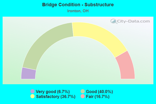
- Bridge Condition - Substructure
- 6.7%Very good
- 40.0%Good
- 36.7%Satisfactory
- 16.7%Fair
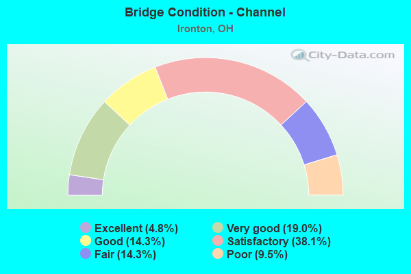
- Bridge Condition - Channel
- 4.8%Excellent
- 19.0%Very good
- 14.3%Good
- 38.1%Satisfactory
- 14.3%Fair
- 9.5%Poor
Find on map >> Show street view
Structure Number: 4400399, Location: 0.23MI W OF SR 93 (Lat: 38.541581, Lng: -82.680089), Route carried "on" structure: US 52, Year Built: 1960, Status: Open, Structure Length: 10.44m (34.25ft), Average Daily Traffic: 6,277 (year 2015), Truck Traffic: 11%, Average Future Daily Traffic: 8,712 (year 2035), Design Load: HS 20, Features Intersected: STORMS CK & LAWRENCE ST
Minimum Vertical Clearance: 30+ m (98+ ft), Kilometerpoint: 10.799, Lanes on structure: 2, Lanes under structure: 2, Base Highway Network: Yes, Owner: State Highway Agency, Approaching Roadway Width: 11.0m (36.1ft), Material/Design: Steel continuous, Design/Construction: Stringer/Multi-beam, Number Of Spans In Main Unit: 4, Length of Maximum Span: 28.7m (94.2ft), Curb-To-Curb Width: 9.2m (30.2ft), Out-to-Out Width: 11.2m (36.7ft)
Condition: Deck: Good, Superstructure: Very good, Substructure: Satisfactory, Channel: Satisfactory, Operating Rating: 42.1 metric tons, Method Used To Determine Operating Rating: Allowable Stress (AS) rating reported by rating factor (RF) method using MS18 loading, Inventory Rating: 32.4 metric tons, Method Used To Determine Inventory Rating: Allowable Stress (AS) rating reported by rating factor (RF) method using MS18 loading, Structural Evaluation: Equal to present minimum criteria, Deck Geometry: Meets minimum limits, Underclear: Superior to present desirable criteria, Waterway Adequacy: Equal to present desirable criteria, Approach Roadway Alignment: Equal to present desirable criteria, Designated Inspection Frequency: Every 12 months, Inspection Date: November 2021, Deck Structure Type: Concrete Cast-file-Place, Wearing Surface/Protective System: Wearing Surface: Integral Concrete
Find on map >> Show street view
Structure Number: 4400429, Location: 0.23MI W OF SR 93 (Lat: 38.541439, Lng: -82.680211), Route carried "on" structure: US 52, Year Built: 1960, Status: Open, Structure Length: 10.44m (34.25ft), Average Daily Traffic: 6,277 (year 2015), Truck Traffic: 11%, Average Future Daily Traffic: 8,712 (year 2035), Design Load: HS 20, Features Intersected: STORMS CK & LAWRENCE ST
Minimum Vertical Clearance: 30+ m (98+ ft), Kilometerpoint: 10.799, Lanes on structure: 2, Lanes under structure: 2, Base Highway Network: Yes, Owner: State Highway Agency, Approaching Roadway Width: 11.0m (36.1ft), Material/Design: Steel continuous, Design/Construction: Stringer/Multi-beam, Number Of Spans In Main Unit: 4, Length of Maximum Span: 28.7m (94.2ft), Curb-To-Curb Width: 9.2m (30.2ft), Out-to-Out Width: 11.2m (36.7ft)
Condition: Deck: Satisfactory, Superstructure: Good, Substructure: Satisfactory, Channel: Good, Operating Rating: 42.1 metric tons, Method Used To Determine Operating Rating: Allowable Stress (AS) rating reported by rating factor (RF) method using MS18 loading, Inventory Rating: 32.4 metric tons, Method Used To Determine Inventory Rating: Allowable Stress (AS) rating reported by rating factor (RF) method using MS18 loading, Structural Evaluation: Equal to present minimum criteria, Deck Geometry: Meets minimum limits, Underclear: Superior to present desirable criteria, Waterway Adequacy: Equal to present desirable criteria, Approach Roadway Alignment: Equal to present desirable criteria, Designated Inspection Frequency: Every 12 months, Inspection Date: November 2021, Deck Structure Type: Concrete Cast-file-Place, Wearing Surface/Protective System: Wearing Surface: Integral Concrete
Find on map >> Show street view
Structure Number: 4400453, Location: 0.12MI W OF SR 93 (Lat: 38.540319, Lng: -82.678661), Route carried "on" structure: US 52, Year Built: 1960, Status: Open, Structure Length: 4.24m (13.91ft), Average Daily Traffic: 6,277 (year 2015), Truck Traffic: 11%, Average Future Daily Traffic: 8,712 (year 2035), Design Load: HS 20, Features Intersected: ABANDONED RR
Minimum Vertical Clearance: 30+ m (98+ ft), Kilometerpoint: 10.976, Lanes on structure: 2, Base Highway Network: Yes, Owner: State Highway Agency, Approaching Roadway Width: 12.2m (40.0ft), Material/Design: Steel continuous, Design/Construction: Stringer/Multi-beam, Number Of Spans In Main Unit: 3, Length of Maximum Span: 14.9m (48.9ft), Curb-To-Curb Width: 13.6m (44.6ft), Out-to-Out Width: 14.9m (48.9ft)
Condition: Deck: Good, Superstructure: Good, Substructure: Good, Operating Rating: 55.1 metric tons, Method Used To Determine Operating Rating: Load and Resistance Factor Rating (LRFR) rating reported by rating factor(RF) method using HL-93 loadings, Inventory Rating: 42.1 metric tons, Method Used To Determine Inventory Rating: Load and Resistance Factor Rating (LRFR) rating reported by rating factor(RF) method using HL-93 loadings, Structural Evaluation: Better than present minimum criteria, Deck Geometry: Superior to present desirable criteria, Underclear: Superior to present desirable criteria, Approach Roadway Alignment: Equal to present desirable criteria, Designated Inspection Frequency: Every 24 months, Inspection Date: November 2021, Deck Structure Type: Concrete Cast-file-Place, Wearing Surface/Protective System: Wearing Surface: Bituminous
Find on map >> Show street view
Structure Number: 4400488, Location: 0.12MI W OF SR 93 (Lat: 38.540189, Lng: -82.678839), Route carried "on" structure: US 52, Year Built: 1960, Status: Open, Structure Length: 4.24m (13.91ft), Average Daily Traffic: 6,277 (year 2015), Truck Traffic: 11%, Average Future Daily Traffic: 8,712 (year 2035), Design Load: HS 20, Features Intersected: ABANDONED RR
Minimum Vertical Clearance: 30+ m (98+ ft), Kilometerpoint: 10.976, Lanes on structure: 2, Base Highway Network: Yes, Owner: State Highway Agency, Approaching Roadway Width: 12.2m (40.0ft), Material/Design: Steel continuous, Design/Construction: Stringer/Multi-beam, Number Of Spans In Main Unit: 3, Length of Maximum Span: 14.9m (48.9ft), Curb-To-Curb Width: 15.2m (49.9ft), Out-to-Out Width: 16.5m (54.1ft)
Condition: Deck: Satisfactory, Superstructure: Good, Substructure: Good, Operating Rating: 58.3 metric tons, Method Used To Determine Operating Rating: Load and Resistance Factor Rating (LRFR) rating reported by rating factor(RF) method using HL-93 loadings, Inventory Rating: 45.4 metric tons, Method Used To Determine Inventory Rating: Load and Resistance Factor Rating (LRFR) rating reported by rating factor(RF) method using HL-93 loadings, Structural Evaluation: Better than present minimum criteria, Deck Geometry: Superior to present desirable criteria, Underclear: Superior to present desirable criteria, Approach Roadway Alignment: Equal to present minimum criteria, Designated Inspection Frequency: Every 12 months, Inspection Date: November 2021, Deck Structure Type: Concrete Cast-file-Place, Wearing Surface/Protective System: Wearing Surface: Integral Concrete
Find on map >> Show street view
Structure Number: 4400518, Location: OVER SR 93 (Lat: 38.538989, Lng: -82.677119), Route carried "on" structure: US 52, Year Built: 1960, Status: Open, Structure Length: 5.49m (18.01ft), Average Daily Traffic: 7,691 (year 2015), Truck Traffic: 10%, Average Future Daily Traffic: 10,675 (year 2035), Design Load: HS 20, Features Intersected: STATE ROUTE 93
Minimum Vertical Clearance: 30+ m (98+ ft), Kilometerpoint: 11.169, Lanes on structure: 2, Lanes under structure: 4, Base Highway Network: Yes, Owner: State Highway Agency, Approaching Roadway Width: 14.6m (47.9ft), Material/Design: Steel continuous, Design/Construction: Stringer/Multi-beam, Number Of Spans In Main Unit: 3, Length of Maximum Span: 23.5m (77.1ft), Curb-To-Curb Width: 15.2m (49.9ft), Out-to-Out Width: 16.3m (53.5ft)
Condition: Deck: Satisfactory, Superstructure: Satisfactory, Substructure: Good, Operating Rating: 42.1 metric tons, Method Used To Determine Operating Rating: Allowable Stress (AS) rating reported by rating factor (RF) method using MS18 loading, Inventory Rating: 32.4 metric tons, Method Used To Determine Inventory Rating: Allowable Stress (AS) rating reported by rating factor (RF) method using MS18 loading, Structural Evaluation: Equal to present minimum criteria, Deck Geometry: Superior to present desirable criteria, Underclear: Meets minimum limits, Approach Roadway Alignment: Equal to present desirable criteria, Designated Inspection Frequency: Every 12 months, Inspection Date: November 2021, Deck Structure Type: Concrete Cast-file-Place, Wearing Surface/Protective System: Wearing Surface: Bituminous
Find on map >> Show street view
Structure Number: 4400542, Location: SR 93 (Lat: 38.538861, Lng: -82.677331), Route carried "on" structure: US 52, Year Built: 1962, Status: Open, Structure Length: 5.49m (18.01ft), Average Daily Traffic: 7,691 (year 2015), Truck Traffic: 10%, Average Future Daily Traffic: 10,675 (year 2035), Design Load: HS 20, Features Intersected: STATE ROUTE 93
Minimum Vertical Clearance: 30+ m (98+ ft), Kilometerpoint: 11.169, Lanes on structure: 2, Lanes under structure: 4, Base Highway Network: Yes, Owner: State Highway Agency, Approaching Roadway Width: 13.4m (44.0ft), Material/Design: Steel continuous, Design/Construction: Stringer/Multi-beam, Number Of Spans In Main Unit: 3, Length of Maximum Span: 23.5m (77.1ft), Curb-To-Curb Width: 11.5m (37.7ft), Out-to-Out Width: 12.8m (42.0ft)
Condition: Deck: Satisfactory, Superstructure: Good, Substructure: Good, Operating Rating: 42.1 metric tons, Method Used To Determine Operating Rating: Allowable Stress (AS) rating reported by rating factor (RF) method using MS18 loading, Inventory Rating: 32.4 metric tons, Method Used To Determine Inventory Rating: Allowable Stress (AS) rating reported by rating factor (RF) method using MS18 loading, Structural Evaluation: Better than present minimum criteria, Deck Geometry: Somewhat better than minimum adequacy, Underclear: Meets minimum limits, Approach Roadway Alignment: Equal to present desirable criteria, Designated Inspection Frequency: Every 12 months, Inspection Date: November 2021, Deck Structure Type: Concrete Cast-file-Place, Wearing Surface/Protective System: Wearing Surface: Bituminous
Find on map >> Show street view
Structure Number: 4400577, Location: OVER SR 141 (Lat: 38.526350, Lng: -82.664819), Route carried "on" structure: US 52, Year Built: 1962, Status: Open, Structure Length: 5.73m (18.80ft), Average Daily Traffic: 9,947 (year 2015), Truck Traffic: 8%, Average Future Daily Traffic: 13,806 (year 2035), Design Load: HS 20, Features Intersected: STATE ROUTE 141
Minimum Vertical Clearance: 30+ m (98+ ft), Kilometerpoint: 12.939, Lanes on structure: 2, Lanes under structure: 4, Base Highway Network: Yes, Owner: State Highway Agency, Approaching Roadway Width: 11.0m (36.1ft), Material/Design: Steel continuous, Design/Construction: Stringer/Multi-beam, Number Of Spans In Main Unit: 3, Length of Maximum Span: 22.6m (74.1ft), Curb-To-Curb Width: 11.5m (37.7ft), Out-to-Out Width: 12.8m (42.0ft)
Condition: Deck: Good, Superstructure: Satisfactory, Substructure: Good, Operating Rating: 42.1 metric tons, Method Used To Determine Operating Rating: Allowable Stress (AS) rating reported by rating factor (RF) method using MS18 loading, Inventory Rating: 32.4 metric tons, Method Used To Determine Inventory Rating: Allowable Stress (AS) rating reported by rating factor (RF) method using MS18 loading, Structural Evaluation: Equal to present minimum criteria, Deck Geometry: Somewhat better than minimum adequacy, Underclear: Meets minimum limits, Approach Roadway Alignment: Equal to present desirable criteria, Designated Inspection Frequency: Every 12 months, Inspection Date: November 2021, Deck Structure Type: Concrete Cast-file-Place, Wearing Surface/Protective System: Wearing Surface: Integral Concrete
Find on map >> Show street view
Structure Number: 4400607, Location: OVER SR 141 (Lat: 38.526239, Lng: -82.665011), Route carried "on" structure: US 52, Year Built: 1962, Status: Open, Structure Length: 5.73m (18.80ft), Average Daily Traffic: 9,947 (year 2015), Truck Traffic: 8%, Average Future Daily Traffic: 13,806 (year 2035), Design Load: HS 20, Features Intersected: STATE ROUTE 141
Minimum Vertical Clearance: 30+ m (98+ ft), Kilometerpoint: 12.939, Lanes on structure: 2, Lanes under structure: 4, Base Highway Network: Yes, Owner: State Highway Agency, Approaching Roadway Width: 11.0m (36.1ft), Material/Design: Steel continuous, Design/Construction: Stringer/Multi-beam, Number Of Spans In Main Unit: 3, Length of Maximum Span: 22.6m (74.1ft), Curb-To-Curb Width: 11.6m (38.1ft), Out-to-Out Width: 12.8m (42.0ft)
Condition: Deck: Satisfactory, Superstructure: Satisfactory, Substructure: Good, Operating Rating: 42.1 metric tons, Method Used To Determine Operating Rating: Allowable Stress (AS) rating reported by rating factor (RF) method using MS18 loading, Inventory Rating: 32.4 metric tons, Method Used To Determine Inventory Rating: Allowable Stress (AS) rating reported by rating factor (RF) method using MS18 loading, Structural Evaluation: Equal to present minimum criteria, Deck Geometry: Equal to present minimum criteria, Underclear: Meets minimum limits, Approach Roadway Alignment: Equal to present desirable criteria, Designated Inspection Frequency: Every 12 months, Inspection Date: November 2021, Deck Structure Type: Concrete Cast-file-Place, Wearing Surface/Protective System: Wearing Surface: Integral Concrete
Find on map >> Show street view
Structure Number: 4400631, Location: 0.95MI E OF SR 141 (Lat: 38.516261, Lng: -82.652669), Route carried "on" structure: US 52, Year Built: 1962, Status: Open, Structure Length: 7.50m (24.61ft), Average Daily Traffic: 10,788 (year 2015), Truck Traffic: 7%, Average Future Daily Traffic: 14,974 (year 2035), Design Load: HS 20, Features Intersected: ABAN RR,CR 24 MADDYVILLE
Minimum Vertical Clearance: 30+ m (98+ ft), Kilometerpoint: 14.468, Lanes on structure: 2, Lanes under structure: 2, Base Highway Network: Yes, Owner: State Highway Agency, Approaching Roadway Width: 12.2m (40.0ft), Skew: 1 degrees, Material/Design: Steel continuous, Design/Construction: Stringer/Multi-beam, Number Of Spans In Main Unit: 4, Length of Maximum Span: 21.9m (71.9ft), Curb-To-Curb Width: 9.1m (29.9ft), Out-to-Out Width: 11.4m (37.4ft)
Condition: Deck: Good, Superstructure: Satisfactory, Substructure: Fair, Operating Rating: 42.1 metric tons, Method Used To Determine Operating Rating: Allowable Stress (AS) rating reported by rating factor (RF) method using MS18 loading, Inventory Rating: 32.4 metric tons, Method Used To Determine Inventory Rating: Allowable Stress (AS) rating reported by rating factor (RF) method using MS18 loading, Structural Evaluation: Somewhat better than minimum adequacy, Deck Geometry: Meets minimum limits, Underclear: Superior to present desirable criteria, Approach Roadway Alignment: Equal to present desirable criteria, Designated Inspection Frequency: Every 12 months, Inspection Date: November 2021, Deck Structure Type: Concrete Cast-file-Place, Wearing Surface/Protective System: Wearing Surface: Integral Concrete
Find on map >> Show street view
Structure Number: 4400666, Location: 0.99 MI E OF SR 141 (Lat: 38.516350, Lng: -82.653031), Route carried "on" structure: US 52, Year Built: 1962, Status: Open, Structure Length: 7.50m (24.61ft), Average Daily Traffic: 10,788 (year 2015), Truck Traffic: 7%, Average Future Daily Traffic: 14,974 (year 2035), Design Load: HS 20, Features Intersected: ABAN RR,CR 24 MADDYVILLE
Minimum Vertical Clearance: 30+ m (98+ ft), Kilometerpoint: 14.468, Lanes on structure: 2, Lanes under structure: 2, Base Highway Network: Yes, Owner: State Highway Agency, Approaching Roadway Width: 12.2m (40.0ft), Skew: 1 degrees, Material/Design: Steel continuous, Design/Construction: Stringer/Multi-beam, Number Of Spans In Main Unit: 4, Length of Maximum Span: 21.9m (71.9ft), Curb-To-Curb Width: 9.1m (29.9ft), Out-to-Out Width: 11.3m (37.1ft)
Condition: Deck: Satisfactory, Superstructure: Satisfactory, Substructure: Satisfactory, Operating Rating: 42.1 metric tons, Method Used To Determine Operating Rating: Allowable Stress (AS) rating reported by rating factor (RF) method using MS18 loading, Inventory Rating: 32.4 metric tons, Method Used To Determine Inventory Rating: Allowable Stress (AS) rating reported by rating factor (RF) method using MS18 loading, Structural Evaluation: Equal to present minimum criteria, Deck Geometry: Meets minimum limits, Underclear: Superior to present desirable criteria, Approach Roadway Alignment: Equal to present desirable criteria, Designated Inspection Frequency: Every 12 months, Inspection Date: November 2021, Deck Structure Type: Concrete Cast-file-Place, Wearing Surface/Protective System: Wearing Surface: Integral Concrete
Find on map >> Show street view
Structure Number: 440069, Location: 0.87MI W OF SR 243 (Lat: 38.514731, Lng: -82.651900), Route carried "on" structure: US 52, Year Built: 1962, Status: Open, Structure Length: 11.19m (36.71ft), Average Daily Traffic: 10,788 (year 2015), Truck Traffic: 7%, Average Future Daily Traffic: 14,974 (year 2035), Design Load: HS 20, Features Intersected: ICE CREEK
Minimum Vertical Clearance: 30+ m (98+ ft), Kilometerpoint: 14.677, Lanes on structure: 2, Base Highway Network: Yes, Owner: State Highway Agency, Approaching Roadway Width: 12.2m (40.0ft), Skew: 3 degrees, Material/Design: Steel continuous, Design/Construction: Stringer/Multi-beam, Number Of Spans In Main Unit: 3, Length of Maximum Span: 41.5m (136.2ft), Curb-To-Curb Width: 9.3m (30.5ft), Out-to-Out Width: 11.2m (36.7ft)
Condition: Deck: Good, Superstructure: Good, Substructure: Satisfactory, Channel: Very good, Operating Rating: 35.6 metric tons, Method Used To Determine Operating Rating: Load and Resistance Factor Rating (LRFR) rating reported by rating factor(RF) method using HL-93 loadings, Inventory Rating: 25.9 metric tons, Method Used To Determine Inventory Rating: Load and Resistance Factor Rating (LRFR) rating reported by rating factor(RF) method using HL-93 loadings, Structural Evaluation: Equal to present minimum criteria, Deck Geometry: Meets minimum limits, Waterway Adequacy: Equal to present desirable criteria, Approach Roadway Alignment: Equal to present desirable criteria, Designated Inspection Frequency: Every 12 months, Inspection Date: November 2021, Deck Structure Type: Concrete Cast-file-Place, Wearing Surface/Protective System: Wearing Surface: Integral Concrete
Find on map >> Show street view
Structure Number: 440072, Location: 0.87 MI W OF SR 243 (Lat: 38.514611, Lng: -82.652081), Route carried "on" structure: US 52, Year Built: 1962, Status: Open, Structure Length: 11.19m (36.71ft), Average Daily Traffic: 10,788 (year 2015), Truck Traffic: 7%, Average Future Daily Traffic: 14,974 (year 2035), Design Load: HS 20, Features Intersected: ICE CREEK
Minimum Vertical Clearance: 30+ m (98+ ft), Kilometerpoint: 14.677, Lanes on structure: 2, Base Highway Network: Yes, Owner: State Highway Agency, Approaching Roadway Width: 12.2m (40.0ft), Skew: 3 degrees, Material/Design: Steel continuous, Design/Construction: Stringer/Multi-beam, Number Of Spans In Main Unit: 3, Length of Maximum Span: 41.5m (136.2ft), Curb-To-Curb Width: 9.1m (29.9ft), Out-to-Out Width: 11.2m (36.7ft)
Condition: Deck: Good, Superstructure: Satisfactory, Substructure: Satisfactory, Channel: Very good, Operating Rating: 42.1 metric tons, Method Used To Determine Operating Rating: Allowable Stress (AS) rating reported by rating factor (RF) method using MS18 loading, Inventory Rating: 32.4 metric tons, Method Used To Determine Inventory Rating: Allowable Stress (AS) rating reported by rating factor (RF) method using MS18 loading, Structural Evaluation: Equal to present minimum criteria, Deck Geometry: Meets minimum limits, Waterway Adequacy: Equal to present desirable criteria, Approach Roadway Alignment: Equal to present desirable criteria, Designated Inspection Frequency: Every 12 months, Inspection Date: November 2021, Deck Structure Type: Concrete Cast-file-Place, Wearing Surface/Protective System: Wearing Surface: Integral Concrete
Find on map >> Show street view
Structure Number: 4401263, Location: 2ND ST BETWN ADAMS /JEFF (Lat: 38.527211, Lng: -82.683481), Route carried "on" structure: State highway 93, Year Built: 2016, Status: Open, Structure Length: 79.75m (261.65ft), Average Daily Traffic: 10,300 (year 2008), Truck Traffic: 4%, Average Future Daily Traffic: 14,430 (year 2028), Design Load: HL 93, Features Intersected: OHIO RIVER
Minimum Vertical Clearance: 30+ m (98+ ft), Kilometerpoint: 0.002, Lanes on structure: 2, Lanes under structure: 2, Owner: State Highway Agency, Approaching Roadway Width: 14.8m (48.6ft), Navigation Control: Yes ( Vertical Clearance: 27.4m (89.9ft), Horizontal Clearance: 245.4m (805.1ft)), Material/Design: Steel, Design/Construction: Stayed Girder, Number Of Spans In Main Unit: 3, Number Of Approach Spans: 6, Length of Maximum Span: 274.3m (899.9ft), Curb-To-Curb Width: 9.8m (32.2ft), Out-to-Out Width: 13.1m (43.0ft)
Condition: Deck: Very good, Superstructure: Very good, Substructure: Good, Channel: Excellent, Operating Rating: 36.0 metric tons, Method Used To Determine Operating Rating: Load and Resistance Factor Rating (LRFR) rating reported by rating factor(RF) method using HL-93 loadings, Inventory Rating: 32.7 metric tons, Method Used To Determine Inventory Rating: Load and Resistance Factor Rating (LRFR) rating reported by rating factor(RF) method using HL-93 loadings, Structural Evaluation: Better than present minimum criteria, Deck Geometry: Meets minimum limits, Underclear: Superior to present desirable criteria, Waterway Adequacy: Superior to present desirable criteria, Approach Roadway Alignment: Equal to present desirable criteria, Designated Inspection Frequency: Every 24 months, Underwater Inspection Frequency: Every 60 months, Inspection Date: September 2021, Underwater Inspection Date: July 2019, Deck Structure Type: Concrete Cast-file-Place, Wearing Surface/Protective System: Wearing Surface: Integral Concrete, Deck Protection: Epoxy Coated Reinforcing
Find on map >> Show street view
Structure Number: 440136, Location: 5.13 MI N OF US RT 52 (Lat: 38.575681, Lng: -82.635889), Route carried "on" structure: State highway 93, Year Built: 1994, Status: Open, Structure Length: 0.72m (2.36ft), Average Daily Traffic: 6,544 (year 2015), Truck Traffic: 21%, Average Future Daily Traffic: 9,083 (year 2035), Design Load: HS 20+Mod, Features Intersected: NORRIS BR OF STORMS CREE
Minimum Vertical Clearance: 30+ m (98+ ft), Kilometerpoint: 6.293, Lanes on structure: 2, Base Highway Network: Yes, Owner: State Highway Agency, Approaching Roadway Width: 12.2m (40.0ft), Skew: 3 degrees, Material/Design: Concrete, Design/Construction: Frame, Number Of Spans In Main Unit: 1, Length of Maximum Span: 6.7m (22.0ft), Curb-To-Curb Width: 12.8m (42.0ft), Out-to-Out Width: 12.8m (42.0ft)
Condition: Deck: Satisfactory, Superstructure: Satisfactory, Substructure: Satisfactory, Channel: Satisfactory, Operating Rating: 68.0 metric tons, Method Used To Determine Operating Rating: Load Factor (LF) rating reported by rating factor (RF) method using MS18 loading, Inventory Rating: 42.1 metric tons, Method Used To Determine Inventory Rating: Load Factor (LF) rating reported by rating factor (RF) method using MS18 loading, Structural Evaluation: Equal to present minimum criteria, Deck Geometry: Somewhat better than minimum adequacy, Waterway Adequacy: Equal to present desirable criteria, Approach Roadway Alignment: Equal to present minimum criteria, Designated Inspection Frequency: Every 12 months, Inspection Date: June 2021, Deck Structure Type: Concrete Cast-file-Place, Wearing Surface/Protective System: Wearing Surface: Bituminous, Membrane: Preformed Fabric
Find on map >> Show street view
Structure Number: 4401395, Location: 8.56 KM N OF US 52 (Lat: 38.577869, Lng: -82.637511), Route carried "on" structure: State highway 93, Year Built: 1995, Status: Open, Structure Length: 3.05m (10.01ft), Average Daily Traffic: 6,544 (year 2015), Truck Traffic: 21%, Average Future Daily Traffic: 9,083 (year 2035), Design Load: HS 20+Mod, Features Intersected: STORMS CREEK
Minimum Vertical Clearance: 30+ m (98+ ft), Kilometerpoint: 6.598, Lanes on structure: 2, Base Highway Network: Yes, Owner: State Highway Agency, Approaching Roadway Width: 11.6m (38.1ft), Skew: 4 degrees, Material/Design: Prestressed concrete, Design/Construction: Stringer/Multi-beam, Number Of Spans In Main Unit: 1, Length of Maximum Span: 28.0m (91.9ft), Curb-To-Curb Width: 11.6m (38.1ft), Out-to-Out Width: 11.6m (38.1ft)
Condition: Deck: Satisfactory, Superstructure: Good, Substructure: Good, Channel: Good, Operating Rating: 42.1 metric tons, Method Used To Determine Operating Rating: Load Factor (LF) rating reported by rating factor (RF) method using MS18 loading, Inventory Rating: 32.4 metric tons, Method Used To Determine Inventory Rating: Load Factor (LF) rating reported by rating factor (RF) method using MS18 loading, Structural Evaluation: Better than present minimum criteria, Deck Geometry: Somewhat better than minimum adequacy, Waterway Adequacy: Equal to present desirable criteria, Approach Roadway Alignment: Equal to present minimum criteria, Designated Inspection Frequency: Every 12 months, Inspection Date: June 2021, Deck Structure Type: Concrete Cast-file-Place, Wearing Surface/Protective System: Wearing Surface: Monolithic Concrete, Deck Protection: Epoxy Coated Reinforcing
Find on map >> Show street view
Structure Number: 4432223, Location: .18 MI N OF IRONTON CORP (Lat: 38.541311, Lng: -82.679450), Route carried "on" structure: County highway C0022, Year Built: 2013, Status: Open, Structure Length: 3.08m (10.10ft), Average Daily Traffic: 1,219 (year 2015), Truck Traffic: 2%, Average Future Daily Traffic: 1,692 (year 2038), Design Load: HL 93, Features Intersected: STORMS CREEK, Facility Carried by Structure: COUNTY ROAD 22
Minimum Vertical Clearance: 30+ m (98+ ft), Kilometerpoint: 0.290, Lanes on structure: 2, Owner: County Highway Agency, Approaching Roadway Width: 8.5m (27.9ft), Skew: 3 degrees, Material/Design: Prestressed concrete, Design/Construction: Box Beam or Girders - Multiple, Number Of Spans In Main Unit: 1, Length of Maximum Span: 29.8m (97.8ft), Curb-To-Curb Width: 8.5m (27.9ft), Out-to-Out Width: 8.5m (27.9ft)
Condition: Deck: Very good, Superstructure: Very good, Substructure: Very good, Channel: Very good, Operating Rating: 74.5 metric tons, Method Used To Determine Operating Rating: Load and Resistance Factor Rating (LRFR) rating reported by rating factor(RF) method using HL-93 loadings, Inventory Rating: 38.9 metric tons, Method Used To Determine Inventory Rating: Load and Resistance Factor Rating (LRFR) rating reported by rating factor(RF) method using HL-93 loadings, Structural Evaluation: Equal to present desirable criteria, Deck Geometry: Somewhat better than minimum adequacy, Waterway Adequacy: Equal to present minimum criteria, Approach Roadway Alignment: Equal to present minimum criteria, Designated Inspection Frequency: Every 24 months, Inspection Date: January 2022, Deck Structure Type: Concrete Cast-file-Place, Wearing Surface/Protective System: Wearing Surface: Monolithic Concrete, Deck Protection: Epoxy Coated Reinforcing
Find on map >> Show street view
Structure Number: 4435567, Location: 0.27 MILES WEST OF SR 93 (Lat: 38.548831, Lng: -82.662361), Route carried "on" structure: County highway C0021, Year Built: 1949, Year Reconstructed: 2007, Status: Open, Structure Length: 1.89m (6.20ft), Average Daily Traffic: 906 (year 2015), Truck Traffic: 8%, Average Future Daily Traffic: 1,258 (year 2035), Design Load: HS 20, Features Intersected: STORMS CREEK, Facility Carried by Structure: PORTER GAP ROAD
Minimum Vertical Clearance: 30+ m (98+ ft), Kilometerpoint: 0.435, Lanes on structure: 2, Owner: County Highway Agency, Approaching Roadway Width: 6.1m (20.0ft), Material/Design: Steel, Design/Construction: Stringer/Multi-beam, Number Of Spans In Main Unit: 1, Length of Maximum Span: 17.7m (58.1ft), Curb-To-Curb Width: 7.3m (24.0ft), Out-to-Out Width: 7.3m (24.0ft)
Condition: Deck: Satisfactory, Superstructure: Very good, Substructure: Satisfactory, Channel: Satisfactory, Operating Rating: 61.6 metric tons, Method Used To Determine Operating Rating: Allowable Stress (AS) rating reported by rating factor (RF) method using MS18 loading, Inventory Rating: 42.1 metric tons, Method Used To Determine Inventory Rating: Allowable Stress (AS) rating reported by rating factor (RF) method using MS18 loading, Structural Evaluation: Equal to present minimum criteria, Deck Geometry: Meets minimum limits, Waterway Adequacy: Equal to present desirable criteria, Approach Roadway Alignment: Equal to present desirable criteria, Designated Inspection Frequency: Every 12 months, Inspection Date: April 2020, Deck Structure Type: Corrugated Steel, Wearing Surface/Protective System: Wearing Surface: Bituminous
Find on map >> Show street view
Structure Number: 4435656, Location: 315 FT S OF CTY RD 22 (Lat: 38.570939, Lng: -82.678311), Route carried "on" structure: County highway C0021, Year Built: 2006, Status: Posted for load, Structure Length: 0.98m (3.22ft), Average Daily Traffic: 906 (year 2015), Truck Traffic: 8%, Average Future Daily Traffic: 1,258 (year 2035), Design Load: HS 20, Features Intersected: LITTLE STORMS CREEK, Facility Carried by Structure: PORTER GAP ROAD
Minimum Vertical Clearance: 30+ m (98+ ft), Kilometerpoint: 3.347, Lanes on structure: 2, Owner: County Highway Agency, Approaching Roadway Width: 6.4m (21.0ft), Skew: 1 degrees, Material/Design: Steel, Design/Construction: Stringer/Multi-beam, Number Of Spans In Main Unit: 1, Length of Maximum Span: 9.1m (29.9ft), Curb-To-Curb Width: 7.2m (23.6ft), Out-to-Out Width: 7.2m (23.6ft)
Condition: Deck: Fair, Superstructure: Fair, Substructure: Good, Channel: Fair, Operating Rating: 35.6 metric tons, Method Used To Determine Operating Rating: Allowable Stress (AS) rating reported by rating factor (RF) method using MS18 loading, Inventory Rating: 22.7 metric tons, Method Used To Determine Inventory Rating: Allowable Stress (AS) rating reported by rating factor (RF) method using MS18 loading, Structural Evaluation: Somewhat better than minimum adequacy, Deck Geometry: Meets minimum limits, Waterway Adequacy: Equal to present minimum criteria, Approach Roadway Alignment: Somewhat better than minimum adequacy, Bridge Posting: Required (Relationship of Operating Rating to Maximum Legal Load: 10.0 - 19.9% below), Designated Inspection Frequency: Every 12 months, Inspection Date: December 2021, Deck Structure Type: Corrugated Steel, Wearing Surface/Protective System: Wearing Surface: Bituminous
Find on map >> Show street view
Structure Number: 4435753, Location: 1.10 MILES NORTH OF C0RP (Lat: 38.552061, Lng: -82.675711), Route carried "on" structure: County highway C0022, Year Built: 1900, Year Reconstructed: 2005, Status: Open, Structure Length: 1.31m (4.30ft), Average Daily Traffic: 1,219 (year 2015), Truck Traffic: 2%, Average Future Daily Traffic: 1,692 (year 2035), Design Load: HS 20, Features Intersected: LITTLE STORMS CREEK, Facility Carried by Structure: COUNTY ROAD 22
Minimum Vertical Clearance: 30+ m (98+ ft), Kilometerpoint: 1.770, Lanes on structure: 2, Owner: County Highway Agency, Approaching Roadway Width: 6.4m (21.0ft), Skew: 1 degrees, Material/Design: Steel, Design/Construction: Stringer/Multi-beam, Number Of Spans In Main Unit: 1, Length of Maximum Span: 12.2m (40.0ft), Curb-To-Curb Width: 7.3m (24.0ft), Out-to-Out Width: 7.3m (24.0ft)
Condition: Deck: Satisfactory, Superstructure: Very good, Substructure: Good, Channel: Satisfactory, Operating Rating: 55.1 metric tons, Method Used To Determine Operating Rating: Allowable Stress (AS) rating reported by rating factor (RF) method using MS18 loading, Inventory Rating: 38.9 metric tons, Method Used To Determine Inventory Rating: Allowable Stress (AS) rating reported by rating factor (RF) method using MS18 loading, Structural Evaluation: Better than present minimum criteria, Deck Geometry: Meets minimum limits, Waterway Adequacy: Equal to present minimum criteria, Approach Roadway Alignment: Somewhat better than minimum adequacy, Length Of Structure Improvement: 7.62m (25.00ft), Designated Inspection Frequency: Every 12 months, Inspection Date: December 2021, Bridge Improvement Cost: $95,000, Roadway Improvement Cost: $5,000, Total Project Cost: $100,000, Deck Structure Type: Corrugated Steel, Wearing Surface/Protective System: Wearing Surface: Bituminous
Find on map >> Show street view
Structure Number: 4435796, Location: 20 FT N OF TWP RD 203E (Lat: 38.558600, Lng: -82.686769), Route carried "on" structure: County highway C0022, Year Built: 1935, Status: Open, Structure Length: 1.19m (3.90ft), Average Daily Traffic: 246 (year 2015), Truck Traffic: 7%, Average Future Daily Traffic: 341 (year 2035), Design Load: H 15, Features Intersected: LITTLE STORMS CREEK, Facility Carried by Structure: COUNTY ROAD 22
Minimum Vertical Clearance: 30+ m (98+ ft), Kilometerpoint: 3.187, Lanes on structure: 1, Owner: County Highway Agency, Approaching Roadway Width: 5.5m (18.0ft), Skew: 3 degrees, Material/Design: Concrete, Design/Construction: Slab, Number Of Spans In Main Unit: 1, Length of Maximum Span: 11.3m (37.1ft), Curb-To-Curb Width: 4.9m (16.1ft), Out-to-Out Width: 5.6m (18.4ft)
Condition: Deck: Poor, Superstructure: Poor, Substructure: Fair, Channel: Fair, Operating Rating: 64.8 metric tons, Method Used To Determine Operating Rating: Load Factor (LF) rating reported by rating factor (RF) method using MS18 loading, Inventory Rating: 38.9 metric tons, Method Used To Determine Inventory Rating: Load Factor (LF) rating reported by rating factor (RF) method using MS18 loading, Structural Evaluation: Meets minimum limits, Deck Geometry: High priority of replacement, Waterway Adequacy: Somewhat better than minimum adequacy, Approach Roadway Alignment: Somewhat better than minimum adequacy, Length Of Structure Improvement: 7.32m (24.02ft), Designated Inspection Frequency: Every 12 months, Inspection Date: December 2021, Bridge Improvement Cost: $22,000, Roadway Improvement Cost: $2,000, Total Project Cost: $43,000, Deck Structure Type: Concrete Cast-file-Place, Wearing Surface/Protective System: Wearing Surface: Bituminous
Find on map >> Show street view
Structure Number: 4435974, Location: 65 FT E OF CTY RD 181 (Lat: 38.514761, Lng: -82.650050), Route carried "on" structure: County highway C0024, Year Built: 1978, Status: Open, Structure Length: 5.73m (18.80ft), Average Daily Traffic: 1,350 (year 2015), Truck Traffic: 5%, Average Future Daily Traffic: 1,874 (year 2035), Design Load: H 15, Features Intersected: BIG ICE CREEK, Facility Carried by Structure: MADDYVILLE TPKA
Minimum Vertical Clearance: 30+ m (98+ ft), Kilometerpoint: 0.386, Lanes on structure: 2, Owner: County Highway Agency, Approaching Roadway Width: 7.3m (24.0ft), Material/Design: Prestressed concrete continuous, Design/Construction: Box Beam or Girders - Multiple, Number Of Spans In Main Unit: 3, Length of Maximum Span: 21.3m (69.9ft), Curb-To-Curb Width: 11.1m (36.4ft), Out-to-Out Width: 11.1m (36.4ft)
Condition: Deck: Satisfactory, Superstructure: Satisfactory, Substructure: Good, Channel: Good, Operating Rating: 71.3 metric tons, Method Used To Determine Operating Rating: Load Factor (LF) rating reported by rating factor (RF) method using MS18 loading, Inventory Rating: 42.1 metric tons, Method Used To Determine Inventory Rating: Load Factor (LF) rating reported by rating factor (RF) method using MS18 loading, Structural Evaluation: Equal to present minimum criteria, Deck Geometry: Equal to present minimum criteria, Waterway Adequacy: Equal to present desirable criteria, Approach Roadway Alignment: Equal to present desirable criteria, Designated Inspection Frequency: Every 12 months, Inspection Date: December 2021, Deck Structure Type: Concrete Cast-file-Place, Wearing Surface/Protective System: Wearing Surface: Bituminous
Find on map >> Show street view
Structure Number: 4439996, Location: 0.61 MI E OF SR 141 (Lat: 38.539569, Lng: -82.619811), Route carried "on" structure: County highway C0052, Year Built: 1993, Status: Open, Structure Length: 0.85m (2.79ft), Average Daily Traffic: 127 (year 2015), Truck Traffic: 8%, Average Future Daily Traffic: 176 (year 2038), Design Load: HS 20, Features Intersected: SUGAR CREEK, Facility Carried by Structure: COUNTY ROAD 52
Minimum Vertical Clearance: 30+ m (98+ ft), Kilometerpoint: 0.982, Lanes on structure: 2, Owner: County Highway Agency, Approaching Roadway Width: 6.1m (20.0ft), Skew: 2 degrees, Material/Design: Concrete, Design/Construction: Tee Beam, Number Of Spans In Main Unit: 1, Length of Maximum Span: 7.6m (24.9ft), Curb-To-Curb Width: 6.5m (21.3ft), Out-to-Out Width: 6.5m (21.3ft)
Condition: Deck: Satisfactory, Superstructure: Satisfactory, Substructure: Satisfactory, Channel: Poor, Operating Rating: 97.2 metric tons, Method Used To Determine Operating Rating: Load Factor (LF) rating reported by rating factor (RF) method using MS18 loading, Inventory Rating: 90.7 metric tons, Method Used To Determine Inventory Rating: Load Factor (LF) rating reported by rating factor (RF) method using MS18 loading, Structural Evaluation: Equal to present minimum criteria, Deck Geometry: Meets minimum limits, Waterway Adequacy: Equal to present minimum criteria, Approach Roadway Alignment: Equal to present minimum criteria, Designated Inspection Frequency: Every 12 months, Inspection Date: December 2021, Deck Structure Type: Concrete Cast-file-Place, Wearing Surface/Protective System: Wearing Surface: Bituminous
Find on map >> Show street view
Structure Number: 4451929, Location: 0.12 MILES NORTH OF CR 21 (Lat: 38.573200, Lng: -82.680000), Route carried "on" structure: County highway T0179, Year Built: 1938, Status: Posted for load, Structure Length: 0.76m (2.49ft), Average Daily Traffic: 215 (year 2015), Truck Traffic: 7%, Average Future Daily Traffic: 298 (year 2035), Features Intersected: LITTLE STORMS CREEK, Facility Carried by Structure: TOWNSHIP ROAD 179
Minimum Vertical Clearance: 30+ m (98+ ft), Kilometerpoint: 0.193, Lanes on structure: 2, Owner: County Highway Agency, Approaching Roadway Width: 5.8m (19.0ft), Skew: 3 degrees, Material/Design: Concrete, Design/Construction: Slab, Number Of Spans In Main Unit: 1, Length of Maximum Span: 7.0m (23.0ft), Curb-To-Curb Width: 6.1m (20.0ft), Out-to-Out Width: 7.2m (23.6ft)
Condition: Deck: Fair, Superstructure: Fair, Substructure: Fair, Channel: Poor, Operating Rating: 19.4 metric tons, Method Used To Determine Operating Rating: Load Factor (LF) rating reported by rating factor (RF) method using MS18 loading, Inventory Rating: 13.0 metric tons, Method Used To Determine Inventory Rating: Load Factor (LF) rating reported by rating factor (RF) method using MS18 loading, Structural Evaluation: Meets minimum limits, Deck Geometry: Meets minimum limits, Waterway Adequacy: Equal to present minimum criteria, Approach Roadway Alignment: Somewhat better than minimum adequacy, Bridge Posting: Required (Relationship of Operating Rating to Maximum Legal Load: > 39.9% below), Designated Inspection Frequency: Every 12 months, Inspection Date: December 2021, Deck Structure Type: Concrete Cast-file-Place, Wearing Surface/Protective System: Wearing Surface: Bituminous
Find on map >> Show street view
Structure Number: 4451953, Location: 0.61 MILES NORTH OF CR 22 (Lat: 38.576969, Lng: -82.675669), Route carried "on" structure: County highway T0179, Year Built: 1940, Status: Open, Structure Length: 0.85m (2.79ft), Average Daily Traffic: 215 (year 2015), Truck Traffic: 7%, Average Future Daily Traffic: 298 (year 2035), Features Intersected: LITTLE STORMS CREEK, Facility Carried by Structure: TOWNSHIP ROAD 179
Minimum Vertical Clearance: 30+ m (98+ ft), Kilometerpoint: 0.982, Lanes on structure: 2, Owner: County Highway Agency, Approaching Roadway Width: 7.3m (24.0ft), Skew: 4 degrees, Material/Design: Concrete, Design/Construction: Slab, Number Of Spans In Main Unit: 1, Length of Maximum Span: 7.6m (24.9ft), Curb or Sidewalk Widths: Left: 0.2m (0.7ft), Right: 0.2m (0.7ft), Curb-To-Curb Width: 6.4m (21.0ft), Out-to-Out Width: 7.2m (23.6ft)
Condition: Deck: Satisfactory, Superstructure: Satisfactory, Substructure: Fair, Channel: Fair, Operating Rating: 42.1 metric tons, Method Used To Determine Operating Rating: Load Factor (LF) rating reported by rating factor (RF) method using MS18 loading, Inventory Rating: 25.9 metric tons, Method Used To Determine Inventory Rating: Load Factor (LF) rating reported by rating factor (RF) method using MS18 loading, Structural Evaluation: Somewhat better than minimum adequacy, Deck Geometry: Meets minimum limits, Waterway Adequacy: Equal to present minimum criteria, Approach Roadway Alignment: Somewhat better than minimum adequacy, Length Of Structure Improvement: 7.01m (23.00ft), Designated Inspection Frequency: Every 12 months, Inspection Date: December 2021, Bridge Improvement Cost: $14,000, Roadway Improvement Cost: $1,000, Total Project Cost: $34,000, Deck Structure Type: Concrete Cast-file-Place, Wearing Surface/Protective System: Wearing Surface: Bituminous
Find on map >> Show street view
Structure Number: 4458508, Location: 250 FT W OF TWP RD 179 (Lat: 38.582131, Lng: -82.675619), Route carried "on" structure: County highway T0271, Year Built: 1997, Status: Open, Structure Length: 0.79m (2.59ft), Average Daily Traffic: 96 (year 2015), Truck Traffic: 7%, Average Future Daily Traffic: 133 (year 2038), Design Load: HS 20, Features Intersected: TRIB OF STORMS CREEK, Facility Carried by Structure: TOWNSHIP ROAD 271
Minimum Vertical Clearance: 30+ m (98+ ft), Kilometerpoint: 0.467, Lanes on structure: 1, Owner: County Highway Agency, Approaching Roadway Width: 3.4m (11.2ft), Material/Design: Concrete, Design/Construction: Tee Beam, Number Of Spans In Main Unit: 1, Length of Maximum Span: 6.4m (21.0ft), Curb-To-Curb Width: 6.5m (21.3ft), Out-to-Out Width: 6.5m (21.3ft)
Condition: Deck: Very good, Superstructure: Very good, Substructure: Very good, Channel: Satisfactory, Operating Rating: 97.2 metric tons, Method Used To Determine Operating Rating: Load Factor (LF) rating reported by rating factor (RF) method using MS18 loading, Inventory Rating: 84.2 metric tons, Method Used To Determine Inventory Rating: Load Factor (LF) rating reported by rating factor (RF) method using MS18 loading, Structural Evaluation: Equal to present desirable criteria, Deck Geometry: Somewhat better than minimum adequacy, Waterway Adequacy: Equal to present desirable criteria, Approach Roadway Alignment: Equal to present minimum criteria, Designated Inspection Frequency: Every 24 months, Inspection Date: March 2020, Deck Structure Type: Concrete Cast-file-Place, Wearing Surface/Protective System: Wearing Surface: Bituminous
Find on map >> Show street view
Structure Number: 4460006, Location: 266' N OF MARION PIKE (Lat: 38.499161, Lng: -82.654669), Route carried "on" structure: City street 3RDST, Year Built: 1943, Year Reconstructed: 1987, Status: Posted for load, Structure Length: 5.61m (18.41ft), Average Daily Traffic: 7,071 (year 2018), Truck Traffic: 6%, Average Future Daily Traffic: 11,241 (year 2038), Design Load: HS 15, Features Intersected: ICE CREEK, Facility Carried by Structure: 3RD STREET
Minimum Vertical Clearance: 30+ m (98+ ft), Kilometerpoint: 0.000, Lanes on structure: 2, Owner: City or Municipal Highway Agency, Approaching Roadway Width: 11.0m (36.1ft), Material/Design: Concrete continuous, Design/Construction: Tee Beam, Number Of Spans In Main Unit: 3, Length of Maximum Span: 22.6m (74.1ft), Curb or Sidewalk Widths: Left: 0.0m, Right: 1.8m (5.9ft), Curb-To-Curb Width: 15.9m (52.2ft), Out-to-Out Width: 18.5m (60.7ft)
Condition: Deck: Good, Superstructure: Satisfactory, Substructure: Satisfactory, Channel: Satisfactory, Operating Rating: 29.2 metric tons, Method Used To Determine Operating Rating: Load Factor (LF) rating reported by rating factor (RF) method using MS18 loading, Inventory Rating: 16.2 metric tons, Method Used To Determine Inventory Rating: Load Factor (LF) rating reported by rating factor (RF) method using MS18 loading, Structural Evaluation: Meets minimum limits, Deck Geometry: Superior to present desirable criteria, Waterway Adequacy: Superior to present desirable criteria, Approach Roadway Alignment: Equal to present desirable criteria, Bridge Posting: Required (Relationship of Operating Rating to Maximum Legal Load: 20.0 - 29.9% below), Designated Inspection Frequency: Every 12 months, Inspection Date: July 2021, Deck Structure Type: Concrete Cast-file-Place, Wearing Surface/Protective System: Wearing Surface: Monolithic Concrete, Deck Protection: Epoxy Coated Reinforcing
Find on map >> Show street view
Structure Number: 4460014, Location: 0.3 MI N JCT RAILROAD ST (Lat: 38.539931, Lng: -82.690461), Route carried "on" structure: City street 2NDST, Year Built: 1936, Year Reconstructed: 1995, Status: Open, Structure Length: 14.68m (48.16ft), Average Daily Traffic: 4,781 (year 2018), Truck Traffic: 3%, Average Future Daily Traffic: 2,800 (year 2038), Design Load: H 15, Features Intersected: N & W RAILROAD, Facility Carried by Structure: NORTH 2ND STREET
Minimum Vertical Clearance: 30+ m (98+ ft), Kilometerpoint: 5.391, Lanes on structure: 2, Owner: City or Municipal Highway Agency, Approaching Roadway Width: 12.2m (40.0ft), Skew: 2 degrees, Material/Design: Steel, Design/Construction: Truss - Deck, Number Of Spans In Main Unit: 1, Number Of Approach Spans: 5, Length of Maximum Span: 44.7m (146.7ft), Curb or Sidewalk Widths: Left: 1.3m (4.3ft), Right: 1.3m (4.3ft), Curb-To-Curb Width: 12.2m (40.0ft), Out-to-Out Width: 15.5m (50.9ft)
Condition: Deck: Good, Superstructure: Satisfactory, Substructure: Satisfactory, Operating Rating: 42.1 metric tons, Method Used To Determine Operating Rating: Load Factor (LF) rating reported by rating factor (RF) method using MS18 loading, Inventory Rating: 25.9 metric tons, Method Used To Determine Inventory Rating: Load Factor (LF) rating reported by rating factor (RF) method using MS18 loading, Structural Evaluation: Equal to present minimum criteria, Deck Geometry: Equal to present minimum criteria, Underclear: Meets minimum limits, Approach Roadway Alignment: Equal to present desirable criteria, Designated Inspection Frequency: Every 12 months, Critical Feature Inspection Frequency: Every 24 months, Inspection Date: July 2021, Critical Feature Inspection Date: July 2020, Deck Structure Type: Concrete Cast-file-Place, Wearing Surface/Protective System: Wearing Surface: Monolithic Concrete
Find on map >> Show street view
Structure Number: 4460022, Location: 390' S OF SYCAMORE ST (Lat: 38.545281, Lng: -82.697669), Route carried "on" structure: City street 2NDST, Year Built: 1939, Year Reconstructed: 1978, Status: Posted for load, Structure Length: 4.69m (15.39ft), Average Daily Traffic: 1,800 (year 2018), Truck Traffic: 3%, Average Future Daily Traffic: 4,700 (year 2038), Design Load: H 15, Features Intersected: STORMS CREEK, Facility Carried by Structure: NORTH 2ND STREET
Minimum Vertical Clearance: 30+ m (98+ ft), Kilometerpoint: 6.116, Lanes on structure: 2, Owner: City or Municipal Highway Agency, Approaching Roadway Width: 11.0m (36.1ft), Material/Design: Steel continuous, Design/Construction: Stringer/Multi-beam, Number Of Spans In Main Unit: 2, Length of Maximum Span: 23.2m (76.1ft), Curb or Sidewalk Widths: Left: 1.5m (4.9ft), Right: 1.5m (4.9ft), Curb-To-Curb Width: 11.0m (36.1ft), Out-to-Out Width: 14.8m (48.6ft)
Condition: Deck: Satisfactory, Superstructure: Satisfactory, Substructure: Satisfactory, Channel: Satisfactory, Operating Rating: 19.4 metric tons, Method Used To Determine Operating Rating: Load Factor (LF) rating reported by rating factor (RF) method using MS18 loading, Inventory Rating: 13.0 metric tons, Method Used To Determine Inventory Rating: Load Factor (LF) rating reported by rating factor (RF) method using MS18 loading, Structural Evaluation: Meets minimum limits, Deck Geometry: Equal to present minimum criteria, Waterway Adequacy: Better than present minimum criteria, Approach Roadway Alignment: Equal to present desirable criteria, Bridge Posting: Required (Relationship of Operating Rating to Maximum Legal Load: 20.0 - 29.9% below), Designated Inspection Frequency: Every 12 months, Inspection Date: July 2021, Deck Structure Type: Concrete Cast-file-Place, Wearing Surface/Protective System: Wearing Surface: Bituminous, Membrane: Built-up
Find on map >> Show street view
Structure Number: 4460057, Location: 0.15 MI NORTH JCT ELM ST (Lat: 38.547761, Lng: -82.693411), Route carried "on" structure: City street 5THST, Year Built: 1900, Year Reconstructed: 1984, Status: Posted for load, Structure Length: 3.87m (12.70ft), Average Daily Traffic: 100 (year 2018), Truck Traffic: 10%, Average Future Daily Traffic: 139 (year 2038), Design Load: HS 20, Features Intersected: STORMS CREEK, Facility Carried by Structure: NORTH 5TH STREET
Minimum Vertical Clearance: 30+ m (98+ ft), Kilometerpoint: 6.389, Lanes on structure: 1, Owner: City or Municipal Highway Agency, Approaching Roadway Width: 4.3m (14.1ft), Material/Design: Steel, Design/Construction: Truss - Thru, Number Of Spans In Main Unit: 1, Length of Maximum Span: 37.5m (123.0ft), Curb-To-Curb Width: 4.9m (16.1ft), Out-to-Out Width: 4.9m (16.1ft)
Condition: Deck: Critical, Superstructure: Serious, Substructure: Fair, Channel: Satisfactory, Operating Rating: 22.7 metric tons, Method Used To Determine Operating Rating: Load Factor (LF) rating reported by rating factor (RF) method using MS18 loading, Inventory Rating: 13.0 metric tons, Method Used To Determine Inventory Rating: Load Factor (LF) rating reported by rating factor (RF) method using MS18 loading, Structural Evaluation: High priority of corrective action, Deck Geometry: High priority of corrective action, Waterway Adequacy: Superior to present desirable criteria, Approach Roadway Alignment: Equal to present desirable criteria, Bridge Posting: Required (Relationship of Operating Rating to Maximum Legal Load: > 39.9% below), Designated Inspection Frequency: Every 12 months, Critical Feature Inspection Frequency: Every 24 months, Inspection Date: July 2021, Critical Feature Inspection Date: July 2020, Deck Structure Type: Corrugated Steel, Wearing Surface/Protective System: Wearing Surface: Bituminous
Find on map >> Show street view
Structure Number: 4460065, Location: 450' E OF LORAIN ST (Lat: 38.510289, Lng: -82.655511), Route carried "on" structure: City street CEMRD, Year Built: 2003, Status: Open, Structure Length: 6.98m (22.90ft), Average Daily Traffic: 300 (year 2000), Truck Traffic: 5%, Average Future Daily Traffic: 416 (year 2020), Design Load: HS 25 or greater, Features Intersected: ICE CREEK, Facility Carried by Structure: S 9TH ST
Minimum Vertical Clearance: 30+ m (98+ ft), Kilometerpoint: 2.993, Lanes on structure: 2, Owner: City or Municipal Highway Agency, Approaching Roadway Width: 8.5m (27.9ft), Skew: 1 degrees, Material/Design: Prestressed concrete continuous, Design/Construction: Box Beam or Girders - Multiple, Number Of Spans In Main Unit: 3, Length of Maximum Span: 26.8m (87.9ft), Curb or Sidewalk Widths: Left: 0.0m, Right: 1.5m (4.9ft), Curb-To-Curb Width: 8.5m (27.9ft), Out-to-Out Width: 11.2m (36.7ft)
Condition: Deck: Very good, Superstructure: Very good, Substructure: Good, Channel: Very good, Operating Rating: 29.2 metric tons, Method Used To Determine Operating Rating: Load Factor (LF) rating reported by rating factor (RF) method using MS18 loading, Inventory Rating: 16.2 metric tons, Method Used To Determine Inventory Rating: Load Factor (LF) rating reported by rating factor (RF) method using MS18 loading, Structural Evaluation: Somewhat better than minimum adequacy, Deck Geometry: Equal to present minimum criteria, Waterway Adequacy: Better than present minimum criteria, Approach Roadway Alignment: Equal to present desirable criteria, Designated Inspection Frequency: Every 24 months, Inspection Date: July 2021, Deck Structure Type: Concrete Cast-file-Place, Wearing Surface/Protective System: Wearing Surface: Monolithic Concrete, Deck Protection: Epoxy Coated Reinforcing
Find on map >> Show street view
Structure Number: 4400399, Location: 0.23MI W OF SR 93 (Lat: 38.541581, Lng: -82.680089), Route carried "under" structure: County highway 22, Year Built: 1960, Structure Length: 0. m, Average Daily Traffic: 1,219 (year 2015), Truck Traffic: 2%, Features Intersected: WEST BOUND US 52, Facility Carried by Structure: US 52
Minimum Vertical Clearance: 12.19m (39.99ft), Kilometerpoint: 0.676, Lanes on structure: 2, Lanes under structure: 2, Material/Design: Steel continuous, Design/Construction: Stringer/Multi-beam, Length of Maximum Span: 28.7m (94.2ft)
Find on map >> Show street view
Structure Number: 4400429, Location: 0.23MI W OF SR 93 (Lat: 38.541439, Lng: -82.680211), Route carried "under" structure: County highway 22, Year Built: 1960, Structure Length: 0. m, Average Daily Traffic: 1,219 (year 2015), Truck Traffic: 2%, Features Intersected: EAST BOUND USR 52, Facility Carried by Structure: US 52
Minimum Vertical Clearance: 12.19m (39.99ft), Kilometerpoint: 0.644, Lanes on structure: 2, Lanes under structure: 2, Material/Design: Steel continuous, Design/Construction: Stringer/Multi-beam, Length of Maximum Span: 28.7m (94.2ft)
Find on map >> Show street view
Structure Number: 4400518, Location: OVER SR 93 (Lat: 38.538989, Lng: -82.677119), Route carried "under" structure: State highway 93, Year Built: 1960, Structure Length: 0. m, Average Daily Traffic: 8,657 (year 2015), Truck Traffic: 4%, Features Intersected: W BOUND US 52, Facility Carried by Structure: US 52
Minimum Vertical Clearance: 4.40m (14.44ft), Kilometerpoint: 0.177, Lanes on structure: 2, Lanes under structure: 4, Material/Design: Steel continuous, Design/Construction: Stringer/Multi-beam, Length of Maximum Span: 23.5m (77.1ft)
Find on map >> Show street view
Structure Number: 4400542, Location: SR 93 (Lat: 38.538861, Lng: -82.677331), Route carried "under" structure: State highway 93, Year Built: 1962, Structure Length: 0. m, Average Daily Traffic: 8,657 (year 2015), Truck Traffic: 4%, Features Intersected: EAST BOUND US 52, Facility Carried by Structure: US 52
Minimum Vertical Clearance: 4.42m (14.50ft), Kilometerpoint: 0.161, Lanes on structure: 2, Lanes under structure: 4, Material/Design: Steel continuous, Design/Construction: Stringer/Multi-beam, Length of Maximum Span: 23.5m (77.1ft)
Find on map >> Show street view
Structure Number: 4400577, Location: OVER SR 141 (Lat: 38.526350, Lng: -82.664819), Route carried "under" structure: State highway 141, Year Built: 1962, Structure Length: 0. m, Average Daily Traffic: 1,317 (year 2015), Truck Traffic: 3%, Features Intersected: WEST BOUND US 52, Facility Carried by Structure: US 52
Minimum Vertical Clearance: 4.50m (14.76ft), Kilometerpoint: 0.274, Lanes on structure: 2, Lanes under structure: 4, Material/Design: Steel continuous, Design/Construction: Stringer/Multi-beam, Length of Maximum Span: 22.6m (74.1ft)
Find on map >> Show street view
Structure Number: 4400607, Location: OVER SR 141 (Lat: 38.526239, Lng: -82.665011), Route carried "under" structure: State highway 141, Year Built: 1962, Structure Length: 0. m, Average Daily Traffic: 1,317 (year 2015), Truck Traffic: 3%, Features Intersected: EAST BOUND US 52, Facility Carried by Structure: US 52
Minimum Vertical Clearance: 4.60m (15.09ft), Kilometerpoint: 0.241, Lanes on structure: 2, Lanes under structure: 4, Material/Design: Steel continuous, Design/Construction: Stringer/Multi-beam, Length of Maximum Span: 22.6m (74.1ft)
Find on map >> Show street view
Structure Number: 4400631, Location: 0.95MI E OF SR 141 (Lat: 38.516261, Lng: -82.652669), Route carried "under" structure: County highway 24, Year Built: 1962, Structure Length: 0. m, Average Daily Traffic: 1,350 (year 2015), Truck Traffic: 5%, Features Intersected: WEST BOUND US 52, Facility Carried by Structure: US 52
Minimum Vertical Clearance: 7.42m (24.34ft), Kilometerpoint: 0.644, Lanes on structure: 2, Lanes under structure: 2, Material/Design: Steel continuous, Design/Construction: Stringer/Multi-beam, Length of Maximum Span: 21.9m (71.9ft)
Find on map >> Show street view
Structure Number: 4400666, Location: 0.99 MI E OF SR 141 (Lat: 38.516350, Lng: -82.653031), Route carried "under" structure: County highway 24, Year Built: 1962, Structure Length: 0. m, Average Daily Traffic: 1,350 (year 2015), Truck Traffic: 5%, Features Intersected: EAST BOUND US 52, Facility Carried by Structure: US 52
Minimum Vertical Clearance: 6.81m (22.34ft), Kilometerpoint: 0.660, Lanes on structure: 2, Lanes under structure: 2, Material/Design: Steel continuous, Design/Construction: Stringer/Multi-beam, Length of Maximum Span: 21.9m (71.9ft)
Find on map >> Show street view
Structure Number: 4401263, Location: 2ND ST BETWN ADAMS /JEFF (Lat: 38.527211, Lng: -82.683481), Route carried "under" structure: City street FstSt, Year Built: 2016, Structure Length: 0. m, Average Daily Traffic: 100 (year 2015), Truck Traffic: 25%, Features Intersected: SR93P, Facility Carried by Structure: SR93P
Minimum Vertical Clearance: 6.40m (21.00ft), Kilometerpoint: 0.161, Lanes on structure: 2, Lanes under structure: 2, Material/Design: Steel, Design/Construction: Stayed Girder, Length of Maximum Span: 274.3m (899.9ft)