Ironton, Ohio

Ironton: Lawrence County Ohio Court House
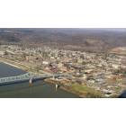
Ironton: Aerial Photo of Downtown Ironton
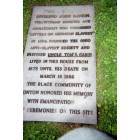
Ironton: Plaque at the Ironton Historical Museum

Ironton: Abandond Section of the Detroit Toledo & Ironton Railroad

Ironton: The Ironton to Russell, KY Bridge

Ironton: Lake Vesuvius Drained to repair the damn

Ironton: Mountains behind our house on N. 4th Street, Ironton, in Winter
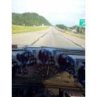
Ironton: Driving Down the Highway in Ironton

Ironton: Old Church in Ironton
- add
your
Submit your own pictures of this city and show them to the world
- OSM Map
- General Map
- Google Map
- MSN Map
Population change since 2000: -8.2%
 |
| Males: 4,744 | |
| Females: 5,546 |
| Median resident age: | 43.2 years |
| Ohio median age: | 39.9 years |
Zip codes: 45638.
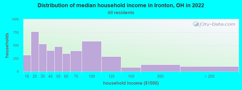
| Ironton: | $42,873 |
| OH: | $65,720 |
Estimated per capita income in 2022: $25,592 (it was $15,391 in 2000)
Ironton city income, earnings, and wages data
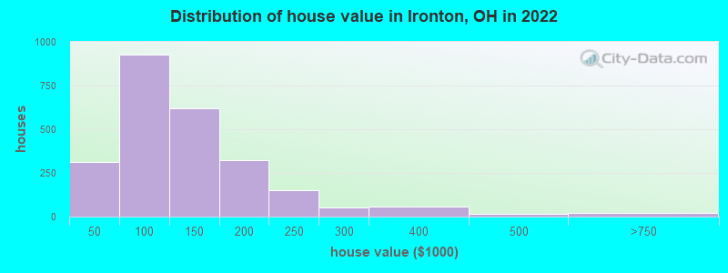
Estimated median house or condo value in 2022: $115,245 (it was $62,900 in 2000)
| Ironton: | $115,245 |
| OH: | $204,100 |
Mean prices in 2022: all housing units: $136,260; detached houses: $136,237; townhouses or other attached units: $175,887; mobile homes: $23,818
Median gross rent in 2022: $732.
(24.4% for White Non-Hispanic residents, 12.4% for Black residents, 16.7% for Hispanic or Latino residents, 52.2% for two or more races residents)
Detailed information about poverty and poor residents in Ironton, OH
Compare current foreclosures near Ironton, OH:
| Photo | Address | Area | Beds / Baths | Price | Details |
|---|---|---|---|---|---|

|
#1
S 5th St
Ironton, OH 45638
|
2,214 sq. feet
|
2 baths 3 beds |
$20,900
|
show details |

|
#2
S 10th St
Ironton, OH 45638
|
1,662 sq. feet
|
2 baths 4 beds |
show details | |

|
#3
Township Road 301a
Ironton, OH 45638
|
1,363 sq. feet
|
1 baths 3 beds |
show details | |

|
#4
S 11th St
Ironton, OH 45638
|
1,206 sq. feet
|
1 baths 3 beds |
show details | |

|
#5
N 5th St
Ironton, OH 45638
|
2,400 sq. feet
|
1 baths 3 beds |
show details | |

|
#6
High St
Ironton, OH 45638
|
1,052 sq. feet
|
1 baths 2 beds |
show details | |

|
#7
N 4th St
Ironton, OH 45638
|
768 sq. feet
|
1 baths 3 beds |
show details | |

|
#8
Oakwood Dr
Ironton, OH 45638
|
1,120 sq. feet
|
2 baths 3 beds |
show details | |

|
#9
N 4th St
Ironton, OH 45638
|
1,096 sq. feet
|
1 baths 3 beds |
show details | |

|
#10
Higgins St
Ironton, OH 45638
|
744 sq. feet
|
1 baths 3 beds |
show details |
| Photo | Address | Area | Beds / Baths | Price | Details |
|---|---|---|---|---|---|

|
#11
S 9th St
Ironton, OH 45638
|
1,450 sq. feet
|
1 baths 2 beds |
show details | |

|
#12
State Route 93
Ironton, OH 45638
|
1,264 sq. feet
|
1 baths 3 beds |
show details | |

|
#13
S 6th St
Ironton, OH 45638
|
1,132 sq. feet
|
1 baths 2 beds |
show details | |

|
#14
S 5th St
Ironton, OH 45638
|
1,534 sq. feet
|
1 baths 4 beds |
show details | |

|
#15
N 3rd St
Ironton, OH 45638
|
960 sq. feet
|
1 baths 2 beds |
show details | |

|
#16
Geswein St
Ironton, OH 45638
|
1,392 sq. feet
|
1 baths 2 beds |
show details | |

|
#17
Washington St
Ironton, OH 45638
|
1,988 sq. feet
|
2 baths 2 beds |
show details | |

|
#18
State Route 93
Ironton, OH 45638
|
- sq. feet
|
- baths - beds |
show details | |

|
#19
County Road 1a
Ironton, OH 45638
|
- sq. feet
|
- baths - beds |
show details | |

|
#20
S 3rd St
Ironton, OH 45638
|
- sq. feet
|
- baths - beds |
show details |
| Photo | Address | Area | Beds / Baths | Price | Details |
|---|---|---|---|---|---|

|
#21
Township Road 385 Rd # 348
Ironton, OH 45638
|
- sq. feet
|
- baths - beds |
show details | |

|
#22
Ora Ritchey Rd
Ironton, OH 45638
|
- sq. feet
|
- baths - beds |
show details | |

|
#23
German Holw
Ironton, OH 45638
|
- sq. feet
|
- baths - beds |
show details | |

|
#24
S 2nd St
Ironton, OH 45638
|
- sq. feet
|
- baths - beds |
show details | |

|
#25
High St
Ironton, OH 45638
|
- sq. feet
|
- baths - beds |
show details | |

|
#26
Township Road 102
Ironton, OH 45638
|
- sq. feet
|
- baths - beds |
show details | |

|
#27
Hecla St
Ironton, OH 45638
|
- sq. feet
|
- baths - beds |
show details | |

|
#28
Route 75
Kenova, WV 25530
|
1,580 sq. feet
|
2 baths 3 beds |
$174,995
|
show details |

|
#29
Walnut St
Kenova, WV 25530
|
2,063 sq. feet
|
2 baths 4 beds |
$225,000
|
show details |

|
#30
Jackson Ave
Huntington, WV 25704
|
1,450 sq. feet
|
2 baths 2 beds |
$145,000
|
show details |
| Photo | Address | Area | Beds / Baths | Price | Details |
|---|---|---|---|---|---|

|
#31
Township Rd 1007
Chesapeake, OH 45619
|
1,560 sq. feet
|
2 baths 3 beds |
$59,300
|
show details |

|
#32
Twp. Rd 1366
South Point, OH 45680
|
1,144 sq. feet
|
1 baths 2 beds |
$124,900
|
show details |

|
#33
Charleston Ave
Huntington, WV 25701
|
1,200 sq. feet
|
2 baths 4 beds |
$27,900
|
show details |

|
#34
Ridge St
Russell, KY 41169
|
- sq. feet
|
1 baths 3 beds |
$44,900
|
show details |

|
#35
Beech St
Huntington, WV 25701
|
1,524 sq. feet
|
1 baths 3 beds |
$9,900
|
show details |

|
#36
Johnson Ave
Ashland, KY 41102
|
1,950 sq. feet
|
2 baths 3 beds |
show details | |

|
#37
Central Ave
Ashland, KY 41101
|
2 sq. feet
|
1 baths 3 beds |
show details | |

|
#38
State Route 775
Scottown, OH 45678
|
1,056 sq. feet
|
2 baths 3 beds |
show details | |

|
#39
High St W
Ashland, KY 41101
|
754 sq. feet
|
1 baths 2 beds |
show details | |

|
#40
10th Ave
Huntington, WV 25701
|
2,128 sq. feet
|
2 baths 3 beds |
show details |
| Photo | Address | Area | Beds / Baths | Price | Details |
|---|---|---|---|---|---|

|
#41
Wildwood Dr
Ashland, KY 41102
|
912 sq. feet
|
2 baths 3 beds |
show details | |

|
#42
Cumberland Ave
Flatwoods, KY 41139
|
1,450 sq. feet
|
1 baths 3 beds |
show details | |

|
#43
W Happy Rdg
Ashland, KY 41102
|
800 sq. feet
|
1 baths 3 beds |
show details | |

|
#44
Terrace Blvd
Ashland, KY 41102
|
960 sq. feet
|
1 baths 2 beds |
show details | |

|
#45
Township Road 1096
Chesapeake, OH 45619
|
1,300 sq. feet
|
2 baths 3 beds |
show details | |

|
#46
County Road 1
South Point, OH 45680
|
1,152 sq. feet
|
1 baths 3 beds |
show details | |

|
#47
Township Road 1080
Waterloo, OH 45688
|
951 sq. feet
|
1 baths 1 beds |
show details | |

|
#48
State Route 141
Kitts Hill, OH 45645
|
1,396 sq. feet
|
1 baths 2 beds |
show details | |

|
#49
Richardson Rd
Ashland, KY 41101
|
2,560 sq. feet
|
2 baths 4 beds |
show details | |

|
Check over 1 million property listings on Foreclosure.com!
|
browse all offers | |||


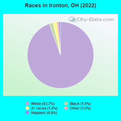
- 9,91493.7%White alone
- 2031.9%Black alone
- 1921.8%Two or more races
- 1101.0%Other race alone
- 830.8%Hispanic
Races in Ironton detailed stats: ancestries, foreign born residents, place of birth
According to our research of Ohio and other state lists, there were 26 registered sex offenders living in Ironton, Ohio as of April 28, 2024.
The ratio of all residents to sex offenders in Ironton is 426 to 1.
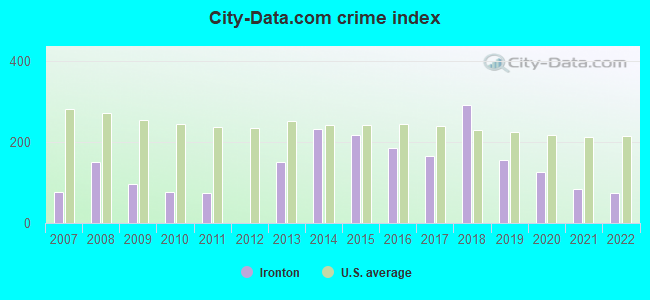
Type |
2009 |
2010 |
2011 |
2012 |
2013 |
2014 |
2015 |
2016 |
2017 |
2018 |
2019 |
2020 |
2021 |
2022 |
|---|---|---|---|---|---|---|---|---|---|---|---|---|---|---|
| Murders (per 100,000) | 0 (0.0) | 0 (0.0) | 1 (9.0) | 0 (0.0) | 0 (0.0) | 1 (9.1) | 0 (0.0) | 0 (0.0) | 0 (0.0) | 0 (0.0) | 1 (9.5) | 0 (0.0) | 0 (0.0) | 0 (0.0) |
| Rapes (per 100,000) | 1 (8.8) | 2 (18.0) | 0 (0.0) | 0 (0.0) | 0 (0.0) | 6 (54.3) | 7 (63.9) | 3 (27.6) | 3 (27.6) | 10 (93.8) | 2 (18.9) | 5 (47.8) | 4 (38.6) | 2 (19.4) |
| Robberies (per 100,000) | 3 (26.5) | 2 (18.0) | 3 (26.9) | 0 (0.0) | 8 (72.4) | 5 (45.3) | 6 (54.7) | 7 (64.5) | 5 (46.1) | 5 (46.9) | 3 (28.4) | 2 (19.1) | 2 (19.3) | 4 (38.8) |
| Assaults (per 100,000) | 1 (8.8) | 3 (27.0) | 2 (18.0) | 0 (0.0) | 10 (90.5) | 7 (63.4) | 16 (145.9) | 11 (101.3) | 8 (73.7) | 10 (93.8) | 13 (122.9) | 15 (143.3) | 6 (57.9) | 9 (87.3) |
| Burglaries (per 100,000) | 60 (530.6) | 38 (341.5) | 31 (278.4) | 0 (0.0) | 67 (606.4) | 91 (823.9) | 68 (620.3) | 70 (644.8) | 66 (608.1) | 51 (478.2) | 50 (472.8) | 28 (267.5) | 24 (231.8) | 16 (155.2) |
| Thefts (per 100,000) | 107 (946.3) | 70 (629.0) | 64 (574.7) | 3 (26.9) | 175 (1,584) | 216 (1,956) | 194 (1,770) | 191 (1,759) | 169 (1,557) | 180 (1,688) | 131 (1,239) | 67 (640.0) | 42 (405.6) | 39 (378.2) |
| Auto thefts (per 100,000) | 8 (70.8) | 2 (18.0) | 4 (35.9) | 0 (0.0) | 7 (63.4) | 13 (117.7) | 9 (82.1) | 10 (92.1) | 15 (138.2) | 111 (1,041) | 10 (94.6) | 10 (95.5) | 5 (48.3) | 6 (58.2) |
| Arson (per 100,000) | 0 (0.0) | 1 (9.0) | 0 (0.0) | 0 (0.0) | 0 (0.0) | 1 (9.1) | 0 (0.0) | 1 (9.2) | 1 (9.2) | 0 (0.0) | 0 (0.0) | 0 (0.0) | 0 (0.0) | 1 (9.7) |
| City-Data.com crime index | 97.5 | 75.7 | 75.0 | 1.1 | 150.7 | 233.1 | 217.5 | 184.6 | 166.6 | 292.0 | 157.3 | 124.6 | 84.6 | 75.3 |
The City-Data.com crime index weighs serious crimes and violent crimes more heavily. Higher means more crime, U.S. average is 246.1. It adjusts for the number of visitors and daily workers commuting into cities.
Crime rate in Ironton detailed stats: murders, rapes, robberies, assaults, burglaries, thefts, arson
Full-time law enforcement employees in 2021, including police officers: 17 (16 officers - 15 male; 1 female).
| Officers per 1,000 residents here: | 1.55 |
| Ohio average: | 2.31 |
 Recent articles from our blog. Our writers, many of them Ph.D. graduates or candidates, create easy-to-read articles on a wide variety of topics.

 | 500,000,000 Huge Win for Middletown/Ohio (37 replies) |
| Moving from Southern California to Ohio (100 replies) |
| Bar/Lounge in Ironton (1 reply) |
| Moving to Portsmouth, Ohio (4 replies) |
| Do you consider Ohio "Midwest" or "Back East?" (360 replies) |
| are the oil and gas industry in the Columbus and Cincinnati areas? (5 replies) |
Latest news from Ironton, OH collected exclusively by city-data.com from local newspapers, TV, and radio stations
Ancestries: American (34.4%), Irish (16.5%), German (12.7%), English (12.0%), Scottish (1.5%), European (1.5%).
Current Local Time: EST time zone
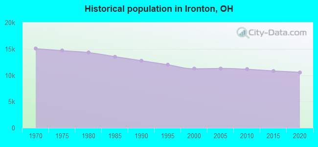
Incorporated in 1980
Elevation: 560 feet
Land area: 4.13 square miles.
Population density: 2,489 people per square mile (low).
7 residents are foreign born
| This city: | 0.1% |
| Ohio: | 4.9% |
Median real estate property taxes paid for housing units with mortgages in 2022: $1,195 (0.9%)
Median real estate property taxes paid for housing units with no mortgage in 2022: $962 (0.9%)
Nearest city with pop. 50,000+: Huntington, WV  (15.6 miles , pop. 51,475).
Nearest city with pop. 200,000+: Columbus, OH (102.3 miles , pop. 711,470).
Nearest city with pop. 1,000,000+: Chicago, IL (349.5 miles , pop. 2,896,016).
Nearest cities:
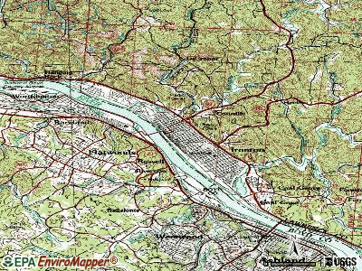
), ), ), ), ), )Latitude: 38.53 N, Longitude: 82.68 W
Daytime population change due to commuting: +465 (+4.4%)
Workers who live and work in this city: 1,449 (37.2%)
Area code: 740

Ironton, Ohio accommodation & food services, waste management - Economy and Business Data
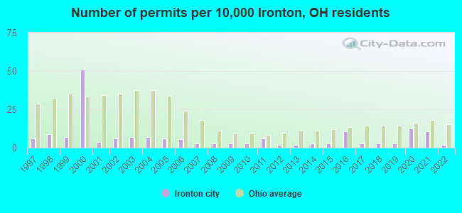
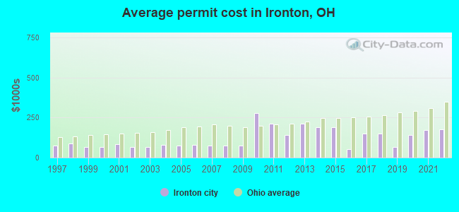
Single-family new house construction building permits:
- 2022: 2 buildings, average cost: $175,000
- 2021: 12 buildings, average cost: $173,300
- 2020: 14 buildings, average cost: $143,000
- 2019: 3 buildings, average cost: $64,000
- 2018: 3 buildings, average cost: $150,300
- 2017: 3 buildings, average cost: $150,300
- 2016: 12 buildings, average cost: $54,600
- 2015: 3 buildings, average cost: $187,900
- 2014: 3 buildings, average cost: $187,900
- 2013: 2 buildings, average cost: $211,900
- 2012: 2 buildings, average cost: $139,900
- 2011: 7 buildings, average cost: $211,900
- 2010: 3 buildings, average cost: $280,300
- 2009: 3 buildings, average cost: $77,200
- 2008: 3 buildings, average cost: $77,200
- 2007: 3 buildings, average cost: $77,100
- 2006: 6 buildings, average cost: $77,500
- 2005: 7 buildings, average cost: $76,400
- 2004: 8 buildings, average cost: $79,600
- 2003: 8 buildings, average cost: $68,400
- 2002: 7 buildings, average cost: $68,400
- 2001: 4 buildings, average cost: $85,400
- 2000: 57 buildings, average cost: $64,500
- 1999: 8 buildings, average cost: $65,800
- 1998: 10 buildings, average cost: $88,300
- 1997: 7 buildings, average cost: $73,000
| Here: | 3.4% |
| Ohio: | 3.1% |
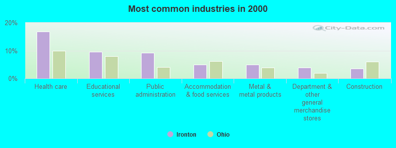
- Health care (16.7%)
- Educational services (9.5%)
- Public administration (9.2%)
- Accommodation & food services (5.0%)
- Metal & metal products (5.0%)
- Department & other general merchandise stores (3.8%)
- Construction (3.5%)
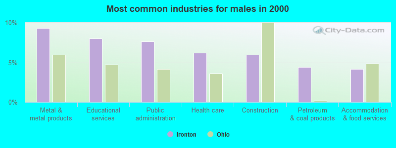
- Metal & metal products (9.3%)
- Educational services (8.0%)
- Public administration (7.6%)
- Health care (6.2%)
- Construction (6.0%)
- Petroleum & coal products (4.4%)
- Accommodation & food services (4.1%)
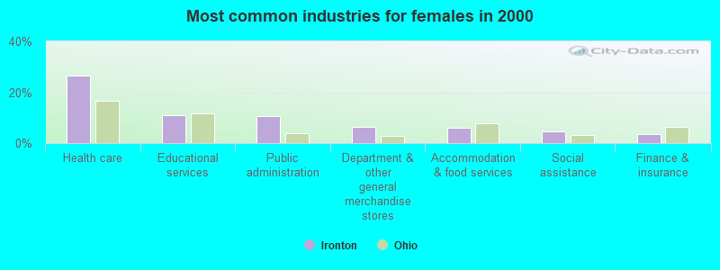
- Health care (26.7%)
- Educational services (10.9%)
- Public administration (10.6%)
- Department & other general merchandise stores (6.3%)
- Accommodation & food services (5.9%)
- Social assistance (4.5%)
- Finance & insurance (3.6%)
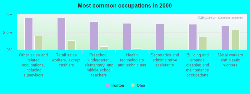
- Other sales and related occupations, including supervisors (4.5%)
- Retail sales workers, except cashiers (4.5%)
- Preschool, kindergarten, elementary, and middle school teachers (4.0%)
- Health technologists and technicians (3.8%)
- Secretaries and administrative assistants (3.7%)
- Building and grounds cleaning and maintenance occupations (3.6%)
- Metal workers and plastic workers (3.4%)
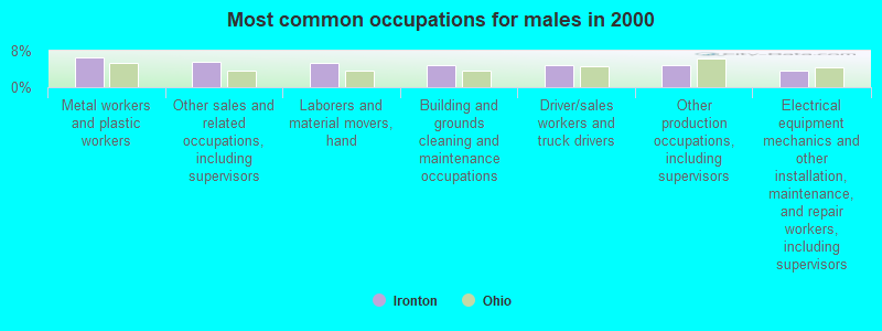
- Metal workers and plastic workers (6.6%)
- Other sales and related occupations, including supervisors (5.6%)
- Laborers and material movers, hand (5.4%)
- Building and grounds cleaning and maintenance occupations (4.8%)
- Driver/sales workers and truck drivers (4.8%)
- Other production occupations, including supervisors (4.8%)
- Electrical equipment mechanics and other installation, maintenance, and repair workers, including supervisors (3.7%)

- Health technologists and technicians (6.7%)
- Secretaries and administrative assistants (6.3%)
- Registered nurses (6.0%)
- Retail sales workers, except cashiers (5.9%)
- Preschool, kindergarten, elementary, and middle school teachers (5.5%)
- Other office and administrative support workers, including supervisors (4.7%)
- Nursing, psychiatric, and home health aides (4.0%)
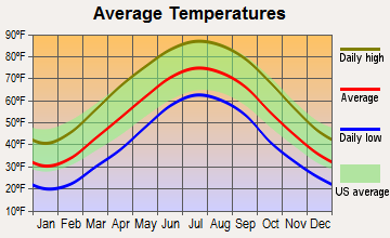
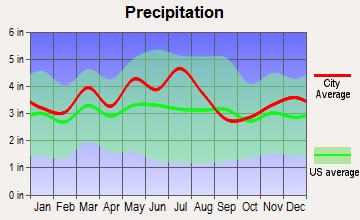
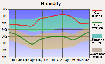
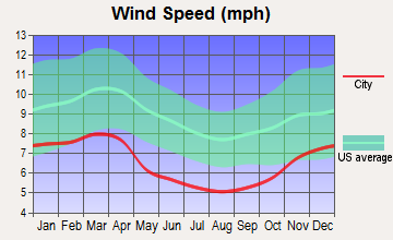
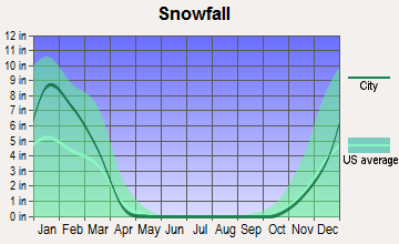
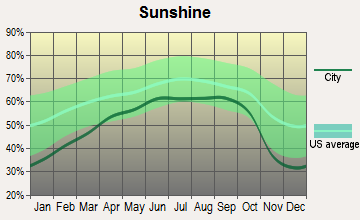
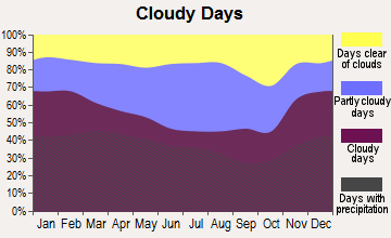
Average climate in Ironton, Ohio
Based on data reported by over 4,000 weather stations
|
|


(lower is better)
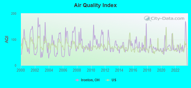
Air Quality Index (AQI) level in 2023 was 90.7. This is worse than average.
| City: | 90.7 |
| U.S.: | 72.6 |
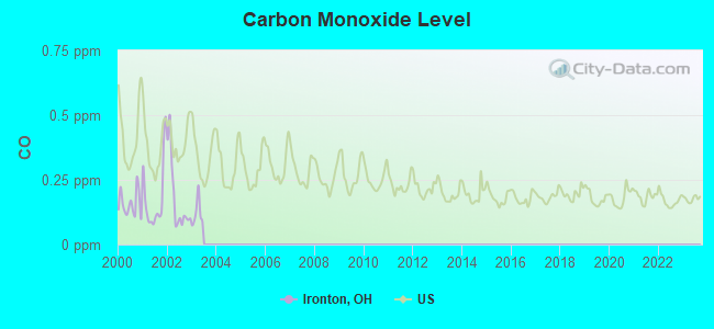
Carbon Monoxide (CO) [ppm] level in 2002 was 0.180. This is better than average. Closest monitor was 4.2 miles away from the city center.
| City: | 0.180 |
| U.S.: | 0.251 |
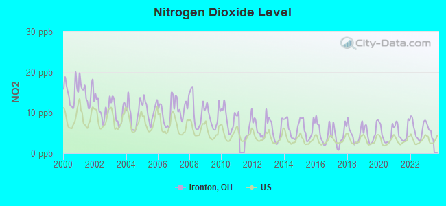
Nitrogen Dioxide (NO2) [ppb] level in 2022 was 5.87. This is about average. Closest monitor was 2.6 miles away from the city center.
| City: | 5.87 |
| U.S.: | 5.11 |
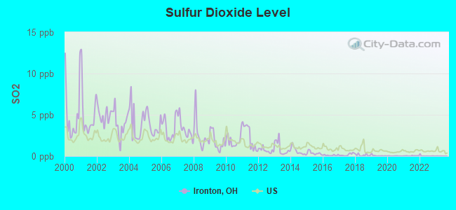
Sulfur Dioxide (SO2) [ppb] level in 2023 was 0.00700. This is significantly better than average. Closest monitor was 0.9 miles away from the city center.
| City: | 0.00700 |
| U.S.: | 1.51465 |

Ozone [ppb] level in 2022 was 25.8. This is better than average. Closest monitor was 0.9 miles away from the city center.
| City: | 25.8 |
| U.S.: | 33.3 |
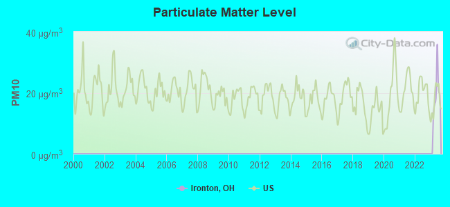
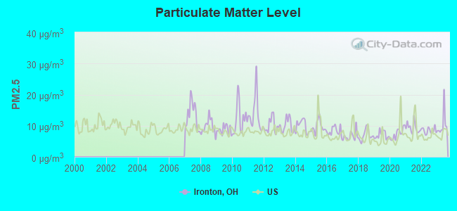
Particulate Matter (PM2.5) [µg/m3] level in 2023 was 10.4. This is worse than average. Closest monitor was 1.0 miles away from the city center.
| City: | 10.4 |
| U.S.: | 8.1 |
Tornado activity:
Ironton-area historical tornado activity is significantly below Ohio state average. It is 48% smaller than the overall U.S. average.
On 4/23/1968, a category F5 (max. wind speeds 261-318 mph) tornado 13.4 miles away from the Ironton city center killed 7 people and injured 93 people and caused between $500,000 and $5,000,000 in damages.
On 4/23/1968, a category F4 (max. wind speeds 207-260 mph) tornado 27.5 miles away from the city center killed 6 people and injured 364 people and caused between $5,000,000 and $50,000,000 in damages.
Earthquake activity:
Ironton-area historical earthquake activity is significantly above Ohio state average. It is 12% greater than the overall U.S. average.On 7/27/1980 at 18:52:21, a magnitude 5.2 (5.1 MB, 4.7 MS, 5.0 UK, 5.2 UK, Class: Moderate, Intensity: VI - VII) earthquake occurred 72.2 miles away from the city center
On 8/23/2011 at 17:51:04, a magnitude 5.8 (5.8 MW, Depth: 3.7 mi) earthquake occurred 261.2 miles away from the city center
On 8/9/2020 at 12:07:37, a magnitude 5.1 (5.1 MW, Depth: 4.7 mi) earthquake occurred 166.6 miles away from the city center
On 9/7/1988 at 02:28:09, a magnitude 4.6 (4.5 MB, 4.6 LG, Class: Light, Intensity: IV - V) earthquake occurred 70.4 miles away from Ironton center
On 9/25/1998 at 19:52:52, a magnitude 5.2 (4.8 MB, 4.3 MS, 5.2 LG, 4.5 MW, Depth: 3.1 mi) earthquake occurred 237.8 miles away from Ironton center
On 4/18/2008 at 09:36:59, a magnitude 5.4 (5.1 MB, 4.8 MS, 5.4 MW, 5.2 MW) earthquake occurred 281.9 miles away from the city center
Magnitude types: regional Lg-wave magnitude (LG), body-wave magnitude (MB), surface-wave magnitude (MS), moment magnitude (MW)
Natural disasters:
The number of natural disasters in Lawrence County (14) is near the US average (15).Major Disasters (Presidential) Declared: 9
Emergencies Declared: 2
Causes of natural disasters: Storms: 9, Floods: 8, Landslides: 2, Blizzard: 1, Hurricane: 1, Mudslide: 1, Snowstorm: 1, Tornado: 1, Wind: 1, Winter Storm: 1, Other: 1 (Note: some incidents may be assigned to more than one category).
Hospitals and medical centers in Ironton:
- RIVER VALLEY HEALTH SYSTEM-IRONTON CPS (2228 S NINTH ST)
- BRYANT HEALTH CARE CENTER INC (5TH AND CLINTON STS)
- JO-LIN HEALTH CENTER INC (1050 CLINTON STREET)
- RIVER VALLEY HEALTH SYSTEM (2228 S NINTH ST)
- SANCTUARY OF THE OHIO VALLEY (2932 SOUTH 5TH STREET)
- FMC - IRONTON (158 N 2ND STREET)
- BELLEFONTE HOME HEALTH CARE AGENCY (207 SOUTH 7TH AVENUE)
- BLESSED AT HOME, LLC (209 NORTH SECOND STREET, SUITE B)
- RIVER VALLEY HOME HEALTH AGENCY (2228 SOUTH 9TH ST, 3RD FLOOR)
Amtrak stations near Ironton:
- 5 miles: ASHLAND (99 15TH ST.) . Services: fully wheelchair accessible, enclosed waiting area, public restrooms, public payphones, vending machines, free short-term parking, free long-term parking, call for taxi service, public transit connection.
- 16 miles: HUNTINGTON (8TH AVE. & 10TH ST.) . Services: ticket office, fully wheelchair accessible, enclosed waiting area, public restrooms, public payphones, free short-term parking, free long-term parking, call for taxi service.
College/University in Ironton:
Colleges/universities with over 2000 students nearest to Ironton:
- Ashland Community and Technical College (about 5 miles; Ashland, KY; Full-time enrollment: 2,482)
- Marshall University (about 16 miles; Huntington, WV; FT enrollment: 11,450)
- Shawnee State University (about 23 miles; Portsmouth, OH; FT enrollment: 4,160)
- Morehead State University (about 48 miles; Morehead, KY; FT enrollment: 7,523)
- West Virginia State University (about 51 miles; Institute, WV; FT enrollment: 2,133)
- Big Sandy Community and Technical College (about 59 miles; Prestonsburg, KY; FT enrollment: 2,660)
- Maysville Community and Technical College (about 62 miles; Maysville, KY; FT enrollment: 2,969)
Public high schools in Ironton:
- ROCK HILL SR HIGH SCHOOL (Students: 484, Location: 2415 COUNTY ROAD 26, Grades: 9-12)
- IRONTON HIGH SCHOOL (Students: 471, Location: 1701 S 7TH ST, Grades: 9-12)
Private high school in Ironton:
Public elementary/middle schools in Ironton:
- ROCK HILL ELEMENTARY SCHOOL (Students: 741, Location: 2676 COUNTY ROAD 26, Grades: PK-5)
- IRONTON ELEMENTARY SCHOOL (Students: 677, Location: 302 DELAWARE ST, Grades: PK-5)
- DAWSON-BRYANT ELEMENTARY SCHOOL (Students: 551, Location: 4503 STATE ROUTE 243, Grades: PK-5)
- ROCK HILL MIDDLE SCHOOL (Students: 394, Location: 2171 COUNTY ROAD 26, Grades: 6-8)
- IRONTON MIDDLE SCHOOL (Students: 316, Location: 302 DELAWARE ST, Grades: 6-8)
Private elementary/middle school in Ironton:
User-submitted facts and corrections:
- River Valley Health System in Ironton is closed. Nearest Hospital is in Bellefonte, KY, or Ashland, KY
- WKEE is now owned by ClearChannel Communications
Points of interest:
Notable locations in Ironton: Ironton Sewage Treatment Plant (A), Oak Ridge (B), Memorial Hall (C), Lawrence County Museum (D), Bide-A-Wee (E), Patriot Emergency Medical Services Ironton Station (F), Southeast Ohio Emergency Medical Services Station 11 Ironton (G), City of Ironton Fire Department (H), Lawrence County Bar and Law Library (I), Briggs-Lawrence County Public Library (J), Ironton City Hall (K), Lawrence County Courthouse (L). Display/hide their locations on the map
Churches in Ironton include: Apostolic Gospel Church (A), Calvary Baptist Church (B), Central Christian Church (C), Christ Episcopal Church (D), Church of Christ (E), Ellison Street Church of the Nazarene (F), Elm Street Church of the Nazarene (G), First Baptist Church of Ironton (H), First Presbyterian Church (I). Display/hide their locations on the map
Cemetery: Kelly Cemetery (1). Display/hide its location on the map
Streams, rivers, and creeks: Storms Creek (A), Yellow Branch (B). Display/hide their locations on the map
Parks in Ironton include: Rankin Historic District (1), Fifth and Lawrence Streets Residential Historic District (2), Beechwood Park (3). Display/hide their locations on the map
Tourist attractions: Ohio University Nature Center (Nature Centers; 1008 Co Road 29), City Amusement Enterprise (Amusement & Theme Parks; 1606 South 2nd Street).
Hotel: Grandview Inn (154 Co Road 450).
Court: Lawrence County Courthouse Ironton (111 South 4th Street).
Birthplace of: John K. Richards - Federal judge, Terry Waldo - Musician, William S. Livingston - Recipient of the Purple Heart medal, George Richards (Marine Corps) - Marine Corps Brevet Medal recipient, William C. Lambert - World War I flying ace, Charlie Hastings - Baseball player, Elza Jeffords - Representative, Harlan Hatcher - Anti-communist, Kelli Sobonya - Politician, Terry Enyart - Baseball player.
Drinking water stations with addresses in Ironton and their reported violations in the past:
HECLA WATER ASSOCIATION-PLANT PWS (Population served: 30,399, Purch surface water):Past monitoring violations:
- Monitoring and Reporting (DBP) - Between JUL-2013 and SEP-2013, Contaminant: Total Haloacetic Acids (HAA5). Follow-up actions: St Compliance achieved (NOV-14-2013), St Public Notif requested (NOV-25-2013), St Violation/Reminder Notice (NOV-25-2013), St Public Notif received (JUN-26-2014)
- Monitoring and Reporting (DBP) - Between JUL-2013 and SEP-2013, Contaminant: TTHM. Follow-up actions: St Compliance achieved (NOV-14-2013), St Public Notif requested (NOV-25-2013), St Violation/Reminder Notice (NOV-25-2013), St Public Notif received (JUN-26-2014)
| This city: | 2.2 people |
| Ohio: | 2.4 people |
| This city: | 59.8% |
| Whole state: | 65.0% |
| This city: | 6.0% |
| Whole state: | 6.8% |
Likely homosexual households (counted as self-reported same-sex unmarried-partner households)
- Lesbian couples: 0.3% of all households
- Gay men: 0.2% of all households
People in group quarters in Ironton in 2010:
- 220 people in nursing facilities/skilled-nursing facilities
- 90 people in local jails and other municipal confinement facilities
- 35 people in workers' group living quarters and job corps centers
- 10 people in residential treatment centers for juveniles (non-correctional)
- 10 people in other noninstitutional facilities
- 6 people in group homes intended for adults
People in group quarters in Ironton in 2000:
- 247 people in nursing homes
- 25 people in other noninstitutional group quarters
- 22 people in training schools for juvenile delinquents
- 22 people in other group homes
- 9 people in homes for the mentally ill
Banks with branches in Ironton (2011 data):
- U.S. Bank National Association: Ironton Branch at 120 South Third Street, branch established on 1976/09/30; Jones Street Branch at 2301 South Third Street, branch established on 1957/10/14. Info updated 2012/01/30: Bank assets: $330,470.8 mil, Deposits: $236,091.5 mil, headquarters in Cincinnati, OH, positive income, 3121 total offices, Holding Company: U.S. Bancorp
- City National Bank of West Virginia: Ironton Branch at 506 Park Avenue, branch established on 1935/06/01. Info updated 2008/01/10: Bank assets: $2,753.2 mil, Deposits: $2,223.1 mil, headquarters in Charleston, WV, positive income, Commercial Lending Specialization, 68 total offices, Holding Company: City Holding Company
- Liberty Federal Savings Bank: at 314 Park Avenue, branch established on 1896/01/01. Info updated 2011/07/21: Bank assets: $53.5 mil, Deposits: $46.5 mil, local headquarters, positive income, Mortgage Lending Specialization, 2 total offices
- Ohio River Bank: at 221 Railroad Street, branch established on 1995/05/22. Info updated 2012/01/04: Bank assets: $94.6 mil, Deposits: $78.1 mil, local headquarters, positive income, Commercial Lending Specialization, 3 total offices, Holding Company: Premier Financial Bancorp, Inc.
- PNC Bank, National Association: Ironton-Main Branch at 110 South Fourth Street, branch established on 1962/11/19. Info updated 2012/03/20: Bank assets: $263,309.6 mil, Deposits: $197,343.0 mil, headquarters in Wilmington, DE, positive income, Commercial Lending Specialization, 3085 total offices, Holding Company: Pnc Financial Services Group, Inc., The
- Wesbanco Bank, Inc.: Ironton Branch at 311 South Fifth Street, branch established on 1864/02/27. Info updated 2009/04/02: Bank assets: $5,520.2 mil, Deposits: $4,394.5 mil, headquarters in Wheeling, WV, positive income, Commercial Lending Specialization, 115 total offices, Holding Company: Wesbanco, Inc.
For population 15 years and over in Ironton:
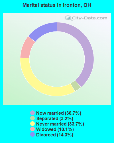
- Never married: 33.7%
- Now married: 38.7%
- Separated: 3.2%
- Widowed: 10.1%
- Divorced: 14.3%
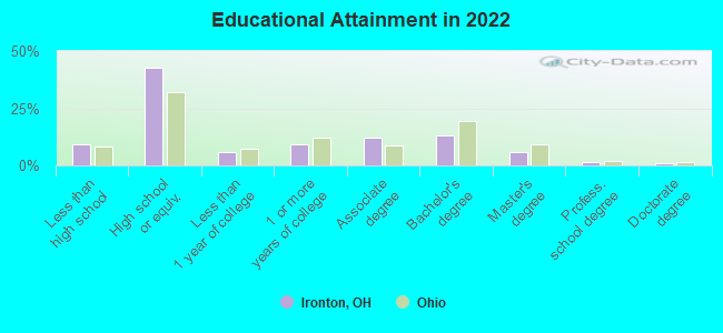
For population 25 years and over in Ironton:
- High school or higher: 90.4%
- Bachelor's degree or higher: 20.0%
- Graduate or professional degree: 7.6%
- Unemployed: 10.7%
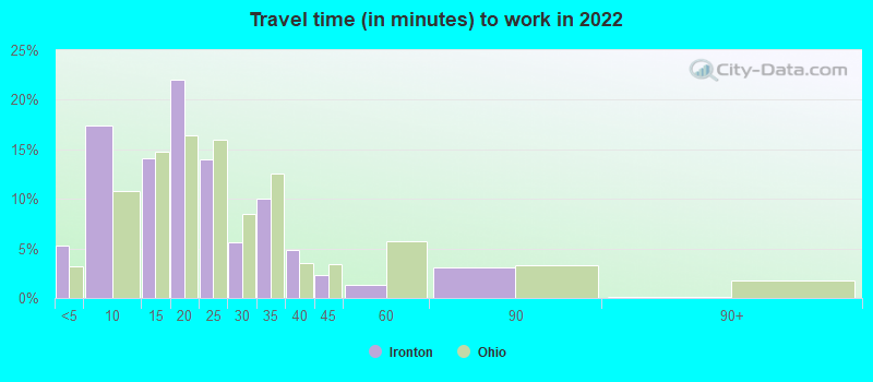
- Mean travel time to work (commute): 20.2 minutes
| Here: | 10.1 |
| Ohio average: | 11.0 |
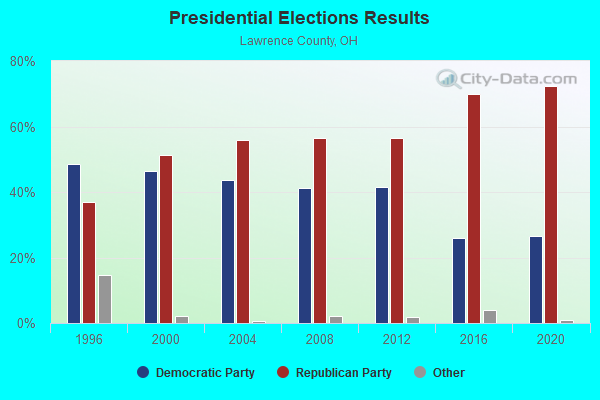
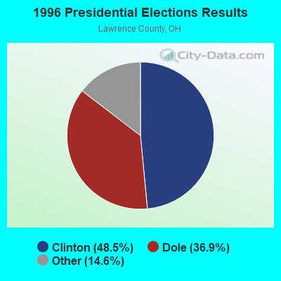
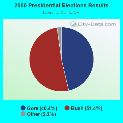
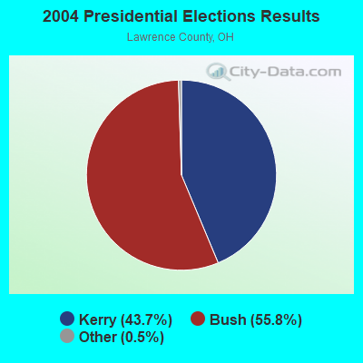
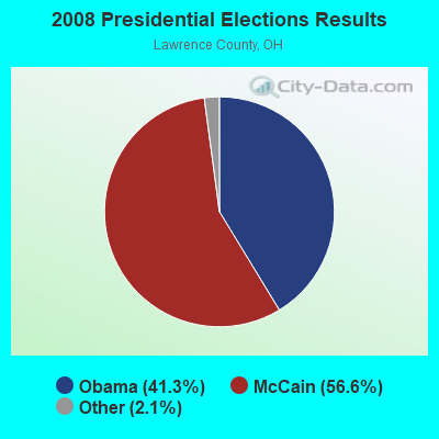
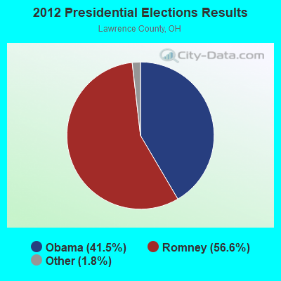
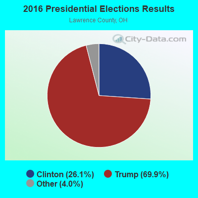
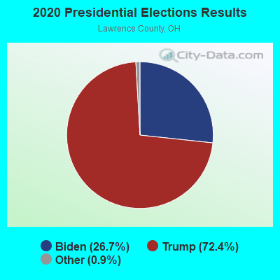
Graphs represent county-level data. Detailed 2008 Election Results
Religion statistics for Ironton, OH (based on Lawrence County data)

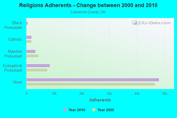
| Religion | Adherents | Congregations |
|---|---|---|
| Evangelical Protestant | 8,556 | 58 |
| Mainline Protestant | 3,259 | 23 |
| Catholic | 1,928 | 4 |
| Black Protestant | 536 | 4 |
| Other | 125 | 3 |
| None | 48,046 | - |
Food Environment Statistics:
| Here: | 1.60 / 10,000 pop. |
| Ohio: | 1.89 / 10,000 pop. |
| Here: | 0.16 / 10,000 pop. |
| Ohio: | 0.13 / 10,000 pop. |
| Lawrence County: | 0.64 / 10,000 pop. |
| State: | 1.25 / 10,000 pop. |
| Lawrence County: | 4.63 / 10,000 pop. |
| Ohio: | 2.93 / 10,000 pop. |
| Lawrence County: | 3.04 / 10,000 pop. |
| Ohio: | 6.25 / 10,000 pop. |
| Here: | 11.4% |
| Ohio: | 10.3% |
| Lawrence County: | 32.5% |
| State: | 29.1% |
| Lawrence County: | 14.1% |
| Ohio: | 11.9% |
Health and Nutrition:
| This city: | 54.0% |
| State: | 50.4% |
| Ironton: | 52.4% |
| Ohio: | 47.8% |
| Ironton: | 28.3 |
| State: | 28.7 |
| Ironton: | 18.0% |
| Ohio: | 20.6% |
| Ironton: | 9.0% |
| Ohio: | 10.4% |
| Here: | 6.9 |
| State: | 6.8 |
| Ironton: | 34.9% |
| Ohio: | 34.3% |
| Ironton: | 59.9% |
| Ohio: | 57.0% |
| This city: | 78.6% |
| Ohio: | 79.1% |
More about Health and Nutrition of Ironton, OH Residents
| Local government employment and payroll (March 2022) | |||||
| Function | Full-time employees | Monthly full-time payroll | Average yearly full-time wage | Part-time employees | Monthly part-time payroll |
|---|---|---|---|---|---|
| Water Supply | 17 | $62,341 | $44,005 | 0 | $0 |
| Police Protection - Officers | 15 | $63,105 | $50,484 | 0 | $0 |
| Firefighters | 15 | $68,204 | $54,563 | 0 | $0 |
| Judicial and Legal | 14 | $45,537 | $39,032 | 5 | $11,269 |
| Sewerage | 9 | $36,292 | $48,389 | 0 | $0 |
| Solid Waste Management | 6 | $15,524 | $31,048 | 0 | $0 |
| Financial Administration | 6 | $22,632 | $45,264 | 0 | $0 |
| Streets and Highways | 5 | $17,967 | $43,121 | 0 | $0 |
| Police - Other | 2 | $16,758 | $100,548 | 0 | $0 |
| Other and Unallocable | 2 | $12,892 | $77,352 | 0 | $0 |
| Natural Resources | 2 | $9,362 | $56,172 | 0 | $0 |
| Electric Power | 1 | $7,356 | $88,272 | 0 | $0 |
| Fire - Other | 1 | $5,385 | $64,620 | 0 | $0 |
| Parks and Recreation | 1 | $498 | $5,976 | 0 | $0 |
| Airports | 1 | $1,723 | $20,676 | 0 | $0 |
| Housing and Community Development (Local) | 1 | $7,783 | $93,396 | 0 | $0 |
| Other Government Administration | 0 | $0 | 2 | $1,620 | |
| Totals for Government | 98 | $393,359 | $48,166 | 7 | $12,889 |
Ironton government finances - Expenditure in 2018 (per resident):
- Construction - General - Other: $1,133,000 ($110.11)
- Current Operations - Sewerage: $2,921,000 ($283.87)
Police Protection: $2,137,000 ($207.68)
Local Fire Protection: $1,425,000 ($138.48)
Water Utilities: $1,349,000 ($131.10)
Financial Administration: $1,184,000 ($115.06)
Central Staff Services: $1,184,000 ($115.06)
Solid Waste Management: $868,000 ($84.35)
Sea and Inland Port Facilities: $713,000 ($69.29)
Regular Highways: $630,000 ($61.22)
General - Other: $588,000 ($57.14)
Parks and Recreation: $118,000 ($11.47)
Health - Other: $5,000 ($0.49)
- General - Interest on Debt: $491,000 ($47.72)
- Intergovernmental to State - Sewerage: $316,000 ($30.71)
General - Other: $19,000 ($1.85)
- Other Capital Outlay - General - Other: $162,000 ($15.74)
- Total Salaries and Wages: $1,819,000 ($176.77)
- Water Utilities - Interest on Debt: $130,000 ($12.63)
Ironton government finances - Revenue in 2018 (per resident):
- Charges - Sewerage: $1,714,000 ($166.57)
Other: $1,441,000 ($140.04)
Solid Waste Management: $712,000 ($69.19)
Sea and Inland Port Facilities: $152,000 ($14.77)
- Miscellaneous - Fines and Forfeits: $908,000 ($88.24)
General Revenue - Other: $478,000 ($46.45)
Interest Earnings: $392,000 ($38.10)
Special Assessments: $3,000 ($0.29)
Sale of Property: $1,000 ($0.10)
- Revenue - Water Utilities: $2,019,000 ($196.21)
- State Intergovernmental - Other: $2,049,000 ($199.13)
General Local Government Support: $638,000 ($62.00)
- Tax - Property: $3,210,000 ($311.95)
Individual Income: $206,000 ($20.02)
Other License: $35,000 ($3.40)
Ironton government finances - Debt in 2018 (per resident):
- Long Term Debt - Beginning Outstanding - Unspecified Public Purpose: $6,389,000 ($620.89)
Outstanding Unspecified Public Purpose: $3,685,000 ($358.11)
Retired Unspecified Public Purpose: $2,704,000 ($262.78)
Ironton government finances - Cash and Securities in 2018 (per resident):
- Bond Funds - Cash and Securities: $16,000 ($1.55)
- Other Funds - Cash and Securities: $6,583,000 ($639.75)
- Sinking Funds - Cash and Securities: $35,000 ($3.40)
| Businesses in Ironton, OH | ||||
| Name | Count | Name | Count | |
|---|---|---|---|---|
| AT&T | 1 | New Balance | 1 | |
| Advance Auto Parts | 1 | Nike | 1 | |
| AutoZone | 1 | Papa John's Pizza | 1 | |
| Buffalo Wild Wings | 1 | Pizza Hut | 1 | |
| CVS | 2 | Rite Aid | 1 | |
| Chevrolet | 1 | Subway | 1 | |
| FedEx | 2 | Taco Bell | 1 | |
| H&R Block | 1 | True Value | 1 | |
| KFC | 1 | U-Haul | 1 | |
| Little Caesars Pizza | 1 | UPS | 3 | |
| Long John Silver's | 1 | Wendy's | 1 | |
| McDonald's | 1 | |||
Strongest AM radio stations in Ironton:
- WIRO (1230 AM; 1 kW; IRONTON, OH; Owner: CAPSTAR TX LIMITED PARTNERSHIP)
- WTCR (1420 AM; 5 kW; KENOVA, WV; Owner: CAPSTAR TX LIMITED PARTNERSHIP)
- WLGC (1520 AM; daytime; 5 kW; GREENUP, KY; Owner: GREENUP COUNTY BROADCASTING, INC.)
- WRVC (930 AM; 5 kW; HUNTINGTON, WV; Owner: FIFTH AVENUE BROADCASTING COMPANY, INC.)
- WVHU (800 AM; 5 kW; HUNTINGTON, WV; Owner: CAPSTAR TX LIMITED PARTNERSHIP)
- WOKT (1040 AM; daytime; 2 kW; CANNONSBURG, KY; Owner: BIG RIVER RADIO, INC.-KY)
- WHRD (1470 AM; 5 kW; HUNTINGTON, WV; Owner: CONCORD MEDIA GROUP, INC.)
- WCMI (1340 AM; 1 kW; ASHLAND, KY; Owner: FIFTH AVENUE BROADCASTING CO., INC)
- WTVN (610 AM; 50 kW; COLUMBUS, OH; Owner: CITICASTERS LICENSES, L.P.)
- WGOH (1370 AM; 5 kW; GRAYSON, KY; Owner: CARTER COUNTY BROADCASTING CO., INC.)
- WBGS (1030 AM; daytime; 10 kW; POINT PLEASANT, WV; Owner: BIG RIVER RADIO, INC.)
- WLW (700 AM; 50 kW; CINCINNATI, OH; Owner: JACOR BROADCASTING CORPORATION)
- WNXT (1260 AM; 5 kW; PORTSMOUTH, OH; Owner: HOMETOWN B/C OF PORTSMOUTH, INC.)
Strongest FM radio stations in Ironton:
- WBKS (107.1 FM; IRONTON, OH; Owner: CAPSTAR TX LIMITED PARTNERSHIP)
- WOUL-FM (89.1 FM; IRONTON, OH; Owner: OHIO UNIVERSITY)
- WBVB (97.1 FM; COAL GROVE, OH; Owner: CAPSTAR TX LIMITED PARTNERSHIP)
- WRVC-FM (92.7 FM; CATLETTSBURG, KY; Owner: FIFTH AVENUE BROADCASTING CO., INC)
- WDGG (93.7 FM; ASHLAND, KY; Owner: FIFTH AVENUE B/CASTING COMPANY, INC.)
- WPAY-FM (104.1 FM; PORTSMOUTH, OH; Owner: RADIO STATIONS WPAY/WPFB, INC.)
- WLGC-FM (105.7 FM; GREENUP, KY; Owner: GREENUP COUNTY BROADCASTING, INC.)
- WKEE-FM (100.5 FM; HUNTINGTON, WV; Owner: CAPSTAR TX LIMITED PARTNERSHIP)
- WOSP (91.5 FM; PORTSMOUTH, OH; Owner: THE OHIO STATE UNIVERSITY)
- WVWV (89.9 FM; HUNTINGTON, WV; Owner: WEST VIRGINIA EDUCATIONAL BROADCASTING AUTHORITY)
- WAMX (106.3 FM; MILTON, WV; Owner: CAPSTAR TX LIMITED PARTNERSHIP)
- WKLC-FM (105.1 FM; ST. ALBANS, WV; Owner: WKLC, INC.)
- WTCR-FM (103.3 FM; HUNTINGTON, WV; Owner: CAPSTAR TX LIMITED PARTNERSHIP)
- W216AT (91.1 FM; ASHLAND, KY; Owner: AMERICAN FAMILY ASSOCIATION)
- WOHP (88.3 FM; PORTSMOUTH, OH; Owner: THE CEDARVILLE UNIVERSITY)
- WNXT-FM (99.3 FM; PORTSMOUTH, OH; Owner: HOMETOWN B/C OF PORTSMOUTH, INC.)
- WRYV-FM1 (101.5 FM; HUNTINGTON, WV; Owner: LEGEND COMMUNICATIONS OF OHIO, LLC)
- W215AV (90.9 FM; SOUTH PORTSMOUTH, KY; Owner: CALVARY CHAPEL OF TWIN FALLS, INC.)
- WOKE (98.3 FM; GARRISON, KY; Owner: BIG RIVER RADIO, INC.)
- WZZZ (107.5 FM; PORTSMOUTH, OH; Owner: HOMETOWN BROADCASTING OF PORTSMOUTH 2, INC.)
TV broadcast stations around Ironton:
- WKAS (Channel 25; ASHLAND, KY; Owner: KENTUCKY AUTHORITY FOR EDUCATIONAL TV)
- WPBY-TV (Channel 33; HUNTINGTON, WV; Owner: WEST VIRGINIA EDUCATIONAL BROADCASTING AUTHORITY)
- WSAZ-TV (Channel 3; HUNTINGTON, WV; Owner: EMMIS TELEVISION LICENSE CORPORATION)
- WOWK-TV (Channel 13; HUNTINGTON, WV; Owner: WEST VIRGINIA MEDIA HOLDINGS, LLC)
- WVAH-TV (Channel 11; CHARLESTON, WV; Owner: WVAH LICENSEE, LLC)
- WPBO (Channel 42; PORTSMOUTH, OH; Owner: THE OHIO STATE UNIVERSITY)
- W14CU (Channel 14; HUNTINGTON, WV; Owner: VENTANA TELEVISION, INC.)
- W49BN (Channel 49; HUNTINGTON, WV; Owner: PAXSON COMMUNCATIONS LPTV, INC.)
- WHCP (Channel 30; PORTSMOUTH, OH; Owner: TELEVISION PROPERTIES, INC.)
- WCHS-TV (Channel 8; CHARLESTON, WV; Owner: WCHS LICENSEE, LLC)
- WTSF (Channel 61; ASHLAND, KY; Owner: TRI STATE FAMILY BROADCASTING, INC.)
- W05CB (Channel 5; BURLINGTON, OH; Owner: VEARL R. PENNINGTON)
- W36CR (Channel 36; HUNTINGTON, WV; Owner: NATIONAL MINORITY T.V., INC.)
- W66CZ (Channel 66; PORTSMOUTH, OH; Owner: TRINITY BROADCASTING NETWORK)
- W55AT (Channel 55; HUNTINGTON, WV; Owner: CHANNEL AMERICA LPTV LIC. SUBSIDIARY)
- National Bridge Inventory (NBI) Statistics
- 39Number of bridges
- 741ft / 226mTotal length
- $177,000Total costs
- 172,661Total average daily traffic
- 14,013Total average daily truck traffic
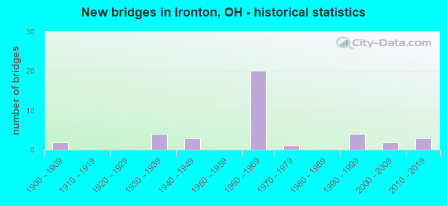
- New bridges - historical statistics
- 21900-1909
- 41930-1939
- 31940-1949
- 201960-1969
- 11970-1979
- 41990-1999
- 22000-2009
- 32010-2019
FCC Registered Antenna Towers:
66 (See the full list of FCC Registered Antenna Towers in Ironton)FCC Registered Commercial Land Mobile Towers:
2 (See the full list of FCC Registered Commercial Land Mobile Towers in Ironton, OH)FCC Registered Private Land Mobile Towers:
4 (See the full list of FCC Registered Private Land Mobile Towers)FCC Registered Broadcast Land Mobile Towers:
15 (See the full list of FCC Registered Broadcast Land Mobile Towers)FCC Registered Microwave Towers:
21 (See the full list of FCC Registered Microwave Towers in this town)FCC Registered Amateur Radio Licenses:
87 (See the full list of FCC Registered Amateur Radio Licenses in Ironton)FAA Registered Aircraft:
5- Aircraft: BALLOON WORKS FIREFLY 7-15 (Category: Land, Weight: Up to 12,499 Pounds), Engine: None
N-Number: 25272, N25272, N-25272, Serial Number: F7-768, Airworthiness Date: 02/20/1992
Registrant (Individual): Reported Sale, 619 S 4th St, Ironton, OH 45638 - Aircraft: CESSNA 177 (Category: Land, Seats: 4, Weight: Up to 12,499 Pounds, Speed: 108 mph), Engine: LYCOMING 0-320 SERIES (180 HP) (Reciprocating)
N-Number: 29448, N29448, N-29448, Serial Number: 17700894, Year manufactured: 1968, Airworthiness Date: 02/08/1968, Certificate Issue Date: 05/08/2009
Registrant (Individual): Thomas L Riley, 2631 S 13th St, Ironton, OH 45638 - Aircraft: PIPER J3C-65 (Category: Land, Seats: 2, Weight: Up to 12,499 Pounds, Speed: 67 mph), Engine: CONT MOTOR A&C75 SERIES (75 HP) (Reciprocating)
N-Number: 3272N, N3272N, N-3272N, Serial Number: 22463, Year manufactured: 1946, Airworthiness Date: 08/21/1955, Certificate Issue Date: 10/26/2020
Registrant (Co-Owned): William L Nenni, 1643 Bessemer St, Ironton, OH 45638, Other Owners: Kathy A Nenni - Aircraft: BUCKEYE AVIATION INC DREAM MACHINE (Category: Land, Seats: 2, Weight: Up to 12,499 Pounds), Engine: ROTAX 582SER (65 HP) (2 Cycle)
N-Number: 4067M, N4067M, N-4067M, Serial Number: 16356, Year manufactured: 2003, Airworthiness Date: 04/22/2007, Certificate Issue Date: 08/12/2020
Registrant (Individual): Ronald D Dickess, 1435 Shawnee Trl, Ironton, OH 45638 - Aircraft: GALAXY BALLOONS INC GALAXY 7 (Category: Land, Seats: 3, Weight: Up to 12,499 Pounds), Engine: None
N-Number: 5222N, N5222N, N-5222N, Serial Number: GLX-1727, Year manufactured: 1995, Airworthiness Date: 05/10/1995, Certificate Issue Date: 10/30/2014
Registrant (Individual): Robert A Cleary, 619 S 4th St, Ironton, OH 45638
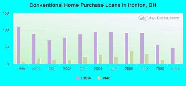
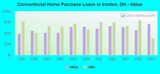
| Home Mortgage Disclosure Act Aggregated Statistics For Year 2009 (Based on 3 full and 1 partial tracts) | ||||||||||||||
| A) FHA, FSA/RHS & VA Home Purchase Loans | B) Conventional Home Purchase Loans | C) Refinancings | D) Home Improvement Loans | E) Loans on Dwellings For 5+ Families | F) Non-occupant Loans on < 5 Family Dwellings (A B C & D) | G) Loans On Manufactured Home Dwelling (A B C & D) | ||||||||
|---|---|---|---|---|---|---|---|---|---|---|---|---|---|---|
| Number | Average Value | Number | Average Value | Number | Average Value | Number | Average Value | Number | Average Value | Number | Average Value | Number | Average Value | |
| LOANS ORIGINATED | 25 | $89,563 | 48 | $71,055 | 125 | $81,962 | 17 | $25,958 | 1 | $192,630 | 35 | $56,620 | 1 | $19,600 |
| APPLICATIONS APPROVED, NOT ACCEPTED | 1 | $42,900 | 4 | $66,910 | 13 | $110,163 | 1 | $7,000 | 0 | $0 | 2 | $99,750 | 0 | $0 |
| APPLICATIONS DENIED | 8 | $84,905 | 6 | $51,673 | 61 | $84,116 | 39 | $33,458 | 0 | $0 | 8 | $47,680 | 2 | $41,370 |
| APPLICATIONS WITHDRAWN | 3 | $109,350 | 5 | $87,188 | 27 | $91,904 | 0 | $0 | 0 | $0 | 3 | $80,737 | 0 | $0 |
| FILES CLOSED FOR INCOMPLETENESS | 1 | $50,780 | 1 | $52,600 | 8 | $91,932 | 2 | $39,220 | 0 | $0 | 1 | $45,310 | 0 | $0 |
Detailed HMDA statistics for the following Tracts: 0501.00 , 0502.00, 0503.00, 0504.00
| Private Mortgage Insurance Companies Aggregated Statistics For Year 2009 (Based on 2 full and 1 partial tracts) | ||||
| A) Conventional Home Purchase Loans | B) Refinancings | |||
|---|---|---|---|---|
| Number | Average Value | Number | Average Value | |
| LOANS ORIGINATED | 2 | $39,150 | 5 | $97,060 |
| APPLICATIONS APPROVED, NOT ACCEPTED | 0 | $0 | 1 | $140,130 |
| APPLICATIONS DENIED | 0 | $0 | 1 | $106,820 |
| APPLICATIONS WITHDRAWN | 0 | $0 | 0 | $0 |
| FILES CLOSED FOR INCOMPLETENESS | 0 | $0 | 0 | $0 |
Detailed PMIC statistics for the following Tracts: 0501.00 , 0502.00, 0503.00, 0504.00
2002 - 2018 National Fire Incident Reporting System (NFIRS) incidents
- Fire incident types reported to NFIRS in Ironton, OH
- 1,00643.0%Structure Fires
- 94240.2%Outside Fires
- 38616.5%Mobile Property/Vehicle Fires
- 70.3%Other
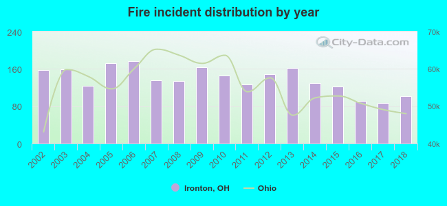 Based on the data from the years 2002 - 2018 the average number of fire incidents per year is 138. The highest number of fires - 177 took place in 2006, and the least - 87 in 2017. The data has a dropping trend.
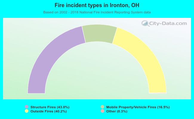 When looking into fire subcategories, the most incidents belonged to: Structure Fires (43.0%), and Outside Fires (40.2%).
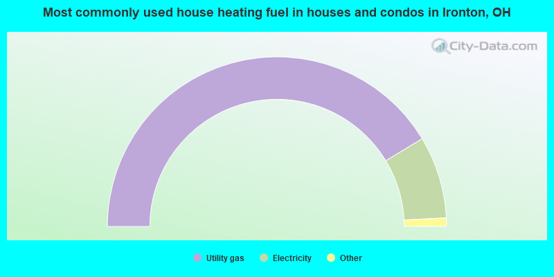
- 82.7%Utility gas
- 15.7%Electricity
- 1.4%Bottled, tank, or LP gas
- 0.2%Other fuel
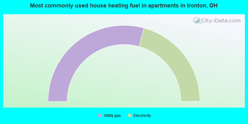
- 58.5%Utility gas
- 41.5%Electricity
Ironton compared to Ohio state average:
- Median household income below state average.
- Median house value below state average.
- Black race population percentage significantly below state average.
- Hispanic race population percentage significantly below state average.
- Foreign-born population percentage significantly below state average.
- Length of stay since moving in significantly above state average.
- House age above state average.
- Number of college students below state average.
Ironton on our top lists:
- #58 on the list of "Top 101 cities with largest percentage of males in industries: health care and social assistance (population 5,000+)"
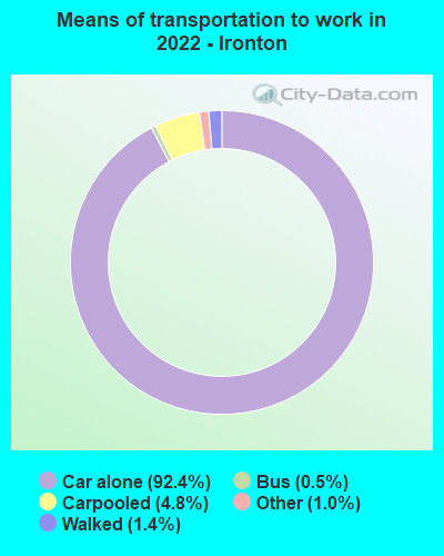
- #81 on the list of "Top 101 cities with the most people driving a car to work alone (population 5,000+)"
- #85 on the list of "Top 100 high-educated but low-earning cities (pop. 5,000+)"
- #20 on the list of "Top 101 counties with the smallest number of children under 18 without health insurance coverage in 2000 (pop. 50,000+)"
- #26 on the list of "Top 101 counties with the smallest number of people without health insurance coverage in 2000 (pop. 50,000+)"
- #80 on the list of "Top 101 counties with the lowest percentage of residents relocating to other counties in 2011 (pop. 50,000+)"
- #82 on the list of "Top 101 counties with the highest Particulate Matter (PM2.5) Annual air pollution readings in 2012 (µg/m3)"
- #91 on the list of "Top 101 counties with the highest number of deaths per 1000 residents 2007-2013 (pop. 50,000+)"

|
|
Total of 19 patent applications in 2008-2024.