Bridge Statistics for Irvine, California (CA)
Condition, Traffic, Stress, Structural Evaluation, Project Costs
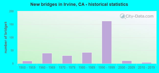
- New bridges - historical statistics
- 11920-1929
- 11930-1939
- 101950-1959
- 401960-1969
- 311970-1979
- 431980-1989
- 1631990-1999
- 112000-2009
- 52010-2019
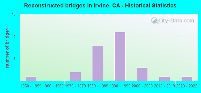
- Reconstructed bridges - Historical Statistics
- 11950-1959
- 01960-1969
- 21970-1979
- 81980-1989
- 111990-1999
- 32000-2009
- 12010-2019
- 12020-2022
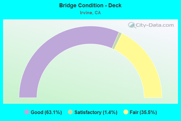
- Bridge Condition - Deck
- 63.1%Good
- 1.4%Satisfactory
- 35.5%Fair
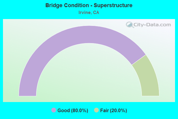
- Bridge Condition - Superstructure
- 80.0%Good
- 20.0%Fair
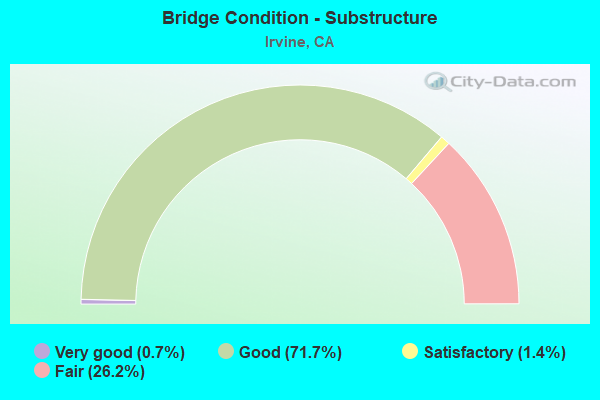
- Bridge Condition - Substructure
- 0.7%Very good
- 71.7%Good
- 1.4%Satisfactory
- 26.2%Fair
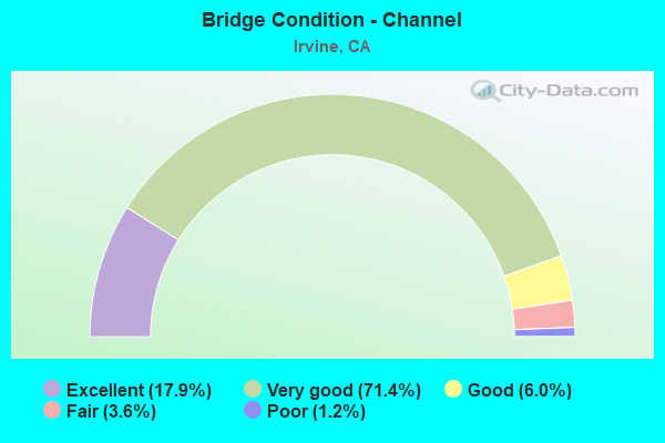
- Bridge Condition - Channel
- 17.9%Excellent
- 71.4%Very good
- 6.0%Good
- 3.6%Fair
- 1.2%Poor
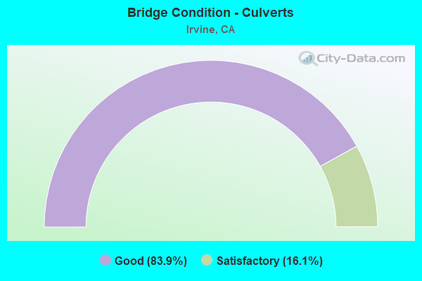
- Bridge Condition - Culverts
- 83.9%Good
- 16.1%Satisfactory
Find on map >> Show street view
Structure Number: 55 0665, Location: 12-ORA-005-22.80-IRVN (Lat: 33.660272, Lng: -117.748114), Route carried "on" structure: City street M029, Year Built: 1990, Status: Open, Structure Length: 10.06m (33.01ft), Average Daily Traffic: 19,000 (year 2017), Truck Traffic: 3%, Average Future Daily Traffic: 20,000 (year 2038), Design Load: HS 20+Mod, Features Intersected: INTERSTATE 5, Facility Carried by Structure: BARRANCA PARKWAY
Minimum Vertical Clearance: 30+ m (98+ ft), Kilometerpoint: 0.000, Lanes on structure: 5, Lanes under structure: 12, Owner: State Highway Agency, Approaching Roadway Width: 27.4m (89.9ft), Material/Design: Prestressed concrete continuous, Design/Construction: Box Beam or Girders - Multiple, Number Of Spans In Main Unit: 2, Length of Maximum Span: 50.0m (164.0ft), Curb or Sidewalk Widths: Left: 1.5m (4.9ft), Right: 1.5m (4.9ft), Curb-To-Curb Width: 27.4m (89.9ft), Out-to-Out Width: 31.1m (102.0ft)
Condition: Deck: Good, Superstructure: Fair, Substructure: Fair, Operating Rating: 54.1 metric tons, Method Used To Determine Operating Rating: Assigned rating based on Load Factor Design (LFD) reported in metric tons, Inventory Rating: 32.4 metric tons, Method Used To Determine Inventory Rating: Assigned rating based on Load Factor Design (LFD) reported in metric tons, Structural Evaluation: Somewhat better than minimum adequacy, Deck Geometry: Superior to present desirable criteria, Underclear: High priority of corrective action, Approach Roadway Alignment: Equal to present desirable criteria, Designated Inspection Frequency: Every 24 months, Inspection Date: January 2021, Deck Structure Type: Concrete Cast-file-Place
Find on map >> Show street view
Structure Number: 55 0667, Location: 12-ORA-005-22.81-IRVN (Lat: 33.660769, Lng: -117.747858), Route carried "on" structure: Ramp Interstate 5, Year Built: 1991, Status: Open, Structure Length: 9.45m (31.00ft), Average Daily Traffic: 2,354 (year 2015), Truck Traffic: 3%, Average Future Daily Traffic: 2,660 (year 2038), Design Load: HS 20+Mod, Features Intersected: INTERSTATE 5, Facility Carried by Structure: BARRANCA PKWY HOV
Minimum Vertical Clearance: 30+ m (98+ ft), Kilometerpoint: 22.810, Lanes on structure: 2, Base Highway Network: Yes (, Subroute: 1), Owner: State Highway Agency, Approaching Roadway Width: 14.0m (45.9ft), Skew: 30 degrees, Material/Design: Prestressed concrete continuous, Design/Construction: Box Beam or Girders - Multiple, Number Of Spans In Main Unit: 3, Length of Maximum Span: 45.1m (148.0ft), Curb-To-Curb Width: 14.0m (45.9ft), Out-to-Out Width: 15.1m (49.5ft)
Condition: Deck: Good, Superstructure: Good, Substructure: Fair, Operating Rating: 54.1 metric tons, Method Used To Determine Operating Rating: Assigned rating based on Load Factor Design (LFD) reported in metric tons, Inventory Rating: 32.4 metric tons, Method Used To Determine Inventory Rating: Assigned rating based on Load Factor Design (LFD) reported in metric tons, Structural Evaluation: Somewhat better than minimum adequacy, Deck Geometry: Superior to present desirable criteria, Approach Roadway Alignment: Equal to present minimum criteria, Designated Inspection Frequency: Every 24 months, Inspection Date: January 2021, Deck Structure Type: Concrete Cast-file-Place
Find on map >> Show street view
Structure Number: 55 0669S, Location: 12-ORA-405-7.84-IRVN (Lat: 33.681619, Lng: -117.856572), Route carried "on" structure: County highway , Year Built: 1990, Status: Open, Structure Length: 28.77m (94.39ft), Average Daily Traffic: 5,700 (year 2011), Truck Traffic: 3%, Average Future Daily Traffic: 6,702 (year 2038), Design Load: HS 20, Features Intersected: INTERSTATE 405, Facility Carried by Structure: AIRPORT N55 OC
Minimum Vertical Clearance: 30+ m (98+ ft), Kilometerpoint: 0.000, Lanes on structure: 1, Lanes under structure: 15, Base Highway Network: Yes, Owner: State Highway Agency, Approaching Roadway Width: 9.8m (32.2ft), Skew: 9 degrees, Material/Design: Prestressed concrete continuous, Design/Construction: Box Beam or Girders - Multiple, Number Of Spans In Main Unit: 3, Number Of Approach Spans: 15, Length of Maximum Span: 57.3m (188.0ft), Curb-To-Curb Width: 9.8m (32.2ft), Out-to-Out Width: 10.7m (35.1ft)
Condition: Deck: Fair, Superstructure: Fair, Substructure: Good, Operating Rating: 54.1 metric tons, Method Used To Determine Operating Rating: Assigned rating based on Load Factor Design (LFD) reported in metric tons, Inventory Rating: 32.4 metric tons, Method Used To Determine Inventory Rating: Assigned rating based on Load Factor Design (LFD) reported in metric tons, Structural Evaluation: Somewhat better than minimum adequacy, Deck Geometry: Meets minimum limits, Underclear: High priority of corrective action, Approach Roadway Alignment: Equal to present minimum criteria, Designated Inspection Frequency: Every 24 months, Inspection Date: April 2021, Deck Structure Type: Concrete Cast-file-Place, Wearing Surface/Protective System: Wearing Surface: Monolithic Concrete
Find on map >> Show street view
Structure Number: 55 0688, Location: 12-ORA-005-27.53-IRVN (Lat: 33.718342, Lng: -117.792828), Route carried "on" structure: Interstate 5, Year Built: 1992, Status: Open, Structure Length: 6.25m (20.51ft), Average Daily Traffic: 316,400 (year 2016), Average Future Daily Traffic: 317,123 (year 2038), Design Load: HS 20+Mod, Features Intersected: STATE ROUTE 261
Minimum Vertical Clearance: 30+ m (98+ ft), Kilometerpoint: 27.530, Lanes on structure: 14, Lanes under structure: 4, Base Highway Network: Yes (, Subroute: 1), Owner: State Highway Agency, Approaching Roadway Width: 61.0m (200.1ft), Skew: 31 degrees, Material/Design: Prestressed concrete continuous, Design/Construction: Box Beam or Girders - Multiple, Number Of Spans In Main Unit: 2, Length of Maximum Span: 30.8m (101.0ft), Curb-To-Curb Width: 61.0m (200.1ft), Out-to-Out Width: 70.3m (230.6ft)
Condition: Deck: Good, Superstructure: Fair, Substructure: Good, Operating Rating: 54.1 metric tons, Method Used To Determine Operating Rating: Assigned rating based on Load Factor Design (LFD) reported in metric tons, Inventory Rating: 32.4 metric tons, Method Used To Determine Inventory Rating: Assigned rating based on Load Factor Design (LFD) reported in metric tons, Structural Evaluation: Somewhat better than minimum adequacy, Deck Geometry: Superior to present desirable criteria, Underclear: Somewhat better than minimum adequacy, Approach Roadway Alignment: Equal to present desirable criteria, Designated Inspection Frequency: Every 24 months, Inspection Date: August 2021, Deck Structure Type: Concrete Cast-file-Place
Find on map >> Show street view
Structure Number: 55 0711, Location: 12-ORA-241-25.02-IRVN (Lat: 33.695344, Lng: -117.692869), Route carried "on" structure: City street , Year Built: 1996, Status: Open, Structure Length: 10.12m (33.20ft), Average Daily Traffic: 510 (year 2012), Truck Traffic: 1%, Average Future Daily Traffic: 1,336 (year 2040), Design Load: HS 20+Mod, Features Intersected: STATE ROUTE 241, Facility Carried by Structure: PORTOLA PKWY
Minimum Vertical Clearance: 30+ m (98+ ft), Kilometerpoint: 0.000, Lanes on structure: 3, Lanes under structure: 6, Owner: State Highway Agency, Approaching Roadway Width: 25.6m (84.0ft), Skew: 3 degrees, Material/Design: Prestressed concrete continuous, Design/Construction: Box Beam or Girders - Multiple, Number Of Spans In Main Unit: 2, Length of Maximum Span: 53.6m (175.9ft), Curb or Sidewalk Widths: Left: 1.5m (4.9ft), Right: 1.5m (4.9ft), Curb-To-Curb Width: 25.6m (84.0ft), Out-to-Out Width: 29.3m (96.1ft)
Condition: Deck: Fair, Superstructure: Good, Substructure: Fair, Operating Rating: 54.1 metric tons, Method Used To Determine Operating Rating: Assigned rating based on Load Factor Design (LFD) reported in metric tons, Inventory Rating: 32.4 metric tons, Method Used To Determine Inventory Rating: Assigned rating based on Load Factor Design (LFD) reported in metric tons, Structural Evaluation: Somewhat better than minimum adequacy, Deck Geometry: Superior to present desirable criteria, Underclear: Equal to present minimum criteria, Approach Roadway Alignment: Better than present minimum criteria, Designated Inspection Frequency: Every 24 months, Inspection Date: Febuary 2021, Deck Structure Type: Concrete Cast-file-Place
Find on map >> Show street view
Structure Number: 55 0730L, Location: 12-ORA-073-16.25-LGNB (Lat: 33.590447, Lng: -117.750061), Route carried "on" structure: State highway 73, Year Built: 1996, Status: Open, Structure Length: 20.50m (67.26ft), Average Daily Traffic: 30,500 (year 2010), Truck Traffic: 1%, Average Future Daily Traffic: 35,400 (year 2040), Design Load: HS 20+Mod, Features Intersected: EL TORO ROAD
Minimum Vertical Clearance: 30+ m (98+ ft), Kilometerpoint: 16.250, Lanes on structure: 3, Lanes under structure: 4, Base Highway Network: Yes (, Subroute: 1), Toll: On toll road, Owner: State Highway Agency, Approaching Roadway Width: 17.0m (55.8ft), Skew: 4 degrees, Material/Design: Prestressed concrete continuous, Design/Construction: Box Beam or Girders - Multiple, Number Of Spans In Main Unit: 4, Length of Maximum Span: 58.0m (190.3ft), Curb-To-Curb Width: 17.0m (55.8ft), Out-to-Out Width: 18.1m (59.4ft)
Condition: Deck: Good, Superstructure: Good, Substructure: Good, Operating Rating: 54.1 metric tons, Method Used To Determine Operating Rating: Assigned rating based on Load Factor Design (LFD) reported in metric tons, Inventory Rating: 32.4 metric tons, Method Used To Determine Inventory Rating: Assigned rating based on Load Factor Design (LFD) reported in metric tons, Structural Evaluation: Better than present minimum criteria, Deck Geometry: Equal to present minimum criteria, Underclear: Somewhat better than minimum adequacy, Approach Roadway Alignment: Equal to present desirable criteria, Designated Inspection Frequency: Every 24 months, Inspection Date: July 2020, Deck Structure Type: Concrete Cast-file-Place
Find on map >> Show street view
Structure Number: 55 0731R, Location: 12-ORA-073-24.36-IRVN (Lat: 33.649617, Lng: -117.861014), Route carried "on" structure: State highway 73, Year Built: 1996, Status: Open, Structure Length: 34.20m (112.20ft), Average Daily Traffic: 33,000 (year 2011), Average Future Daily Traffic: 40,200 (year 2038), Design Load: HS 20+Mod, Features Intersected: SAN DIEGO CR, UNIVERSITY
Minimum Vertical Clearance: 30+ m (98+ ft), Kilometerpoint: 24.360, Lanes on structure: 3, Lanes under structure: 6, Base Highway Network: Yes (, Subroute: 1), Toll: On toll road, Owner: State Highway Agency, Approaching Roadway Width: 20.8m (68.2ft), Skew: 9 degrees, Material/Design: Prestressed concrete continuous, Design/Construction: Box Beam or Girders - Multiple, Number Of Spans In Main Unit: 7, Length of Maximum Span: 55.0m (180.4ft), Curb-To-Curb Width: 20.8m (68.2ft), Out-to-Out Width: 21.8m (71.5ft)
Condition: Deck: Good, Superstructure: Good, Substructure: Fair, Channel: Very good, Operating Rating: 54.1 metric tons, Method Used To Determine Operating Rating: Assigned rating based on Load Factor Design (LFD) reported in metric tons, Inventory Rating: 32.4 metric tons, Method Used To Determine Inventory Rating: Assigned rating based on Load Factor Design (LFD) reported in metric tons, Structural Evaluation: Somewhat better than minimum adequacy, Deck Geometry: Superior to present desirable criteria, Underclear: Superior to present desirable criteria, Waterway Adequacy: Equal to present desirable criteria, Approach Roadway Alignment: Equal to present desirable criteria, Designated Inspection Frequency: Every 24 months, Inspection Date: May 2020, Deck Structure Type: Concrete Cast-file-Place
Find on map >> Show street view
Structure Number: 55 0732K, Location: 12-ORA-073-24.02-IRVN (Lat: 33.642275, Lng: -117.860164), Route carried "on" structure: Ramp State highway 73, Year Built: 1996, Status: Open, Structure Length: 26.90m (88.25ft), Average Daily Traffic: 4,880 (year 2011), Truck Traffic: 1%, Average Future Daily Traffic: 5,370 (year 2038), Design Load: HS 20+Mod, Features Intersected: SR 73 & MACARTHUR-N73 ON
Minimum Vertical Clearance: 30+ m (98+ ft), Kilometerpoint: 24.020, Lanes on structure: 2, Lanes under structure: 8, Base Highway Network: Yes, Toll: On toll road, Owner: State Highway Agency, Approaching Roadway Width: 11.0m (36.1ft), Material/Design: Prestressed concrete continuous, Design/Construction: Box Beam or Girders - Multiple, Number Of Spans In Main Unit: 5, Length of Maximum Span: 73.0m (239.5ft), Curb-To-Curb Width: 11.0m (36.1ft), Out-to-Out Width: 12.0m (39.4ft)
Condition: Deck: Fair, Superstructure: Good, Substructure: Fair, Operating Rating: 54.1 metric tons, Method Used To Determine Operating Rating: Assigned rating based on Load Factor Design (LFD) reported in metric tons, Inventory Rating: 32.4 metric tons, Method Used To Determine Inventory Rating: Assigned rating based on Load Factor Design (LFD) reported in metric tons, Structural Evaluation: Somewhat better than minimum adequacy, Deck Geometry: Better than present minimum criteria, Underclear: Meets minimum limits, Approach Roadway Alignment: Equal to present desirable criteria, Designated Inspection Frequency: Every 24 months, Inspection Date: May 2020, Deck Structure Type: Concrete Cast-file-Place
Find on map >> Show street view
Structure Number: 55 0733K, Location: 12-ORA-073-23.78-IRVN (Lat: 33.640283, Lng: -117.860850), Route carried "on" structure: Ramp State highway 73, Year Built: 1996, Status: Open, Structure Length: 11.30m (37.07ft), Average Daily Traffic: 6,270 (year 2011), Truck Traffic: 1%, Average Future Daily Traffic: 6,900 (year 2038), Design Load: HS 20+Mod, Features Intersected: BONITA CREEK
Minimum Vertical Clearance: 30+ m (98+ ft), Kilometerpoint: 23.780, Lanes on structure: 1, Base Highway Network: Yes, Toll: On toll road, Owner: State Highway Agency, Approaching Roadway Width: 7.3m (24.0ft), Material/Design: Prestressed concrete continuous, Design/Construction: Box Beam or Girders - Multiple, Number Of Spans In Main Unit: 3, Length of Maximum Span: 42.0m (137.8ft), Curb-To-Curb Width: 7.3m (24.0ft), Out-to-Out Width: 8.3m (27.2ft)
Condition: Deck: Good, Superstructure: Good, Substructure: Fair, Channel: Very good, Operating Rating: 54.1 metric tons, Method Used To Determine Operating Rating: Assigned rating based on Load Factor Design (LFD) reported in metric tons, Inventory Rating: 32.4 metric tons, Method Used To Determine Inventory Rating: Assigned rating based on Load Factor Design (LFD) reported in metric tons, Structural Evaluation: Somewhat better than minimum adequacy, Deck Geometry: Better than present minimum criteria, Waterway Adequacy: Equal to present desirable criteria, Approach Roadway Alignment: Equal to present desirable criteria, Designated Inspection Frequency: Every 24 months, Inspection Date: May 2020, Deck Structure Type: Concrete Cast-file-Place
Find on map >> Show street view
Structure Number: 55 0734, Location: 12-ORA-073-23.82-IRVN (Lat: 33.640044, Lng: -117.860589), Route carried "on" structure: City street , Year Built: 1996, Status: Open, Structure Length: 44.80m (146.98ft), Average Daily Traffic: 20,000 (year 2011), Truck Traffic: 1%, Average Future Daily Traffic: 22,000 (year 2038), Design Load: HS 20+Mod, Features Intersected: SR 73, RAMPS, BONITA CRK, Facility Carried by Structure: MACARTHUR BLVD
Minimum Vertical Clearance: 30+ m (98+ ft), Kilometerpoint: 0.000, Lanes on structure: 6, Lanes under structure: 12, Owner: State Highway Agency, Approaching Roadway Width: 28.2m (92.5ft), Skew: 39 degrees, Material/Design: Prestressed concrete continuous, Design/Construction: Box Beam or Girders - Multiple, Number Of Spans In Main Unit: 7, Length of Maximum Span: 73.0m (239.5ft), Curb-To-Curb Width: 28.2m (92.5ft), Out-to-Out Width: 29.7m (97.4ft)
Condition: Deck: Good, Superstructure: Good, Substructure: Fair, Channel: Very good, Operating Rating: 54.1 metric tons, Method Used To Determine Operating Rating: Assigned rating based on Load Factor Design (LFD) reported in metric tons, Inventory Rating: 32.4 metric tons, Method Used To Determine Inventory Rating: Assigned rating based on Load Factor Design (LFD) reported in metric tons, Structural Evaluation: Somewhat better than minimum adequacy, Deck Geometry: Superior to present desirable criteria, Underclear: Equal to present minimum criteria, Waterway Adequacy: Equal to present desirable criteria, Approach Roadway Alignment: Equal to present desirable criteria, Designated Inspection Frequency: Every 24 months, Inspection Date: May 2020, Deck Structure Type: Concrete Cast-file-Place
Find on map >> Show street view
Structure Number: 55 0735S, Location: 12-ORA-073-23.75-IRVN (Lat: 33.639894, Lng: -117.860383), Route carried "on" structure: Ramp State highway 73, Year Built: 1996, Status: Open, Structure Length: 24.50m (80.38ft), Average Daily Traffic: 22,090 (year 2011), Truck Traffic: 1%, Average Future Daily Traffic: 24,300 (year 2038), Design Load: HS 20+Mod, Features Intersected: SR 73, RAMPS, BONITA CRK
Minimum Vertical Clearance: 30+ m (98+ ft), Kilometerpoint: 23.750, Lanes on structure: 2, Lanes under structure: 10, Base Highway Network: Yes, Toll: On toll road, Owner: State Highway Agency, Approaching Roadway Width: 11.0m (36.1ft), Skew: 9 degrees, Material/Design: Prestressed concrete continuous, Design/Construction: Box Beam or Girders - Multiple, Number Of Spans In Main Unit: 7, Length of Maximum Span: 40.0m (131.2ft), Curb-To-Curb Width: 11.0m (36.1ft), Out-to-Out Width: 12.0m (39.4ft)
Condition: Deck: Good, Superstructure: Good, Substructure: Fair, Channel: Very good, Operating Rating: 54.1 metric tons, Method Used To Determine Operating Rating: Assigned rating based on Load Factor Design (LFD) reported in metric tons, Inventory Rating: 32.4 metric tons, Method Used To Determine Inventory Rating: Assigned rating based on Load Factor Design (LFD) reported in metric tons, Structural Evaluation: Somewhat better than minimum adequacy, Deck Geometry: Better than present minimum criteria, Underclear: Meets minimum limits, Waterway Adequacy: Equal to present desirable criteria, Approach Roadway Alignment: Equal to present desirable criteria, Designated Inspection Frequency: Every 24 months, Inspection Date: May 2020, Deck Structure Type: Concrete Cast-file-Place
Find on map >> Show street view
Structure Number: 55 0737, Location: 12-ORA-005-20.84-IRVN (Lat: 33.638903, Lng: -117.731536), Route carried "on" structure: City street , Year Built: 1996, Status: Open, Structure Length: 19.87m (65.19ft), Average Daily Traffic: 20,000 (year 2019), Truck Traffic: 3%, Average Future Daily Traffic: 23,750 (year 2038), Design Load: HS 20+Mod, Features Intersected: INTERSTATE 5, Facility Carried by Structure: BAKE PARKWAY
Minimum Vertical Clearance: 30+ m (98+ ft), Kilometerpoint: 0.000, Lanes on structure: 6, Lanes under structure: 23, Owner: State Highway Agency, Approaching Roadway Width: 28.0m (91.9ft), Skew: 33 degrees, Material/Design: Prestressed concrete continuous, Design/Construction: Box Beam or Girders - Multiple, Number Of Spans In Main Unit: 4, Length of Maximum Span: 53.9m (176.8ft), Curb or Sidewalk Widths: Left: 1.5m (4.9ft), Right: 1.5m (4.9ft), Curb-To-Curb Width: 28.0m (91.9ft), Out-to-Out Width: 31.7m (104.0ft)
Condition: Deck: Good, Superstructure: Good, Substructure: Good, Operating Rating: 54.1 metric tons, Method Used To Determine Operating Rating: Assigned rating based on Load Factor Design (LFD) reported in metric tons, Inventory Rating: 32.4 metric tons, Method Used To Determine Inventory Rating: Assigned rating based on Load Factor Design (LFD) reported in metric tons, Structural Evaluation: Better than present minimum criteria, Deck Geometry: Superior to present desirable criteria, Underclear: High priority of corrective action, Approach Roadway Alignment: Equal to present desirable criteria, Designated Inspection Frequency: Every 24 months, Inspection Date: July 2021, Deck Structure Type: Concrete Cast-file-Place
Find on map >> Show street view
Structure Number: 55 0738S, Location: 12-ORA-005-21.33-IRVN (Lat: 33.645200, Lng: -117.735022), Route carried "on" structure: Ramp Interstate 5, Year Built: 1995, Status: Open, Structure Length: 14.26m (46.78ft), Average Daily Traffic: 32,000 (year 2019), Truck Traffic: 4%, Average Future Daily Traffic: 34,000 (year 2038), Design Load: HS 20+Mod, Features Intersected: INTERSTATE 5
Minimum Vertical Clearance: 30+ m (98+ ft), Kilometerpoint: 21.330, Lanes on structure: 2, Lanes under structure: 8, Base Highway Network: Yes (, Subroute: 1), Owner: State Highway Agency, Approaching Roadway Width: 11.9m (39.0ft), Skew: 9 degrees, Material/Design: Prestressed concrete continuous, Design/Construction: Box Beam or Girders - Multiple, Number Of Spans In Main Unit: 4, Length of Maximum Span: 46.3m (151.9ft), Curb-To-Curb Width: 11.9m (39.0ft), Out-to-Out Width: 13.0m (42.7ft)
Condition: Deck: Fair, Superstructure: Good, Substructure: Good, Operating Rating: 54.1 metric tons, Method Used To Determine Operating Rating: Assigned rating based on Load Factor Design (LFD) reported in metric tons, Inventory Rating: 32.4 metric tons, Method Used To Determine Inventory Rating: Assigned rating based on Load Factor Design (LFD) reported in metric tons, Structural Evaluation: Better than present minimum criteria, Deck Geometry: Superior to present desirable criteria, Underclear: Equal to present minimum criteria, Approach Roadway Alignment: Equal to present desirable criteria, Designated Inspection Frequency: Every 24 months, Inspection Date: August 2021, Deck Structure Type: Concrete Cast-file-Place
Find on map >> Show street view
Structure Number: 55 0739K, Location: 12-ORA-005-21.33-IRVN (Lat: 33.644128, Lng: -117.736322), Route carried "on" structure: Ramp Interstate 5, Year Built: 1996, Status: Open, Structure Length: 56.60m (185.70ft), Average Daily Traffic: 13,000 (year 2019), Truck Traffic: 4%, Average Future Daily Traffic: 15,696 (year 2038), Design Load: HS 20+Mod, Features Intersected: I 405,5-405 HOV, & RAMPS
Minimum Vertical Clearance: 30+ m (98+ ft), Kilometerpoint: 21.330, Lanes on structure: 2, Lanes under structure: 16, Base Highway Network: Yes (, Subroute: 1), Owner: State Highway Agency, Approaching Roadway Width: 11.9m (39.0ft), Skew: 9 degrees, Material/Design: Prestressed concrete continuous, Design/Construction: Box Beam or Girders - Multiple, Number Of Spans In Main Unit: 9, Length of Maximum Span: 69.0m (226.4ft), Curb-To-Curb Width: 11.9m (39.0ft), Out-to-Out Width: 13.0m (42.7ft)
Condition: Deck: Good, Superstructure: Good, Substructure: Fair, Operating Rating: 54.1 metric tons, Method Used To Determine Operating Rating: Assigned rating based on Load Factor Design (LFD) reported in metric tons, Inventory Rating: 32.4 metric tons, Method Used To Determine Inventory Rating: Assigned rating based on Load Factor Design (LFD) reported in metric tons, Structural Evaluation: Somewhat better than minimum adequacy, Deck Geometry: Superior to present desirable criteria, Underclear: High priority of corrective action, Approach Roadway Alignment: Better than present minimum criteria, Designated Inspection Frequency: Every 24 months, Inspection Date: August 2021, Deck Structure Type: Concrete Cast-file-Place
Find on map >> Show street view
Structure Number: 55 0743S, Location: 12-ORA-073-23.60-IRVN (Lat: 33.639519, Lng: -117.857108), Route carried "on" structure: Ramp State highway 73, Year Built: 1996, Status: Open, Structure Length: 8.10m (26.57ft), Average Daily Traffic: 5,820 (year 2011), Truck Traffic: 1%, Average Future Daily Traffic: 6,400 (year 2038), Design Load: HS 20+Mod, Features Intersected: N73-MACARTHUR BL OFF-RMP
Minimum Vertical Clearance: 30+ m (98+ ft), Kilometerpoint: 23.600, Lanes on structure: 1, Lanes under structure: 2, Base Highway Network: Yes, Toll: On toll road, Owner: State Highway Agency, Approaching Roadway Width: 7.4m (24.3ft), Material/Design: Prestressed concrete continuous, Design/Construction: Box Beam or Girders - Multiple, Number Of Spans In Main Unit: 3, Length of Maximum Span: 34.0m (111.5ft), Curb-To-Curb Width: 7.4m (24.3ft), Out-to-Out Width: 8.4m (27.6ft)
Condition: Deck: Good, Superstructure: Good, Substructure: Fair, Operating Rating: 54.1 metric tons, Method Used To Determine Operating Rating: Assigned rating based on Load Factor Design (LFD) reported in metric tons, Inventory Rating: 32.4 metric tons, Method Used To Determine Inventory Rating: Assigned rating based on Load Factor Design (LFD) reported in metric tons, Structural Evaluation: Somewhat better than minimum adequacy, Deck Geometry: Better than present minimum criteria, Underclear: Superior to present desirable criteria, Approach Roadway Alignment: Equal to present desirable criteria, Designated Inspection Frequency: Every 24 months, Inspection Date: May 2020, Deck Structure Type: Concrete Cast-file-Place
Find on map >> Show street view
Structure Number: 55 0744K, Location: 12-ORA-073-23.60-IRVN (Lat: 33.638756, Lng: -117.858322), Route carried "on" structure: Ramp State highway 73, Year Built: 1996, Status: Open, Structure Length: 11.10m (36.42ft), Average Daily Traffic: 6,270 (year 2011), Truck Traffic: 1%, Average Future Daily Traffic: 6,900 (year 2038), Design Load: HS 20+Mod, Features Intersected: MACARTHUR-S73 ON-RAMP
Minimum Vertical Clearance: 30+ m (98+ ft), Kilometerpoint: 23.600, Lanes on structure: 1, Lanes under structure: 2, Base Highway Network: Yes, Toll: On toll road, Owner: State Highway Agency, Approaching Roadway Width: 7.4m (24.3ft), Material/Design: Prestressed concrete continuous, Design/Construction: Box Beam or Girders - Multiple, Number Of Spans In Main Unit: 3, Length of Maximum Span: 50.0m (164.0ft), Curb-To-Curb Width: 7.4m (24.3ft), Out-to-Out Width: 8.4m (27.6ft)
Condition: Deck: Fair, Superstructure: Good, Substructure: Good, Operating Rating: 54.1 metric tons, Method Used To Determine Operating Rating: Assigned rating based on Load Factor Design (LFD) reported in metric tons, Inventory Rating: 32.4 metric tons, Method Used To Determine Inventory Rating: Assigned rating based on Load Factor Design (LFD) reported in metric tons, Structural Evaluation: Better than present minimum criteria, Deck Geometry: Better than present minimum criteria, Underclear: Equal to present minimum criteria, Approach Roadway Alignment: Equal to present desirable criteria, Designated Inspection Frequency: Every 24 months, Inspection Date: May 2020, Deck Structure Type: Concrete Cast-file-Place
Find on map >> Show street view
Structure Number: 55 0746L, Location: 12-ORA-073-11.28-IRVN (Lat: 33.555181, Lng: -117.678147), Route carried "on" structure: State highway 73, Year Built: 1996, Status: Open, Structure Length: 12.92m (42.39ft), Average Daily Traffic: 20,700 (year 2010), Truck Traffic: 1%, Average Future Daily Traffic: 25,900 (year 2040), Design Load: HS 20+Mod, Features Intersected: CABOT ROAD
Minimum Vertical Clearance: 30+ m (98+ ft), Kilometerpoint: 11.280, Lanes on structure: 3, Lanes under structure: 5, Base Highway Network: Yes (, Subroute: 1), Toll: On toll road, Owner: State Highway Agency, Approaching Roadway Width: 17.1m (56.1ft), Material/Design: Prestressed concrete continuous, Design/Construction: Box Beam or Girders - Multiple, Number Of Spans In Main Unit: 3, Length of Maximum Span: 53.9m (176.8ft), Curb-To-Curb Width: 17.1m (56.1ft), Out-to-Out Width: 18.1m (59.4ft)
Condition: Deck: Good, Superstructure: Good, Substructure: Good, Operating Rating: 54.1 metric tons, Method Used To Determine Operating Rating: Assigned rating based on Load Factor Design (LFD) reported in metric tons, Inventory Rating: 32.4 metric tons, Method Used To Determine Inventory Rating: Assigned rating based on Load Factor Design (LFD) reported in metric tons, Structural Evaluation: Better than present minimum criteria, Deck Geometry: Equal to present minimum criteria, Underclear: Meets minimum limits, Approach Roadway Alignment: Equal to present desirable criteria, Designated Inspection Frequency: Every 24 months, Inspection Date: June 2020, Deck Structure Type: Concrete Cast-file-Place
Find on map >> Show street view
Structure Number: 55 0750K, Location: 12-ORA-073-12.91-LGNG (Lat: 33.568281, Lng: -117.699889), Route carried "on" structure: Ramp State highway 73, Year Built: 1996, Status: Open, Structure Length: 10.00m (32.81ft), Average Daily Traffic: 1,250 (year 2010), Truck Traffic: 1%, Average Future Daily Traffic: 1,445 (year 2040), Design Load: HS 20+Mod, Features Intersected: MOULTON PARKWAY
Minimum Vertical Clearance: 30+ m (98+ ft), Kilometerpoint: 12.910, Lanes on structure: 2, Lanes under structure: 6, Base Highway Network: Yes, Toll: On toll road, Owner: State Highway Agency, Approaching Roadway Width: 12.0m (39.4ft), Skew: 1 degrees, Material/Design: Prestressed concrete continuous, Design/Construction: Box Beam or Girders - Multiple, Number Of Spans In Main Unit: 3, Length of Maximum Span: 54.3m (178.1ft), Curb-To-Curb Width: 12.0m (39.4ft), Out-to-Out Width: 13.0m (42.7ft)
Condition: Deck: Good, Superstructure: Good, Substructure: Good, Operating Rating: 54.1 metric tons, Method Used To Determine Operating Rating: Assigned rating based on Load Factor Design (LFD) reported in metric tons, Inventory Rating: 32.4 metric tons, Method Used To Determine Inventory Rating: Assigned rating based on Load Factor Design (LFD) reported in metric tons, Structural Evaluation: Better than present minimum criteria, Deck Geometry: Superior to present desirable criteria, Underclear: High priority of corrective action, Approach Roadway Alignment: Equal to present desirable criteria, Designated Inspection Frequency: Every 24 months, Inspection Date: June 2020, Deck Structure Type: Concrete Cast-file-Place
Find on map >> Show street view
Structure Number: 55 0759L, Location: 12-ORA-073-21.53-IRVN (Lat: 33.622658, Lng: -117.827325), Route carried "on" structure: State highway 73, Year Built: 1996, Status: Open, Structure Length: 11.20m (36.75ft), Average Daily Traffic: 33,000 (year 2010), Average Future Daily Traffic: 40,200 (year 2040), Design Load: HS 20+Mod, Features Intersected: NEWPORT COAST DRIVE
Minimum Vertical Clearance: 30+ m (98+ ft), Kilometerpoint: 21.530, Lanes on structure: 4, Lanes under structure: 5, Base Highway Network: Yes (, Subroute: 1), Toll: On toll road, Owner: State Highway Agency, Approaching Roadway Width: 20.8m (68.2ft), Skew: 9 degrees, Material/Design: Prestressed concrete continuous, Design/Construction: Box Beam or Girders - Multiple, Number Of Spans In Main Unit: 2, Length of Maximum Span: 64.0m (210.0ft), Curb-To-Curb Width: 20.8m (68.2ft), Out-to-Out Width: 21.8m (71.5ft)
Condition: Deck: Good, Superstructure: Good, Substructure: Good, Operating Rating: 54.1 metric tons, Method Used To Determine Operating Rating: Assigned rating based on Load Factor Design (LFD) reported in metric tons, Inventory Rating: 32.4 metric tons, Method Used To Determine Inventory Rating: Assigned rating based on Load Factor Design (LFD) reported in metric tons, Structural Evaluation: Better than present minimum criteria, Deck Geometry: Equal to present minimum criteria, Underclear: Superior to present desirable criteria, Approach Roadway Alignment: Equal to present desirable criteria, Designated Inspection Frequency: Every 24 months, Inspection Date: August 2020, Deck Structure Type: Concrete Cast-file-Place
Find on map >> Show street view
Structure Number: 55 0759R, Location: 12-ORA-073-21.53-IRVN (Lat: 33.623225, Lng: -117.827644), Route carried "on" structure: State highway 73, Year Built: 1996, Year Reconstructed: 2011, Status: Open, Structure Length: 9.30m (30.51ft), Average Daily Traffic: 33,000 (year 2010), Average Future Daily Traffic: 40,200 (year 2040), Design Load: HS 20+Mod, Features Intersected: NEWPORT COAST DRIVE
Minimum Vertical Clearance: 30+ m (98+ ft), Kilometerpoint: 21.530, Lanes on structure: 4, Lanes under structure: 5, Base Highway Network: Yes (, Subroute: 1), Toll: On toll road, Owner: State Highway Agency, Approaching Roadway Width: 23.5m (77.1ft), Skew: 9 degrees, Material/Design: Prestressed concrete continuous, Design/Construction: Box Beam or Girders - Multiple, Number Of Spans In Main Unit: 2, Length of Maximum Span: 49.0m (160.8ft), Curb-To-Curb Width: 23.5m (77.1ft), Out-to-Out Width: 24.5m (80.4ft)
Condition: Deck: Good, Superstructure: Good, Substructure: Good, Operating Rating: 54.1 metric tons, Method Used To Determine Operating Rating: Assigned rating based on Load Factor Design (LFD) reported in metric tons, Inventory Rating: 32.4 metric tons, Method Used To Determine Inventory Rating: Assigned rating based on Load Factor Design (LFD) reported in metric tons, Structural Evaluation: Better than present minimum criteria, Deck Geometry: Superior to present desirable criteria, Underclear: Meets minimum limits, Approach Roadway Alignment: Equal to present desirable criteria, Designated Inspection Frequency: Every 24 months, Inspection Date: August 2020, Deck Structure Type: Concrete Cast-file-Place
Find on map >> Show street view
Structure Number: 55 0759S, Location: 12-ORA-073-21.53-IRVN (Lat: 33.623872, Lng: -117.828253), Route carried "on" structure: City street , Year Built: 1996, Status: Open, Structure Length: 1.90m (6.23ft), Average Daily Traffic: 20,000 (year 2010), Truck Traffic: 1%, Average Future Daily Traffic: 22,000 (year 2040), Design Load: HS 20+Mod, Features Intersected: NEWPORT COAST DR-N37 ON, Facility Carried by Structure: NEWPORT COAST DR
Minimum Vertical Clearance: 30+ m (98+ ft), Kilometerpoint: 0.000, Lanes on structure: 5, Lanes under structure: 2, Owner: State Highway Agency, Approaching Roadway Width: 28.0m (91.9ft), Skew: 23 degrees, Material/Design: Concrete, Design/Construction: Box Beam or Girders - Multiple, Number Of Spans In Main Unit: 1, Length of Maximum Span: 18.0m (59.1ft), Curb-To-Curb Width: 28.0m (91.9ft), Out-to-Out Width: 42.0m (137.8ft)
Condition: Deck: Good, Superstructure: Good, Substructure: Good, Operating Rating: 54.1 metric tons, Method Used To Determine Operating Rating: Assigned rating based on Load Factor Design (LFD) reported in metric tons, Inventory Rating: 32.4 metric tons, Method Used To Determine Inventory Rating: Assigned rating based on Load Factor Design (LFD) reported in metric tons, Structural Evaluation: Better than present minimum criteria, Deck Geometry: Superior to present desirable criteria, Underclear: Somewhat better than minimum adequacy, Approach Roadway Alignment: Better than present minimum criteria, Designated Inspection Frequency: Every 48 months, Inspection Date: August 2020, Deck Structure Type: Concrete Cast-file-Place
Find on map >> Show street view
Structure Number: 55 0760K, Location: 12-ORA-073-22.50-IRVN (Lat: 33.630611, Lng: -117.841967), Route carried "on" structure: Ramp State highway 73, Year Built: 1996, Status: Open, Structure Length: 9.60m (31.50ft), Average Daily Traffic: 1,570 (year 2010), Truck Traffic: 1%, Average Future Daily Traffic: 1,727 (year 2040), Design Load: HS 20+Mod, Features Intersected: BONITA CANYON DRIVE
Minimum Vertical Clearance: 30+ m (98+ ft), Kilometerpoint: 22.500, Lanes on structure: 2, Lanes under structure: 8, Base Highway Network: Yes, Toll: On toll road, Owner: State Highway Agency, Approaching Roadway Width: 11.0m (36.1ft), Skew: 2 degrees, Material/Design: Prestressed concrete continuous, Design/Construction: Box Beam or Girders - Multiple, Number Of Spans In Main Unit: 3, Length of Maximum Span: 48.0m (157.5ft), Curb-To-Curb Width: 11.0m (36.1ft), Out-to-Out Width: 12.0m (39.4ft)
Condition: Deck: Good, Superstructure: Good, Substructure: Good, Operating Rating: 54.1 metric tons, Method Used To Determine Operating Rating: Assigned rating based on Load Factor Design (LFD) reported in metric tons, Inventory Rating: 32.4 metric tons, Method Used To Determine Inventory Rating: Assigned rating based on Load Factor Design (LFD) reported in metric tons, Structural Evaluation: Better than present minimum criteria, Deck Geometry: Better than present minimum criteria, Underclear: Equal to present minimum criteria, Approach Roadway Alignment: Equal to present minimum criteria, Designated Inspection Frequency: Every 24 months, Inspection Date: August 2020, Deck Structure Type: Concrete Cast-file-Place
Find on map >> Show street view
Structure Number: 55 0760L, Location: 12-ORA-073-22.50-IRVN (Lat: 33.630789, Lng: -117.841761), Route carried "on" structure: State highway 73, Year Built: 1996, Status: Open, Structure Length: 9.60m (31.50ft), Average Daily Traffic: 33,000 (year 2010), Average Future Daily Traffic: 40,200 (year 2040), Design Load: HS 20+Mod, Features Intersected: BONITA CANYON DRIVE
Minimum Vertical Clearance: 30+ m (98+ ft), Kilometerpoint: 22.500, Lanes on structure: 4, Lanes under structure: 8, Base Highway Network: Yes (, Subroute: 1), Toll: On toll road, Owner: State Highway Agency, Approaching Roadway Width: 20.8m (68.2ft), Skew: 2 degrees, Material/Design: Prestressed concrete continuous, Design/Construction: Box Beam or Girders - Multiple, Number Of Spans In Main Unit: 3, Length of Maximum Span: 48.0m (157.5ft), Curb-To-Curb Width: 20.8m (68.2ft), Out-to-Out Width: 21.8m (71.5ft)
Condition: Deck: Good, Superstructure: Good, Substructure: Good, Operating Rating: 54.1 metric tons, Method Used To Determine Operating Rating: Assigned rating based on Load Factor Design (LFD) reported in metric tons, Inventory Rating: 32.4 metric tons, Method Used To Determine Inventory Rating: Assigned rating based on Load Factor Design (LFD) reported in metric tons, Structural Evaluation: Better than present minimum criteria, Deck Geometry: Equal to present minimum criteria, Underclear: Equal to present minimum criteria, Approach Roadway Alignment: Equal to present desirable criteria, Designated Inspection Frequency: Every 24 months, Inspection Date: August 2020, Deck Structure Type: Concrete Cast-file-Place
Find on map >> Show street view
Structure Number: 55 0760R, Location: 12-ORA-073-22.50-IRVN (Lat: 33.631053, Lng: -117.841425), Route carried "on" structure: State highway 73, Year Built: 1996, Status: Open, Structure Length: 9.60m (31.50ft), Average Daily Traffic: 33,000 (year 2010), Average Future Daily Traffic: 40,200 (year 2040), Design Load: HS 20+Mod, Features Intersected: BONITA CANYON DRIVE
Minimum Vertical Clearance: 30+ m (98+ ft), Kilometerpoint: 22.500, Lanes on structure: 4, Lanes under structure: 8, Base Highway Network: Yes (, Subroute: 1), Toll: On toll road, Owner: State Highway Agency, Approaching Roadway Width: 22.1m (72.5ft), Skew: 2 degrees, Material/Design: Prestressed concrete continuous, Design/Construction: Box Beam or Girders - Multiple, Number Of Spans In Main Unit: 3, Length of Maximum Span: 48.0m (157.5ft), Curb-To-Curb Width: 22.1m (72.5ft), Out-to-Out Width: 23.1m (75.8ft)
Condition: Deck: Good, Superstructure: Good, Substructure: Good, Operating Rating: 54.1 metric tons, Method Used To Determine Operating Rating: Assigned rating based on Load Factor Design (LFD) reported in metric tons, Inventory Rating: 32.4 metric tons, Method Used To Determine Inventory Rating: Assigned rating based on Load Factor Design (LFD) reported in metric tons, Structural Evaluation: Better than present minimum criteria, Deck Geometry: Equal to present desirable criteria, Underclear: Equal to present minimum criteria, Approach Roadway Alignment: Equal to present desirable criteria, Designated Inspection Frequency: Every 24 months, Inspection Date: August 2020, Deck Structure Type: Concrete Cast-file-Place
Find on map >> Show street view
Structure Number: 55 0760S, Location: 12-ORA-073-22.50-IRVN (Lat: 33.631175, Lng: -117.841267), Route carried "on" structure: Ramp State highway 73, Year Built: 1996, Status: Open, Structure Length: 9.60m (31.50ft), Average Daily Traffic: 1,061 (year 2010), Truck Traffic: 1%, Average Future Daily Traffic: 1,166 (year 2040), Design Load: HS 20+Mod, Features Intersected: BONITA CANYON DRIVE
Minimum Vertical Clearance: 30+ m (98+ ft), Kilometerpoint: 22.500, Lanes on structure: 2, Lanes under structure: 8, Base Highway Network: Yes, Toll: On toll road, Owner: State Highway Agency, Approaching Roadway Width: 11.0m (36.1ft), Skew: 2 degrees, Material/Design: Prestressed concrete continuous, Design/Construction: Box Beam or Girders - Multiple, Number Of Spans In Main Unit: 3, Length of Maximum Span: 48.0m (157.5ft), Curb-To-Curb Width: 11.0m (36.1ft), Out-to-Out Width: 12.0m (39.4ft)
Condition: Deck: Good, Superstructure: Good, Substructure: Good, Operating Rating: 54.1 metric tons, Method Used To Determine Operating Rating: Assigned rating based on Load Factor Design (LFD) reported in metric tons, Inventory Rating: 32.4 metric tons, Method Used To Determine Inventory Rating: Assigned rating based on Load Factor Design (LFD) reported in metric tons, Structural Evaluation: Better than present minimum criteria, Deck Geometry: Better than present minimum criteria, Underclear: Equal to present minimum criteria, Approach Roadway Alignment: Equal to present desirable criteria, Designated Inspection Frequency: Every 24 months, Inspection Date: August 2020, Deck Structure Type: Concrete Cast-file-Place
Find on map >> Show street view
Structure Number: 55 0761, Location: 12-ORA-073-23.46-IRVN (Lat: 33.637461, Lng: -117.856628), Route carried "on" structure: City street M027, Year Built: 1996, Status: Open, Structure Length: 10.40m (34.12ft), Average Daily Traffic: 5,000 (year 2011), Truck Traffic: 1%, Average Future Daily Traffic: 5,500 (year 2038), Design Load: HS 20+Mod, Features Intersected: STATE ROUTE 73, Facility Carried by Structure: BISON AVE
Minimum Vertical Clearance: 30+ m (98+ ft), Kilometerpoint: 0.000, Lanes on structure: 7, Lanes under structure: 8, Owner: State Highway Agency, Approaching Roadway Width: 31.4m (103.0ft), Skew: 22 degrees, Material/Design: Prestressed concrete continuous, Design/Construction: Box Beam or Girders - Multiple, Number Of Spans In Main Unit: 2, Length of Maximum Span: 53.0m (173.9ft), Curb or Sidewalk Widths: Left: 2.4m (7.9ft), Right: 2.4m (7.9ft), Curb-To-Curb Width: 31.4m (103.0ft), Out-to-Out Width: 36.9m (121.1ft)
Condition: Deck: Good, Superstructure: Good, Substructure: Fair, Operating Rating: 54.1 metric tons, Method Used To Determine Operating Rating: Assigned rating based on Load Factor Design (LFD) reported in metric tons, Inventory Rating: 32.4 metric tons, Method Used To Determine Inventory Rating: Assigned rating based on Load Factor Design (LFD) reported in metric tons, Structural Evaluation: Somewhat better than minimum adequacy, Deck Geometry: Equal to present desirable criteria, Underclear: Equal to present minimum criteria, Approach Roadway Alignment: Equal to present desirable criteria, Designated Inspection Frequency: Every 24 months, Inspection Date: May 2020, Deck Structure Type: Concrete Cast-file-Place
Find on map >> Show street view
Structure Number: 55 0763S, Location: 12-ORA-005-27.50-IRVN (Lat: 33.718475, Lng: -117.792556), Route carried "on" structure: Ramp Interstate 5, Year Built: 1998, Status: Open, Structure Length: 6.73m (22.08ft), Average Daily Traffic: 16,612 (year 2015), Truck Traffic: 3%, Average Future Daily Traffic: 20,094 (year 2038), Design Load: HS 20+Mod, Features Intersected: STATE ROUTE 261
Minimum Vertical Clearance: 30+ m (98+ ft), Kilometerpoint: 27.500, Lanes on structure: 1, Lanes under structure: 4, Base Highway Network: Yes, Owner: State Highway Agency, Approaching Roadway Width: 9.7m (31.8ft), Material/Design: Prestressed concrete continuous, Design/Construction: Box Beam or Girders - Single/Spread, Number Of Spans In Main Unit: 2, Length of Maximum Span: 33.5m (109.9ft), Curb-To-Curb Width: 9.7m (31.8ft), Out-to-Out Width: 10.8m (35.4ft)
Condition: Deck: Good, Superstructure: Fair, Substructure: Good, Operating Rating: 54.1 metric tons, Method Used To Determine Operating Rating: Assigned rating based on Load Factor Design (LFD) reported in metric tons, Inventory Rating: 32.4 metric tons, Method Used To Determine Inventory Rating: Assigned rating based on Load Factor Design (LFD) reported in metric tons, Structural Evaluation: Somewhat better than minimum adequacy, Deck Geometry: Superior to present desirable criteria, Underclear: Meets minimum limits, Approach Roadway Alignment: Equal to present desirable criteria, Designated Inspection Frequency: Every 24 months, Inspection Date: August 2021, Deck Structure Type: Concrete Cast-file-Place
Find on map >> Show street view
Structure Number: 55 0769K, Location: 12-ORA-005-23.09-IRVN (Lat: 33.662647, Lng: -117.754097), Route carried "on" structure: City street , Year Built: 1998, Status: Open, Structure Length: 3.90m (12.80ft), Average Daily Traffic: 20,000 (year 2017), Truck Traffic: 3%, Average Future Daily Traffic: 20,529 (year 2043), Design Load: HS 20+Mod, Features Intersected: S133 OFF RAMP, Facility Carried by Structure: IRVINE CENTER DR
Minimum Vertical Clearance: 30+ m (98+ ft), Kilometerpoint: 0.000, Lanes on structure: 6, Lanes under structure: 2, Owner: State Highway Agency, Approaching Roadway Width: 26.8m (87.9ft), Skew: 21 degrees, Material/Design: Prestressed concrete, Design/Construction: Box Beam or Girders - Multiple, Number Of Spans In Main Unit: 1, Length of Maximum Span: 39.0m (128.0ft), Curb or Sidewalk Widths: Left: 1.5m (4.9ft), Right: 1.5m (4.9ft), Curb-To-Curb Width: 26.8m (87.9ft), Out-to-Out Width: 39.0m (128.0ft)
Condition: Deck: Good, Superstructure: Fair, Substructure: Fair, Operating Rating: 54.1 metric tons, Method Used To Determine Operating Rating: Assigned rating based on Load Factor Design (LFD) reported in metric tons, Inventory Rating: 32.4 metric tons, Method Used To Determine Inventory Rating: Assigned rating based on Load Factor Design (LFD) reported in metric tons, Structural Evaluation: Somewhat better than minimum adequacy, Deck Geometry: Better than present minimum criteria, Underclear: Equal to present minimum criteria, Approach Roadway Alignment: Equal to present desirable criteria, Designated Inspection Frequency: Every 24 months, Inspection Date: January 2021, Deck Structure Type: Concrete Cast-file-Place
Find on map >> Show street view
Structure Number: 55 0770F, Location: 12-ORA-133-M9.35-IRVN (Lat: 33.664456, Lng: -117.754206), Route carried "on" structure: Ramp State highway 133, Year Built: 1996, Status: Open, Structure Length: 15.73m (51.61ft), Average Daily Traffic: 3,872 (year 2015), Truck Traffic: 3%, Average Future Daily Traffic: 4,100 (year 2043), Design Load: HS 20+Mod, Features Intersected: S5-S133 CONNECTOR RAMP
Minimum Vertical Clearance: 30+ m (98+ ft), Kilometerpoint: 9.350, Lanes on structure: 1, Lanes under structure: 2, Toll: On toll road, Owner: State Highway Agency, Approaching Roadway Width: 7.3m (24.0ft), Material/Design: Prestressed concrete continuous, Design/Construction: Box Beam or Girders - Single/Spread, Number Of Spans In Main Unit: 4, Length of Maximum Span: 45.7m (149.9ft), Curb-To-Curb Width: 7.3m (24.0ft), Out-to-Out Width: 8.4m (27.6ft)
Condition: Deck: Fair, Superstructure: Good, Substructure: Fair, Operating Rating: 54.1 metric tons, Method Used To Determine Operating Rating: Assigned rating based on Load Factor Design (LFD) reported in metric tons, Inventory Rating: 32.4 metric tons, Method Used To Determine Inventory Rating: Assigned rating based on Load Factor Design (LFD) reported in metric tons, Structural Evaluation: Somewhat better than minimum adequacy, Deck Geometry: Better than present minimum criteria, Underclear: Equal to present desirable criteria, Approach Roadway Alignment: Equal to present desirable criteria, Designated Inspection Frequency: Every 24 months, Inspection Date: January 2021, Deck Structure Type: Concrete Cast-file-Place
Find on map >> Show street view
Structure Number: 55 0771F, Location: 12-ORA-133-M9.40-IRVN (Lat: 33.669589, Lng: -117.753822), Route carried "on" structure: Ramp State highway 133, Year Built: 1998, Status: Open, Structure Length: 49.99m (164.01ft), Average Daily Traffic: 8,933 (year 2018), Truck Traffic: 4%, Average Future Daily Traffic: 9,763 (year 2043), Design Load: HS 20+Mod, Features Intersected: INTERSTATE 5, ST RTE 133
Minimum Vertical Clearance: 30+ m (98+ ft), Kilometerpoint: 9.400, Lanes on structure: 2, Lanes under structure: 17, Toll: On toll road, Owner: State Highway Agency, Approaching Roadway Width: 11.9m (39.0ft), Skew: 9 degrees, Material/Design: Prestressed concrete continuous, Design/Construction: Box Beam or Girders - Multiple, Number Of Spans In Main Unit: 10, Length of Maximum Span: 63.7m (209.0ft), Curb-To-Curb Width: 11.9m (39.0ft), Out-to-Out Width: 13.0m (42.7ft)
Condition: Deck: Fair, Superstructure: Good, Substructure: Fair, Operating Rating: 54.1 metric tons, Method Used To Determine Operating Rating: Assigned rating based on Load Factor Design (LFD) reported in metric tons, Inventory Rating: 32.4 metric tons, Method Used To Determine Inventory Rating: Assigned rating based on Load Factor Design (LFD) reported in metric tons, Structural Evaluation: Somewhat better than minimum adequacy, Deck Geometry: Superior to present desirable criteria, Underclear: Equal to present minimum criteria, Approach Roadway Alignment: Equal to present desirable criteria, Designated Inspection Frequency: Every 24 months, Inspection Date: January 2021, Deck Structure Type: Concrete Cast-file-Place
Find on map >> Show street view
Structure Number: 55 0772L, Location: 12-ORA-133-9.53-IRVN (Lat: 33.666767, Lng: -117.753378), Route carried "on" structure: State highway 133, Year Built: 1996, Status: Open, Structure Length: 25.30m (83.01ft), Average Daily Traffic: 22,500 (year 2019), Average Future Daily Traffic: 23,450 (year 2038), Design Load: HS 20+Mod, Features Intersected: INTERSTATE 5 & CONNECTOR
Minimum Vertical Clearance: 30+ m (98+ ft), Kilometerpoint: 9.530, Lanes on structure: 2, Lanes under structure: 12, Base Highway Network: Yes (Inventory Route: 1, Subroute: 1), Owner: State Highway Agency, Approaching Roadway Width: 16.4m (53.8ft), Skew: 5 degrees, Material/Design: Prestressed concrete continuous, Design/Construction: Box Beam or Girders - Multiple, Number Of Spans In Main Unit: 5, Length of Maximum Span: 60.4m (198.2ft), Curb-To-Curb Width: 16.4m (53.8ft), Out-to-Out Width: 17.5m (57.4ft)
Condition: Deck: Fair, Superstructure: Good, Substructure: Fair, Operating Rating: 54.1 metric tons, Method Used To Determine Operating Rating: Assigned rating based on Load Factor Design (LFD) reported in metric tons, Inventory Rating: 32.4 metric tons, Method Used To Determine Inventory Rating: Assigned rating based on Load Factor Design (LFD) reported in metric tons, Structural Evaluation: Somewhat better than minimum adequacy, Deck Geometry: Superior to present desirable criteria, Underclear: Meets minimum limits, Approach Roadway Alignment: Equal to present desirable criteria, Designated Inspection Frequency: Every 24 months, Inspection Date: January 2021, Deck Structure Type: Concrete Cast-file-Place
Find on map >> Show street view
Structure Number: 55 0772R, Location: 12-ORA-133-9.53-IRVN (Lat: 33.666444, Lng: -117.752994), Route carried "on" structure: State highway 133, Year Built: 1996, Status: Open, Structure Length: 24.84m (81.50ft), Average Daily Traffic: 22,500 (year 2019), Average Future Daily Traffic: 23,450 (year 2038), Design Load: HS 20+Mod, Features Intersected: INTERSTATE 5 & CONNECTOR
Minimum Vertical Clearance: 30+ m (98+ ft), Kilometerpoint: 9.530, Lanes on structure: 2, Lanes under structure: 12, Base Highway Network: Yes (Inventory Route: 1, Subroute: 1), Owner: State Highway Agency, Approaching Roadway Width: 11.9m (39.0ft), Skew: 5 degrees, Material/Design: Prestressed concrete continuous, Design/Construction: Box Beam or Girders - Multiple, Number Of Spans In Main Unit: 5, Length of Maximum Span: 60.4m (198.2ft), Curb-To-Curb Width: 11.9m (39.0ft), Out-to-Out Width: 13.0m (42.7ft)
Condition: Deck: Fair, Superstructure: Good, Substructure: Fair, Operating Rating: 54.1 metric tons, Method Used To Determine Operating Rating: Assigned rating based on Load Factor Design (LFD) reported in metric tons, Inventory Rating: 32.4 metric tons, Method Used To Determine Inventory Rating: Assigned rating based on Load Factor Design (LFD) reported in metric tons, Structural Evaluation: Somewhat better than minimum adequacy, Deck Geometry: Equal to present minimum criteria, Underclear: Meets minimum limits, Approach Roadway Alignment: Equal to present desirable criteria, Designated Inspection Frequency: Every 24 months, Inspection Date: January 2021, Deck Structure Type: Concrete Cast-file-Place
Find on map >> Show street view
Structure Number: 55 0773L, Location: 12-ORA-133-9.77-IRVN (Lat: 33.670772, Lng: -117.753511), Route carried "on" structure: State highway 133, Year Built: 1998, Status: Open, Structure Length: 14.17m (46.49ft), Average Daily Traffic: 24,200 (year 2019), Average Future Daily Traffic: 25,450 (year 2038), Design Load: HS 20+Mod, Features Intersected: BNSF RY,AMTRAK,METROLINK
Minimum Vertical Clearance: 30+ m (98+ ft), Kilometerpoint: 9.770, Lanes on structure: 4, Lanes under structure: 2, Base Highway Network: Yes (Inventory Route: 1, Subroute: 1), Owner: State Highway Agency, Approaching Roadway Width: 15.5m (50.9ft), Skew: 4 degrees, Material/Design: Prestressed concrete continuous, Design/Construction: Box Beam or Girders - Multiple, Number Of Spans In Main Unit: 2, Length of Maximum Span: 68.4m (224.4ft), Curb-To-Curb Width: 15.5m (50.9ft), Out-to-Out Width: 18.9m (62.0ft)
Condition: Deck: Fair, Superstructure: Good, Substructure: Good, Operating Rating: 54.1 metric tons, Method Used To Determine Operating Rating: Assigned rating based on Load Factor Design (LFD) reported in metric tons, Inventory Rating: 32.4 metric tons, Method Used To Determine Inventory Rating: Assigned rating based on Load Factor Design (LFD) reported in metric tons, Structural Evaluation: Better than present minimum criteria, Deck Geometry: High priority of corrective action, Underclear: Superior to present desirable criteria, Approach Roadway Alignment: Equal to present desirable criteria, Designated Inspection Frequency: Every 24 months, Inspection Date: January 2021, Deck Structure Type: Concrete Cast-file-Place
Find on map >> Show street view
Structure Number: 55 0773R, Location: 12-ORA-133-9.77-IRVN (Lat: 33.670489, Lng: -117.753039), Route carried "on" structure: State highway 133, Year Built: 1998, Status: Open, Structure Length: 13.96m (45.80ft), Average Daily Traffic: 24,200 (year 2019), Average Future Daily Traffic: 25,450 (year 2038), Design Load: HS 20+Mod, Features Intersected: BNSF RY,AMTRAK,METROLINK
Minimum Vertical Clearance: 30+ m (98+ ft), Kilometerpoint: 9.770, Lanes on structure: 2, Lanes under structure: 2, Base Highway Network: Yes (Inventory Route: 1, Subroute: 1), Toll: On toll road, Owner: State Highway Agency, Approaching Roadway Width: 11.9m (39.0ft), Skew: 4 degrees, Material/Design: Prestressed concrete continuous, Design/Construction: Box Beam or Girders - Multiple, Number Of Spans In Main Unit: 2, Length of Maximum Span: 68.5m (224.7ft), Curb-To-Curb Width: 11.9m (39.0ft), Out-to-Out Width: 14.8m (48.6ft)
Condition: Deck: Fair, Superstructure: Good, Substructure: Good, Operating Rating: 54.1 metric tons, Method Used To Determine Operating Rating: Assigned rating based on Load Factor Design (LFD) reported in metric tons, Inventory Rating: 32.4 metric tons, Method Used To Determine Inventory Rating: Assigned rating based on Load Factor Design (LFD) reported in metric tons, Structural Evaluation: Better than present minimum criteria, Deck Geometry: Equal to present minimum criteria, Underclear: Superior to present desirable criteria, Approach Roadway Alignment: Equal to present desirable criteria, Designated Inspection Frequency: Every 24 months, Inspection Date: January 2021, Deck Structure Type: Concrete Cast-file-Place
Find on map >> Show street view
Structure Number: 55 0774L, Location: 12-ORA-133-10.05-IRVN (Lat: 33.674683, Lng: -117.753458), Route carried "on" structure: State highway 133, Year Built: 1997, Status: Open, Structure Length: 10.21m (33.50ft), Average Daily Traffic: 24,200 (year 2019), Average Future Daily Traffic: 25,450 (year 2038), Design Load: HS 20+Mod, Features Intersected: MARINE WAY
Minimum Vertical Clearance: 30+ m (98+ ft), Kilometerpoint: 10.050, Lanes on structure: 3, Lanes under structure: 2, Base Highway Network: Yes (Inventory Route: 1, Subroute: 1), Toll: On toll road, Owner: State Highway Agency, Approaching Roadway Width: 15.5m (50.9ft), Skew: 4 degrees, Material/Design: Prestressed concrete continuous, Design/Construction: Box Beam or Girders - Multiple, Number Of Spans In Main Unit: 2, Length of Maximum Span: 53.3m (174.9ft), Curb-To-Curb Width: 15.5m (50.9ft), Out-to-Out Width: 16.6m (54.5ft)
Condition: Deck: Fair, Superstructure: Good, Substructure: Good, Operating Rating: 54.1 metric tons, Method Used To Determine Operating Rating: Assigned rating based on Load Factor Design (LFD) reported in metric tons, Inventory Rating: 32.4 metric tons, Method Used To Determine Inventory Rating: Assigned rating based on Load Factor Design (LFD) reported in metric tons, Structural Evaluation: Better than present minimum criteria, Deck Geometry: Somewhat better than minimum adequacy, Underclear: Superior to present desirable criteria, Approach Roadway Alignment: Equal to present desirable criteria, Designated Inspection Frequency: Every 24 months, Inspection Date: January 2021, Deck Structure Type: Concrete Cast-file-Place
Find on map >> Show street view
Structure Number: 55 0774R, Location: 12-ORA-133-10.05-IRVN (Lat: 33.674300, Lng: -117.753089), Route carried "on" structure: State highway 133, Year Built: 1997, Status: Open, Structure Length: 8.69m (28.51ft), Average Daily Traffic: 24,200 (year 2019), Average Future Daily Traffic: 25,450 (year 2038), Design Load: HS 20+Mod, Features Intersected: MARINE WAY
Minimum Vertical Clearance: 30+ m (98+ ft), Kilometerpoint: 10.050, Lanes on structure: 2, Lanes under structure: 2, Base Highway Network: Yes (Inventory Route: 1, Subroute: 1), Toll: On toll road, Owner: State Highway Agency, Approaching Roadway Width: 11.9m (39.0ft), Skew: 4 degrees, Material/Design: Prestressed concrete continuous, Design/Construction: Box Beam or Girders - Multiple, Number Of Spans In Main Unit: 2, Length of Maximum Span: 45.7m (149.9ft), Curb-To-Curb Width: 11.9m (39.0ft), Out-to-Out Width: 13.0m (42.7ft)
Condition: Deck: Fair, Superstructure: Good, Substructure: Good, Operating Rating: 54.1 metric tons, Method Used To Determine Operating Rating: Assigned rating based on Load Factor Design (LFD) reported in metric tons, Inventory Rating: 32.4 metric tons, Method Used To Determine Inventory Rating: Assigned rating based on Load Factor Design (LFD) reported in metric tons, Structural Evaluation: Better than present minimum criteria, Deck Geometry: Equal to present minimum criteria, Underclear: Equal to present minimum criteria, Approach Roadway Alignment: Equal to present desirable criteria, Designated Inspection Frequency: Every 24 months, Inspection Date: January 2021, Deck Structure Type: Concrete Cast-file-Place
Find on map >> Show street view
Structure Number: 55 0775F, Location: 12-ORA-005-R24.06-IRVN (Lat: 33.677397, Lng: -117.751408), Route carried "on" structure: Ramp Interstate 5, Year Built: 1998, Status: Open, Structure Length: 88.39m (289.99ft), Average Daily Traffic: 11,924 (year 2019), Truck Traffic: 3%, Average Future Daily Traffic: 13,924 (year 2041), Design Load: HS 20+Mod, Features Intersected: SAND, I5, MR. WY, SR133
Minimum Vertical Clearance: 30+ m (98+ ft), Kilometerpoint: 24.060, Lanes on structure: 2, Lanes under structure: 25, Base Highway Network: Yes (, Subroute: 1), Owner: State Highway Agency, Approaching Roadway Width: 10.4m (34.1ft), Skew: 9 degrees, Material/Design: Prestressed concrete continuous, Design/Construction: Box Beam or Girders - Multiple, Number Of Spans In Main Unit: 15, Length of Maximum Span: 70.1m (230.0ft), Curb-To-Curb Width: 10.4m (34.1ft), Out-to-Out Width: 11.4m (37.4ft)
Condition: Deck: Fair, Superstructure: Good, Substructure: Fair, Operating Rating: 54.1 metric tons, Method Used To Determine Operating Rating: Assigned rating based on Load Factor Design (LFD) reported in metric tons, Inventory Rating: 32.4 metric tons, Method Used To Determine Inventory Rating: Assigned rating based on Load Factor Design (LFD) reported in metric tons, Structural Evaluation: Somewhat better than minimum adequacy, Deck Geometry: Better than present minimum criteria, Underclear: Meets minimum limits, Approach Roadway Alignment: Equal to present desirable criteria, Designated Inspection Frequency: Every 24 months, Inspection Date: November 2020, Deck Structure Type: Concrete Cast-file-Place
Find on map >> Show street view
Structure Number: 55 0776F, Location: 12-ORA-133-10.30-IRVN (Lat: 33.677217, Lng: -117.754119), Route carried "on" structure: Ramp State highway 133, Year Built: 1998, Status: Open, Structure Length: 63.61m (208.69ft), Average Daily Traffic: 8,625 (year 2015), Truck Traffic: 4%, Average Future Daily Traffic: 9,189 (year 2043), Design Load: HS 20+Mod, Features Intersected: RAMPS & LOCAL STREETS
Minimum Vertical Clearance: 30+ m (98+ ft), Kilometerpoint: 10.300, Lanes on structure: 2, Lanes under structure: 10, Owner: State Highway Agency, Approaching Roadway Width: 10.4m (34.1ft), Skew: 9 degrees, Material/Design: Prestressed concrete continuous, Design/Construction: Box Beam or Girders - Multiple, Number Of Spans In Main Unit: 13, Length of Maximum Span: 56.7m (186.0ft), Curb-To-Curb Width: 10.4m (34.1ft), Out-to-Out Width: 11.4m (37.4ft)
Condition: Deck: Fair, Superstructure: Good, Substructure: Fair, Operating Rating: 54.1 metric tons, Method Used To Determine Operating Rating: Assigned rating based on Load Factor Design (LFD) reported in metric tons, Inventory Rating: 32.4 metric tons, Method Used To Determine Inventory Rating: Assigned rating based on Load Factor Design (LFD) reported in metric tons, Structural Evaluation: Somewhat better than minimum adequacy, Deck Geometry: Better than present minimum criteria, Underclear: Better than present minimum criteria, Approach Roadway Alignment: Equal to present desirable criteria, Designated Inspection Frequency: Every 24 months, Inspection Date: January 2021, Deck Structure Type: Concrete Cast-file-Place
Find on map >> Show street view
Structure Number: 55 0777, Location: 12-ORA-133-10.90-IRVN (Lat: 33.685072, Lng: -117.746158), Route carried "on" structure: City street , Year Built: 1997, Status: Open, Structure Length: 7.32m (24.02ft), Average Daily Traffic: 11,000 (year 2017), Truck Traffic: 3%, Average Future Daily Traffic: 17,230 (year 2043), Design Load: HS 20+Mod, Features Intersected: STATE ROUTE 133, Facility Carried by Structure: TRABUCO ROAD
Minimum Vertical Clearance: 30+ m (98+ ft), Kilometerpoint: 0.000, Lanes on structure: 4, Lanes under structure: 6, Owner: State Highway Agency, Approaching Roadway Width: 25.6m (84.0ft), Material/Design: Prestressed concrete continuous, Design/Construction: Box Beam or Girders - Multiple, Number Of Spans In Main Unit: 2, Length of Maximum Span: 37.8m (124.0ft), Curb or Sidewalk Widths: Left: 1.5m (4.9ft), Right: 1.5m (4.9ft), Curb-To-Curb Width: 25.6m (84.0ft), Out-to-Out Width: 29.3m (96.1ft)
Condition: Deck: Fair, Superstructure: Fair, Substructure: Good, Operating Rating: 54.1 metric tons, Method Used To Determine Operating Rating: Assigned rating based on Load Factor Design (LFD) reported in metric tons, Inventory Rating: 32.4 metric tons, Method Used To Determine Inventory Rating: Assigned rating based on Load Factor Design (LFD) reported in metric tons, Structural Evaluation: Somewhat better than minimum adequacy, Deck Geometry: Superior to present desirable criteria, Underclear: Equal to present minimum criteria, Approach Roadway Alignment: Equal to present desirable criteria, Designated Inspection Frequency: Every 24 months, Inspection Date: January 2021, Deck Structure Type: Concrete Cast-file-Place
Find on map >> Show street view
Structure Number: 55 0778, Location: 12-ORA-133-11.90-IRVN (Lat: 33.696889, Lng: -117.736192), Route carried "on" structure: City street , Year Built: 1997, Status: Open, Structure Length: 8.20m (26.90ft), Average Daily Traffic: 25,000 (year 2017), Truck Traffic: 3%, Average Future Daily Traffic: 26,524 (year 2043), Design Load: HS 20+Mod, Features Intersected: STATE ROUTE 133, Facility Carried by Structure: IRVINE BLVD
Minimum Vertical Clearance: 30+ m (98+ ft), Kilometerpoint: 0.000, Lanes on structure: 7, Lanes under structure: 7, Owner: State Highway Agency, Approaching Roadway Width: 37.4m (122.7ft), Skew: 20 degrees, Material/Design: Prestressed concrete continuous, Design/Construction: Box Beam or Girders - Multiple, Number Of Spans In Main Unit: 2, Length of Maximum Span: 47.9m (157.2ft), Curb or Sidewalk Widths: Left: 1.5m (4.9ft), Right: 1.5m (4.9ft), Curb-To-Curb Width: 37.4m (122.7ft), Out-to-Out Width: 41.1m (134.8ft)
Condition: Deck: Fair, Superstructure: Fair, Substructure: Good, Operating Rating: 54.1 metric tons, Method Used To Determine Operating Rating: Assigned rating based on Load Factor Design (LFD) reported in metric tons, Inventory Rating: 32.4 metric tons, Method Used To Determine Inventory Rating: Assigned rating based on Load Factor Design (LFD) reported in metric tons, Structural Evaluation: Somewhat better than minimum adequacy, Deck Geometry: Superior to present desirable criteria, Underclear: Equal to present minimum criteria, Approach Roadway Alignment: Equal to present desirable criteria, Designated Inspection Frequency: Every 24 months, Inspection Date: January 2021, Deck Structure Type: Concrete Cast-file-Place