Bridge Statistics for Irving, Texas (TX)
Condition, Traffic, Stress, Structural Evaluation, Project Costs
- National Bridge Inventory (NBI) Statistics
- 488Number of bridges
- 13,875ft / 4,229mTotal length
- $2,383,000Total costs
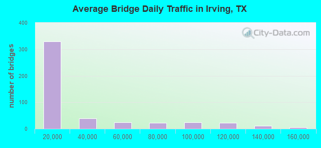
- 13,886,310Total average daily traffic
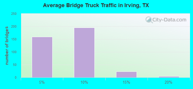
- 835,827Total average daily truck traffic
- National Bridge Inventory (NBI) Registered Bridges for Irving
- No street view available for this location
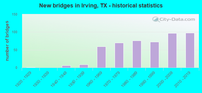
- New bridges - historical statistics
- 11920-1929
- 61940-1949
- 91950-1959
- 591960-1969
- 701970-1979
- 761980-1989
- 721990-1999
- 972000-2009
- 982010-2019
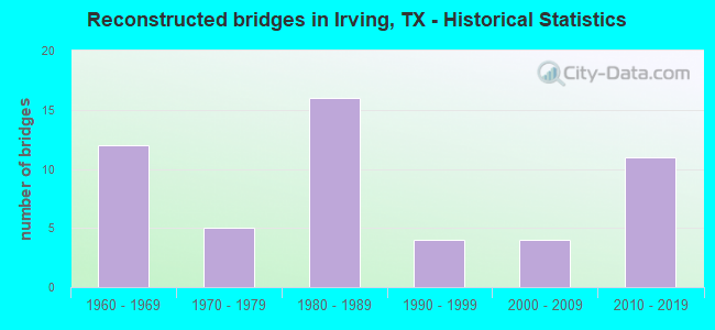
- Reconstructed bridges - Historical Statistics
- 121960-1969
- 51970-1979
- 161980-1989
- 41990-1999
- 42000-2009
- 112010-2019
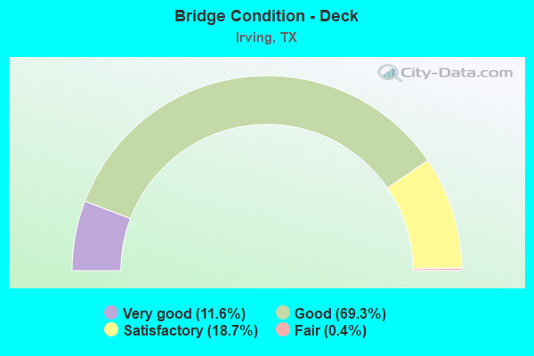
- Bridge Condition - Deck
- 11.6%Very good
- 69.3%Good
- 18.7%Satisfactory
- 0.4%Fair
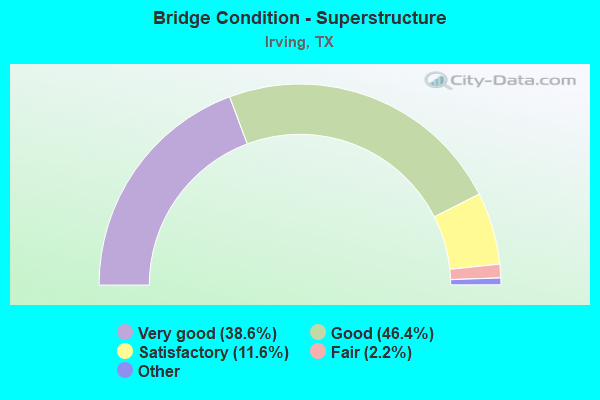
- Bridge Condition - Superstructure
- 38.6%Excellent
- 46.4%Very good
- 11.6%Good
- 2.2%Satisfactory
- 1.1%Fair
- 0.7%Poor
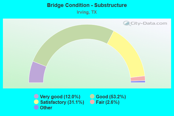
- Bridge Condition - Substructure
- 12.0%Excellent
- 53.2%Very good
- 31.1%Good
- 2.6%Satisfactory
- 1.1%Fair
- 0.4%Poor
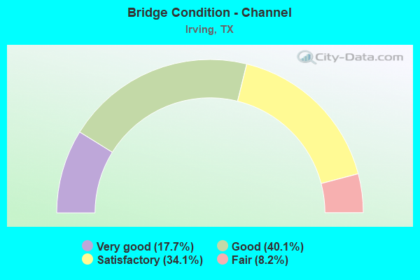
- Bridge Condition - Channel
- 17.7%Very good
- 40.1%Good
- 34.1%Satisfactory
- 8.2%Fair
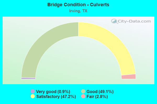
- Bridge Condition - Culverts
- 0.9%Very good
- 49.1%Good
- 47.2%Satisfactory
- 2.8%Fair
Find on map >> Show street view
Structure Number: 180570296401008, Location: 4.60 MI SW OF SH 114 (Lat: 32.845358, Lng: -97.016203), Route carried "under" structure: State highway 161, Year Built: 1993, Structure Length: 0. m, Average Daily Traffic: 105,520 (year 2013), Truck Traffic: 6%, Features Intersected: SH 161, Facility Carried by Structure: ROCHELLE BLVD WB
Minimum Vertical Clearance: 5.59m (18.34ft), Kilometerpoint: 25.577, Lanes on structure: 9, Material/Design: Prestressed concrete, Design/Construction: Stringer/Multi-beam, Length of Maximum Span: 27.4m (89.9ft)
Find on map >> Show street view
Structure Number: 180570296401014, Location: 2.90 MI SW OF SH 114 (Lat: 32.865906, Lng: -97.003411), Route carried "under" structure: State highway 161, Year Built: 1992, Structure Length: 0. m, Average Daily Traffic: 105,520 (year 2013), Truck Traffic: 6%, Features Intersected: SH 161, Facility Carried by Structure: WALNUT HILL EB
Minimum Vertical Clearance: 7.85m (25.75ft), Kilometerpoint: 22.819, Lanes on structure: 6, Material/Design: Prestressed concrete, Design/Construction: Stringer/Multi-beam, Length of Maximum Span: 33.5m (109.9ft)
Find on map >> Show street view
Structure Number: 180570296401015, Location: 2.90 MI SW OF SH 114 (Lat: 32.865908, Lng: -97.002011), Route carried "under" structure: State highway 161, Year Built: 1992, Structure Length: 0. m, Average Daily Traffic: 105,520 (year 2013), Truck Traffic: 6%, Features Intersected: SH 161, Facility Carried by Structure: WALNUT HILL WB
Minimum Vertical Clearance: 7.34m (24.08ft), Kilometerpoint: 22.827, Lanes on structure: 6, Material/Design: Prestressed concrete, Design/Construction: Stringer/Multi-beam, Length of Maximum Span: 33.5m (109.9ft)
Find on map >> Show street view
Structure Number: 180570296401016, Location: 3.75 MI SW OF SH 114 (Lat: 32.856956, Lng: -97.013678), Route carried "under" structure: State highway 161, Year Built: 1992, Structure Length: 0. m, Average Daily Traffic: 105,520 (year 2013), Truck Traffic: 6%, Features Intersected: SH 161, Facility Carried by Structure: NORTHGATE DR EB
Minimum Vertical Clearance: 7.22m (23.69ft), Kilometerpoint: 24.209, Lanes on structure: 8, Material/Design: Prestressed concrete, Design/Construction: Stringer/Multi-beam, Length of Maximum Span: 39.0m (128.0ft)
Find on map >> Show street view
Structure Number: 180570296401017, Location: 3.75 MI SW OF SH 114 (Lat: 32.857222, Lng: -97.012492), Route carried "under" structure: State highway 161, Year Built: 1992, Structure Length: 0. m, Average Daily Traffic: 105,520 (year 2013), Truck Traffic: 6%, Features Intersected: SH 161, Facility Carried by Structure: NORTHGATE DR WB
Minimum Vertical Clearance: 5.56m (18.24ft), Kilometerpoint: 24.201, Lanes on structure: 8, Material/Design: Prestressed concrete, Design/Construction: Stringer/Multi-beam, Length of Maximum Span: 39.0m (128.0ft)
Find on map >> Show street view
Structure Number: 180570296401041, Location: 0.25 MI NE OF SH 114 (Lat: 32.897739, Lng: -96.967936), Route carried "under" structure: City street , Year Built: 1993, Structure Length: 0. m, Average Daily Traffic: 5,400 (year 2016), Features Intersected: W ROYAL LANE, Facility Carried by Structure: SH 161 NBFR PGBT
Minimum Vertical Clearance: 5.49m (18.01ft), Kilometerpoint: 6.614, Lanes on structure: 6, Material/Design: Prestressed concrete, Design/Construction: Stringer/Multi-beam, Length of Maximum Span: 32.0m (105.0ft)
Find on map >> Show street view
Structure Number: 180570296401042, Location: 0.25 MI NE OF SH 114 (Lat: 32.898625, Lng: -96.968681), Route carried "under" structure: City street , Year Built: 1993, Structure Length: 0. m, Average Daily Traffic: 5,400 (year 2016), Features Intersected: W ROYAL LANE, Facility Carried by Structure: SH 161 SBFR PGBT
Minimum Vertical Clearance: 5.13m (16.83ft), Kilometerpoint: 6.502, Lanes on structure: 6, Material/Design: Prestressed concrete, Design/Construction: Stringer/Multi-beam, Length of Maximum Span: 32.0m (105.0ft)
Find on map >> Show street view
Structure Number: 180570296401063, Location: 1.70 MI SW OF SH 114 (Lat: 32.878167, Lng: -96.991681), Route carried "under" structure: State highway 161, Year Built: 1992, Structure Length: 0. m, Average Daily Traffic: 37,960 (year 2013), Truck Traffic: 4%, Features Intersected: SH 161, Facility Carried by Structure: BELT LINE RD SB
Minimum Vertical Clearance: 5.41m (17.75ft), Kilometerpoint: 21.147, Lanes on structure: 6, Material/Design: Steel continuous, Design/Construction: Stringer/Multi-beam, Length of Maximum Span: 51.8m (169.9ft)
Find on map >> Show street view
Structure Number: 180570296401064, Location: 1.70 MI SW OF SH 114 (Lat: 32.877092, Lng: -96.991369), Route carried "under" structure: State highway 161, Year Built: 1992, Structure Length: 0. m, Average Daily Traffic: 93,550 (year 2011), Features Intersected: SH 161, Facility Carried by Structure: BELT LINE RD NB
Minimum Vertical Clearance: 5.74m (18.83ft), Kilometerpoint: 21.131, Lanes on structure: 6, Material/Design: Steel continuous, Design/Construction: Stringer/Multi-beam, Length of Maximum Span: 51.8m (169.9ft)
Find on map >> Show street view
Structure Number: 180570296401114, Location: SH 161 & SH 183 INTERCHGE (Lat: 32.840275, Lng: -97.017128), Route carried "under" structure: ServiceState highway 183, Year Built: 1999, Structure Length: 0. m, Average Daily Traffic: 1,200 (year 2015), Features Intersected: SH 183 WBFR, Facility Carried by Structure: SH 161 CONN C
Minimum Vertical Clearance: 5.97m (19.59ft), Kilometerpoint: 3.500, Lanes on structure: 3, Material/Design: Prestressed concrete, Design/Construction: Stringer/Multi-beam, Length of Maximum Span: 36.6m (120.1ft)
Find on map >> Show street view
Structure Number: 180570296401115, Location: SH 161 & SH 183 INTERCHGE (Lat: 32.843236, Lng: -97.017383), Route carried "under" structure: State highway 161, Year Built: 1999, Structure Length: 0. m, Average Daily Traffic: 98,000 (year 2016), Truck Traffic: 7%, Features Intersected: SH 161
Minimum Vertical Clearance: 9.14m (29.99ft), Kilometerpoint: 26.329, Lanes on structure: 6, Material/Design: Steel continuous, Design/Construction: Stringer/Multi-beam, Length of Maximum Span: 69.8m (229.0ft)
Find on map >> Show street view
Structure Number: 180570296401116, Location: SH 161 & SH 183 INTERCHGE (Lat: 32.836606, Lng: -97.020225), Route carried "under" structure: State highway 161, Year Built: 1999, Structure Length: 0. m, Average Daily Traffic: 98,000 (year 2016), Truck Traffic: 7%, Features Intersected: SH 161, Facility Carried by Structure: SH 183 EB CONN F
Minimum Vertical Clearance: 5.33m (17.49ft), Kilometerpoint: 26.458, Lanes on structure: 6, Material/Design: Steel continuous, Design/Construction: Stringer/Multi-beam, Length of Maximum Span: 63.7m (209.0ft)
Find on map >> Show street view
Structure Number: 180570296401117, Location: SH 161 & SH 183 I/C (Lat: 32.837461, Lng: -97.019089), Route carried "under" structure: Ramp State highway 183, Year Built: 1999, Structure Length: 0. m, Average Daily Traffic: 4,000 (year 2016), Truck Traffic: 2%, Features Intersected: SH 183 WB CONN B, Facility Carried by Structure: SH 161 TURNAROUND
Minimum Vertical Clearance: 5.05m (16.57ft), Kilometerpoint: 3.315, Lanes on structure: 1, Material/Design: Steel, Design/Construction: Stringer/Multi-beam, Length of Maximum Span: 19.8m (65.0ft)
Find on map >> Show street view
Structure Number: 180570296401419, Location: 1.00 MI NE OF SH 114 (Lat: 32.903953, Lng: -96.959022), Route carried "under" structure: Other road 161, Year Built: 2000, Structure Length: 0. m, Average Daily Traffic: 10,000 (year 2011), Features Intersected: SH 161, Facility Carried by Structure: MACARTHUR BLVD SB
Minimum Vertical Clearance: 5.79m (19.00ft), Kilometerpoint: 17.003, Lanes on structure: 8, Toll: On toll road, Material/Design: Steel continuous, Design/Construction: Stringer/Multi-beam, Length of Maximum Span: 41.1m (134.8ft)
Find on map >> Show street view
Structure Number: 18057029640142, Location: 1.00 MI NE OF SH 114 (Lat: 32.905031, Lng: -96.958469), Route carried "under" structure: Other road 161, Year Built: 2000, Structure Length: 0. m, Average Daily Traffic: 10,000 (year 2011), Features Intersected: SH 161, Facility Carried by Structure: MACARTHUR BLVD NB
Minimum Vertical Clearance: 5.56m (18.24ft), Kilometerpoint: 17.003, Lanes on structure: 8, Toll: On toll road, Material/Design: Steel continuous, Design/Construction: Stringer/Multi-beam, Length of Maximum Span: 41.1m (134.8ft)
Find on map >> Show street view
Structure Number: 180570296401421, Location: 1.43 MI NE OF SH 114 (Lat: 32.908358, Lng: -96.953294), Route carried "under" structure: Other road 161, Year Built: 2000, Structure Length: 0. m, Average Daily Traffic: 10,000 (year 2011), Features Intersected: SH 161, Facility Carried by Structure: LAS COLINAS BLV SB
Minimum Vertical Clearance: 6.12m (20.08ft), Kilometerpoint: 15.876, Lanes on structure: 7, Toll: On toll road, Material/Design: Prestressed concrete, Design/Construction: Stringer/Multi-beam, Length of Maximum Span: 32.6m (107.0ft)
Find on map >> Show street view
Structure Number: 180570296401422, Location: 1.43 MI NE OF SH 114 (Lat: 32.908181, Lng: -96.952344), Route carried "under" structure: Other road 161, Year Built: 2000, Structure Length: 0. m, Average Daily Traffic: 10,000 (year 2011), Features Intersected: SH 161, Facility Carried by Structure: LAS COLINAS BLV NB
Minimum Vertical Clearance: 5.84m (19.16ft), Kilometerpoint: 15.876, Lanes on structure: 7, Toll: On toll road, Material/Design: Prestressed concrete, Design/Construction: Stringer/Multi-beam, Length of Maximum Span: 32.6m (107.0ft)
Find on map >> Show street view
Structure Number: 180570296401457, Location: SH 161 & SH 183 INTERCHG (Lat: 32.833389, Lng: -97.016528), Route carried "under" structure: State highway 183, Year Built: 2007, Structure Length: 0. m, Average Daily Traffic: 27,438 (year 2016), Truck Traffic: 13%, Features Intersected: SH 183, Facility Carried by Structure: SH 161 NBML
Minimum Vertical Clearance: 4.93m (16.17ft), Kilometerpoint: 3.203, Lanes on structure: 14, Material/Design: Prestressed concrete, Design/Construction: Stringer/Multi-beam, Length of Maximum Span: 36.6m (120.1ft)
Find on map >> Show street view
Structure Number: 180570296401458, Location: SH 161 & SH 183 INTERCHG (Lat: 32.840278, Lng: -97.017056), Route carried "under" structure: State highway 183, Year Built: 2007, Structure Length: 0. m, Average Daily Traffic: 27,438 (year 2016), Truck Traffic: 13%, Features Intersected: SH 183, Facility Carried by Structure: SH 161 SBML
Minimum Vertical Clearance: 5.66m (18.57ft), Kilometerpoint: 3.187, Lanes on structure: 14, Material/Design: Prestressed concrete, Design/Construction: Stringer/Multi-beam, Length of Maximum Span: 36.6m (120.1ft)
Find on map >> Show street view
Structure Number: 180570296401459, Location: SH 161 & SH 183 INTERCHG (Lat: 32.833417, Lng: -97.016417), Route carried "under" structure: ServiceState highway 183, Year Built: 2007, Structure Length: 0. m, Average Daily Traffic: 4,920 (year 2016), Truck Traffic: 5%, Features Intersected: SH 183 EBFR, Facility Carried by Structure: SH 161 CONN A
Minimum Vertical Clearance: 7.04m (23.10ft), Kilometerpoint: 3.090, Lanes on structure: 2, Material/Design: Prestressed concrete, Design/Construction: Stringer/Multi-beam, Length of Maximum Span: 33.5m (109.9ft)
Find on map >> Show street view
Structure Number: 18057029640146, Location: SH 161 & SH 183 INTERCHG (Lat: 32.836500, Lng: -97.020194), Route carried "under" structure: ServiceState highway 183, Year Built: 2007, Structure Length: 0. m, Average Daily Traffic: 4,920 (year 2016), Truck Traffic: 5%, Features Intersected: SH 183 EBFR
Minimum Vertical Clearance: 9.25m (30.35ft), Kilometerpoint: 2.800, Lanes on structure: 1, Material/Design: Steel continuous, Design/Construction: Stringer/Multi-beam, Length of Maximum Span: 45.7m (149.9ft)
Find on map >> Show street view
Structure Number: 180570296401461, Location: SH 161 & SH 183 INTERCHG (Lat: 32.832611, Lng: -97.015889), Route carried "under" structure: State highway 183, Year Built: 2007, Structure Length: 0. m, Average Daily Traffic: 65,620 (year 2016), Truck Traffic: 13%, Features Intersected: SH 183, Facility Carried by Structure: SH 161 NB CONN G
Minimum Vertical Clearance: 9.14m (29.99ft), Kilometerpoint: 2.655, Lanes on structure: 21, Material/Design: Steel continuous, Design/Construction: Stringer/Multi-beam, Length of Maximum Span: 74.7m (245.1ft)
Find on map >> Show street view
Structure Number: 180570296401462, Location: SH 161 & SH 183 INTERCHG (Lat: 32.837556, Lng: -97.012467), Route carried "under" structure: Other road 161, Year Built: 2007, Structure Length: 0. m, Average Daily Traffic: 15,300 (year 2016), Features Intersected: SH 161, Facility Carried by Structure: SH 183 EB CONN H
Minimum Vertical Clearance: 5.18m (16.99ft), Kilometerpoint: 24.526, Lanes on structure: 16, Toll: On toll road, Material/Design: Steel continuous, Design/Construction: Stringer/Multi-beam, Length of Maximum Span: 67.1m (220.1ft)
Find on map >> Show street view
Structure Number: 180570296401483, Location: 1.40 MI SOUTH OF SH 183 (Lat: 32.825528, Lng: -97.017583), Route carried "under" structure: City street , Year Built: 2009, Structure Length: 0. m, Average Daily Traffic: 5,839 (year 2016), Truck Traffic: 13%, Features Intersected: ROCK ISL AND RDBEAR CR, Facility Carried by Structure: SH 161 SB ML
Minimum Vertical Clearance: 5.39m (17.68ft), Kilometerpoint: 0.000, Lanes on structure: 9, Material/Design: Prestressed concrete, Design/Construction: Stringer/Multi-beam, Length of Maximum Span: 46.6m (152.9ft)
Find on map >> Show street view
Structure Number: 180570296401564, Location: 0.65 MI SW OF SH 114 (Lat: 32.889717, Lng: -96.980786), Route carried "under" structure: City street , Year Built: 2001, Structure Length: 0. m, Average Daily Traffic: 2,500 (year 2011), Truck Traffic: 1%, Features Intersected: GATEWAY DRIVE, Facility Carried by Structure: PGBT NBML
Minimum Vertical Clearance: 5.56m (18.24ft), Kilometerpoint: 19.497, Lanes on structure: 8, Material/Design: Prestressed concrete, Design/Construction: Stringer/Multi-beam, Length of Maximum Span: 27.4m (89.9ft)
Find on map >> Show street view
Structure Number: 180570296401565, Location: 0.65 MI SW OF SH 114 (Lat: 32.890050, Lng: -96.981136), Route carried "under" structure: City street , Year Built: 2001, Structure Length: 0. m, Average Daily Traffic: 2,500 (year 2011), Truck Traffic: 1%, Features Intersected: GATEWAY DRIVE, Facility Carried by Structure: PGBT SBML
Minimum Vertical Clearance: 5.54m (18.18ft), Kilometerpoint: 19.497, Lanes on structure: 8, Material/Design: Prestressed concrete, Design/Construction: Stringer/Multi-beam, Length of Maximum Span: 27.4m (89.9ft)
Find on map >> Show street view
Structure Number: 180570296401566, Location: 0.25 MI NE OF SH 114 (Lat: 32.897903, Lng: -96.968072), Route carried "under" structure: City street , Year Built: 2001, Structure Length: 0. m, Average Daily Traffic: 15,000 (year 2016), Features Intersected: W ROYAL LANE, Facility Carried by Structure: PGBT NB OFF-RP
Minimum Vertical Clearance: 6.17m (20.24ft), Kilometerpoint: 6.598, Lanes on structure: 6, Material/Design: Prestressed concrete, Design/Construction: Stringer/Multi-beam, Length of Maximum Span: 32.0m (105.0ft)
Find on map >> Show street view
Structure Number: 180570296401567, Location: 0.25 MI NE OF SH 114 (Lat: 32.898008, Lng: -96.968172), Route carried "under" structure: City street , Year Built: 2001, Structure Length: 0. m, Average Daily Traffic: 10,000 (year 2016), Features Intersected: W ROYAL LANE, Facility Carried by Structure: PGBT NBML
Minimum Vertical Clearance: 6.38m (20.93ft), Kilometerpoint: 6.566, Lanes on structure: 6, Material/Design: Prestressed concrete, Design/Construction: Stringer/Multi-beam, Length of Maximum Span: 32.0m (105.0ft)
Find on map >> Show street view
Structure Number: 180570296401568, Location: 0.25 MI NE OF SH 114 (Lat: 32.898314, Lng: -96.968425), Route carried "under" structure: City street , Year Built: 2001, Structure Length: 0. m, Average Daily Traffic: 15,000 (year 2016), Features Intersected: W ROYAL LANE, Facility Carried by Structure: PGBT SBML
Minimum Vertical Clearance: 5.79m (19.00ft), Kilometerpoint: 6.534, Lanes on structure: 6, Material/Design: Prestressed concrete, Design/Construction: Stringer/Multi-beam, Length of Maximum Span: 32.0m (105.0ft)
Find on map >> Show street view
Structure Number: 180570296402575, Location: IH 635 @ SH 190 (Lat: 32.912514, Lng: -96.948306), Route carried "under" structure: Interstate 635, Year Built: 2006, Structure Length: 0. m, Average Daily Traffic: 10,000 (year 2011), Truck Traffic: 2%, Features Intersected: IH 635 & SH 190
Minimum Vertical Clearance: 5.49m (18.01ft), Kilometerpoint: 76.721, Lanes on structure: 1, Lanes under structure: 26, Material/Design: Steel continuous, Design/Construction: Stringer/Multi-beam, Length of Maximum Span: 68.9m (226.0ft)
Structure Number: 180570296402576, Location: At SH 190 & IH 635, Route carried "under" structure: Ramp Interstate 635, Year Built: 2006, Structure Length: 0. m, Average Daily Traffic: 8,000 (year 2011), Truck Traffic: 2%, Features Intersected: IH635WBFR & Valley Ranch
Minimum Vertical Clearance: 4.85m (15.91ft), Kilometerpoint: 3.739, Lanes on structure: 1, Lanes under structure: 6, Material/Design: Prestressed concrete, Design/Construction: Stringer/Multi-beam, Length of Maximum Span: 36.6m (120.1ft)
Minimum Vertical Clearance: 4.85m (15.91ft), Kilometerpoint: 3.739, Lanes on structure: 1, Lanes under structure: 6, Material/Design: Prestressed concrete, Design/Construction: Stringer/Multi-beam, Length of Maximum Span: 36.6m (120.1ft)
Find on map >> Show street view
Structure Number: 180570LN2250001, Location: 0.2 Mi S of S Airfield Dr (Lat: 32.859381, Lng: -97.031183), Route carried "under" structure: City street , Year Built: 1999, Structure Length: 0. m, Average Daily Traffic: 3,300 (year 2019), Truck Traffic: 3%, Features Intersected: Passport Ave, Facility Carried by Structure: E 37th St
Minimum Vertical Clearance: 4.55m (14.93ft), Kilometerpoint: 0.322, Lanes on structure: 2, Lanes under structure: 5, Material/Design: Prestressed concrete, Design/Construction: Stringer/Multi-beam, Length of Maximum Span: 23.5m (77.1ft)
Find on map >> Show street view
Structure Number: 180570LN2958003, Location: 0.4 Mi S of S Airfield Dr (Lat: 32.855939, Lng: -97.032550), Route carried "under" structure: City street , Year Built: 1999, Structure Length: 0. m, Average Daily Traffic: 3,300 (year 2019), Truck Traffic: 3%, Features Intersected: Passport Ave, Facility Carried by Structure: S Garage Dr
Minimum Vertical Clearance: 5.11m (16.77ft), Kilometerpoint: 0.644, Lanes on structure: 2, Lanes under structure: 4, Material/Design: Prestressed concrete, Design/Construction: Stringer/Multi-beam, Length of Maximum Span: 16.2m (53.1ft)