Bridge Statistics for Italy, Texas (TX)
Condition, Traffic, Stress, Structural Evaluation, Project Costs
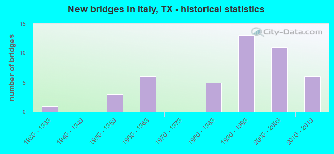
- New bridges - historical statistics
- 11930-1939
- 31950-1959
- 61960-1969
- 51980-1989
- 131990-1999
- 112000-2009
- 62010-2019
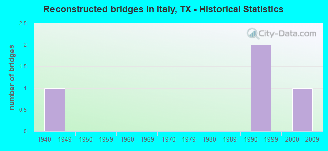
- Reconstructed bridges - Historical Statistics
- 11940-1949
- 01950-1959
- 01960-1969
- 01970-1979
- 01980-1989
- 21990-1999
- 12000-2009
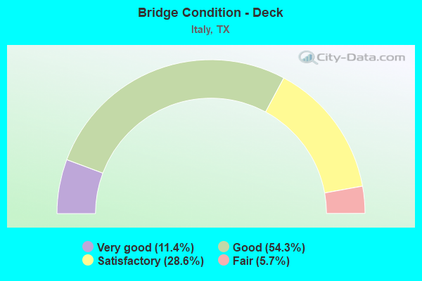
- Bridge Condition - Deck
- 11.4%Very good
- 54.3%Good
- 28.6%Satisfactory
- 5.7%Fair
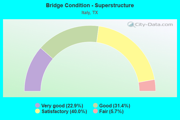
- Bridge Condition - Superstructure
- 22.9%Very good
- 31.4%Good
- 40.0%Satisfactory
- 5.7%Fair
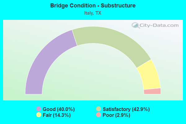
- Bridge Condition - Substructure
- 40.0%Good
- 42.9%Satisfactory
- 14.3%Fair
- 2.9%Poor
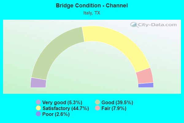
- Bridge Condition - Channel
- 5.3%Very good
- 39.5%Good
- 44.7%Satisfactory
- 7.9%Fair
- 2.6%Poor
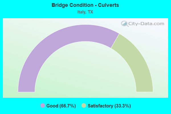
- Bridge Condition - Culverts
- 66.7%Good
- 33.3%Satisfactory
Find on map >> Show street view
Structure Number: 180710004808066, Location: 8.9 MI S OF FM 66 (Lat: 32.246422, Lng: -96.875569), Route carried "under" structure: Interstate 35, Year Built: 2010, Structure Length: 0. m, Average Daily Traffic: 30,520 (year 2013), Truck Traffic: 37%, Features Intersected: IH 35E, Facility Carried by Structure: BILL LEWIS (CR319)
Minimum Vertical Clearance: 5.44m (17.85ft), Kilometerpoint: 18.152, Lanes on structure: 2, Lanes under structure: 6, Material/Design: Prestressed concrete, Design/Construction: Stringer/Multi-beam, Length of Maximum Span: 21.3m (69.9ft)
Find on map >> Show street view
Structure Number: 180710004808174, Location: 1.4 MI S OF SH 34 (Lat: 32.177128, Lng: -96.909294), Route carried "under" structure: City street , Year Built: 2007, Structure Length: 0. m, Average Daily Traffic: 2,000 (year 2011), Truck Traffic: 10%, Features Intersected: DERRS CHAPEL RD, Facility Carried by Structure: IH 35E ML'S
Minimum Vertical Clearance: 5.18m (16.99ft), Kilometerpoint: 9.762, Lanes under structure: 2, Material/Design: Prestressed concrete, Design/Construction: Box Beam or Girders - Multiple, Length of Maximum Span: 27.4m (89.9ft)
Find on map >> Show street view
Structure Number: 180710004808181, Location: IH 35E AT SH 34 (Lat: 32.196433, Lng: -96.899325), Route carried "under" structure: State highway 34, Year Built: 2007, Structure Length: 0. m, Average Daily Traffic: 3,800 (year 2011), Truck Traffic: 17%, Features Intersected: SH 34, Facility Carried by Structure: IH 35E ML'S
Minimum Vertical Clearance: 5.26m (17.26ft), Kilometerpoint: 31.783, Lanes on structure: 4, Lanes under structure: 2, Material/Design: Prestressed concrete, Design/Construction: Box Beam or Girders - Multiple, Length of Maximum Span: 30.5m (100.1ft)
Find on map >> Show street view
Structure Number: 180710004808182, Location: 1.8 MI N OF SH 34 (Lat: 32.220433, Lng: -96.887881), Route carried "under" structure: City street , Year Built: 2007, Structure Length: 0. m, Average Daily Traffic: 500 (year 2011), Truck Traffic: 10%, Features Intersected: CHAMBERS DRIVE, Facility Carried by Structure: IH 35E ML'S
Minimum Vertical Clearance: 6.91m (22.67ft), Kilometerpoint: 14.959, Lanes on structure: 4, Lanes under structure: 2, Material/Design: Prestressed concrete, Design/Construction: Stringer/Multi-beam, Length of Maximum Span: 38.1m (125.0ft)