Bridge Statistics for Jupiter, Florida (FL)
Condition, Traffic, Stress, Structural Evaluation, Project Costs
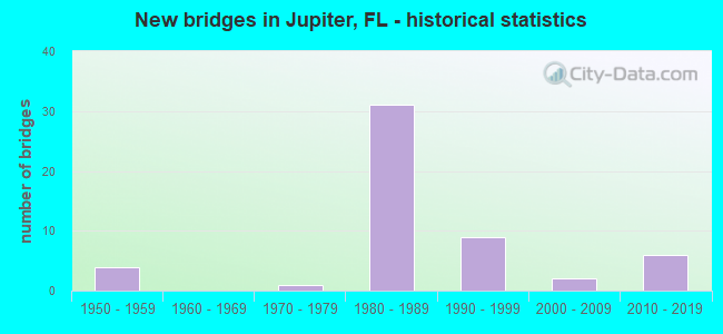
- New bridges - historical statistics
- 41950-1959
- 11970-1979
- 311980-1989
- 91990-1999
- 22000-2009
- 62010-2019
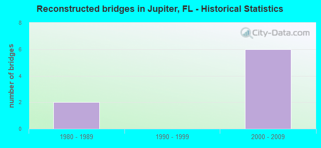
- Reconstructed bridges - Historical Statistics
- 21980-1989
- 01990-1999
- 62000-2009
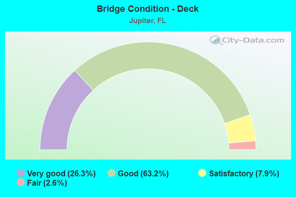
- Bridge Condition - Deck
- 26.3%Very good
- 63.2%Good
- 7.9%Satisfactory
- 2.6%Fair
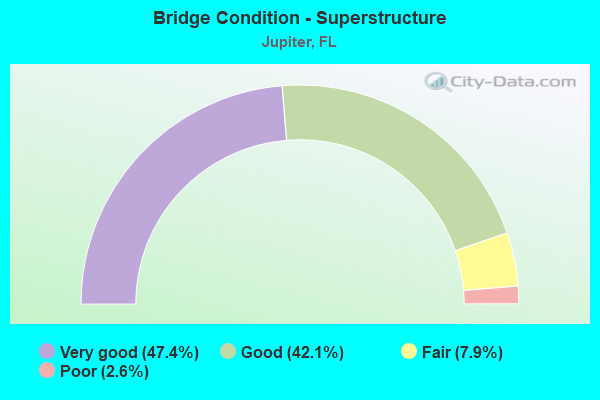
- Bridge Condition - Superstructure
- 47.4%Very good
- 42.1%Good
- 7.9%Fair
- 2.6%Poor
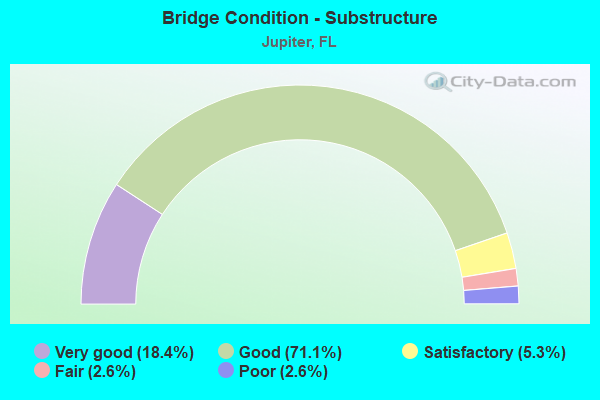
- Bridge Condition - Substructure
- 18.4%Very good
- 71.1%Good
- 5.3%Satisfactory
- 2.6%Fair
- 2.6%Poor
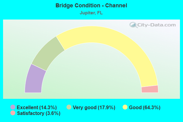
- Bridge Condition - Channel
- 14.3%Excellent
- 17.9%Very good
- 64.3%Good
- 3.6%Satisfactory
Find on map >> Show street view
Structure Number: 930374, Location: Tpk. / SR 706 Interchange (Lat: 26.934758, Lng: -80.153839), Route carried "under" structure: State highway 91, Year Built: 1987, Structure Length: 0. m, Average Daily Traffic: 44,700 (year 2020), Truck Traffic: 16%, Features Intersected: SR-91 (Fla. Turnpike), Facility Carried by Structure: Indiantown Rd.
Minimum Vertical Clearance: 4.96m (16.27ft), Kilometerpoint: 68.865, Lanes on structure: 7, Lanes under structure: 4, Toll: On toll road, Material/Design: Prestressed concrete, Design/Construction: Stringer/Multi-beam, Length of Maximum Span: 35.7m (117.1ft)
Find on map >> Show street view
Structure Number: 930376, Location: I 95 SR 706 interchange (Lat: 26.932750, Lng: -80.151083), Route carried "under" structure: Ramp Interstate 95, Year Built: 1986, Structure Length: 0. m, Average Daily Traffic: 4,800 (year 2021), Truck Traffic: 9%, Features Intersected: SB I-95 To EB 706
Minimum Vertical Clearance: 5.00m (16.40ft), Kilometerpoint: 0.124, Lanes on structure: 2, Lanes under structure: 1, Material/Design: Prestressed concrete, Design/Construction: Stringer/Multi-beam, Length of Maximum Span: 18.4m (60.4ft)
Find on map >> Show street view
Structure Number: 93038, Location: I 95 SR 706 Interchange (Lat: 26.936422, Lng: -80.148253), Route carried "under" structure: Ramp Interstate 95, Year Built: 1987, Structure Length: 0. m, Average Daily Traffic: 8,400 (year 2018), Truck Traffic: 5%, Features Intersected: SR 706 To NB I 95
Minimum Vertical Clearance: 4.94m (16.21ft), Kilometerpoint: 0.262, Lanes on structure: 2, Lanes under structure: 1, Material/Design: Prestressed concrete, Design/Construction: Stringer/Multi-beam, Length of Maximum Span: 37.4m (122.7ft)
Find on map >> Show street view
Structure Number: 930382, Location: I-95 / Donald Ross Rd (Lat: 26.883147, Lng: -80.128603), Route carried "under" structure: County highway , Year Built: 1987, Structure Length: 0. m, Average Daily Traffic: 15,700 (year 2021), Truck Traffic: 5%, Features Intersected: Donald Ross Road, Facility Carried by Structure: SB I-95 ( SR-9 )
Minimum Vertical Clearance: 5.09m (16.70ft), Kilometerpoint: 0.270, Lanes on structure: 5, Lanes under structure: 9, Material/Design: Steel, Design/Construction: Stringer/Multi-beam, Length of Maximum Span: 50.0m (164.0ft)
Find on map >> Show street view
Structure Number: 930383, Location: I-95 / Donald Ross Rd (Lat: 26.882950, Lng: -80.127961), Route carried "under" structure: County highway , Year Built: 1987, Structure Length: 0. m, Average Daily Traffic: 36,000 (year 2021), Truck Traffic: 5%, Features Intersected: Donald Ross Road, Facility Carried by Structure: NB I-95 ( SR-9 )
Minimum Vertical Clearance: 5.09m (16.70ft), Kilometerpoint: 0.322, Lanes on structure: 5, Lanes under structure: 9, Material/Design: Steel, Design/Construction: Stringer/Multi-beam, Length of Maximum Span: 50.0m (164.0ft)
Find on map >> Show street view
Structure Number: 930384, Location: Tpk. SR 706 Interchange (Lat: 26.934358, Lng: -80.153581), Route carried "under" structure: State highway 91, Year Built: 1987, Structure Length: 0. m, Average Daily Traffic: 53,000 (year 2021), Truck Traffic: 11%, Features Intersected: SR-91 Fl. Tpk, Facility Carried by Structure: EB 706 To SB I-95
Minimum Vertical Clearance: 4.98m (16.34ft), Kilometerpoint: 68.832, Lanes on structure: 1, Lanes under structure: 4, Toll: On toll road, Material/Design: Steel continuous, Design/Construction: Stringer/Multi-beam, Length of Maximum Span: 57.5m (188.6ft)
Find on map >> Show street view
Structure Number: 930385, Location: I-95 / SR 706 interchange (Lat: 26.936800, Lng: -80.150175), Route carried "under" structure: Interstate 95, Year Built: 1987, Structure Length: 0. m, Average Daily Traffic: 85,500 (year 2021), Truck Traffic: 8%, Features Intersected: I-95 (SR-9)
Minimum Vertical Clearance: 5.10m (16.73ft), Kilometerpoint: 71.323, Lanes on structure: 2, Lanes under structure: 6, Material/Design: Prestressed concrete, Design/Construction: Stringer/Multi-beam, Length of Maximum Span: 38.5m (126.3ft)
Find on map >> Show street view
Structure Number: 93039, Location: I-95 / SR 706 Interchange (Lat: 26.934539, Lng: -80.151839), Route carried "under" structure: Ramp Interstate 95, Year Built: 1987, Structure Length: 0. m, Average Daily Traffic: 4,600 (year 2021), Truck Traffic: 7%, Features Intersected: SR 706 & I-95/SR706 Ramp
Minimum Vertical Clearance: 7.82m (25.66ft), Kilometerpoint: 0.000, Lanes on structure: 2, Lanes under structure: 1, Material/Design: Prestressed concrete, Design/Construction: Stringer/Multi-beam, Length of Maximum Span: 41.3m (135.5ft)
Find on map >> Show street view
Structure Number: 93039, Location: I-95 / SR 706 Interchange (Lat: 26.934539, Lng: -80.151839), Route carried "under" structure: State highway 706, Year Built: 1987, Structure Length: 0. m, Average Daily Traffic: 68,000 (year 2021), Truck Traffic: 10%, Features Intersected: SR 706 & I-95/SR706 Ramp
Minimum Vertical Clearance: 6.95m (22.80ft), Kilometerpoint: 20.044, Lanes on structure: 2, Lanes under structure: 5, Material/Design: Prestressed concrete, Design/Construction: Stringer/Multi-beam, Length of Maximum Span: 41.3m (135.5ft)
Find on map >> Show street view
Structure Number: 930453, Location: Indiantown Rd./ICW (Lat: 26.933806, Lng: -80.083917), Route carried "under" structure: Business City street , Year Built: 1999, Structure Length: 0. m, Average Daily Traffic: 500 (year 2021), Truck Traffic: 4%, Features Intersected: Intracoastal Waterway, Facility Carried by Structure: EB SR706
Minimum Vertical Clearance: 4.60m (15.09ft), Kilometerpoint: 0.000, Lanes on structure: 3, Lanes under structure: 2, Material/Design: Steel, Design/Construction: Movable - Bascule, Length of Maximum Span: 39.6m (129.9ft)
Find on map >> Show street view
Structure Number: 930454, Location: Indiantown Rd/ ICW (Lat: 26.933981, Lng: -80.083936), Route carried "under" structure: Business City street , Year Built: 1999, Structure Length: 0. m, Average Daily Traffic: 500 (year 2021), Truck Traffic: 5%, Features Intersected: Intracoastal Waterway, Facility Carried by Structure: WB SR 706
Minimum Vertical Clearance: 4.60m (15.09ft), Kilometerpoint: 0.000, Lanes on structure: 3, Lanes under structure: 2, Material/Design: Steel, Design/Construction: Movable - Bascule, Length of Maximum Span: 39.6m (129.9ft)
Find on map >> Show street view
Structure Number: 931012, Location: SR 91 at Jupiter Interch (Lat: 26.939292, Lng: -80.155778), Route carried "under" structure: State highway 91, Year Built: 2012, Structure Length: 0. m, Average Daily Traffic: 42,300 (year 2021), Truck Traffic: 19%, Features Intersected: SR91 TPK (JUPITER INT)
Minimum Vertical Clearance: 5.24m (17.19ft), Kilometerpoint: 69.469, Lanes on structure: 2, Lanes under structure: 5, Toll: On toll road, Material/Design: Prestressed concrete, Design/Construction: Stringer/Multi-beam, Length of Maximum Span: 47.9m (157.2ft)