Bridge Statistics for Kissimmee, Florida (FL)
Condition, Traffic, Stress, Structural Evaluation, Project Costs
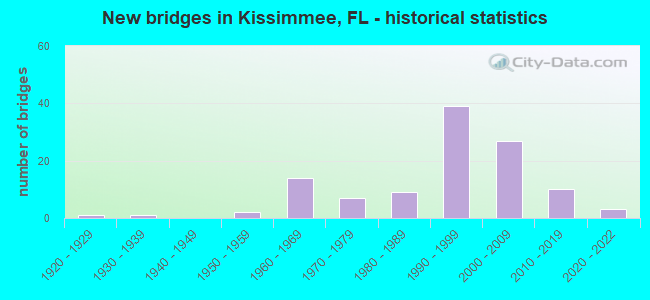
- New bridges - historical statistics
- 11920-1929
- 11930-1939
- 21950-1959
- 141960-1969
- 71970-1979
- 91980-1989
- 391990-1999
- 272000-2009
- 102010-2019
- 32020-2022

- Reconstructed bridges - Historical Statistics
- 11950-1959
- 11960-1969
- 01970-1979
- 21980-1989
- 51990-1999
- 42000-2009


- Bridge Condition - Deck
- 15.2%Very good
- 65.2%Good
- 19.6%Satisfactory

- Bridge Condition - Superstructure
- 13.0%Very good
- 71.7%Good
- 15.2%Satisfactory

- Bridge Condition - Substructure
- 17.4%Very good
- 69.6%Good
- 10.9%Satisfactory
- 2.2%Fair

- Bridge Condition - Channel
- 21.3%Very good
- 55.3%Good
- 19.1%Satisfactory
- 4.3%Fair

- Bridge Condition - Culverts
- 65.5%Good
- 31.0%Satisfactory
- 3.4%Fair
Find on map >> Show street view
Structure Number: 92018, Location: Osceola Pkwy WB over I-4 (Lat: 28.345694, Lng: -81.533364), Route carried "under" structure: Interstate 400, Year Built: 2001, Structure Length: 0. m, Average Daily Traffic: 125,500 (year 2020), Truck Traffic: 9%, Features Intersected: I-4, Facility Carried by Structure: Osceola Parkway WB
Minimum Vertical Clearance: 5.94m (19.49ft), Kilometerpoint: 12.464, Lanes on structure: 4, Lanes under structure: 8, Material/Design: Steel continuous, Design/Construction: Stringer/Multi-beam, Length of Maximum Span: 57.8m (189.6ft)
Find on map >> Show street view
Structure Number: 92018, Location: Osceola Pkwy WB over I-4 (Lat: 28.345694, Lng: -81.533364), Route carried "under" structure: Ramp Interstate 400, Year Built: 2001, Structure Length: 0. m, Average Daily Traffic: 17,500 (year 2020), Truck Traffic: 5%, Features Intersected: I-4, Facility Carried by Structure: Osceola Parkway WB
Minimum Vertical Clearance: 5.18m (16.99ft), Kilometerpoint: 2.099, Lanes on structure: 4, Lanes under structure: 1, Material/Design: Steel continuous, Design/Construction: Stringer/Multi-beam, Length of Maximum Span: 57.8m (189.6ft)
Find on map >> Show street view
Structure Number: 92018, Location: Osceola Pkwy WB over I-4 (Lat: 28.345694, Lng: -81.533364), Route carried "under" structure: Ramp Interstate 400, Year Built: 2001, Structure Length: 0. m, Average Daily Traffic: 17,500 (year 2020), Truck Traffic: 5%, Features Intersected: I-4, Facility Carried by Structure: Osceola Parkway WB
Minimum Vertical Clearance: 5.61m (18.41ft), Kilometerpoint: 2.004, Lanes on structure: 4, Lanes under structure: 1, Material/Design: Steel continuous, Design/Construction: Stringer/Multi-beam, Length of Maximum Span: 57.8m (189.6ft)
Find on map >> Show street view
Structure Number: 920184, Location: RampC2-Osceola Pkwy & C3 (Lat: 28.346211, Lng: -81.529664), Route carried "under" structure: Alternate County highway , Year Built: 2001, Structure Length: 0. m, Average Daily Traffic: 17,500 (year 2020), Truck Traffic: 5%, Features Intersected: Oceola Parkway Ramp C3, Facility Carried by Structure: Ramp C2
Minimum Vertical Clearance: 5.09m (16.70ft), Kilometerpoint: 2.173, Lanes on structure: 1, Lanes under structure: 3, Material/Design: Steel continuous, Design/Construction: Stringer/Multi-beam, Length of Maximum Span: 56.2m (184.4ft)
Find on map >> Show street view
Structure Number: 920184, Location: RampC2-Osceola Pkwy & C3 (Lat: 28.346211, Lng: -81.529664), Route carried "under" structure: Ramp County highway , Year Built: 2001, Structure Length: 0. m, Average Daily Traffic: 17,500 (year 2020), Truck Traffic: 5%, Features Intersected: Oceola Parkway Ramp C3, Facility Carried by Structure: Ramp C2
Minimum Vertical Clearance: 7.56m (24.80ft), Kilometerpoint: 2.253, Lanes on structure: 1, Lanes under structure: 2, Material/Design: Steel continuous, Design/Construction: Stringer/Multi-beam, Length of Maximum Span: 56.2m (184.4ft)
Find on map >> Show street view
Structure Number: 924151, Location: 1.4 Mi. East of US-441 (Lat: 28.341075, Lng: -81.380372), Route carried "under" structure: State highway 91, Year Built: 1987, Structure Length: 0. m, Average Daily Traffic: 71,100 (year 2020), Truck Traffic: 13%, Features Intersected: SR-91 Florida Turnpike, Facility Carried by Structure: Osceola Parkway WB
Minimum Vertical Clearance: 5.55m (18.21ft), Kilometerpoint: 64.744, Lanes on structure: 3, Lanes under structure: 4, Toll: On toll road, Material/Design: Prestressed concrete, Design/Construction: Stringer/Multi-beam, Length of Maximum Span: 23.1m (75.8ft)
Find on map >> Show street view
Structure Number: 924158, Location: Osceola Pwky. EB over I-4 (Lat: 28.345353, Lng: -81.533606), Route carried "under" structure: Ramp Interstate 400, Year Built: 1995, Structure Length: 0. m, Average Daily Traffic: 17,500 (year 2020), Truck Traffic: 5%, Features Intersected: I-4, Facility Carried by Structure: Osceola Pwky EB
Minimum Vertical Clearance: 5.61m (18.41ft), Kilometerpoint: 2.004, Lanes on structure: 8, Lanes under structure: 1, Material/Design: Steel, Design/Construction: Stringer/Multi-beam, Length of Maximum Span: 56.8m (186.4ft)
Find on map >> Show street view
Structure Number: 924158, Location: Osceola Pwky. EB over I-4 (Lat: 28.345353, Lng: -81.533606), Route carried "under" structure: Ramp Interstate 400, Year Built: 1995, Structure Length: 0. m, Average Daily Traffic: 17,500 (year 2020), Truck Traffic: 5%, Features Intersected: I-4, Facility Carried by Structure: Osceola Pwky EB
Minimum Vertical Clearance: 5.18m (16.99ft), Kilometerpoint: 2.099, Lanes on structure: 8, Lanes under structure: 1, Material/Design: Steel, Design/Construction: Stringer/Multi-beam, Length of Maximum Span: 56.8m (186.4ft)
Find on map >> Show street view
Structure Number: 924158, Location: Osceola Pwky. EB over I-4 (Lat: 28.345353, Lng: -81.533606), Route carried "under" structure: Interstate 400, Year Built: 1995, Structure Length: 0. m, Average Daily Traffic: 125,500 (year 2020), Truck Traffic: 9%, Features Intersected: I-4, Facility Carried by Structure: Osceola Pwky EB
Minimum Vertical Clearance: 5.12m (16.80ft), Kilometerpoint: 12.328, Lanes on structure: 8, Lanes under structure: 8, Material/Design: Steel, Design/Construction: Stringer/Multi-beam, Length of Maximum Span: 56.8m (186.4ft)
Find on map >> Show street view
Structure Number: 924171, Location: 1.4 Mi. East of US-441 (Lat: 28.340906, Lng: -81.380347), Route carried "under" structure: State highway 91, Year Built: 1995, Structure Length: 0. m, Average Daily Traffic: 71,100 (year 2020), Truck Traffic: 13%, Features Intersected: SR-91 Florida Turnpike, Facility Carried by Structure: Osceola Parkway EB
Minimum Vertical Clearance: 5.55m (18.21ft), Kilometerpoint: 64.736, Lanes on structure: 5, Lanes under structure: 4, Toll: On toll road, Material/Design: Prestressed concrete, Design/Construction: Stringer/Multi-beam, Length of Maximum Span: 28.6m (93.8ft)
Find on map >> Show street view
Structure Number: 92418, Location: .2 Mi. E of Reunion Blvd. (Lat: 28.269758, Lng: -81.590636), Route carried "under" structure: County highway 545, Year Built: 2005, Structure Length: 0. m, Average Daily Traffic: 2,000 (year 2020), Truck Traffic: 2%, Features Intersected: CR-545, Facility Carried by Structure: Gathering Drive
Minimum Vertical Clearance: 5.00m (16.40ft), Kilometerpoint: 1.104, Lanes on structure: 2, Lanes under structure: 2, Material/Design: Prestressed concrete, Design/Construction: Stringer/Multi-beam, Length of Maximum Span: 38.7m (127.0ft)
Find on map >> Show street view
Structure Number: 924183, Location: 0.9 Mile E of US-192 (Lat: 28.304081, Lng: -81.361906), Route carried "under" structure: Other road 91, Year Built: 2007, Structure Length: 0. m, Average Daily Traffic: 71,100 (year 2020), Truck Traffic: 10%, Features Intersected: Turnpike, Facility Carried by Structure: Fortune Rd EB
Minimum Vertical Clearance: 5.00m (16.40ft), Kilometerpoint: 60.252, Lanes on structure: 2, Lanes under structure: 4, Toll: On toll road, Material/Design: Prestressed concrete, Design/Construction: Stringer/Multi-beam, Length of Maximum Span: 35.1m (115.2ft)
Find on map >> Show street view
Structure Number: 924185, Location: SR91 TPK MP 241.939 (Lat: 28.256056, Lng: -81.331167), Route carried "under" structure: State highway 91, Year Built: 2005, Structure Length: 0. m, Average Daily Traffic: 22,400 (year 2003), Truck Traffic: 7%, Features Intersected: CR-525 242.015, Facility Carried by Structure: Pedestrian Overpas
Minimum Vertical Clearance: 5.58m (18.31ft), Kilometerpoint: 53.892, Lanes under structure: 4, Toll: On toll road, Material/Design: Prestressed concrete, Design/Construction: Stringer/Multi-beam, Length of Maximum Span: 42.1m (138.1ft)
Find on map >> Show street view
Structure Number: 924187, Location: 2.5 Mi North of US-192 (Lat: 28.342433, Lng: -81.419675), Route carried "under" structure: County highway 522, Year Built: 2011, Structure Length: 0. m, Average Daily Traffic: 23,000 (year 2020), Truck Traffic: 6%, Features Intersected: Osceola Parkway (CR-522), Facility Carried by Structure: John Young Parkway
Minimum Vertical Clearance: 5.43m (17.81ft), Kilometerpoint: 13.214, Lanes on structure: 4, Lanes under structure: 4, Material/Design: Steel, Design/Construction: Stringer/Multi-beam, Length of Maximum Span: 63.5m (208.3ft)
Find on map >> Show street view
Structure Number: 924194, Location: B/W Donegan Ave (Lat: 28.311111, Lng: -81.415833), Route carried "under" structure: County highway 525, Year Built: 2016, Structure Length: 0. m, Average Daily Traffic: 44,500 (year 2021), Truck Traffic: 5%, Features Intersected: John Young Parkway, Facility Carried by Structure: Pedestrian Overpas
Minimum Vertical Clearance: 5.64m (18.50ft), Kilometerpoint: 2.242, Lanes under structure: 7, Material/Design: Steel, Design/Construction: Truss - Deck, Length of Maximum Span: 67.1m (220.1ft)
Find on map >> Show street view
Structure Number: 9255, Location: 1.6 Mi. S. of SR-429 (Lat: 28.276033, Lng: -81.598792), Route carried "under" structure: Interstate 400, Year Built: 2005, Structure Length: 0. m, Average Daily Traffic: 125,000 (year 2020), Truck Traffic: 9%, Features Intersected: I-4, Facility Carried by Structure: Tradition Blvd.
Minimum Vertical Clearance: 7.04m (23.10ft), Kilometerpoint: 2.387, Lanes on structure: 2, Lanes under structure: 8, Material/Design: Steel continuous, Design/Construction: Stringer/Multi-beam, Length of Maximum Span: 61.3m (201.1ft)