Bridge Statistics for Kittery, Maine (ME)
Condition, Traffic, Stress, Structural Evaluation, Project Costs
- National Bridge Inventory (NBI) Statistics
- 20Number of bridges
- 367ft / 112mTotal length
- 301,153Total average daily traffic
- 21,070Total average daily truck traffic
- National Bridge Inventory (NBI) Registered Bridges for Kittery
- No street view available for this location
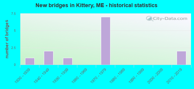
- New bridges - historical statistics
- 11930-1939
- 21940-1949
- 11950-1959
- 71970-1979
- 22010-2019
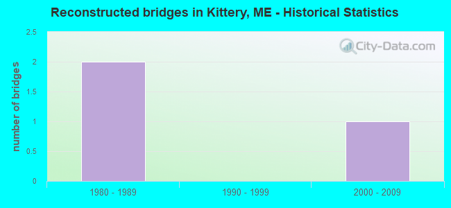
- Reconstructed bridges - Historical Statistics
- 21980-1989
- 01990-1999
- 12000-2009
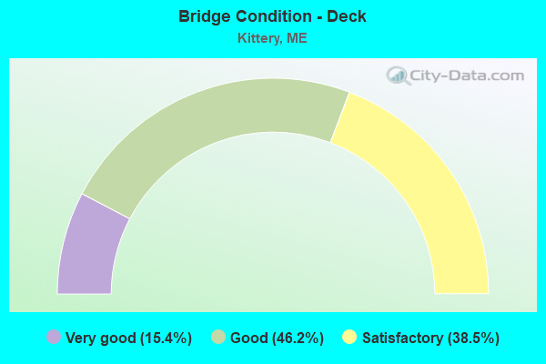
- Bridge Condition - Deck
- 15.4%Very good
- 46.2%Good
- 38.5%Satisfactory
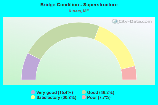
- Bridge Condition - Superstructure
- 15.4%Very good
- 46.2%Good
- 30.8%Satisfactory
- 7.7%Poor
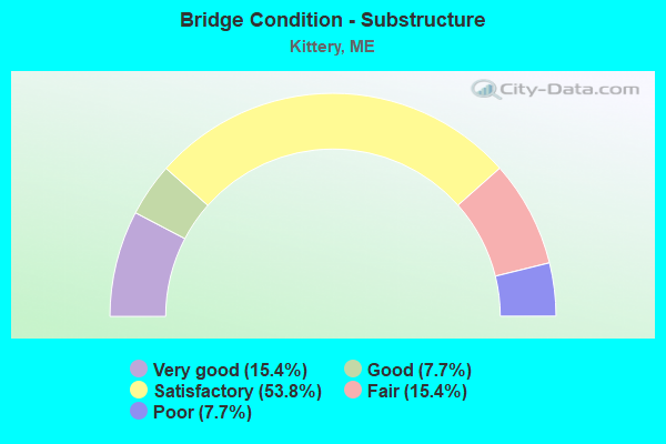
- Bridge Condition - Substructure
- 15.4%Very good
- 7.7%Good
- 53.8%Satisfactory
- 15.4%Fair
- 7.7%Poor
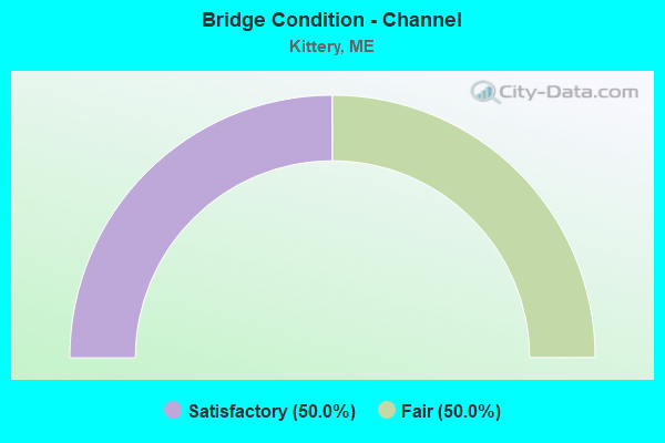
- Bridge Condition - Channel
- 50.0%Satisfactory
- 50.0%Fair
Find on map >> Show street view
Structure Number: 1362, Location: RTE 1 BYPASS (Lat: 43.093139, Lng: -70.753800), Route carried "on" structure: Alternate State highway 1, Year Built: 2010, Status: Open, Structure Length: 2.29m (7.51ft), Average Daily Traffic: 4,293 (year 2016), Truck Traffic: 5%, Average Future Daily Traffic: 6,010 (year 2036), Design Load: HS 25 or greater, Features Intersected: RTE 103
Minimum Vertical Clearance: 30+ m (98+ ft), Kilometerpoint: 0.901, Lanes on structure: 4, Lanes under structure: 2, Base Highway Network: Yes, Owner: State Highway Agency, Approaching Roadway Width: 18.3m (60.0ft), Skew: 23 degrees, Material/Design: Prestressed concrete, Design/Construction: Stringer/Multi-beam, Number Of Spans In Main Unit: 1, Length of Maximum Span: 21.9m (71.9ft), Curb or Sidewalk Widths: Left: 0.5m (1.6ft), Right: 0.5m (1.6ft), Curb-To-Curb Width: 18.7m (61.4ft), Out-to-Out Width: 20.7m (67.9ft)
Condition: Deck: Good, Superstructure: Good, Substructure: Very good, Operating Rating: 46.0 metric tons, Method Used To Determine Operating Rating: Load and Resistance Factor Rating (LRFR) rating reported by rating factor(RF) method using HL-93 loadings, Inventory Rating: 35.3 metric tons, Method Used To Determine Inventory Rating: Load and Resistance Factor Rating (LRFR) rating reported by rating factor(RF) method using HL-93 loadings, Structural Evaluation: Better than present minimum criteria, Deck Geometry: Meets minimum limits, Underclear: High priority of corrective action, Approach Roadway Alignment: Equal to present desirable criteria, Designated Inspection Frequency: Every 24 months, Inspection Date: August 2020, Deck Structure Type: Concrete Cast-file-Place, Wearing Surface/Protective System: Wearing Surface: Bituminous, Membrane: Preformed Fabric
Find on map >> Show street view
Structure Number: 1477, Location: ME SIDE N OF TRUSS END (Lat: 43.095169, Lng: -70.762081), Route carried "on" structure: State highway 95, Year Built: 1972, Status: Open, Structure Length: 40.97m (134.42ft), Average Daily Traffic: 41,190 (year 2016), Truck Traffic: 5%, Average Future Daily Traffic: 57,666 (year 2036), Design Load: HS 20, Features Intersected: Route 103
Minimum Vertical Clearance: 30+ m (98+ ft), Kilometerpoint: 487.502, Lanes on structure: 6, Lanes under structure: 2, Base Highway Network: Yes, Owner: State Highway Agency, Approaching Roadway Width: 15.6m (51.2ft), Skew: 20 degrees, Material/Design: Steel continuous, Design/Construction: Stringer/Multi-beam, Number Of Spans In Main Unit: 14, Length of Maximum Span: 32.9m (107.9ft), Curb or Sidewalk Widths: Left: 0.2m (0.7ft), Right: 0.2m (0.7ft), Curb-To-Curb Width: 30.5m (100.1ft), Out-to-Out Width: 31.7m (104.0ft)
Condition: Deck: Satisfactory, Superstructure: Satisfactory, Substructure: Satisfactory, Operating Rating: 31.8 metric tons, Method Used To Determine Operating Rating: Load and Resistance Factor Rating (LRFR) rating reported by rating factor(RF) method using HL-93 loadings, Inventory Rating: 24.6 metric tons, Method Used To Determine Inventory Rating: Load and Resistance Factor Rating (LRFR) rating reported by rating factor(RF) method using HL-93 loadings, Structural Evaluation: Equal to present minimum criteria, Deck Geometry: Superior to present desirable criteria, Underclear: Somewhat better than minimum adequacy, Approach Roadway Alignment: Equal to present desirable criteria, Designated Inspection Frequency: Every 24 months, Other Special Inspection Frequency: Every 60 months, Inspection Date: May 2021, Other Special Inspection Date: May 2021, Deck Structure Type: Concrete Cast-file-Place, Wearing Surface/Protective System: Wearing Surface: Bituminous, Membrane: Preformed Fabric
Find on map >> Show street view
Structure Number: 2031, Location: .5 MI. N STATELINE (Lat: 43.083361, Lng: -70.751169), Route carried "on" structure: State highway 1, Year Built: 1938, Year Reconstructed: 1986, Status: Open, Structure Length: 15.36m (50.39ft), Average Daily Traffic: 10,523 (year 2016), Truck Traffic: 5%, Average Future Daily Traffic: 14,732 (year 2036), Design Load: H 20, Features Intersected: PISCATAQUA RIVER
Minimum Vertical Clearance: 30+ m (98+ ft), Kilometerpoint: 0.418, Lanes on structure: 2, Base Highway Network: Yes, Owner: State Highway Agency, Approaching Roadway Width: 11.0m (36.1ft), Navigation Control: Yes ( Vertical Clearance: 3.4m (11.2ft), Horizontal Clearance: 29.9m (98.1ft)), Material/Design: Steel continuous, Design/Construction: Stringer/Multi-beam, Number Of Spans In Main Unit: 5, Length of Maximum Span: 33.5m (109.9ft), Curb or Sidewalk Widths: Left: 1.8m (5.9ft), Right: 1.8m (5.9ft), Curb-To-Curb Width: 11.0m (36.1ft), Out-to-Out Width: 15.5m (50.9ft)
Condition: Deck: Satisfactory, Superstructure: Poor, Substructure: Poor, Channel: Fair, Operating Rating: 51.2 metric tons, Method Used To Determine Operating Rating: Load and Resistance Factor Rating (LRFR) rating reported by rating factor(RF) method using HL-93 loadings, Inventory Rating: 39.2 metric tons, Method Used To Determine Inventory Rating: Load and Resistance Factor Rating (LRFR) rating reported by rating factor(RF) method using HL-93 loadings, Structural Evaluation: Meets minimum limits, Deck Geometry: Meets minimum limits, Waterway Adequacy: Superior to present desirable criteria, Approach Roadway Alignment: Equal to present desirable criteria, Designated Inspection Frequency: Every 24 months, Underwater Inspection Frequency: Every 60 months, Inspection Date: April 2021, Underwater Inspection Date: May 2019, Deck Structure Type: Concrete Cast-file-Place, Wearing Surface/Protective System: Wearing Surface: Bituminous, Membrane: Preformed Fabric
Find on map >> Show street view
Structure Number: 386, Location: 1.2 MI NE ME SIDE (Lat: 43.101269, Lng: -70.745219), Route carried "on" structure: Alternate State highway 1, Year Built: 2014, Status: Open, Structure Length: 2.00m (6.56ft), Average Daily Traffic: 2,836 (year 2016), Truck Traffic: 5%, Average Future Daily Traffic: 3,970 (year 2036), Design Load: HL 93, Features Intersected: RTES 1 236
Minimum Vertical Clearance: 30+ m (98+ ft), Kilometerpoint: 2.092, Lanes on structure: 4, Lanes under structure: 2, Base Highway Network: Yes, Owner: State Highway Agency, Approaching Roadway Width: 18.3m (60.0ft), Skew: 21 degrees, Material/Design: Concrete, Design/Construction: Tee Beam, Number Of Spans In Main Unit: 1, Length of Maximum Span: 18.3m (60.0ft), Curb-To-Curb Width: 21.9m (71.9ft), Out-to-Out Width: 23.0m (75.5ft)
Condition: Deck: Very good, Superstructure: Very good, Substructure: Very good, Operating Rating: 65.4 metric tons, Method Used To Determine Operating Rating: Load and Resistance Factor Rating (LRFR) rating reported by rating factor(RF) method using HL-93 loadings, Inventory Rating: 50.5 metric tons, Method Used To Determine Inventory Rating: Load and Resistance Factor Rating (LRFR) rating reported by rating factor(RF) method using HL-93 loadings, Structural Evaluation: Equal to present desirable criteria, Deck Geometry: Better than present minimum criteria, Underclear: High priority of corrective action, Approach Roadway Alignment: Equal to present desirable criteria, Designated Inspection Frequency: Every 24 months, Inspection Date: November 2020, Deck Structure Type: Concrete Cast-file-Place, Wearing Surface/Protective System: Wearing Surface: Bituminous
Find on map >> Show street view
Structure Number: 562, Location: .2 MI W US 1 (Lat: 43.088519, Lng: -70.754031), Route carried "on" structure: State highway 103, Year Built: 1954, Year Reconstructed: 2000, Status: Open, Structure Length: 1.22m (4.00ft), Average Daily Traffic: 9,490 (year 2016), Truck Traffic: 5%, Average Future Daily Traffic: 13,286 (year 2036), Design Load: HS 25 or greater, Features Intersected: B+M SPUR
Minimum Vertical Clearance: 30+ m (98+ ft), Kilometerpoint: 12.601, Lanes on structure: 2, Base Highway Network: Yes, Owner: State Highway Agency, Approaching Roadway Width: 9.8m (32.2ft), Skew: 5 degrees, Material/Design: Concrete, Design/Construction: Slab, Number Of Spans In Main Unit: 1, Length of Maximum Span: 11.0m (36.1ft), Curb or Sidewalk Widths: Left: 0.0m, Right: 1.5m (4.9ft), Curb-To-Curb Width: 9.8m (32.2ft), Out-to-Out Width: 12.1m (39.7ft)
Condition: Deck: Very good, Superstructure: Very good, Substructure: Satisfactory, Operating Rating: 53.1 metric tons, Method Used To Determine Operating Rating: Load and Resistance Factor Rating (LRFR) rating reported by rating factor(RF) method using HL-93 loadings, Inventory Rating: 41.1 metric tons, Method Used To Determine Inventory Rating: Load and Resistance Factor Rating (LRFR) rating reported by rating factor(RF) method using HL-93 loadings, Structural Evaluation: Equal to present minimum criteria, Deck Geometry: Meets minimum limits, Underclear: High priority of corrective action, Approach Roadway Alignment: Equal to present minimum criteria, Designated Inspection Frequency: Every 24 months, Inspection Date: November 2020, Deck Structure Type: Concrete Cast-file-Place, Wearing Surface/Protective System: Wearing Surface: Bituminous, Membrane: Preformed Fabric
Find on map >> Show street view
Structure Number: 6222, Location: 350 FT E OF RAMP H/I95 (Lat: 43.108219, Lng: -70.740981), Route carried "on" structure: State highway 1, Year Built: 1947, Year Reconstructed: 1991, Status: Open, Structure Length: 3.38m (11.09ft), Average Daily Traffic: 9,820 (year 2016), Truck Traffic: 5%, Average Future Daily Traffic: 13,748 (year 2036), Features Intersected: RAMP US 1 TO I-95
Minimum Vertical Clearance: 30+ m (98+ ft), Kilometerpoint: 38.463, Lanes on structure: 2, Lanes under structure: 1, Base Highway Network: Yes, Owner: State Toll Authority, Approaching Roadway Width: 11.3m (37.1ft), Skew: 3 degrees, Material/Design: Steel continuous, Design/Construction: Stringer/Multi-beam, Number Of Spans In Main Unit: 2, Length of Maximum Span: 15.9m (52.2ft), Curb or Sidewalk Widths: Left: 0.2m (0.7ft), Right: 0.2m (0.7ft), Curb-To-Curb Width: 8.7m (28.5ft), Out-to-Out Width: 9.8m (32.2ft)
Condition: Deck: Good, Superstructure: Good, Substructure: Satisfactory, Operating Rating: 44.1 metric tons, Method Used To Determine Operating Rating: Load and Resistance Factor Rating (LRFR) rating reported by rating factor(RF) method using HL-93 loadings, Inventory Rating: 34.0 metric tons, Method Used To Determine Inventory Rating: Load and Resistance Factor Rating (LRFR) rating reported by rating factor(RF) method using HL-93 loadings, Structural Evaluation: Equal to present minimum criteria, Deck Geometry: High priority of corrective action, Underclear: Meets minimum limits, Approach Roadway Alignment: Equal to present desirable criteria, Designated Inspection Frequency: Every 24 months, Inspection Date: May 2021, Deck Structure Type: Concrete Cast-file-Place, Wearing Surface/Protective System: Wearing Surface: Bituminous, Membrane: Preformed Fabric
Find on map >> Show street view
Structure Number: 6223, Location: .1 MI NW US1 (Lat: 43.112539, Lng: -70.737400), Route carried "on" structure: County highway 101, Year Built: 1972, Status: Open, Structure Length: 8.63m (28.31ft), Average Daily Traffic: 4,430 (year 2016), Truck Traffic: 5%, Average Future Daily Traffic: 6,202 (year 2036), Design Load: H 20, Features Intersected: I95, Facility Carried by Structure: WILSON ROAD (ROUTE
Minimum Vertical Clearance: 30+ m (98+ ft), Kilometerpoint: 0.161, Lanes on structure: 2, Lanes under structure: 7, Owner: State Toll Authority, Approaching Roadway Width: 10.4m (34.1ft), Skew: 1 degrees, Material/Design: Steel continuous, Design/Construction: Stringer/Multi-beam, Number Of Spans In Main Unit: 4, Length of Maximum Span: 27.1m (88.9ft), Curb or Sidewalk Widths: Left: 0.2m (0.7ft), Right: 0.2m (0.7ft), Curb-To-Curb Width: 9.2m (30.2ft), Out-to-Out Width: 10.2m (33.5ft)
Condition: Deck: Good, Superstructure: Good, Substructure: Satisfactory, Operating Rating: 45.4 metric tons, Method Used To Determine Operating Rating: Load and Resistance Factor Rating (LRFR) rating reported by rating factor(RF) method using HL-93 loadings, Inventory Rating: 35.0 metric tons, Method Used To Determine Inventory Rating: Load and Resistance Factor Rating (LRFR) rating reported by rating factor(RF) method using HL-93 loadings, Structural Evaluation: Equal to present minimum criteria, Deck Geometry: Meets minimum limits, Underclear: Somewhat better than minimum adequacy, Approach Roadway Alignment: Equal to present desirable criteria, Designated Inspection Frequency: Every 24 months, Inspection Date: May 2021, Deck Structure Type: Concrete Cast-file-Place, Wearing Surface/Protective System: Wearing Surface: Bituminous, Membrane: Built-up
Find on map >> Show street view
Structure Number: 6224, Location: 0.2 MI SW OF YORK TL (Lat: 43.114889, Lng: -70.734131), Route carried "on" structure: Interstate 95, Year Built: 1947, Status: Open, Structure Length: 1.62m (5.31ft), Average Daily Traffic: 31,420 (year 2016), Truck Traffic: 5%, Average Future Daily Traffic: 43,988 (year 2036), Design Load: HS 20, Features Intersected: SPRUCE CREEK
Minimum Vertical Clearance: 30+ m (98+ ft), Kilometerpoint: 3.621, Lanes on structure: 6, Base Highway Network: Yes, Toll: On Interstate toll segment, Owner: State Toll Authority, Approaching Roadway Width: 16.2m (53.1ft), Skew: 20 degrees, Navigation Control: Yes ( Vertical Clearance: 0.6m (2.0ft), Horizontal Clearance: 5.8m (19.0ft)), Material/Design: Steel, Design/Construction: Stringer/Multi-beam, Number Of Spans In Main Unit: 1, Length of Maximum Span: 14.6m (47.9ft), Curb or Sidewalk Widths: Left: 0.2m (0.7ft), Right: 0.2m (0.7ft), Curb-To-Curb Width: 16.8m (55.1ft), Out-to-Out Width: 37.4m (122.7ft)
Condition: Deck: Satisfactory, Superstructure: Good, Substructure: Satisfactory, Channel: Satisfactory, Operating Rating: 45.0 metric tons, Method Used To Determine Operating Rating: Load and Resistance Factor Rating (LRFR) rating reported by rating factor(RF) method using HL-93 loadings, Inventory Rating: 34.7 metric tons, Method Used To Determine Inventory Rating: Load and Resistance Factor Rating (LRFR) rating reported by rating factor(RF) method using HL-93 loadings, Structural Evaluation: Equal to present minimum criteria, Deck Geometry: High priority of replacement, Waterway Adequacy: Better than present minimum criteria, Approach Roadway Alignment: Equal to present desirable criteria, Designated Inspection Frequency: Every 24 months, Inspection Date: May 2021, Deck Structure Type: Concrete Cast-file-Place, Wearing Surface/Protective System: Wearing Surface: Bituminous, Membrane: Preformed Fabric
Find on map >> Show street view
Structure Number: 6225, Location: 0.262 mi NW of US 1 (Lat: 43.123681, Lng: -70.723650), Route carried "on" structure: City street , Year Built: 1978, Status: Open, Structure Length: 7.89m (25.89ft), Average Daily Traffic: 1,970 (year 2016), Truck Traffic: 5%, Average Future Daily Traffic: 2,955 (year 2036), Design Load: HL 93, Features Intersected: I-95, Facility Carried by Structure: CUTTS ROAD
Minimum Vertical Clearance: 30+ m (98+ ft), Kilometerpoint: 0.370, Lanes on structure: 2, Lanes under structure: 6, Owner: State Toll Authority, Approaching Roadway Width: 9.4m (30.8ft), Skew: 3 degrees, Material/Design: Steel continuous, Design/Construction: Stringer/Multi-beam, Number Of Spans In Main Unit: 2, Length of Maximum Span: 40.5m (132.9ft), Curb or Sidewalk Widths: Left: 0.2m (0.7ft), Right: 0.2m (0.7ft), Curb-To-Curb Width: 9.1m (29.9ft), Out-to-Out Width: 10.3m (33.8ft)
Condition: Deck: Good, Superstructure: Satisfactory, Substructure: Good, Operating Rating: 33.4 metric tons, Method Used To Determine Operating Rating: Load and Resistance Factor Rating (LRFR) rating reported by rating factor(RF) method using HL-93 loadings, Inventory Rating: 25.6 metric tons, Method Used To Determine Inventory Rating: Load and Resistance Factor Rating (LRFR) rating reported by rating factor(RF) method using HL-93 loadings, Structural Evaluation: Equal to present minimum criteria, Deck Geometry: Somewhat better than minimum adequacy, Underclear: Somewhat better than minimum adequacy, Approach Roadway Alignment: Equal to present desirable criteria, Designated Inspection Frequency: Every 24 months, Inspection Date: May 2021, Deck Structure Type: Concrete Cast-file-Place, Wearing Surface/Protective System: Membrane: Preformed Fabric
Find on map >> Show street view
Structure Number: 6275, Location: .5 MI N STATELINE (Lat: 43.098300, Lng: -70.756189), Route carried "on" structure: State highway 95, Year Built: 1971, Status: Open, Structure Length: 3.11m (10.20ft), Average Daily Traffic: 40,420 (year 2016), Truck Traffic: 5%, Average Future Daily Traffic: 56,588 (year 2036), Design Load: HS 20+Mod, Features Intersected: DENNETT ROAD
Minimum Vertical Clearance: 30+ m (98+ ft), Kilometerpoint: 0.885, Lanes on structure: 7, Lanes under structure: 2, Base Highway Network: Yes, Owner: State Toll Authority, Approaching Roadway Width: 15.9m (52.2ft), Skew: 22 degrees, Material/Design: Steel, Design/Construction: Stringer/Multi-beam, Number Of Spans In Main Unit: 1, Length of Maximum Span: 29.3m (96.1ft), Curb or Sidewalk Widths: Left: 0.1m (0.3ft), Right: 0.1m (0.3ft), Curb-To-Curb Width: 41.1m (134.8ft), Out-to-Out Width: 43.8m (143.7ft)
Condition: Deck: Good, Superstructure: Satisfactory, Substructure: Satisfactory, Operating Rating: 48.3 metric tons, Method Used To Determine Operating Rating: Load and Resistance Factor Rating (LRFR) rating reported by rating factor(RF) method using HL-93 loadings, Inventory Rating: 37.3 metric tons, Method Used To Determine Inventory Rating: Load and Resistance Factor Rating (LRFR) rating reported by rating factor(RF) method using HL-93 loadings, Structural Evaluation: Equal to present minimum criteria, Deck Geometry: Superior to present desirable criteria, Underclear: Meets minimum limits, Approach Roadway Alignment: Equal to present desirable criteria, Designated Inspection Frequency: Every 24 months, Inspection Date: May 2021, Deck Structure Type: Concrete Cast-file-Place, Wearing Surface/Protective System: Wearing Surface: Bituminous, Membrane: Preformed Fabric
Find on map >> Show street view
Structure Number: 6276, Location: AT I-95 EXIT 2 INTERCH. (Lat: 43.104619, Lng: -70.747689), Route carried "on" structure: State highway 236, Year Built: 1971, Status: Open, Structure Length: 7.65m (25.10ft), Average Daily Traffic: 10,890 (year 2016), Truck Traffic: 5%, Average Future Daily Traffic: 15,246 (year 2036), Design Load: HS 20, Features Intersected: I-95
Minimum Vertical Clearance: 30+ m (98+ ft), Kilometerpoint: 2.205, Lanes on structure: 4, Lanes under structure: 9, Base Highway Network: Yes, Owner: State Toll Authority, Approaching Roadway Width: 28.0m (91.9ft), Skew: 23 degrees, Material/Design: Steel continuous, Design/Construction: Stringer/Multi-beam, Number Of Spans In Main Unit: 3, Length of Maximum Span: 29.9m (98.1ft), Curb or Sidewalk Widths: Left: 0.2m (0.7ft), Right: 0.2m (0.7ft), Curb-To-Curb Width: 27.3m (89.6ft), Out-to-Out Width: 28.4m (93.2ft)
Condition: Deck: Satisfactory, Superstructure: Satisfactory, Substructure: Fair, Operating Rating: 54.4 metric tons, Method Used To Determine Operating Rating: Load and Resistance Factor Rating (LRFR) rating reported by rating factor(RF) method using HL-93 loadings, Inventory Rating: 41.8 metric tons, Method Used To Determine Inventory Rating: Load and Resistance Factor Rating (LRFR) rating reported by rating factor(RF) method using HL-93 loadings, Structural Evaluation: Somewhat better than minimum adequacy, Deck Geometry: Superior to present desirable criteria, Underclear: High priority of corrective action, Approach Roadway Alignment: Equal to present desirable criteria, Designated Inspection Frequency: Every 24 months, Inspection Date: May 2021, Deck Structure Type: Concrete Cast-file-Place, Wearing Surface/Protective System: Wearing Surface: Bituminous, Membrane: Built-up
Find on map >> Show street view
Structure Number: 6277, Location: 250'W OF US1 SOUTH BOUND (Lat: 43.108289, Lng: -70.742819), Route carried "on" structure: Ramp State highway , Year Built: 1971, Status: Open, Structure Length: 6.86m (22.51ft), Average Daily Traffic: 4,730 (year 2016), Truck Traffic: 5%, Average Future Daily Traffic: 6,622 (year 2036), Design Load: HS 20, Features Intersected: I-95, Facility Carried by Structure: RAMP H
Minimum Vertical Clearance: 30+ m (98+ ft), Kilometerpoint: 0.129, Lanes on structure: 1, Lanes under structure: 6, Owner: State Toll Authority, Approaching Roadway Width: 8.5m (27.9ft), Skew: 2 degrees, Material/Design: Steel continuous, Design/Construction: Stringer/Multi-beam, Number Of Spans In Main Unit: 2, Length of Maximum Span: 34.1m (111.9ft), Curb or Sidewalk Widths: Left: 0.2m (0.7ft), Right: 0.2m (0.7ft), Curb-To-Curb Width: 8.2m (26.9ft), Out-to-Out Width: 9.4m (30.8ft)
Condition: Deck: Good, Superstructure: Good, Substructure: Satisfactory, Operating Rating: 54.8 metric tons, Method Used To Determine Operating Rating: Load and Resistance Factor Rating (LRFR) rating reported by rating factor(RF) method using HL-93 loadings, Inventory Rating: 42.4 metric tons, Method Used To Determine Inventory Rating: Load and Resistance Factor Rating (LRFR) rating reported by rating factor(RF) method using HL-93 loadings, Structural Evaluation: Equal to present minimum criteria, Deck Geometry: Superior to present desirable criteria, Underclear: Equal to present minimum criteria, Approach Roadway Alignment: Better than present minimum criteria, Designated Inspection Frequency: Every 24 months, Inspection Date: May 2021, Deck Structure Type: Concrete Cast-file-Place, Wearing Surface/Protective System: Wearing Surface: Bituminous, Membrane: Preformed Fabric
Find on map >> Show street view
Structure Number: 6278, Location: 0.2 MI NE OF I95 NB (Lat: 43.106831, Lng: -70.742050), Route carried "on" structure: Ramp State highway , Year Built: 1972, Status: Open, Structure Length: 10.55m (34.61ft), Average Daily Traffic: 5,420 (year 2016), Truck Traffic: 5%, Average Future Daily Traffic: 7,588 (year 2036), Design Load: HS 20, Features Intersected: BYPASS 1 + RAMP M, Facility Carried by Structure: N.B. RAMP I-95 TO
Minimum Vertical Clearance: 30+ m (98+ ft), Kilometerpoint: 0.563, Lanes on structure: 1, Lanes under structure: 4, Owner: State Toll Authority, Approaching Roadway Width: 8.5m (27.9ft), Skew: 1 degrees, Material/Design: Steel continuous, Design/Construction: Stringer/Multi-beam, Number Of Spans In Main Unit: 4, Length of Maximum Span: 25.9m (85.0ft), Curb or Sidewalk Widths: Left: 0.2m (0.7ft), Right: 0.2m (0.7ft), Curb-To-Curb Width: 8.2m (26.9ft), Out-to-Out Width: 9.4m (30.8ft)
Condition: Deck: Satisfactory, Superstructure: Good, Substructure: Fair, Operating Rating: 44.7 metric tons, Method Used To Determine Operating Rating: Load and Resistance Factor Rating (LRFR) rating reported by rating factor(RF) method using HL-93 loadings, Inventory Rating: 34.3 metric tons, Method Used To Determine Inventory Rating: Load and Resistance Factor Rating (LRFR) rating reported by rating factor(RF) method using HL-93 loadings, Structural Evaluation: Somewhat better than minimum adequacy, Deck Geometry: Superior to present desirable criteria, Underclear: High priority of corrective action, Approach Roadway Alignment: Equal to present desirable criteria, Designated Inspection Frequency: Every 24 months, Inspection Date: May 2021, Deck Structure Type: Concrete Cast-file-Place, Wearing Surface/Protective System: Wearing Surface: Bituminous, Membrane: Built-up
Find on map >> Show street view
Location: 350 FT E OF RAMP H/I95 (Lat: 43.108222, Lng: -70.740981), Route carried "under" structure: Alternate US 22310, Structure Length: 0. m, Average Daily Traffic: 9,641 (year 2014), Truck Traffic: 5%, Features Intersected: SB US 1, Facility Carried by Structure: RAMP US 1 TO I-95
Minimum Vertical Clearance: 4.37m (14.34ft), Kilometerpoint: 38.447, Lanes on structure: 2, Length of Maximum Span: 0.0m
Find on map >> Show street view
Location: .1 MI NW US1 (Lat: 43.112539, Lng: -70.737397), Route carried "under" structure: Alternate US 32310, Structure Length: 0. m, Average Daily Traffic: 28,261 (year 2014), Truck Traffic: 11%, Features Intersected: WILSON ROAD (ROUTE, Facility Carried by Structure: I-95
Minimum Vertical Clearance: 5.03m (16.50ft), Kilometerpoint: 3.235, Lanes on structure: 6, Length of Maximum Span: 0.0m
Find on map >> Show street view
Location: 0.262 mi NW of US 1 (Lat: 43.123681, Lng: -70.723647), Route carried "under" structure: Alternate US 52110, Structure Length: 0. m, Average Daily Traffic: 28,261 (year 2014), Truck Traffic: 11%, Features Intersected: CUTTS ROAD, Facility Carried by Structure: I-95
Minimum Vertical Clearance: 5.41m (17.75ft), Kilometerpoint: 4.925, Lanes on structure: 6, Toll: On Interstate toll segment, Length of Maximum Span: 0.0m
Find on map >> Show street view
Location: .5 MI N STATELINE (Lat: 43.098300, Lng: -70.756189), Route carried "under" structure: Ramp US 52400, Structure Length: 0. m, Average Daily Traffic: 4,998 (year 2014), Truck Traffic: 5%, Features Intersected: I-95, Facility Carried by Structure: DENNETT ROAD
Minimum Vertical Clearance: 4.44m (14.57ft), Kilometerpoint: 1.658, Lanes on structure: 4, Length of Maximum Span: 0.0m
Find on map >> Show street view
Location: AT I-95 EXIT 2 INTERCH. (Lat: 43.104617, Lng: -70.747689), Route carried "under" structure: Ramp US 62310, Structure Length: 0. m, Average Daily Traffic: 24,310 (year 2014), Truck Traffic: 10%, Features Intersected: ROUTE 236, Facility Carried by Structure: I-95
Minimum Vertical Clearance: 5.10m (16.73ft), Kilometerpoint: 1.963, Lanes on structure: 6, Length of Maximum Span: 0.0m
Find on map >> Show street view
Location: 250'W OF US1 SOUTH BOUND (Lat: 43.108283, Lng: -70.742822), Route carried "under" structure: Ramp US 72310, Structure Length: 0. m, Average Daily Traffic: 24,310 (year 2014), Truck Traffic: 10%, Features Intersected: RAMP H, Facility Carried by Structure: I-95
Minimum Vertical Clearance: 5.05m (16.57ft), Kilometerpoint: 2.591, Lanes on structure: 6, Length of Maximum Span: 0.0m
Find on map >> Show street view
Location: 0.2 MI NE OF I95 NB (Lat: 43.106833, Lng: -70.742044), Route carried "under" structure: Ramp US 82370, Structure Length: 0. m, Average Daily Traffic: 3,940 (year 2014), Truck Traffic: 10%, Features Intersected: N.B. RAMP I-95 TO, Facility Carried by Structure: BYPASS 1 + RAMP M
Minimum Vertical Clearance: 4.55m (14.93ft), Kilometerpoint: 0.547, Lanes on structure: 4, Length of Maximum Span: 0.0m