Kittery, Maine

Kittery: Taken at Fort Foster
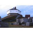
Kittery: Taken at Fort Foster. User comment: This isn't Fort Foster. It is Fort Mclary.
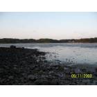
Kittery: Salt Flats leading to the Atlantic Ocean.
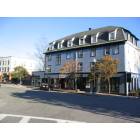
Kittery: Kittery
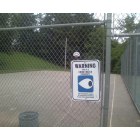
Kittery: Kittery Basketball Courts
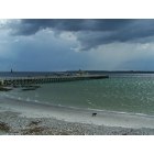
Kittery: The beach at Fort Foster
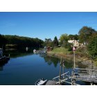
Kittery: Chauncey Creek
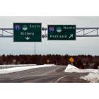
Kittery: I95 in Kittery
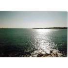
Kittery: The atlantic
- add
your
Submit your own pictures of this place and show them to the world
- OSM Map
- General Map
- Google Map
- MSN Map
Population change since 2000: -6.6%
| Males: 2,178 | |
| Females: 2,384 |
| Median resident age: | 47.0 years |
| Maine median age: | 45.1 years |
Zip codes: 03904.
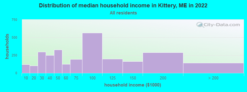
| Kittery: | $69,047 |
| ME: | $69,543 |
Estimated per capita income in 2022: $46,779 (it was $22,451 in 2000)
Kittery CDP income, earnings, and wages data
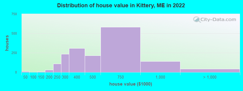
Estimated median house or condo value in 2022: $424,295 (it was $126,800 in 2000)
| Kittery: | $424,295 |
| ME: | $290,600 |
Mean prices in 2022: all housing units: $451,552; detached houses: $470,451; townhouses or other attached units: $577,335; in 2-unit structures: $383,179; in 3-to-4-unit structures: $310,696; in 5-or-more-unit structures: $252,113; mobile homes: $105,501
Median gross rent in 2022: $1,268.
(5.3% for White Non-Hispanic residents, 31.6% for Black residents, 38.2% for Hispanic or Latino residents, 28.9% for other race residents, 56.3% for two or more races residents)
Detailed information about poverty and poor residents in Kittery, ME


Compare current foreclosures near Kittery, ME:
| Photo | Address | Area | Beds / Baths | Price | Details |
|---|---|---|---|---|---|

|
#1
Boush St
Kittery, ME 03904
|
- sq. feet
|
- baths - beds |
show details | |

|
#2
Clayton Ln
Kittery, ME 03904
|
- sq. feet
|
- baths - beds |
show details | |

|
#3
Brentwood Rd
Exeter, NH 03833
|
2,756 sq. feet
|
2 baths 3 beds |
$419,900
|
show details |

|
#4
Smoke St
Nottingham, NH 03290
|
2,681 sq. feet
|
2 baths 3 beds |
show details | |

|
#5
Shore Rd
Cape Neddick, ME 03902
|
1,900 sq. feet
|
1 baths 4 beds |
show details | |

|
#6
Langs Ln
Newmarket, NH 03857
|
2,466 sq. feet
|
2 baths 3 beds |
show details | |

|
#7
Northam Dr
Dover, NH 03820
|
1,999 sq. feet
|
2 baths 3 beds |
show details | |

|
#8
Dearborn Ave
Hampton, NH 03842
|
1,708 sq. feet
|
1 baths 3 beds |
show details | |

|
#9
Harvard St
Exeter, NH 03833
|
1,509 sq. feet
|
1 baths 3 beds |
show details | |

|
#10
Piscassic St
Newmarket, NH 03857
|
1,608 sq. feet
|
2 baths 4 beds |
show details |
| Photo | Address | Area | Beds / Baths | Price | Details |
|---|---|---|---|---|---|

|
#11
Ernest Ave Apt 4
Exeter, NH 03833
|
555 sq. feet
|
1 baths 1 beds |
show details | |

|
#12
Chapel St
Dover, NH 03820
|
1,872 sq. feet
|
2 baths 4 beds |
show details | |

|
#13
Brentwood Rd
Exeter, NH 03833
|
3,683 sq. feet
|
3 baths 4 beds |
show details | |

|
#14
Back River Rd
Dover, NH 03820
|
1,193 sq. feet
|
1 baths 3 beds |
show details | |

|
#15
Plum St
Exeter, NH 03833
|
924 sq. feet
|
1 baths 3 beds |
show details | |

|
#16
Middle Rd
Dover, NH 03820
|
1,120 sq. feet
|
1 baths 3 beds |
show details | |

|
#17
Old Post Rd
York, ME 03909
|
864 sq. feet
|
1 baths 2 beds |
show details | |

|
#18
Del Logan Dr
Salisbury, MA 01952
|
1,986 sq. feet
|
1 baths 3 beds |
show details | |

|
#19
Cedar Point Rd
Durham, NH 03824
|
4,052 sq. feet
|
3 baths 3 beds |
show details | |

|
#20
Adams Park
Rye, NH 03870
|
1,008 sq. feet
|
2 baths 3 beds |
show details |
| Photo | Address | Area | Beds / Baths | Price | Details |
|---|---|---|---|---|---|

|
#21
Wentworth Ter
Dover, NH 03820
|
2,404 sq. feet
|
3 baths 6 beds |
show details | |

|
#22
Old Dover Rd
Rochester, NH 03867
|
- sq. feet
|
1 baths 3 beds |
show details | |

|
#23
Frost Hill Rd, C O Gregory Jackman
Eliot, ME 03903
|
3,472 sq. feet
|
3 baths 4 beds |
show details | |

|
#24
Olde Farm Way
Berwick, ME 03901
|
2,376 sq. feet
|
3 baths - beds |
show details | |

|
#25
Tatnic Rd
Wells, ME 04090
|
2,238 sq. feet
|
2 baths - beds |
show details | |

|
#26
Pine Hill Rd
Berwick, ME 03901
|
2,882 sq. feet
|
2 baths - beds |
show details | |

|
#27
Hall Pl Apt 1
Exeter, NH 03833
|
- sq. feet
|
- baths - beds |
show details | |

|
#28
France Rd
Barrington, NH 03825
|
- sq. feet
|
- baths - beds |
show details | |

|
#29
I St Apt 3
Hampton, NH 03842
|
- sq. feet
|
- baths - beds |
show details | |

|
#30
Beech Hill Rd Lot 18
Exeter, NH 03833
|
- sq. feet
|
- baths - beds |
show details |
| Photo | Address | Area | Beds / Baths | Price | Details |
|---|---|---|---|---|---|

|
#31
New Zealand Rd Apt 24
Seabrook, NH 03874
|
- sq. feet
|
- baths - beds |
show details | |

|
#32
Route 236 Apt F4
Berwick, ME 03901
|
- sq. feet
|
- baths - beds |
show details | |

|
#33
Meadowbrook Road
Nottingham, NH 03290
|
- sq. feet
|
- baths - beds |
show details | |

|
#34
Asteria Ln, Unit 105
Rochester, NH 03867
|
- sq. feet
|
- baths - beds |
show details | |

|
#35
Lafayette Rd # 11
Hampton Falls, NH 03844
|
- sq. feet
|
- baths - beds |
show details | |

|
#36
Drakeside Rd Unit 1302
Hampton, NH 03842
|
- sq. feet
|
- baths - beds |
show details | |

|
#37
Canal St Unit 307
North Berwick, ME 03906
|
- sq. feet
|
- baths - beds |
show details | |

|
#38
Blackberry Hill Rd
Berwick, ME 03901
|
- sq. feet
|
- baths - beds |
show details | |

|
#39
Captains Way
Exeter, NH 03833
|
- sq. feet
|
- baths - beds |
show details | |

|
#40
Holland Way
Exeter, NH 03833
|
15,738 sq. feet
|
- baths - beds |
show details |
| Photo | Address | Area | Beds / Baths | Price | Details |
|---|---|---|---|---|---|

|
#41
1st St, Apt 210-1
Dover, NH 03820
|
- sq. feet
|
- baths - beds |
show details | |

|
#42
Laurel Ln
New Castle, NH 03854
|
- sq. feet
|
- baths - beds |
show details | |

|
#43
Sagamore Ave # 13
Portsmouth, NH 03801
|
- sq. feet
|
- baths - beds |
show details | |

|
#44
Islington St Apt 55
Portsmouth, NH 03801
|
- sq. feet
|
- baths - beds |
show details | |

|
#45
White Cedar Blvd
Portsmouth, NH 03801
|
- sq. feet
|
- baths - beds |
show details | |

|
#46
Freedom Cir Apt 30
Portsmouth, NH 03801
|
- sq. feet
|
- baths - beds |
show details | |

|
#47
Lafayette Rd Ste 107
Portsmouth, NH 03801
|
- sq. feet
|
- baths - beds |
show details | |

|
#48
Juniper Rd
North Hampton, NH 03862
|
- sq. feet
|
- baths - beds |
show details | |

|
#49
Portsmouth Ave # 3
Stratham, NH 03885
|
- sq. feet
|
- baths - beds |
show details | |

|
Check over 1 million property listings on Foreclosure.com!
|
browse all offers | |||


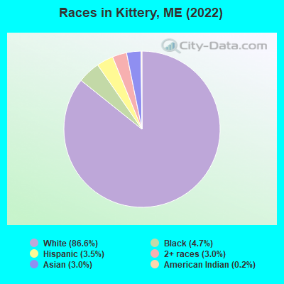
- 4,58386.6%White alone
- 2474.7%Black alone
- 1853.5%Hispanic
- 1583.0%Asian alone
- 1593.0%Two or more races
- 100.2%American Indian alone
Races in Kittery detailed stats: ancestries, foreign born residents, place of birth
According to our research of Maine and other state lists, there were 11 registered sex offenders living in Kittery, Maine as of April 27, 2024.
The ratio of all residents to sex offenders in Kittery is 428 to 1.
The ratio of registered sex offenders to all residents in this city is near the state average.
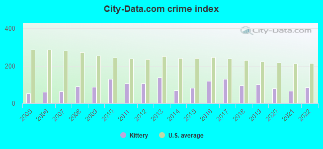
Type |
2009 |
2010 |
2011 |
2012 |
2013 |
2014 |
2015 |
2016 |
2017 |
2018 |
2019 |
2020 |
2021 |
2022 |
|---|---|---|---|---|---|---|---|---|---|---|---|---|---|---|
| Murders (per 100,000) | 0 (0.0) | 0 (0.0) | 0 (0.0) | 0 (0.0) | 0 (0.0) | 0 (0.0) | 0 (0.0) | 0 (0.0) | 0 (0.0) | 0 (0.0) | 0 (0.0) | 0 (0.0) | 0 (0.0) | 0 (0.0) |
| Rapes (per 100,000) | 2 (19.0) | 4 (42.1) | 1 (10.5) | 1 (10.5) | 6 (62.9) | 0 (0.0) | 1 (10.3) | 4 (41.3) | 5 (51.7) | 4 (41.0) | 7 (70.8) | 5 (50.7) | 2 (20.2) | 1 (9.7) |
| Robberies (per 100,000) | 0 (0.0) | 2 (21.1) | 1 (10.5) | 3 (31.4) | 3 (31.4) | 0 (0.0) | 2 (20.6) | 3 (31.0) | 4 (41.4) | 1 (10.3) | 0 (0.0) | 0 (0.0) | 2 (20.2) | 0 (0.0) |
| Assaults (per 100,000) | 1 (9.5) | 0 (0.0) | 2 (21.1) | 6 (62.8) | 2 (21.0) | 0 (0.0) | 7 (72.2) | 8 (82.6) | 4 (41.4) | 6 (61.5) | 1 (10.1) | 1 (10.1) | 2 (20.2) | 4 (38.9) |
| Burglaries (per 100,000) | 15 (142.5) | 35 (368.8) | 21 (221.3) | 15 (157.1) | 12 (125.8) | 6 (62.5) | 11 (113.5) | 6 (61.9) | 5 (51.7) | 10 (102.5) | 12 (121.3) | 4 (40.6) | 2 (20.2) | 6 (58.4) |
| Thefts (per 100,000) | 149 (1,416) | 144 (1,517) | 170 (1,792) | 157 (1,644) | 153 (1,604) | 138 (1,438) | 110 (1,135) | 128 (1,321) | 149 (1,541) | 95 (973.9) | 78 (788.7) | 79 (801.6) | 89 (897.6) | 159 (1,547) |
| Auto thefts (per 100,000) | 7 (66.5) | 4 (42.1) | 4 (42.2) | 0 (0.0) | 3 (31.4) | 8 (83.3) | 0 (0.0) | 5 (51.6) | 3 (31.0) | 2 (20.5) | 2 (20.2) | 3 (30.4) | 3 (30.3) | 6 (58.4) |
| Arson (per 100,000) | 1 (9.5) | 2 (21.1) | 0 (0.0) | 0 (0.0) | 1 (10.5) | 0 (0.0) | 1 (10.3) | 0 (0.0) | 0 (0.0) | 0 (0.0) | 1 (10.1) | 0 (0.0) | 0 (0.0) | 0 (0.0) |
| City-Data.com crime index | 89.0 | 129.9 | 106.3 | 107.1 | 139.4 | 68.5 | 82.3 | 120.2 | 129.8 | 96.0 | 100.3 | 80.0 | 66.0 | 86.2 |
The City-Data.com crime index weighs serious crimes and violent crimes more heavily. Higher means more crime, U.S. average is 246.1. It adjusts for the number of visitors and daily workers commuting into cities.
Crime rate in Kittery detailed stats: murders, rapes, robberies, assaults, burglaries, thefts, arson
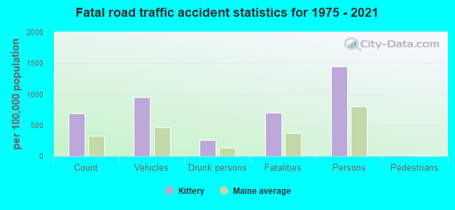
Full-time law enforcement employees in 2021, including police officers: 29 (23 officers - 22 male; 1 female).
| Officers per 1,000 residents here: | 2.32 |
| Maine average: | 1.71 |
 Recent articles from our blog. Our writers, many of them Ph.D. graduates or candidates, create easy-to-read articles on a wide variety of topics.

 | New England Fishmongers - Kittery (0 replies) |
| Looking for a short term lease small office space in the Kittery/Seacoast area (1 reply) |
| Small houses Part 2 (86 replies) |
| Suggestions on where to live? Working in Kittery. (8 replies) |
| Lighthouse tours in southern Maine? (7 replies) |
| Overwhelmed by the options in Maine (help?) (21 replies) |
Latest news from Kittery, ME collected exclusively by city-data.com from local newspapers, TV, and radio stations
Kittery, ME City Guides:
Ancestries: Irish (24.8%), English (8.3%), German (7.2%), French Canadian (5.9%), European (5.3%), American (4.2%).
Current Local Time: EST time zone
Incorporated on 11/20/1652
Elevation: 22 feet
Land area: 2.81 square miles.
Population density: 1,623 people per square mile (low).
331 residents are foreign born (2.3% Asia, 1.4% Europe, 1.0% Latin America, 1.0% Africa).
| This place: | 6.2% |
| Maine: | 3.8% |
Median real estate property taxes paid for housing units with mortgages in 2022: $4,127 (1.1%)
Median real estate property taxes paid for housing units with no mortgage in 2022: $5,376 (1.1%)
Nearest city with pop. 50,000+: Haverhill, MA  (27.7 miles , pop. 58,969).
Nearest city with pop. 200,000+: Boston, MA (56.0 miles , pop. 589,141).
Nearest city with pop. 1,000,000+: Bronx, NY (223.6 miles , pop. 1,332,650).
Nearest cities:
), ), ), Latitude: 43.09 N, Longitude: 70.74 W
Daytime population change due to commuting: +8,291 (+156.6%)
Workers who live and work in this place: 1,282 (50.6%)
Area code: 207
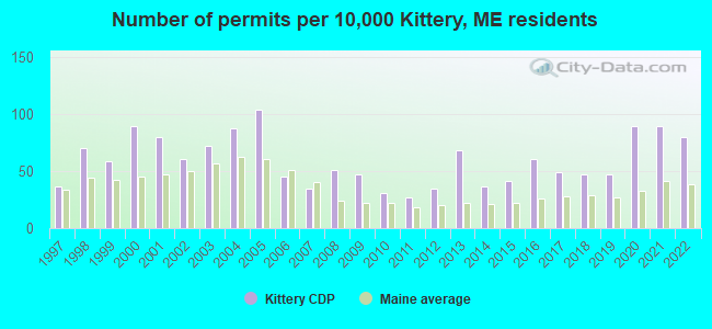
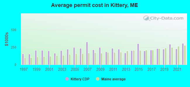
Single-family new house construction building permits:
- 2022: 39 buildings, average cost: $309,100
- 2021: 44 buildings, average cost: $228,300
- 2020: 44 buildings, average cost: $296,400
- 2019: 23 buildings, average cost: $226,100
- 2018: 23 buildings, average cost: $234,200
- 2017: 24 buildings, average cost: $210,900
- 2016: 30 buildings, average cost: $201,400
- 2015: 20 buildings, average cost: $303,300
- 2014: 18 buildings, average cost: $201,500
- 2013: 33 buildings, average cost: $171,600
- 2012: 17 buildings, average cost: $223,100
- 2011: 13 buildings, average cost: $235,000
- 2010: 15 buildings, average cost: $184,700
- 2009: 23 buildings, average cost: $250,200
- 2008: 25 buildings, average cost: $217,800
- 2007: 17 buildings, average cost: $327,900
- 2006: 22 buildings, average cost: $235,100
- 2005: 51 buildings, average cost: $248,100
- 2004: 43 buildings, average cost: $222,600
- 2003: 35 buildings, average cost: $204,000
- 2002: 30 buildings, average cost: $165,100
- 2001: 39 buildings, average cost: $199,100
- 2000: 44 buildings, average cost: $207,800
- 1999: 29 buildings, average cost: $206,900
- 1998: 34 buildings, average cost: $154,500
- 1997: 18 buildings, average cost: $157,800
| Here: | 3.1% |
| Maine: | 3.4% |
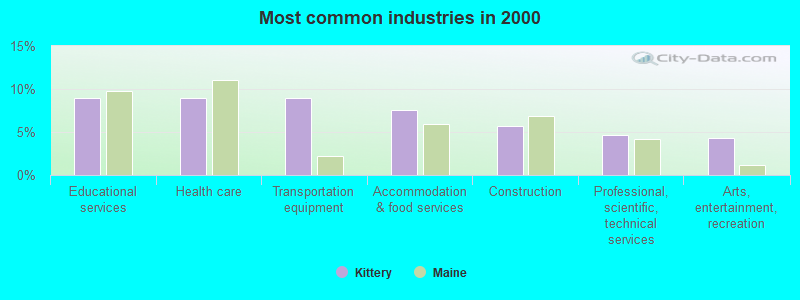
- Educational services (9.0%)
- Health care (8.9%)
- Transportation equipment (8.9%)
- Accommodation & food services (7.5%)
- Construction (5.7%)
- Professional, scientific, technical services (4.7%)
- Arts, entertainment, recreation (4.3%)

- Transportation equipment (12.3%)
- Construction (10.4%)
- Accommodation & food services (8.4%)
- Professional, scientific, technical services (7.4%)
- Educational services (6.8%)
- Arts, entertainment, recreation (6.0%)
- Motor vehicle & parts dealers (3.6%)
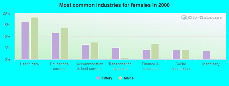
- Health care (16.3%)
- Educational services (11.4%)
- Accommodation & food services (6.5%)
- Transportation equipment (5.2%)
- Finance & insurance (4.3%)
- Social assistance (4.1%)
- Machinery (3.6%)
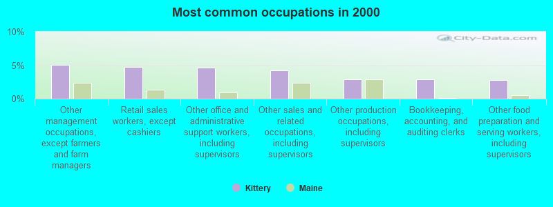
- Other management occupations, except farmers and farm managers (5.1%)
- Retail sales workers, except cashiers (4.8%)
- Other office and administrative support workers, including supervisors (4.6%)
- Other sales and related occupations, including supervisors (4.2%)
- Other production occupations, including supervisors (2.9%)
- Bookkeeping, accounting, and auditing clerks (2.9%)
- Other food preparation and serving workers, including supervisors (2.8%)
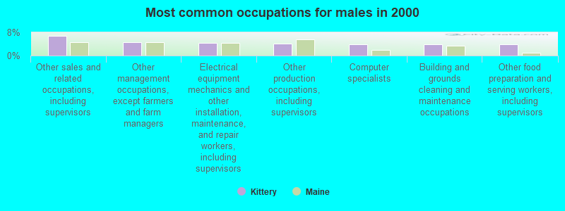
- Other sales and related occupations, including supervisors (6.8%)
- Other management occupations, except farmers and farm managers (4.5%)
- Electrical equipment mechanics and other installation, maintenance, and repair workers, including supervisors (4.4%)
- Other production occupations, including supervisors (4.2%)
- Computer specialists (4.0%)
- Building and grounds cleaning and maintenance occupations (4.0%)
- Other food preparation and serving workers, including supervisors (3.9%)

- Other office and administrative support workers, including supervisors (8.6%)
- Retail sales workers, except cashiers (6.3%)
- Other management occupations, except farmers and farm managers (5.7%)
- Bookkeeping, accounting, and auditing clerks (5.4%)
- Secretaries and administrative assistants (4.2%)
- Child care workers (3.9%)
- Preschool, kindergarten, elementary, and middle school teachers (3.7%)
Average climate in Kittery, Maine
Based on data reported by over 4,000 weather stations


|
|

(lower is better)
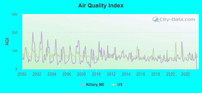
Air Quality Index (AQI) level in 2022 was 61.4. This is about average.
| City: | 61.4 |
| U.S.: | 72.6 |
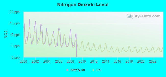
Nitrogen Dioxide (NO2) [ppb] level in 2008 was 7.38. This is significantly worse than average. Closest monitor was 0.6 miles away from the city center.
| City: | 7.38 |
| U.S.: | 5.11 |
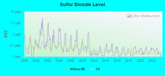
Sulfur Dioxide (SO2) [ppb] level in 2022 was 1.48. This is about average. Closest monitor was 0.3 miles away from the city center.
| City: | 1.48 |
| U.S.: | 1.51 |
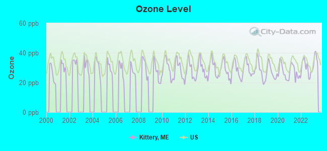
Ozone [ppb] level in 2022 was 29.7. This is about average. Closest monitor was 0.6 miles away from the city center.
| City: | 29.7 |
| U.S.: | 33.3 |
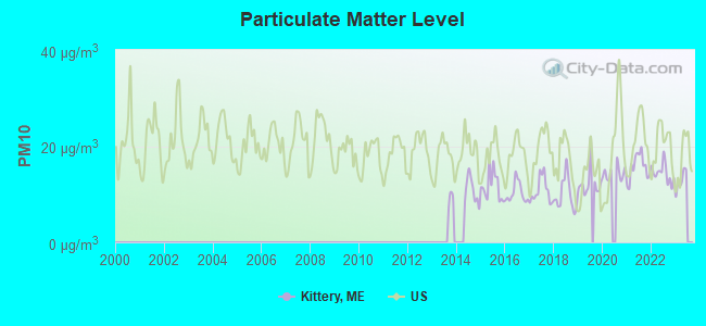
Particulate Matter (PM10) [µg/m3] level in 2022 was 14.4. This is better than average. Closest monitor was 1.1 miles away from the city center.
| City: | 14.4 |
| U.S.: | 19.2 |
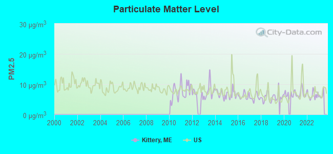
Particulate Matter (PM2.5) [µg/m3] level in 2022 was 6.41. This is better than average. Closest monitor was 1.1 miles away from the city center.
| City: | 6.41 |
| U.S.: | 8.11 |
Tornado activity:
Kittery-area historical tornado activity is significantly above Maine state average. It is 59% smaller than the overall U.S. average.
On 6/9/1953, a category F3 (max. wind speeds 158-206 mph) tornado 14.2 miles away from the Kittery place center injured 5 people and caused between $5000 and $50,000 in damages.
On 6/19/1957, a category F2 (max. wind speeds 113-157 mph) tornado 3.1 miles away from the place center injured one person and caused between $5000 and $50,000 in damages.
Earthquake activity:
Kittery-area historical earthquake activity is significantly above Maine state average. It is 73% smaller than the overall U.S. average.On 10/16/2012 at 23:12:25, a magnitude 4.7 (4.7 ML, Depth: 10.0 mi, Class: Light, Intensity: IV - V) earthquake occurred 35.4 miles away from Kittery center
On 4/20/2002 at 10:50:47, a magnitude 5.3 (5.3 ML, Depth: 3.0 mi, Class: Moderate, Intensity: VI - VII) earthquake occurred 177.4 miles away from the city center
On 1/19/1982 at 00:14:42, a magnitude 4.7 (4.5 MB, 4.7 MD, 4.5 LG) earthquake occurred 51.7 miles away from Kittery center
On 10/7/1983 at 10:18:46, a magnitude 5.3 (5.1 MB, 5.3 LG, 5.1 ML) earthquake occurred 190.2 miles away from Kittery center
On 4/20/2002 at 10:50:47, a magnitude 5.2 (5.2 MB, 4.2 MS, 5.2 MW, 5.0 MW) earthquake occurred 177.3 miles away from the city center
On 8/21/1996 at 07:54:14, a magnitude 3.8 (3.8 LG, 3.6 LG, Depth: 6.2 mi, Class: Light, Intensity: II - III) earthquake occurred 81.6 miles away from the city center
Magnitude types: regional Lg-wave magnitude (LG), body-wave magnitude (MB), duration magnitude (MD), local magnitude (ML), surface-wave magnitude (MS), moment magnitude (MW)
Natural disasters:
The number of natural disasters in York County (31) is a lot greater than the US average (15).Major Disasters (Presidential) Declared: 23
Emergencies Declared: 8
Causes of natural disasters: Floods: 21, Storms: 16, Winter Storms: 6, Snows: 5, Winds: 3, Heavy Rains: 2, Hurricanes: 2, Blizzard: 1, Ice Storm: 1, Mudslide: 1, Snowfall: 1, Snowstorm: 1, Tornado: 1, Tropical Storm: 1 (Note: some incidents may be assigned to more than one category).
Hospitals and medical centers in Kittery:
Other hospitals and medical centers near Kittery:
- MARK WENTWORTH HOME (Nursing Home, about 2 miles away; PORTSMOUTH, NH)
- EDGEWOOD CENTRE (THE) (Nursing Home, about 3 miles away; PORTSMOUTH, NH)
- CLIPPER HARBOR OF PORTSMOUTH CARE AND REHABILITATI (Nursing Home, about 3 miles away; PORTSMOUTH, NH)
- SEACOAST DIALYSIS CENTER (Dialysis Facility, about 4 miles away; PORTSMOUTH, NH)
- PORTSMOUTH REGIONAL HOSPITAL Acute Care Hospitals (about 4 miles away; PORTSMOUTH, NH)
- BEACON HOSPICE (Hospital, about 5 miles away; YORK, ME)
- YORK HOSPITAL HOME CARE (Home Health Center, about 6 miles away; YORK, ME)
Operable nuclear power plant near Kittery:
- 16 miles: Seabrook in Seabrook, NH.
Colleges/universities with over 2000 students nearest to Kittery:
- University of New Hampshire-Main Campus (about 11 miles; Durham, NH; Full-time enrollment: 15,243)
- Northern Essex Community College (about 26 miles; Haverhill, MA; FT enrollment: 4,737)
- University of New England (about 32 miles; Biddeford, ME; FT enrollment: 4,539)
- Merrimack College (about 36 miles; North Andover, MA; FT enrollment: 2,734)
- North Shore Community College (about 36 miles; Danvers, MA; FT enrollment: 5,195)
- Southern New Hampshire University (about 37 miles; Manchester, NH; FT enrollment: 16,552)
- Endicott College (about 38 miles; Beverly, MA; FT enrollment: 4,064)
Public high school in Kittery:
- ROBERT W TRAIP ACADEMY (Location: 12 WILLIAMS AVENUE, Grades: 9-12)
Public elementary/middle school in Kittery:
- SHAPLEIGH SCHOOL (Location: 43 STEVENSON ROAD, Grades: 4-8)
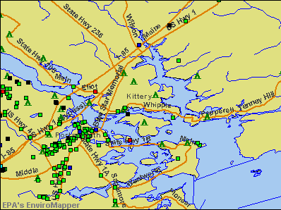
Points of interest:
Notable locations in Kittery: Pier Number 2 (A), Kittery Historical and Naval Museum (B), Kittery Fire Department Georges Road Station (C), John Paul Jones Memorial (D), Kittery Depot (E), Portsmouth Naval Shipyard Fire Department (F), Rice Public Library (G), Portsmouth Naval Shipyard Command Museum (H). Display/hide their locations on the map
Shopping Center: Maine Gate Factory Store Shopping Center (1). Display/hide its location on the map
Churches in Kittery include: Second Christian Congregational Church (A), Church of Christ (B). Display/hide their locations on the map
Cemeteries: Highland Cemetery (1), Orchard Grove Cemetery (2). Display/hide their locations on the map
Reservoir: Imhoff Tank (A). Display/hide its location on the map
Creek: Chickering Creek (A). Display/hide its location on the map
Tourist attraction: Maine Tourism Association (Interstate Highway).
Hotels: Super 8 Kittery (85 US Route 1 Bypass South), Northeaster Motel (USRoute 1 Bypass), Coachman Inn (380 US Route 1), Portsmouth Harbor Inn & Spa (6 Water Street), Days Inn (2 Gorges Rd), Litson Villas (127 State Road).
Birthplace of: Dennis C. Blair - Admiral, Sandi Jackson - Politician, Scott Brown - Senator, Arthur Shawcross - Criminal, John O'Hurley - Actor, Monique Edwards - Actor, William Whipple - Signatory of the Declaration of Independence, Hunt Slonem - Artist.
Drinking water stations with addresses in Kittery and their reported violations in the past:
KITTERY WATER DISTRICT (Population served: 13,148, Surface water):Past monitoring violations:WEATHERVANE RESTAURANT (Serves NH, Population served: 370, Groundwater):
- Monitoring and Reporting (DBP) - Between JUL-2010 and SEP-2010, Contaminant: TTHM. Follow-up actions: St Public Notif requested (APR-27-2011), St Formal NOV issued (APR-27-2011), St Public Notif received (JUL-11-2011), St Compliance achieved (DEC-08-2011)
Past monitoring violations:WEATHERVANE REST 4 (Serves NH, Population served: 100, Groundwater):
- One routine major monitoring violation
Past health violations:
- MCL, Acute (TCR) - Between OCT-2012 and DEC-2012, Contaminant: Coliform. Follow-up actions: St Public Notif requested (OCT-15-2012), St Violation/Reminder Notice (OCT-15-2012), St Public Notif received (OCT-19-2012), St Compliance achieved (MAY-15-2013)
| This place: | 2.1 people |
| Maine: | 2.3 people |
| This place: | 51.1% |
| Whole state: | 62.9% |
| This place: | 8.3% |
| Whole state: | 9.4% |
Likely homosexual households (counted as self-reported same-sex unmarried-partner households)
- Lesbian couples: 0.6% of all households
- Gay men: 0.6% of all households
People in group quarters in Kittery in 2010:
- 29 people in military barracks and dormitories (nondisciplinary)
- 27 people in military ships
- 6 people in workers' group living quarters and job corps centers
People in group quarters in Kittery in 2000:
- 136 people in military transient quarters for temporary residents
- 7 people in nursing homes
- 5 people in other group homes
Banks with branches in Kittery (2011 data):
- TD Bank, National Association: Kittery Branch at 30 State Road, branch established on 1973/09/10. Info updated 2010/10/04: Bank assets: $188,912.6 mil, Deposits: $153,149.8 mil, headquarters in Wilmington, DE, positive income, 1314 total offices, Holding Company: Toronto-Dominion Bank, The
- People's United Bank: Kittery Branch at 17 Walker Street, branch established on 1980/05/01. Info updated 2012/02/16: Bank assets: $27,319.3 mil, Deposits: $20,835.4 mil, headquarters in Bridgeport, CT, positive income, Commercial Lending Specialization, 374 total offices
- KeyBank National Association: Kittery Branch at 12 Shapleigh Road, branch established on 1963/04/01. Info updated 2008/03/03: Bank assets: $86,198.8 mil, Deposits: $64,214.8 mil, headquarters in Cleveland, OH, positive income, Commercial Lending Specialization, 1067 total offices, Holding Company: Keycorp
- Kennebunk Savings Bank: Kittery Branch at 4 Shapleigh Road, branch established on 2002/04/24. Info updated 2010/05/27: Bank assets: $821.4 mil, Deposits: $660.6 mil, headquarters in Kennebunk, ME, positive income, Commercial Lending Specialization, 15 total offices
For population 15 years and over in Kittery:
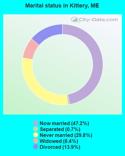
- Never married: 29.8%
- Now married: 47.2%
- Separated: 0.7%
- Widowed: 8.4%
- Divorced: 13.9%
For population 25 years and over in Kittery:
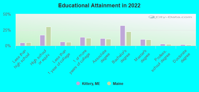
- High school or higher: 95.5%
- Bachelor's degree or higher: 42.4%
- Graduate or professional degree: 13.8%
- Unemployed: 3.8%
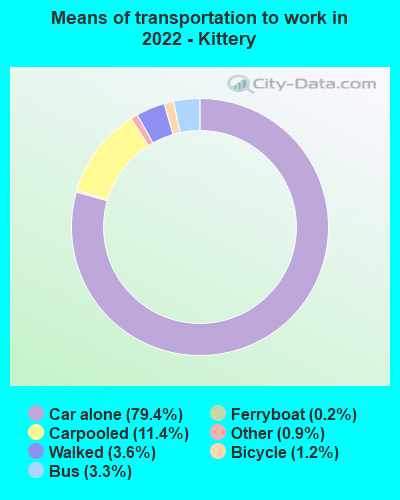
- Mean travel time to work (commute): 14.0 minutes
| Here: | 8.8 |
| Maine average: | 10.3 |


Graphs represent county-level data. Detailed 2008 Election Results
Religion statistics for Kittery, ME (based on York County data)


| Religion | Adherents | Congregations |
|---|---|---|
| Catholic | 40,283 | 16 |
| Mainline Protestant | 11,480 | 64 |
| Evangelical Protestant | 6,086 | 51 |
| Other | 1,847 | 18 |
| Orthodox | 625 | 3 |
| Black Protestant | 119 | 1 |
| None | 136,691 | - |
Food Environment Statistics:
| This county: | 2.24 / 10,000 pop. |
| Maine: | 2.80 / 10,000 pop. |
| York County: | 0.05 / 10,000 pop. |
| Maine: | 0.14 / 10,000 pop. |
| York County: | 2.09 / 10,000 pop. |
| Maine: | 2.20 / 10,000 pop. |
| York County: | 4.23 / 10,000 pop. |
| State: | 5.75 / 10,000 pop. |
| York County: | 12.53 / 10,000 pop. |
| Maine: | 11.02 / 10,000 pop. |
| Here: | 7.7% |
| State: | 8.2% |
| This county: | 24.0% |
| State: | 25.0% |
Health and Nutrition:
| Here: | 51.6% |
| Maine: | 53.9% |
| This city: | 51.1% |
| State: | 52.9% |
| Kittery: | 28.5 |
| State: | 28.3 |
| Kittery: | 19.8% |
| Maine: | 19.9% |
| Here: | 8.5% |
| Maine: | 8.7% |
| Kittery: | 6.9 |
| Maine: | 6.9 |
| This city: | 33.4% |
| Maine: | 34.3% |
| Kittery: | 60.0% |
| State: | 60.5% |
| Kittery: | 80.5% |
| Maine: | 79.6% |
More about Health and Nutrition of Kittery, ME Residents
| Businesses in Kittery, ME | ||||
| Name | Count | Name | Count | |
|---|---|---|---|---|
| 7-Eleven | 1 | FedEx | 4 | |
| ALDO | 1 | Gap | 1 | |
| AT&T | 1 | Gymboree | 1 | |
| Ace Hardware | 1 | IZOD | 1 | |
| Aeropostale | 1 | J. Jill | 1 | |
| American Eagle Outfitters | 1 | J.Crew | 1 | |
| Ann Taylor | 1 | Jones New York | 2 | |
| Banana Republic | 1 | Levi Strauss & Co. | 1 | |
| Brooks Brothers | 1 | McDonald's | 1 | |
| Brookstone | 1 | Motherhood Maternity | 1 | |
| Burger King | 1 | Old Navy | 1 | |
| Charlotte Russe | 1 | Pac Sun | 1 | |
| Chico's | 1 | Ramada | 1 | |
| Circle K | 3 | Rite Aid | 1 | |
| Coldwater Creek | 1 | Rue21 | 1 | |
| Crate & Barrel | 1 | Skechers USA | 1 | |
| Dairy Queen | 1 | Starbucks | 1 | |
| Days Inn | 1 | Subway | 1 | |
| Domino's Pizza | 1 | True Value | 1 | |
| DressBarn | 2 | U-Haul | 2 | |
| Dressbarn | 2 | UPS | 1 | |
| Dunkin Donuts | 1 | Vans | 1 | |
| Eddie Bauer | 1 | |||
Strongest AM radio stations in Kittery:
- WMYF (1380 AM; 1 kW; PORTSMOUTH, NH; Owner: CAPSTAR TX LIMITED PARTNERSHIP)
- WTSN (1270 AM; 5 kW; DOVER, NH; Owner: GARRISON CITY BROADCASTING, INC.)
- WGIN (930 AM; 10 kW; ROCHESTER, NH; Owner: CAPSTAR TX LIMITED PARTNERSHIP)
- WRKO (680 AM; 50 kW; BOSTON, MA; Owner: ENTERCOM BOSTON LICENSE, LLC)
- WGIP (1540 AM; 5 kW; EXETER, NH; Owner: CAPSTAR TX LIMITED PARTNERSHIP)
- WBZ (1030 AM; 50 kW; BOSTON, MA; Owner: INFINITY BROADCASTING OPERATIONS, INC.)
- WEEI (850 AM; 50 kW; BOSTON, MA; Owner: ENTERCOM BOSTON LICENSE, LLC)
- WWZN (1510 AM; 50 kW; BOSTON, MA; Owner: ROSE CITY RADIO CORPORATION)
- WKOX (1200 AM; 50 kW; FRAMINGHAM, MA; Owner: CAPSTAR TX LIMITED PARTNERSHIP)
- WBIX (1060 AM; 40 kW; NATICK, MA; Owner: LANGER BROADCASTING CORPORATION)
- WCRN (830 AM; 50 kW; WORCESTER, MA; Owner: CARTER BROADCASTING CORPORATION)
- WDER (1320 AM; 10 kW; DERRY, NH; Owner: BLOUNT COMMUNICATIONS, INC. OF NH)
- WMTW (870 AM; 10 kW; GORHAM, ME; Owner: RADIO PARTNERS OF MAINE, L.P.)
Strongest FM radio stations in Kittery:
- WHEB (100.3 FM; PORTSMOUTH, NH; Owner: CAPSTAR TX LIMITED PARTNERSHIP)
- WUBB (95.3 FM; YORK CENTER, ME; Owner: CAPSTAR TX LIMITED PARTNERSHIP)
- WSHK (105.3 FM; KITTERY, ME; Owner: CITADEL BROADCASTING COMPANY)
- WERZ (107.1 FM; EXETER, NH; Owner: CAPSTAR TX LIMITED PARTNERSHIP)
- WOKQ (97.5 FM; DOVER, NH; Owner: CITADEL BROADCASTING COMPANY)
- WBYY (98.7 FM; SOMERSWORTH, NH; Owner: GARRISON CITY BROADCASTING, INC.)
- WUNH (91.3 FM; DURHAM, NH; Owner: UNIVERSITY OF NEW HAMPSHIRE)
- WPKQ (103.7 FM; NORTH CONWAY, NH; Owner: CITADEL BROADCASTING COMPANY)
- WSCY (106.9 FM; MOULTONBOROUGH, NH; Owner: NORTHEAST COMMUNICATIONS CORPORATION)
- WHOM (94.9 FM; MT. WASHINGTON, NH; Owner: CITADEL BROADCASTING COMPANY)
- WPHX-FM (92.1 FM; SANFORD, ME; Owner: FNX BROADCASTING LLC)
- WSEW (88.5 FM; SANFORD, ME; Owner: WORD RADIO EDUCATIONAL FOUNDATION)
- WMEA (90.1 FM; PORTLAND, ME; Owner: MAINE PUBLIC BROADCASTING CORPORATION)
- WXRV (92.5 FM; HAVERHILL, MA; Owner: BEANPOT BROADCASTING CORP.)
- WMEX (106.5 FM; FARMINGTON, NH; Owner: WIMMEX, LLC)
- WSAK (102.1 FM; HAMPTON, NH; Owner: CITADEL BROADCASTING COMPANY)
- WQSO (96.7 FM; ROCHESTER, NH; Owner: CAPSTAR TX LIMITED PARTNERSHIP)
- WNEF (91.7 FM; NEWBURYPORT, MA; Owner: UNIVERSITY OF MASSACHUSETTS)
- WGIR-FM (101.1 FM; MANCHESTER, NH; Owner: CAPSTAR TX LIMITED PARTNERSHIP)
- WLKZ (104.9 FM; WOLFEBORO, NH; Owner: TELE-MEDIA COMPANY OF NEW HAMPSHIRE, L.L.C.)
TV broadcast stations around Kittery:
- WHDN-LP (Channel 26; BOSTON, MA; Owner: GUENTER MARKSTEINER)
- WMEA-TV (Channel 26; BIDDEFORD, ME; Owner: MAINE PUBLIC BROADCASTING CORP.)
- WMTW-TV (Channel 8; POLAND SPRING, ME; Owner: WMTW BROADCAST GROUP, LLC)
- WFXZ-CA (Channel 24; BOSTON, MA; Owner: BOSTON BROADCASTING CORP.)
- WENH-TV (Channel 11; DURHAM, NH; Owner: UNIVERSITY OF NEW HAMPSHIRE)
Medal of Honor Recipients
Medal of Honor Recipient born in Kittery: Richard E. Seward.
- National Bridge Inventory (NBI) Statistics
- 20Number of bridges
- 367ft / 112mTotal length
- 301,153Total average daily traffic
- 21,070Total average daily truck traffic
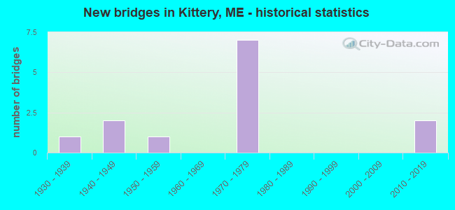
- New bridges - historical statistics
- 11930-1939
- 21940-1949
- 11950-1959
- 71970-1979
- 22010-2019
FCC Registered Cell Phone Towers:
1 (See the full list of FCC Registered Cell Phone Towers in Kittery)FCC Registered Antenna Towers:
15 (See the full list of FCC Registered Antenna Towers)FCC Registered Broadcast Land Mobile Towers:
18 (See the full list of FCC Registered Broadcast Land Mobile Towers in Kittery, ME)FCC Registered Microwave Towers:
3 (See the full list of FCC Registered Microwave Towers in this town)FCC Registered Maritime Coast & Aviation Ground Towers:
5 (See the full list of FCC Registered Maritime Coast & Aviation Ground Towers)FCC Registered Amateur Radio Licenses:
60 (See the full list of FCC Registered Amateur Radio Licenses in Kittery)FAA Registered Aircraft:
4- Aircraft: CESSNA 172I (Category: Land, Seats: 4, Weight: Up to 12,499 Pounds, Speed: 105 mph), Engine: LYCOMING 0-320 SERIES (180 HP) (Reciprocating)
N-Number: 46291, N46291, N-46291, Serial Number: 17257160, Year manufactured: 1968, Airworthiness Date: 07/19/1968, Certificate Issue Date: 10/26/2001
Registrant (Individual): Igor I Iii Sikorsky, 20 Trafton Ln, Kittery, ME 03904 - Aircraft: PIPER J3C-65 (Category: Land, Seats: 2, Weight: Up to 12,499 Pounds, Speed: 67 mph), Engine: CONT MOTOR A&C65 SERIES (65 HP) (Reciprocating)
N-Number: 7486H, N7486H, N-7486H, Serial Number: 20754, Year manufactured: 1946, Airworthiness Date: 11/06/1955, Certificate Issue Date: 07/22/2020
Registrant (Individual): Tyler H Jackson, 30 Old Dennett Rd, Kittery, ME 03904 - Aircraft: FREEDMAN PITTS SPECIAL (Category: Land, Weight: Up to 12,499 Pounds, Speed: 108 mph), Engine: LYCOMING 0-290 SERIES (140 HP) (Reciprocating)
N-Number: 2263, N2263, N-2263, Serial Number: 5729-1, Year manufactured: 1971, Airworthiness Date: 07/25/1975, Certificate Issue Date: 09/19/2012
Registrant (Co-Owned): Charles H Jr Denault, 11 Melanies Ct, Kittery, ME 03904, Other Owners: Charles H Iii Denault - Aircraft: MOULTON HOWARD WELLS ULTRA-PUP BY PRECPTR (Category: Land, Seats: 2, Weight: Up to 12,499 Pounds), Engine: Reciprocating
N-Number: 3073X, N3073X, N-3073X, Serial Number: 01, Certificate Issue Date: 07/01/2002
Registrant (Individual): Howard Wells Moulton, 282 Haley Rd, Kittery, ME 03904
Deregistered: Cancel Date: 07/09/1979, Exported to: Switzerland
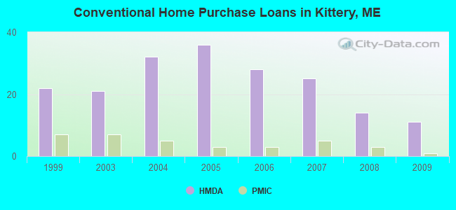
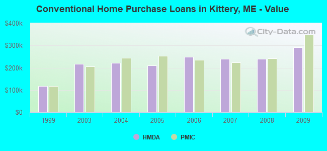
| Home Mortgage Disclosure Act Aggregated Statistics For Year 2009 (Based on 2 partial tracts) | ||||||||||
| A) FHA, FSA/RHS & VA Home Purchase Loans | B) Conventional Home Purchase Loans | C) Refinancings | D) Home Improvement Loans | F) Non-occupant Loans on < 5 Family Dwellings (A B C & D) | ||||||
|---|---|---|---|---|---|---|---|---|---|---|
| Number | Average Value | Number | Average Value | Number | Average Value | Number | Average Value | Number | Average Value | |
| LOANS ORIGINATED | 5 | $243,336 | 11 | $292,176 | 55 | $237,040 | 7 | $104,609 | 9 | $323,943 |
| APPLICATIONS APPROVED, NOT ACCEPTED | 0 | $0 | 1 | $172,130 | 3 | $248,060 | 1 | $143,390 | 1 | $184,080 |
| APPLICATIONS DENIED | 1 | $101,240 | 4 | $174,120 | 14 | $299,887 | 3 | $98,433 | 2 | $406,250 |
| APPLICATIONS WITHDRAWN | 1 | $256,510 | 2 | $186,780 | 10 | $250,562 | 0 | $0 | 1 | $280,790 |
| FILES CLOSED FOR INCOMPLETENESS | 0 | $0 | 0 | $0 | 2 | $248,175 | 0 | $0 | 0 | $0 |
Detailed HMDA statistics for the following Tracts: 0380.01 , 0380.02
| Private Mortgage Insurance Companies Aggregated Statistics For Year 2009 (Based on 2 partial tracts) | ||||
| A) Conventional Home Purchase Loans | B) Refinancings | |||
|---|---|---|---|---|
| Number | Average Value | Number | Average Value | |
| LOANS ORIGINATED | 1 | $347,100 | 1 | $373,290 |
| APPLICATIONS APPROVED, NOT ACCEPTED | 1 | $192,740 | 0 | $0 |
| APPLICATIONS DENIED | 0 | $0 | 0 | $0 |
| APPLICATIONS WITHDRAWN | 0 | $0 | 0 | $0 |
| FILES CLOSED FOR INCOMPLETENESS | 0 | $0 | 0 | $0 |
Detailed PMIC statistics for the following Tracts: 0380.01 , 0380.02
2004 - 2018 National Fire Incident Reporting System (NFIRS) incidents
- Fire incident types reported to NFIRS in Kittery, ME
- 22449.8%Structure Fires
- 11325.1%Outside Fires
- 6815.1%Mobile Property/Vehicle Fires
- 4510.0%Other
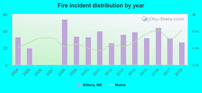 Based on the data from the years 2004 - 2018 the average number of fires per year is 30. The highest number of reported fire incidents - 54 took place in 2008, and the least - 0 in 2006. The data has a declining trend.
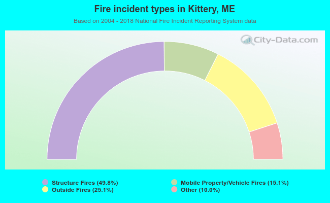 When looking into fire subcategories, the most incidents belonged to: Structure Fires (49.8%), and Outside Fires (25.1%).
Fire-safe hotels and motels in Kittery, Maine:
- Ramada Kittery, 2 Gorges Rd Rt 1 Byp, Kittery, Maine 03904 , Phone: (207) 439-5555, Fax: (207) 439-6777
- Kittery Inn and Suites, 70 US Rt 1 Byp, Kittery, Maine 03904 , Phone: (207) 439-9324, Fax: (888) 439-4657
- Hampton Inn & Suites Kittery, 275 US Rt 1, Kittery, Maine 03904 , Phone: (207) 439-0751
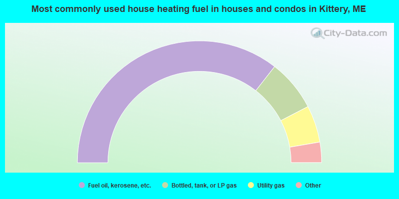
- 71.1%Fuel oil, kerosene, etc.
- 13.7%Bottled, tank, or LP gas
- 9.8%Utility gas
- 3.1%Wood
- 2.2%Electricity
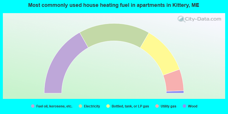
- 33.6%Fuel oil, kerosene, etc.
- 33.0%Electricity
- 22.2%Bottled, tank, or LP gas
- 10.0%Utility gas
- 1.1%Wood
Kittery compared to Maine state average:
- Unemployed percentage significantly below state average.
- Black race population percentage significantly above state average.
- Hispanic race population percentage above state average.
- Median age below state average.
- Foreign-born population percentage above state average.
- Renting percentage above state average.
- Length of stay since moving in significantly above state average.
- Percentage of population with a bachelor's degree or higher above state average.
Kittery on our top lists:
- #16 on the list of "Top 101 cities with the largest percentage of people in military transient quarters for temporary residents (population 1,000+)"
- #86 on the list of "Top 101 cities with the most residents born in Nigeria (population 500+)"
- #96 on the list of "Top 101 cities with the most residents born in Other Australian and New Zealand Subregion (population 500+)"
- #21 on the list of "Top 101 counties with the highest percentage of residents that smoked 100+ cigarettes in their lives"
- #35 on the list of "Top 101 counties with the lowest number of births per 1000 residents 2007-2013"
- #70 on the list of "Top 101 counties with the highest percentage of residents that keep firearms around their homes"
- #77 on the list of "Top 101 counties with the best general health status score of residents (1-5), 3 years of data"

|
|
Total of 26 patent applications in 2008-2024.