Bridge Statistics for La Quinta, California (CA)
Condition, Traffic, Stress, Structural Evaluation, Project Costs
- National Bridge Inventory (NBI) Statistics
- 11Number of bridges
- 295ft / 90mTotal length
- $24,173,000Total costs
- 186,949Total average daily traffic
- 2,658Total average daily truck traffic
- 169,370Total future (year 2033) average daily traffic
- National Bridge Inventory (NBI) Registered Bridges for La Quinta
- No street view available for this location
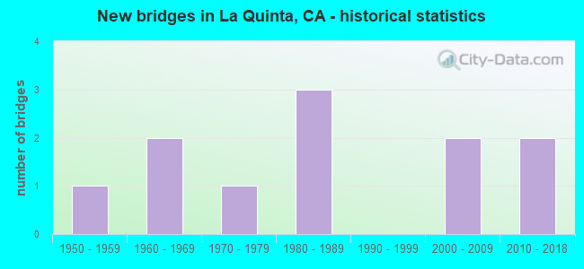
- New bridges - historical statistics
- 11950-1959
- 21960-1969
- 11970-1979
- 31980-1989
- 22000-2009
- 22010-2018
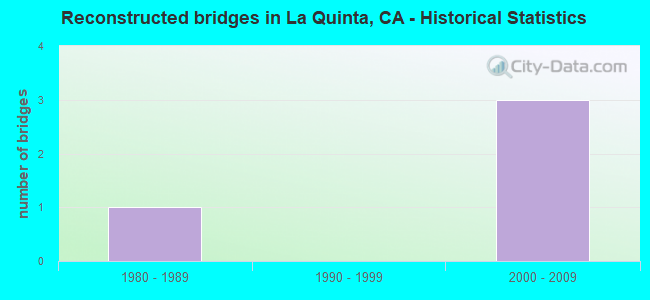
- Reconstructed bridges - Historical Statistics
- 11980-1989
- 01990-1999
- 32000-2009
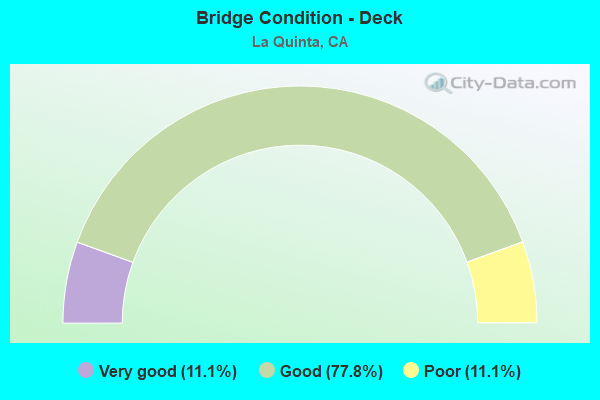
- Bridge Condition - Deck
- 11.1%Very good
- 77.8%Good
- 11.1%Poor
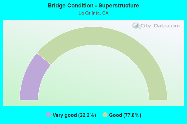
- Bridge Condition - Superstructure
- 22.2%Very good
- 77.8%Good
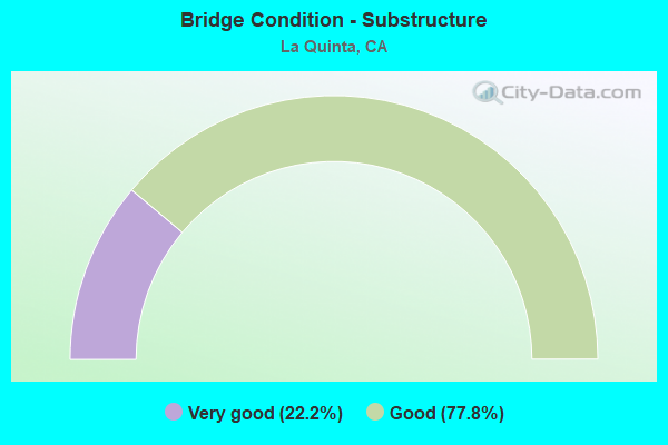
- Bridge Condition - Substructure
- 22.2%Very good
- 77.8%Good
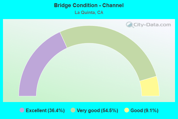
- Bridge Condition - Channel
- 36.4%Excellent
- 54.5%Very good
- 9.1%Good
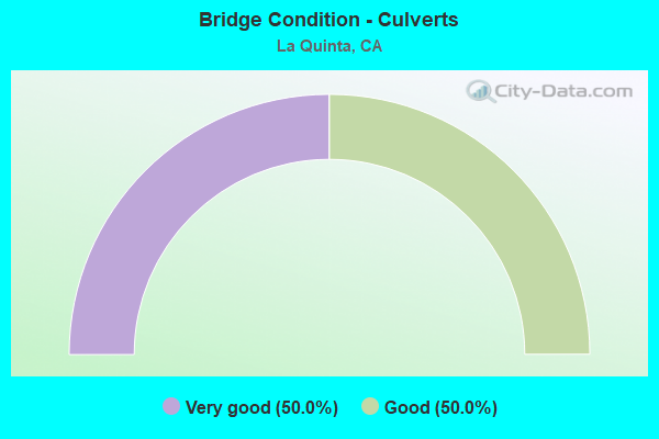
- Bridge Condition - Culverts
- 50.0%Very good
- 50.0%Good
Find on map >> Show street view
Structure Number: 56C0071, Location: 1.47 MI. W/O RTE 91 FWY. (Lat: 33.990958, Lng: -117.394969), Route carried "on" structure: City street , Year Built: 1958, Status: Open, Structure Length: 33.65m (110.40ft), Average Daily Traffic: 23,060 (year 2011), Truck Traffic: 4%, Average Future Daily Traffic: 28,667 (year 2036), Design Load: HS 20, Features Intersected: SANTA ANA RIVER, Facility Carried by Structure: MSSN BL/BUENA VST
Minimum Vertical Clearance: 30+ m (98+ ft), Kilometerpoint: 0.000, Lanes on structure: 4, Owner: City or Municipal Highway Agency, Approaching Roadway Width: 195.0m (639.8ft), Skew: 2 degrees, Material/Design: Prestressed concrete, Design/Construction: Stringer/Multi-beam, Number Of Spans In Main Unit: 11, Length of Maximum Span: 30.5m (100.1ft), Curb or Sidewalk Widths: Left: 1.5m (4.9ft), Right: 0.6m (2.0ft), Curb-To-Curb Width: 15.8m (51.8ft), Out-to-Out Width: 18.6m (61.0ft)
Condition: Deck: Poor, Superstructure: Good, Substructure: Good, Channel: Very good, Operating Rating: 49.2 metric tons, Method Used To Determine Operating Rating: Load and Resistance Factor Rating (LRFR) rating reported by rating factor(RF) method using HL-93 loadings, Inventory Rating: 20.7 metric tons, Method Used To Determine Inventory Rating: Load and Resistance Factor Rating (LRFR) rating reported by rating factor(RF) method using HL-93 loadings, Structural Evaluation: Somewhat better than minimum adequacy, Deck Geometry: Meets minimum limits, Waterway Adequacy: Superior to present desirable criteria, Approach Roadway Alignment: Equal to present desirable criteria, Length Of Structure Improvement: 336.50m (1104.00ft), Designated Inspection Frequency: Every 24 months, Inspection Date: January 2018, Bridge Improvement Cost: $14,388,000, Roadway Improvement Cost: $2,877,000, Total Project Cost: $24,173,000 ( Estimate for 2018), Deck Structure Type: Concrete Cast-file-Place
Find on map >> Show street view
Structure Number: 56C0076, Location: 0.35 MI. E/O JEFFERSON ST (Lat: 33.670842, Lng: -116.263089), Route carried "on" structure: City street , Year Built: 1966, Year Reconstructed: 2009, Status: Open, Structure Length: 1.92m (6.30ft), Average Daily Traffic: 9,508 (year 2017), Truck Traffic: 1%, Average Future Daily Traffic: 4,163 (year 2037), Design Load: HS 20, Features Intersected: COACHELLA CANAL, Facility Carried by Structure: 52ND AVENUE
Minimum Vertical Clearance: 30+ m (98+ ft), Kilometerpoint: 0.000, Lanes on structure: 4, Base Highway Network: Yes, Owner: City or Municipal Highway Agency, Approaching Roadway Width: 206.0m (675.9ft), Skew: 4 degrees, Material/Design: Prestressed concrete, Design/Construction: Stringer/Multi-beam, Number Of Spans In Main Unit: 1, Length of Maximum Span: 18.9m (62.0ft), Curb or Sidewalk Widths: Left: 1.4m (4.6ft), Right: 1.4m (4.6ft), Curb-To-Curb Width: 20.6m (67.6ft), Out-to-Out Width: 29.9m (98.1ft)
Condition: Deck: Very good, Superstructure: Very good, Substructure: Very good, Channel: Excellent, Operating Rating: 54.1 metric tons, Method Used To Determine Operating Rating: Assigned rating based on Load Factor Design (LFD) reported in metric tons, Inventory Rating: 32.4 metric tons, Method Used To Determine Inventory Rating: Assigned rating based on Load Factor Design (LFD) reported in metric tons, Structural Evaluation: Equal to present desirable criteria, Deck Geometry: Superior to present desirable criteria, Waterway Adequacy: Equal to present desirable criteria, Approach Roadway Alignment: Equal to present desirable criteria, Designated Inspection Frequency: Every 48 months, Inspection Date: October 2015, Deck Structure Type: Concrete Cast-file-Place, Wearing Surface/Protective System: Wearing Surface: Bituminous
Find on map >> Show street view
Structure Number: 56C026, Location: 0.5 MI W/O DEFRAIN BLVD. (Lat: 33.529911, Lng: -114.630142), Route carried "on" structure: County highway , Year Built: 1964, Status: Open, Structure Length: 0.79m (2.59ft), Average Daily Traffic: 300 (year 2002), Truck Traffic: 1%, Average Future Daily Traffic: 361 (year 2038), Design Load: HS 20, Features Intersected: "C" CANAL (SIPHON 87), Facility Carried by Structure: 24TH AVENUE
Minimum Vertical Clearance: 30+ m (98+ ft), Kilometerpoint: 0.000, Lanes on structure: 2, Owner: County Highway Agency, Approaching Roadway Width: 67.0m (219.8ft), Material/Design: Concrete, Design/Construction: Culvert, Number Of Spans In Main Unit: 3, Length of Maximum Span: 2.4m (7.9ft), Curb-To-Curb Width: 12.2m (40.0ft), Out-to-Out Width: 12.8m (42.0ft)
Condition: Channel: Very good, Culverts: Good, Operating Rating: 54.1 metric tons, Method Used To Determine Operating Rating: Field evaluation and documented engineering judgment, Inventory Rating: 32.4 metric tons, Method Used To Determine Inventory Rating: Field evaluation and documented engineering judgment, Structural Evaluation: Better than present minimum criteria, Deck Geometry: Superior to present desirable criteria, Waterway Adequacy: Superior to present desirable criteria, Approach Roadway Alignment: Equal to present desirable criteria, Designated Inspection Frequency: Every 48 months, Inspection Date: December 2016
Find on map >> Show street view
Structure Number: 56C0266, Location: 0.2 MI. N/O ST RTE 111 (Lat: 33.717061, Lng: -116.294747), Route carried "on" structure: City street , Year Built: 1976, Year Reconstructed: 1994, Status: Open, Structure Length: 15.71m (51.54ft), Average Daily Traffic: 37,370 (year 2017), Truck Traffic: 1%, Average Future Daily Traffic: 20,954 (year 2037), Design Load: HS 20, Features Intersected: WHITEWATER RIVER, Facility Carried by Structure: WASHINGTON STREET
Minimum Vertical Clearance: 30+ m (98+ ft), Kilometerpoint: 0.000, Lanes on structure: 6, Owner: City or Municipal Highway Agency, Approaching Roadway Width: 268.0m (879.3ft), Skew: 2 degrees, Material/Design: Concrete continuous, Design/Construction: Stringer/Multi-beam, Number Of Spans In Main Unit: 6, Length of Maximum Span: 28.2m (92.5ft), Curb or Sidewalk Widths: Left: 1.5m (4.9ft), Right: 1.5m (4.9ft), Curb-To-Curb Width: 26.8m (87.9ft), Out-to-Out Width: 30.6m (100.4ft)
Condition: Deck: Good, Superstructure: Very good, Substructure: Good, Channel: Very good, Operating Rating: 54.1 metric tons, Method Used To Determine Operating Rating: Assigned rating based on Load Factor Design (LFD) reported in metric tons, Inventory Rating: 32.4 metric tons, Method Used To Determine Inventory Rating: Assigned rating based on Load Factor Design (LFD) reported in metric tons, Structural Evaluation: Better than present minimum criteria, Deck Geometry: Better than present minimum criteria, Waterway Adequacy: Equal to present desirable criteria, Approach Roadway Alignment: Equal to present desirable criteria, Designated Inspection Frequency: Every 48 months, Inspection Date: November 2015, Deck Structure Type: Concrete Cast-file-Place
Find on map >> Show street view
Structure Number: 56C037, Location: 0.2 MI. E/O ELSWORTH AVE. (Lat: 33.918283, Lng: -117.266539), Route carried "on" structure: City street , Year Built: 1986, Status: Open, Structure Length: 0.07m (0.23ft), Average Daily Traffic: 500 (year 2006), Truck Traffic: 1%, Average Future Daily Traffic: 1,035 (year 2035), Design Load: HS 20, Features Intersected: FREDERICK STREET CHANNEL, Facility Carried by Structure: ADRIENNE AVENUE
Minimum Vertical Clearance: 30+ m (98+ ft), Kilometerpoint: 0.000, Lanes on structure: 2, Owner: City or Municipal Highway Agency, Approaching Roadway Width: 133.0m (436.4ft), Material/Design: Concrete, Design/Construction: Slab, Number Of Spans In Main Unit: 1, Length of Maximum Span: 6.4m (21.0ft), Curb or Sidewalk Widths: Left: 1.5m (4.9ft), Right: 1.5m (4.9ft), Curb-To-Curb Width: 13.3m (43.6ft), Out-to-Out Width: 17.1m (56.1ft)
Condition: Deck: Good, Superstructure: Good, Substructure: Good, Channel: Excellent, Operating Rating: 54.1 metric tons, Method Used To Determine Operating Rating: Assigned rating based on Load Factor Design (LFD) reported in metric tons, Inventory Rating: 32.4 metric tons, Method Used To Determine Inventory Rating: Assigned rating based on Load Factor Design (LFD) reported in metric tons, Structural Evaluation: Better than present minimum criteria, Deck Geometry: Superior to present desirable criteria, Waterway Adequacy: Equal to present desirable criteria, Approach Roadway Alignment: Equal to present desirable criteria, Designated Inspection Frequency: Every 48 months, Inspection Date: September 2017, Deck Structure Type: Concrete Cast-file-Place, Wearing Surface/Protective System: Wearing Surface: Bituminous
Find on map >> Show street view
Structure Number: 56C0377, Location: 0.2 MI S/O 50TH AVENUE (Lat: 33.682486, Lng: -116.294683), Route carried "on" structure: City street , Year Built: 1981, Year Reconstructed: 2000, Status: Open, Structure Length: 3.81m (12.50ft), Average Daily Traffic: 23,143 (year 2017), Truck Traffic: 1%, Average Future Daily Traffic: 20,677 (year 2035), Design Load: HS 20, Features Intersected: LA QUINTA CHANNEL, Facility Carried by Structure: WASHINGTON STREET
Minimum Vertical Clearance: 30+ m (98+ ft), Kilometerpoint: 0.000, Lanes on structure: 6, Owner: City or Municipal Highway Agency, Approaching Roadway Width: 239.0m (784.1ft), Skew: 23 degrees, Material/Design: Concrete continuous, Design/Construction: Slab, Number Of Spans In Main Unit: 4, Length of Maximum Span: 10.4m (34.1ft), Curb or Sidewalk Widths: Left: 1.5m (4.9ft), Right: 1.5m (4.9ft), Curb-To-Curb Width: 23.9m (78.4ft), Out-to-Out Width: 29.3m (96.1ft)
Condition: Deck: Good, Superstructure: Good, Substructure: Good, Channel: Excellent, Operating Rating: 54.1 metric tons, Method Used To Determine Operating Rating: Assigned rating based on Load Factor Design (LFD) reported in metric tons, Inventory Rating: 32.4 metric tons, Method Used To Determine Inventory Rating: Assigned rating based on Load Factor Design (LFD) reported in metric tons, Structural Evaluation: Better than present minimum criteria, Deck Geometry: Somewhat better than minimum adequacy, Waterway Adequacy: Equal to present desirable criteria, Approach Roadway Alignment: Equal to present desirable criteria, Designated Inspection Frequency: Every 48 months, Inspection Date: October 2017, Deck Structure Type: Concrete Cast-file-Place, Wearing Surface/Protective System: Wearing Surface: Bituminous
Find on map >> Show street view
Structure Number: 56C0378, Location: 0.3 MI. S/O 50TH AVENUE (Lat: 33.681431, Lng: -116.307875), Route carried "on" structure: City street , Year Built: 1981, Year Reconstructed: 2005, Status: Open, Structure Length: 2.26m (7.41ft), Average Daily Traffic: 12,462 (year 2017), Truck Traffic: 1%, Average Future Daily Traffic: 4,067 (year 2037), Design Load: HS 20, Features Intersected: LA QUINTA CHANNEL, Facility Carried by Structure: EISENHOWER DRIVE
Minimum Vertical Clearance: 30+ m (98+ ft), Kilometerpoint: 0.000, Lanes on structure: 4, Owner: City or Municipal Highway Agency, Approaching Roadway Width: 196.0m (643.0ft), Skew: 20 degrees, Material/Design: Concrete continuous, Design/Construction: Slab, Number Of Spans In Main Unit: 3, Length of Maximum Span: 8.5m (27.9ft), Curb or Sidewalk Widths: Left: 1.5m (4.9ft), Right: 1.5m (4.9ft), Curb-To-Curb Width: 19.6m (64.3ft), Out-to-Out Width: 25.1m (82.3ft)
Condition: Deck: Good, Superstructure: Good, Substructure: Very good, Channel: Excellent, Operating Rating: 54.1 metric tons, Method Used To Determine Operating Rating: Assigned rating based on Load Factor Design (LFD) reported in metric tons, Inventory Rating: 32.4 metric tons, Method Used To Determine Inventory Rating: Assigned rating based on Load Factor Design (LFD) reported in metric tons, Structural Evaluation: Better than present minimum criteria, Deck Geometry: Better than present minimum criteria, Waterway Adequacy: Equal to present desirable criteria, Approach Roadway Alignment: Equal to present desirable criteria, Designated Inspection Frequency: Every 48 months, Inspection Date: November 2015, Deck Structure Type: Concrete Cast-file-Place, Wearing Surface/Protective System: Wearing Surface: Bituminous
Find on map >> Show street view
Structure Number: 56C0498, Location: 0.3 MI. S/O AVENUE 52 (Lat: 33.667011, Lng: -116.268303), Route carried "on" structure: City street , Year Built: 2002, Status: Open, Structure Length: 1.34m (4.40ft), Average Daily Traffic: 15,986 (year 2017), Truck Traffic: 1%, Average Future Daily Traffic: 10,338 (year 2035), Design Load: HS 20+Mod, Features Intersected: COACHELLA CANAL, Facility Carried by Structure: JEFFERSON STREET
Minimum Vertical Clearance: 30+ m (98+ ft), Kilometerpoint: 0.000, Lanes on structure: 6, Owner: City or Municipal Highway Agency, Approaching Roadway Width: 268.0m (879.3ft), Skew: 20 degrees, Material/Design: Prestressed concrete, Design/Construction: Slab, Number Of Spans In Main Unit: 1, Length of Maximum Span: 1.2m (3.9ft), Curb or Sidewalk Widths: Left: 1.5m (4.9ft), Right: 1.5m (4.9ft), Curb-To-Curb Width: 26.8m (87.9ft), Out-to-Out Width: 34.7m (113.8ft)
Condition: Deck: Good, Superstructure: Good, Substructure: Good, Channel: Very good, Operating Rating: 54.1 metric tons, Method Used To Determine Operating Rating: Assigned rating based on Load Factor Design (LFD) reported in metric tons, Inventory Rating: 32.4 metric tons, Method Used To Determine Inventory Rating: Assigned rating based on Load Factor Design (LFD) reported in metric tons, Structural Evaluation: Better than present minimum criteria, Deck Geometry: Better than present minimum criteria, Waterway Adequacy: Equal to present desirable criteria, Approach Roadway Alignment: Equal to present desirable criteria, Designated Inspection Frequency: Every 48 months, Inspection Date: December 2017, Deck Structure Type: Concrete Precast Panels
Find on map >> Show street view
Structure Number: 56C0595, Location: 0.2 MI N OF SR 111 (Lat: 33.709944, Lng: -116.268561), Route carried "on" structure: City street , Year Built: 2007, Status: Open, Structure Length: 15.28m (50.13ft), Average Daily Traffic: 27,310 (year 2017), Truck Traffic: 1%, Average Future Daily Traffic: 33,554 (year 2037), Design Load: HS 20+Mod, Features Intersected: WHITEWATER RIVER, Facility Carried by Structure: JEFFERSON ST
Minimum Vertical Clearance: 30+ m (98+ ft), Kilometerpoint: 0.000, Lanes on structure: 6, Base Highway Network: Yes, Owner: City or Municipal Highway Agency, Approaching Roadway Width: 295.0m (967.8ft), Skew: 22 degrees, Material/Design: Concrete continuous, Design/Construction: Box Beam or Girders - Multiple, Number Of Spans In Main Unit: 4, Length of Maximum Span: 43.3m (142.1ft), Curb or Sidewalk Widths: Left: 1.5m (4.9ft), Right: 1.5m (4.9ft), Curb-To-Curb Width: 26.6m (87.3ft), Out-to-Out Width: 34.8m (114.2ft)
Condition: Deck: Good, Superstructure: Good, Substructure: Good, Channel: Very good, Operating Rating: 54.1 metric tons, Method Used To Determine Operating Rating: Assigned rating based on Load Factor Design (LFD) reported in metric tons, Inventory Rating: 32.4 metric tons, Method Used To Determine Inventory Rating: Assigned rating based on Load Factor Design (LFD) reported in metric tons, Structural Evaluation: Better than present minimum criteria, Deck Geometry: Equal to present minimum criteria, Waterway Adequacy: Superior to present desirable criteria, Approach Roadway Alignment: Equal to present desirable criteria, Designated Inspection Frequency: Every 24 months, Inspection Date: December 2017, Deck Structure Type: Concrete Cast-file-Place
Find on map >> Show street view
Structure Number: 56C061, Location: 0.1 MI S/O KRAMERIA ST. (Lat: 33.882139, Lng: -117.243369), Route carried "on" structure: City street , Year Built: 2012, Status: Open, Structure Length: 2.44m (8.01ft), Average Daily Traffic: 10,000 (year 2014), Truck Traffic: 2%, Average Future Daily Traffic: 12,000 (year 2033), Design Load: HS 20, Features Intersected: PERRIS VALLEY CHANNEL, Facility Carried by Structure: HEACOCK ST.
Minimum Vertical Clearance: 30+ m (98+ ft), Kilometerpoint: 0.000, Lanes on structure: 2, Owner: City or Municipal Highway Agency, Approaching Roadway Width: 227.0m (744.8ft), Skew: 4 degrees, Material/Design: Concrete, Design/Construction: Culvert, Number Of Spans In Main Unit: 4, Length of Maximum Span: 5.7m (18.7ft), Curb or Sidewalk Widths: Left: 0.2m (0.7ft), Right: 3.9m (12.8ft), Curb-To-Curb Width: 22.7m (74.5ft), Out-to-Out Width: 30.7m (100.7ft)
Condition: Channel: Good, Culverts: Very good, Operating Rating: 54.1 metric tons, Method Used To Determine Operating Rating: Field evaluation and documented engineering judgment, Inventory Rating: 32.4 metric tons, Method Used To Determine Inventory Rating: Field evaluation and documented engineering judgment, Structural Evaluation: Equal to present desirable criteria, Deck Geometry: Superior to present desirable criteria, Waterway Adequacy: Equal to present desirable criteria, Approach Roadway Alignment: Equal to present desirable criteria, Designated Inspection Frequency: Every 48 months, Inspection Date: September 2015
Find on map >> Show street view
Structure Number: 56C0617, Location: 0.3 MI NORTH OF 111 (Lat: 33.712389, Lng: -116.286131), Route carried "on" structure: City street , Year Built: 2016, Status: Open, Structure Length: 13.41m (44.00ft), Average Daily Traffic: 27,310 (year 2017), Truck Traffic: 1%, Average Future Daily Traffic: 33,554 (year 2037), Design Load: HL 93, Features Intersected: WHITEWATER RIVER, Facility Carried by Structure: ADAMS STREET
Minimum Vertical Clearance: 30+ m (98+ ft), Kilometerpoint: 0.000, Lanes on structure: 4, Owner: City or Municipal Highway Agency, Approaching Roadway Width: 189.0m (620.1ft), Skew: 12 degrees, Material/Design: Prestressed concrete continuous, Design/Construction: Box Beam or Girders - Multiple, Number Of Spans In Main Unit: 4, Length of Maximum Span: 36.6m (120.1ft), Curb or Sidewalk Widths: Left: 2.1m (6.9ft), Right: 2.1m (6.9ft), Curb-To-Curb Width: 18.9m (62.0ft), Out-to-Out Width: 23.2m (76.1ft)
Condition: Deck: Good, Superstructure: Good, Substructure: Good, Channel: Very good, Operating Rating: 42.1 metric tons, Method Used To Determine Operating Rating: Assigned ratings based on Load and Resistance Factor Design (LRFD) reported by rating factor (RF) using HL93 loadings, Inventory Rating: 32.4 metric tons, Method Used To Determine Inventory Rating: Assigned ratings based on Load and Resistance Factor Design (LRFD) reported by rating factor (RF) using HL93 loadings, Structural Evaluation: Better than present minimum criteria, Deck Geometry: Equal to present minimum criteria, Waterway Adequacy: Superior to present desirable criteria, Approach Roadway Alignment: Equal to present desirable criteria, Designated Inspection Frequency: Every 24 months, Inspection Date: July 2017, Deck Structure Type: Concrete Cast-file-Place