Bridge Statistics for Labelle, Florida (FL)
Condition, Traffic, Stress, Structural Evaluation, Project Costs
- National Bridge Inventory (NBI) Statistics
- 17Number of bridges
- 144ft / 43.7mTotal length
- 121,461Total average daily traffic
- 19,949Total average daily truck traffic
- National Bridge Inventory (NBI) Registered Bridges for Labelle
- No street view available for this location
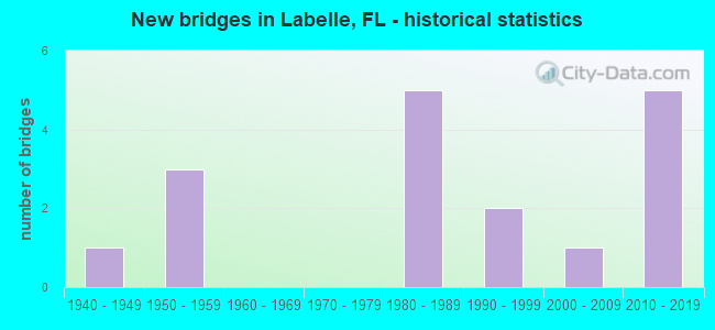
- New bridges - historical statistics
- 11940-1949
- 31950-1959
- 51980-1989
- 21990-1999
- 12000-2009
- 52010-2019
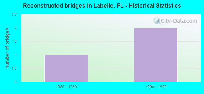
- Reconstructed bridges - Historical Statistics
- 11980-1989
- 21990-1999
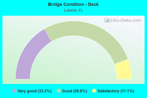
- Bridge Condition - Deck
- 33.3%Very good
- 55.6%Good
- 11.1%Satisfactory
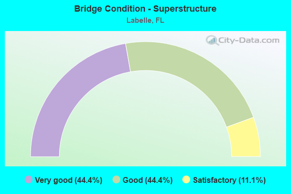
- Bridge Condition - Superstructure
- 44.4%Very good
- 44.4%Good
- 11.1%Satisfactory
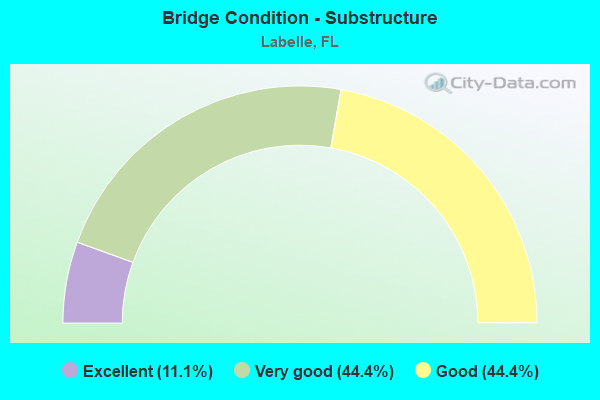
- Bridge Condition - Substructure
- 11.1%Excellent
- 44.4%Very good
- 44.4%Good
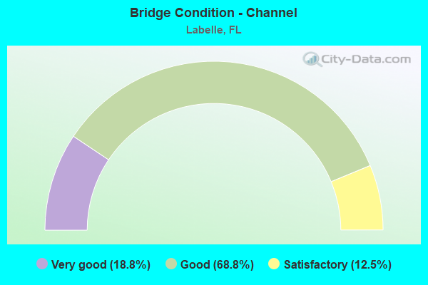
- Bridge Condition - Channel
- 18.8%Very good
- 68.8%Good
- 12.5%Satisfactory
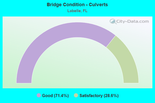
- Bridge Condition - Culverts
- 71.4%Good
- 28.6%Satisfactory
Find on map >> Show street view
Structure Number: 50043, Location: 0.1MILE EAST OF SR-29 (Lat: 26.812375, Lng: -81.410889), Route carried "on" structure: State highway 78, Year Built: 1958, Year Reconstructed: 1986, Status: Open, Structure Length: 0.81m (2.66ft), Average Daily Traffic: 3,400 (year 2020), Truck Traffic: 30%, Average Future Daily Traffic: 5,899 (year 2042), Design Load: H 15, Features Intersected: FLAG SLOUGH
Minimum Vertical Clearance: 30+ m (98+ ft), Kilometerpoint: 0.187, Lanes on structure: 2, Base Highway Network: Yes, Owner: State Highway Agency, Approaching Roadway Width: 9.8m (32.2ft), Skew: 1 degrees, Material/Design: Concrete, Design/Construction: Culvert, Number Of Spans In Main Unit: 3, Length of Maximum Span: 2.6m (8.5ft)
Condition: Channel: Satisfactory, Culverts: Satisfactory, Operating Rating: 56.2 metric tons, Method Used To Determine Operating Rating: Load Factor (LF), Inventory Rating: 33.7 metric tons, Method Used To Determine Inventory Rating: Load Factor (LF), Structural Evaluation: Equal to present minimum criteria, Waterway Adequacy: Equal to present minimum criteria, Approach Roadway Alignment: Equal to present desirable criteria, Designated Inspection Frequency: Every 24 months, Underwater Inspection Frequency: Every 24 months, Inspection Date: Febuary 2020, Underwater Inspection Date: January 2020
Find on map >> Show street view
Structure Number: 50941, Location: 0.6MI SOUTH OF SR-78 (Lat: 26.804992, Lng: -81.419253), Route carried "on" structure: State highway 29, Year Built: 1948, Year Reconstructed: 1999, Status: Open, Structure Length: 1.20m (3.94ft), Average Daily Traffic: 6,100 (year 2022), Truck Traffic: 31%, Average Future Daily Traffic: 10,584 (year 2042), Design Load: H 15, Features Intersected: N OKALOACOOCHEE RIVER
Minimum Vertical Clearance: 30+ m (98+ ft), Kilometerpoint: 2.971, Lanes on structure: 2, Base Highway Network: Yes, Owner: State Highway Agency, Approaching Roadway Width: 10.4m (34.1ft), Material/Design: Concrete, Design/Construction: Slab, Number Of Spans In Main Unit: 2, Length of Maximum Span: 6.0m (19.7ft), Curb-To-Curb Width: 13.3m (43.6ft), Out-to-Out Width: 14.1m (46.3ft)
Condition: Deck: Good, Superstructure: Good, Substructure: Good, Channel: Good, Operating Rating: 40.5 metric tons, Method Used To Determine Operating Rating: Load Factor (LF), Inventory Rating: 24.2 metric tons, Method Used To Determine Inventory Rating: Load Factor (LF), Structural Evaluation: Somewhat better than minimum adequacy, Deck Geometry: Somewhat better than minimum adequacy, Waterway Adequacy: Equal to present desirable criteria, Approach Roadway Alignment: Equal to present desirable criteria, Designated Inspection Frequency: Every 24 months, Underwater Inspection Frequency: Every 24 months, Inspection Date: Febuary 2022, Underwater Inspection Date: January 2022, Deck Structure Type: Concrete Cast-file-Place, Wearing Surface/Protective System: Wearing Surface: Bituminous
Find on map >> Show street view
Structure Number: 70033, Location: 0.5MI NORTH OF SR 80 (Lat: 26.769225, Lng: -81.437364), Route carried "on" structure: State highway 29, Year Built: 1959, Status: Open, Structure Length: 15.29m (50.16ft), Average Daily Traffic: 14,500 (year 2021), Truck Traffic: 16%, Average Future Daily Traffic: 25,158 (year 2041), Design Load: HL 93, Features Intersected: CALOOSAHATCHEE RIVER
Minimum Vertical Clearance: 30+ m (98+ ft), Kilometerpoint: 28.141, Lanes on structure: 2, Lanes under structure: 2, Base Highway Network: Yes, Owner: State Highway Agency, Approaching Roadway Width: 9.4m (30.8ft), Navigation Control: Yes ( Vertical Clearance: 7.0m (23.0ft), Horizontal Clearance: 29.2m (95.8ft)), Material/Design: Steel, Design/Construction: Movable - Bascule, Number Of Spans In Main Unit: 1, Number Of Approach Spans: 8, Length of Maximum Span: 31.9m (104.7ft), Curb or Sidewalk Widths: Left: 1.0m (3.3ft), Right: 1.0m (3.3ft), Curb-To-Curb Width: 8.5m (27.9ft), Out-to-Out Width: 11.3m (37.1ft)
Condition: Deck: Satisfactory, Superstructure: Satisfactory, Substructure: Good, Channel: Good, Operating Rating: 43.0 metric tons, Method Used To Determine Operating Rating: Load and Resistance Factor (LRFR), Inventory Rating: 33.2 metric tons, Method Used To Determine Inventory Rating: Load and Resistance Factor (LRFR), Structural Evaluation: Equal to present minimum criteria, Deck Geometry: Meets minimum limits, Underclear: Somewhat better than minimum adequacy, Waterway Adequacy: Equal to present desirable criteria, Approach Roadway Alignment: Equal to present desirable criteria, Designated Inspection Frequency: Every 24 months, Critical Feature Inspection Frequency: Every 12 months, Underwater Inspection Frequency: Every 24 months, Other Special Inspection Frequency: Every 12 months, Inspection Date: October 2021, Critical Feature Inspection Date: October 2021, Underwater Inspection Date: September 2021, Other Special Inspection Date: October 2021, Deck Structure Type: Concrete Cast-file-Place
Find on map >> Show street view
Structure Number: 70057, Location: 8.3 MI. S of SR-80 (Lat: 26.640911, Lng: -81.436294), Route carried "on" structure: State highway 29, Year Built: 1985, Status: Open, Structure Length: 1.33m (4.36ft), Average Daily Traffic: 5,600 (year 2021), Truck Traffic: 18%, Average Future Daily Traffic: 9,716 (year 2041), Design Load: HS 20+Mod, Features Intersected: ROBERTS CANAL
Minimum Vertical Clearance: 30.45m (99.90ft), Kilometerpoint: 13.889, Lanes on structure: 2, Base Highway Network: Yes, Owner: State Highway Agency, Approaching Roadway Width: 10.1m (33.1ft), Material/Design: Concrete, Design/Construction: Culvert, Number Of Spans In Main Unit: 4, Length of Maximum Span: 3.3m (10.8ft)
Condition: Channel: Good, Culverts: Good, Inventory Rating: 86.5 metric tons, Method Used To Determine Inventory Rating: Load Factor (LF), Structural Evaluation: Better than present minimum criteria, Waterway Adequacy: Superior to present desirable criteria, Approach Roadway Alignment: Equal to present desirable criteria, Designated Inspection Frequency: Every 24 months, Underwater Inspection Frequency: Every 23 months, Inspection Date: May 2021, Underwater Inspection Date: May 2021
Find on map >> Show street view
Structure Number: 70058, Location: 7.4 MI. S of SR-80 (Lat: 26.654742, Lng: -81.436161), Route carried "on" structure: State highway 29, Year Built: 1985, Status: Open, Structure Length: 1.17m (3.84ft), Average Daily Traffic: 6,000 (year 2021), Truck Traffic: 18%, Average Future Daily Traffic: 10,410 (year 2041), Design Load: HS 20+Mod, Features Intersected: SEARS RD DRAINAGE CANAL
Minimum Vertical Clearance: 30.45m (99.90ft), Kilometerpoint: 15.419, Lanes on structure: 2, Base Highway Network: Yes, Owner: State Highway Agency, Approaching Roadway Width: 10.1m (33.1ft), Material/Design: Concrete, Design/Construction: Culvert, Number Of Spans In Main Unit: 3, Length of Maximum Span: 4.0m (13.1ft), Curb-To-Curb Width: 24.8m (81.4ft), Out-to-Out Width: 25.6m (84.0ft)
Condition: Channel: Good, Culverts: Satisfactory, Operating Rating: 41.2 metric tons, Method Used To Determine Operating Rating: Load Factor (LF), Inventory Rating: 24.5 metric tons, Method Used To Determine Inventory Rating: Load Factor (LF), Structural Evaluation: Equal to present minimum criteria, Deck Geometry: Superior to present desirable criteria, Waterway Adequacy: Equal to present desirable criteria, Approach Roadway Alignment: Equal to present desirable criteria, Designated Inspection Frequency: Every 24 months, Underwater Inspection Frequency: Every 24 months, Inspection Date: May 2021, Underwater Inspection Date: May 2021, Deck Structure Type: Concrete Cast-file-Place, Wearing Surface/Protective System: Wearing Surface: Bituminous
Find on map >> Show street view
Structure Number: 70059, Location: 1.2 Mi. W of SR-29 (Lat: 26.756258, Lng: -81.454239), Route carried "on" structure: State highway 80, Year Built: 1985, Year Reconstructed: 1999, Status: Open, Structure Length: 0.84m (2.76ft), Average Daily Traffic: 14,400 (year 2021), Truck Traffic: 16%, Average Future Daily Traffic: 24,984 (year 2041), Design Load: HS 20+Mod, Features Intersected: BEE CREEK
Minimum Vertical Clearance: 30.45m (99.90ft), Kilometerpoint: 13.255, Lanes on structure: 4, Base Highway Network: Yes, Owner: State Highway Agency, Approaching Roadway Width: 21.0m (68.9ft), Skew: 1 degrees, Material/Design: Concrete, Design/Construction: Culvert, Number Of Spans In Main Unit: 3, Length of Maximum Span: 2.6m (8.5ft)
Condition: Channel: Satisfactory, Culverts: Good, Structural Evaluation: Better than present minimum criteria, Waterway Adequacy: Equal to present desirable criteria, Approach Roadway Alignment: Equal to present desirable criteria, Designated Inspection Frequency: Every 24 months, Inspection Date: May 2021
Find on map >> Show street view
Structure Number: 70062, Location: 2.7 MI. W of SR-29 (Lat: 26.737783, Lng: -81.471008), Route carried "on" structure: State highway 80, Year Built: 1999, Status: Open, Structure Length: 2.29m (7.51ft), Average Daily Traffic: 8,700 (year 2021), Truck Traffic: 18%, Average Future Daily Traffic: 15,094 (year 2041), Design Load: HS 20, Features Intersected: GRANDMAS GROVE CREEK
Minimum Vertical Clearance: 30.45m (99.90ft), Kilometerpoint: 10.570, Lanes on structure: 2, Base Highway Network: Yes, Owner: State Highway Agency, Approaching Roadway Width: 8.8m (28.9ft), Material/Design: Concrete continuous, Design/Construction: Slab, Number Of Spans In Main Unit: 3, Length of Maximum Span: 8.8m (28.9ft), Curb-To-Curb Width: 12.2m (40.0ft), Out-to-Out Width: 13.1m (43.0ft)
Condition: Deck: Good, Superstructure: Good, Substructure: Good, Channel: Good, Operating Rating: 58.2 metric tons, Method Used To Determine Operating Rating: Load Factor (LF), Inventory Rating: 34.9 metric tons, Method Used To Determine Inventory Rating: Load Factor (LF), Structural Evaluation: Better than present minimum criteria, Deck Geometry: Better than present minimum criteria, Waterway Adequacy: Equal to present desirable criteria, Approach Roadway Alignment: Equal to present desirable criteria, Designated Inspection Frequency: Every 24 months, Inspection Date: May 2021, Deck Structure Type: Concrete Cast-file-Place
Find on map >> Show street view
Structure Number: 70063, Location: 2.7 MI. W of SR-29 (Lat: 26.737603, Lng: -81.470856), Route carried "on" structure: State highway 80, Year Built: 1999, Status: Open, Structure Length: 2.29m (7.51ft), Average Daily Traffic: 8,700 (year 2021), Truck Traffic: 18%, Average Future Daily Traffic: 15,094 (year 2041), Design Load: HS 20, Features Intersected: GRANDMAS GROVE CREEK
Minimum Vertical Clearance: 30+ m (98+ ft), Kilometerpoint: 10.570, Lanes on structure: 2, Base Highway Network: Yes, Owner: State Highway Agency, Approaching Roadway Width: 8.8m (28.9ft), Material/Design: Concrete continuous, Design/Construction: Slab, Number Of Spans In Main Unit: 3, Length of Maximum Span: 8.8m (28.9ft), Curb-To-Curb Width: 15.8m (51.8ft), Out-to-Out Width: 16.8m (55.1ft)
Condition: Deck: Good, Superstructure: Good, Substructure: Very good, Channel: Very good, Operating Rating: 58.8 metric tons, Method Used To Determine Operating Rating: Load Factor (LF), Inventory Rating: 35.3 metric tons, Method Used To Determine Inventory Rating: Load Factor (LF), Structural Evaluation: Better than present minimum criteria, Deck Geometry: Superior to present desirable criteria, Waterway Adequacy: Equal to present desirable criteria, Approach Roadway Alignment: Equal to present desirable criteria, Designated Inspection Frequency: Every 24 months, Inspection Date: May 2021, Deck Structure Type: Concrete Cast-file-Place
Find on map >> Show street view
Structure Number: 70069, Location: 2 MI. W of SR-29 (Lat: 26.745739, Lng: -81.461822), Route carried "on" structure: State highway 80, Year Built: 2000, Status: Open, Structure Length: 0.88m (2.89ft), Average Daily Traffic: 17,400 (year 2021), Truck Traffic: 18%, Average Future Daily Traffic: 30,189 (year 2041), Design Load: HS 20, Features Intersected: PLANT CREEK
Minimum Vertical Clearance: 30.45m (99.90ft), Kilometerpoint: 11.858, Lanes on structure: 4, Base Highway Network: Yes, Owner: State Highway Agency, Approaching Roadway Width: 15.8m (51.8ft), Skew: 20 degrees, Material/Design: Concrete, Design/Construction: Culvert, Number Of Spans In Main Unit: 3, Length of Maximum Span: 3.1m (10.2ft)
Condition: Channel: Good, Culverts: Good, Inventory Rating: 54.8 metric tons, Method Used To Determine Inventory Rating: Load Factor (LF), Structural Evaluation: Better than present minimum criteria, Waterway Adequacy: Better than present minimum criteria, Approach Roadway Alignment: Equal to present desirable criteria, Designated Inspection Frequency: Every 24 months, Inspection Date: May 2021
Find on map >> Show street view
Structure Number: 70073, Location: 2.3MI EAST OF SR-29 (Lat: 26.762972, Lng: -81.400139), Route carried "on" structure: State highway 80, Year Built: 2010, Status: Open, Structure Length: 3.54m (11.61ft), Average Daily Traffic: 5,550 (year 2020), Truck Traffic: 12%, Average Future Daily Traffic: 9,629 (year 2042), Design Load: HL 93, Features Intersected: OKALOACOOCHEE BRANCH
Minimum Vertical Clearance: 30.45m (99.90ft), Kilometerpoint: 18.870, Lanes on structure: 2, Base Highway Network: Yes, Owner: State Highway Agency, Approaching Roadway Width: 12.3m (40.4ft), Material/Design: Prestressed concrete, Design/Construction: Stringer/Multi-beam, Number Of Spans In Main Unit: 1, Length of Maximum Span: 35.4m (116.1ft), Curb-To-Curb Width: 12.3m (40.4ft), Out-to-Out Width: 13.1m (43.0ft)
Condition: Deck: Very good, Superstructure: Very good, Substructure: Excellent, Channel: Good, Operating Rating: 48.2 metric tons, Method Used To Determine Operating Rating: Load and Resistance Factor (LRFR), Inventory Rating: 44.1 metric tons, Method Used To Determine Inventory Rating: Load and Resistance Factor (LRFR), Structural Evaluation: Equal to present desirable criteria, Deck Geometry: Better than present minimum criteria, Waterway Adequacy: Equal to present desirable criteria, Approach Roadway Alignment: Equal to present desirable criteria, Designated Inspection Frequency: Every 24 months, Inspection Date: March 2020, Deck Structure Type: Concrete Cast-file-Place, Wearing Surface/Protective System: Wearing Surface: Monolithic Concrete
Find on map >> Show street view
Structure Number: 70074, Location: 2.3MI EAST OF SR-29 (Lat: 26.763083, Lng: -81.400000), Route carried "on" structure: State highway 80, Year Built: 2010, Status: Open, Structure Length: 3.54m (11.61ft), Average Daily Traffic: 5,550 (year 2020), Truck Traffic: 12%, Average Future Daily Traffic: 9,629 (year 2042), Design Load: HL 93, Features Intersected: Okaloacoochee Branch
Minimum Vertical Clearance: 30.18m (99.02ft), Kilometerpoint: 18.870, Lanes on structure: 2, Base Highway Network: Yes, Owner: State Highway Agency, Approaching Roadway Width: 12.0m (39.4ft), Material/Design: Prestressed concrete, Design/Construction: Stringer/Multi-beam, Number Of Spans In Main Unit: 1, Length of Maximum Span: 35.4m (116.1ft), Curb or Sidewalk Widths: Left: 0.0m, Right: 1.5m (4.9ft), Curb-To-Curb Width: 12.0m (39.4ft), Out-to-Out Width: 14.9m (48.9ft)
Condition: Deck: Very good, Superstructure: Very good, Substructure: Very good, Channel: Good, Operating Rating: 51.4 metric tons, Method Used To Determine Operating Rating: Load and Resistance Factor (LRFR), Inventory Rating: 46.4 metric tons, Method Used To Determine Inventory Rating: Load and Resistance Factor (LRFR), Structural Evaluation: Equal to present desirable criteria, Deck Geometry: Better than present minimum criteria, Waterway Adequacy: Equal to present desirable criteria, Approach Roadway Alignment: Equal to present desirable criteria, Designated Inspection Frequency: Every 24 months, Inspection Date: March 2020, Deck Structure Type: Concrete Cast-file-Place, Wearing Surface/Protective System: Wearing Surface: Monolithic Concrete
Find on map >> Show street view
Structure Number: 70075, Location: 7.1 MI E/O SR-29 (Lat: 26.768278, Lng: -81.324361), Route carried "on" structure: State highway 80, Year Built: 2013, Status: Open, Structure Length: 3.84m (12.60ft), Average Daily Traffic: 5,550 (year 2021), Truck Traffic: 12%, Average Future Daily Traffic: 9,629 (year 2041), Design Load: HL 93, Features Intersected: C-1 CANAL
Minimum Vertical Clearance: 30.45m (99.90ft), Kilometerpoint: 26.538, Lanes on structure: 2, Base Highway Network: Yes, Owner: State Highway Agency, Approaching Roadway Width: 10.2m (33.5ft), Material/Design: Prestressed concrete, Design/Construction: Stringer/Multi-beam, Number Of Spans In Main Unit: 1, Length of Maximum Span: 38.4m (126.0ft), Curb or Sidewalk Widths: Left: 0.0m, Right: 1.6m (5.2ft), Curb-To-Curb Width: 12.1m (39.7ft), Out-to-Out Width: 15.8m (51.8ft)
Condition: Deck: Very good, Superstructure: Very good, Substructure: Very good, Channel: Very good, Operating Rating: 69.6 metric tons, Method Used To Determine Operating Rating: Load and Resistance Factor (LRFR), Inventory Rating: 53.5 metric tons, Method Used To Determine Inventory Rating: Load and Resistance Factor (LRFR), Structural Evaluation: Equal to present desirable criteria, Deck Geometry: Better than present minimum criteria, Waterway Adequacy: Equal to present desirable criteria, Approach Roadway Alignment: Equal to present desirable criteria, Designated Inspection Frequency: Every 24 months, Inspection Date: June 2021, Deck Structure Type: Concrete Cast-file-Place, Wearing Surface/Protective System: Wearing Surface: Monolithic Concrete
Find on map >> Show street view
Structure Number: 70076, Location: 7.1 MI E/O SR-29 (Lat: 26.768472, Lng: -81.324306), Route carried "on" structure: State highway 80, Year Built: 2013, Status: Open, Structure Length: 3.84m (12.60ft), Average Daily Traffic: 5,550 (year 2021), Truck Traffic: 12%, Average Future Daily Traffic: 9,629 (year 2041), Design Load: HL 93, Features Intersected: C-1 CANAL
Minimum Vertical Clearance: 30.45m (99.90ft), Kilometerpoint: 26.538, Lanes on structure: 2, Base Highway Network: Yes, Owner: State Highway Agency, Approaching Roadway Width: 10.4m (34.1ft), Material/Design: Prestressed concrete, Design/Construction: Stringer/Multi-beam, Number Of Spans In Main Unit: 1, Length of Maximum Span: 38.4m (126.0ft), Curb-To-Curb Width: 12.2m (40.0ft), Out-to-Out Width: 13.1m (43.0ft)
Condition: Deck: Good, Superstructure: Very good, Substructure: Very good, Channel: Very good, Operating Rating: 58.8 metric tons, Method Used To Determine Operating Rating: Load and Resistance Factor (LRFR), Inventory Rating: 48.6 metric tons, Method Used To Determine Inventory Rating: Load and Resistance Factor (LRFR), Structural Evaluation: Equal to present desirable criteria, Deck Geometry: Better than present minimum criteria, Waterway Adequacy: Equal to present desirable criteria, Approach Roadway Alignment: Equal to present desirable criteria, Designated Inspection Frequency: Every 24 months, Inspection Date: June 2021, Deck Structure Type: Concrete Cast-file-Place
Find on map >> Show street view
Structure Number: 70077, Location: 4.1 MI E/O SR-29 (Lat: 26.768472, Lng: -81.373806), Route carried "on" structure: State highway 80, Year Built: 2013, Status: Open, Structure Length: 0.69m (2.26ft), Average Daily Traffic: 11,100 (year 2021), Truck Traffic: 12%, Average Future Daily Traffic: 19,258 (year 2041), Design Load: HL 93, Features Intersected: CEDARWOOD CANAL
Minimum Vertical Clearance: 30+ m (98+ ft), Kilometerpoint: 21.651, Lanes on structure: 5, Base Highway Network: Yes, Owner: State Highway Agency, Approaching Roadway Width: 21.8m (71.5ft), Skew: 20 degrees, Material/Design: Concrete, Design/Construction: Culvert, Number Of Spans In Main Unit: 3, Length of Maximum Span: 2.1m (6.9ft)
Condition: Channel: Good, Culverts: Good, Inventory Rating: 80.4 metric tons, Method Used To Determine Inventory Rating: Load and Resistance Factor (LRFR), Structural Evaluation: Better than present minimum criteria, Waterway Adequacy: Equal to present desirable criteria, Approach Roadway Alignment: Equal to present desirable criteria, Designated Inspection Frequency: Every 24 months, Inspection Date: June 2021
Find on map >> Show street view
Structure Number: 74025, Location: 0.9MI E of SR-29 (Lat: 26.746986, Lng: -81.421789), Route carried "on" structure: Alternate County highway 80A, Year Built: 1988, Status: Open, Structure Length: 0.85m (2.79ft), Average Daily Traffic: 3,230 (year 2021), Truck Traffic: 2%, Average Future Daily Traffic: 4,038 (year 2041), Features Intersected: DEVILS DITCH
Minimum Vertical Clearance: 30+ m (98+ ft), Kilometerpoint: 1.606, Lanes on structure: 2, Owner: County Highway Agency, Approaching Roadway Width: 7.2m (23.6ft), Material/Design: Concrete, Design/Construction: Culvert, Number Of Spans In Main Unit: 3, Length of Maximum Span: 3.0m (9.8ft)
Condition: Channel: Good, Culverts: Good, Operating Rating: 45.1 metric tons, Method Used To Determine Operating Rating: Load and Resistance Factor (LRFR), Inventory Rating: 34.9 metric tons, Method Used To Determine Inventory Rating: Load and Resistance Factor (LRFR), Structural Evaluation: Better than present minimum criteria, Waterway Adequacy: Better than present minimum criteria, Approach Roadway Alignment: Equal to present desirable criteria, Designated Inspection Frequency: Every 24 months, Inspection Date: June 2021
Find on map >> Show street view
Structure Number: 7403, Location: 0.1MI E OF CALOOSA ESTATE (Lat: 26.765325, Lng: -81.459183), Route carried "on" structure: County highway , Year Built: 1980, Status: Posted for load, Structure Length: 1.26m (4.13ft), Average Daily Traffic: 30 (year 2021), Truck Traffic: 1%, Average Future Daily Traffic: 36 (year 2041), Features Intersected: POLLYWOG CREEK, Facility Carried by Structure: POLLYWOG POINT
Minimum Vertical Clearance: 30+ m (98+ ft), Kilometerpoint: 0.000, Lanes on structure: 1, Owner: County Highway Agency, Approaching Roadway Width: 3.4m (11.2ft), Material/Design: Aluminum, Iron, Design/Construction: Truss - Deck, Number Of Spans In Main Unit: 1, Length of Maximum Span: 12.6m (41.3ft), Curb-To-Curb Width: 3.7m (12.1ft), Out-to-Out Width: 4.3m (14.1ft)
Condition: Deck: Good, Superstructure: Good, Substructure: Good, Channel: Good, Operating Rating: 23.9 metric tons, Method Used To Determine Operating Rating: Load Factor (LF), Inventory Rating: 14.3 metric tons, Method Used To Determine Inventory Rating: Load Factor (LF), Structural Evaluation: Meets minimum limits, Deck Geometry: Meets minimum limits, Waterway Adequacy: Better than present minimum criteria, Approach Roadway Alignment: Equal to present desirable criteria, Bridge Posting: Required (Relationship of Operating Rating to Maximum Legal Load: 30.0 - 39.9% below), Designated Inspection Frequency: Every 24 months, Critical Feature Inspection Frequency: Every 12 months, Other Special Inspection Frequency: Every 12 months, Inspection Date: June 2021, Critical Feature Inspection Date: June 2021, Other Special Inspection Date: June 2021, Deck Structure Type: Concrete Cast-file-Place, Wearing Surface/Protective System: Wearing Surface: Bituminous
Find on map >> Show street view
Structure Number: 70033, Location: 0.5MI NORTH OF SR 80 (Lat: 26.769225, Lng: -81.437364), Route carried "under" structure: City street , Year Built: 1959, Structure Length: 0. m, Average Daily Traffic: 101 (year 2021), Truck Traffic: 2%, Features Intersected: CALOOSAHATCHEE RIVER, Facility Carried by Structure: SR 29 (BRIDGE ST)
Minimum Vertical Clearance: 4.42m (14.50ft), Kilometerpoint: 0.000, Lanes on structure: 2, Lanes under structure: 2, Material/Design: Steel, Design/Construction: Movable - Bascule, Length of Maximum Span: 31.9m (104.7ft)