Bridge Statistics for Lake Jackson, Texas (TX)
Condition, Traffic, Stress, Structural Evaluation, Project Costs
- National Bridge Inventory (NBI) Statistics
- 80Number of bridges
- 2,969ft / 905mTotal length
- $2,337,000Total costs
- 1,100,852Total average daily traffic
- 122,920Total average daily truck traffic
- National Bridge Inventory (NBI) Registered Bridges for Lake Jackson
- No street view available for this location
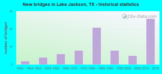
- New bridges - historical statistics
- 21940-1949
- 41950-1959
- 61960-1969
- 81970-1979
- 211980-1989
- 81990-1999
- 52000-2009
- 262010-2019
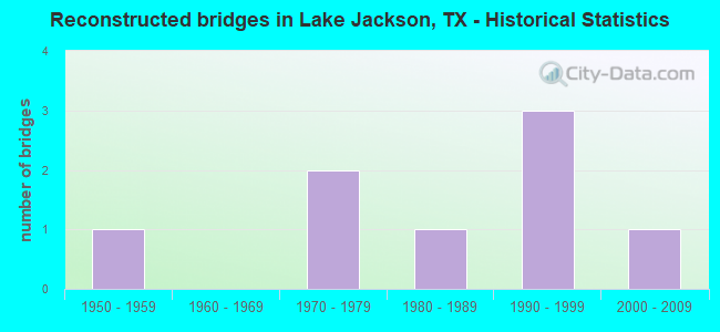
- Reconstructed bridges - Historical Statistics
- 11950-1959
- 01960-1969
- 21970-1979
- 11980-1989
- 31990-1999
- 12000-2009

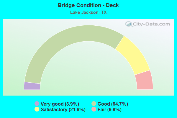
- Bridge Condition - Deck
- 3.9%Very good
- 64.7%Good
- 21.6%Satisfactory
- 9.8%Fair
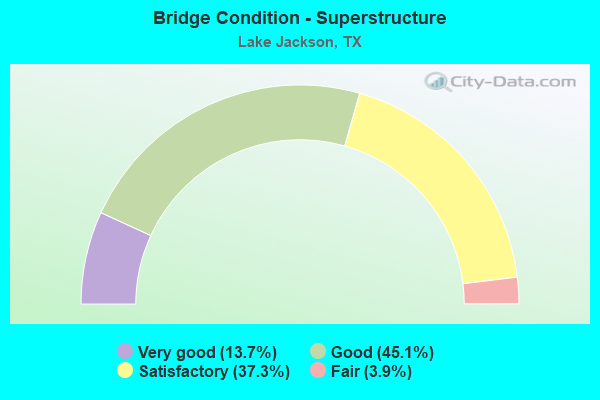
- Bridge Condition - Superstructure
- 13.7%Very good
- 45.1%Good
- 37.3%Satisfactory
- 3.9%Fair
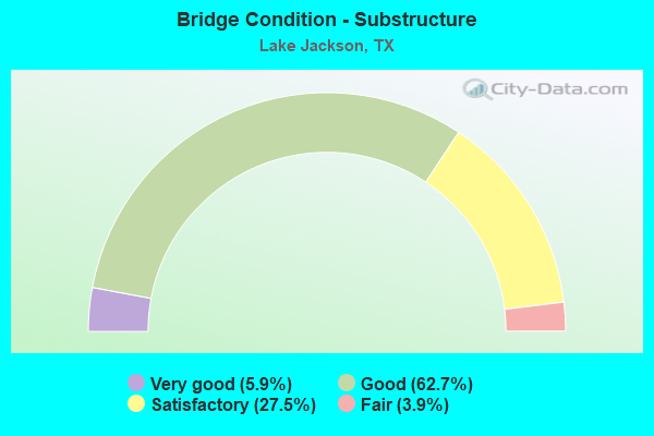
- Bridge Condition - Substructure
- 5.9%Very good
- 62.7%Good
- 27.5%Satisfactory
- 3.9%Fair
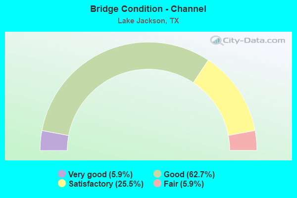
- Bridge Condition - Channel
- 5.9%Very good
- 62.7%Good
- 25.5%Satisfactory
- 5.9%Fair
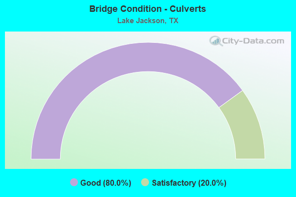
- Bridge Condition - Culverts
- 80.0%Good
- 20.0%Satisfactory
Find on map >> Show street view
Structure Number: 120200152401073, Location: 0.8 MI SE of JCT. SH 288 (Lat: 29.036411, Lng: -95.450200), Route carried "on" structure: State highway 332, Year Built: 2012, Status: Open, Structure Length: 31.61m (103.71ft), Average Daily Traffic: 30,690 (year 2010), Truck Traffic: 16%, Average Future Daily Traffic: 42,970 (year 2030), Design Load: HL 93, Features Intersected: Oak Dr.
Minimum Vertical Clearance: 30+ m (98+ ft), Kilometerpoint: 14.199, Lanes on structure: 2, Lanes under structure: 6, Owner: State Highway Agency, Approaching Roadway Width: 12.2m (40.0ft), Material/Design: Prestressed concrete, Design/Construction: Stringer/Multi-beam, Number Of Spans In Main Unit: 10, Length of Maximum Span: 33.5m (109.9ft), Curb-To-Curb Width: 12.2m (40.0ft), Out-to-Out Width: 12.9m (42.3ft)
Condition: Deck: Good, Superstructure: Good, Substructure: Good, Operating Rating: 54.4 metric tons, Method Used To Determine Operating Rating: Assigned ratings based on Load and Resistance Factor Design (LRFD) reported in metric tons, Inventory Rating: 32.7 metric tons, Method Used To Determine Inventory Rating: Assigned ratings based on Load and Resistance Factor Design (LRFD) reported in metric tons, Structural Evaluation: Better than present minimum criteria, Deck Geometry: Better than present minimum criteria, Underclear: Meets minimum limits, Approach Roadway Alignment: Equal to present desirable criteria, Designated Inspection Frequency: Every 24 months, Inspection Date: December 2020, Deck Structure Type: Concrete Precast Panels
Find on map >> Show street view
Structure Number: 120200152401074, Location: 0.8 MI SE of JCT. SH 288 (Lat: 29.035281, Lng: -95.447419), Route carried "on" structure: State highway 332, Year Built: 2012, Status: Open, Structure Length: 31.39m (102.99ft), Average Daily Traffic: 30,690 (year 2010), Truck Traffic: 16%, Average Future Daily Traffic: 42,970 (year 2030), Design Load: HL 93, Features Intersected: Oak Dr.
Minimum Vertical Clearance: 30+ m (98+ ft), Kilometerpoint: 14.199, Lanes on structure: 2, Lanes under structure: 6, Owner: State Highway Agency, Approaching Roadway Width: 12.2m (40.0ft), Material/Design: Prestressed concrete, Design/Construction: Stringer/Multi-beam, Number Of Spans In Main Unit: 10, Length of Maximum Span: 33.5m (109.9ft), Curb-To-Curb Width: 12.2m (40.0ft), Out-to-Out Width: 12.9m (42.3ft)
Condition: Deck: Good, Superstructure: Good, Substructure: Very good, Operating Rating: 54.4 metric tons, Method Used To Determine Operating Rating: Assigned ratings based on Load and Resistance Factor Design (LRFD) reported in metric tons, Inventory Rating: 32.7 metric tons, Method Used To Determine Inventory Rating: Assigned ratings based on Load and Resistance Factor Design (LRFD) reported in metric tons, Structural Evaluation: Better than present minimum criteria, Deck Geometry: Better than present minimum criteria, Underclear: Meets minimum limits, Approach Roadway Alignment: Equal to present desirable criteria, Designated Inspection Frequency: Every 24 months, Inspection Date: December 2020, Deck Structure Type: Concrete Precast Panels
Find on map >> Show street view
Structure Number: 120200152401075, Location: 2.1 MI SE of JCT SH 288 (Lat: 29.019881, Lng: -95.434311), Route carried "on" structure: Bypass State highway 332, Year Built: 2012, Status: Open, Structure Length: 29.63m (97.21ft), Average Daily Traffic: 30,690 (year 2010), Truck Traffic: 19%, Average Future Daily Traffic: 42,970 (year 2030), Design Load: HL 93, Features Intersected: Plantation Dr.
Minimum Vertical Clearance: 30+ m (98+ ft), Kilometerpoint: 16.493, Lanes on structure: 2, Lanes under structure: 6, Owner: State Highway Agency, Approaching Roadway Width: 12.2m (40.0ft), Material/Design: Prestressed concrete, Design/Construction: Stringer/Multi-beam, Number Of Spans In Main Unit: 9, Length of Maximum Span: 37.8m (124.0ft), Curb-To-Curb Width: 12.2m (40.0ft), Out-to-Out Width: 12.9m (42.3ft)
Condition: Deck: Good, Superstructure: Good, Substructure: Good, Operating Rating: 54.4 metric tons, Method Used To Determine Operating Rating: Assigned ratings based on Load and Resistance Factor Design (LRFD) reported in metric tons, Inventory Rating: 32.7 metric tons, Method Used To Determine Inventory Rating: Assigned ratings based on Load and Resistance Factor Design (LRFD) reported in metric tons, Structural Evaluation: Better than present minimum criteria, Deck Geometry: Better than present minimum criteria, Underclear: Superior to present desirable criteria, Approach Roadway Alignment: Equal to present desirable criteria, Designated Inspection Frequency: Every 24 months, Inspection Date: December 2020, Deck Structure Type: Concrete Precast Panels
Find on map >> Show street view
Structure Number: 120200152401076, Location: 2.1 MI SE of JCT SH 288 (Lat: 29.021989, Lng: -95.435911), Route carried "on" structure: Bypass State highway 332, Year Built: 2012, Status: Open, Structure Length: 29.75m (97.60ft), Average Daily Traffic: 30,690 (year 2010), Truck Traffic: 16%, Average Future Daily Traffic: 42,970 (year 2030), Design Load: HL 93, Features Intersected: Plantation Dr.
Minimum Vertical Clearance: 30+ m (98+ ft), Kilometerpoint: 16.493, Lanes on structure: 2, Lanes under structure: 6, Owner: State Highway Agency, Approaching Roadway Width: 12.2m (40.0ft), Material/Design: Prestressed concrete, Design/Construction: Stringer/Multi-beam, Number Of Spans In Main Unit: 9, Length of Maximum Span: 37.8m (124.0ft), Curb-To-Curb Width: 12.2m (40.0ft), Out-to-Out Width: 12.9m (42.3ft)
Condition: Deck: Good, Superstructure: Good, Substructure: Good, Operating Rating: 54.4 metric tons, Method Used To Determine Operating Rating: Assigned ratings based on Load and Resistance Factor Design (LRFD) reported in metric tons, Inventory Rating: 32.7 metric tons, Method Used To Determine Inventory Rating: Assigned ratings based on Load and Resistance Factor Design (LRFD) reported in metric tons, Structural Evaluation: Better than present minimum criteria, Deck Geometry: Better than present minimum criteria, Underclear: Superior to present desirable criteria, Approach Roadway Alignment: Equal to present desirable criteria, Designated Inspection Frequency: Every 24 months, Inspection Date: December 2020, Deck Structure Type: Concrete Precast Panels
Find on map >> Show street view
Structure Number: 120200152401078, Location: 3.4 MI SE of JCT SH 288 (Lat: 29.010619, Lng: -95.421789), Route carried "on" structure: State highway 332, Year Built: 2012, Status: Open, Structure Length: 26.27m (86.19ft), Average Daily Traffic: 27,000 (year 2010), Truck Traffic: 16%, Average Future Daily Traffic: 37,800 (year 2030), Design Load: HL 93, Features Intersected: Dixie Dr.
Minimum Vertical Clearance: 30+ m (98+ ft), Kilometerpoint: 18.443, Lanes on structure: 2, Lanes under structure: 6, Owner: State Highway Agency, Approaching Roadway Width: 12.2m (40.0ft), Material/Design: Prestressed concrete, Design/Construction: Stringer/Multi-beam, Number Of Spans In Main Unit: 8, Length of Maximum Span: 37.5m (123.0ft), Curb-To-Curb Width: 12.2m (40.0ft), Out-to-Out Width: 12.9m (42.3ft)
Condition: Deck: Good, Superstructure: Good, Substructure: Very good, Operating Rating: 54.4 metric tons, Method Used To Determine Operating Rating: Assigned ratings based on Load and Resistance Factor Design (LRFD) reported in metric tons, Inventory Rating: 32.7 metric tons, Method Used To Determine Inventory Rating: Assigned ratings based on Load and Resistance Factor Design (LRFD) reported in metric tons, Structural Evaluation: Better than present minimum criteria, Deck Geometry: Better than present minimum criteria, Underclear: Superior to present desirable criteria, Approach Roadway Alignment: Equal to present desirable criteria, Designated Inspection Frequency: Every 24 months, Inspection Date: December 2020, Deck Structure Type: Concrete Precast Panels
Find on map >> Show street view
Structure Number: 120200252302013, Location: 1.50 MI E OF SH 288 (Lat: 29.064006, Lng: -95.430947), Route carried "on" structure: State highway 2004, Year Built: 1965, Year Reconstructed: 2011, Status: Open, Structure Length: 0.70m (2.30ft), Average Daily Traffic: 13,676 (year 2020), Truck Traffic: 4%, Average Future Daily Traffic: 15,390 (year 2033), Features Intersected: DRAINAGE DITCH
Minimum Vertical Clearance: 30+ m (98+ ft), Kilometerpoint: 40.974, Lanes on structure: 9, Owner: State Highway Agency, Approaching Roadway Width: 48.8m (160.1ft), Material/Design: Concrete, Design/Construction: Culvert, Number Of Spans In Main Unit: 3, Length of Maximum Span: 2.1m (6.9ft)
Condition: Channel: Good, Culverts: Good, Operating Rating: 39.9 metric tons, Method Used To Determine Operating Rating: Load Factor (LF), Inventory Rating: 23.6 metric tons, Method Used To Determine Inventory Rating: Load Factor (LF), Structural Evaluation: Somewhat better than minimum adequacy, Waterway Adequacy: Equal to present minimum criteria, Approach Roadway Alignment: Equal to present desirable criteria, Designated Inspection Frequency: Every 24 months, Inspection Date: December 2020
Find on map >> Show street view
Structure Number: 120200252302014, Location: 0.65 MI NE OF SH 332 (Lat: 29.053206, Lng: -95.463111), Route carried "on" structure: State highway 2004, Year Built: 1965, Year Reconstructed: 1999, Status: Open, Structure Length: 13.72m (45.01ft), Average Daily Traffic: 8,008 (year 2020), Truck Traffic: 7%, Average Future Daily Traffic: 8,400 (year 2033), Features Intersected: OYSTER CREEK
Minimum Vertical Clearance: 30+ m (98+ ft), Kilometerpoint: 44.368, Lanes on structure: 2, Owner: State Highway Agency, Approaching Roadway Width: 17.4m (57.1ft), Skew: 4 degrees, Material/Design: Prestressed concrete, Design/Construction: Stringer/Multi-beam, Number Of Spans In Main Unit: 8, Length of Maximum Span: 17.1m (56.1ft), Curb-To-Curb Width: 17.3m (56.8ft), Out-to-Out Width: 18.1m (59.4ft)
Condition: Deck: Good, Superstructure: Satisfactory, Substructure: Satisfactory, Channel: Satisfactory, Operating Rating: 32.7 metric tons, Method Used To Determine Operating Rating: Field evaluation and documented engineering judgment, Inventory Rating: 24.5 metric tons, Method Used To Determine Inventory Rating: Field evaluation and documented engineering judgment, Structural Evaluation: Equal to present minimum criteria, Deck Geometry: Superior to present desirable criteria, Waterway Adequacy: Equal to present minimum criteria, Approach Roadway Alignment: Equal to present desirable criteria, Length Of Structure Improvement: 13.72m (45.01ft), Designated Inspection Frequency: Every 24 months, Underwater Inspection Frequency: Every 60 months, Inspection Date: November 2020, Underwater Inspection Date: January 2019, Bridge Improvement Cost: $250,000, Roadway Improvement Cost: $63,000, Total Project Cost: $313,000, Deck Structure Type: Concrete Cast-file-Place
Find on map >> Show street view
Structure Number: 120200252302016, Location: 0.65 MI S OF SH 332 (Lat: 29.037253, Lng: -95.471311), Route carried "on" structure: State highway 2004, Year Built: 1981, Status: Open, Structure Length: 7.92m (25.98ft), Average Daily Traffic: 7,571 (year 2020), Truck Traffic: 6%, Average Future Daily Traffic: 8,730 (year 2033), Design Load: HS 20, Features Intersected: DOW FRESH WATER CANAL
Minimum Vertical Clearance: 30+ m (98+ ft), Kilometerpoint: 46.631, Lanes on structure: 2, Owner: State Highway Agency, Approaching Roadway Width: 12.2m (40.0ft), Skew: 4 degrees, Material/Design: Prestressed concrete, Design/Construction: Stringer/Multi-beam, Number Of Spans In Main Unit: 3, Length of Maximum Span: 31.1m (102.0ft), Curb-To-Curb Width: 13.2m (43.3ft), Out-to-Out Width: 15.1m (49.5ft)
Condition: Deck: Good, Superstructure: Good, Substructure: Good, Channel: Good, Operating Rating: 54.4 metric tons, Method Used To Determine Operating Rating: Assigned rating based on Load Factor Design (LFD) reported in metric tons, Inventory Rating: 32.7 metric tons, Method Used To Determine Inventory Rating: Assigned rating based on Load Factor Design (LFD) reported in metric tons, Structural Evaluation: Better than present minimum criteria, Deck Geometry: Somewhat better than minimum adequacy, Waterway Adequacy: Superior to present desirable criteria, Approach Roadway Alignment: Equal to present desirable criteria, Designated Inspection Frequency: Every 24 months, Inspection Date: November 2020, Deck Structure Type: Concrete Cast-file-Place
Find on map >> Show street view
Structure Number: 120200252302017, Location: 1.35 MI S OF SH 332 (Lat: 29.028889, Lng: -95.475814), Route carried "on" structure: State highway 2004, Year Built: 1988, Status: Open, Structure Length: 43.28m (141.99ft), Average Daily Traffic: 7,571 (year 2020), Truck Traffic: 6%, Average Future Daily Traffic: 8,730 (year 2033), Design Load: HS 20, Features Intersected: BRAZOS RIVER
Minimum Vertical Clearance: 30+ m (98+ ft), Kilometerpoint: 47.707, Lanes on structure: 2, Owner: State Highway Agency, Approaching Roadway Width: 12.2m (40.0ft), Skew: 3 degrees, Material/Design: Prestressed concrete, Design/Construction: Stringer/Multi-beam, Number Of Spans In Main Unit: 5, Number Of Approach Spans: 6, Length of Maximum Span: 42.7m (140.1ft), Curb-To-Curb Width: 13.2m (43.3ft), Out-to-Out Width: 14.1m (46.3ft)
Condition: Deck: Satisfactory, Superstructure: Satisfactory, Substructure: Satisfactory, Channel: Fair, Operating Rating: 54.4 metric tons, Method Used To Determine Operating Rating: Assigned rating based on Load Factor Design (LFD) reported in metric tons, Inventory Rating: 32.7 metric tons, Method Used To Determine Inventory Rating: Assigned rating based on Load Factor Design (LFD) reported in metric tons, Structural Evaluation: Equal to present minimum criteria, Deck Geometry: Somewhat better than minimum adequacy, Waterway Adequacy: Equal to present desirable criteria, Approach Roadway Alignment: Equal to present desirable criteria, Designated Inspection Frequency: Every 24 months, Underwater Inspection Frequency: Every 60 months, Inspection Date: November 2020, Underwater Inspection Date: Febuary 2019, Deck Structure Type: Concrete Precast Panels
Find on map >> Show street view
Structure Number: 120200252302018, Location: 2.55 MI S OF SH 332 (Lat: 29.012956, Lng: -95.484197), Route carried "on" structure: State highway 2004, Year Built: 1988, Status: Open, Structure Length: 36.58m (120.01ft), Average Daily Traffic: 10,021 (year 2016), Truck Traffic: 6%, Average Future Daily Traffic: 11,820 (year 2033), Design Load: HS 20, Features Intersected: JONES CREEK
Minimum Vertical Clearance: 30+ m (98+ ft), Kilometerpoint: 49.658, Lanes on structure: 2, Owner: State Highway Agency, Approaching Roadway Width: 12.2m (40.0ft), Material/Design: Concrete, Design/Construction: Stringer/Multi-beam, Number Of Spans In Main Unit: 30, Length of Maximum Span: 12.2m (40.0ft), Curb-To-Curb Width: 12.0m (39.4ft), Out-to-Out Width: 12.9m (42.3ft)
Condition: Deck: Satisfactory, Superstructure: Satisfactory, Substructure: Good, Channel: Good, Operating Rating: 68.0 metric tons, Method Used To Determine Operating Rating: Load Factor (LF), Inventory Rating: 40.8 metric tons, Method Used To Determine Inventory Rating: Load Factor (LF), Structural Evaluation: Equal to present minimum criteria, Deck Geometry: Somewhat better than minimum adequacy, Waterway Adequacy: Superior to present desirable criteria, Approach Roadway Alignment: Equal to present desirable criteria, Designated Inspection Frequency: Every 24 months, Inspection Date: November 2020, Deck Structure Type: Concrete Cast-file-Place
Find on map >> Show street view
Structure Number: 12020025230234, Location: 1.6 MI E. of JCT SH 288 (Lat: 29.064314, Lng: -95.429175), Route carried "on" structure: State highway 2004, Year Built: 2012, Status: Open, Structure Length: 46.94m (154.00ft), Average Daily Traffic: 11,000 (year 2010), Truck Traffic: 16%, Average Future Daily Traffic: 15,400 (year 2030), Design Load: HL 93, Features Intersected: CR 288 / UPRR
Minimum Vertical Clearance: 30+ m (98+ ft), Kilometerpoint: 40.562, Lanes on structure: 4, Lanes under structure: 4, Owner: State Highway Agency, Approaching Roadway Width: 23.2m (76.1ft), Skew: 30 degrees, Material/Design: Prestressed concrete, Design/Construction: Stringer/Multi-beam, Number Of Spans In Main Unit: 14, Length of Maximum Span: 33.5m (109.9ft), Curb-To-Curb Width: 23.2m (76.1ft), Out-to-Out Width: 24.6m (80.7ft)
Condition: Deck: Good, Superstructure: Very good, Substructure: Good, Operating Rating: 54.4 metric tons, Method Used To Determine Operating Rating: Assigned ratings based on Load and Resistance Factor Design (LRFD) reported in metric tons, Inventory Rating: 32.7 metric tons, Method Used To Determine Inventory Rating: Assigned ratings based on Load and Resistance Factor Design (LRFD) reported in metric tons, Structural Evaluation: Better than present minimum criteria, Deck Geometry: Superior to present desirable criteria, Underclear: Superior to present desirable criteria, Approach Roadway Alignment: Equal to present desirable criteria, Designated Inspection Frequency: Every 24 months, Inspection Date: December 2020, Deck Structure Type: Concrete Precast Panels
Find on map >> Show street view
Structure Number: 120200AA0304001, Location: 2.0 M NE of HWY 36 (Lat: 29.003600, Lng: -95.458800), Route carried "on" structure: County highway 304, Year Built: 2014, Status: Open, Structure Length: 2.13m (6.99ft), Average Daily Traffic: 1,124 (year 2020), Truck Traffic: 1%, Average Future Daily Traffic: 550 (year 2031), Design Load: HL 93, Features Intersected: Jones Creek
Minimum Vertical Clearance: 30+ m (98+ ft), Kilometerpoint: 0.000, Lanes on structure: 2, Owner: County Highway Agency, Approaching Roadway Width: 6.1m (20.0ft), Material/Design: Prestressed concrete, Number Of Spans In Main Unit: 2, Length of Maximum Span: 10.7m (35.1ft), Curb-To-Curb Width: 7.2m (23.6ft), Out-to-Out Width: 7.9m (25.9ft)
Condition: Deck: Good, Superstructure: Very good, Substructure: Good, Channel: Very good, Operating Rating: 54.4 metric tons, Method Used To Determine Operating Rating: Assigned ratings based on Load and Resistance Factor Design (LRFD) reported in metric tons, Inventory Rating: 32.7 metric tons, Method Used To Determine Inventory Rating: Assigned ratings based on Load and Resistance Factor Design (LRFD) reported in metric tons, Structural Evaluation: Better than present minimum criteria, Deck Geometry: High priority of corrective action, Waterway Adequacy: Better than present minimum criteria, Approach Roadway Alignment: Equal to present desirable criteria, Designated Inspection Frequency: Every 24 months, Inspection Date: November 2021, Deck Structure Type: Concrete Cast-file-Place
Find on map >> Show street view
Structure Number: 120200AA0473002, Location: 1.10 MI W OF FM 2004 (Lat: 29.022733, Lng: -95.493903), Route carried "on" structure: County highway 400, Year Built: 1989, Status: Open, Structure Length: 0.98m (3.22ft), Average Daily Traffic: 1,194 (year 2016), Truck Traffic: 9%, Average Future Daily Traffic: 1,500 (year 2031), Features Intersected: DRAINAGE DITCH
Minimum Vertical Clearance: 30+ m (98+ ft), Kilometerpoint: 10.461, Lanes on structure: 2, Owner: County Highway Agency, Approaching Roadway Width: 6.1m (20.0ft), Material/Design: Concrete, Design/Construction: Culvert, Number Of Spans In Main Unit: 3, Length of Maximum Span: 2.4m (7.9ft)
Condition: Channel: Satisfactory, Culverts: Good, Operating Rating: 32.7 metric tons, Method Used To Determine Operating Rating: Field evaluation and documented engineering judgment, Inventory Rating: 24.5 metric tons, Method Used To Determine Inventory Rating: Field evaluation and documented engineering judgment, Structural Evaluation: Equal to present minimum criteria, Waterway Adequacy: Better than present minimum criteria, Approach Roadway Alignment: Equal to present desirable criteria, Designated Inspection Frequency: Every 24 months, Inspection Date: November 2021
Find on map >> Show street view
Structure Number: 120200AA1017001, Location: 0.30 MI N OF FM 2004 (Lat: 29.068469, Lng: -95.427161), Route carried "on" structure: County highway 288, Year Built: 1958, Status: Posted for load, Structure Length: 5.55m (18.21ft), Average Daily Traffic: 2,961 (year 2016), Truck Traffic: 2%, Average Future Daily Traffic: 5,000 (year 2032), Features Intersected: BASTROP BAYOU
Minimum Vertical Clearance: 30+ m (98+ ft), Kilometerpoint: 1.609, Lanes on structure: 2, Owner: County Highway Agency, Approaching Roadway Width: 6.7m (22.0ft), Material/Design: Concrete, Design/Construction: Stringer/Multi-beam, Number Of Spans In Main Unit: 6, Length of Maximum Span: 9.1m (29.9ft), Curb-To-Curb Width: 7.3m (24.0ft), Out-to-Out Width: 7.8m (25.6ft)
Condition: Deck: Good, Superstructure: Good, Substructure: Satisfactory, Channel: Good, Operating Rating: 32.7 metric tons, Method Used To Determine Operating Rating: Field evaluation and documented engineering judgment, Inventory Rating: 24.5 metric tons, Method Used To Determine Inventory Rating: Field evaluation and documented engineering judgment, Structural Evaluation: Equal to present minimum criteria, Deck Geometry: High priority of replacement, Waterway Adequacy: Better than present minimum criteria, Approach Roadway Alignment: Equal to present desirable criteria, Length Of Structure Improvement: 5.55m (18.21ft), Designated Inspection Frequency: Every 24 months, Inspection Date: December 2021, Bridge Improvement Cost: $9,000, Roadway Improvement Cost: $2,000, Total Project Cost: $11,000, Deck Structure Type: Concrete Cast-file-Place, Wearing Surface/Protective System: Wearing Surface: Bituminous
Find on map >> Show street view
Structure Number: 120200B00095001, Location: 0.20 MI N OF DOGWOOD ST (Lat: 29.057708, Lng: -95.432036), Route carried "on" structure: City street , Year Built: 1984, Status: Open, Structure Length: 0.70m (2.30ft), Average Daily Traffic: 300 (year 2012), Truck Traffic: 1%, Average Future Daily Traffic: 450 (year 2032), Features Intersected: DRAINAGE DITCH, Facility Carried by Structure: BEECHWOOD ST
Minimum Vertical Clearance: 30+ m (98+ ft), Kilometerpoint: 0.161, Lanes on structure: 2, Owner: Town or Township Highway Agency, Approaching Roadway Width: 7.6m (24.9ft), Skew: 1 degrees, Material/Design: Concrete, Design/Construction: Culvert, Number Of Spans In Main Unit: 2, Length of Maximum Span: 3.0m (9.8ft), Curb or Sidewalk Widths: Left: 1.2m (3.9ft), Right: 1.2m (3.9ft), Curb-To-Curb Width: 7.5m (24.6ft), Out-to-Out Width: 13.4m (44.0ft)
Condition: Channel: Good, Culverts: Good, Operating Rating: 32.7 metric tons, Method Used To Determine Operating Rating: Field evaluation and documented engineering judgment, Inventory Rating: 24.5 metric tons, Method Used To Determine Inventory Rating: Field evaluation and documented engineering judgment, Structural Evaluation: Equal to present minimum criteria, Deck Geometry: Somewhat better than minimum adequacy, Waterway Adequacy: Better than present minimum criteria, Approach Roadway Alignment: Equal to present desirable criteria, Designated Inspection Frequency: Every 24 months, Inspection Date: December 2021, Deck Structure Type: Concrete Precast Panels, Wearing Surface/Protective System: Wearing Surface: Monolithic Concrete
Find on map >> Show street view
Structure Number: 120200B00265001, Location: 0.1 MI NW OF COLLEGE BLVD (Lat: 29.042381, Lng: -95.414144), Route carried "on" structure: City street , Year Built: 1956, Status: Posted for load, Structure Length: 7.47m (24.51ft), Average Daily Traffic: 4,002 (year 2020), Truck Traffic: 2%, Average Future Daily Traffic: 8,000 (year 2032), Features Intersected: OYSTER CREEK, Facility Carried by Structure: OLD ANGLETON DR
Minimum Vertical Clearance: 30+ m (98+ ft), Kilometerpoint: 1.448, Lanes on structure: 2, Owner: Town or Township Highway Agency, Approaching Roadway Width: 6.7m (22.0ft), Material/Design: Concrete, Design/Construction: Stringer/Multi-beam, Number Of Spans In Main Unit: 8, Length of Maximum Span: 9.1m (29.9ft), Curb-To-Curb Width: 7.2m (23.6ft), Out-to-Out Width: 7.9m (25.9ft)
Condition: Deck: Satisfactory, Superstructure: Fair, Substructure: Satisfactory, Channel: Good, Operating Rating: 32.7 metric tons, Method Used To Determine Operating Rating: Field evaluation and documented engineering judgment, Inventory Rating: 24.5 metric tons, Method Used To Determine Inventory Rating: Field evaluation and documented engineering judgment, Structural Evaluation: Somewhat better than minimum adequacy, Deck Geometry: High priority of replacement, Waterway Adequacy: Equal to present minimum criteria, Approach Roadway Alignment: Equal to present desirable criteria, Length Of Structure Improvement: 7.47m (24.51ft), Designated Inspection Frequency: Every 24 months, Underwater Inspection Frequency: Every 60 months, Inspection Date: December 2021, Underwater Inspection Date: January 2017, Bridge Improvement Cost: $12,000, Roadway Improvement Cost: $3,000, Total Project Cost: $15,000, Deck Structure Type: Concrete Cast-file-Place
Find on map >> Show street view
Structure Number: 120200B00510001, Location: Just east of Oak Dr (Lat: 29.034969, Lng: -95.449200), Route carried "on" structure: City street , Year Built: 2013, Status: Open, Structure Length: 1.01m (3.31ft), Average Daily Traffic: 1,000 (year 2013), Average Future Daily Traffic: 1,200 (year 2033), Features Intersected: Drainage Ditch, Facility Carried by Structure: Mimosa St
Minimum Vertical Clearance: 30+ m (98+ ft), Kilometerpoint: 0.000, Lanes on structure: 2, Owner: City or Municipal Highway Agency, Approaching Roadway Width: 7.9m (25.9ft), Material/Design: Concrete, Design/Construction: Culvert, Number Of Spans In Main Unit: 3, Length of Maximum Span: 3.0m (9.8ft), Curb or Sidewalk Widths: Left: 1.2m (3.9ft), Right: 1.2m (3.9ft), Curb-To-Curb Width: 7.9m (25.9ft), Out-to-Out Width: 16.2m (53.1ft)
Condition: Channel: Good, Culverts: Good, Operating Rating: 32.7 metric tons, Method Used To Determine Operating Rating: Field evaluation and documented engineering judgment, Inventory Rating: 24.5 metric tons, Method Used To Determine Inventory Rating: Field evaluation and documented engineering judgment, Structural Evaluation: Equal to present minimum criteria, Deck Geometry: Somewhat better than minimum adequacy, Waterway Adequacy: Better than present minimum criteria, Approach Roadway Alignment: Equal to present desirable criteria, Designated Inspection Frequency: Every 24 months, Inspection Date: December 2021, Deck Structure Type: Concrete Cast-file-Place, Wearing Surface/Protective System: Wearing Surface: Monolithic Concrete
Find on map >> Show street view
Structure Number: 120200B00540001, Location: 0.25 MI SW OF SH 288 (Lat: 29.032917, Lng: -95.451869), Route carried "on" structure: City street , Year Built: 1981, Year Reconstructed: 1984, Status: Open, Structure Length: 3.93m (12.89ft), Average Daily Traffic: 2,970 (year 2012), Truck Traffic: 1%, Average Future Daily Traffic: 3,400 (year 2032), Features Intersected: FLAG DITCH, Facility Carried by Structure: S OAK DR
Minimum Vertical Clearance: 30+ m (98+ ft), Kilometerpoint: 3.943, Lanes on structure: 5, Owner: Town or Township Highway Agency, Approaching Roadway Width: 14.6m (47.9ft), Skew: 22 degrees, Material/Design: Prestressed concrete, Design/Construction: Box Beam or Girders - Multiple, Number Of Spans In Main Unit: 3, Length of Maximum Span: 13.1m (43.0ft), Curb or Sidewalk Widths: Left: 1.4m (4.6ft), Right: 0.6m (2.0ft), Curb-To-Curb Width: 17.3m (56.8ft), Out-to-Out Width: 21.0m (68.9ft)
Condition: Deck: Very good, Superstructure: Satisfactory, Substructure: Good, Channel: Satisfactory, Operating Rating: 32.7 metric tons, Method Used To Determine Operating Rating: Field evaluation and documented engineering judgment, Inventory Rating: 24.5 metric tons, Method Used To Determine Inventory Rating: Field evaluation and documented engineering judgment, Structural Evaluation: Equal to present minimum criteria, Deck Geometry: High priority of replacement, Waterway Adequacy: Equal to present minimum criteria, Approach Roadway Alignment: Equal to present desirable criteria, Length Of Structure Improvement: 3.93m (12.89ft), Designated Inspection Frequency: Every 24 months, Inspection Date: December 2021, Bridge Improvement Cost: $15,000, Roadway Improvement Cost: $4,000, Total Project Cost: $19,000, Deck Structure Type: Concrete Cast-file-Place, Wearing Surface/Protective System: Wearing Surface: Bituminous
Find on map >> Show street view
Structure Number: 120200B00545001, Location: Just east of Oak Dr (Lat: 29.033300, Lng: -95.450869), Route carried "on" structure: City street , Year Built: 2013, Status: Open, Structure Length: 1.04m (3.41ft), Average Daily Traffic: 1,000 (year 2013), Average Future Daily Traffic: 1,200 (year 2033), Features Intersected: Drainage Ditch, Facility Carried by Structure: Oleander St
Minimum Vertical Clearance: 30+ m (98+ ft), Kilometerpoint: 0.000, Lanes on structure: 2, Owner: City or Municipal Highway Agency, Approaching Roadway Width: 7.9m (25.9ft), Material/Design: Concrete, Design/Construction: Culvert, Number Of Spans In Main Unit: 3, Length of Maximum Span: 3.0m (9.8ft), Curb or Sidewalk Widths: Left: 1.2m (3.9ft), Right: 1.2m (3.9ft)
Condition: Channel: Good, Culverts: Good, Operating Rating: 32.7 metric tons, Method Used To Determine Operating Rating: Field evaluation and documented engineering judgment, Inventory Rating: 24.5 metric tons, Method Used To Determine Inventory Rating: Field evaluation and documented engineering judgment, Structural Evaluation: Equal to present minimum criteria, Waterway Adequacy: Better than present minimum criteria, Approach Roadway Alignment: Equal to present desirable criteria, Designated Inspection Frequency: Every 24 months, Inspection Date: December 2021
Find on map >> Show street view
Structure Number: 120200B00555001, Location: 0.05 MI NE OF ANGLETON RD (Lat: 29.049769, Lng: -95.419911), Route carried "on" structure: City street , Year Built: 1967, Status: Posted for load, Structure Length: 6.52m (21.39ft), Average Daily Traffic: 530 (year 2012), Truck Traffic: 1%, Average Future Daily Traffic: 750 (year 2032), Features Intersected: OYSTER CREEK, Facility Carried by Structure: MARIGOLD ST
Minimum Vertical Clearance: 30+ m (98+ ft), Kilometerpoint: 0.161, Lanes on structure: 2, Owner: Town or Township Highway Agency, Approaching Roadway Width: 5.8m (19.0ft), Material/Design: Concrete, Design/Construction: Stringer/Multi-beam, Number Of Spans In Main Unit: 7, Length of Maximum Span: 9.1m (29.9ft), Curb-To-Curb Width: 7.3m (24.0ft), Out-to-Out Width: 7.9m (25.9ft)
Condition: Deck: Good, Superstructure: Good, Substructure: Good, Channel: Good, Operating Rating: 32.7 metric tons, Method Used To Determine Operating Rating: Field evaluation and documented engineering judgment, Inventory Rating: 24.5 metric tons, Method Used To Determine Inventory Rating: Field evaluation and documented engineering judgment, Structural Evaluation: Equal to present minimum criteria, Deck Geometry: Meets minimum limits, Waterway Adequacy: Better than present minimum criteria, Approach Roadway Alignment: Equal to present desirable criteria, Designated Inspection Frequency: Every 24 months, Inspection Date: December 2021, Deck Structure Type: Concrete Cast-file-Place
Find on map >> Show street view
Structure Number: 120200B00630001, Location: 0.55 MI E OF SH 332 (Lat: 29.021019, Lng: -95.428519), Route carried "on" structure: City street , Year Built: 1974, Status: Open, Structure Length: 0.82m (2.69ft), Average Daily Traffic: 9,090 (year 2012), Truck Traffic: 5%, Average Future Daily Traffic: 12,000 (year 2032), Features Intersected: DRAINAGE DITCH, Facility Carried by Structure: PLANTATION DR
Minimum Vertical Clearance: 30+ m (98+ ft), Kilometerpoint: 0.644, Lanes on structure: 4, Owner: Town or Township Highway Agency, Approaching Roadway Width: 13.4m (44.0ft), Material/Design: Concrete, Design/Construction: Culvert, Number Of Spans In Main Unit: 5, Length of Maximum Span: 1.2m (3.9ft)
Condition: Channel: Good, Culverts: Good, Operating Rating: 32.7 metric tons, Method Used To Determine Operating Rating: Field evaluation and documented engineering judgment, Inventory Rating: 24.5 metric tons, Method Used To Determine Inventory Rating: Field evaluation and documented engineering judgment, Structural Evaluation: Equal to present minimum criteria, Waterway Adequacy: Equal to present minimum criteria, Approach Roadway Alignment: Equal to present desirable criteria, Length Of Structure Improvement: 0.79m (2.59ft), Designated Inspection Frequency: Every 24 months, Inspection Date: December 2021
Find on map >> Show street view
Structure Number: 120200B00765001, Location: 0.20 MI S OF FM 2004 (Lat: 29.059067, Lng: -95.449572), Route carried "on" structure: City street , Year Built: 1966, Status: Posted for load, Structure Length: 6.52m (21.39ft), Average Daily Traffic: 3,280 (year 2012), Truck Traffic: 2%, Average Future Daily Traffic: 4,500 (year 2032), Features Intersected: OYSTER CREEK, Facility Carried by Structure: THAT WAY
Minimum Vertical Clearance: 30+ m (98+ ft), Kilometerpoint: 0.322, Lanes on structure: 2, Owner: Town or Township Highway Agency, Approaching Roadway Width: 10.4m (34.1ft), Material/Design: Concrete, Design/Construction: Stringer/Multi-beam, Number Of Spans In Main Unit: 7, Length of Maximum Span: 9.1m (29.9ft), Curb or Sidewalk Widths: Left: 0.0m, Right: 1.7m (5.6ft), Curb-To-Curb Width: 9.1m (29.9ft), Out-to-Out Width: 10.1m (33.1ft)
Condition: Deck: Satisfactory, Superstructure: Satisfactory, Substructure: Satisfactory, Channel: Satisfactory, Operating Rating: 32.7 metric tons, Method Used To Determine Operating Rating: Field evaluation and documented engineering judgment, Inventory Rating: 24.5 metric tons, Method Used To Determine Inventory Rating: Field evaluation and documented engineering judgment, Structural Evaluation: Equal to present minimum criteria, Deck Geometry: Meets minimum limits, Waterway Adequacy: Equal to present minimum criteria, Approach Roadway Alignment: Equal to present desirable criteria, Designated Inspection Frequency: Every 24 months, Inspection Date: December 2021, Deck Structure Type: Concrete Cast-file-Place
Find on map >> Show street view
Structure Number: 120200B00800001, Location: Just east of Oak Dr (Lat: 29.034019, Lng: -95.450061), Route carried "on" structure: City street , Year Built: 2013, Status: Open, Structure Length: 1.01m (3.31ft), Average Daily Traffic: 1,000 (year 2013), Truck Traffic: 1%, Average Future Daily Traffic: 1,200 (year 2033), Features Intersected: Drainage Ditch, Facility Carried by Structure: Walnut St
Minimum Vertical Clearance: 30+ m (98+ ft), Kilometerpoint: 0.000, Lanes on structure: 2, Owner: City or Municipal Highway Agency, Approaching Roadway Width: 7.9m (25.9ft), Material/Design: Concrete, Design/Construction: Culvert, Number Of Spans In Main Unit: 3, Length of Maximum Span: 3.0m (9.8ft), Curb or Sidewalk Widths: Left: 1.2m (3.9ft), Right: 1.2m (3.9ft), Curb-To-Curb Width: 7.9m (25.9ft), Out-to-Out Width: 16.2m (53.1ft)
Condition: Channel: Good, Culverts: Satisfactory, Operating Rating: 32.7 metric tons, Method Used To Determine Operating Rating: Field evaluation and documented engineering judgment, Inventory Rating: 24.5 metric tons, Method Used To Determine Inventory Rating: Field evaluation and documented engineering judgment, Structural Evaluation: Equal to present minimum criteria, Deck Geometry: Somewhat better than minimum adequacy, Waterway Adequacy: Better than present minimum criteria, Approach Roadway Alignment: Equal to present desirable criteria, Designated Inspection Frequency: Every 24 months, Inspection Date: December 2021, Deck Structure Type: Concrete Cast-file-Place, Wearing Surface/Protective System: Wearing Surface: Monolithic Concrete
Find on map >> Show street view
Structure Number: 120200B00835001, Location: 0.25 MI SW OF ANGLETON RD (Lat: 29.050058, Lng: -95.426908), Route carried "on" structure: City street , Year Built: 1956, Status: Posted for load, Structure Length: 7.41m (24.31ft), Average Daily Traffic: 4,120 (year 2012), Truck Traffic: 2%, Average Future Daily Traffic: 5,000 (year 2032), Features Intersected: OYSTER CREEK, Facility Carried by Structure: WILLOW DR
Minimum Vertical Clearance: 30+ m (98+ ft), Kilometerpoint: 0.402, Lanes on structure: 2, Owner: Town or Township Highway Agency, Approaching Roadway Width: 7.9m (25.9ft), Material/Design: Concrete, Design/Construction: Stringer/Multi-beam, Number Of Spans In Main Unit: 8, Length of Maximum Span: 9.1m (29.9ft), Curb or Sidewalk Widths: Left: 1.6m (5.2ft), Right: 0.5m (1.6ft), Curb-To-Curb Width: 8.5m (27.9ft), Out-to-Out Width: 9.5m (31.2ft)
Condition: Deck: Satisfactory, Superstructure: Satisfactory, Substructure: Satisfactory, Channel: Good, Operating Rating: 32.7 metric tons, Method Used To Determine Operating Rating: Field evaluation and documented engineering judgment, Inventory Rating: 24.5 metric tons, Method Used To Determine Inventory Rating: Field evaluation and documented engineering judgment, Structural Evaluation: Equal to present minimum criteria, Deck Geometry: Meets minimum limits, Waterway Adequacy: Better than present minimum criteria, Approach Roadway Alignment: Equal to present desirable criteria, Length Of Structure Improvement: 7.41m (24.31ft), Designated Inspection Frequency: Every 24 months, Inspection Date: December 2021, Bridge Improvement Cost: $14,000, Roadway Improvement Cost: $4,000, Total Project Cost: $18,000, Deck Structure Type: Concrete Cast-file-Place
Find on map >> Show street view
Structure Number: 120200B00850001, Location: 0.05 MI N OF OYSTER CR DR (Lat: 29.041719, Lng: -95.436486), Route carried "on" structure: County highway , Year Built: 1977, Status: Open, Structure Length: 6.46m (21.19ft), Average Daily Traffic: 3,300 (year 2012), Truck Traffic: 2%, Average Future Daily Traffic: 4,000 (year 2032), Features Intersected: OYSTER CREEK, Facility Carried by Structure: N YAUPON ST
Minimum Vertical Clearance: 30+ m (98+ ft), Kilometerpoint: 2.575, Lanes on structure: 4, Owner: Town or Township Highway Agency, Approaching Roadway Width: 15.9m (52.2ft), Skew: 20 degrees, Material/Design: Prestressed concrete, Design/Construction: Box Beam or Girders - Multiple, Number Of Spans In Main Unit: 3, Length of Maximum Span: 21.3m (69.9ft), Curb or Sidewalk Widths: Left: 1.3m (4.3ft), Right: 1.3m (4.3ft), Curb-To-Curb Width: 16.0m (52.5ft), Out-to-Out Width: 20.2m (66.3ft)
Condition: Deck: Very good, Superstructure: Very good, Substructure: Good, Channel: Good, Operating Rating: 32.7 metric tons, Method Used To Determine Operating Rating: Field evaluation and documented engineering judgment, Inventory Rating: 24.5 metric tons, Method Used To Determine Inventory Rating: Field evaluation and documented engineering judgment, Structural Evaluation: Equal to present minimum criteria, Deck Geometry: Meets minimum limits, Waterway Adequacy: Equal to present minimum criteria, Approach Roadway Alignment: Equal to present desirable criteria, Designated Inspection Frequency: Every 24 months, Inspection Date: December 2021, Deck Structure Type: Concrete Cast-file-Place, Wearing Surface/Protective System: Wearing Surface: Bituminous
Find on map >> Show street view
Structure Number: 120200059804237, Location: 0.55 MI S OF OYSTER CREEK (Lat: 29.047011, Lng: -95.454883), Route carried "under" structure: State highway 332, Year Built: 1998, Structure Length: 0. m, Average Daily Traffic: 10,900 (year 2015), Truck Traffic: 12%, Features Intersected: OYSTER CREEK DR./SH-332, Facility Carried by Structure: SH 288 NBML
Minimum Vertical Clearance: 5.11m (16.77ft), Kilometerpoint: 12.300, Lanes on structure: 2, Lanes under structure: 8, Material/Design: Prestressed concrete, Design/Construction: Stringer/Multi-beam, Length of Maximum Span: 35.1m (115.2ft)
Find on map >> Show street view
Structure Number: 120200059804238, Location: 0.55 MI S OF OYSTER CREEK (Lat: 29.047211, Lng: -95.455256), Route carried "under" structure: State highway 332, Year Built: 1998, Structure Length: 0. m, Average Daily Traffic: 10,900 (year 2015), Truck Traffic: 12%, Features Intersected: OYSTER CREEK DR./SH-332, Facility Carried by Structure: SH 288 SBML
Minimum Vertical Clearance: 5.11m (16.77ft), Kilometerpoint: 12.300, Lanes on structure: 2, Lanes under structure: 8, Material/Design: Prestressed concrete, Design/Construction: Stringer/Multi-beam, Length of Maximum Span: 35.1m (115.2ft)
Find on map >> Show street view
Structure Number: 120200059804338, Location: 0.7 MI NORTH OF SH 332 (Lat: 29.061922, Lng: -95.453442), Route carried "under" structure: State highway 2004, Year Built: 2004, Structure Length: 0. m, Average Daily Traffic: 6,000 (year 2013), Truck Traffic: 7%, Features Intersected: FM 2004, Facility Carried by Structure: SH 288 NB
Minimum Vertical Clearance: 6.04m (19.82ft), Kilometerpoint: 0.002, Lanes on structure: 2, Lanes under structure: 5, Material/Design: Steel continuous, Design/Construction: Stringer/Multi-beam, Length of Maximum Span: 65.8m (215.9ft)
Find on map >> Show street view
Structure Number: 120200059804339, Location: 0.7 MI NORTH OF SH 332 (Lat: 29.061878, Lng: -95.453483), Route carried "under" structure: State highway 2004, Year Built: 2004, Structure Length: 0. m, Average Daily Traffic: 6,000 (year 2013), Truck Traffic: 7%, Features Intersected: FM 2004, Facility Carried by Structure: SH 288 SB
Minimum Vertical Clearance: 6.04m (19.82ft), Kilometerpoint: 0.002, Lanes on structure: 2, Lanes under structure: 5, Material/Design: Steel continuous, Design/Construction: Stringer/Multi-beam, Length of Maximum Span: 65.8m (215.9ft)
Find on map >> Show street view
Structure Number: 120200152401058, Location: 0.20 MI E OF SH 288 (Lat: 29.004686, Lng: -95.389189), Route carried "under" structure: State highway 288, Year Built: 1972, Structure Length: 0. m, Average Daily Traffic: 16,310 (year 2013), Truck Traffic: 15%, Features Intersected: SH 288 BUS, Facility Carried by Structure: SH 332 EB
Minimum Vertical Clearance: 5.49m (18.01ft), Kilometerpoint: 10.998, Lanes on structure: 3, Lanes under structure: 6, Material/Design: Prestressed concrete, Design/Construction: Stringer/Multi-beam, Length of Maximum Span: 29.0m (95.1ft)
Find on map >> Show street view
Structure Number: 12020015240106, Location: 0.20 MI W OF SH 288 BUS (Lat: 29.004453, Lng: -95.392422), Route carried "under" structure: State highway 288, Year Built: 1970, Structure Length: 0. m, Average Daily Traffic: 25,440 (year 2013), Truck Traffic: 9%, Features Intersected: SH 288, Facility Carried by Structure: SH 332 EB
Minimum Vertical Clearance: 5.13m (16.83ft), Kilometerpoint: 21.002, Lanes on structure: 2, Lanes under structure: 4, Material/Design: Prestressed concrete, Design/Construction: Stringer/Multi-beam, Length of Maximum Span: 36.6m (120.1ft)
Find on map >> Show street view
Structure Number: 120200152401071, Location: 0.30 MI SE of JCT SH 288 (Lat: 29.038900, Lng: -95.453700), Route carried "under" structure: City street 2, Year Built: 2012, Structure Length: 0. m, Average Daily Traffic: 50 (year 2015), Truck Traffic: 1%, Features Intersected: This Way St.
Minimum Vertical Clearance: 5.16m (16.93ft), Kilometerpoint: 13.776, Lanes on structure: 3, Lanes under structure: 7, Material/Design: Prestressed concrete, Design/Construction: Stringer/Multi-beam, Length of Maximum Span: 31.1m (102.0ft)
Find on map >> Show street view
Structure Number: 120200152401072, Location: 0.3 MI SE of Jct. SH 288 (Lat: 29.041450, Lng: -95.454400), Route carried "under" structure: City street 2, Year Built: 2012, Structure Length: 0. m, Average Daily Traffic: 50 (year 2015), Truck Traffic: 1%, Features Intersected: This Way St.
Minimum Vertical Clearance: 5.16m (16.93ft), Kilometerpoint: 13.776, Lanes on structure: 3, Lanes under structure: 7, Material/Design: Prestressed concrete, Design/Construction: Stringer/Multi-beam, Length of Maximum Span: 31.1m (102.0ft)
Find on map >> Show street view
Structure Number: 120200152401073, Location: 0.8 MI SE of JCT. SH 288 (Lat: 29.036411, Lng: -95.450200), Route carried "under" structure: City street 2, Year Built: 2012, Structure Length: 0. m, Average Daily Traffic: 50 (year 2015), Truck Traffic: 1%, Features Intersected: Oak Dr.
Minimum Vertical Clearance: 5.03m (16.50ft), Kilometerpoint: 14.441, Lanes on structure: 2, Lanes under structure: 6, Material/Design: Prestressed concrete, Design/Construction: Stringer/Multi-beam, Length of Maximum Span: 33.5m (109.9ft)
Find on map >> Show street view
Structure Number: 120200152401074, Location: 0.8 MI SE of JCT. SH 288 (Lat: 29.035281, Lng: -95.447419), Route carried "under" structure: City street 2, Year Built: 2012, Structure Length: 0. m, Average Daily Traffic: 50 (year 2015), Truck Traffic: 1%, Features Intersected: Oak Dr.
Minimum Vertical Clearance: 5.03m (16.50ft), Kilometerpoint: 14.441, Lanes on structure: 2, Lanes under structure: 6, Material/Design: Prestressed concrete, Design/Construction: Stringer/Multi-beam, Length of Maximum Span: 33.5m (109.9ft)
Find on map >> Show street view
Structure Number: 120200152401075, Location: 2.1 MI SE of JCT SH 288 (Lat: 29.019881, Lng: -95.434311), Route carried "under" structure: City street 2, Year Built: 2012, Structure Length: 0. m, Average Daily Traffic: 50 (year 2015), Truck Traffic: 1%, Features Intersected: Plantation Dr.
Minimum Vertical Clearance: 5.13m (16.83ft), Kilometerpoint: 16.645, Lanes on structure: 2, Lanes under structure: 6, Material/Design: Prestressed concrete, Design/Construction: Stringer/Multi-beam, Length of Maximum Span: 37.8m (124.0ft)
Find on map >> Show street view
Structure Number: 120200152401076, Location: 2.1 MI SE of JCT SH 288 (Lat: 29.021989, Lng: -95.435911), Route carried "under" structure: City street 2, Year Built: 2012, Structure Length: 0. m, Average Daily Traffic: 50 (year 2015), Truck Traffic: 1%, Features Intersected: Plantation Dr.
Minimum Vertical Clearance: 5.13m (16.83ft), Kilometerpoint: 16.645, Lanes on structure: 2, Lanes under structure: 6, Material/Design: Prestressed concrete, Design/Construction: Stringer/Multi-beam, Length of Maximum Span: 37.8m (124.0ft)
Find on map >> Show street view
Structure Number: 120200152401078, Location: 3.4 MI SE of JCT SH 288 (Lat: 29.010619, Lng: -95.421789), Route carried "under" structure: City street 2, Year Built: 2012, Structure Length: 0. m, Average Daily Traffic: 50 (year 2015), Truck Traffic: 1%, Features Intersected: Dixie Dr.
Minimum Vertical Clearance: 5.26m (17.26ft), Kilometerpoint: 18.585, Lanes on structure: 2, Lanes under structure: 6, Material/Design: Prestressed concrete, Design/Construction: Stringer/Multi-beam, Length of Maximum Span: 37.5m (123.0ft)
Find on map >> Show street view
Structure Number: 12020025230234, Location: 1.6 MI E. of JCT SH 288 (Lat: 29.064536, Lng: -95.426883), Route carried "under" structure: County highway 2, Year Built: 2012, Structure Length: 0. m, Average Daily Traffic: 50 (year 2015), Truck Traffic: 1%, Features Intersected: CR 288 / UPRR
Minimum Vertical Clearance: 7.11m (23.33ft), Kilometerpoint: 40.819, Lanes on structure: 4, Lanes under structure: 4, Material/Design: Prestressed concrete, Design/Construction: Stringer/Multi-beam, Length of Maximum Span: 33.5m (109.9ft)