Bridge Statistics for Laurel, Montana (MT)
Condition, Traffic, Stress, Structural Evaluation, Project Costs
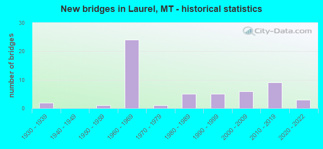
- New bridges - historical statistics
- 21930-1939
- 11950-1959
- 241960-1969
- 11970-1979
- 51980-1989
- 51990-1999
- 62000-2009
- 92010-2019
- 32020-2022
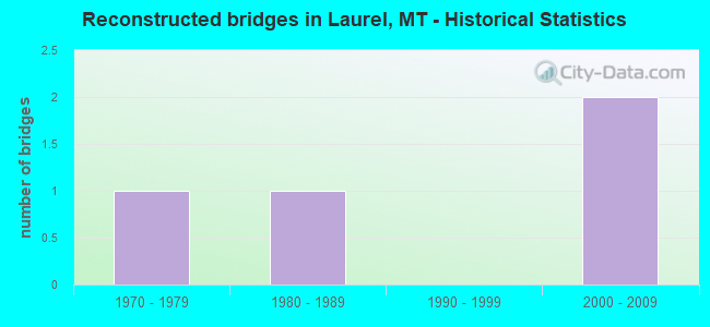
- Reconstructed bridges - Historical Statistics
- 11970-1979
- 11980-1989
- 01990-1999
- 22000-2009
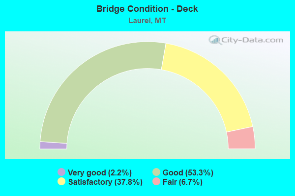
- Bridge Condition - Deck
- 2.2%Very good
- 53.3%Good
- 37.8%Satisfactory
- 6.7%Fair
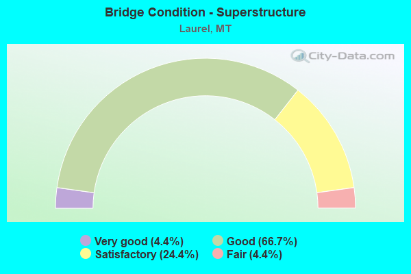
- Bridge Condition - Superstructure
- 4.4%Very good
- 66.7%Good
- 24.4%Satisfactory
- 4.4%Fair
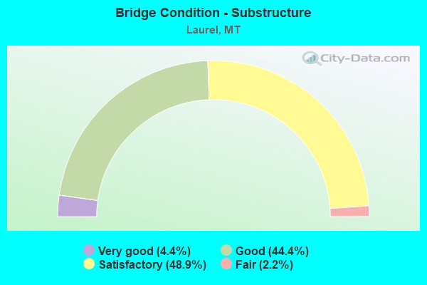
- Bridge Condition - Substructure
- 4.4%Very good
- 44.4%Good
- 48.9%Satisfactory
- 2.2%Fair
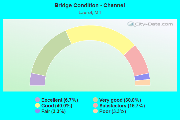
- Bridge Condition - Channel
- 6.7%Excellent
- 30.0%Very good
- 40.0%Good
- 16.7%Satisfactory
- 3.3%Fair
- 3.3%Poor
Find on map >> Show street view
Structure Number: P00004053+05141, Location: 1M S LAUREL (Lat: 45.654169, Lng: -108.759719), Route carried "on" structure: US 212, Year Built: 1997, Status: Open, Structure Length: 15.63m (51.28ft), Average Daily Traffic: 11,459 (year 2020), Truck Traffic: 5%, Average Future Daily Traffic: 12,376 (year 2040), Design Load: HL 93, Features Intersected: YELLOWSTONE RIVER
Minimum Vertical Clearance: 30+ m (98+ ft), Kilometerpoint: 87.711, Lanes on structure: 4, Base Highway Network: Yes, Owner: State Highway Agency, Approaching Roadway Width: 19.0m (62.3ft), Skew: 20 degrees, Material/Design: Steel continuous, Design/Construction: Stringer/Multi-beam, Number Of Spans In Main Unit: 5, Length of Maximum Span: 50.6m (166.0ft), Curb or Sidewalk Widths: Left: 0.0m, Right: 1.5m (4.9ft), Curb-To-Curb Width: 19.3m (63.3ft), Out-to-Out Width: 22.0m (72.2ft)
Condition: Deck: Good, Superstructure: Good, Substructure: Good, Channel: Good, Operating Rating: 38.1 metric tons, Method Used To Determine Operating Rating: Load and Resistance Factor (LRFR), Inventory Rating: 29.9 metric tons, Method Used To Determine Inventory Rating: Load and Resistance Factor (LRFR), Structural Evaluation: Better than present minimum criteria, Deck Geometry: Equal to present minimum criteria, Waterway Adequacy: Equal to present desirable criteria, Approach Roadway Alignment: Equal to present desirable criteria, Designated Inspection Frequency: Every 24 months, Underwater Inspection Frequency: Every 60 months, Inspection Date: July 2020, Underwater Inspection Date: August 2020, Deck Structure Type: Concrete Cast-file-Place, Wearing Surface/Protective System: Wearing Surface: Monolithic Concrete, Deck Protection: Epoxy Coated Reinforcing
Find on map >> Show street view
Structure Number: P00004057+07411, Location: 2M NE LAUREL (Lat: 45.682642, Lng: -108.713894), Route carried "on" structure: US 212, Year Built: 1936, Year Reconstructed: 1988, Status: Open, Structure Length: 8.20m (26.90ft), Average Daily Traffic: 5,427 (year 2020), Truck Traffic: 1%, Average Future Daily Traffic: 5,698 (year 2040), Design Load: HS 20, Features Intersected: RR
Minimum Vertical Clearance: 30+ m (98+ ft), Kilometerpoint: 94.450, Lanes on structure: 2, Base Highway Network: Yes, Owner: State Highway Agency, Approaching Roadway Width: 9.1m (29.9ft), Skew: 4 degrees, Material/Design: Steel continuous, Design/Construction: Stringer/Multi-beam, Number Of Spans In Main Unit: 3, Length of Maximum Span: 35.1m (115.2ft), Curb-To-Curb Width: 10.1m (33.1ft), Out-to-Out Width: 10.7m (35.1ft)
Condition: Deck: Satisfactory, Superstructure: Satisfactory, Substructure: Satisfactory, Operating Rating: 38.1 metric tons, Method Used To Determine Operating Rating: Load Factor (LF), Inventory Rating: 22.7 metric tons, Method Used To Determine Inventory Rating: Load Factor (LF), Structural Evaluation: Somewhat better than minimum adequacy, Deck Geometry: Meets minimum limits, Underclear: Meets minimum limits, Approach Roadway Alignment: Equal to present minimum criteria, Designated Inspection Frequency: Every 24 months, Inspection Date: April 2021, Deck Structure Type: Concrete Cast-file-Place, Wearing Surface/Protective System: Wearing Surface: Monolithic Concrete, Deck Protection: Epoxy Coated Reinforcing
Find on map >> Show street view
Structure Number: U06901000+09431, Location: LAUREL-1ST AVE (Lat: 45.683253, Lng: -108.771550), Route carried "on" structure: City street 6901, Year Built: 1968, Status: Open, Structure Length: 1.13m (3.71ft), Average Daily Traffic: 2,566 (year 2020), Truck Traffic: 14%, Average Future Daily Traffic: 2,694 (year 2040), Design Load: HL 93, Features Intersected: BIG DITCH, Facility Carried by Structure: 1ST AVE
Minimum Vertical Clearance: 30+ m (98+ ft), Kilometerpoint: 1.577, Lanes on structure: 2, Owner: County Highway Agency, Approaching Roadway Width: 12.2m (40.0ft), Material/Design: Steel, Design/Construction: Stringer/Multi-beam, Number Of Spans In Main Unit: 1, Length of Maximum Span: 10.7m (35.1ft), Curb or Sidewalk Widths: Left: 0.2m (0.7ft), Right: 0.2m (0.7ft), Curb-To-Curb Width: 12.2m (40.0ft), Out-to-Out Width: 13.0m (42.7ft)
Condition: Deck: Good, Superstructure: Good, Substructure: Satisfactory, Channel: Very good, Operating Rating: 41.7 metric tons, Method Used To Determine Operating Rating: Load and Resistance Factor (LRFR), Inventory Rating: 31.8 metric tons, Method Used To Determine Inventory Rating: Load and Resistance Factor (LRFR), Structural Evaluation: Equal to present minimum criteria, Deck Geometry: Equal to present minimum criteria, Waterway Adequacy: Superior to present desirable criteria, Approach Roadway Alignment: Equal to present desirable criteria, Designated Inspection Frequency: Every 24 months, Inspection Date: November 2020, Deck Structure Type: Concrete Cast-file-Place, Wearing Surface/Protective System: Wearing Surface: Monolithic Concrete
Find on map >> Show street view
Structure Number: U06903002+06001, Location: 2M E LAUREL (Lat: 45.679542, Lng: -108.719822), Route carried "on" structure: City street 6903, Year Built: 1984, Status: Open, Structure Length: 1.16m (3.81ft), Average Daily Traffic: 1,556 (year 2020), Truck Traffic: 3%, Average Future Daily Traffic: 1,828 (year 2040), Design Load: HS 20, Features Intersected: CANYON CREEK DITCH, Facility Carried by Structure: SHANNON RD
Minimum Vertical Clearance: 30+ m (98+ ft), Kilometerpoint: 4.493, Lanes on structure: 2, Owner: County Highway Agency, Approaching Roadway Width: 9.8m (32.2ft), Skew: 3 degrees, Material/Design: Prestressed concrete, Design/Construction: Tee Beam, Number Of Spans In Main Unit: 1, Length of Maximum Span: 10.7m (35.1ft), Curb-To-Curb Width: 9.8m (32.2ft), Out-to-Out Width: 9.8m (32.2ft)
Condition: Deck: Good, Superstructure: Good, Substructure: Good, Channel: Very good, Operating Rating: 32.7 metric tons, Method Used To Determine Operating Rating: Assigned rating based on Load Factor Design (LFD) reported in metric tons, Inventory Rating: 32.7 metric tons, Method Used To Determine Inventory Rating: Assigned rating based on Load Factor Design (LFD) reported in metric tons, Structural Evaluation: Better than present minimum criteria, Deck Geometry: Somewhat better than minimum adequacy, Waterway Adequacy: Superior to present desirable criteria, Approach Roadway Alignment: Equal to present minimum criteria, Designated Inspection Frequency: Every 24 months, Inspection Date: October 2020, Deck Structure Type: Concrete Precast Panels
Find on map >> Show street view
Structure Number: 1741, Location: LAUREL (Lat: 45.663942, Lng: -108.789969), Route carried "under" structure: ServiceCity street 6902, Year Built: 2018, Structure Length: 0. m, Average Daily Traffic: 723 (year 2020), Truck Traffic: 9%, Features Intersected: INT W LAUREL-RR, Facility Carried by Structure: I 90
Minimum Vertical Clearance: 7.13m (23.39ft), Kilometerpoint: 1.508, Lanes on structure: 2, Lanes under structure: 2, Material/Design: Steel continuous, Design/Construction: Stringer/Multi-beam, Length of Maximum Span: 66.4m (217.8ft)
Find on map >> Show street view
Structure Number: 201901742, Location: LAUREL (Lat: 45.664039, Lng: -108.789628), Route carried "under" structure: City street 6902, Year Built: 2019, Structure Length: 0. m, Average Daily Traffic: 100 (year 2022), Truck Traffic: 3%, Features Intersected: INT W LAUREL-RR, Facility Carried by Structure: I 90
Minimum Vertical Clearance: 6.40m (21.00ft), Kilometerpoint: 0.000, Lanes on structure: 2, Lanes under structure: 4, Material/Design: Steel continuous, Design/Construction: Stringer/Multi-beam, Length of Maximum Span: 51.8m (169.9ft)
Find on map >> Show street view
Structure Number: 202007026, Location: Laurel (Lat: 45.661867, Lng: -108.802517), Route carried "under" structure: Interstate 90, Year Built: 2020, Structure Length: 0. m, Average Daily Traffic: 13,605 (year 2020), Truck Traffic: 17%, Features Intersected: I-90, Facility Carried by Structure: 19th Ave W
Minimum Vertical Clearance: 5.26m (17.26ft), Kilometerpoint: 692.571, Lanes on structure: 2, Lanes under structure: 4, Material/Design: Prestressed concrete, Design/Construction: Stringer/Multi-beam, Length of Maximum Span: 36.9m (121.1ft)
Find on map >> Show street view
Structure Number: I00090431+03331, Location: 19M W LAUREL (Lat: 45.656803, Lng: -108.822536), Route carried "under" structure: Bypass State highway 56548, Year Built: 1967, Structure Length: 0. m, Average Daily Traffic: 100 (year 2022), Truck Traffic: 3%, Features Intersected: SEP WOLD ROAD, Facility Carried by Structure: I 90
Minimum Vertical Clearance: 5.18m (16.99ft), Kilometerpoint: 2.735, Lanes on structure: 2, Lanes under structure: 2, Material/Design: Prestressed concrete, Design/Construction: Stringer/Multi-beam, Length of Maximum Span: 12.8m (42.0ft)
Find on map >> Show street view
Structure Number: I00090431+03332, Location: 19M W LAUREL (Lat: 45.657042, Lng: -108.822514), Route carried "under" structure: ServiceState highway 56548, Year Built: 1967, Structure Length: 0. m, Average Daily Traffic: 100 (year 2022), Truck Traffic: 3%, Features Intersected: SEP WOLD ROAD, Facility Carried by Structure: I 90
Minimum Vertical Clearance: 4.77m (15.65ft), Kilometerpoint: 2.761, Lanes on structure: 2, Lanes under structure: 2, Material/Design: Prestressed concrete, Design/Construction: Stringer/Multi-beam, Length of Maximum Span: 12.8m (42.0ft)
Find on map >> Show street view
Structure Number: I00090434+00901, Location: LAUREL (Lat: 45.662467, Lng: -108.769667), Route carried "under" structure: US 4, Year Built: 1964, Structure Length: 0. m, Average Daily Traffic: 10,978 (year 2020), Features Intersected: INT LAUREL-P 4-RR, Facility Carried by Structure: I 90
Minimum Vertical Clearance: 7.69m (25.23ft), Kilometerpoint: 88.916, Lanes on structure: 2, Lanes under structure: 4, Material/Design: Steel, Design/Construction: Stringer/Multi-beam, Length of Maximum Span: 34.1m (111.9ft)
Find on map >> Show street view
Structure Number: I00090434+00902, Location: LAUREL (Lat: 45.662650, Lng: -108.769928), Route carried "under" structure: US 4, Year Built: 1964, Structure Length: 0. m, Average Daily Traffic: 10,978 (year 2020), Features Intersected: INT LAUREL-P 4-RR, Facility Carried by Structure: I 90
Minimum Vertical Clearance: 7.62m (25.00ft), Kilometerpoint: 88.946, Lanes on structure: 2, Lanes under structure: 4, Material/Design: Steel, Design/Construction: Stringer/Multi-beam, Length of Maximum Span: 34.1m (111.9ft)
Find on map >> Show street view
Structure Number: I00090437+04791, Location: 31M E LAUREL (Lat: 45.683011, Lng: -108.705878), Route carried "under" structure: US 4, Year Built: 1964, Structure Length: 0. m, Average Daily Traffic: 5,427 (year 2020), Truck Traffic: 1%, Features Intersected: INT MOSSMAIN ROAD-P 4, Facility Carried by Structure: I 90
Minimum Vertical Clearance: 4.62m (15.16ft), Kilometerpoint: 95.192, Lanes on structure: 2, Lanes under structure: 2, Material/Design: Prestressed concrete, Design/Construction: Stringer/Multi-beam, Length of Maximum Span: 14.3m (46.9ft)
Find on map >> Show street view
Structure Number: I00090437+04792, Location: 31M E LAUREL (Lat: 45.683231, Lng: -108.705994), Route carried "under" structure: US 4, Year Built: 1964, Structure Length: 0. m, Average Daily Traffic: 5,427 (year 2020), Truck Traffic: 1%, Features Intersected: INT MOSSMAIN ROAD-P 4, Facility Carried by Structure: I 90
Minimum Vertical Clearance: 4.60m (15.09ft), Kilometerpoint: 95.169, Lanes on structure: 2, Lanes under structure: 2, Material/Design: Prestressed concrete, Design/Construction: Stringer/Multi-beam, Length of Maximum Span: 14.3m (46.9ft)
Find on map >> Show street view
Structure Number: L56682000+01901, Location: 1M E LAUREL (Lat: 45.670597, Lng: -108.740542), Route carried "under" structure: Interstate 90, Year Built: 1964, Structure Length: 0. m, Average Daily Traffic: 22,704 (year 2020), Truck Traffic: 12%, Features Intersected: SEP I 90 013, Facility Carried by Structure: STRAUCH RD
Minimum Vertical Clearance: 5.23m (17.16ft), Kilometerpoint: 697.616, Lanes on structure: 2, Lanes under structure: 4, Material/Design: Prestressed concrete, Design/Construction: Stringer/Multi-beam, Length of Maximum Span: 21.9m (71.9ft)
Find on map >> Show street view
Structure Number: L56999000+00501, Location: LAUREL-S 8TH AVE (Lat: 45.660736, Lng: -108.781767), Route carried "under" structure: Interstate 90, Year Built: 1967, Structure Length: 0. m, Average Daily Traffic: 13,672 (year 2020), Truck Traffic: 17%, Features Intersected: SEP I 90 010, Facility Carried by Structure: S 8TH AVE
Minimum Vertical Clearance: 6.04m (19.82ft), Kilometerpoint: 694.172, Lanes on structure: 2, Lanes under structure: 4, Material/Design: Prestressed concrete, Design/Construction: Stringer/Multi-beam, Length of Maximum Span: 21.9m (71.9ft)