Bridge Statistics for Lawrenceville, Virginia (VA)
Condition, Traffic, Stress, Structural Evaluation, Project Costs
- National Bridge Inventory (NBI) Statistics
- 29Number of bridges
- 299ft / 91.3mTotal length
- $29,500,000Total costs
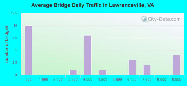
- 103,237Total average daily traffic
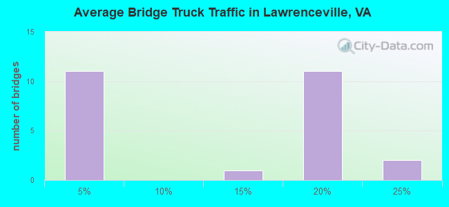
- 13,742Total average daily truck traffic
- National Bridge Inventory (NBI) Registered Bridges for Lawrenceville
- No street view available for this location
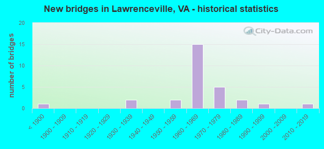
- New bridges - historical statistics
- 1Before 1900
- 21930-1939
- 21950-1959
- 151960-1969
- 51970-1979
- 21980-1989
- 11990-1999
- 12010-2019
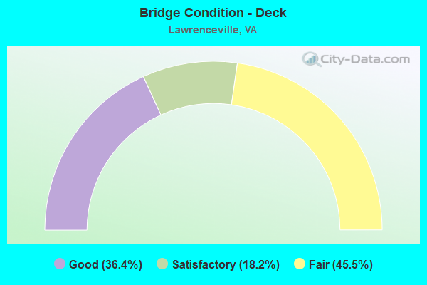
- Bridge Condition - Deck
- 36.4%Good
- 18.2%Satisfactory
- 45.5%Fair
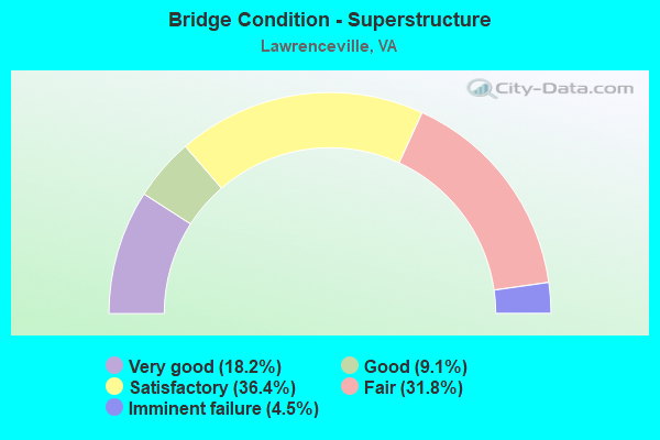
- Bridge Condition - Superstructure
- 18.2%Very good
- 9.1%Good
- 36.4%Satisfactory
- 31.8%Fair
- 4.5%Imminent failure
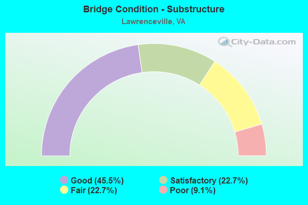
- Bridge Condition - Substructure
- 45.5%Good
- 22.7%Satisfactory
- 22.7%Fair
- 9.1%Poor
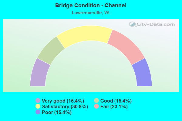
- Bridge Condition - Channel
- 15.4%Very good
- 15.4%Good
- 30.8%Satisfactory
- 23.1%Fair
- 15.4%Poor
Find on map >> Show street view
Structure Number: 3545, Location: .01DEADEND& .02TURNBUL ST (Lat: 36.747969, Lng: -77.839753), Route carried "on" structure: Other road , Year Built: 1961, Status: Open, Structure Length: 5.61m (18.41ft), Average Daily Traffic: 50 (year 1991), Truck Traffic: 2%, Average Future Daily Traffic: 70 (year 2035), Design Load: HS 20+Mod, Features Intersected: U. S. 58, Facility Carried by Structure: MEADOW LANE
Minimum Vertical Clearance: 30+ m (98+ ft), Kilometerpoint: 0.016, Lanes on structure: 2, Lanes under structure: 4, Owner: State Highway Agency, Approaching Roadway Width: 7.3m (24.0ft), Skew: 1 degrees, Material/Design: Steel, Design/Construction: Stringer/Multi-beam, Number Of Spans In Main Unit: 4, Length of Maximum Span: 17.4m (57.1ft), Curb or Sidewalk Widths: Left: 0.8m (2.6ft), Right: 0.8m (2.6ft), Curb-To-Curb Width: 7.3m (24.0ft), Out-to-Out Width: 8.8m (28.9ft)
Condition: Deck: Good, Superstructure: Good, Substructure: Good, Operating Rating: 49.0 metric tons, Method Used To Determine Operating Rating: Load and Resistance Factor (LRFR), Inventory Rating: 37.7 metric tons, Method Used To Determine Inventory Rating: Load and Resistance Factor (LRFR), Structural Evaluation: Better than present minimum criteria, Deck Geometry: Equal to present minimum criteria, Underclear: Meets minimum limits, Approach Roadway Alignment: Equal to present desirable criteria, Length Of Structure Improvement: 7.01m (23.00ft), Designated Inspection Frequency: Every 24 months, Inspection Date: August 2021, Bridge Improvement Cost: $2,760,000, Roadway Improvement Cost: $1,000,000, Total Project Cost: $3,800,000, Deck Structure Type: Concrete Cast-file-Place
Find on map >> Show street view
Structure Number: 3568, Location: .1 FR 58 & .4 SCL LARVL (Lat: 36.750550, Lng: -77.855214), Route carried "on" structure: State highway 46, Year Built: 1988, Status: Open, Structure Length: 2.50m (8.20ft), Average Daily Traffic: 5,634 (year 2020), Truck Traffic: 3%, Average Future Daily Traffic: 6,197 (year 2040), Design Load: HS 20+Mod, Features Intersected: GREAT CREEK, Facility Carried by Structure: CHRISTINNA HIGHWAY
Minimum Vertical Clearance: 30+ m (98+ ft), Kilometerpoint: 26.758, Lanes on structure: 2, Base Highway Network: Yes, Owner: State Highway Agency, Approaching Roadway Width: 13.4m (44.0ft), Material/Design: Steel continuous, Design/Construction: Stringer/Multi-beam, Number Of Spans In Main Unit: 1, Length of Maximum Span: 24.4m (80.1ft), Curb or Sidewalk Widths: Left: 0.5m (1.6ft), Right: 0.5m (1.6ft), Curb-To-Curb Width: 13.0m (42.7ft), Out-to-Out Width: 14.0m (45.9ft)
Condition: Deck: Good, Superstructure: Very good, Substructure: Good, Channel: Very good, Operating Rating: 60.8 metric tons, Method Used To Determine Operating Rating: Load and Resistance Factor (LRFR), Inventory Rating: 47.2 metric tons, Method Used To Determine Inventory Rating: Load and Resistance Factor (LRFR), Structural Evaluation: Better than present minimum criteria, Deck Geometry: Somewhat better than minimum adequacy, Waterway Adequacy: Equal to present minimum criteria, Approach Roadway Alignment: Equal to present desirable criteria, Length Of Structure Improvement: 3.14m (10.30ft), Designated Inspection Frequency: Every 24 months, Inspection Date: July 2020, Bridge Improvement Cost: $1,236,000, Roadway Improvement Cost: $618,000, Total Project Cost: $1,855,000 ( Estimate for 2016), Deck Structure Type: Concrete Cast-file-Place, Wearing Surface/Protective System: Deck Protection: Epoxy Coated Reinforcing
Find on map >> Show street view
Structure Number: 357, Location: .1 FR 1005 & .04 TO 1016 (Lat: 36.756292, Lng: -77.849400), Route carried "on" structure: State highway 46, Year Built: 1956, Status: Open, Structure Length: 3.43m (11.25ft), Average Daily Traffic: 5,634 (year 2020), Truck Traffic: 2%, Average Future Daily Traffic: 6,197 (year 2040), Design Load: H 20, Features Intersected: NS RAILWAY (ABANDONED), Facility Carried by Structure: HICKS STREET
Minimum Vertical Clearance: 30+ m (98+ ft), Kilometerpoint: 1.014, Lanes on structure: 2, Base Highway Network: Yes, Owner: State Highway Agency, Approaching Roadway Width: 8.5m (27.9ft), Skew: 2 degrees, Material/Design: Concrete, Design/Construction: Slab, Number Of Spans In Main Unit: 1, Number Of Approach Spans: 2, Length of Maximum Span: 12.6m (41.3ft), Curb or Sidewalk Widths: Left: 1.8m (5.9ft), Right: 1.8m (5.9ft), Curb-To-Curb Width: 8.5m (27.9ft), Out-to-Out Width: 9.0m (29.5ft)
Condition: Deck: Fair, Superstructure: Fair, Substructure: Poor, Operating Rating: 45.4 metric tons, Method Used To Determine Operating Rating: Load and Resistance Factor (LRFR), Inventory Rating: 35.4 metric tons, Method Used To Determine Inventory Rating: Load and Resistance Factor (LRFR), Structural Evaluation: Meets minimum limits, Deck Geometry: High priority of replacement, Approach Roadway Alignment: Equal to present minimum criteria, Length Of Structure Improvement: 3.41m (11.19ft), Designated Inspection Frequency: Every 24 months, Inspection Date: November 2021, Bridge Improvement Cost: $510,000, Roadway Improvement Cost: $60,000, Total Project Cost: $781,000 ( Estimate for 2015), Deck Structure Type: Concrete Cast-file-Place, Wearing Surface/Protective System: Wearing Surface: Bituminous
Find on map >> Show street view
Structure Number: 3572, Location: .16 SCL LAW. & .02 TO 58B (Lat: 36.748153, Lng: -77.855097), Route carried "on" structure: State highway 46, Year Built: 1962, Status: Open, Structure Length: 5.93m (19.46ft), Average Daily Traffic: 5,634 (year 2020), Truck Traffic: 11%, Average Future Daily Traffic: 6,197 (year 2040), Design Load: H 20, Features Intersected: U.S. 58 BYPASS
Minimum Vertical Clearance: 30+ m (98+ ft), Kilometerpoint: 26.474, Lanes on structure: 2, Lanes under structure: 4, Base Highway Network: Yes, Owner: State Highway Agency, Approaching Roadway Width: 8.5m (27.9ft), Skew: 1 degrees, Material/Design: Steel, Design/Construction: Stringer/Multi-beam, Number Of Spans In Main Unit: 4, Length of Maximum Span: 17.3m (56.8ft), Curb or Sidewalk Widths: Left: 0.5m (1.6ft), Right: 0.5m (1.6ft), Curb-To-Curb Width: 8.5m (27.9ft), Out-to-Out Width: 10.1m (33.1ft)
Condition: Deck: Fair, Superstructure: Fair, Substructure: Fair, Operating Rating: 43.4 metric tons, Method Used To Determine Operating Rating: Load and Resistance Factor (LRFR), Inventory Rating: 33.5 metric tons, Method Used To Determine Inventory Rating: Load and Resistance Factor (LRFR), Structural Evaluation: Somewhat better than minimum adequacy, Deck Geometry: High priority of replacement, Underclear: Somewhat better than minimum adequacy, Approach Roadway Alignment: Equal to present desirable criteria, Length Of Structure Improvement: 5.94m (19.49ft), Designated Inspection Frequency: Every 24 months, Inspection Date: October 2021, Bridge Improvement Cost: $564,000, Roadway Improvement Cost: $50,000, Total Project Cost: $629,000, Deck Structure Type: Concrete Cast-file-Place, Wearing Surface/Protective System: Wearing Surface: Bituminous
Find on map >> Show street view
Structure Number: 3585, Location: 0.59 FR 656 & 0.91 TO 681 (Lat: 36.740603, Lng: -77.893086), Route carried "on" structure: US 58, Year Built: 1931, Status: Open, Structure Length: 0.99m (3.25ft), Average Daily Traffic: 3,967 (year 2020), Truck Traffic: 19%, Average Future Daily Traffic: 5,555 (year 2040), Design Load: HS 20+Mod, Features Intersected: TOTARO CREEK
Minimum Vertical Clearance: 30+ m (98+ ft), Kilometerpoint: 623.413, Lanes on structure: 2, Base Highway Network: Yes, Owner: State Highway Agency, Approaching Roadway Width: 8.5m (27.9ft), Material/Design: Concrete, Design/Construction: Tee Beam, Number Of Spans In Main Unit: 1, Length of Maximum Span: 9.5m (31.2ft), Curb or Sidewalk Widths: Left: 0.5m (1.6ft), Right: 0.5m (1.6ft), Curb-To-Curb Width: 7.0m (23.0ft), Out-to-Out Width: 7.8m (25.6ft)
Condition: Deck: Fair, Superstructure: Fair, Substructure: Fair, Channel: Poor, Operating Rating: 40.0 metric tons, Method Used To Determine Operating Rating: Load and Resistance Factor (LRFR), Inventory Rating: 30.8 metric tons, Method Used To Determine Inventory Rating: Load and Resistance Factor (LRFR), Structural Evaluation: Somewhat better than minimum adequacy, Deck Geometry: High priority of replacement, Waterway Adequacy: Somewhat better than minimum adequacy, Approach Roadway Alignment: Equal to present desirable criteria, Length Of Structure Improvement: 1.22m (4.00ft), Designated Inspection Frequency: Every 24 months, Inspection Date: Febuary 2021, Bridge Improvement Cost: $107,000, Roadway Improvement Cost: $30,000, Total Project Cost: $247,000 ( Estimate for 2017), Deck Structure Type: Concrete Cast-file-Place, Wearing Surface/Protective System: Wearing Surface: Bituminous
Find on map >> Show street view
Structure Number: 3588, Location: 1.4 FR 46 & 1.4 TO 58B (Lat: 36.748883, Lng: -77.837742), Route carried "on" structure: Bypass US 58, Year Built: 1962, Status: Open, Structure Length: 3.43m (11.25ft), Average Daily Traffic: 3,707 (year 2020), Truck Traffic: 19%, Average Future Daily Traffic: 5,191 (year 2040), Design Load: HS 20, Features Intersected: ROSE CREEK
Minimum Vertical Clearance: 30+ m (98+ ft), Kilometerpoint: 628.603, Lanes on structure: 2, Base Highway Network: Yes, Owner: State Highway Agency, Approaching Roadway Width: 9.1m (29.9ft), Material/Design: Concrete, Design/Construction: Tee Beam, Number Of Spans In Main Unit: 3, Length of Maximum Span: 11.4m (37.4ft), Curb or Sidewalk Widths: Left: 0.5m (1.6ft), Right: 0.5m (1.6ft), Curb-To-Curb Width: 9.1m (29.9ft), Out-to-Out Width: 10.7m (35.1ft)
Condition: Deck: Fair, Superstructure: Satisfactory, Substructure: Satisfactory, Channel: Fair, Operating Rating: 63.5 metric tons, Method Used To Determine Operating Rating: Load and Resistance Factor (LRFR), Inventory Rating: 49.0 metric tons, Method Used To Determine Inventory Rating: Load and Resistance Factor (LRFR), Structural Evaluation: Equal to present minimum criteria, Deck Geometry: Meets minimum limits, Waterway Adequacy: Somewhat better than minimum adequacy, Approach Roadway Alignment: Equal to present desirable criteria, Length Of Structure Improvement: 4.39m (14.40ft), Designated Inspection Frequency: Every 24 months, Underwater Inspection Frequency: Every 60 months, Inspection Date: March 2021, Underwater Inspection Date: November 2021, Bridge Improvement Cost: $1,728,000, Roadway Improvement Cost: $864,000, Total Project Cost: $2,600,000, Deck Structure Type: Concrete Cast-file-Place, Wearing Surface/Protective System: Wearing Surface: Bituminous
Find on map >> Show street view
Structure Number: 3589, Location: 2.44 FR 46 & 1.54 TO 750 (Lat: 36.766494, Lng: -77.824653), Route carried "on" structure: Bypass US 58, Year Built: 1961, Status: Open, Structure Length: 4.42m (14.50ft), Average Daily Traffic: 3,707 (year 2020), Truck Traffic: 19%, Average Future Daily Traffic: 5,191 (year 2040), Design Load: HS 20+Mod, Features Intersected: 58 BUSINESS
Minimum Vertical Clearance: 30+ m (98+ ft), Kilometerpoint: 630.862, Lanes on structure: 2, Lanes under structure: 2, Base Highway Network: Yes, Owner: State Highway Agency, Approaching Roadway Width: 9.1m (29.9ft), Skew: 3 degrees, Material/Design: Steel, Design/Construction: Stringer/Multi-beam, Number Of Spans In Main Unit: 3, Length of Maximum Span: 16.2m (53.1ft), Curb or Sidewalk Widths: Left: 0.5m (1.6ft), Right: 0.5m (1.6ft), Curb-To-Curb Width: 9.1m (29.9ft), Out-to-Out Width: 10.7m (35.1ft)
Condition: Deck: Fair, Superstructure: Fair, Substructure: Fair, Operating Rating: 54.7 metric tons, Method Used To Determine Operating Rating: Load and Resistance Factor (LRFR), Inventory Rating: 42.2 metric tons, Method Used To Determine Inventory Rating: Load and Resistance Factor (LRFR), Structural Evaluation: Somewhat better than minimum adequacy, Deck Geometry: Meets minimum limits, Underclear: Meets minimum limits, Approach Roadway Alignment: Equal to present desirable criteria, Designated Inspection Frequency: Every 24 months, Inspection Date: March 2021, Deck Structure Type: Concrete Cast-file-Place, Wearing Surface/Protective System: Wearing Surface: Bituminous, Membrane: Preformed Fabric
Find on map >> Show street view
Structure Number: 3591, Location: .26 FR 46 & 2.17 TO 58B (Lat: 36.748094, Lng: -77.850714), Route carried "on" structure: Bypass US 58, Year Built: 1962, Status: Open, Structure Length: 5.82m (19.09ft), Average Daily Traffic: 3,707 (year 2020), Truck Traffic: 19%, Average Future Daily Traffic: 5,191 (year 2040), Design Load: HS 20, Features Intersected: GREAT CREEK
Minimum Vertical Clearance: 30+ m (98+ ft), Kilometerpoint: 627.372, Lanes on structure: 2, Base Highway Network: Yes, Owner: State Highway Agency, Approaching Roadway Width: 9.1m (29.9ft), Skew: 3 degrees, Material/Design: Steel, Design/Construction: Stringer/Multi-beam, Number Of Spans In Main Unit: 3, Length of Maximum Span: 19.5m (64.0ft), Curb or Sidewalk Widths: Left: 0.5m (1.6ft), Right: 0.5m (1.6ft), Curb-To-Curb Width: 9.1m (29.9ft), Out-to-Out Width: 10.1m (33.1ft)
Condition: Deck: Fair, Superstructure: Satisfactory, Substructure: Satisfactory, Channel: Satisfactory, Operating Rating: 75.3 metric tons, Method Used To Determine Operating Rating: Load and Resistance Factor (LRFR), Inventory Rating: 57.9 metric tons, Method Used To Determine Inventory Rating: Load and Resistance Factor (LRFR), Structural Evaluation: Equal to present minimum criteria, Deck Geometry: Meets minimum limits, Waterway Adequacy: Equal to present minimum criteria, Approach Roadway Alignment: Equal to present desirable criteria, Length Of Structure Improvement: 6.86m (22.51ft), Designated Inspection Frequency: Every 24 months, Inspection Date: January 2021, Bridge Improvement Cost: $150,000, Roadway Improvement Cost: $15,000, Total Project Cost: $170,000, Deck Structure Type: Concrete Cast-file-Place, Wearing Surface/Protective System: Wearing Surface: Bituminous
Find on map >> Show street view
Structure Number: 3592, Location: 2.38 FR 46 & .05 TO 58B (Lat: 36.765869, Lng: -77.825106), Route carried "on" structure: Bypass US 58, Year Built: 1962, Status: Open, Structure Length: 5.50m (18.04ft), Average Daily Traffic: 3,707 (year 2020), Truck Traffic: 20%, Average Future Daily Traffic: 5,191 (year 2040), Design Load: HS 20+Mod, Features Intersected: NS RAILWAY (ABANDONED)
Minimum Vertical Clearance: 30+ m (98+ ft), Kilometerpoint: 630.786, Lanes on structure: 2, Base Highway Network: Yes, Owner: State Highway Agency, Approaching Roadway Width: 9.1m (29.9ft), Skew: 4 degrees, Material/Design: Steel, Design/Construction: Stringer/Multi-beam, Number Of Spans In Main Unit: 3, Length of Maximum Span: 19.1m (62.7ft), Curb or Sidewalk Widths: Left: 0.5m (1.6ft), Right: 0.5m (1.6ft), Curb-To-Curb Width: 9.1m (29.9ft), Out-to-Out Width: 10.1m (33.1ft)
Condition: Deck: Fair, Superstructure: Fair, Substructure: Satisfactory, Operating Rating: 87.9 metric tons, Method Used To Determine Operating Rating: Load and Resistance Factor (LRFR), Inventory Rating: 67.6 metric tons, Method Used To Determine Inventory Rating: Load and Resistance Factor (LRFR), Structural Evaluation: Somewhat better than minimum adequacy, Deck Geometry: Meets minimum limits, Approach Roadway Alignment: Equal to present desirable criteria, Length Of Structure Improvement: 5.52m (18.11ft), Designated Inspection Frequency: Every 24 months, Inspection Date: Febuary 2021, Bridge Improvement Cost: $350,000, Roadway Improvement Cost: $20,000, Total Project Cost: $375,000, Deck Structure Type: Concrete Cast-file-Place, Wearing Surface/Protective System: Wearing Surface: Bituminous
Find on map >> Show street view
Structure Number: 3593, Location: 2.25 TO 46RMP & 1.5 - 750 (Lat: 36.766492, Lng: -77.824908), Route carried "on" structure: Bypass US 58, Year Built: 1974, Status: Open, Structure Length: 4.21m (13.81ft), Average Daily Traffic: 3,707 (year 2020), Truck Traffic: 19%, Average Future Daily Traffic: 5,191 (year 2040), Design Load: HS 20+Mod, Features Intersected: U.S. 58 BUSINESS
Minimum Vertical Clearance: 30+ m (98+ ft), Kilometerpoint: 630.863, Lanes on structure: 2, Lanes under structure: 2, Base Highway Network: Yes, Owner: State Highway Agency, Approaching Roadway Width: 11.6m (38.1ft), Skew: 3 degrees, Material/Design: Steel, Design/Construction: Stringer/Multi-beam, Number Of Spans In Main Unit: 3, Length of Maximum Span: 16.2m (53.1ft), Curb-To-Curb Width: 11.6m (38.1ft), Out-to-Out Width: 12.8m (42.0ft)
Condition: Deck: Satisfactory, Superstructure: Fair, Substructure: Fair, Operating Rating: 67.1 metric tons, Method Used To Determine Operating Rating: Load and Resistance Factor (LRFR), Inventory Rating: 51.7 metric tons, Method Used To Determine Inventory Rating: Load and Resistance Factor (LRFR), Structural Evaluation: Somewhat better than minimum adequacy, Deck Geometry: Better than present minimum criteria, Approach Roadway Alignment: Equal to present desirable criteria, Designated Inspection Frequency: Every 24 months, Inspection Date: March 2021, Deck Structure Type: Concrete Cast-file-Place
Find on map >> Show street view
Structure Number: 3596, Location: .85 FR 46R & 1.4 TO 58B (Lat: 36.748967, Lng: -77.837922), Route carried "on" structure: Bypass US 58, Year Built: 1974, Status: Open, Structure Length: 3.47m (11.38ft), Average Daily Traffic: 3,707 (year 2020), Truck Traffic: 19%, Average Future Daily Traffic: 5,191 (year 2040), Design Load: HS 20+Mod, Features Intersected: ROSES CREEK
Minimum Vertical Clearance: 30+ m (98+ ft), Kilometerpoint: 628.603, Lanes on structure: 2, Base Highway Network: Yes, Owner: State Highway Agency, Approaching Roadway Width: 11.6m (38.1ft), Material/Design: Concrete continuous, Design/Construction: Slab, Number Of Spans In Main Unit: 3, Length of Maximum Span: 11.6m (38.1ft), Curb-To-Curb Width: 11.6m (38.1ft), Out-to-Out Width: 12.8m (42.0ft)
Condition: Deck: Satisfactory, Superstructure: Satisfactory, Substructure: Good, Channel: Good, Operating Rating: 51.7 metric tons, Method Used To Determine Operating Rating: Load and Resistance Factor (LRFR), Inventory Rating: 39.9 metric tons, Method Used To Determine Inventory Rating: Load and Resistance Factor (LRFR), Structural Evaluation: Equal to present minimum criteria, Deck Geometry: Better than present minimum criteria, Waterway Adequacy: Equal to present minimum criteria, Approach Roadway Alignment: Equal to present desirable criteria, Length Of Structure Improvement: 3.47m (11.38ft), Designated Inspection Frequency: Every 24 months, Inspection Date: March 2021, Bridge Improvement Cost: $330,000, Roadway Improvement Cost: $90,000, Total Project Cost: $430,000, Deck Structure Type: Concrete Cast-file-Place
Find on map >> Show street view
Structure Number: 3603, Location: .2 fr 46 & .15 ECL LAWRV (Lat: 36.761497, Lng: -77.845419), Route carried "on" structure: Business US 58, Year Built: 1934, Status: Open, Structure Length: 2.51m (8.23ft), Average Daily Traffic: 4,511 (year 2020), Truck Traffic: 3%, Average Future Daily Traffic: 4,962 (year 2040), Design Load: HS 20+Mod, Features Intersected: ROSE CK @ LAWRENCEVILLE
Minimum Vertical Clearance: 30+ m (98+ ft), Kilometerpoint: 644.702, Lanes on structure: 2, Owner: State Highway Agency, Approaching Roadway Width: 11.0m (36.1ft), Skew: 3 degrees, Material/Design: Concrete, Design/Construction: Tee Beam, Number Of Spans In Main Unit: 3, Length of Maximum Span: 8.4m (27.6ft), Curb or Sidewalk Widths: Left: 0.6m (2.0ft), Right: 1.8m (5.9ft), Curb-To-Curb Width: 10.1m (33.1ft), Out-to-Out Width: 12.8m (42.0ft)
Condition: Deck: Fair, Superstructure: Satisfactory, Substructure: Fair, Channel: Fair, Operating Rating: 58.1 metric tons, Method Used To Determine Operating Rating: Load and Resistance Factor (LRFR), Inventory Rating: 44.5 metric tons, Method Used To Determine Inventory Rating: Load and Resistance Factor (LRFR), Structural Evaluation: Somewhat better than minimum adequacy, Deck Geometry: Meets minimum limits, Waterway Adequacy: Somewhat better than minimum adequacy, Approach Roadway Alignment: Equal to present minimum criteria, Length Of Structure Improvement: 3.17m (10.40ft), Designated Inspection Frequency: Every 24 months, Inspection Date: March 2020, Bridge Improvement Cost: $1,245,000, Roadway Improvement Cost: $623,000, Total Project Cost: $1,889,000 ( Estimate for 2014), Deck Structure Type: Concrete Cast-file-Place
Find on map >> Show street view
Structure Number: 3606, Location: 0.59 FR 656 & 0.91 TO 681 (Lat: 36.740836, Lng: -77.893150), Route carried "on" structure: US 58, Year Built: 1964, Status: Open, Structure Length: 0.94m (3.08ft), Average Daily Traffic: 3,967 (year 2020), Truck Traffic: 19%, Average Future Daily Traffic: 5,555 (year 2040), Design Load: HS 20, Features Intersected: TOTARO CREEK
Minimum Vertical Clearance: 30+ m (98+ ft), Kilometerpoint: 623.413, Lanes on structure: 2, Base Highway Network: Yes, Owner: State Highway Agency, Approaching Roadway Width: 9.1m (29.9ft), Material/Design: Concrete, Design/Construction: Culvert, Number Of Spans In Main Unit: 4, Length of Maximum Span: 2.1m (6.9ft)
Condition: Channel: Satisfactory, Culverts: Satisfactory, Operating Rating: 54.4 metric tons, Method Used To Determine Operating Rating: Field evaluation and documented engineering judgment, Inventory Rating: 32.7 metric tons, Method Used To Determine Inventory Rating: Field evaluation and documented engineering judgment, Structural Evaluation: Equal to present minimum criteria, Waterway Adequacy: Somewhat better than minimum adequacy, Approach Roadway Alignment: Equal to present desirable criteria, Length Of Structure Improvement: 1.16m (3.81ft), Designated Inspection Frequency: Every 17 months, Inspection Date: Febuary 2021, Bridge Improvement Cost: $250,000, Roadway Improvement Cost: $125,000, Total Project Cost: $378,000 ( Estimate for 2017)
Find on map >> Show street view
Structure Number: 3744, Location: 1.48 FR 674 & .3 TO 715 (Lat: 36.709056, Lng: -77.828281), Route carried "on" structure: County highway 673, Year Built: 1990, Status: Open, Structure Length: 1.91m (6.27ft), Average Daily Traffic: 440 (year 2020), Truck Traffic: 3%, Average Future Daily Traffic: 484 (year 2040), Design Load: HS 20+Mod, Features Intersected: ALLEN CREEK, Facility Carried by Structure: REVIS GIN ROAD
Minimum Vertical Clearance: 30+ m (98+ ft), Kilometerpoint: 5.775, Lanes on structure: 2, Owner: State Highway Agency, Approaching Roadway Width: 9.1m (29.9ft), Material/Design: Steel, Design/Construction: Stringer/Multi-beam, Number Of Spans In Main Unit: 1, Length of Maximum Span: 18.3m (60.0ft), Curb or Sidewalk Widths: Left: 0.5m (1.6ft), Right: 0.5m (1.6ft), Curb-To-Curb Width: 8.5m (27.9ft), Out-to-Out Width: 9.6m (31.5ft)
Condition: Deck: Good, Superstructure: Very good, Substructure: Good, Channel: Satisfactory, Operating Rating: 89.8 metric tons, Method Used To Determine Operating Rating: Load and Resistance Factor (LRFR), Inventory Rating: 75.2 metric tons, Method Used To Determine Inventory Rating: Load and Resistance Factor (LRFR), Structural Evaluation: Better than present minimum criteria, Deck Geometry: Somewhat better than minimum adequacy, Waterway Adequacy: Better than present minimum criteria, Approach Roadway Alignment: Equal to present desirable criteria, Length Of Structure Improvement: 2.41m (7.91ft), Designated Inspection Frequency: Every 24 months, Inspection Date: July 2020, Bridge Improvement Cost: $948,000, Roadway Improvement Cost: $474,000, Total Project Cost: $1,435,000 ( Estimate for 2014), Deck Structure Type: Concrete Cast-file-Place, Wearing Surface/Protective System: Deck Protection: Epoxy Coated Reinforcing
Find on map >> Show street view
Structure Number: 3747, Location: 0.2 ECL LAWRE 0.5 TO 677 (Lat: 36.757914, Lng: -77.840717), Route carried "on" structure: County highway 678, Year Built: 1976, Status: Open, Structure Length: 3.33m (10.93ft), Average Daily Traffic: 354 (year 2020), Truck Traffic: 3%, Average Future Daily Traffic: 389 (year 2040), Design Load: HS 20+Mod, Features Intersected: ROSE CREEK, Facility Carried by Structure: ROSE DRIVE
Minimum Vertical Clearance: 30+ m (98+ ft), Kilometerpoint: 0.724, Lanes on structure: 2, Owner: State Highway Agency, Approaching Roadway Width: 8.5m (27.9ft), Skew: 2 degrees, Material/Design: Steel, Design/Construction: Stringer/Multi-beam, Number Of Spans In Main Unit: 2, Length of Maximum Span: 16.2m (53.1ft), Curb or Sidewalk Widths: Left: 0.6m (2.0ft), Right: 0.6m (2.0ft), Curb-To-Curb Width: 7.9m (25.9ft), Out-to-Out Width: 9.1m (29.9ft)
Condition: Deck: Good, Superstructure: Good, Substructure: Good, Channel: Fair, Operating Rating: 61.8 metric tons, Method Used To Determine Operating Rating: Load and Resistance Factor (LRFR), Inventory Rating: 47.6 metric tons, Method Used To Determine Inventory Rating: Load and Resistance Factor (LRFR), Structural Evaluation: Better than present minimum criteria, Deck Geometry: Somewhat better than minimum adequacy, Waterway Adequacy: Equal to present minimum criteria, Approach Roadway Alignment: Equal to present minimum criteria, Length Of Structure Improvement: 3.20m (10.50ft), Designated Inspection Frequency: Every 24 months, Inspection Date: January 2022, Bridge Improvement Cost: $1,320,000, Roadway Improvement Cost: $660,000, Total Project Cost: $2,210,000 ( Estimate for 2016), Deck Structure Type: Concrete Cast-file-Place
Find on map >> Show street view
Structure Number: 3748, Location: .02 FR 677 & .02 TO 752E (Lat: 36.757747, Lng: -77.831597), Route carried "on" structure: County highway 678, Year Built: 1962, Status: Open, Structure Length: 5.52m (18.11ft), Average Daily Traffic: 354 (year 2020), Average Future Daily Traffic: 389 (year 2040), Design Load: HS 20+Mod, Features Intersected: U.S. 58, Facility Carried by Structure: ROSE ROAD
Minimum Vertical Clearance: 30+ m (98+ ft), Kilometerpoint: 1.561, Lanes on structure: 2, Lanes under structure: 4, Owner: State Highway Agency, Approaching Roadway Width: 7.3m (24.0ft), Material/Design: Steel, Design/Construction: Stringer/Multi-beam, Number Of Spans In Main Unit: 4, Length of Maximum Span: 16.3m (53.5ft), Curb or Sidewalk Widths: Left: 0.8m (2.6ft), Right: 0.8m (2.6ft), Curb-To-Curb Width: 7.3m (24.0ft), Out-to-Out Width: 8.8m (28.9ft)
Condition: Deck: Satisfactory, Superstructure: Satisfactory, Substructure: Good, Operating Rating: 48.1 metric tons, Method Used To Determine Operating Rating: Load and Resistance Factor (LRFR), Inventory Rating: 37.1 metric tons, Method Used To Determine Inventory Rating: Load and Resistance Factor (LRFR), Structural Evaluation: Equal to present minimum criteria, Deck Geometry: Somewhat better than minimum adequacy, Underclear: Equal to present minimum criteria, Approach Roadway Alignment: Equal to present minimum criteria, Length Of Structure Improvement: 5.58m (18.31ft), Designated Inspection Frequency: Every 24 months, Inspection Date: May 2020, Bridge Improvement Cost: $622,000, Roadway Improvement Cost: $100,000, Total Project Cost: $832,000 ( Estimate for 2016), Deck Structure Type: Concrete Cast-file-Place
Find on map >> Show street view
Structure Number: 3751, Location: 2.4 FR 58 & .2 TO T-1205 (Lat: 36.766825, Lng: -77.906531), Route carried "on" structure: County highway 681, Year Built: 1984, Status: Open, Structure Length: 4.34m (14.24ft), Average Daily Traffic: 507 (year 2013), Average Future Daily Traffic: 652 (year 2040), Design Load: HS 20+Mod, Features Intersected: TOBACCO HERITAGE TRAIL, Facility Carried by Structure: PLEASANT GROVE RD
Minimum Vertical Clearance: 30+ m (98+ ft), Kilometerpoint: 3.862, Lanes on structure: 2, Owner: State Highway Agency, Approaching Roadway Width: 9.1m (29.9ft), Material/Design: Steel, Design/Construction: Stringer/Multi-beam, Number Of Spans In Main Unit: 3, Length of Maximum Span: 15.2m (49.9ft), Curb or Sidewalk Widths: Left: 0.5m (1.6ft), Right: 0.5m (1.6ft), Curb-To-Curb Width: 7.5m (24.6ft), Out-to-Out Width: 8.5m (27.9ft)
Condition: Deck: Good, Superstructure: Very good, Substructure: Good, Operating Rating: 70.6 metric tons, Method Used To Determine Operating Rating: Load and Resistance Factor (LRFR), Inventory Rating: 54.4 metric tons, Method Used To Determine Inventory Rating: Load and Resistance Factor (LRFR), Structural Evaluation: Better than present minimum criteria, Deck Geometry: Meets minimum limits, Approach Roadway Alignment: Equal to present desirable criteria, Length Of Structure Improvement: 4.36m (14.30ft), Designated Inspection Frequency: Every 24 months, Inspection Date: November 2020, Bridge Improvement Cost: $1,716,000, Roadway Improvement Cost: $858,000, Total Project Cost: $2,620,000 ( Estimate for 2016), Deck Structure Type: Concrete Cast-file-Place, Wearing Surface/Protective System: Deck Protection: Epoxy Coated Reinforcing
Find on map >> Show street view
Structure Number: 3752, Location: 4.7 FR 623 & 0.5 TO 46 (Lat: 36.717425, Lng: -77.857825), Route carried "on" structure: County highway 686, Year Built: 1975, Status: Open, Structure Length: 0.97m (3.18ft), Average Daily Traffic: 25 (year 2013), Average Future Daily Traffic: 28 (year 2040), Design Load: HS 20+Mod, Features Intersected: HAYES CREEK, Facility Carried by Structure: FORT HILL ROAD
Minimum Vertical Clearance: 30+ m (98+ ft), Kilometerpoint: 7.562, Lanes on structure: 2, Base Highway Network: Yes, Owner: State Highway Agency, Approaching Roadway Width: 9.1m (29.9ft), Material/Design: Steel, Design/Construction: Stringer/Multi-beam, Number Of Spans In Main Unit: 1, Length of Maximum Span: 8.8m (28.9ft), Curb or Sidewalk Widths: Left: 0.2m (0.7ft), Right: 0.2m (0.7ft), Curb-To-Curb Width: 7.0m (23.0ft), Out-to-Out Width: 7.3m (24.0ft)
Condition: Deck: Good, Superstructure: Satisfactory, Substructure: Satisfactory, Channel: Very good, Operating Rating: 44.7 metric tons, Method Used To Determine Operating Rating: Load and Resistance Factor (LRFR), Inventory Rating: 34.5 metric tons, Method Used To Determine Inventory Rating: Load and Resistance Factor (LRFR), Structural Evaluation: Equal to present minimum criteria, Deck Geometry: Somewhat better than minimum adequacy, Waterway Adequacy: Better than present minimum criteria, Approach Roadway Alignment: Equal to present minimum criteria, Length Of Structure Improvement: 1.07m (3.51ft), Designated Inspection Frequency: Every 24 months, Inspection Date: April 2021, Bridge Improvement Cost: $280,000, Roadway Improvement Cost: $140,000, Total Project Cost: $430,000 ( Estimate for 2017), Deck Structure Type: Wood or Timber, Wearing Surface/Protective System: Wearing Surface: Bituminous
Find on map >> Show street view
Structure Number: 3763, Location: .7 FR 715 & .5 toSCL LAWR (Lat: 36.745864, Lng: -77.847517), Route carried "on" structure: County highway 713, Year Built: 1962, Status: Posted for load, Structure Length: 1.25m (4.10ft), Average Daily Traffic: 211 (year 2020), Truck Traffic: 2%, Average Future Daily Traffic: 232 (year 2040), Features Intersected: GREAT CREEK, Facility Carried by Structure: OGBURN ROAD
Minimum Vertical Clearance: 30+ m (98+ ft), Kilometerpoint: 1.115, Lanes on structure: 2, Owner: State Highway Agency, Approaching Roadway Width: 7.0m (23.0ft), Material/Design: Steel, Design/Construction: Stringer/Multi-beam, Number Of Spans In Main Unit: 1, Length of Maximum Span: 12.1m (39.7ft), Curb or Sidewalk Widths: Left: 0.2m (0.7ft), Right: 0.2m (0.7ft), Curb-To-Curb Width: 6.4m (21.0ft), Out-to-Out Width: 6.7m (22.0ft)
Condition: Deck: Fair, Superstructure: Satisfactory, Substructure: Poor, Channel: Poor, Operating Rating: 14.5 metric tons, Method Used To Determine Operating Rating: Field evaluation and documented engineering judgment, Inventory Rating: 8.2 metric tons, Method Used To Determine Inventory Rating: Field evaluation and documented engineering judgment, Structural Evaluation: High priority of corrective action, Deck Geometry: Meets minimum limits, Waterway Adequacy: Meets minimum limits, Approach Roadway Alignment: Somewhat better than minimum adequacy, Bridge Posting: Required (Relationship of Operating Rating to Maximum Legal Load: 0.1 - 9.9% below), Length Of Structure Improvement: 1.55m (5.09ft), Designated Inspection Frequency: Every 12 months, Inspection Date: August 2021, Bridge Improvement Cost: $612,000, Roadway Improvement Cost: $300,000, Total Project Cost: $955,000 ( Estimate for 2016), Deck Structure Type: Wood or Timber, Wearing Surface/Protective System: Wearing Surface: Bituminous
Find on map >> Show street view
Structure Number: 3764, Location: .007 FR 678 &.05 TO T1027 (Lat: 36.756431, Lng: -77.846992), Route carried "on" structure: County highway 713, Year Built: 1959, Status: Open, Structure Length: 2.13m (6.99ft), Average Daily Traffic: 694 (year 2020), Truck Traffic: 2%, Average Future Daily Traffic: 763 (year 2040), Design Load: H 20, Features Intersected: N/S RAILWAY (ABANDONED), Facility Carried by Structure: SOUTH MAIN STREET
Minimum Vertical Clearance: 30+ m (98+ ft), Kilometerpoint: 2.553, Lanes on structure: 2, Owner: State Highway Agency, Approaching Roadway Width: 9.1m (29.9ft), Material/Design: Concrete, Design/Construction: Slab, Number Of Spans In Main Unit: 3, Length of Maximum Span: 7.6m (24.9ft), Curb or Sidewalk Widths: Left: 1.5m (4.9ft), Right: 1.5m (4.9ft), Curb-To-Curb Width: 7.3m (24.0ft), Out-to-Out Width: 11.0m (36.1ft)
Condition: Deck: Satisfactory, Superstructure: Satisfactory, Substructure: Satisfactory, Operating Rating: 48.1 metric tons, Method Used To Determine Operating Rating: Load and Resistance Factor (LRFR), Inventory Rating: 37.2 metric tons, Method Used To Determine Inventory Rating: Load and Resistance Factor (LRFR), Structural Evaluation: Equal to present minimum criteria, Deck Geometry: Meets minimum limits, Approach Roadway Alignment: Equal to present minimum criteria, Length Of Structure Improvement: 2.13m (6.99ft), Designated Inspection Frequency: Every 24 months, Inspection Date: March 2021, Bridge Improvement Cost: $840,000, Roadway Improvement Cost: $250,000, Total Project Cost: $1,200,000, Deck Structure Type: Concrete Cast-file-Place
Find on map >> Show street view
Structure Number: 3765, Location: .96 FR 715 & .1 SCL LAWRE (Lat: 36.747472, Lng: -77.847275), Route carried "on" structure: County highway 713, Year Built: 1962, Status: Open, Structure Length: 5.39m (17.68ft), Average Daily Traffic: 211 (year 2020), Truck Traffic: 2%, Average Future Daily Traffic: 232 (year 2040), Design Load: HS 20+Mod, Features Intersected: U.S 58, Facility Carried by Structure: OGBURN ROAD
Minimum Vertical Clearance: 30+ m (98+ ft), Kilometerpoint: 1.556, Lanes on structure: 2, Lanes under structure: 4, Owner: State Highway Agency, Approaching Roadway Width: 7.3m (24.0ft), Material/Design: Steel, Design/Construction: Stringer/Multi-beam, Number Of Spans In Main Unit: 4, Length of Maximum Span: 16.0m (52.5ft), Curb or Sidewalk Widths: Left: 0.5m (1.6ft), Right: 0.5m (1.6ft), Curb-To-Curb Width: 7.3m (24.0ft), Out-to-Out Width: 8.2m (26.9ft)
Condition: Deck: Fair, Superstructure: Fair, Substructure: Good, Operating Rating: 45.7 metric tons, Method Used To Determine Operating Rating: Load and Resistance Factor (LRFR), Inventory Rating: 35.3 metric tons, Method Used To Determine Inventory Rating: Load and Resistance Factor (LRFR), Structural Evaluation: Somewhat better than minimum adequacy, Deck Geometry: Somewhat better than minimum adequacy, Underclear: Meets minimum limits, Approach Roadway Alignment: Equal to present desirable criteria, Length Of Structure Improvement: 5.39m (17.68ft), Designated Inspection Frequency: Every 24 months, Inspection Date: December 2020, Bridge Improvement Cost: $633,000, Roadway Improvement Cost: $30,000, Total Project Cost: $704,000 ( Estimate for 2014), Deck Structure Type: Concrete Cast-file-Place
Find on map >> Show street view
Structure Number: 3767, Location: .16FR 673 & 1.2 TO 685 (Lat: 36.716767, Lng: -77.831158), Route carried "on" structure: County highway 715, Year Built: 1884, Status: Closed, Structure Length: 5.85m (19.19ft), Average Daily Traffic: 723 (year 2020), Average Future Daily Traffic: 795 (year 2040), Features Intersected: MEHERRIN RIVER, Facility Carried by Structure: IRON BRIDGE ROAD
Minimum Vertical Clearance: 3.68m (12.07ft), Kilometerpoint: 3.836, Lanes on structure: 1, Owner: State Highway Agency, Approaching Roadway Width: 4.3m (14.1ft), Material/Design: Aluminum, Iron, Design/Construction: Truss - Thru, Number Of Spans In Main Unit: 2, Length of Maximum Span: 31.4m (103.0ft), Curb or Sidewalk Widths: Left: 0.2m (0.7ft), Right: 0.2m (0.7ft), Curb-To-Curb Width: 3.4m (11.2ft), Out-to-Out Width: 4.3m (14.1ft)
Condition: Deck: Good, Superstructure: Imminent failure, Substructure: Good, Channel: Satisfactory, Operating Rating: 4.6 metric tons, Method Used To Determine Operating Rating: Load Factor (LF), Inventory Rating: 2.8 metric tons, Method Used To Determine Inventory Rating: Load Factor (LF), Waterway Adequacy: Somewhat better than minimum adequacy, Approach Roadway Alignment: High priority of replacement, Bridge Posting: Required (Relationship of Operating Rating to Maximum Legal Load: > 39.9% below), Length Of Structure Improvement: 5.85m (19.19ft), Designated Inspection Frequency: Every 12 months, Critical Feature Inspection Frequency: Every 12 months, Inspection Date: March 2021, Critical Feature Inspection Date: March 2021, Bridge Improvement Cost: $640,000, Roadway Improvement Cost: $150,000, Total Project Cost: $800,000, Deck Structure Type: Wood or Timber, Wearing Surface/Protective System: Wearing Surface: Bituminous
Find on map >> Show street view
Structure Number: 27387, Location: 0.29 FR 686 & 1.18 TO 715 (Lat: 36.720528, Lng: -77.852339), Route carried "on" structure: State highway 46, Year Built: 2014, Status: Open, Structure Length: 11.89m (39.01ft), Average Daily Traffic: 2,533 (year 2020), Truck Traffic: 15%, Average Future Daily Traffic: 2,786 (year 2040), Design Load: HS 20+Mod, Features Intersected: MEHERRIN RIVER, Facility Carried by Structure: CHRISTANNA HIGHWAY
Minimum Vertical Clearance: 30.45m (99.90ft), Kilometerpoint: 23.303, Lanes on structure: 2, Owner: State Highway Agency, Approaching Roadway Width: 7.9m (25.9ft), Material/Design: Steel continuous, Design/Construction: Stringer/Multi-beam, Number Of Spans In Main Unit: 3, Length of Maximum Span: 45.7m (149.9ft), Curb-To-Curb Width: 13.5m (44.3ft), Out-to-Out Width: 14.1m (46.3ft)
Condition: Deck: Good, Superstructure: Very good, Substructure: Good, Channel: Good, Operating Rating: 68.9 metric tons, Method Used To Determine Operating Rating: Load and Resistance Factor (LRFR), Inventory Rating: 53.2 metric tons, Method Used To Determine Inventory Rating: Load and Resistance Factor (LRFR), Structural Evaluation: Better than present minimum criteria, Deck Geometry: Superior to present desirable criteria, Waterway Adequacy: Equal to present desirable criteria, Approach Roadway Alignment: Equal to present minimum criteria, Length Of Structure Improvement: 13.11m (43.01ft), Designated Inspection Frequency: Every 24 months, Inspection Date: December 2020, Bridge Improvement Cost: $1,160,000, Roadway Improvement Cost: $3,500,000, Total Project Cost: $5,160,000 ( Estimate for 2014), Deck Structure Type: Concrete Cast-file-Place, Wearing Surface/Protective System: Deck Protection: Other Coated Reinforcing
Find on map >> Show street view
Structure Number: 3545, Location: .01DEADEND& .02TURNBUL ST (Lat: 36.747969, Lng: -77.839753), Route carried "under" structure: US 58, Year Built: 1961, Structure Length: 0. m, Average Daily Traffic: 8,066 (year 2008), Truck Traffic: 19%, Features Intersected: U. S. 58, Facility Carried by Structure: MEADOW LANE
Minimum Vertical Clearance: 4.62m (15.16ft), Kilometerpoint: 632.675, Lanes on structure: 2, Lanes under structure: 4, Material/Design: Steel, Design/Construction: Stringer/Multi-beam, Length of Maximum Span: 17.4m (57.1ft)
Find on map >> Show street view
Structure Number: 3572, Location: .16 SCL LAW. & .02 TO 58B (Lat: 36.748153, Lng: -77.855097), Route carried "under" structure: Bypass US 58, Year Built: 1962, Structure Length: 0. m, Average Daily Traffic: 8,300 (year 2019), Truck Traffic: 20%, Features Intersected: U.S. 58 BYPASS, Facility Carried by Structure: S.R 46
Minimum Vertical Clearance: 5.12m (16.80ft), Kilometerpoint: 626.979, Lanes on structure: 2, Lanes under structure: 4, Material/Design: Steel, Design/Construction: Stringer/Multi-beam, Length of Maximum Span: 17.3m (56.8ft)
Find on map >> Show street view
Structure Number: 3589, Location: 2.44 FR 46 & 1.54 TO 750 (Lat: 36.766494, Lng: -77.824653), Route carried "under" structure: Business US 58, Year Built: 1961, Structure Length: 0. m, Average Daily Traffic: 6,524 (year 2008), Truck Traffic: 2%, Features Intersected: 58 BUSINESS
Minimum Vertical Clearance: 6.12m (20.08ft), Kilometerpoint: 3.878, Lanes on structure: 2, Lanes under structure: 2, Material/Design: Steel, Design/Construction: Stringer/Multi-beam, Length of Maximum Span: 16.2m (53.1ft)
Find on map >> Show street view
Structure Number: 3593, Location: 2.25 TO 46RMP & 1.5 - 750 (Lat: 36.766492, Lng: -77.824908), Route carried "under" structure: Business US 58, Year Built: 1974, Structure Length: 0. m, Average Daily Traffic: 6,524 (year 2008), Truck Traffic: 2%, Features Intersected: U.S. 58 BUSINESS
Minimum Vertical Clearance: 5.97m (19.59ft), Kilometerpoint: 3.878, Lanes on structure: 2, Lanes under structure: 2, Material/Design: Steel, Design/Construction: Stringer/Multi-beam, Length of Maximum Span: 16.2m (53.1ft)
Find on map >> Show street view
Structure Number: 3748, Location: .02 FR 677 & .02 TO 752E (Lat: 36.757747, Lng: -77.831597), Route carried "under" structure: Bypass US 58, Year Built: 1962, Structure Length: 0. m, Average Daily Traffic: 8,066 (year 2008), Truck Traffic: 19%, Features Intersected: U.S. 58, Facility Carried by Structure: ROSE ROAD
Minimum Vertical Clearance: 5.56m (18.24ft), Kilometerpoint: 629.730, Lanes on structure: 2, Lanes under structure: 4, Material/Design: Steel, Design/Construction: Stringer/Multi-beam, Length of Maximum Span: 16.3m (53.5ft)
Find on map >> Show street view
Structure Number: 3765, Location: .96 FR 715 & .1 SCL LAWRE (Lat: 36.747472, Lng: -77.847275), Route carried "under" structure: Bypass US 58, Year Built: 1962, Structure Length: 0. m, Average Daily Traffic: 8,066 (year 2008), Truck Traffic: 19%, Features Intersected: U.S 58, Facility Carried by Structure: OGBURN ROAD
Minimum Vertical Clearance: 4.78m (15.68ft), Kilometerpoint: 627.703, Lanes on structure: 2, Lanes under structure: 4, Material/Design: Steel, Design/Construction: Stringer/Multi-beam, Length of Maximum Span: 16.0m (52.5ft)