Bridge Statistics for Lindsborg, Kansas (KS)
Condition, Traffic, Stress, Structural Evaluation, Project Costs
- New bridges - historical statistics
- 11930-1939
- 21950-1959
- 131960-1969
- 61970-1979
- 121980-1989
- 51990-1999
- 62000-2009
- 32010-2019
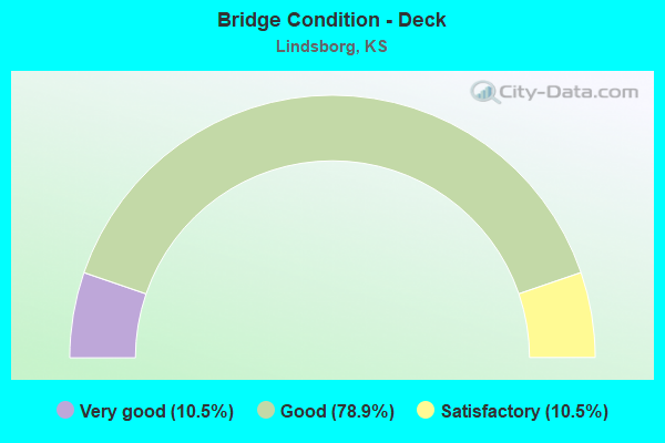
- Bridge Condition - Deck
- 10.5%Very good
- 78.9%Good
- 10.5%Satisfactory
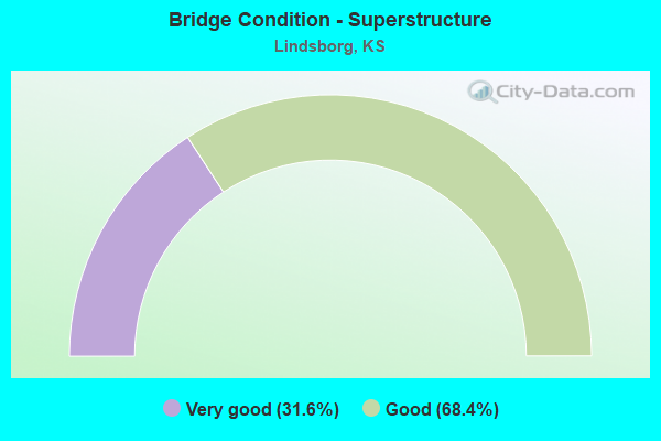
- Bridge Condition - Superstructure
- 31.6%Very good
- 68.4%Good
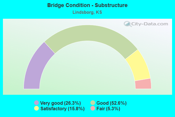
- Bridge Condition - Substructure
- 26.3%Very good
- 52.6%Good
- 15.8%Satisfactory
- 5.3%Fair

- Bridge Condition - Channel
- 11.1%Very good
- 44.4%Good
- 38.9%Satisfactory
- 5.6%Fair
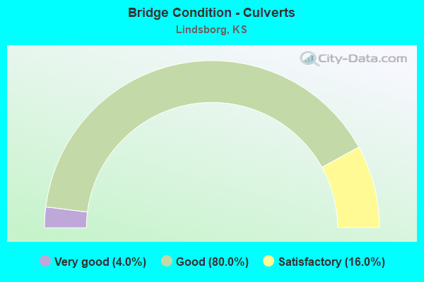
- Bridge Condition - Culverts
- 4.0%Very good
- 80.0%Good
- 16.0%Satisfactory
Find on map >> Show street view
Structure Number: 999913500590471, Location: 11.42 MI N US56 (Lat: 38.536111, Lng: -97.620556), Route carried "under" structure: Interstate 135, Year Built: 1968, Structure Length: 0. m, Average Daily Traffic: 5,616 (year 2020), Truck Traffic: 37%, Features Intersected: I135 HWY NB/SB, Facility Carried by Structure: LOCAL ROAD
Minimum Vertical Clearance: 4.88m (16.01ft), Kilometerpoint: 46.405, Lanes on structure: 2, Lanes under structure: 4, Material/Design: Concrete continuous, Design/Construction: Box Beam or Girders - Multiple, Length of Maximum Span: 20.7m (67.9ft)
Find on map >> Show street view
Structure Number: 999913500590501, Location: 1.00 MI N US81 BUS (Lat: 38.565278, Lng: -97.621111), Route carried "under" structure: Interstate 135, Year Built: 1968, Structure Length: 0. m, Average Daily Traffic: 5,312 (year 2020), Truck Traffic: 40%, Features Intersected: I135 HWY NB/SB, Facility Carried by Structure: LOCAL ROAD
Minimum Vertical Clearance: 4.91m (16.11ft), Kilometerpoint: 49.619, Lanes on structure: 2, Lanes under structure: 4, Material/Design: Concrete continuous, Design/Construction: Box Beam or Girders - Multiple, Length of Maximum Span: 20.7m (67.9ft)
Find on map >> Show street view
Structure Number: 999913500590511, Location: 2.00 MI N US81 BUS (Lat: 38.579722, Lng: -97.621111), Route carried "under" structure: Interstate 135, Year Built: 1968, Structure Length: 0. m, Average Daily Traffic: 5,312 (year 2020), Truck Traffic: 40%, Features Intersected: I135 HWY NB/SB, Facility Carried by Structure: LOCAL ROAD
Minimum Vertical Clearance: 4.85m (15.91ft), Kilometerpoint: 51.227, Lanes on structure: 2, Lanes under structure: 4, Material/Design: Concrete continuous, Design/Construction: Box Beam or Girders - Multiple, Length of Maximum Span: 20.7m (67.9ft)
Find on map >> Show street view
Structure Number: 999913500851481, Location: NJCT K-4/I-135 (Lat: 38.621944, Lng: -97.621389), Route carried "under" structure: State highway 4, Year Built: 2001, Structure Length: 0. m, Average Daily Traffic: 3,695 (year 2020), Truck Traffic: 6%, Features Intersected: K-4, Facility Carried by Structure: I-135, SB
Minimum Vertical Clearance: 6.14m (20.14ft), Kilometerpoint: 1.828, Lanes on structure: 3, Lanes under structure: 2, Material/Design: Steel continuous, Design/Construction: Stringer/Multi-beam, Length of Maximum Span: 43.0m (141.1ft)