Bridge Statistics for Loudon, Tennessee (TN)
Condition, Traffic, Stress, Structural Evaluation, Project Costs
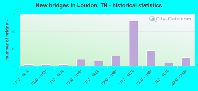
- New bridges - historical statistics
- 11910-1919
- 11920-1929
- 11930-1939
- 41940-1949
- 31950-1959
- 61960-1969
- 261970-1979
- 91980-1989
- 21990-1999
- 52000-2009
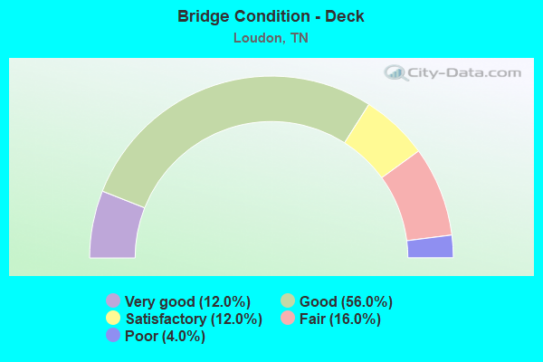
- Bridge Condition - Deck
- 12.0%Very good
- 56.0%Good
- 12.0%Satisfactory
- 16.0%Fair
- 4.0%Poor
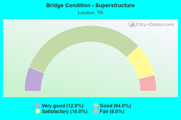
- Bridge Condition - Superstructure
- 12.0%Very good
- 64.0%Good
- 16.0%Satisfactory
- 8.0%Fair
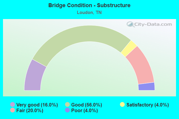
- Bridge Condition - Substructure
- 16.0%Very good
- 56.0%Good
- 4.0%Satisfactory
- 20.0%Fair
- 4.0%Poor
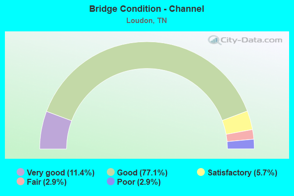
- Bridge Condition - Channel
- 11.4%Very good
- 77.1%Good
- 5.7%Satisfactory
- 2.9%Fair
- 2.9%Poor
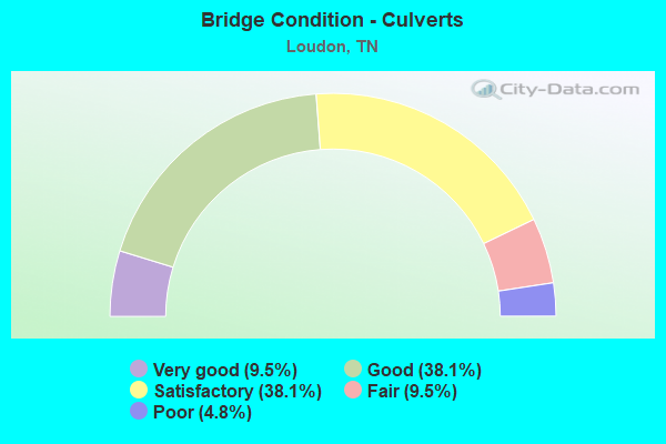
- Bridge Condition - Culverts
- 9.5%Very good
- 38.1%Good
- 38.1%Satisfactory
- 9.5%Fair
- 4.8%Poor
Find on map >> Show street view
Structure Number: 53SR0720019, Location: WEST OF LOUDON CITY (Lat: 35.729400, Lng: -84.382150), Route carried "on" structure: State highway 72, Year Built: 1974, Status: Open, Structure Length: 1.42m (4.66ft), Average Daily Traffic: 12,935 (year 2020), Truck Traffic: 8%, Average Future Daily Traffic: 20,696 (year 2041), Design Load: H 20, Features Intersected: DRY VALLEY CREEK
Minimum Vertical Clearance: 30+ m (98+ ft), Kilometerpoint: 16.110, Lanes on structure: 2, Owner: State Highway Agency, Approaching Roadway Width: 13.7m (44.9ft), Skew: 4 degrees, Material/Design: Concrete continuous, Design/Construction: Culvert, Number Of Spans In Main Unit: 3, Length of Maximum Span: 4.3m (14.1ft)
Condition: Channel: Good, Culverts: Good, Operating Rating: 89.1 metric tons, Method Used To Determine Operating Rating: Load Factor (LF), Inventory Rating: 32.4 metric tons, Method Used To Determine Inventory Rating: Load Factor (LF), Structural Evaluation: Better than present minimum criteria, Waterway Adequacy: Better than present minimum criteria, Approach Roadway Alignment: Equal to present desirable criteria, Designated Inspection Frequency: Every 24 months, Inspection Date: Febuary 2021
Find on map >> Show street view
Structure Number: 73023650003, Location: N OF TN RIVER-AT LOUDON C (Lat: 35.792667, Lng: -84.396817), Route carried "on" structure: County highway 2365, Year Built: 1968, Status: Open, Structure Length: 1.13m (3.71ft), Average Daily Traffic: 943 (year 2020), Truck Traffic: 3%, Average Future Daily Traffic: 1,509 (year 2041), Features Intersected: CAVE CREEK
Minimum Vertical Clearance: 30+ m (98+ ft), Kilometerpoint: 9.672, Lanes on structure: 2, Owner: County Highway Agency, Approaching Roadway Width: 8.2m (26.9ft), Skew: 2 degrees, Material/Design: Concrete continuous, Design/Construction: Culvert, Number Of Spans In Main Unit: 3, Length of Maximum Span: 3.7m (12.1ft)
Condition: Channel: Satisfactory, Culverts: Satisfactory, Operating Rating: 89.1 metric tons, Method Used To Determine Operating Rating: Load Factor (LF), Inventory Rating: 32.4 metric tons, Method Used To Determine Inventory Rating: Load Factor (LF), Structural Evaluation: Equal to present minimum criteria, Waterway Adequacy: Better than present minimum criteria, Approach Roadway Alignment: Equal to present desirable criteria, Designated Inspection Frequency: Every 24 months, Inspection Date: April 2021
Find on map >> Show street view
Structure Number: 730A2500001, Location: ON LOUDON CO L-AT TENN RI (Lat: 35.781517, Lng: -84.388050), Route carried "on" structure: County highway 41, Year Built: 1940, Status: Posted for load, Structure Length: 3.29m (10.79ft), Average Daily Traffic: 250 (year 2022), Truck Traffic: 2%, Average Future Daily Traffic: 400 (year 2041), Design Load: H 15, Features Intersected: HINES CREEK
Minimum Vertical Clearance: 30+ m (98+ ft), Kilometerpoint: 1.699, Lanes on structure: 2, Owner: County Highway Agency, Approaching Roadway Width: 5.5m (18.0ft), Material/Design: Concrete, Design/Construction: Tee Beam, Number Of Spans In Main Unit: 1, Length of Maximum Span: 19.5m (64.0ft), Curb-To-Curb Width: 5.5m (18.0ft), Out-to-Out Width: 6.6m (21.7ft)
Condition: Deck: Good, Superstructure: Good, Substructure: Good, Channel: Good, Operating Rating: 25.2 metric tons, Method Used To Determine Operating Rating: Load Factor (LF), Inventory Rating: 20.7 metric tons, Method Used To Determine Inventory Rating: Load Factor (LF), Structural Evaluation: Equal to present minimum criteria, Deck Geometry: High priority of corrective action, Waterway Adequacy: Better than present minimum criteria, Approach Roadway Alignment: Equal to present desirable criteria, Bridge Posting: Required (Relationship of Operating Rating to Maximum Legal Load: 0.1 - 9.9% below), Length Of Structure Improvement: 3.29m (10.79ft), Designated Inspection Frequency: Every 24 months, Inspection Date: April 2021, Bridge Improvement Cost: $240,000, Roadway Improvement Cost: $25,000, Total Project Cost: $361,000 ( Estimate for 2021), Deck Structure Type: Concrete Cast-file-Place, Wearing Surface/Protective System: Wearing Surface: Bituminous
Find on map >> Show street view
Structure Number: 730A2530001, Location: 4.5 M SW OF US70 AT CO LN (Lat: 35.806267, Lng: -84.413017), Route carried "on" structure: County highway 372, Year Built: 1934, Status: Posted for load, Structure Length: 0.73m (2.40ft), Average Daily Traffic: 70 (year 2022), Truck Traffic: 2%, Average Future Daily Traffic: 112 (year 2039), Features Intersected: WOLF CREEK
Minimum Vertical Clearance: 30+ m (98+ ft), Kilometerpoint: 0.280, Lanes on structure: 2, Owner: County Highway Agency, Approaching Roadway Width: 6.4m (21.0ft), Material/Design: Steel, Design/Construction: Stringer/Multi-beam, Number Of Spans In Main Unit: 1, Length of Maximum Span: 7.3m (24.0ft), Curb-To-Curb Width: 6.1m (20.0ft), Out-to-Out Width: 6.4m (21.0ft)
Condition: Deck: Satisfactory, Superstructure: Satisfactory, Substructure: Fair, Channel: Satisfactory, Operating Rating: 27.0 metric tons, Method Used To Determine Operating Rating: Load Factor (LF), Inventory Rating: 16.2 metric tons, Method Used To Determine Inventory Rating: Load Factor (LF), Structural Evaluation: Somewhat better than minimum adequacy, Deck Geometry: Somewhat better than minimum adequacy, Waterway Adequacy: Better than present minimum criteria, Approach Roadway Alignment: Equal to present desirable criteria, Bridge Posting: Required (Relationship of Operating Rating to Maximum Legal Load: 0.1 - 9.9% below), Length Of Structure Improvement: 0.73m (2.40ft), Designated Inspection Frequency: Every 24 months, Inspection Date: April 2021, Bridge Improvement Cost: $112,000, Roadway Improvement Cost: $12,000, Total Project Cost: $169,000 ( Estimate for 2019), Deck Structure Type: Concrete Cast-file-Place, Wearing Surface/Protective System: Wearing Surface: Bituminous
Find on map >> Show street view
Structure Number: 73S25550001, Location: BTWN TN RIVER & US70-E CO (Lat: 35.806167, Lng: -84.411883), Route carried "on" structure: County highway 2365, Year Built: 1960, Status: Open, Structure Length: 1.28m (4.20ft), Average Daily Traffic: 1,550 (year 2020), Truck Traffic: 3%, Average Future Daily Traffic: 2,096 (year 2041), Design Load: H 15, Features Intersected: WOLF CREEK
Minimum Vertical Clearance: 30+ m (98+ ft), Kilometerpoint: 3.991, Lanes on structure: 2, Owner: County Highway Agency, Approaching Roadway Width: 8.2m (26.9ft), Material/Design: Concrete continuous, Design/Construction: Culvert, Number Of Spans In Main Unit: 2, Length of Maximum Span: 3.7m (12.1ft)
Condition: Channel: Poor, Culverts: Poor, Operating Rating: 89.1 metric tons, Method Used To Determine Operating Rating: Load Factor (LF), Inventory Rating: 32.4 metric tons, Method Used To Determine Inventory Rating: Load Factor (LF), Structural Evaluation: Meets minimum limits, Waterway Adequacy: Better than present minimum criteria, Approach Roadway Alignment: Equal to present desirable criteria, Designated Inspection Frequency: Every 24 months, Inspection Date: April 2021
Find on map >> Show street view
Structure Number: 53023560001, Location: COMMERCE ST IN LOUDON (Lat: 35.739500, Lng: -84.343050), Route carried "under" structure: County highway 512, Year Built: 1986, Structure Length: 0. m, Average Daily Traffic: 2,100 (year 2022), Truck Traffic: 2%, Features Intersected: NFA 2356, Facility Carried by Structure: NFA 2356
Minimum Vertical Clearance: 4.83m (15.85ft), Kilometerpoint: 0.641, Lanes on structure: 2, Lanes under structure: 2, Material/Design: Prestressed concrete continuous, Design/Construction: Box Beam or Girders - Single/Spread, Length of Maximum Span: 16.2m (53.1ft)
Find on map >> Show street view
Structure Number: 53023560001, Location: WARD ST IN LOUDON (Lat: 35.739317, Lng: -84.342950), Route carried "under" structure: County highway 537, Year Built: 1985, Structure Length: 0. m, Average Daily Traffic: 280 (year 2022), Truck Traffic: 2%, Features Intersected: NFA 2356, Facility Carried by Structure: NFA 2356
Minimum Vertical Clearance: 3.54m (11.61ft), Kilometerpoint: 0.742, Lanes on structure: 2, Lanes under structure: 2, Material/Design: Prestressed concrete continuous, Design/Construction: Box Beam or Girders - Single/Spread, Length of Maximum Span: 16.2m (53.1ft)
Find on map >> Show street view
Structure Number: 53I00750005, Location: 7 M. NW. LENOIR CITY. (Lat: 35.713700, Lng: -84.414717), Route carried "under" structure: County highway 2349, Year Built: 1971, Structure Length: 0. m, Average Daily Traffic: 484 (year 2020), Truck Traffic: 3%, Features Intersected: I75 RT LN, Facility Carried by Structure: I75 RL
Minimum Vertical Clearance: 4.45m (14.60ft), Kilometerpoint: 2.768, Lanes on structure: 2, Lanes under structure: 2, Material/Design: Concrete continuous, Design/Construction: Tee Beam, Length of Maximum Span: 23.6m (77.4ft)
Find on map >> Show street view
Structure Number: 53I00750006, Location: 7 M. NW. LENOIR CITY. (Lat: 35.714600, Lng: -84.414600), Route carried "under" structure: County highway 2349, Year Built: 1971, Structure Length: 0. m, Average Daily Traffic: 484 (year 2020), Truck Traffic: 3%, Features Intersected: I75 LF LN, Facility Carried by Structure: I75 LL
Minimum Vertical Clearance: 4.42m (14.50ft), Kilometerpoint: 2.849, Lanes on structure: 2, Lanes under structure: 2, Material/Design: Concrete continuous, Design/Construction: Tee Beam, Length of Maximum Span: 23.6m (77.4ft)
Find on map >> Show street view
Structure Number: 53I00750009, Location: 3 MILES W OF LOUDON (Lat: 35.732700, Lng: -84.394817), Route carried "under" structure: Interstate 75, Year Built: 1969, Structure Length: 0. m, Average Daily Traffic: 49,224 (year 2020), Truck Traffic: 27%, Features Intersected: SR 72, Facility Carried by Structure: FAP 72
Minimum Vertical Clearance: 5.39m (17.68ft), Kilometerpoint: 9.125, Lanes on structure: 2, Lanes under structure: 4, Material/Design: Concrete continuous, Design/Construction: Box Beam or Girders - Single/Spread, Length of Maximum Span: 28.3m (92.8ft)
Find on map >> Show street view
Structure Number: 53I0075001, Location: 3 MILES W OF LOUDON (Lat: 35.732600, Lng: -84.394883), Route carried "under" structure: Interstate 75, Year Built: 1969, Structure Length: 0. m, Average Daily Traffic: 44,875 (year 2020), Truck Traffic: 33%, Features Intersected: SR 72, Facility Carried by Structure: FAP 72
Minimum Vertical Clearance: 5.01m (16.44ft), Kilometerpoint: 9.093, Lanes on structure: 2, Lanes under structure: 4, Material/Design: Concrete continuous, Design/Construction: Box Beam or Girders - Single/Spread, Length of Maximum Span: 28.4m (93.2ft)
Find on map >> Show street view
Structure Number: 53I00750013, Location: 2.5 M. W. LOUDON. (Lat: 35.748633, Lng: -84.381233), Route carried "under" structure: County highway 658, Year Built: 1972, Structure Length: 0. m, Average Daily Traffic: 70 (year 2022), Truck Traffic: 2%, Features Intersected: MATLOCK BEND RD., Facility Carried by Structure: I-75 NB
Minimum Vertical Clearance: 6.51m (21.36ft), Kilometerpoint: 1.379, Lanes on structure: 2, Lanes under structure: 2, Material/Design: Prestressed concrete continuous, Design/Construction: Box Beam or Girders - Single/Spread, Length of Maximum Span: 17.7m (58.1ft)
Find on map >> Show street view
Structure Number: 53I00750014, Location: 2.5 M. W. LOUDON. (Lat: 35.748850, Lng: -84.381417), Route carried "under" structure: County highway 658, Year Built: 1972, Structure Length: 0. m, Average Daily Traffic: 70 (year 2022), Truck Traffic: 2%, Features Intersected: MATLOCK BEND RD., Facility Carried by Structure: I-75 SB
Minimum Vertical Clearance: 4.35m (14.27ft), Kilometerpoint: 1.352, Lanes on structure: 2, Lanes under structure: 2, Material/Design: Prestressed concrete continuous, Design/Construction: Box Beam or Girders - Single/Spread, Length of Maximum Span: 17.7m (58.1ft)
Find on map >> Show street view
Structure Number: 53I00750017, Location: 1 MI N TN RIVER (Lat: 35.763983, Lng: -84.364317), Route carried "under" structure: Interstate 75, Year Built: 1971, Structure Length: 0. m, Average Daily Traffic: 49,224 (year 2020), Truck Traffic: 27%, Features Intersected: HOTCHKISS VALLEY RD-A035, Facility Carried by Structure: NFA A035
Minimum Vertical Clearance: 5.00m (16.40ft), Kilometerpoint: 13.599, Lanes on structure: 2, Lanes under structure: 4, Material/Design: Concrete continuous, Design/Construction: Box Beam or Girders - Single/Spread, Length of Maximum Span: 40.5m (132.9ft)
Find on map >> Show street view
Structure Number: 53I00750021, Location: NEAR EATON TENN. (Lat: 35.783300, Lng: -84.344067), Route carried "under" structure: Interstate 75, Year Built: 1971, Structure Length: 0. m, Average Daily Traffic: 50,703 (year 2020), Truck Traffic: 27%, Features Intersected: NFA 1251 SUGAR LIMB RD, Facility Carried by Structure: NFA 1251
Minimum Vertical Clearance: 4.88m (16.01ft), Kilometerpoint: 16.383, Lanes on structure: 2, Lanes under structure: 4, Material/Design: Concrete, Design/Construction: Box Beam or Girders - Multiple, Length of Maximum Span: 36.6m (120.1ft)
Find on map >> Show street view
Structure Number: 53SR0020005, Location: AT TENN RIVER (Lat: 35.742183, Lng: -84.334967), Route carried "under" structure: City street 528, Year Built: 2004, Structure Length: 0. m, Average Daily Traffic: 860 (year 2022), Truck Traffic: 5%, Features Intersected: SR 2, Facility Carried by Structure: FAP 2
Minimum Vertical Clearance: 4.65m (15.26ft), Kilometerpoint: 0.256, Lanes on structure: 2, Lanes under structure: 2, Material/Design: Steel continuous, Design/Construction: Stringer/Multi-beam, Length of Maximum Span: 107.0m (351.0ft)
Find on map >> Show street view
Structure Number: 53SR0020005, Location: AT TN RIVER (Lat: 35.743333, Lng: -84.326750), Route carried "under" structure: City street 19, Year Built: 2004, Structure Length: 0. m, Average Daily Traffic: 200 (year 2022), Truck Traffic: 5%, Features Intersected: SR 2, Facility Carried by Structure: FAP 2
Minimum Vertical Clearance: 4.42m (14.50ft), Kilometerpoint: 0.322, Lanes on structure: 2, Lanes under structure: 2, Material/Design: Steel, Design/Construction: Truss - Thru, Length of Maximum Span: 107.0m (351.0ft)