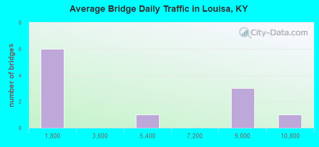
Bridge Statistics for Louisa, Kentucky (KY)
Condition, Traffic, Stress, Structural Evaluation, Project Costs
- National Bridge Inventory (NBI) Statistics
- 11Number of bridges
- 230ft / 69.7mTotal length
- $2,787,000Total costs
- 42,404Total average daily traffic
- 3,749Total average daily truck traffic
- National Bridge Inventory (NBI) Registered Bridges for Louisa
- No street view available for this location
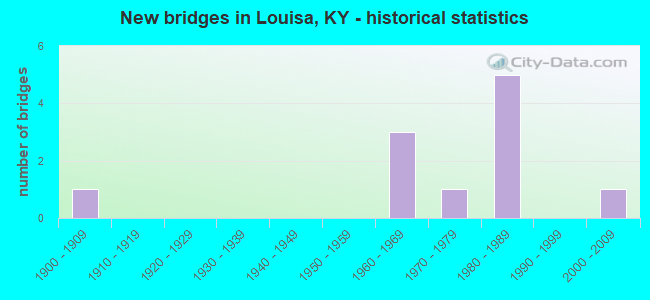
- New bridges - historical statistics
- 11900-1909
- 31960-1969
- 11970-1979
- 51980-1989
- 12000-2009
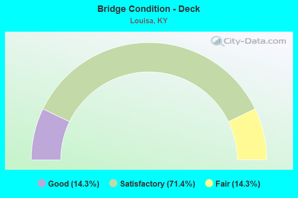
- Bridge Condition - Deck
- 14.3%Good
- 71.4%Satisfactory
- 14.3%Fair
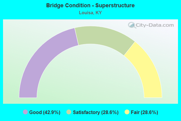
- Bridge Condition - Superstructure
- 42.9%Good
- 28.6%Satisfactory
- 28.6%Fair

- Bridge Condition - Substructure
- 14.3%Good
- 42.9%Satisfactory
- 28.6%Fair
- 14.3%Poor
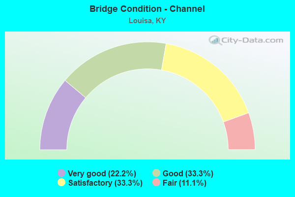
- Bridge Condition - Channel
- 22.2%Very good
- 33.3%Good
- 33.3%Satisfactory
- 11.1%Fair
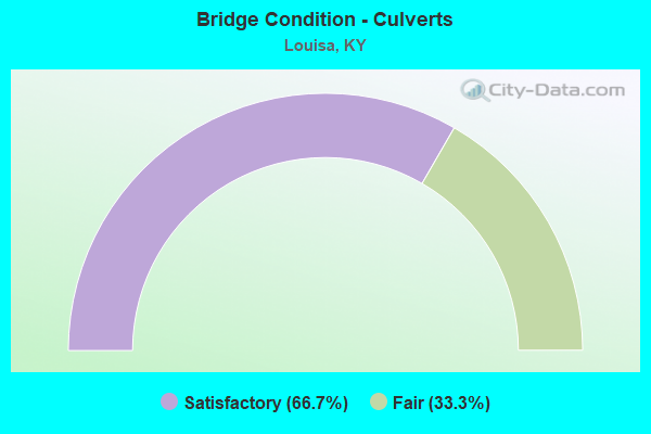
- Bridge Condition - Culverts
- 66.7%Satisfactory
- 33.3%Fair
Find on map >> Show street view
Structure Number: 64B00007N, Location: 1.8 MI N OF JCT KY 2038 (Lat: 38.048611, Lng: -82.643333), Route carried "on" structure: US 23, Year Built: 1969, Status: Open, Structure Length: 0.79m (2.59ft), Average Daily Traffic: 7,603 (year 2020), Truck Traffic: 17%, Average Future Daily Traffic: 7,146 (year 2040), Design Load: HS 20, Features Intersected: RHUBENS CREEK
Minimum Vertical Clearance: 30+ m (98+ ft), Kilometerpoint: 20.217, Lanes on structure: 4, Base Highway Network: Yes, Owner: State Highway Agency, Approaching Roadway Width: 26.8m (87.9ft), Skew: 22 degrees, Material/Design: Concrete, Design/Construction: Culvert, Number Of Spans In Main Unit: 2, Length of Maximum Span: 3.4m (11.2ft)
Condition: Channel: Good, Culverts: Satisfactory, Operating Rating: 54.4 metric tons, Method Used To Determine Operating Rating: Field evaluation and documented engineering judgment, Inventory Rating: 40.8 metric tons, Method Used To Determine Inventory Rating: Field evaluation and documented engineering judgment, Structural Evaluation: Equal to present minimum criteria, Waterway Adequacy: Equal to present desirable criteria, Approach Roadway Alignment: Equal to present desirable criteria, Designated Inspection Frequency: Every 24 months, Inspection Date: April 2020
Find on map >> Show street view
Structure Number: 64B00038N, Location: 0.25 MI NW of JCT KY 1690 (Lat: 38.080556, Lng: -82.600000), Route carried "on" structure: State highway 644, Year Built: 1904, Year Reconstructed: 1970, Status: Posted for load, Structure Length: 14.48m (47.51ft), Average Daily Traffic: 1,166 (year 2015), Truck Traffic: 3%, Average Future Daily Traffic: 1,026 (year 2035), Design Load: H 10, Features Intersected: Levisa Fork
Minimum Vertical Clearance: 4.27m (14.01ft), Kilometerpoint: 2.435, Lanes on structure: 1, Owner: State Highway Agency, Approaching Roadway Width: 5.5m (18.0ft), Material/Design: Steel, Design/Construction: Truss - Thru, Number Of Spans In Main Unit: 3, Number Of Approach Spans: 1, Length of Maximum Span: 52.3m (171.6ft), Curb-To-Curb Width: 3.4m (11.2ft), Out-to-Out Width: 3.8m (12.5ft)
Condition: Deck: Satisfactory, Superstructure: Fair, Substructure: Fair, Channel: Satisfactory, Operating Rating: 17.9 metric tons, Method Used To Determine Operating Rating: Load Factor (LF), Inventory Rating: 10.7 metric tons, Method Used To Determine Inventory Rating: Load Factor (LF), Structural Evaluation: High priority of replacement, Deck Geometry: High priority of replacement, Waterway Adequacy: Equal to present desirable criteria, Approach Roadway Alignment: Equal to present minimum criteria, Bridge Posting: Required (Relationship of Operating Rating to Maximum Legal Load: > 39.9% below), Length Of Structure Improvement: 1.43m (4.69ft), Designated Inspection Frequency: Every 12 months, Critical Feature Inspection Frequency: Every 24 months, Underwater Inspection Frequency: Every 60 months, Inspection Date: October 2021, Critical Feature Inspection Date: September 2020, Underwater Inspection Date: June 2020, Bridge Improvement Cost: $945,000, Roadway Improvement Cost: $100,000, Total Project Cost: $1,044,000, Deck Structure Type: Concrete Cast-file-Place, Wearing Surface/Protective System: Wearing Surface: Monolithic Concrete, Deck Protection: Epoxy Coated Reinforcing
Find on map >> Show street view
Structure Number: 64B00060N, Location: 0.1 MI NE-MAIN ST-KY 2566 (Lat: 38.116389, Lng: -82.600000), Route carried "on" structure: State highway 3, Year Built: 1977, Status: Posted for load, Structure Length: 37.37m (122.60ft), Average Daily Traffic: 7,480 (year 2020), Truck Traffic: 5%, Average Future Daily Traffic: 6,208 (year 2040), Design Load: HS 20+Mod, Features Intersected: LEVISA & TUG FORK
Minimum Vertical Clearance: 30+ m (98+ ft), Kilometerpoint: 24.135, Lanes on structure: 2, Base Highway Network: Yes, Owner: State Highway Agency, Approaching Roadway Width: 9.8m (32.2ft), Material/Design: Steel continuous, Design/Construction: Stringer/Multi-beam, Number Of Spans In Main Unit: 9, Number Of Approach Spans: 4, Length of Maximum Span: 64.0m (210.0ft), Curb or Sidewalk Widths: Left: 0.0m, Right: 2.4m (7.9ft), Curb-To-Curb Width: 9.8m (32.2ft), Out-to-Out Width: 13.4m (44.0ft)
Condition: Deck: Fair, Superstructure: Fair, Substructure: Fair, Channel: Satisfactory, Operating Rating: 36.3 metric tons, Method Used To Determine Operating Rating: Field evaluation and documented engineering judgment, Inventory Rating: 18.1 metric tons, Method Used To Determine Inventory Rating: Field evaluation and documented engineering judgment, Structural Evaluation: Meets minimum limits, Deck Geometry: Meets minimum limits, Waterway Adequacy: Equal to present desirable criteria, Approach Roadway Alignment: Equal to present desirable criteria, Bridge Posting: Required (Relationship of Operating Rating to Maximum Legal Load: > 39.9% below), Designated Inspection Frequency: Every 24 months, Underwater Inspection Frequency: Every 60 months, Other Special Inspection Frequency: Every 72 months, Inspection Date: April 2021, Underwater Inspection Date: July 2020, Other Special Inspection Date: April 2021, Deck Structure Type: Concrete Cast-file-Place, Wearing Surface/Protective System: Wearing Surface: Monolithic Concrete
Find on map >> Show street view
Structure Number: 64B00068N, Location: 2.4 MI. N - JCT KY 2037 (Lat: 38.045556, Lng: -82.589167), Route carried "on" structure: State highway 1690, Year Built: 1984, Status: Open, Structure Length: 0.91m (2.99ft), Average Daily Traffic: 642 (year 2019), Average Future Daily Traffic: 564 (year 2039), Design Load: HS 20, Features Intersected: THREEMILE CREEK
Minimum Vertical Clearance: 30+ m (98+ ft), Kilometerpoint: 20.178, Lanes on structure: 2, Owner: State Highway Agency, Approaching Roadway Width: 6.7m (22.0ft), Material/Design: Concrete, Design/Construction: Culvert, Number Of Spans In Main Unit: 2, Length of Maximum Span: 3.0m (9.8ft)
Condition: Channel: Good, Culverts: Satisfactory, Operating Rating: 73.7 metric tons, Method Used To Determine Operating Rating: Load Factor (LF), Inventory Rating: 44.2 metric tons, Method Used To Determine Inventory Rating: Load Factor (LF), Structural Evaluation: Equal to present minimum criteria, Waterway Adequacy: Equal to present desirable criteria, Approach Roadway Alignment: Equal to present desirable criteria, Designated Inspection Frequency: Every 24 months, Inspection Date: April 2020
Find on map >> Show street view
Structure Number: 64B00077N, Location: 1.5 MI S of JCT KY-3 N (Lat: 38.105000, Lng: -82.626944), Route carried "on" structure: US 23, Year Built: 1989, Status: Open, Structure Length: 3.41m (11.19ft), Average Daily Traffic: 8,127 (year 2020), Truck Traffic: 15%, Average Future Daily Traffic: 7,639 (year 2040), Design Load: HS 25 or greater, Features Intersected: KY-32
Minimum Vertical Clearance: 30+ m (98+ ft), Kilometerpoint: 27.159, Lanes on structure: 4, Lanes under structure: 2, Base Highway Network: Yes, Owner: State Highway Agency, Approaching Roadway Width: 25.0m (82.0ft), Skew: 21 degrees, Material/Design: Prestressed concrete, Design/Construction: Stringer/Multi-beam, Number Of Spans In Main Unit: 1, Length of Maximum Span: 34.1m (111.9ft), Curb-To-Curb Width: 25.0m (82.0ft), Out-to-Out Width: 26.1m (85.6ft)
Condition: Deck: Satisfactory, Superstructure: Good, Substructure: Satisfactory, Operating Rating: 99.0 metric tons, Method Used To Determine Operating Rating: Load Factor (LF), Inventory Rating: 59.4 metric tons, Method Used To Determine Inventory Rating: Load Factor (LF), Structural Evaluation: Equal to present minimum criteria, Deck Geometry: Superior to present desirable criteria, Underclear: Superior to present desirable criteria, Approach Roadway Alignment: Equal to present desirable criteria, Designated Inspection Frequency: Every 24 months, Inspection Date: April 2021, Deck Structure Type: Concrete Cast-file-Place, Wearing Surface/Protective System: Wearing Surface: Monolithic Concrete, Deck Protection: Epoxy Coated Reinforcing
Find on map >> Show street view
Structure Number: 64B00084N, Location: @ JCT KY 644/KY 2565 (Lat: 38.092222, Lng: -82.610000), Route carried "on" structure: State highway 644, Year Built: 2000, Status: Open, Structure Length: 2.50m (8.20ft), Average Daily Traffic: 4,618 (year 2020), Truck Traffic: 5%, Average Future Daily Traffic: 4,063 (year 2040), Design Load: HS 25 or greater, Features Intersected: Lick Creek
Minimum Vertical Clearance: 30+ m (98+ ft), Kilometerpoint: 0.034, Lanes on structure: 2, Owner: State Highway Agency, Approaching Roadway Width: 17.4m (57.1ft), Material/Design: Prestressed concrete, Design/Construction: Stringer/Multi-beam, Number Of Spans In Main Unit: 1, Length of Maximum Span: 22.9m (75.1ft), Curb or Sidewalk Widths: Left: 2.4m (7.9ft), Right: 0.0m, Curb-To-Curb Width: 14.8m (48.6ft), Out-to-Out Width: 18.3m (60.0ft)
Condition: Deck: Satisfactory, Superstructure: Good, Substructure: Satisfactory, Channel: Very good, Operating Rating: 77.2 metric tons, Method Used To Determine Operating Rating: Load Factor (LF), Inventory Rating: 46.3 metric tons, Method Used To Determine Inventory Rating: Load Factor (LF), Structural Evaluation: Equal to present minimum criteria, Deck Geometry: Superior to present desirable criteria, Waterway Adequacy: Equal to present desirable criteria, Approach Roadway Alignment: Better than present minimum criteria, Designated Inspection Frequency: Every 24 months, Inspection Date: April 2020, Bridge Improvement Cost: $1,577,000, Total Project Cost: $1,577,000, Deck Structure Type: Concrete Cast-file-Place, Wearing Surface/Protective System: Wearing Surface: Monolithic Concrete, Deck Protection: Epoxy Coated Reinforcing
Find on map >> Show street view
Structure Number: 64C00001N, Location: 1.2 MI NE US 23/KY 2565 (Lat: 38.084444, Lng: -82.614722), Route carried "on" structure: County highway 1090, Year Built: 1960, Status: Open, Structure Length: 1.19m (3.90ft), Average Daily Traffic: 27 (year 2011), Average Future Daily Traffic: 23 (year 2031), Features Intersected: Lick Creek, Facility Carried by Structure: Southside Loop Rd
Minimum Vertical Clearance: 30+ m (98+ ft), Kilometerpoint: 0.404, Lanes on structure: 1, Owner: County Highway Agency, Approaching Roadway Width: 6.4m (21.0ft), Skew: 3 degrees, Material/Design: Concrete, Design/Construction: Culvert, Number Of Spans In Main Unit: 4, Length of Maximum Span: 2.7m (8.9ft)
Condition: Channel: Fair, Culverts: Fair, Operating Rating: 54.4 metric tons, Method Used To Determine Operating Rating: Field evaluation and documented engineering judgment, Inventory Rating: 39.9 metric tons, Method Used To Determine Inventory Rating: Field evaluation and documented engineering judgment, Structural Evaluation: Somewhat better than minimum adequacy, Waterway Adequacy: Better than present minimum criteria, Approach Roadway Alignment: Equal to present desirable criteria, Designated Inspection Frequency: Every 24 months, Inspection Date: November 2021
Find on map >> Show street view
Structure Number: 64C00006N, Location: 0.85 MI W of JCT KY 3 (Lat: 38.147778, Lng: -82.685556), Route carried "on" structure: County highway 1064, Year Built: 1968, Status: Posted for load, Structure Length: 4.39m (14.40ft), Average Daily Traffic: 885 (year 2011), Average Future Daily Traffic: 769 (year 2031), Features Intersected: Blaine Creek, Facility Carried by Structure: Yatesville Rd
Minimum Vertical Clearance: 30+ m (98+ ft), Kilometerpoint: 1.434, Lanes on structure: 1, Owner: County Highway Agency, Approaching Roadway Width: 4.3m (14.1ft), Material/Design: Concrete, Design/Construction: Tee Beam, Number Of Spans In Main Unit: 3, Length of Maximum Span: 14.6m (47.9ft), Curb or Sidewalk Widths: Left: 0.5m (1.6ft), Right: 0.5m (1.6ft), Curb-To-Curb Width: 4.4m (14.4ft), Out-to-Out Width: 5.5m (18.0ft)
Condition: Deck: Satisfactory, Superstructure: Good, Substructure: Good, Channel: Good, Operating Rating: 16.4 metric tons, Method Used To Determine Operating Rating: Field evaluation and documented engineering judgment, Inventory Rating: 16.4 metric tons, Method Used To Determine Inventory Rating: Field evaluation and documented engineering judgment, Structural Evaluation: Meets minimum limits, Deck Geometry: High priority of replacement, Waterway Adequacy: Equal to present desirable criteria, Approach Roadway Alignment: Equal to present minimum criteria, Bridge Posting: Required (Relationship of Operating Rating to Maximum Legal Load: > 39.9% below), Designated Inspection Frequency: Every 24 months, Inspection Date: November 2020, Deck Structure Type: Concrete Cast-file-Place, Wearing Surface/Protective System: Wearing Surface: Monolithic Concrete
Find on map >> Show street view
Structure Number: 64C00038N, Location: 200 FT S. - KY 2565 (Lat: 38.107222, Lng: -82.599722), Route carried "on" structure: City street 2176, Year Built: 1980, Status: Open, Structure Length: 2.44m (8.01ft), Average Daily Traffic: 1,300 (year 2011), Average Future Daily Traffic: 1,131 (year 2031), Design Load: HS 20, Features Intersected: LICK CREEK, Facility Carried by Structure: ELOISE PREECE ST
Minimum Vertical Clearance: 30+ m (98+ ft), Kilometerpoint: 0.056, Lanes on structure: 2, Owner: County Highway Agency, Approaching Roadway Width: 4.9m (16.1ft), Material/Design: Prestressed concrete, Design/Construction: Box Beam or Girders - Multiple, Number Of Spans In Main Unit: 1, Length of Maximum Span: 24.4m (80.1ft), Curb-To-Curb Width: 6.1m (20.0ft), Out-to-Out Width: 6.6m (21.7ft)
Condition: Deck: Satisfactory, Superstructure: Satisfactory, Substructure: Poor, Channel: Satisfactory, Operating Rating: 99.8 metric tons, Method Used To Determine Operating Rating: Load Factor (LF), Inventory Rating: 60.8 metric tons, Method Used To Determine Inventory Rating: Load Factor (LF), Structural Evaluation: Meets minimum limits, Deck Geometry: High priority of replacement, Waterway Adequacy: Equal to present desirable criteria, Approach Roadway Alignment: Equal to present minimum criteria, Designated Inspection Frequency: Every 24 months, Inspection Date: November 2020, Deck Structure Type: Concrete Precast Panels, Wearing Surface/Protective System: Wearing Surface: Bituminous
Find on map >> Show street view
Structure Number: 64C00042N, Location: 300' SW OF JCT KY 2566 (Lat: 38.106944, Lng: -82.603056), Route carried "on" structure: County highway 1011, Year Built: 1986, Status: Open, Structure Length: 2.26m (7.41ft), Average Daily Traffic: 548 (year 2011), Average Future Daily Traffic: 476 (year 2031), Design Load: HS 20, Features Intersected: LICK CREEK, Facility Carried by Structure: BLACKERRY AVE
Minimum Vertical Clearance: 30+ m (98+ ft), Kilometerpoint: 0.154, Lanes on structure: 2, Owner: County Highway Agency, Approaching Roadway Width: 4.9m (16.1ft), Material/Design: Prestressed concrete, Design/Construction: Box Beam or Girders - Multiple, Number Of Spans In Main Unit: 1, Length of Maximum Span: 21.9m (71.9ft), Curb-To-Curb Width: 5.0m (16.4ft), Out-to-Out Width: 5.5m (18.0ft)
Condition: Deck: Good, Superstructure: Satisfactory, Substructure: Satisfactory, Channel: Very good, Operating Rating: 83.8 metric tons, Method Used To Determine Operating Rating: Load Factor (LF), Inventory Rating: 50.3 metric tons, Method Used To Determine Inventory Rating: Load Factor (LF), Structural Evaluation: Equal to present minimum criteria, Deck Geometry: High priority of replacement, Waterway Adequacy: Equal to present desirable criteria, Approach Roadway Alignment: Equal to present desirable criteria, Length Of Structure Improvement: 0.23m (0.75ft), Designated Inspection Frequency: Every 24 months, Inspection Date: November 2020, Bridge Improvement Cost: $166,000, Total Project Cost: $166,000, Deck Structure Type: Concrete Precast Panels, Wearing Surface/Protective System: Wearing Surface: Bituminous
Find on map >> Show street view
Structure Number: 64B00077N, Location: 1.5 MI S of JCT KY-3 N (Lat: 38.105000, Lng: -82.626944), Route carried "under" structure: State highway 32, Year Built: 1989, Structure Length: 0. m, Average Daily Traffic: 10,008 (year 2019), Truck Traffic: 6%, Features Intersected: KY-32, Facility Carried by Structure: US-23
Minimum Vertical Clearance: 30+ m (98+ ft), Kilometerpoint: 44.268, Lanes on structure: 4, Lanes under structure: 2, Material/Design: Prestressed concrete, Design/Construction: Stringer/Multi-beam, Length of Maximum Span: 34.1m (111.9ft)