Bridge Statistics for Ludlow, Vermont (VT)
Condition, Traffic, Stress, Structural Evaluation, Project Costs
- National Bridge Inventory (NBI) Statistics
- 20Number of bridges
- 125ft / 37.7mTotal length
- $5,940,000Total costs
- 73,356Total average daily traffic
- 5,651Total average daily truck traffic
- National Bridge Inventory (NBI) Registered Bridges for Ludlow
- No street view available for this location
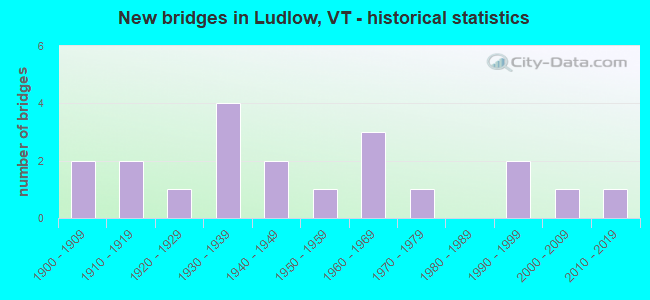
- New bridges - historical statistics
- 21900-1909
- 21910-1919
- 11920-1929
- 41930-1939
- 21940-1949
- 11950-1959
- 31960-1969
- 11970-1979
- 21990-1999
- 12000-2009
- 12010-2019
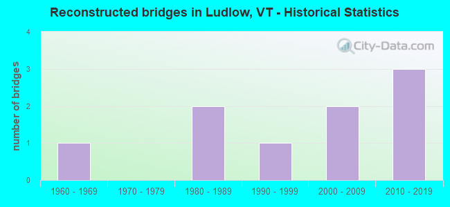
- Reconstructed bridges - Historical Statistics
- 11960-1969
- 01970-1979
- 21980-1989
- 11990-1999
- 22000-2009
- 32010-2019
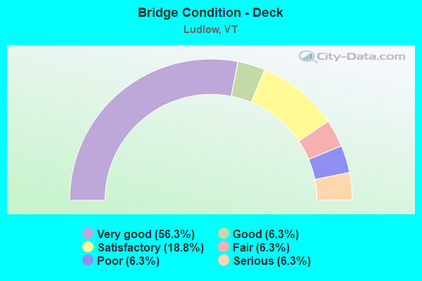
- Bridge Condition - Deck
- 56.3%Very good
- 6.3%Good
- 18.8%Satisfactory
- 6.3%Fair
- 6.3%Poor
- 6.3%Serious
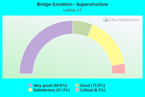
- Bridge Condition - Superstructure
- 50.0%Very good
- 12.5%Good
- 31.3%Satisfactory
- 6.3%Critical
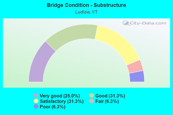
- Bridge Condition - Substructure
- 25.0%Very good
- 31.3%Good
- 31.3%Satisfactory
- 6.3%Fair
- 6.3%Poor
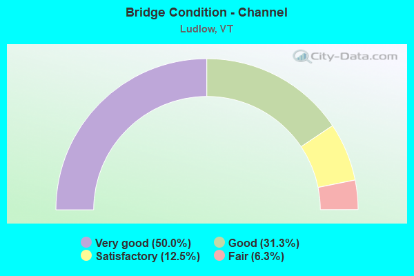
- Bridge Condition - Channel
- 50.0%Very good
- 31.3%Good
- 12.5%Satisfactory
- 6.3%Fair
Find on map >> Show street view
Structure Number: 101410000214101, Location: @ JCT W VT100 (Lat: 43.406111, Lng: -72.707614), Route carried "on" structure: Other road C2003, Year Built: 1995, Status: Open, Structure Length: 1.74m (5.71ft), Average Daily Traffic: 1,056 (year 2019), Truck Traffic: 10%, Average Future Daily Traffic: 1,109 (year 2029), Design Load: HS 25 or greater, Features Intersected: BLACK RIVER
Minimum Vertical Clearance: 30+ m (98+ ft), Kilometerpoint: 0.000, Lanes on structure: 2, Owner: Town or Township Highway Agency, Approaching Roadway Width: 8.5m (27.9ft), Material/Design: Steel, Design/Construction: Stringer/Multi-beam, Number Of Spans In Main Unit: 1, Length of Maximum Span: 16.8m (55.1ft), Curb or Sidewalk Widths: Left: 0.2m (0.7ft), Right: 0.2m (0.7ft), Curb-To-Curb Width: 8.2m (26.9ft), Out-to-Out Width: 8.9m (29.2ft)
Condition: Deck: Very good, Superstructure: Very good, Substructure: Very good, Channel: Very good, Operating Rating: 74.4 metric tons, Method Used To Determine Operating Rating: Allowable Stress (AS), Inventory Rating: 46.3 metric tons, Method Used To Determine Inventory Rating: Allowable Stress (AS), Structural Evaluation: Equal to present desirable criteria, Deck Geometry: Meets minimum limits, Waterway Adequacy: Better than present minimum criteria, Approach Roadway Alignment: Equal to present desirable criteria, Designated Inspection Frequency: Every 24 months, Inspection Date: September 2021, Deck Structure Type: Concrete Cast-file-Place, Wearing Surface/Protective System: Wearing Surface: Bituminous, Membrane: Preformed Fabric, Deck Protection: Epoxy Coated Reinforcing
Find on map >> Show street view
Structure Number: 101410000614101, Location: 0.01 MI TO JCT W VT100 (Lat: 43.429175, Lng: -72.698136), Route carried "on" structure: Other road C2004, Year Built: 1919, Year Reconstructed: 2012, Status: Open, Structure Length: 2.01m (6.59ft), Average Daily Traffic: 150 (year 2019), Truck Traffic: 2%, Average Future Daily Traffic: 158 (year 2029), Design Load: HS 20, Features Intersected: BLACK RIVER
Minimum Vertical Clearance: 30+ m (98+ ft), Kilometerpoint: 0.000, Lanes on structure: 2, Owner: Town or Township Highway Agency, Approaching Roadway Width: 7.0m (23.0ft), Skew: 1 degrees, Material/Design: Prestressed concrete, Design/Construction: Box Beam or Girders - Multiple, Number Of Spans In Main Unit: 1, Length of Maximum Span: 19.2m (63.0ft), Curb-To-Curb Width: 6.8m (22.3ft), Out-to-Out Width: 7.3m (24.0ft)
Condition: Deck: Very good, Superstructure: Very good, Substructure: Good, Channel: Very good, Operating Rating: 78.0 metric tons, Method Used To Determine Operating Rating: Load Factor (LF), Inventory Rating: 46.3 metric tons, Method Used To Determine Inventory Rating: Load Factor (LF), Structural Evaluation: Better than present minimum criteria, Deck Geometry: Meets minimum limits, Waterway Adequacy: Equal to present desirable criteria, Approach Roadway Alignment: Equal to present desirable criteria, Designated Inspection Frequency: Every 24 months, Inspection Date: September 2021, Deck Structure Type: Concrete Precast Panels, Wearing Surface/Protective System: Wearing Surface: Bituminous, Membrane: Preformed Fabric
Find on map >> Show street view
Structure Number: 101410000814101, Location: 0.18 MI TO JCT W VT100 (Lat: 43.445117, Lng: -72.698819), Route carried "on" structure: Other road C3008, Year Built: 1948, Year Reconstructed: 2002, Status: Open, Structure Length: 2.26m (7.41ft), Average Daily Traffic: 150 (year 2019), Truck Traffic: 2%, Average Future Daily Traffic: 158 (year 2029), Design Load: HS 25 or greater, Features Intersected: LAKE RESCUE
Minimum Vertical Clearance: 30+ m (98+ ft), Kilometerpoint: 0.000, Lanes on structure: 1, Owner: Town or Township Highway Agency, Approaching Roadway Width: 4.9m (16.1ft), Material/Design: Steel, Design/Construction: Stringer/Multi-beam, Number Of Spans In Main Unit: 1, Length of Maximum Span: 21.9m (71.9ft), Curb or Sidewalk Widths: Left: 0.2m (0.7ft), Right: 0.2m (0.7ft), Curb-To-Curb Width: 4.1m (13.5ft), Out-to-Out Width: 4.9m (16.1ft)
Condition: Deck: Very good, Superstructure: Very good, Substructure: Satisfactory, Channel: Very good, Operating Rating: 84.4 metric tons, Method Used To Determine Operating Rating: Load Factor (LF), Inventory Rating: 50.8 metric tons, Method Used To Determine Inventory Rating: Load Factor (LF), Structural Evaluation: Equal to present minimum criteria, Deck Geometry: High priority of replacement, Waterway Adequacy: Equal to present desirable criteria, Approach Roadway Alignment: Equal to present minimum criteria, Designated Inspection Frequency: Every 24 months, Inspection Date: September 2021, Deck Structure Type: Concrete Cast-file-Place, Wearing Surface/Protective System: Wearing Surface: Bituminous, Membrane: Preformed Fabric, Deck Protection: Epoxy Coated Reinforcing
Find on map >> Show street view
Structure Number: 101410001214101, Location: 0.01 MI TO JCT W C3 TH53 (Lat: 43.430425, Lng: -72.717036), Route carried "on" structure: Other road C3014, Year Built: 1935, Year Reconstructed: 2019, Status: Open, Structure Length: 1.22m (4.00ft), Average Daily Traffic: 80 (year 2019), Truck Traffic: 2%, Average Future Daily Traffic: 84 (year 2029), Design Load: HL 93, Features Intersected: BRANCH BROOK
Minimum Vertical Clearance: 30+ m (98+ ft), Kilometerpoint: 0.000, Lanes on structure: 1, Owner: Town or Township Highway Agency, Approaching Roadway Width: 5.2m (17.1ft), Material/Design: Concrete, Design/Construction: Slab, Number Of Spans In Main Unit: 1, Length of Maximum Span: 11.6m (38.1ft), Curb-To-Curb Width: 5.1m (16.7ft), Out-to-Out Width: 5.5m (18.0ft)
Condition: Deck: Very good, Superstructure: Very good, Substructure: Good, Channel: Very good, Operating Rating: 48.1 metric tons, Method Used To Determine Operating Rating: Load and Resistance Factor (LRFR), Inventory Rating: 37.2 metric tons, Method Used To Determine Inventory Rating: Load and Resistance Factor (LRFR), Structural Evaluation: Better than present minimum criteria, Deck Geometry: High priority of corrective action, Waterway Adequacy: Equal to present minimum criteria, Approach Roadway Alignment: Equal to present desirable criteria, Designated Inspection Frequency: Every 24 months, Inspection Date: September 2021, Deck Structure Type: Concrete Cast-file-Place, Wearing Surface/Protective System: Wearing Surface: Monolithic Concrete, Deck Protection: Epoxy Coated Reinforcing
Find on map >> Show street view
Structure Number: 101410001414101, Location: 0.08 MI TO JCT W VT103 (Lat: 43.414814, Lng: -72.703422), Route carried "on" structure: Other road C3017, Year Built: 1974, Status: Open, Structure Length: 2.47m (8.10ft), Average Daily Traffic: 100 (year 2019), Truck Traffic: 2%, Average Future Daily Traffic: 105 (year 2029), Design Load: H 20, Features Intersected: BLACK RIVER
Minimum Vertical Clearance: 30+ m (98+ ft), Kilometerpoint: 0.000, Lanes on structure: 2, Owner: Town or Township Highway Agency, Approaching Roadway Width: 7.3m (24.0ft), Material/Design: Steel, Design/Construction: Stringer/Multi-beam, Number Of Spans In Main Unit: 1, Length of Maximum Span: 24.1m (79.1ft), Curb or Sidewalk Widths: Left: 0.2m (0.7ft), Right: 0.2m (0.7ft), Curb-To-Curb Width: 6.8m (22.3ft), Out-to-Out Width: 7.4m (24.3ft)
Condition: Deck: Good, Superstructure: Very good, Substructure: Very good, Channel: Very good, Operating Rating: 55.3 metric tons, Method Used To Determine Operating Rating: Allowable Stress (AS), Inventory Rating: 29.0 metric tons, Method Used To Determine Inventory Rating: Allowable Stress (AS), Structural Evaluation: Better than present minimum criteria, Deck Geometry: Somewhat better than minimum adequacy, Waterway Adequacy: Better than present minimum criteria, Approach Roadway Alignment: Equal to present desirable criteria, Designated Inspection Frequency: Every 24 months, Inspection Date: September 2021, Deck Structure Type: Concrete Cast-file-Place, Wearing Surface/Protective System: Wearing Surface: Bituminous
Find on map >> Show street view
Structure Number: 101410001714101, Location: 0.01 MI TO JCT W VT103 (Lat: 43.392764, Lng: -72.679019), Route carried "on" structure: Other road C3026, Year Built: 1939, Year Reconstructed: 2017, Status: Open, Structure Length: 4.15m (13.62ft), Average Daily Traffic: 750 (year 2019), Truck Traffic: 2%, Average Future Daily Traffic: 788 (year 2029), Design Load: H 15, Features Intersected: BLACK RIVER
Minimum Vertical Clearance: 30+ m (98+ ft), Kilometerpoint: 0.000, Lanes on structure: 2, Owner: Town or Township Highway Agency, Approaching Roadway Width: 8.2m (26.9ft), Material/Design: Steel, Design/Construction: Stringer/Multi-beam, Number Of Spans In Main Unit: 2, Length of Maximum Span: 20.1m (65.9ft), Curb-To-Curb Width: 7.4m (24.3ft), Out-to-Out Width: 7.9m (25.9ft)
Condition: Deck: Very good, Superstructure: Satisfactory, Substructure: Satisfactory, Channel: Good, Operating Rating: 70.8 metric tons, Method Used To Determine Operating Rating: Load Factor (LF), Inventory Rating: 41.7 metric tons, Method Used To Determine Inventory Rating: Load Factor (LF), Structural Evaluation: Equal to present minimum criteria, Deck Geometry: Meets minimum limits, Waterway Adequacy: Equal to present desirable criteria, Approach Roadway Alignment: Equal to present desirable criteria, Designated Inspection Frequency: Every 24 months, Inspection Date: September 2021, Deck Structure Type: Concrete Cast-file-Place, Wearing Surface/Protective System: Deck Protection: Epoxy Coated Reinforcing
Find on map >> Show street view
Structure Number: 101410003114101, Location: @ JCT W VT100 (Lat: 43.384564, Lng: -72.710089), Route carried "on" structure: Other road C3046, Year Built: 1919, Year Reconstructed: 1989, Status: Open, Structure Length: 0.94m (3.08ft), Average Daily Traffic: 20 (year 2019), Truck Traffic: 2%, Average Future Daily Traffic: 21 (year 2029), Features Intersected: JEWELL BROOK
Minimum Vertical Clearance: 30+ m (98+ ft), Kilometerpoint: 0.000, Lanes on structure: 1, Owner: Town or Township Highway Agency, Approaching Roadway Width: 4.6m (15.1ft), Material/Design: Prestressed concrete, Design/Construction: Slab, Number Of Spans In Main Unit: 1, Length of Maximum Span: 8.8m (28.9ft), Curb or Sidewalk Widths: Left: 0.1m (0.3ft), Right: 0.1m (0.3ft), Curb-To-Curb Width: 4.5m (14.8ft), Out-to-Out Width: 4.9m (16.1ft)
Condition: Deck: Satisfactory, Superstructure: Satisfactory, Substructure: Satisfactory, Channel: Fair, Operating Rating: 71.7 metric tons, Method Used To Determine Operating Rating: Load Factor (LF), Inventory Rating: 42.6 metric tons, Method Used To Determine Inventory Rating: Load Factor (LF), Structural Evaluation: Equal to present minimum criteria, Deck Geometry: Equal to present minimum criteria, Waterway Adequacy: Equal to present minimum criteria, Approach Roadway Alignment: Equal to present desirable criteria, Designated Inspection Frequency: Every 24 months, Inspection Date: September 2021, Deck Structure Type: Concrete Precast Panels, Wearing Surface/Protective System: Wearing Surface: Bituminous
Find on map >> Show street view
Structure Number: 101410005414101, Location: 0.01 MI TO JCT W CL1 TH2 (Lat: 43.394308, Lng: -72.704392), Route carried "on" structure: Other road C3356, Year Built: 1937, Year Reconstructed: 2011, Status: Posted for load, Structure Length: 1.10m (3.61ft), Average Daily Traffic: 600 (year 2019), Truck Traffic: 2%, Average Future Daily Traffic: 630 (year 2029), Design Load: HS 25 or greater, Features Intersected: JEWELL BROOK
Minimum Vertical Clearance: 30+ m (98+ ft), Kilometerpoint: 0.000, Lanes on structure: 2, Owner: Town or Township Highway Agency, Approaching Roadway Width: 6.4m (21.0ft), Material/Design: Prestressed concrete, Design/Construction: Stringer/Multi-beam, Number Of Spans In Main Unit: 1, Length of Maximum Span: 10.4m (34.1ft), Curb or Sidewalk Widths: Left: 0.3m (1.0ft), Right: 0.3m (1.0ft), Curb-To-Curb Width: 6.1m (20.0ft), Out-to-Out Width: 7.0m (23.0ft)
Condition: Deck: Very good, Superstructure: Very good, Substructure: Fair, Channel: Satisfactory, Operating Rating: 73.5 metric tons, Method Used To Determine Operating Rating: Load and Resistance Factor (LRFR), Inventory Rating: 48.1 metric tons, Method Used To Determine Inventory Rating: Load and Resistance Factor (LRFR), Structural Evaluation: Somewhat better than minimum adequacy, Deck Geometry: High priority of corrective action, Waterway Adequacy: Equal to present minimum criteria, Approach Roadway Alignment: Meets minimum limits, Length Of Structure Improvement: 1.10m (3.61ft), Designated Inspection Frequency: Every 24 months, Inspection Date: September 2021, Bridge Improvement Cost: $290,000, Roadway Improvement Cost: $50,000, Total Project Cost: $340,000 ( Estimate for 2020), Deck Structure Type: Concrete Cast-file-Place, Wearing Surface/Protective System: Wearing Surface: Bituminous, Membrane: Preformed Fabric, Deck Protection: Epoxy Coated Reinforcing
Find on map >> Show street view
Structure Number: 101410005614101, Location: 0.04 MI TO JCT N CL1 TH1 (Lat: 43.396653, Lng: -72.701056), Route carried "on" structure: Other road C3308, Year Built: 1954, Status: Open, Structure Length: 2.87m (9.42ft), Average Daily Traffic: 500 (year 2019), Truck Traffic: 2%, Average Future Daily Traffic: 525 (year 2029), Design Load: H 15, Features Intersected: BLACK RIVER
Minimum Vertical Clearance: 30+ m (98+ ft), Kilometerpoint: 0.000, Lanes on structure: 2, Owner: Town or Township Highway Agency, Approaching Roadway Width: 7.0m (23.0ft), Material/Design: Steel, Design/Construction: Stringer/Multi-beam, Number Of Spans In Main Unit: 1, Length of Maximum Span: 28.0m (91.9ft), Curb or Sidewalk Widths: Left: 0.2m (0.7ft), Right: 1.6m (5.2ft), Curb-To-Curb Width: 9.2m (30.2ft), Out-to-Out Width: 9.8m (32.2ft)
Condition: Deck: Satisfactory, Superstructure: Satisfactory, Substructure: Good, Channel: Very good, Operating Rating: 39.9 metric tons, Method Used To Determine Operating Rating: Allowable Stress (AS), Inventory Rating: 18.1 metric tons, Method Used To Determine Inventory Rating: Allowable Stress (AS), Structural Evaluation: Somewhat better than minimum adequacy, Deck Geometry: Equal to present minimum criteria, Waterway Adequacy: Superior to present desirable criteria, Approach Roadway Alignment: Equal to present desirable criteria, Length Of Structure Improvement: 2.87m (9.42ft), Designated Inspection Frequency: Every 24 months, Inspection Date: September 2021, Bridge Improvement Cost: $1,059,000, Roadway Improvement Cost: $50,000, Total Project Cost: $1,109,000 ( Estimate for 2020), Deck Structure Type: Concrete Cast-file-Place, Wearing Surface/Protective System: Wearing Surface: Bituminous
Find on map >> Show street view
Structure Number: 101410005714101, Location: @ JCT W CL3 TH324 (Lat: 43.394567, Lng: -72.691886), Route carried "on" structure: Other road C3324, Year Built: 1929, Status: Closed, Structure Length: 2.50m (8.20ft), Average Daily Traffic: 150 (year 2019), Truck Traffic: 2%, Average Future Daily Traffic: 158 (year 2029), Design Load: H 15, Features Intersected: BLACK RIVER
Minimum Vertical Clearance: 30+ m (98+ ft), Kilometerpoint: 0.000, Lanes on structure: 2, Owner: Town or Township Highway Agency, Approaching Roadway Width: 5.5m (18.0ft), Skew: 1 degrees, Material/Design: Steel, Design/Construction: Truss - Thru, Number Of Spans In Main Unit: 1, Length of Maximum Span: 23.8m (78.1ft), Curb or Sidewalk Widths: Left: 0.2m (0.7ft), Right: 0.2m (0.7ft), Curb-To-Curb Width: 5.8m (19.0ft), Out-to-Out Width: 5.8m (19.0ft)
Condition: Deck: Serious, Superstructure: Critical, Substructure: Poor, Channel: Good, Deck Geometry: High priority of corrective action, Approach Roadway Alignment: High priority of corrective action, Length Of Structure Improvement: 3.26m (10.70ft), Designated Inspection Frequency: Every 24 months, Inspection Date: June 2006, Bridge Improvement Cost: $682,000, Roadway Improvement Cost: $150,000, Total Project Cost: $832,000 ( Estimate for 2020), Deck Structure Type: Concrete Cast-file-Place, Wearing Surface/Protective System: Wearing Surface: Bituminous
Find on map >> Show street view
Structure Number: 200013000313082, Location: 5.3 MI S JCT. VT.100 (Lat: 42.750347, Lng: -72.752225), Route carried "on" structure: State highway 112, Year Built: 1940, Status: Open, Structure Length: 4.97m (16.31ft), Average Daily Traffic: 1,200 (year 2018), Truck Traffic: 9%, Average Future Daily Traffic: 1,260 (year 2028), Design Load: H 15, Features Intersected: E. BR NORTH R
Minimum Vertical Clearance: 30+ m (98+ ft), Kilometerpoint: 3.315, Lanes on structure: 2, Base Highway Network: Yes, Owner: State Highway Agency, Approaching Roadway Width: 8.2m (26.9ft), Skew: 2 degrees, Material/Design: Steel, Design/Construction: Stringer/Multi-beam, Number Of Spans In Main Unit: 2, Length of Maximum Span: 25.0m (82.0ft), Curb or Sidewalk Widths: Left: 0.2m (0.7ft), Right: 0.2m (0.7ft), Curb-To-Curb Width: 6.7m (22.0ft), Out-to-Out Width: 7.6m (24.9ft)
Condition: Deck: Fair, Superstructure: Satisfactory, Substructure: Satisfactory, Channel: Satisfactory, Operating Rating: 39.9 metric tons, Method Used To Determine Operating Rating: Load Factor (LF), Inventory Rating: 23.6 metric tons, Method Used To Determine Inventory Rating: Load Factor (LF), Structural Evaluation: Equal to present minimum criteria, Deck Geometry: High priority of corrective action, Waterway Adequacy: Equal to present minimum criteria, Approach Roadway Alignment: Equal to present minimum criteria, Length Of Structure Improvement: 4.97m (16.31ft), Designated Inspection Frequency: Every 24 months, Inspection Date: June 2021, Bridge Improvement Cost: $1,426,000, Roadway Improvement Cost: $50,000, Total Project Cost: $1,476,000 ( Estimate for 2020), Deck Structure Type: Concrete Cast-file-Place, Wearing Surface/Protective System: Wearing Surface: Bituminous, Membrane: Preformed Fabric
Find on map >> Show street view
Structure Number: 200013009914102, Location: 0.1 MI N JCT. VT.103 N (Lat: 43.420194, Lng: -72.706672), Route carried "on" structure: State highway 100, Year Built: 1966, Year Reconstructed: 2017, Status: Open, Structure Length: 2.56m (8.40ft), Average Daily Traffic: 2,800 (year 2018), Truck Traffic: 9%, Average Future Daily Traffic: 2,940 (year 2028), Design Load: HL 93, Features Intersected: BRANCH BROOK
Minimum Vertical Clearance: 30+ m (98+ ft), Kilometerpoint: 116.039, Lanes on structure: 2, Base Highway Network: Yes (Inventory Route: 2700001, Subroute: 1), Owner: State Highway Agency, Approaching Roadway Width: 11.9m (39.0ft), Material/Design: Steel, Design/Construction: Stringer/Multi-beam, Number Of Spans In Main Unit: 1, Length of Maximum Span: 25.0m (82.0ft), Curb or Sidewalk Widths: Left: 0.2m (0.7ft), Right: 0.2m (0.7ft), Curb-To-Curb Width: 11.2m (36.7ft), Out-to-Out Width: 12.1m (39.7ft)
Condition: Deck: Very good, Superstructure: Good, Substructure: Good, Channel: Very good, Operating Rating: 89.8 metric tons, Method Used To Determine Operating Rating: Load Factor (LF), Inventory Rating: 54.4 metric tons, Method Used To Determine Inventory Rating: Load Factor (LF), Structural Evaluation: Better than present minimum criteria, Deck Geometry: Somewhat better than minimum adequacy, Waterway Adequacy: Better than present minimum criteria, Approach Roadway Alignment: Equal to present desirable criteria, Designated Inspection Frequency: Every 24 months, Inspection Date: June 2021, Deck Structure Type: Concrete Precast Panels, Wearing Surface/Protective System: Wearing Surface: Bituminous, Membrane: Epoxy, Deck Protection: Epoxy Coated Reinforcing
Find on map >> Show street view
Structure Number: 200013098F14102, Location: 1.9 MI S JCT. VT.103 (Lat: 43.373008, Lng: -72.718547), Route carried "on" structure: State highway 100, Year Built: 2009, Status: Open, Structure Length: 0.73m (2.40ft), Average Daily Traffic: 2,300 (year 2018), Truck Traffic: 9%, Average Future Daily Traffic: 2,415 (year 2028), Design Load: HS 25 or greater, Features Intersected: JEWELL BROOK
Minimum Vertical Clearance: 30+ m (98+ ft), Kilometerpoint: 112.885, Lanes on structure: 2, Base Highway Network: Yes, Owner: State Highway Agency, Approaching Roadway Width: 9.8m (32.2ft), Skew: 4 degrees, Material/Design: Concrete, Design/Construction: Culvert, Number Of Spans In Main Unit: 1, Length of Maximum Span: 7.3m (24.0ft)
Condition: Channel: Very good, Culverts: Very good, Operating Rating: 54.4 metric tons, Method Used To Determine Operating Rating: Field evaluation and documented engineering judgment, Inventory Rating: 32.7 metric tons, Method Used To Determine Inventory Rating: Field evaluation and documented engineering judgment, Structural Evaluation: Equal to present desirable criteria, Waterway Adequacy: Equal to present minimum criteria, Approach Roadway Alignment: Equal to present desirable criteria, Designated Inspection Frequency: Every 24 months, Inspection Date: June 2021
Find on map >> Show street view
Structure Number: 200013098I14102, Location: 0.4 MI S JCT. VT.103 S (Lat: 43.390450, Lng: -72.706292), Route carried "on" structure: State highway 100, Year Built: 1995, Status: Open, Structure Length: 1.37m (4.49ft), Average Daily Traffic: 1,500 (year 2018), Truck Traffic: 9%, Average Future Daily Traffic: 1,575 (year 2028), Design Load: HS 25 or greater, Features Intersected: JEWELL BROOK
Minimum Vertical Clearance: 30+ m (98+ ft), Kilometerpoint: 115.299, Lanes on structure: 2, Base Highway Network: Yes, Owner: Town or Township Highway Agency, Approaching Roadway Width: 10.4m (34.1ft), Skew: 2 degrees, Material/Design: Concrete, Design/Construction: Slab, Number Of Spans In Main Unit: 1, Length of Maximum Span: 13.1m (43.0ft), Curb or Sidewalk Widths: Left: 0.6m (2.0ft), Right: 0.6m (2.0ft), Curb-To-Curb Width: 10.2m (33.5ft), Out-to-Out Width: 11.4m (37.4ft)
Condition: Deck: Very good, Superstructure: Very good, Substructure: Very good, Channel: Good, Operating Rating: 89.8 metric tons, Method Used To Determine Operating Rating: Load Factor (LF), Inventory Rating: 59.0 metric tons, Method Used To Determine Inventory Rating: Load Factor (LF), Structural Evaluation: Equal to present desirable criteria, Deck Geometry: Somewhat better than minimum adequacy, Waterway Adequacy: Somewhat better than minimum adequacy, Approach Roadway Alignment: Equal to present desirable criteria, Designated Inspection Frequency: Every 24 months, Inspection Date: June 2021, Deck Structure Type: Concrete Cast-file-Place, Wearing Surface/Protective System: Wearing Surface: Bituminous, Membrane: Preformed Fabric, Deck Protection: Epoxy Coated Reinforcing
Find on map >> Show street view
Structure Number: 200025002514102, Location: 0.3 MI S JCT. VT.100 S (Lat: 43.396311, Lng: -72.696606), Route carried "on" structure: State highway 103, Year Built: 2017, Status: Open, Structure Length: 3.32m (10.89ft), Average Daily Traffic: 10,000 (year 2018), Truck Traffic: 5%, Average Future Daily Traffic: 10,500 (year 2028), Design Load: HL 93, Features Intersected: BLACK RIVER
Minimum Vertical Clearance: 30+ m (98+ ft), Kilometerpoint: 35.889, Lanes on structure: 2, Base Highway Network: Yes, Owner: Town or Township Highway Agency, Approaching Roadway Width: 9.1m (29.9ft), Skew: 3 degrees, Material/Design: Steel, Design/Construction: Stringer/Multi-beam, Number Of Spans In Main Unit: 1, Length of Maximum Span: 32.3m (106.0ft), Curb or Sidewalk Widths: Left: 1.5m (4.9ft), Right: 1.5m (4.9ft), Curb-To-Curb Width: 12.7m (41.7ft), Out-to-Out Width: 13.3m (43.6ft)
Condition: Deck: Very good, Superstructure: Very good, Substructure: Very good, Channel: Good, Operating Rating: 68.9 metric tons, Method Used To Determine Operating Rating: Load and Resistance Factor (LRFR), Inventory Rating: 53.5 metric tons, Method Used To Determine Inventory Rating: Load and Resistance Factor (LRFR), Structural Evaluation: Equal to present desirable criteria, Deck Geometry: Somewhat better than minimum adequacy, Waterway Adequacy: Better than present minimum criteria, Approach Roadway Alignment: Equal to present desirable criteria, Designated Inspection Frequency: Every 24 months, Inspection Date: June 2021, Deck Structure Type: Concrete Cast-file-Place, Wearing Surface/Protective System: Deck Protection: Other Coated Reinforcing
Find on map >> Show street view
Structure Number: 200025002614102, Location: 0.1 MI N JCT. VT.100 S (Lat: 43.395847, Lng: -72.702661), Route carried "on" structure: State highway 103, Year Built: 1931, Year Reconstructed: 1965, Status: Open, Structure Length: 1.43m (4.69ft), Average Daily Traffic: 9,500 (year 2018), Truck Traffic: 10%, Average Future Daily Traffic: 9,975 (year 2028), Design Load: HS 20, Features Intersected: JEWELL BROOK
Minimum Vertical Clearance: 30+ m (98+ ft), Kilometerpoint: 36.388, Lanes on structure: 2, Base Highway Network: Yes, Owner: Town or Township Highway Agency, Approaching Roadway Width: 14.0m (45.9ft), Skew: 2 degrees, Material/Design: Steel, Design/Construction: Stringer/Multi-beam, Number Of Spans In Main Unit: 1, Length of Maximum Span: 13.7m (44.9ft), Curb or Sidewalk Widths: Left: 1.5m (4.9ft), Right: 1.5m (4.9ft), Curb-To-Curb Width: 13.4m (44.0ft), Out-to-Out Width: 17.2m (56.4ft)
Condition: Deck: Poor, Superstructure: Satisfactory, Substructure: Satisfactory, Channel: Good, Operating Rating: 61.7 metric tons, Method Used To Determine Operating Rating: Load Factor (LF), Inventory Rating: 37.2 metric tons, Method Used To Determine Inventory Rating: Load Factor (LF), Structural Evaluation: Equal to present minimum criteria, Deck Geometry: Equal to present minimum criteria, Waterway Adequacy: Equal to present minimum criteria, Approach Roadway Alignment: Equal to present desirable criteria, Length Of Structure Improvement: 1.43m (4.69ft), Designated Inspection Frequency: Every 12 months, Inspection Date: April 2021, Bridge Improvement Cost: $929,000, Roadway Improvement Cost: $50,000, Total Project Cost: $979,000 ( Estimate for 2020), Deck Structure Type: Concrete Cast-file-Place, Wearing Surface/Protective System: Wearing Surface: Bituminous
Find on map >> Show street view
Structure Number: 200189002E04142, Location: 1.1 MI W JCT.I89 EXIT 13 (Lat: 44.448236, Lng: -73.204119), Route carried "on" structure: Spur Interstate 189, Year Built: 1962, Year Reconstructed: 1988, Status: Open, Structure Length: 2.10m (6.89ft), Average Daily Traffic: 36,800 (year 2018), Truck Traffic: 8%, Average Future Daily Traffic: 38,640 (year 2028), Design Load: HS 20, Features Intersected: I 189 OVER FARRELL
Minimum Vertical Clearance: 30+ m (98+ ft), Kilometerpoint: 0.434, Lanes on structure: 3, Lanes under structure: 2, Base Highway Network: Yes, Owner: State Highway Agency, Approaching Roadway Width: 13.4m (44.0ft), Skew: 12 degrees, Material/Design: Steel, Design/Construction: Stringer/Multi-beam, Number Of Spans In Main Unit: 1, Length of Maximum Span: 20.4m (66.9ft), Curb or Sidewalk Widths: Left: 0.2m (0.7ft), Right: 0.2m (0.7ft), Curb-To-Curb Width: 13.2m (43.3ft), Out-to-Out Width: 14.6m (47.9ft)
Condition: Deck: Satisfactory, Superstructure: Good, Substructure: Good, Operating Rating: 86.2 metric tons, Method Used To Determine Operating Rating: Load Factor (LF), Inventory Rating: 51.7 metric tons, Method Used To Determine Inventory Rating: Load Factor (LF), Structural Evaluation: Better than present minimum criteria, Deck Geometry: High priority of replacement, Underclear: High priority of corrective action, Approach Roadway Alignment: Equal to present desirable criteria, Length Of Structure Improvement: 2.10m (6.89ft), Designated Inspection Frequency: Every 24 months, Inspection Date: June 2020, Bridge Improvement Cost: $1,154,000, Roadway Improvement Cost: $50,000, Total Project Cost: $1,204,000 ( Estimate for 2020), Deck Structure Type: Concrete Cast-file-Place, Wearing Surface/Protective System: Wearing Surface: Bituminous
Find on map >> Show street view
Structure Number: 101410005914101, Location: 0.17 MI TO JCT W CL1 TH1 (Lat: 43.393733, Lng: -72.700917), Route carried "under" structure: Other road C3330, Year Built: 1902, Structure Length: 0. m, Average Daily Traffic: 600 (year 1995), Truck Traffic: 2%, Features Intersected: GREEN MOUNTAIN RWY., Facility Carried by Structure: RAILROAD
Kilometerpoint: 0.000, Material/Design: Steel, Design/Construction: Stringer/Multi-beam, Length of Maximum Span: 10.4m (34.1ft)
Find on map >> Show street view
Structure Number: 200013098K14102, Location: 0.2 MI S JCT. VT.103 S (Lat: 43.393933, Lng: -72.704342), Route carried "under" structure: State highway 100, Year Built: 1900, Structure Length: 0. m, Average Daily Traffic: 4,100 (year 1998), Truck Traffic: 9%, Features Intersected: GMRR OVER VT100/JEWELL, Facility Carried by Structure: RAILROAD
Kilometerpoint: 115.718, Material/Design: Steel, Design/Construction: Truss - Deck, Length of Maximum Span: 43.3m (142.1ft)
Find on map >> Show street view
Structure Number: 200189005814102, Location: 0.13 MI TO JCT W CL1 TH1 (Lat: 43.400314, Lng: -72.708789), Route carried "under" structure: County highway 3, Year Built: 1965, Structure Length: 0. m, Average Daily Traffic: 1,000 (year 1995), Truck Traffic: 2%, Features Intersected: GRN MT RR OVER FAS189TH3, Facility Carried by Structure: RAILROAD
Kilometerpoint: 0.000, Material/Design: Steel, Design/Construction: Stringer/Multi-beam, Length of Maximum Span: 14.0m (45.9ft)