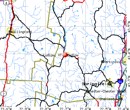
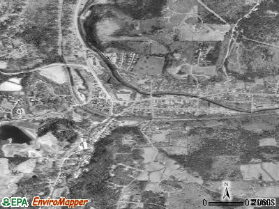
Ludlow, Vermont

Ludlow: Early Morning Cast
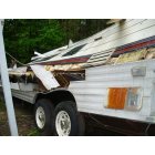
Ludlow: This is what could happen to you after 4 months of trusting Roby and Roby roofing! I could have died and he does not care!! There are now cameras on my property, Why don't you let others companies in so this place won't be a ghost town.With 2,000 people though I am sure they want this slime out and running so others will get them. Don't hire Roby and Roby roofing. This could be you after 4 months.
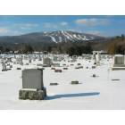
Ludlow: Town Cemetery and view of Okemo
- add
your
Submit your own pictures of this village and show them to the world
- OSM Map
- General Map
- Google Map
- MSN Map
Population change since 2000: -17.8%
| Males: 357 | |
| Females: 430 |
| Median resident age: | 48.4 years |
| Vermont median age: | 43.2 years |
Zip codes: 05149.
| Ludlow: | $48,398 |
| VT: | $73,991 |
Estimated per capita income in 2022: $44,218 (it was $19,824 in 2000)
Ludlow village income, earnings, and wages data
Estimated median house or condo value in 2022: $266,780 (it was $108,800 in 2000)
| Ludlow: | $266,780 |
| VT: | $304,700 |
Mean prices in 2022: all housing units: $346,964; detached houses: $316,780; townhouses or other attached units: $633,292; in 2-unit structures: $266,524; mobile homes: $468,028
Median gross rent in 2022: $953.
(12.5% for White Non-Hispanic residents, 13.0% for two or more races residents)
Detailed information about poverty and poor residents in Ludlow, VT
Compare current foreclosures near Ludlow, VT:
| Photo | Address | Area | Beds / Baths | Price | Details |
|---|---|---|---|---|---|

|
#1
Main St # 1a
Ludlow, VT 05149
|
- sq. feet
|
- baths - beds |
show details | |

|
#2
Doe Hill Way
Woodstock, VT 05091
|
1,264 sq. feet
|
1 baths 1 beds |
$262,900
|
show details |

|
#3
Dillon Rd
Ludlow, VT 05149
|
- sq. feet
|
- baths - beds |
show details | |

|
#4
Dutton District Rd
Springfield, VT 05156
|
1,770 sq. feet
|
1 baths 3 beds |
show details | |

|
#5
James St
Charlestown, NH 03603
|
1,032 sq. feet
|
2 baths 2 beds |
show details | |

|
#6
N Puckerbrush Rd
Reading, VT 05062
|
- sq. feet
|
- baths - beds |
show details | |

|
#7
Westview Ter
Springfield, VT 05156
|
- sq. feet
|
- baths - beds |
show details | |

|
#8
Dogwood Ln
Springfield, VT 05156
|
- sq. feet
|
- baths - beds |
show details | |

|
#9
Roberts Rd
Springfield, VT 05156
|
- sq. feet
|
- baths - beds |
show details | |

|
#10
Bavier Ave
Windsor, VT 05089
|
- sq. feet
|
- baths - beds |
show details |
| Photo | Address | Area | Beds / Baths | Price | Details |
|---|---|---|---|---|---|

|
#11
Sawyer Hill Rd
Mount Holly, VT 05758
|
- sq. feet
|
- baths - beds |
show details | |

|
#12
Mill St
Cavendish, VT 05142
|
- sq. feet
|
- baths - beds |
show details | |

|
#13
Upper Falls Rd
Perkinsville, VT 05151
|
- sq. feet
|
- baths - beds |
show details | |

|
#14
Taylor Dr
Springfield, VT 05156
|
- sq. feet
|
- baths - beds |
show details | |

|
#15
Knipes Dr
North Clarendon, VT 05759
|
- sq. feet
|
- baths - beds |
show details | |

|
Check over 1 million property listings on Foreclosure.com!
|
browse all offers | |||


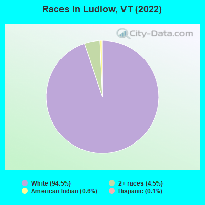
- 67594.5%White alone
- 324.5%Two or more races
- 40.6%American Indian alone
- 10.1%Hispanic
Races in Ludlow detailed stats: ancestries, foreign born residents, place of birth
According to our research of Vermont and other state lists, there were 3 registered sex offenders living in Ludlow, Vermont as of April 26, 2024.
The ratio of all residents to sex offenders in Ludlow is 293 to 1.
Type |
2009 |
2010 |
2011 |
2012 |
2013 |
2014 |
2015 |
2016 |
2017 |
2018 |
2019 |
2020 |
2021 |
2022 |
|---|---|---|---|---|---|---|---|---|---|---|---|---|---|---|
| Murders (per 100,000) | 0 (0.0) | 0 (0.0) | 0 (0.0) | 0 (0.0) | 0 (0.0) | 0 (0.0) | 0 (0.0) | 0 (0.0) | 0 (0.0) | 0 (0.0) | 0 (0.0) | 0 (0.0) | 0 (0.0) | 0 (0.0) |
| Rapes (per 100,000) | 0 (0.0) | 0 (0.0) | 0 (0.0) | 0 (0.0) | 0 (0.0) | 0 (0.0) | 1 (51.8) | 1 (52.0) | 1 (52.8) | 1 (53.5) | 0 (0.0) | 0 (0.0) | 0 (0.0) | 0 (0.0) |
| Robberies (per 100,000) | 1 (37.6) | 0 (0.0) | 0 (0.0) | 0 (0.0) | 0 (0.0) | 0 (0.0) | 4 (207.4) | 0 (0.0) | 3 (158.4) | 0 (0.0) | 1 (53.3) | 0 (0.0) | 0 (0.0) | 0 (0.0) |
| Assaults (per 100,000) | 0 (0.0) | 0 (0.0) | 1 (50.9) | 0 (0.0) | 0 (0.0) | 0 (0.0) | 2 (103.7) | 0 (0.0) | 2 (105.6) | 3 (160.4) | 6 (319.8) | 4 (215.7) | 4 (216.7) | 3 (136.1) |
| Burglaries (per 100,000) | 17 (639.3) | 7 (356.6) | 1 (50.9) | 12 (611.6) | 5 (257.7) | 6 (310.6) | 6 (311.0) | 7 (364.0) | 2 (105.6) | 1 (53.5) | 2 (106.6) | 1 (53.9) | 3 (162.5) | 1 (45.4) |
| Thefts (per 100,000) | 57 (2,144) | 29 (1,477) | 17 (865.1) | 24 (1,223) | 29 (1,495) | 11 (569.4) | 15 (777.6) | 18 (936.0) | 15 (792.0) | 11 (588.2) | 11 (586.4) | 8 (431.5) | 22 (1,192) | 29 (1,316) |
| Auto thefts (per 100,000) | 0 (0.0) | 0 (0.0) | 0 (0.0) | 0 (0.0) | 2 (103.1) | 2 (103.5) | 3 (155.5) | 0 (0.0) | 0 (0.0) | 0 (0.0) | 0 (0.0) | 0 (0.0) | 0 (0.0) | 0 (0.0) |
| Arson (per 100,000) | 0 (0.0) | 0 (0.0) | 0 (0.0) | 0 (0.0) | 0 (0.0) | 0 (0.0) | 0 (0.0) | 0 (0.0) | 0 (0.0) | 0 (0.0) | 0 (0.0) | 0 (0.0) | 0 (0.0) | 0 (0.0) |
| City-Data.com crime index | 141.8 | 84.1 | 48.3 | 91.7 | 86.1 | 52.8 | 189.7 | 104.5 | 149.9 | 102.1 | 110.9 | 64.2 | 102.4 | 83.0 |
The City-Data.com crime index weighs serious crimes and violent crimes more heavily. Higher means more crime, U.S. average is 246.1. It adjusts for the number of visitors and daily workers commuting into cities.
Crime rate in Ludlow detailed stats: murders, rapes, robberies, assaults, burglaries, thefts, arson
Full-time law enforcement employees in 2021, including police officers: 9 (5 officers - 4 male; 1 female).
| Officers per 1,000 residents here: | 2.71 |
| Vermont average: | 1.69 |
 Recent articles from our blog. Our writers, many of them Ph.D. graduates or candidates, create easy-to-read articles on a wide variety of topics.

 | Snow In Vermont (17 replies) |
| Southern Vermont Retirement Advice! Thank you! (22 replies) |
| Commuting from Halifax to Putney (2 replies) |
| Best city in Vermont (35 replies) |
| Another 'Where Should I Live in Vermont' Post (11 replies) |
| Relocating for job in Springfield -- need school advice (19 replies) |
Latest news from Ludlow, VT collected exclusively by city-data.com from local newspapers, TV, and radio stations
Ancestries: English (19.5%), American (11.2%), German (8.3%), Irish (6.1%), French (4.7%), Ukrainian (4.0%).
Current Local Time: EST time zone
Incorporated in 1867
Elevation: 1067 feet
Land area: 1.35 square miles.
Population density: 581 people per square mile (low).
33 residents are foreign born (3.4% Europe, 1.0% North America).
| This village: | 4.6% |
| Vermont: | 4.4% |
Median real estate property taxes paid for housing units with mortgages in 2022: $4,904 (1.6%)
Median real estate property taxes paid for housing units with no mortgage in 2022: $3,814 (1.5%)
Nearest city with pop. 50,000+: Manchester, NH  (69.1 miles , pop. 107,006).
Nearest city with pop. 200,000+: Boston, MA (110.5 miles , pop. 589,141).
Nearest city with pop. 1,000,000+: Bronx, NY (186.2 miles , pop. 1,332,650).
Nearest cities:
), ), ), ), )Latitude: 43.40 N, Longitude: 72.70 W
Area code: 802
Ludlow tourist attractions:
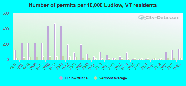
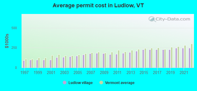
Single-family new house construction building permits:
- 2022: 13 buildings, average cost: $248,200
- 2021: 12 buildings, average cost: $248,200
- 2020: 10 buildings, average cost: $248,200
- 2019: 1 building, cost: $226,800
- 2018: 1 building, cost: $226,800
- 2017: 1 building, cost: $226,800
- 2016: 1 building, cost: $226,800
- 2015: 1 building, cost: $226,800
- 2014: 9 buildings, average cost: $209,200
- 2013: 4 buildings, average cost: $193,300
- 2012: 2 buildings, average cost: $184,000
- 2011: 6 buildings, average cost: $172,800
- 2010: 10 buildings, average cost: $165,900
- 2009: 4 buildings, average cost: $178,900
- 2008: 7 buildings, average cost: $182,400
- 2007: 19 buildings, average cost: $181,200
- 2006: 9 buildings, average cost: $164,100
- 2005: 19 buildings, average cost: $149,000
- 2004: 42 buildings, average cost: $139,600
- 2003: 45 buildings, average cost: $132,800
- 2002: 42 buildings, average cost: $130,700
- 2001: 21 buildings, average cost: $98,000
- 2000: 21 buildings, average cost: $98,000
- 1999: 21 buildings, average cost: $97,800
- 1998: 21 buildings, average cost: $98,800
- 1997: 12 buildings, average cost: $91,700
| Here: | 1.9% |
| Vermont: | 2.0% |
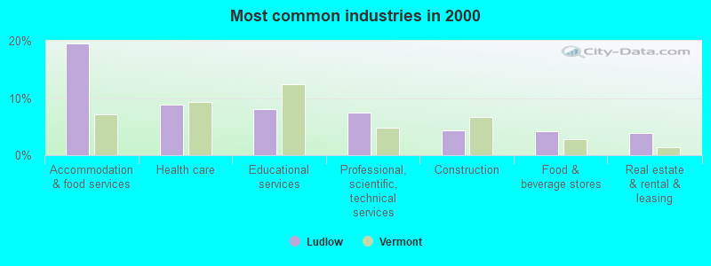
- Accommodation & food services (19.6%)
- Health care (8.9%)
- Educational services (8.0%)
- Professional, scientific, technical services (7.4%)
- Construction (4.3%)
- Food & beverage stores (4.1%)
- Real estate & rental & leasing (3.9%)
- Accommodation & food services (17.7%)
- Professional, scientific, technical services (8.2%)
- Construction (7.8%)
- Transportation equipment (6.5%)
- Health care (6.1%)
- Miscellaneous manufacturing (4.3%)
- Sporting goods, camera, hobby & toy stores (4.3%)
- Accommodation & food services (21.4%)
- Educational services (14.0%)
- Health care (11.8%)
- Professional, scientific, technical services (6.6%)
- Food & beverage stores (5.2%)
- Textile mills & textile products (4.8%)
- Real estate & rental & leasing (4.8%)
- Other management occupations, except farmers and farm managers (6.7%)
- Retail sales workers, except cashiers (5.4%)
- Other sales and related occupations, including supervisors (4.6%)
- Preschool, kindergarten, elementary, and middle school teachers (4.3%)
- Metal workers and plastic workers (4.3%)
- Information and record clerks, except customer service representatives (4.3%)
- Waiters and waitresses (4.1%)
- Metal workers and plastic workers (8.7%)
- Other management occupations, except farmers and farm managers (6.9%)
- Retail sales workers, except cashiers (6.9%)
- Other production occupations, including supervisors (6.1%)
- Driver/sales workers and truck drivers (4.8%)
- Other sales and related occupations, including supervisors (4.3%)
- Engineers (3.5%)
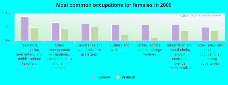
- Preschool, kindergarten, elementary, and middle school teachers (8.7%)
- Other management occupations, except farmers and farm managers (6.6%)
- Secretaries and administrative assistants (6.1%)
- Waiters and waitresses (5.7%)
- Textile, apparel, and furnishings workers (5.7%)
- Information and record clerks, except customer service representatives (5.7%)
- Other sales and related occupations, including supervisors (4.8%)
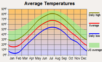
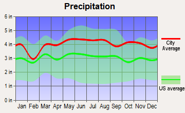
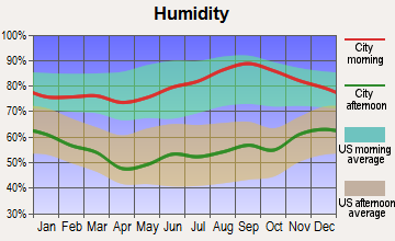
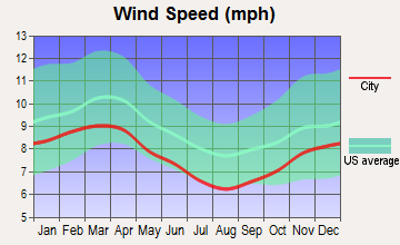
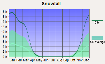
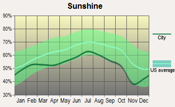
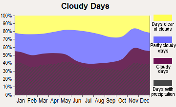
Average climate in Ludlow, Vermont
Based on data reported by over 4,000 weather stations
(lower is better)
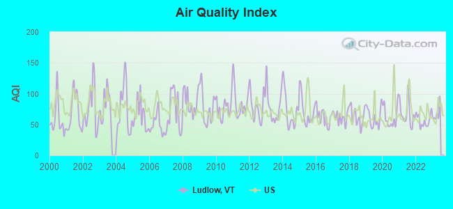
Air Quality Index (AQI) level in 2022 was 56.9. This is better than average.
| City: | 56.9 |
| U.S.: | 72.6 |
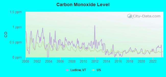
Carbon Monoxide (CO) [ppm] level in 2022 was 0.251. This is about average. Closest monitor was 20.4 miles away from the city center.
| City: | 0.251 |
| U.S.: | 0.251 |
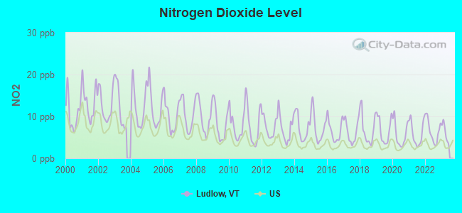
Nitrogen Dioxide (NO2) [ppb] level in 2022 was 6.51. This is worse than average. Closest monitor was 20.4 miles away from the city center.
| City: | 6.51 |
| U.S.: | 5.11 |
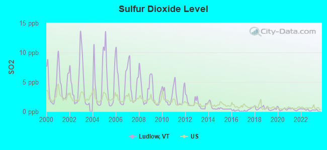
Sulfur Dioxide (SO2) [ppb] level in 2022 was 0.299. This is significantly better than average. Closest monitor was 13.5 miles away from the city center.
| City: | 0.299 |
| U.S.: | 1.515 |

Ozone [ppb] level in 2022 was 23.5. This is significantly better than average. Closest monitor was 16.6 miles away from the city center.
| City: | 23.5 |
| U.S.: | 33.3 |
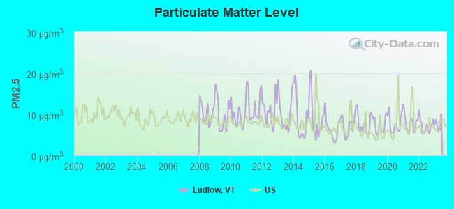
Particulate Matter (PM2.5) [µg/m3] level in 2022 was 7.23. This is about average. Closest monitor was 18.4 miles away from the city center.
| City: | 7.23 |
| U.S.: | 8.11 |
Tornado activity:
Ludlow-area historical tornado activity is above Vermont state average. It is 57% smaller than the overall U.S. average.
On 8/20/1968, a category F3 (max. wind speeds 158-206 mph) tornado 21.0 miles away from the Ludlow village center injured one person and caused between $5000 and $50,000 in damages.
On 7/9/1962, a category F2 (max. wind speeds 113-157 mph) tornado 8.4 miles away from the village center caused between $5000 and $50,000 in damages.
Earthquake activity:
Ludlow-area historical earthquake activity is significantly above Vermont state average. It is 70% smaller than the overall U.S. average.On 10/7/1983 at 10:18:46, a magnitude 5.3 (5.1 MB, 5.3 LG, 5.1 ML, Class: Moderate, Intensity: VI - VII) earthquake occurred 90.7 miles away from Ludlow center
On 4/20/2002 at 10:50:47, a magnitude 5.3 (5.3 ML, Depth: 3.0 mi) earthquake occurred 91.8 miles away from the city center
On 4/20/2002 at 10:50:47, a magnitude 5.2 (5.2 MB, 4.2 MS, 5.2 MW, 5.0 MW) earthquake occurred 90.9 miles away from the city center
On 1/19/1982 at 00:14:42, a magnitude 4.7 (4.5 MB, 4.7 MD, 4.5 LG, Class: Light, Intensity: IV - V) earthquake occurred 55.8 miles away from Ludlow center
On 10/16/2012 at 23:12:25, a magnitude 4.7 (4.7 ML, Depth: 10.0 mi) earthquake occurred 103.6 miles away from the city center
On 6/17/1991 at 08:53:16, a magnitude 4.1 (4.0 MB, 4.0 LG, Depth: 3.1 mi) earthquake occurred 113.1 miles away from the city center
Magnitude types: regional Lg-wave magnitude (LG), body-wave magnitude (MB), duration magnitude (MD), local magnitude (ML), surface-wave magnitude (MS), moment magnitude (MW)
Natural disasters:
The number of natural disasters in Windsor County (20) is greater than the US average (15).Major Disasters (Presidential) Declared: 16
Emergencies Declared: 2
Causes of natural disasters: Floods: 14, Storms: 13, Tropical Storms: 2, Heavy Rain: 1, Hurricane: 1, Ice Storm: 1, Landslide: 1, Snowstorm: 1, Wind: 1, Winter Storm: 1 (Note: some incidents may be assigned to more than one category).

Hospitals and medical centers in Ludlow:
Airports located in Ludlow:
- Smith Airport (VT17) (Runways: 1)
Colleges/universities with over 2000 students nearest to Ludlow:
- Castleton State College (about 29 miles; Castleton, VT; Full-time enrollment: 2,079)
- Dartmouth College (about 30 miles; Hanover, NH; FT enrollment: 6,030)
- Keene State College (about 39 miles; Keene, NH; FT enrollment: 5,098)
- Adirondack Community College (about 48 miles; Queensbury, NY; FT enrollment: 2,826)
- Middlebury College (about 49 miles; Middlebury, VT; FT enrollment: 3,077)
- Norwich University (about 52 miles; Northfield, VT; FT enrollment: 4,221)
- Franklin Pierce University (about 54 miles; Rindge, NH; FT enrollment: 2,139)
Public high school in Ludlow:
- BLACK RIVER USD #39 (Students: 235, Location: 43 MAIN STREET, Grades: 7-12)
Private high school in Ludlow:
Public elementary/middle school in Ludlow:
- LUDLOW ELEMENTARY SCHOOL (Students: 119, Location: 45 MAIN STREET, Grades: PK-6)
Libraries in Ludlow:
- FLETCHER MEMORIAL (Operating income: $156,149; Location: 88 MAIN ST.; 11,694 books; 759 audio materials; 231 video materials; 1 local licensed databases; 19 state licensed databases; 78 print serial subscriptions)
- TYSON (Operating income: $250; Location: 286 DUBLIN RD.; 3,525 books; 46 audio materials; 23 video materials; 10 print serial subscriptions)
User-submitted facts and corrections:
- WNTK radio station (Newport, N.H. ) is incorrectly listed as 1020 am. It is actually 1010 on the dial.
Points of interest:
Notable locations in Ludlow: Ludlow Town Hall (A), Ludlow Chamber of Commerce (B), Fletcher Memorial Library (C), Black River Academy Museum (D), Ludlow Fire Department (E), Ludlow Ambulance Service (F). Display/hide their locations on the map
Shopping Center: Ludlow Shopping Plaza Shopping Center (1). Display/hide its location on the map
Churches in Ludlow include: United Church of Ludlow (A), Church of the Annunciation (B), Ludlow Baptist Church (C). Display/hide their locations on the map
Cemetery: Pleasant View Cemetery (1). Display/hide its location on the map
Streams, rivers, and creeks: Jewell Brook (A). Display/hide its location on the map
Park in Ludlow: Dorsey Park (1). Display/hide its location on the map
Hotels: Timber Inn Motel (112 Route 103 South), Governor's Inn (Main Street), All Seasons Motel (112 Main Street), Trojan Horse Lodge (44 Andover Street), Happy Trails Motel (321 Route 103 South), Combes Family Inn (953 East Lake Road), Best Western Ludlow Colonial (93 Main Street), Jackson Gore Inn (111 Jackson Gore Road).
Birthplace of: Alanson W. Beard - Politician.
Drinking water stations with addresses in Ludlow and their reported violations in the past:
OKEMO MOUNTAIN INC (Address: 77 OKEMO RIDGE RD , Population served: 3,000, Groundwater):Past health violations:JACKSON GORE OKEMO (Address: 77 OKEMO RIDGE RD , Population served: 1,695, Groundwater):Past monitoring violations:
- MCL, Monthly (TCR) - In JAN-2008, Contaminant: Coliform. Follow-up actions: St Boil Water Order (JAN-15-2008), St Formal NOV issued (JAN-15-2008), St Tech Assistance Visit (JAN-15-2008), St Public Notif requested (JAN-15-2008), St Public Notif received (JAN-17-2008), St Compliance achieved (SEP-25-2009)
- One minor monitoring violation
Past monitoring violations:OKEMO SUMMIT LODGE (Address: 77 OKEMO RIDGE RD , Population served: 1,000, Groundwater):
- Follow-up Or Routine LCR Tap M/R - In OCT-01-2006, Contaminant: Lead and Copper Rule. Follow-up actions: St Public Notif requested (DEC-04-2006), St Formal NOV issued (DEC-04-2006), St Public Notif received (MAY-23-2008), St Compliance achieved (MAR-17-2011)
Past monitoring violations:OKEMO SOLITUDE (Address: 77 OKEMO RIDGE RD , Population served: 976, Groundwater):
- One routine major monitoring violation
- One minor monitoring violation
Past monitoring violations:WINTERPLACE WATER SYSTEM (Population served: 700, Groundwater):
- Follow-up Or Routine LCR Tap M/R - In OCT-01-2006, Contaminant: Lead and Copper Rule. Follow-up actions: St Public Notif requested (DEC-04-2006), St Formal NOV issued (DEC-04-2006), St Public Notif received (DEC-18-2006), St Compliance achieved (JAN-04-2011)
Past health violations:OKEMO TRAILSIDE CONDOMINIUM (Population served: 540, Groundwater):Past monitoring violations:
- MCL, Monthly (TCR) - In OCT-2006, Contaminant: Coliform. Follow-up actions: St Tech Assistance Visit (OCT-16-2006), St Boil Water Order (OCT-16-2006), St Public Notif requested (OCT-16-2006), St Formal NOV issued (OCT-16-2006), St Compliance achieved (OCT-24-2006)
- Monitoring and Reporting (DBP) - Between APR-2009 and JUN-2009, Contaminant: Chlorine. Follow-up actions: St Public Notif requested (SEP-01-2009), St Formal NOV issued (SEP-01-2009), St Public Notif received (JUN-15-2010), St Compliance achieved (APR-27-2011)
- Monitoring and Reporting (DBP) - Between JUL-2008 and SEP-2008, Contaminant: Chlorine. Follow-up actions: St Public Notif requested (APR-07-2009), St Formal NOV issued (APR-07-2009), St Public Notif received (AUG-13-2009), St Compliance achieved (APR-27-2011)
- Monitoring and Reporting (DBP) - Between APR-2008 and JUN-2008, Contaminant: Chlorine. Follow-up actions: St Public Notif requested (JAN-15-2009), St Formal NOV issued (JAN-15-2009), St Public Notif received (AUG-13-2009), St Compliance achieved (APR-27-2011)
- 3 routine major monitoring violations
- One regular monitoring violation
Past health violations:OKEMO VALLEY GOLF CLUB (Address: 77 OKEMO RIDGE RD , Population served: 195, Groundwater):Past monitoring violations:
- OCCT/SOWT Study/Recommendation - In APR-01-2007, Contaminant: Lead and Copper Rule. Follow-up actions: St Compliance achieved (FEB-03-2011)
- Initial, Follow-up, or Routine Source Water M/R - In APR-01-2007, Contaminant: Lead and Copper Rule. Follow-up actions: St Compliance achieved (FEB-03-2011)
- Water Quality Parameter M/R - Between JAN-2006 and DEC-2006, Contaminant: Lead and Copper Rule. Follow-up actions: St Public Notif requested (MAY-09-2007), St Formal NOV issued (MAY-09-2007), St Public Notif received (JUN-30-2008), St Compliance achieved (FEB-03-2011)
- One routine major monitoring violation
- One minor monitoring violation
- 24 regular monitoring violations
Past health violations:ALPEN MEADOWS (Address: 272 WEST HILL RD , Population served: 112, Groundwater):
- MCL, Monthly (TCR) - In AUG-2005, Contaminant: Coliform. Follow-up actions: St Violation/Reminder Notice (AUG-04-2005), St Boil Water Order (AUG-04-2005), St Tech Assistance Visit (AUG-04-2005), St Public Notif requested (AUG-04-2005), St Compliance achieved (JAN-29-2010)
Past health violations:Past monitoring violations:
- MCL, Monthly (TCR) - In JUN-2011, Contaminant: Coliform. Follow-up actions: St Tech Assistance Visit (JUN-16-2011), St Formal NOV issued (JUN-16-2011), St Public Notif requested (JUN-16-2011), St Boil Water Order (JUN-16-2011), St Compliance achieved (JUL-07-2011)
- Monitoring and Reporting (DBP) - Between OCT-2013 and DEC-2013, Contaminant: Chlorine. Follow-up actions: St Public Notif requested (DEC-26-2013), St Formal NOV issued (DEC-26-2013), St Public Notif received (JUN-16-2014)
- Monitoring and Reporting (DBP) - Between OCT-2013 and DEC-2013, Contaminant: Chlorine. Follow-up actions: St Formal NOV issued (JAN-21-2014), St Public Notif requested (JAN-21-2014)
- Monitoring, Repeat Major (TCR) - In NOV-2009, Contaminant: Coliform (TCR). Follow-up actions: St Formal NOV issued (FEB-04-2010), St Public Notif requested (FEB-04-2010), St Public Notif received (JUN-11-2010), St Compliance achieved (NOV-18-2010)
- Monitoring and Reporting (DBP) - Between OCT-2009 and DEC-2009, Contaminant: Chlorine. Follow-up actions: St Public Notif requested (MAR-01-2010), St Formal NOV issued (MAR-01-2010), St Public Notif received (JUN-11-2010), St Compliance achieved (FEB-15-2011)
- Monitoring and Reporting (DBP) - Between APR-2008 and JUN-2008, Contaminant: Chlorine. Follow-up actions: St Public Notif requested (JAN-15-2009), St Formal NOV issued (JAN-15-2009), St Public Notif received (JUN-26-2009), St Compliance achieved (FEB-15-2011)
- 2 minor monitoring violations
- 2 other older monitoring violations
Drinking water stations with addresses in Ludlow that have no violations reported:
- LUDLOW VILLAGE WATER DEPT (Population served: 2,818, Primary Water Source Type: Groundwater)
- BULL RUN (Address: 77 OKEMO RIDGE RD , Population served: 420, Primary Water Source Type: Groundwater)
- TATER HILL CLUBHOUSE RESTAURANT (Address: 77 OKEMO RIDGE RD , Population served: 104, Primary Water Source Type: Groundwater)
- OKEMO INN (Address: 61 LOCUST HILL RD , Population served: 85, Primary Water Source Type: Groundwater)
- WEST HILL RECREATION (Population served: 50, Primary Water Source Type: Groundwater)
| This village: | 1.9 people |
| Vermont: | 2.3 people |
| This village: | 43.0% |
| Whole state: | 62.5% |
| This village: | 7.2% |
| Whole state: | 9.2% |
Likely homosexual households (counted as self-reported same-sex unmarried-partner households)
- Lesbian couples: 0.2% of all households
- Gay men: 0.2% of all households
People in group quarters in Ludlow in 2010:
- 44 people in nursing facilities/skilled-nursing facilities
- 4 people in emergency and transitional shelters (with sleeping facilities) for people experiencing homelessness
- 3 people in group homes for juveniles (non-correctional)
2 people in other noninstitutional group quarters in 2000
Banks with branches in Ludlow (2011 data):
- People's United Bank: Vermont Branch at 213 Main Street, branch established on 1977/12/19. Info updated 2012/02/16: Bank assets: $27,319.3 mil, Deposits: $20,835.4 mil, headquarters in Bridgeport, CT, positive income, Commercial Lending Specialization, 374 total offices
- Berkshire Bank: Ludlow Branch at 152 Main Street, branch established on 1967/01/16. Info updated 2011/08/24: Bank assets: $3,955.6 mil, Deposits: $3,176.2 mil, headquarters in Pittsfield, MA, positive income, Commercial Lending Specialization, 64 total offices
For population 15 years and over in Ludlow:
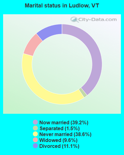
- Never married: 38.6%
- Now married: 39.2%
- Separated: 1.5%
- Widowed: 9.6%
- Divorced: 11.1%
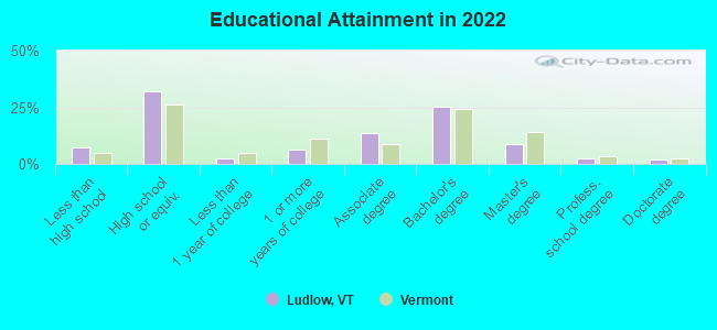
For population 25 years and over in Ludlow:
- High school or higher: 89.7%
- Bachelor's degree or higher: 35.5%
- Graduate or professional degree: 11.5%
- Unemployed: 5.3%
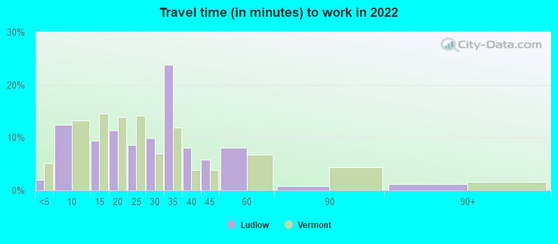
- Mean travel time to work (commute): 17.6 minutes
| Here: | 12.2 |
| Vermont average: | 10.8 |
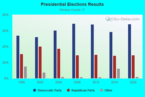
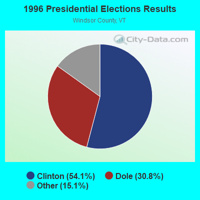
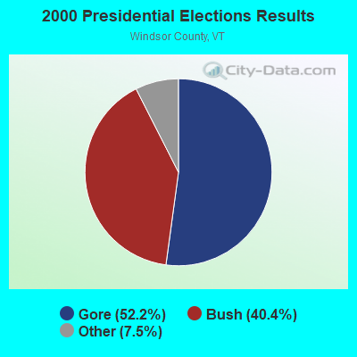
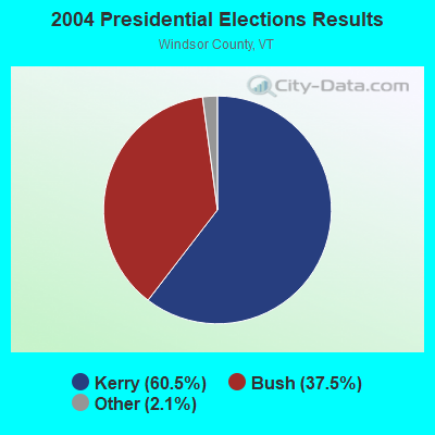
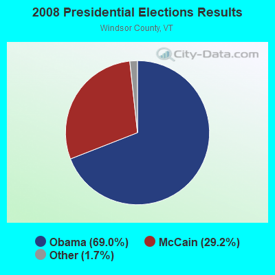
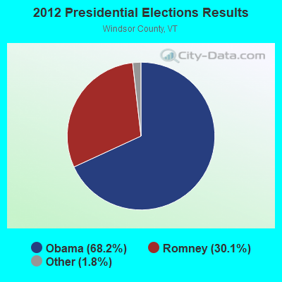
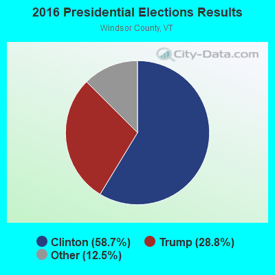
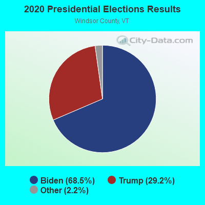
Graphs represent county-level data. Detailed 2008 Election Results
Religion statistics for Ludlow, VT (based on Windsor County data)
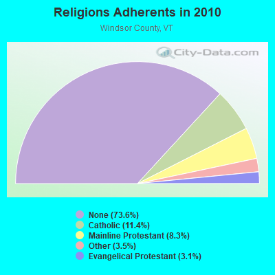
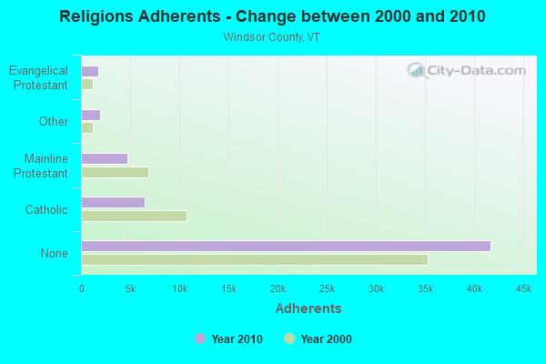
| Religion | Adherents | Congregations |
|---|---|---|
| Catholic | 6,485 | 10 |
| Mainline Protestant | 4,700 | 45 |
| Other | 1,964 | 17 |
| Evangelical Protestant | 1,750 | 21 |
| Orthodox | 55 | 1 |
| None | 41,716 | - |
Food Environment Statistics:
| Windsor County: | 4.93 / 10,000 pop. |
| Vermont: | 3.84 / 10,000 pop. |
| Here: | 1.23 / 10,000 pop. |
| Vermont: | 1.95 / 10,000 pop. |
| Windsor County: | 7.93 / 10,000 pop. |
| Vermont: | 6.40 / 10,000 pop. |
| Windsor County: | 14.97 / 10,000 pop. |
| State: | 11.52 / 10,000 pop. |
| Here: | 7.1% |
| State: | 6.8% |
| Windsor County: | 22.8% |
| Vermont: | 22.3% |
| Windsor County: | 9.7% |
| Vermont: | 13.3% |
Health and Nutrition:
| Here: | 63.7% |
| Vermont: | 52.9% |
| This city: | 66.5% |
| Vermont: | 51.9% |
| This city: | 27.1 |
| State: | 28.4 |
| Here: | 16.0% |
| Vermont: | 21.2% |
| This city: | 5.1% |
| Vermont: | 8.8% |
| Ludlow: | 7.2 |
| Vermont: | 6.9 |
| Ludlow: | 32.6% |
| State: | 34.9% |
| Ludlow: | 69.2% |
| State: | 59.7% |
| Here: | 83.0% |
| State: | 79.6% |
More about Health and Nutrition of Ludlow, VT Residents
| Local government employment and payroll (March 2022) | |||||
| Function | Full-time employees | Monthly full-time payroll | Average yearly full-time wage | Part-time employees | Monthly part-time payroll |
|---|---|---|---|---|---|
| Electric Power | 11 | $79,069 | $86,257 | 0 | $0 |
| Streets and Highways | 6 | $7,551 | $15,102 | 0 | $0 |
| Sewerage | 3 | $6,517 | $26,068 | 0 | $0 |
| Financial Administration | 0 | $0 | 1 | $607 | |
| Water Supply | 0 | $0 | 3 | $7,737 | |
| Other Government Administration | 0 | $0 | 4 | $6,687 | |
| Totals for Government | 20 | $93,137 | $55,882 | 8 | $15,031 |
Ludlow government finances - Expenditure in 2018 (per resident):
- Construction - Electric Utilities: $362,000 ($459.97)
- Current Operations - Electric Utilities: $5,657,000 ($7188.06)
Regular Highways: $299,000 ($379.92)
General - Other: $117,000 ($148.67)
Central Staff Services: $116,000 ($147.40)
- Electric Utilities - Interest on Debt: $5,000 ($6.35)
- General - Interest on Debt: $54,000 ($68.61)
- Intergovernmental to Local - Other - Regular Highways: $40,000 ($50.83)
Other - Electric Utilities: $24,000 ($30.50)
- Intergovernmental to State - Electric Utilities: $37,000 ($47.01)
- Total Salaries and Wages: $203,000 ($257.94)
Ludlow government finances - Revenue in 2018 (per resident):
- Charges - Other: $3,000 ($3.81)
- Local Intergovernmental - Highways: $40,000 ($50.83)
- Miscellaneous - General Revenue - Other: $238,000 ($302.41)
Interest Earnings: $42,000 ($53.37)
- Revenue - Electric Utilities: $6,830,000 ($8678.53)
- State Intergovernmental - Highways: $4,000 ($5.08)
- Tax - Property: $361,000 ($458.70)
Ludlow government finances - Debt in 2018 (per resident):
- Long Term Debt - Beginning Outstanding - Unspecified Public Purpose: $2,603,000 ($3307.50)
Outstanding Unspecified Public Purpose: $2,493,000 ($3167.73)
Retired Unspecified Public Purpose: $110,000 ($139.77)
- Short Term Debt Outstanding - Beginning: $205,000 ($260.48)
End of Fiscal Year: $171,000 ($217.28)
Ludlow government finances - Cash and Securities in 2018 (per resident):
- Bond Funds - Cash and Securities: $1,083,000 ($1376.11)
- Other Funds - Cash and Securities: $4,481,000 ($5693.77)
- Sinking Funds - Cash and Securities: $250,000 ($317.66)
| Businesses in Ludlow, VT | ||||
| Name | Count | Name | Count | |
|---|---|---|---|---|
| Best Western | 1 | Rite Aid | 1 | |
| Chevrolet | 1 | Shaw's | 1 | |
| Dunkin Donuts | 1 | Subway | 1 | |
| FedEx | 1 | UPS | 1 | |
Strongest AM radio stations in Ludlow:
- WNBX (1480 AM; 5 kW; SPRINGFIELD, VT)
- WNTK (1020 AM; 10 kW; NEWPORT, NH; Owner: KOOR COMMUNICATIONS, INC.)
- WNNZ (640 AM; 50 kW; WESTFIELD, MA; Owner: CLEAR CHANNEL BROADCASTING LICENSES, INC.)
- WGY (810 AM; 50 kW; SCHENECTADY, NY; Owner: CLEAR CHANNEL BROADCASTING LICENSES, INC.)
- WSYB (1380 AM; 5 kW; RUTLAND, VT; Owner: CAPSTAR TX LIMITED PARTNERSHIP)
- WCRN (830 AM; 50 kW; WORCESTER, MA; Owner: CARTER BROADCASTING CORPORATION)
- WRKO (680 AM; 50 kW; BOSTON, MA; Owner: ENTERCOM BOSTON LICENSE, LLC)
- WPTR (1540 AM; 50 kW; ALBANY, NY; Owner: KIMTRON, INC.)
- WEEI (850 AM; 50 kW; BOSTON, MA; Owner: ENTERCOM BOSTON LICENSE, LLC)
- WVNE (760 AM; daytime; 25 kW; LEICESTER, MA; Owner: BLOUNT MASSCOM, INC.)
- WKOX (1200 AM; 50 kW; FRAMINGHAM, MA; Owner: CAPSTAR TX LIMITED PARTNERSHIP)
- WALE (990 AM; 50 kW; GREENVILLE, RI; Owner: NORTH AMERICAN BROADCASTING CO., INC.)
- WBIX (1060 AM; 40 kW; NATICK, MA; Owner: LANGER BROADCASTING CORPORATION)
Strongest FM radio stations in Ludlow:
- WVPR (89.5 FM; WINDSOR, VT; Owner: VERMONT PUBLIC RADIO)
- WJJR (98.1 FM; RUTLAND, VT; Owner: 6 JOHNSON ROAD LICENSES, INC.)
- WZRT (97.1 FM; RUTLAND, VT; Owner: CAPSTAR TX LIMITED PARTNERSHIP)
- WEBK (105.3 FM; KILLINGTON, VT; Owner: 6 JOHNSON ROAD LICENSES, INC.)
- WGLV (91.7 FM; WOODSTOCK, VT; Owner: CHRISTIAN MINISTRIES INC)
- WHDQ-FM1 (106.1 FM; RUTLAND, VT; Owner: GREAT NORTHERN RADIO, L.L.C.)
- WHDQ (106.1 FM; CLAREMONT, NH; Owner: GREAT NORTHERN RADIO, L.L.C.)
- WEQX (102.7 FM; MANCHESTER, VT; Owner: NORTHSHIRE COMMUNICATIONS, INC.)
- WJAN (95.1 FM; SUNDERLAND, VT; Owner: 6 JOHNSON ROAD LICENSES, INC.)
- WVRR (101.7 FM; NEWPORT, NH; Owner: CAPSTAR TX LIMITED PARTNERSHIP)
- W220AX (91.9 FM; LUDLOW, VT; Owner: CHRISTIAN RADIO FELLOWSHIP)
- WMXR (93.9 FM; WOODSTOCK, VT; Owner: CLEAR CHANNEL BROADCASTING LICENSES, INC.)
- WXKK (93.5 FM; SPRINGFIELD, VT; Owner: CLEAR CHANNEL BROADCASTING LICENSES, INC.)
- WJEN (94.5 FM; RUTLAND, VT; Owner: 6 JOHNSON ROAD LICENSES, INC.)
- WVAY (100.7 FM; WILMINGTON, VT; Owner: GREAT NORTHERN RADIO, L.L.C.)
- WDEV-FM (96.1 FM; WARREN, VT; Owner: RADIO VERMONT, INC.)
- WEXP (101.5 FM; BRANDON, VT; Owner: VOX VERMONT, L.L.C.)
- WEVH (91.3 FM; HANOVER, NH; Owner: NEW HAMPSHIRE PUBLIC RADIO INC)
- WKNE (103.7 FM; KEENE, NH; Owner: SAGA COMMUNICATIONS OF NEW ENGLAND, LLC)
- WEVN (90.7 FM; KEENE, NH; Owner: NEW HAMPSHIRE PUBLIC RADIO, INC.)
TV broadcast stations around Ludlow:
- WVTA (Channel 41; WINDSOR, VT; Owner: VERMONT ETV, INC.)
- WNNE (Channel 31; HARTFORD, VT; Owner: HEARST-ARGYLE STATIONS, INC.)
- W17CI (Channel 17; CLAREMONT, NH; Owner: UPPER VALLEY BROADCASTING, LLC)
- WEKW-TV (Channel 52; KEENE, NH; Owner: UNIVERSITY OF NEW HAMPSHIRE)
- Ludlow, Vermont
- Fatal accident count20
- Vehicles involved in fatal accidents33
- Fatal accidents involving drunk persons:9
- Fatalities23
- Persons involved in fatal accidents49
- Pedestrians involved in fatal accidents1
- Vermont average
- Fatal accident count1447
- Vehicles involved in fatal accidents2019
- Fatal accidents involving drunk persons643
- Fatalities1613
- Persons involved in fatal accidents3672
- Pedestrians involved in fatal accidents60
- National Bridge Inventory (NBI) Statistics
- 20Number of bridges
- 125ft / 37.7mTotal length
- $5,940,000Total costs
- 73,356Total average daily traffic
- 5,651Total average daily truck traffic
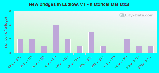
- New bridges - historical statistics
- 21900-1909
- 21910-1919
- 11920-1929
- 41930-1939
- 21940-1949
- 11950-1959
- 31960-1969
- 11970-1979
- 21990-1999
- 12000-2009
- 12010-2019
FCC Registered Cell Phone Towers:
1- Ludlow Cell Site 1.2 Miles West Of Ludlow On Okemo Mt. (Lat: 43.407861 Lon: -72.732611), Structure height: 9.1 m, Call Sign: KNKQ277
Assigned Frequencies: 880.020 MHz, 891.510 MHz, 835.020 MHz, 846.510 MHzGrant Date: 09/08/2021, Expiration Date: 10/01/2031Registrant: Wilkinson Barker Knauer, LLP, 1800 M Street Nw, Suite 800n, Washington, DC 20036, Phone: (202) 383-3420, Fax: (202) 783-5851, Email:
FCC Registered Antenna Towers:
1- Gordon Mathews, 130 Preedom Hill Rd., North (Lat: 43.418972 Lon: -72.684472), Type: 36.5, Structure height: 50027 m, Overall height: 36.5 m, Registrant: Vtel Wireless Inc, Gmathews@vermontel.Com, , Sprin-gfield, Phone: (802) 885-7712
FCC Registered Private Land Mobile Towers:
1- Okemo Hill (Lat: 43.388417 Lon: -72.711194), Structure height: 5 m, Call Sign: WPCH319,
Assigned Frequencies: 152.480 MHz, 464.200 MHz, Grant Date: 05/01/2018, Expiration Date: 05/25/2028, Certifier: Kathy M Paskevich, Registrant: Jkl Communications LLC, 142 Avenue C, Williston, VT 05495, Phone: (802) 860-0000, Fax: (802) 860-5037, Email:
FCC Registered Broadcast Land Mobile Towers:
6- Okemo Mountain - Mid Mountain Tower Site (Lat: 43.408139 Lon: -72.722583), Type: Tower, Structure height: 12 m, Call Sign: KNBL828,
Assigned Frequencies: 155.790 MHz, Grant Date: 07/12/2001, Expiration Date: 09/25/2011, Cancellation Date: 11/26/2011, Registrant: R&r Communications, Inc., 187 Banning Road, Swanzey, NH 03446, Phone: (603) 352-1825, Fax: (603) 352-5697, Email:
- Police Dept Municipal Office (Lat: 43.401472 Lon: -72.746778), Call Sign: KSU651,
Assigned Frequencies: 460.250 MHz, 460.500 MHz, Grant Date: 05/19/2022, Expiration Date: 08/10/2032, Registrant: State Of Vermont, 45 State Drive, Watterbury, VT 05671, Phone: (802) 229-0882, Fax: (802) 241-5615, Email:
- Municipal Office Police Dept (Lat: 43.401472 Lon: -72.746778), Call Sign: WAN505,
Assigned Frequencies: 465.025 MHz, Grant Date: 05/29/2014, Expiration Date: 07/24/2024, Registrant: State Of Vermont, 45 State Drive, Watterbury, VT 05671, Phone: (802) 229-0882, Fax: (802) 241-5557, Email:
- Lat: 43.408139 Lon: -72.722583, Call Sign: WNGW772,
Assigned Frequencies: 154.540 MHz, 151.715 MHz, 151.955 MHz, 151.745 MHz, 151.865 MHz, 151.895 MHz, 151.925 MHz, 154.515 MHz, Grant Date: 06/05/2002, Expiration Date: 06/17/2012, Cancellation Date: 08/18/2012, Registrant: Utility Communications, Inc., 920 Sherman Avenue, Hamden, CT 06514, Phone: (203) 287-1306, Fax: (203) 248-9167, Email:
- Okemo Ridge Road-Pump House 2 (Lat: 43.417861 Lon: -72.711472), Type: Pipe, Structure height: 3 m, Call Sign: WPPS512,
Assigned Frequencies: 463.800 MHz, Grant Date: 02/14/2000, Expiration Date: 02/14/2005, Cancellation Date: 04/16/2005, Certifier: Charles M Fowler, Registrant: Burlington Communications Service C, 43 Birchcliff Parkway, Burlington, VT 05401, Fax: (802) 860-6178
- Lat: 43.385361 Lon: -72.667861, Call Sign: WPZZ436,
Assigned Frequencies: 152.900 MHz, 158.385 MHz, Grant Date: 01/20/2024, Expiration Date: 04/14/2034, Certifier: Matthew Fenton, Registrant: Business Radio Licensing, 30251 Golden Lantern, Suite E #501, Laguna Niguel, CA 92677, Phone: (949) 348-8510, Fax: (949) 348-8514, Email:
FCC Registered Microwave Towers:
6- LUDLOW, Okemo Mtn Ski Area (Lat: 43.407583 Lon: -72.733500), Type: Pole, Structure height: 10.7 m, Call Sign: WQKD351,
Assigned Frequencies: 6152.75 MHz, 6152.75 MHz, 6152.75 MHz, 6152.75 MHz, Grant Date: 04/02/2019, Expiration Date: 04/07/2029, Cancellation Date: 03/09/2021, Certifier: John E Rooney, Registrant: Holland & Knight LLP, 800 17th Street, N.W., Suite #1100, Washington, DC 20006-3906, Phone: (202) 955-3000, Fax: (202) 955-5564, Email:
- OKEMO, 77 Okemo Ridge Rd (Lat: 43.407472 Lon: -72.733417), Type: Mtower, Structure height: 24.1 m, Call Sign: WQSV584,
Assigned Frequencies: 10895.0 MHz, 10935.0 MHz, Grant Date: 10/17/2023, Expiration Date: 11/21/2033, Certifier: John Monday, Registrant: At&t Services, Inc., 208 S Akard St, 20f, Dallas, TX 75202, Phone: (855) 699-7073, Email:
- LUDLOW DT, 93 Godfrey Road (Lat: 43.388472 Lon: -72.695722), Type: Ltower, Structure height: 27.4 m, Overall height: 28.3 m, Call Sign: WQSY592,
Assigned Frequencies: 5974.85 MHz, Grant Date: 12/10/2013, Expiration Date: 12/10/2023, Cancellation Date: 10/15/2015, Certifier: Steven A Regitz, Registrant: Verizon Wireless, 1120 Sanctuary Pkwy, #150 Gasa5reg, Alpharetta, GA 30009-7630, Phone: (770) 797-1070, Fax: (770) 797-1036, Email:
- OKEMO MTN, Atop Okemo Mountain (Lat: 43.405000 Lon: -72.750000), Type: Ltower, Structure height: 12.2 m, Call Sign: WQVG709,
Assigned Frequencies: 11405.0 MHz, 6004.50 MHz, 6093.45 MHz, 6004.50 MHz, 6093.45 MHz, 6004.50 MHz, 6093.45 MHz, 6004.50 MHz, 6093.45 MHz, 6004.50 MHz... (+11 more), Grant Date: 02/06/2015, Expiration Date: 02/06/2025, Certifier: Phillip T Chitwood, Registrant: Vermont Transco LLC, 366 Pinnacle Ridge Road, Rutland, VT 05701, Phone: (802) 772-3777, Email:
- NE72XC050, 1775 Mountain Road (Lat: 43.407500 Lon: -72.733417), Type: Mtower, Structure height: 21.6 m, Call Sign: WQWB607,
Assigned Frequencies: 11625.0 MHz, 11625.0 MHz, 11625.0 MHz, 11625.0 MHz, 11625.0 MHz, 11625.0 MHz, 11625.0 MHz, Grant Date: 07/09/2015, Expiration Date: 07/09/2025, Cancellation Date: 05/12/2023, Certifier: David Werblow, Registrant: T-Mobile Usa, Inc., 12920 Se 38th Street, Bellevue, WA 98006, Phone: (425) 383-8401, Email:
- LUDLOW II, Okemo Mtn Ski Area (Lat: 43.407472 Lon: -72.733417), Type: Mtower, Structure height: 24.4 m, Overall height: 25.9 m, Call Sign: WQWP684,
Assigned Frequencies: 6152.75 MHz, 6152.75 MHz, 6152.75 MHz, 6152.75 MHz, Grant Date: 10/20/2015, Expiration Date: 10/20/2025, Certifier: Steven T Campbell, Registrant: Wilkinson Barker Knauer, LLP, 1800 M Street Nw, Suite 800n, Washington, DC 20036, Phone: (202) 383-3420, Fax: (202) 783-5851, Email:
FCC Registered Paging Towers:
1- 1.5 Mi N Of Ludlow On N Hill Rd. (Lat: 43.417917 Lon: -72.685444), Structure height: 15.2 m, Overall height: 18.3 m, Call Sign: KNKD927,
Assigned Frequencies: 158.100 MHz, Grant Date: 12/22/1998, Expiration Date: 07/01/2008, Cancellation Date: 05/13/2002, Registrant: Koteen & Naftalin, L.L.P., 1150 Connecticut Avenue, Nw, Ste 1000, Washington, DC 20036, Phone: (202) 467-5700, Fax: (202) 467-5915, Email:
FCC Registered Amateur Radio Licenses:
7- Call Sign: KD1KM, Previous Call Sign: N1GXZ, Licensee ID: L00150019, Grant Date: 06/19/2002, Expiration Date: 09/15/2012, Cancellation Date: 09/16/2014, Registrant: Donald L Carvalho, Ludlow, VT 05149
- Call Sign: WB3AIV, Licensee ID: L00329746, Grant Date: 04/25/2014, Expiration Date: 07/14/2024, Registrant: Roger W Croswell, 1240 Town Farm Road, Ludlow, VT 05149
- Call Sign: KB1HZK, Licensee ID: L00485242, Grant Date: 03/18/2002, Expiration Date: 03/18/2012, Cancellation Date: 03/19/2014, Certifier: Kevin D Green, Registrant: Kevin D Green, 20 Tuckerville Pkwy, Ludlow, VT 05419-9518
- Call Sign: KC1OXF, Licensee ID: L02425087, Grant Date: 03/15/2021, Expiration Date: 03/15/2031, Cancellation Date: 05/21/2022, Certifier: John J Decicco Iii, Registrant: John J Decicco Iii, Ludlow, VT 05149
- Call Sign: W1VMT, Previous Call Sign: KC1OXF, Licensee ID: L02425087, Grant Date: 05/21/2022, Expiration Date: 05/21/2032, Certifier: John J Decicco, Registrant: John Decicco, 57 Pond St, Ste 8, Ludlow, VT 05149
- Call Sign: KC1RXU, Licensee ID: L02605657, Grant Date: 10/13/2022, Expiration Date: 10/13/2032, Certifier: Robert D Dupont, Registrant: Robert D Dupont, 319 Lovejoy Brook Rd, Ludlow, VT 05149
- Call Sign: KC1SGZ, Licensee ID: L02623586, Grant Date: 12/21/2022, Expiration Date: 12/21/2032, Certifier: Paul M Anderson, Registrant: Paul M Anderson, 3463 E Hill Rd, Ludlow, VT 05149-9401
FAA Registered Aircraft:
4- Aircraft: CESSNA 172H (Category: Land, Seats: 4, Weight: Up to 12,499 Pounds, Speed: 105 mph), Engine: CONT MOTOR 0-300 SER (145 HP) (Reciprocating)
N-Number: 2768L, N2768L, N-2768L, Serial Number: 17255968, Year manufactured: 1967, Airworthiness Date: 03/15/1967, Certificate Issue Date: 11/01/1989
Registrant (Individual): Gary L Joseph, Po Box 401, Ludlow, VT 05149 - Aircraft: PIPER J3L-65 (Category: Land, Seats: 2, Weight: Up to 12,499 Pounds, Speed: 67 mph), Engine: CONT MOTOR A&C65 SERIES (65 HP) (Reciprocating)
N-Number: 27998, N27998, N-27998, Serial Number: 4496, Year manufactured: 1940, Airworthiness Date: 05/16/1956, Certificate Issue Date: 03/20/2013
Registrant (Individual): Thomas L Macginnis, 170 Macginnis Dr, Ludlow, VT 05149 - Aircraft: CESSNA R182 (Category: Land, Seats: 4, Weight: Up to 12,499 Pounds, Speed: 111 mph), Engine: LYCOMING 0-540 SERIES (250 HP) (Reciprocating)
N-Number: 96WP, N96WP, N-96WP, Serial Number: R182-00216, Year manufactured: 1978, Airworthiness Date: 03/18/1978, Certificate Issue Date: 05/29/1991
Registrant (Individual): William M Vanneman, Po Box 362, Ludlow, VT 05149 - Aircraft: PIPER J3L-65 (Category: Land, Seats: 2, Weight: Up to 12,499 Pounds, Speed: 67 mph), Engine: LYCOMING 0-145B SERIES (65 HP) (Reciprocating)
N-Number: 30292, N30292, N-30292, Serial Number: 4768, Year manufactured: 1940, Airworthiness Date: 08/16/1955
Registrant (Individual): Pending Registration, 551 Town Farm Rd, Ludlow, VT 05149
Deregistered: Cancel Date: 04/19/2018
2002 - 2018 National Fire Incident Reporting System (NFIRS) incidents
- Fire incident types reported to NFIRS in Ludlow, VT
- 13862.4%Structure Fires
- 5424.4%Outside Fires
- 209.0%Mobile Property/Vehicle Fires
- 94.1%Other
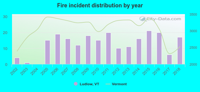 Based on the data from the years 2002 - 2018 the average number of fires per year is 13. The highest number of fire incidents - 21 took place in 2015, and the least - 0 in 2004. The data has a growing trend.
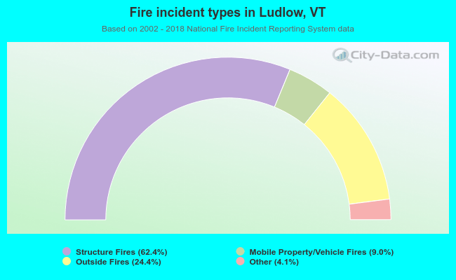 When looking into fire subcategories, the most reports belonged to: Structure Fires (62.4%), and Outside Fires (24.4%).
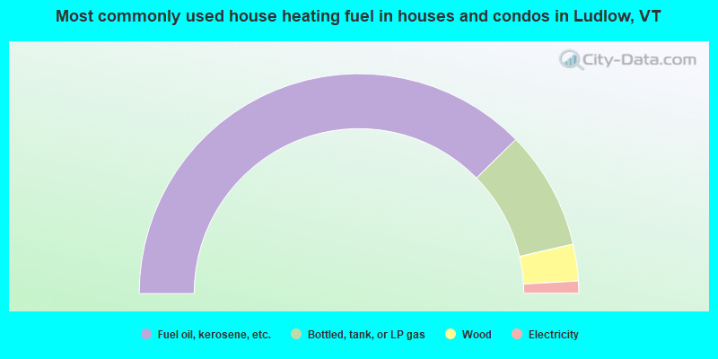
- 75.3%Fuel oil, kerosene, etc.
- 17.5%Bottled, tank, or LP gas
- 5.4%Wood
- 1.8%Electricity
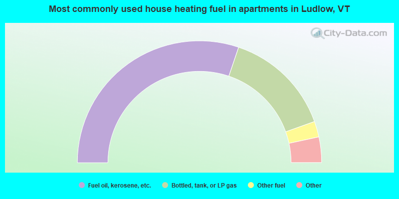
- 60.7%Fuel oil, kerosene, etc.
- 28.8%Bottled, tank, or LP gas
- 4.2%Other fuel
- 3.7%Utility gas
- 2.6%Electricity
Ludlow compared to Vermont state average:
- Median household income below state average.
- Unemployed percentage below state average.
- Black race population percentage significantly below state average.
- Hispanic race population percentage significantly below state average.
- Renting percentage above state average.
- House age above state average.
- Institutionalized population percentage significantly above state average.
- Number of college students significantly below state average.
Ludlow on our top lists:
- #59 on the list of "Top 101 cities with the most residents born in Other Western Africa (population 500+)"
- #39 on the list of "Top 101 counties with the highest percentage of residents that keep firearms around their homes"
- #40 on the list of "Top 101 counties with highest percentage of residents voting for Obama (Democrat) in the 2012 Presidential Election (pop. 50,000+)"
- #47 on the list of "Top 101 counties with the highest percentage of residents that smoked 100+ cigarettes in their lives"
- #54 on the list of "Top 101 counties with the lowest surface withdrawal of fresh water for public supply (pop. 50,000+)"
- #61 on the list of "Top 101 counties with the best general health status score of residents (1-5), 3 years of data"

|
Total of 7 patent applications in 2008-2024.