Bridge Statistics for Luther, Oklahoma (OK)
Condition, Traffic, Stress, Structural Evaluation, Project Costs
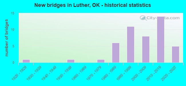
- New bridges - historical statistics
- 11920-1929
- 11950-1959
- 11970-1979
- 61980-1989
- 111990-1999
- 82000-2009
- 142010-2019
- 52020-2022
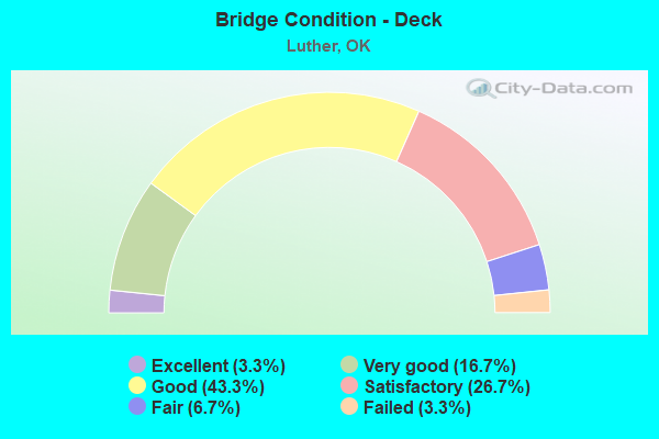
- Bridge Condition - Deck
- 3.3%Excellent
- 16.7%Very good
- 43.3%Good
- 26.7%Satisfactory
- 6.7%Fair
- 3.3%Failed
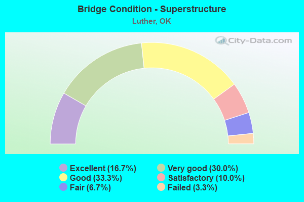
- Bridge Condition - Superstructure
- 16.7%Excellent
- 30.0%Very good
- 33.3%Good
- 10.0%Satisfactory
- 6.7%Fair
- 3.3%Failed
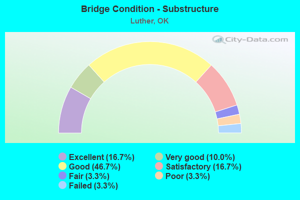
- Bridge Condition - Substructure
- 16.7%Excellent
- 10.0%Very good
- 46.7%Good
- 16.7%Satisfactory
- 3.3%Fair
- 3.3%Poor
- 3.3%Failed
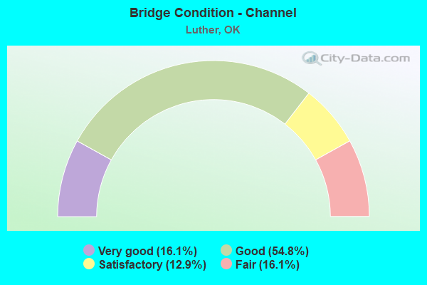
- Bridge Condition - Channel
- 16.1%Very good
- 54.8%Good
- 12.9%Satisfactory
- 16.1%Fair

- Bridge Condition - Culverts
- 11.1%Very good
- 55.6%Good
- 33.3%Satisfactory
Find on map >> Show street view
Structure Number: 32415, Location: .63W N LUTHER & NE 150TH (Lat: 35.623333, Lng: -97.199617), Route carried "under" structure: Interstate , Year Built: 2019, Structure Length: 0. m, Average Daily Traffic: 30,400 (year 2020), Truck Traffic: 12%, Features Intersected: KICKAPOO TP UNDER, Facility Carried by Structure: NE 150TH ST
Minimum Vertical Clearance: 5.51m (18.08ft), Kilometerpoint: 44.513, Lanes on structure: 2, Lanes under structure: 4, Toll: On toll road, Material/Design: Steel continuous, Design/Construction: Stringer/Multi-beam, Length of Maximum Span: 36.6m (120.1ft)
Find on map >> Show street view
Structure Number: 32416, Location: .26N N LUTHER & NE150TH (Lat: 35.626861, Lng: -97.194444), Route carried "under" structure: City street , Year Built: 2019, Structure Length: 0. m, Average Daily Traffic: 30,400 (year 2020), Truck Traffic: 12%, Features Intersected: KICKAPOO TP UNDER, Facility Carried by Structure: N LUTHER RD
Minimum Vertical Clearance: 6.40m (21.00ft), Kilometerpoint: 45.419, Lanes on structure: 2, Lanes under structure: 4, Toll: On toll road, Material/Design: Steel continuous, Design/Construction: Stringer/Multi-beam, Length of Maximum Span: 31.1m (102.0ft)
Find on map >> Show street view
Structure Number: 32417, Location: .20E OF N LUTHER &NE164TH (Lat: 35.637400, Lng: -97.191253), Route carried "under" structure: City street , Year Built: 2020, Structure Length: 0. m, Average Daily Traffic: 1,191 (year 2020), Truck Traffic: 7%, Features Intersected: NE 164TH ST UNDER, Facility Carried by Structure: KICKAPOO TP NB
Minimum Vertical Clearance: 5.51m (18.08ft), Kilometerpoint: 47.361, Lanes on structure: 2, Lanes under structure: 2, Material/Design: Prestressed concrete, Design/Construction: Stringer/Multi-beam, Length of Maximum Span: 27.4m (89.9ft)
Find on map >> Show street view
Structure Number: 32418, Location: .20E OF N LUTHER &NE164TH (Lat: 35.637400, Lng: -97.191639), Route carried "under" structure: City street , Year Built: 2020, Structure Length: 0. m, Average Daily Traffic: 1,191 (year 2020), Truck Traffic: 7%, Features Intersected: NE 164TH ST UNDER, Facility Carried by Structure: KICKAPOO TP SB
Minimum Vertical Clearance: 5.21m (17.09ft), Kilometerpoint: 47.361, Lanes on structure: 2, Lanes under structure: 2, Material/Design: Prestressed concrete, Design/Construction: Stringer/Multi-beam, Length of Maximum Span: 27.4m (89.9ft)
Find on map >> Show street view
Structure Number: 32419, Location: 2.34E HOGBACK RD & 1-44 (Lat: 35.643472, Lng: -97.191033), Route carried "under" structure: Interstate , Year Built: 2019, Structure Length: 0. m, Average Daily Traffic: 30,400 (year 2020), Truck Traffic: 12%, Features Intersected: TURNER TP (I-44) UNDER, Facility Carried by Structure: KICKAPOO TP
Minimum Vertical Clearance: 5.72m (18.77ft), Kilometerpoint: 35.475, Lanes on structure: 2, Lanes under structure: 4, Toll: On toll road, Material/Design: Prestressed concrete, Design/Construction: Stringer/Multi-beam, Length of Maximum Span: 38.3m (125.7ft)
Find on map >> Show street view
Structure Number: 3242, Location: 13.5 NE OF JCT 1-35 (Lat: 35.642814, Lng: -97.194558), Route carried "under" structure: Interstate , Year Built: 2020, Structure Length: 0. m, Average Daily Traffic: 30,400 (year 2020), Truck Traffic: 12%, Features Intersected: TURNER TP (I-44) UNDER, Facility Carried by Structure: N LUTHER RD
Minimum Vertical Clearance: 5.49m (18.01ft), Kilometerpoint: 34.958, Lanes on structure: 2, Lanes under structure: 4, Toll: On toll road, Material/Design: Prestressed concrete, Design/Construction: Stringer/Multi-beam, Length of Maximum Span: 40.1m (131.6ft)