Bridge Statistics for Marengo, Illinois (IL)
Condition, Traffic, Stress, Structural Evaluation, Project Costs
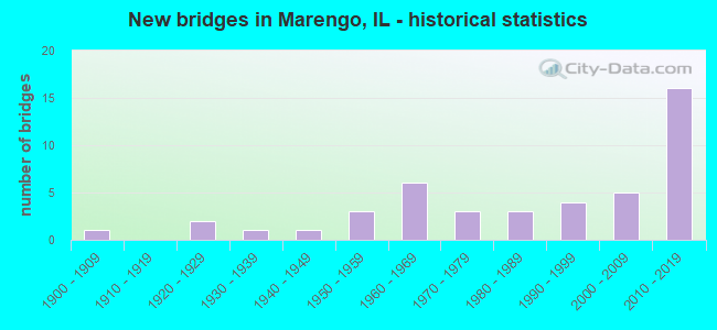
- New bridges - historical statistics
- 11900-1909
- 21920-1929
- 11930-1939
- 11940-1949
- 31950-1959
- 61960-1969
- 31970-1979
- 31980-1989
- 41990-1999
- 52000-2009
- 162010-2019
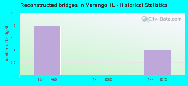
- Reconstructed bridges - Historical Statistics
- 21950-1959
- 01960-1969
- 11970-1979
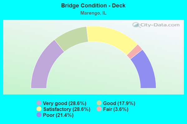
- Bridge Condition - Deck
- 28.6%Very good
- 17.9%Good
- 28.6%Satisfactory
- 3.6%Fair
- 21.4%Poor

- Bridge Condition - Superstructure
- 28.6%Very good
- 17.9%Good
- 28.6%Satisfactory
- 3.6%Fair
- 21.4%Poor
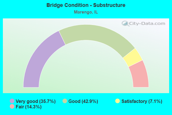
- Bridge Condition - Substructure
- 35.7%Very good
- 42.9%Good
- 7.1%Satisfactory
- 14.3%Fair
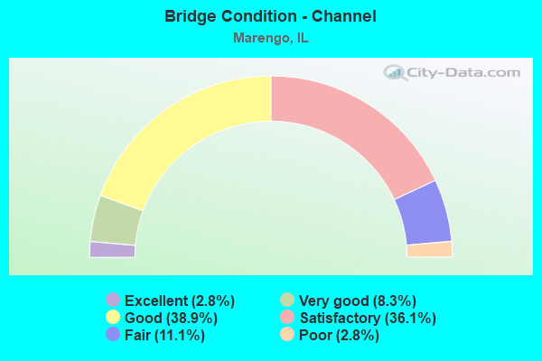
- Bridge Condition - Channel
- 2.8%Excellent
- 8.3%Very good
- 38.9%Good
- 36.1%Satisfactory
- 11.1%Fair
- 2.8%Poor
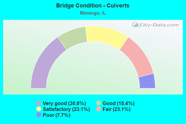
- Bridge Condition - Culverts
- 30.8%Very good
- 15.4%Good
- 23.1%Satisfactory
- 23.1%Fair
- 7.7%Poor
Find on map >> Show street view
Structure Number: 569923, Location: I-90 1M W of ILL 23 (Lat: 42.183050, Lng: -88.633500), Route carried "on" structure: County highway , Year Built: 2014, Status: Open, Structure Length: 9.65m (31.66ft), Average Daily Traffic: 1,450 (year 2021), Truck Traffic: 15%, Average Future Daily Traffic: 1,846 (year 2032), Design Load: HS 25 or greater, Features Intersected: Interstate 90, Facility Carried by Structure: Harmony Riley Road
Minimum Vertical Clearance: 30+ m (98+ ft), Kilometerpoint: 5.118, Lanes on structure: 2, Lanes under structure: 4, Owner: County Highway Agency, Approaching Roadway Width: 10.4m (34.1ft), Skew: 4 degrees, Material/Design: Steel continuous, Design/Construction: Stringer/Multi-beam, Number Of Spans In Main Unit: 2, Length of Maximum Span: 47.5m (155.8ft), Curb-To-Curb Width: 10.4m (34.1ft), Out-to-Out Width: 11.4m (37.4ft)
Condition: Deck: Good, Superstructure: Good, Substructure: Very good, Operating Rating: 47.0 metric tons, Method Used To Determine Operating Rating: Load and Resistance Factor Rating (LRFR) rating reported by rating factor(RF) method using HL-93 loadings, Inventory Rating: 36.3 metric tons, Method Used To Determine Inventory Rating: Load and Resistance Factor Rating (LRFR) rating reported by rating factor(RF) method using HL-93 loadings, Structural Evaluation: Better than present minimum criteria, Deck Geometry: Equal to present minimum criteria, Underclear: Somewhat better than minimum adequacy, Approach Roadway Alignment: Equal to present desirable criteria, Designated Inspection Frequency: Every 24 months, Inspection Date: August 2020, Deck Structure Type: Concrete Cast-file-Place, Wearing Surface/Protective System: Deck Protection: Epoxy Coated Reinforcing
Find on map >> Show street view
Structure Number: 560331, Location: I-90 @ IL23 (Lat: 42.177611, Lng: -88.618000), Route carried "under" structure: Interstate 90, Year Built: 2017, Structure Length: 0. m, Average Daily Traffic: 46,600 (year 2020), Truck Traffic: 26%, Features Intersected: I- 90 Jane Adams, Facility Carried by Structure: IL 23
Minimum Vertical Clearance: 5.03m (16.50ft), Kilometerpoint: 58.144, Lanes on structure: 2, Lanes under structure: 6, Material/Design: Prestressed concrete continuous, Design/Construction: Stringer/Multi-beam, Length of Maximum Span: 42.2m (138.5ft)
Find on map >> Show street view
Structure Number: 569908, Location: I 90 2.8 MI W ILL 23 (Lat: 42.194625, Lng: -88.666994), Route carried "under" structure: Interstate 90, Year Built: 2015, Structure Length: 0. m, Average Daily Traffic: 46,600 (year 2020), Truck Traffic: 26%, Features Intersected: I 90, Facility Carried by Structure: ANTHONY RD
Minimum Vertical Clearance: 5.00m (16.40ft), Kilometerpoint: 53.702, Lanes on structure: 2, Lanes under structure: 6, Material/Design: Steel continuous, Design/Construction: Stringer/Multi-beam, Length of Maximum Span: 48.8m (160.1ft)
Find on map >> Show street view
Structure Number: 569922, Location: 0.5 M N of Dekalb CO (Lat: 42.169050, Lng: -88.593650), Route carried "under" structure: Interstate 90, Year Built: 2013, Structure Length: 0. m, Average Daily Traffic: 46,600 (year 2020), Truck Traffic: 26%, Features Intersected: Interstate 90, Facility Carried by Structure: Getty Road
Minimum Vertical Clearance: 5.00m (16.40ft), Kilometerpoint: 60.365, Lanes on structure: 2, Lanes under structure: 4, Material/Design: Steel continuous, Design/Construction: Stringer/Multi-beam, Length of Maximum Span: 41.2m (135.2ft)
Find on map >> Show street view
Structure Number: 569923, Location: I-90 1M W of ILL 23 (Lat: 42.183050, Lng: -88.633500), Route carried "under" structure: Interstate 90, Year Built: 2014, Structure Length: 0. m, Average Daily Traffic: 46,600 (year 2020), Truck Traffic: 26%, Features Intersected: Interstate 90, Facility Carried by Structure: Harmony Riley Road
Minimum Vertical Clearance: 5.00m (16.40ft), Kilometerpoint: 56.744, Lanes on structure: 2, Lanes under structure: 4, Material/Design: Steel continuous, Design/Construction: Stringer/Multi-beam, Length of Maximum Span: 47.5m (155.8ft)