Bridge Statistics for Milwaukee, Wisconsin (WI)
Condition, Traffic, Stress, Structural Evaluation, Project Costs
- National Bridge Inventory (NBI) Statistics
- 974Number of bridges
- 17,654ft / 5,381mTotal length
- $387,591,000Total costs
- 28,051,907Total average daily traffic
- 635,923Total average daily truck traffic
- National Bridge Inventory (NBI) Registered Bridges for Milwaukee
- No street view available for this location
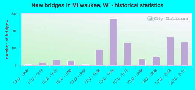
- New bridges - historical statistics
- 1Before 1900
- 61900-1909
- 161910-1919
- 331920-1929
- 271930-1939
- 51940-1949
- 891950-1959
- 2731960-1969
- 1301970-1979
- 371980-1989
- 511990-1999
- 1682000-2009
- 1382010-2019
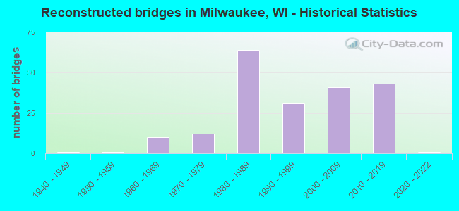
- Reconstructed bridges - Historical Statistics
- 11940-1949
- 11950-1959
- 101960-1969
- 121970-1979
- 641980-1989
- 311990-1999
- 412000-2009
- 432010-2019
- 12020-2022
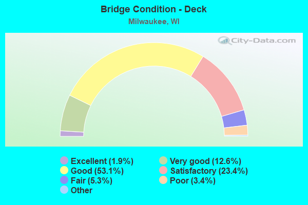
- Bridge Condition - Deck
- 1.9%Excellent
- 12.6%Very good
- 53.1%Good
- 23.4%Satisfactory
- 5.3%Fair
- 3.4%Poor
- 0.4%Serious
- 0.2%Failed
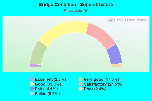
- Bridge Condition - Superstructure
- 2.3%Excellent
- 17.5%Very good
- 39.0%Good
- 24.5%Satisfactory
- 14.1%Fair
- 2.4%Poor
- 0.2%Failed
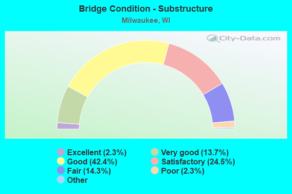
- Bridge Condition - Substructure
- 2.3%Excellent
- 13.7%Very good
- 42.4%Good
- 24.5%Satisfactory
- 14.3%Fair
- 2.3%Poor
- 0.6%Serious
- 0.2%Critical
- 0.2%Failed
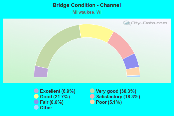
- Bridge Condition - Channel
- 6.9%Excellent
- 38.3%Very good
- 21.7%Good
- 18.3%Satisfactory
- 8.6%Fair
- 5.1%Poor
- 1.1%Serious
- 0.6%Failed
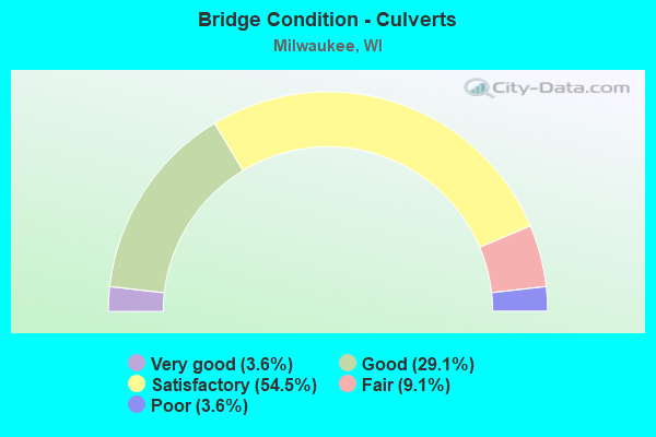
- Bridge Condition - Culverts
- 3.6%Very good
- 29.1%Good
- 54.5%Satisfactory
- 9.1%Fair
- 3.6%Poor
Find on map >> Show street view
Structure Number: B4011230001, Location: MARQUETTE INTERCHANGE (Lat: 43.035408, Lng: -87.923253), Route carried "under" structure: Ramp Interstate 794, Year Built: 2008, Structure Length: 0. m, Average Daily Traffic: 100,000 (year 2019), Features Intersected: IH 43 & IH 794, Facility Carried by Structure: IH S-W RAMP, IH 43
Minimum Vertical Clearance: 5.00m (16.40ft), Kilometerpoint: 0.000, Lanes on structure: 1, Lanes under structure: 1, Material/Design: Steel continuous, Design/Construction: Box Beam or Girders - Multiple, Length of Maximum Span: 68.6m (225.1ft)
Find on map >> Show street view
Structure Number: B4011230002, Location: AT IH94 (Lat: 43.033097, Lng: -87.922208), Route carried "under" structure: Ramp Interstate 794, Year Built: 2008, Structure Length: 0. m, Average Daily Traffic: 11,400 (year 2019), Features Intersected: IH E-S RAMP, IH 794 WB -, Facility Carried by Structure: IH S-W RAMP, IH 43
Minimum Vertical Clearance: 5.17m (16.96ft), Kilometerpoint: 0.000, Lanes on structure: 2, Lanes under structure: 1, Material/Design: Steel continuous, Design/Construction: Box Beam or Girders - Multiple, Length of Maximum Span: 70.1m (230.0ft)
Find on map >> Show street view
Structure Number: B401131, Location: 1.2M N OFIH-43-94/GREEN (Lat: 43.033025, Lng: -87.921947), Route carried "under" structure: City street , Year Built: 2006, Structure Length: 0. m, Average Daily Traffic: 6,700 (year 2018), Features Intersected: LRD ST PAUL AVE, Facility Carried by Structure: IH RAMP, IH 43 NB/
Minimum Vertical Clearance: 8.90m (29.20ft), Kilometerpoint: 0.000, Lanes on structure: 1, Lanes under structure: 2, Material/Design: Steel continuous, Design/Construction: Box Beam or Girders - Multiple, Length of Maximum Span: 76.2m (250.0ft)
Find on map >> Show street view
Structure Number: B401132, Location: AT IH43 (Lat: 43.034997, Lng: -87.923069), Route carried "under" structure: Interstate 794, Year Built: 2008, Structure Length: 0. m, Average Daily Traffic: 100,000 (year 2019), Features Intersected: IH 794, Facility Carried by Structure: IH RAMP IH43NB-MIC
Minimum Vertical Clearance: 5.23m (17.16ft), Kilometerpoint: 0.000, Lanes on structure: 1, Lanes under structure: 4, Material/Design: Steel continuous, Design/Construction: Stringer/Multi-beam, Length of Maximum Span: 50.3m (165.0ft)
Find on map >> Show street view
Structure Number: B4012110001, Location: AT IH43 (Lat: 43.034944, Lng: -87.924011), Route carried "under" structure: Ramp Interstate 43, Year Built: 2008, Structure Length: 0. m, Average Daily Traffic: 11,400 (year 2019), Features Intersected: IH N-E RAMP
Minimum Vertical Clearance: 5.20m (17.06ft), Kilometerpoint: 0.000, Lanes on structure: 3, Lanes under structure: 2, Material/Design: Steel continuous, Design/Construction: Stringer/Multi-beam, Length of Maximum Span: 59.1m (193.9ft)
Find on map >> Show street view
Structure Number: B4012110002, Location: AT IH43 (Lat: 43.037372, Lng: -87.925153), Route carried "under" structure: Interstate 794, Year Built: 2008, Structure Length: 0. m, Average Daily Traffic: 100,000 (year 2019), Features Intersected: IH 794, Facility Carried by Structure: IH 43 SB
Minimum Vertical Clearance: 6.39m (20.96ft), Kilometerpoint: 0.000, Lanes on structure: 2, Lanes under structure: 5, Material/Design: Steel continuous, Design/Construction: Stringer/Multi-beam, Length of Maximum Span: 59.4m (194.9ft)
Find on map >> Show street view
Structure Number: B4012210001, Location: AT INTERSECTION (Lat: 43.037344, Lng: -87.925342), Route carried "under" structure: Interstate 794, Year Built: 2008, Structure Length: 0. m, Average Daily Traffic: 100,000 (year 2019), Features Intersected: IH 794, Facility Carried by Structure: IH N-E RAMP, IH 43
Minimum Vertical Clearance: 4.99m (16.37ft), Kilometerpoint: 0.000, Lanes on structure: 1, Lanes under structure: 5, Material/Design: Steel continuous, Design/Construction: Box Beam or Girders - Multiple, Length of Maximum Span: 70.1m (230.0ft)
Find on map >> Show street view
Structure Number: B4012210002, Location: N TO E RAMP (Lat: 43.035317, Lng: -87.924761), Route carried "under" structure: City street , Year Built: 2008, Structure Length: 0. m, Average Daily Traffic: 6,700 (year 2018), Features Intersected: LRD W ST PAUL AVE, Facility Carried by Structure: IH N-E RAMP, IH 43
Minimum Vertical Clearance: 4.94m (16.21ft), Kilometerpoint: 0.000, Lanes on structure: 1, Lanes under structure: 2, Material/Design: Steel continuous, Design/Construction: Box Beam or Girders - Multiple, Length of Maximum Span: 71.6m (234.9ft)
Find on map >> Show street view
Structure Number: B401222, Location: AT 43NB RAMP (Lat: 43.037317, Lng: -87.925642), Route carried "under" structure: City street , Year Built: 2006, Structure Length: 0. m, Average Daily Traffic: 5,900 (year 2018), Features Intersected: LRD N 13TH ST & W TORY H, Facility Carried by Structure: IH N-W RAMP, IH 43
Minimum Vertical Clearance: 5.90m (19.36ft), Kilometerpoint: 0.000, Lanes on structure: 2, Lanes under structure: 4, Material/Design: Steel continuous, Design/Construction: Box Beam or Girders - Multiple, Length of Maximum Span: 50.3m (165.0ft)
Find on map >> Show street view
Structure Number: B4012310001, Location: MARQUETTE INTERCHANGE (Lat: 43.037333, Lng: -87.925522), Route carried "under" structure: Ramp Interstate 794, Year Built: 2008, Structure Length: 0. m, Average Daily Traffic: 100,000 (year 2019), Features Intersected: IH 794, Facility Carried by Structure: IH RAMP WISC AV-IH
Minimum Vertical Clearance: 5.19m (17.03ft), Kilometerpoint: 0.000, Lanes on structure: 1, Lanes under structure: 4, Material/Design: Steel continuous, Design/Construction: Stringer/Multi-beam, Length of Maximum Span: 53.3m (174.9ft)
Find on map >> Show street view
Structure Number: B4012310002, Location: MARQUETTE INTERCHANGE (Lat: 43.038572, Lng: -87.925428), Route carried "under" structure: Interstate , Year Built: 2008, Structure Length: 0. m, Average Daily Traffic: 11,400 (year 2019), Features Intersected: IH RAMP IH43SB-IH94WB, Facility Carried by Structure: IH RAMP WISC AVE-I
Minimum Vertical Clearance: 4.93m (16.17ft), Kilometerpoint: 0.000, Lanes on structure: 1, Lanes under structure: 2, Material/Design: Steel continuous, Design/Construction: Stringer/Multi-beam, Length of Maximum Span: 32.0m (105.0ft)
Find on map >> Show street view
Structure Number: B4013110001, Location: AT CP RR (Lat: 43.035556, Lng: -87.928392), Route carried "under" structure: City street , Year Built: 2006, Structure Length: 0. m, Average Daily Traffic: 5,100 (year 2018), Features Intersected: LRD S 13TH ST, Facility Carried by Structure: IH 794 EB
Minimum Vertical Clearance: 5.03m (16.50ft), Kilometerpoint: 0.000, Lanes on structure: 4, Lanes under structure: 4, Material/Design: Prestressed concrete continuous, Design/Construction: Stringer/Multi-beam, Length of Maximum Span: 37.8m (124.0ft)
Find on map >> Show street view
Structure Number: B4013110002, Location: 0.80 M E OFIH-94/16TH ST (Lat: 43.035697, Lng: -87.926228), Route carried "under" structure: Ramp Other road , Year Built: 2006, Structure Length: 0. m, Average Daily Traffic: 38,100 (year 2019), Features Intersected: W-N RAMP IH 94 EB-IH 43, Facility Carried by Structure: IH 794 EB
Minimum Vertical Clearance: 5.03m (16.50ft), Kilometerpoint: 0.000, Lanes on structure: 2, Lanes under structure: 1, Material/Design: Prestressed concrete continuous, Design/Construction: Stringer/Multi-beam, Length of Maximum Span: 36.5m (119.8ft)
Find on map >> Show street view
Structure Number: B4013120001, Location: AT 794 (Lat: 43.035653, Lng: -87.920975), Route carried "under" structure: City street , Year Built: 2006, Structure Length: 0. m, Average Daily Traffic: 3,600 (year 2018), Features Intersected: LRD JAMES LOVELL ST, Facility Carried by Structure: IH-794 EB
Minimum Vertical Clearance: 5.88m (19.29ft), Kilometerpoint: 0.000, Lanes on structure: 2, Lanes under structure: 1, Material/Design: Prestressed concrete continuous, Design/Construction: Stringer/Multi-beam, Length of Maximum Span: 42.7m (140.1ft)
Find on map >> Show street view
Structure Number: B4013120002, Location: AT 794 (Lat: 43.035769, Lng: -87.917336), Route carried "under" structure: City street , Year Built: 2006, Structure Length: 0. m, Average Daily Traffic: 540 (year 2019), Features Intersected: LRD 3RD ST, Facility Carried by Structure: IH-794 EB
Minimum Vertical Clearance: 7.19m (23.59ft), Kilometerpoint: 0.000, Lanes on structure: 3, Lanes under structure: 2, Material/Design: Prestressed concrete continuous, Design/Construction: Stringer/Multi-beam, Length of Maximum Span: 41.1m (134.8ft)
Find on map >> Show street view
Structure Number: B4013120003, Location: AT 2ND ST UNDER IH 794 (Lat: 43.035683, Lng: -87.914356), Route carried "under" structure: Ramp Interstate , Year Built: 2006, Structure Length: 0. m, Average Daily Traffic: 11,200 (year 2019), Features Intersected: IH 2ND ST/RAMP TO IH 43, Facility Carried by Structure: IH 794 EB
Minimum Vertical Clearance: 5.11m (16.77ft), Kilometerpoint: 0.000, Lanes on structure: 3, Lanes under structure: 2, Material/Design: Prestressed concrete continuous, Design/Construction: Stringer/Multi-beam, Length of Maximum Span: 44.2m (145.0ft)
Find on map >> Show street view
Structure Number: B4013120005, Location: AT 794 (Lat: 43.035081, Lng: -87.920558), Route carried "under" structure: Ramp City street , Year Built: 2006, Structure Length: 0. m, Average Daily Traffic: 2,900 (year 2019), Features Intersected: LRD RAMP, IH 794 EB - ST, Facility Carried by Structure: IH RAMP, IH 94 WB
Minimum Vertical Clearance: 5.19m (17.03ft), Kilometerpoint: 0.000, Lanes on structure: 2, Lanes under structure: 1, Material/Design: Prestressed concrete continuous, Design/Construction: Stringer/Multi-beam, Length of Maximum Span: 35.1m (115.2ft)
Find on map >> Show street view
Structure Number: B4013120006, Location: 1.5M E OF IH-94/16TH ST (Lat: 43.035464, Lng: -87.914350), Route carried "under" structure: City street , Year Built: 2006, Structure Length: 0. m, Average Daily Traffic: 4,400 (year 2019), Features Intersected: LRD 2ND ST, Facility Carried by Structure: IH RAMP, IH 43 NB/
Minimum Vertical Clearance: 4.79m (15.72ft), Kilometerpoint: 0.000, Lanes on structure: 1, Lanes under structure: 2, Material/Design: Prestressed concrete continuous, Design/Construction: Stringer/Multi-beam, Length of Maximum Span: 30.5m (100.1ft)
Find on map >> Show street view
Structure Number: B401321, Location: AT 43 (Lat: 43.035578, Lng: -87.926300), Route carried "under" structure: Ramp Interstate 43, Year Built: 2006, Structure Length: 0. m, Average Daily Traffic: 38,100 (year 2019), Features Intersected: IH RAMP, IH 94 EB - IH 4, Facility Carried by Structure: IH RAMP, IH 94 EB
Minimum Vertical Clearance: 5.48m (17.98ft), Kilometerpoint: 0.000, Lanes on structure: 2, Lanes under structure: 4, Material/Design: Steel continuous, Design/Construction: Box Beam or Girders - Multiple, Length of Maximum Span: 73.2m (240.2ft)
Find on map >> Show street view
Structure Number: B401322, Location: 1.0M S (Lat: 43.035389, Lng: -87.928397), Route carried "under" structure: City street , Year Built: 2006, Structure Length: 0. m, Average Daily Traffic: 5,900 (year 2018), Features Intersected: LRD 13TH ST, Facility Carried by Structure: IH W-N RAMP IH94 E
Minimum Vertical Clearance: 5.03m (16.50ft), Kilometerpoint: 0.000, Lanes on structure: 2, Lanes under structure: 4, Material/Design: Prestressed concrete continuous, Design/Construction: Stringer/Multi-beam, Length of Maximum Span: 36.0m (118.1ft)
Find on map >> Show street view
Structure Number: B401323, Location: AT TORY HILL (Lat: 43.037186, Lng: -87.924225), Route carried "under" structure: Ramp Interstate 43, Year Built: 2004, Structure Length: 0. m, Average Daily Traffic: 38,100 (year 2019), Features Intersected: IH W-N RAMP,I 94 EB-I 43, Facility Carried by Structure: LRD TORY HILL-MICH
Minimum Vertical Clearance: 5.00m (16.40ft), Kilometerpoint: 0.000, Lanes on structure: 5, Lanes under structure: 2, Material/Design: Prestressed concrete, Design/Construction: Stringer/Multi-beam, Length of Maximum Span: 15.2m (49.9ft)
Find on map >> Show street view
Structure Number: B4014110001, Location: MARQUETTE INETRCHANGE (Lat: 43.035975, Lng: -87.927050), Route carried "under" structure: City street , Year Built: 2008, Structure Length: 0. m, Average Daily Traffic: 5,900 (year 2018), Features Intersected: LRD 13TH ST, Facility Carried by Structure: IH 794 WB
Minimum Vertical Clearance: 5.39m (17.68ft), Kilometerpoint: 0.000, Lanes on structure: 3, Lanes under structure: 4, Material/Design: Prestressed concrete continuous, Design/Construction: Stringer/Multi-beam, Length of Maximum Span: 37.8m (124.0ft)
Find on map >> Show street view
Structure Number: B4014110002, Location: MARQUETTE INETRCHANGE (Lat: 43.035772, Lng: -87.923067), Route carried "under" structure: Ramp Interstate 94, Year Built: 2008, Structure Length: 0. m, Average Daily Traffic: 38,100 (year 2019), Features Intersected: IH W-N RAMP 94EBTO43NB
Minimum Vertical Clearance: 5.29m (17.36ft), Kilometerpoint: 0.000, Lanes on structure: 2, Lanes under structure: 2, Material/Design: Prestressed concrete continuous, Design/Construction: Stringer/Multi-beam, Length of Maximum Span: 36.1m (118.4ft)
Find on map >> Show street view
Structure Number: B4014120001, Location: AT 794 (Lat: 43.035914, Lng: -87.916333), Route carried "under" structure: City street , Year Built: 2008, Structure Length: 0. m, Average Daily Traffic: 26,200 (year 2018), Features Intersected: LRD 6TH ST, Facility Carried by Structure: IH 794 WB
Minimum Vertical Clearance: 5.65m (18.54ft), Kilometerpoint: 0.000, Lanes on structure: 1, Lanes under structure: 4, Material/Design: Prestressed concrete continuous, Design/Construction: Stringer/Multi-beam, Length of Maximum Span: 44.2m (145.0ft)
Find on map >> Show street view
Structure Number: B4014120002, Location: AT 794 (Lat: 43.035942, Lng: -87.914361), Route carried "under" structure: City street , Year Built: 2008, Structure Length: 0. m, Average Daily Traffic: 2,000 (year 2019), Features Intersected: LRD 4TH ST, Facility Carried by Structure: IH 794 WB
Minimum Vertical Clearance: 6.70m (21.98ft), Kilometerpoint: 0.000, Lanes on structure: 5, Lanes under structure: 4, Material/Design: Prestressed concrete continuous, Design/Construction: Stringer/Multi-beam, Length of Maximum Span: 41.1m (134.8ft)
Find on map >> Show street view
Structure Number: B4014120003, Location: AT 794 (Lat: 43.035981, Lng: -87.910514), Route carried "under" structure: Ramp Interstate , Year Built: 2008, Structure Length: 0. m, Average Daily Traffic: 7,100 (year 2019), Features Intersected: IH E-N ENTRANCE RAMP, Facility Carried by Structure: IH 794 WB
Minimum Vertical Clearance: 5.27m (17.29ft), Kilometerpoint: 0.000, Lanes on structure: 4, Lanes under structure: 1, Material/Design: Prestressed concrete continuous, Design/Construction: Stringer/Multi-beam, Length of Maximum Span: 44.2m (145.0ft)
Find on map >> Show street view
Structure Number: B4014120005, Location: AT INTERSECTION (Lat: 43.036078, Lng: -87.916339), Route carried "under" structure: City street , Year Built: 2008, Structure Length: 0. m, Average Daily Traffic: 26,200 (year 2018), Features Intersected: LRD 6TH ST, Facility Carried by Structure: IH 794 WB
Minimum Vertical Clearance: 6.82m (22.38ft), Kilometerpoint: 0.000, Lanes on structure: 3, Lanes under structure: 5, Material/Design: Prestressed concrete continuous, Design/Construction: Stringer/Multi-beam, Length of Maximum Span: 45.7m (149.9ft)
Find on map >> Show street view
Structure Number: B4014120006, Location: 1.7M W OF STH32 (Lat: 43.035981, Lng: -87.912047), Route carried "under" structure: Ramp Interstate , Year Built: 2008, Structure Length: 0. m, Average Daily Traffic: 7,100 (year 2019), Features Intersected: IH E-N ENTRANCE RAMP, Facility Carried by Structure: IH 794 WB
Minimum Vertical Clearance: 5.16m (16.93ft), Kilometerpoint: 0.000, Lanes on structure: 1, Lanes under structure: 2, Material/Design: Prestressed concrete continuous, Design/Construction: Stringer/Multi-beam, Length of Maximum Span: 45.7m (149.9ft)
Find on map >> Show street view
Structure Number: B4014120007, Location: 1.7M W OF STH32 (Lat: 43.036072, Lng: -87.919497), Route carried "under" structure: Ramp City street 794, Year Built: 2008, Structure Length: 0. m, Average Daily Traffic: 3,700 (year 2019), Features Intersected: LRD RAMP794E TO JAMES LO
Minimum Vertical Clearance: 8.64m (28.35ft), Kilometerpoint: 0.000, Lanes on structure: 3, Lanes under structure: 2, Material/Design: Prestressed concrete continuous, Design/Construction: Stringer/Multi-beam, Length of Maximum Span: 44.2m (145.0ft)
Find on map >> Show street view
Structure Number: B4014210001, Location: AT 794 (Lat: 43.037086, Lng: -87.924364), Route carried "under" structure: City street , Year Built: 2008, Structure Length: 0. m, Average Daily Traffic: 7,700 (year 2018), Truck Traffic: 5%, Features Intersected: LRD TORY HILL, Facility Carried by Structure: IH RAMP E-N I794WB
Minimum Vertical Clearance: 5.03m (16.50ft), Kilometerpoint: 0.000, Lanes on structure: 1, Lanes under structure: 4, Material/Design: Steel continuous, Design/Construction: Stringer/Multi-beam, Length of Maximum Span: 19.8m (65.0ft)
Find on map >> Show street view
Structure Number: B4014210002, Location: AT INTERSECTION (Lat: 43.036117, Lng: -87.921097), Route carried "under" structure: Ramp Interstate 94, Year Built: 2008, Structure Length: 0. m, Average Daily Traffic: 15,000 (year 2019), Features Intersected: IH W TO N RAMP(94EB-43NB
Minimum Vertical Clearance: 5.24m (17.19ft), Kilometerpoint: 0.000, Lanes on structure: 1, Lanes under structure: 2, Material/Design: Steel continuous, Design/Construction: Box Beam or Girders - Multiple, Length of Maximum Span: 54.3m (178.1ft)
Find on map >> Show street view
Structure Number: B4014220001, Location: MARQUETTE INTERCHANGE (Lat: 43.035258, Lng: -87.923292), Route carried "under" structure: Ramp Interstate 94, Year Built: 2008, Structure Length: 0. m, Average Daily Traffic: 11,400 (year 2019), Features Intersected: IH W - S RAMP ( IH 94 EB, Facility Carried by Structure: IH E - S RAMP (IH
Minimum Vertical Clearance: 5.16m (16.93ft), Kilometerpoint: 0.000, Lanes on structure: 2, Lanes under structure: 4, Material/Design: Steel continuous, Design/Construction: Box Beam or Girders - Multiple, Length of Maximum Span: 69.6m (228.3ft)
Find on map >> Show street view
Structure Number: B4014220002, Location: MARQUETTE INETRCHANGE (Lat: 43.035925, Lng: -87.921089), Route carried "under" structure: Ramp Interstate 794, Year Built: 2008, Structure Length: 0. m, Average Daily Traffic: 66,800 (year 2019), Features Intersected: IH 794, Facility Carried by Structure: IH E - S RAMP (IH
Minimum Vertical Clearance: 5.15m (16.90ft), Kilometerpoint: 0.000, Lanes on structure: 2, Lanes under structure: 4, Material/Design: Steel continuous, Design/Construction: Box Beam or Girders - Multiple, Length of Maximum Span: 51.8m (169.9ft)
Find on map >> Show street view
Structure Number: B401423, Location: AT RAMP E-S,I794WB-I94 EB (Lat: 43.033103, Lng: -87.923469), Route carried "under" structure: Other road , Year Built: 2011, Structure Length: 0. m, Average Daily Traffic: 6,700 (year 2019), Features Intersected: CANADIAN PACIFIC RR & CA, Facility Carried by Structure: IH RAMP E-S,I794WB
Minimum Vertical Clearance: 30+ m (98+ ft), Kilometerpoint: 0.000, Lanes on structure: 1, Lanes under structure: 4, Material/Design: Steel continuous, Design/Construction: Stringer/Multi-beam, Length of Maximum Span: 78.0m (255.9ft)
Find on map >> Show street view
Structure Number: P400417, Location: 1.3M W JCT STH 62 (Lat: 42.944728, Lng: -87.885111), Route carried "under" structure: City street , Year Built: 1939, Structure Length: 0. m, Average Daily Traffic: 600 (year 2019), Features Intersected: LRD GRANGE AVE, Facility Carried by Structure: C & NW TRANS CO
Minimum Vertical Clearance: 4.27m (14.01ft), Kilometerpoint: 0.000, Lanes under structure: 2, Material/Design: Steel, Design/Construction: Stringer/Multi-beam, Length of Maximum Span: 14.3m (46.9ft)
Find on map >> Show street view
Structure Number: P400526, Location: 1.5M N JCT USH 18 (Lat: 43.060953, Lng: -87.875436), Route carried "under" structure: City street , Year Built: 1955, Structure Length: 0. m, Average Daily Traffic: 16,100 (year 2019), Features Intersected: LRD N LINCOLN MEMORIAL D, Facility Carried by Structure: PEDESTRIAN WALKWAY
Minimum Vertical Clearance: 4.25m (13.94ft), Kilometerpoint: 0.000, Lanes under structure: 4, Material/Design: Concrete continuous, Design/Construction: Frame, Length of Maximum Span: 23.2m (76.1ft)
Find on map >> Show street view
Structure Number: P400533, Location: 0.5M N JCT USH 18 (Lat: 43.043261, Lng: -87.983094), Route carried "under" structure: City street , Year Built: 1959, Structure Length: 0. m, Average Daily Traffic: 7,800 (year 2018), Features Intersected: LRD W STATE ST, Facility Carried by Structure: LRD RAMP STATE ST-
Minimum Vertical Clearance: 4.42m (14.50ft), Kilometerpoint: 0.000, Lanes on structure: 1, Lanes under structure: 4, Material/Design: Steel continuous, Design/Construction: Stringer/Multi-beam, Length of Maximum Span: 24.4m (80.1ft)
Find on map >> Show street view
Structure Number: P400576, Location: 0.2M E JCT STH 32 (Lat: 43.069139, Lng: -87.868900), Route carried "under" structure: City street , Year Built: 1940, Structure Length: 0. m, Average Daily Traffic: 1,000 (year 2019), Features Intersected: LRD RAVINE RD, Facility Carried by Structure: PEDESTRIAN ACCESS
Minimum Vertical Clearance: 12.23m (40.12ft), Kilometerpoint: 0.000, Lanes under structure: 2, Material/Design: Concrete, Design/Construction: Arch - Deck, Length of Maximum Span: 39.8m (130.6ft)
Find on map >> Show street view
Structure Number: P400605, Location: 0.1M E JCT IH 43 (Lat: 43.027378, Lng: -87.909986), Route carried "under" structure: City street , Year Built: 1916, Structure Length: 0. m, Average Daily Traffic: 10,000 (year 2019), Features Intersected: LRD E FLORIDA ST, Facility Carried by Structure: CMSTPP RR
Minimum Vertical Clearance: 3.74m (12.27ft), Kilometerpoint: 0.000, Lanes under structure: 2, Material/Design: Concrete, Design/Construction: Slab, Length of Maximum Span: 7.4m (24.3ft)
Find on map >> Show street view
Structure Number: P400607, Location: 0.2M E JCT STH 32 (Lat: 43.017058, Lng: -87.908731), Route carried "under" structure: City street , Year Built: 1915, Structure Length: 0. m, Average Daily Traffic: 3,300 (year 2019), Features Intersected: LRD E GREENFIELD AVE, Facility Carried by Structure: CNW RR
Minimum Vertical Clearance: 4.17m (13.68ft), Kilometerpoint: 0.000, Lanes under structure: 2, Material/Design: Concrete, Design/Construction: Slab, Length of Maximum Span: 6.9m (22.6ft)
Find on map >> Show street view
Structure Number: P400608, Location: 0.1M E JCT STH 32 (Lat: 43.017136, Lng: -87.908456), Route carried "under" structure: City street , Year Built: 1915, Structure Length: 0. m, Average Daily Traffic: 17,000 (year 2019), Features Intersected: LRD E GREENFIELD AVE, Facility Carried by Structure: CMSTPP RR
Minimum Vertical Clearance: 4.17m (13.68ft), Kilometerpoint: 0.000, Lanes under structure: 2, Material/Design: Concrete, Design/Construction: Slab, Length of Maximum Span: 6.9m (22.6ft)
Find on map >> Show street view
Structure Number: P400611, Location: 0.2M E JCT STH 32 (Lat: 43.023317, Lng: -87.907122), Route carried "under" structure: City street , Year Built: 1909, Structure Length: 0. m, Average Daily Traffic: 17,000 (year 2019), Features Intersected: LRD E NATIONAL AVE, Facility Carried by Structure: CMSTPP RR
Minimum Vertical Clearance: 3.85m (12.63ft), Kilometerpoint: 0.000, Lanes under structure: 4, Material/Design: Concrete, Design/Construction: Slab, Length of Maximum Span: 7.5m (24.6ft)
Find on map >> Show street view
Structure Number: P400612, Location: 0.1M E JCT IH 43 (Lat: 43.023322, Lng: -87.909267), Route carried "under" structure: City street , Year Built: 1916, Structure Length: 0. m, Average Daily Traffic: 16,000 (year 2019), Features Intersected: LRD E NATIONAL AVE, Facility Carried by Structure: CNW RR
Minimum Vertical Clearance: 3.85m (12.63ft), Kilometerpoint: 0.000, Lanes under structure: 4, Material/Design: Concrete, Design/Construction: Slab, Length of Maximum Span: 7.5m (24.6ft)
Find on map >> Show street view
Structure Number: P400613, Location: 0.1M E JCT STH 32 (Lat: 43.023336, Lng: -87.908467), Route carried "under" structure: City street , Year Built: 1916, Structure Length: 0. m, Average Daily Traffic: 16,000 (year 2019), Features Intersected: LRD E NATIONAL AVE, Facility Carried by Structure: CNW RR
Minimum Vertical Clearance: 3.85m (12.63ft), Kilometerpoint: 0.000, Lanes under structure: 4, Material/Design: Concrete, Design/Construction: Slab, Length of Maximum Span: 7.5m (24.6ft)
Find on map >> Show street view
Structure Number: P400614, Location: 0.1M E JCT STH 32 (Lat: 43.023331, Lng: -87.908342), Route carried "under" structure: City street , Year Built: 1916, Structure Length: 0. m, Average Daily Traffic: 16,000 (year 2019), Features Intersected: LRD E NATIONAL AVE, Facility Carried by Structure: CNW RR
Minimum Vertical Clearance: 3.85m (12.63ft), Kilometerpoint: 0.000, Lanes under structure: 4, Material/Design: Concrete, Design/Construction: Slab, Length of Maximum Span: 7.5m (24.6ft)
Find on map >> Show street view
Structure Number: P400616, Location: 0.1M E JCT STH 32 (Lat: 43.020236, Lng: -87.908806), Route carried "under" structure: City street , Year Built: 1915, Structure Length: 0. m, Average Daily Traffic: 15,000 (year 2019), Features Intersected: LRD E WASHINGTON AVE, Facility Carried by Structure: CNW RR
Minimum Vertical Clearance: 3.72m (12.20ft), Kilometerpoint: 0.000, Lanes under structure: 2, Material/Design: Concrete, Design/Construction: Slab, Length of Maximum Span: 7.5m (24.6ft)
Find on map >> Show street view
Structure Number: P400617, Location: 0.1M E JCT STH 32 (Lat: 43.020239, Lng: -87.908319), Route carried "under" structure: City street , Year Built: 1915, Structure Length: 0. m, Average Daily Traffic: 15,000 (year 2019), Features Intersected: LRD E WASHINGTON AVE, Facility Carried by Structure: CMSTPP RR
Minimum Vertical Clearance: 3.72m (12.20ft), Kilometerpoint: 0.000, Lanes under structure: 2, Material/Design: Concrete, Design/Construction: Slab, Length of Maximum Span: 7.5m (24.6ft)
Find on map >> Show street view
Structure Number: P400641, Location: 0.5M E JCT STH 38 (Lat: 42.983053, Lng: -87.899175), Route carried "under" structure: City street , Year Built: 1948, Structure Length: 0. m, Average Daily Traffic: 2,300 (year 2019), Features Intersected: LRD S PINE AVE, Facility Carried by Structure: CNW RR
Minimum Vertical Clearance: 4.35m (14.27ft), Kilometerpoint: 0.000, Lanes under structure: 2, Material/Design: Wood or Timber, Design/Construction: Girder and Floorbeam System, Length of Maximum Span: 5.5m (18.0ft)
Find on map >> Show street view
Structure Number: P400649, Location: 0.3M N JCT IH 43 (Lat: 43.027889, Lng: -87.913972), Route carried "under" structure: City street , Year Built: 1917, Structure Length: 0. m, Average Daily Traffic: 950 (year 2019), Features Intersected: LRD S 3RD PLACE, Facility Carried by Structure: CMSTPP RR
Minimum Vertical Clearance: 3.28m (10.76ft), Kilometerpoint: 0.000, Lanes under structure: 1, Material/Design: Steel, Design/Construction: Stringer/Multi-beam, Length of Maximum Span: 7.0m (23.0ft)
Find on map >> Show street view
Structure Number: P40065, Location: 0.1M E JCT IH 43 (Lat: 43.027792, Lng: -87.916694), Route carried "under" structure: City street , Year Built: 1917, Structure Length: 0. m, Average Daily Traffic: 1,100 (year 2019), Features Intersected: LRD S 1ST ST, Facility Carried by Structure: CMSTPP RR
Minimum Vertical Clearance: 4.22m (13.85ft), Kilometerpoint: 0.000, Lanes under structure: 4, Material/Design: Steel, Design/Construction: Girder and Floorbeam System, Length of Maximum Span: 7.8m (25.6ft)
Find on map >> Show street view
Structure Number: P400651, Location: 0.1M S JCT CTH S (Lat: 43.132247, Lng: -87.965686), Route carried "under" structure: City street , Year Built: 1968, Structure Length: 0. m, Average Daily Traffic: 18,976 (year 2019), Features Intersected: LRD N SHERMAN BLVD, Facility Carried by Structure: CNW RR
Minimum Vertical Clearance: 4.44m (14.57ft), Kilometerpoint: 0.000, Lanes under structure: 6, Material/Design: Steel, Design/Construction: Stringer/Multi-beam, Length of Maximum Span: 14.8m (48.6ft)
Find on map >> Show street view
Structure Number: P400653, Location: 0.1M E JCT N 27TH ST (Lat: 43.033414, Lng: -87.944767), Route carried "under" structure: City street , Year Built: 1979, Structure Length: 0. m, Average Daily Traffic: 3,800 (year 2019), Features Intersected: LRD GREVES STREET, Facility Carried by Structure: LRD N 25TH STREET
Minimum Vertical Clearance: 6.91m (22.67ft), Kilometerpoint: 0.000, Lanes on structure: 2, Lanes under structure: 2, Material/Design: Steel continuous, Design/Construction: Stringer/Multi-beam, Length of Maximum Span: 27.6m (90.6ft)
Find on map >> Show street view
Structure Number: P400802, Location: 2.0M E JCT STH 145 (Lat: 43.104733, Lng: -87.954806), Route carried "under" structure: City street , Year Built: 1955, Structure Length: 0. m, Average Daily Traffic: 15,385 (year 2019), Features Intersected: LRD W HAMPTON AVE, Facility Carried by Structure: CMSTPP RR
Minimum Vertical Clearance: 4.29m (14.07ft), Kilometerpoint: 0.000, Lanes under structure: 4, Material/Design: Steel, Design/Construction: Stringer/Multi-beam, Length of Maximum Span: 10.5m (34.4ft)
Find on map >> Show street view
Structure Number: P400804, Location: 0.5M E JCT STH 32 (Lat: 43.003567, Lng: -87.894586), Route carried "under" structure: City street , Year Built: 1957, Structure Length: 0. m, Average Daily Traffic: 2,900 (year 2018), Features Intersected: LRD CARFERRY DR, Facility Carried by Structure: LRD E LINCOLN AVE
Minimum Vertical Clearance: 4.51m (14.80ft), Kilometerpoint: 0.000, Lanes on structure: 2, Lanes under structure: 6, Material/Design: Steel continuous, Design/Construction: Stringer/Multi-beam, Length of Maximum Span: 27.4m (89.9ft)
Find on map >> Show street view
Structure Number: P400805, Location: 0.3M W JCT STH 32 (Lat: 43.002972, Lng: -87.910428), Route carried "under" structure: City street , Year Built: 1910, Structure Length: 0. m, Average Daily Traffic: 13,189 (year 2019), Features Intersected: LRD E LINCOLN AVE, Facility Carried by Structure: CNW RR
Minimum Vertical Clearance: 4.11m (13.48ft), Kilometerpoint: 0.000, Lanes under structure: 4, Material/Design: Steel, Design/Construction: Girder and Floorbeam System, Length of Maximum Span: 7.2m (23.6ft)
Find on map >> Show street view
Structure Number: P400806, Location: 0.2M W JCT STH 32 (Lat: 43.003033, Lng: -87.909053), Route carried "under" structure: City street , Year Built: 1909, Structure Length: 0. m, Average Daily Traffic: 8,200 (year 2019), Features Intersected: LRD E LINCOLN AVE, Facility Carried by Structure: CMSTPP RR
Minimum Vertical Clearance: 4.44m (14.57ft), Kilometerpoint: 0.000, Lanes under structure: 2, Material/Design: Concrete, Design/Construction: Slab, Length of Maximum Span: 7.3m (24.0ft)
Find on map >> Show street view
Structure Number: P400812, Location: 0.3M W JCT STH 38 (Lat: 42.986333, Lng: -87.915478), Route carried "under" structure: City street , Year Built: 1929, Structure Length: 0. m, Average Daily Traffic: 16,891 (year 2019), Features Intersected: LRD W OKLAHOMA AVE, Facility Carried by Structure: CMSTPP RR
Minimum Vertical Clearance: 4.42m (14.50ft), Kilometerpoint: 0.000, Lanes under structure: 4, Material/Design: Concrete, Design/Construction: Slab, Length of Maximum Span: 11.2m (36.7ft)
Find on map >> Show street view
Structure Number: P400824, Location: 1.8M N JCT STH 190 (Lat: 43.116167, Lng: -87.950103), Route carried "under" structure: City street , Year Built: 1936, Structure Length: 0. m, Average Daily Traffic: 16,500 (year 2019), Features Intersected: LRD N TEUTONIA AVE, Facility Carried by Structure: CMSTPP RR
Minimum Vertical Clearance: 4.27m (14.01ft), Kilometerpoint: 0.000, Lanes under structure: 4, Material/Design: Steel, Design/Construction: Girder and Floorbeam System, Length of Maximum Span: 27.0m (88.6ft)
Find on map >> Show street view
Structure Number: P400832, Location: 0.3M N JCT STH 59 (Lat: 43.027933, Lng: -87.912458), Route carried "under" structure: City street , Year Built: 1917, Structure Length: 0. m, Average Daily Traffic: 15,000 (year 2019), Features Intersected: LRD S 2ND ST, Facility Carried by Structure: CMSTPP RR
Minimum Vertical Clearance: 4.09m (13.42ft), Kilometerpoint: 0.000, Lanes under structure: 4, Material/Design: Steel, Design/Construction: Girder and Floorbeam System, Length of Maximum Span: 7.3m (24.0ft)
Find on map >> Show street view
Structure Number: P400837, Location: 2.2M S JCT STH 59 (Lat: 42.992900, Lng: -87.919117), Route carried "under" structure: City street , Year Built: 1932, Structure Length: 0. m, Average Daily Traffic: 8,185 (year 2019), Features Intersected: LRD S 6TH ST, Facility Carried by Structure: CNW RR
Minimum Vertical Clearance: 4.14m (13.58ft), Kilometerpoint: 0.000, Lanes under structure: 2, Material/Design: Steel, Design/Construction: Girder and Floorbeam System, Length of Maximum Span: 19.7m (64.6ft)
Find on map >> Show street view
Structure Number: P400846, Location: 1.1M N JCT STH 190 (Lat: 43.105817, Lng: -87.952792), Route carried "under" structure: City street , Year Built: 1907, Structure Length: 0. m, Average Daily Traffic: 1,200 (year 2019), Features Intersected: LRD N 32ND ST, Facility Carried by Structure: CMSTPP RR
Minimum Vertical Clearance: 4.20m (13.78ft), Kilometerpoint: 0.000, Lanes under structure: 2, Material/Design: Steel, Design/Construction: Girder and Floorbeam System, Length of Maximum Span: 13.7m (44.9ft)
Find on map >> Show street view
Structure Number: P400847, Location: 0.5M W JCT CTH 57 (Lat: 43.023375, Lng: -87.957550), Route carried "under" structure: City street , Year Built: 1933, Structure Length: 0. m, Average Daily Traffic: 10,004 (year 2019), Features Intersected: LRD W PIERCE ST, Facility Carried by Structure: LRD 35TH STREET VI
Minimum Vertical Clearance: 7.62m (25.00ft), Kilometerpoint: 0.000, Lanes on structure: 4, Lanes under structure: 6, Material/Design: Steel, Design/Construction: Girder and Floorbeam System, Length of Maximum Span: 43.4m (142.4ft)
Find on map >> Show street view
Structure Number: P400851, Location: 0.7M N JCT STH 24 (Lat: 43.000378, Lng: -87.967625), Route carried "under" structure: City street , Year Built: 1929, Structure Length: 0. m, Average Daily Traffic: 14,500 (year 2019), Features Intersected: LRD S 43RD ST, Facility Carried by Structure: CNW RR
Minimum Vertical Clearance: 4.11m (13.48ft), Kilometerpoint: 0.000, Lanes under structure: 2, Material/Design: Concrete, Design/Construction: Stringer/Multi-beam, Length of Maximum Span: 11.5m (37.7ft)
Find on map >> Show street view
Structure Number: P400861, Location: 0.2M E JCT STH 145 (Lat: 43.075308, Lng: -87.952994), Route carried "under" structure: City street , Year Built: 1932, Structure Length: 0. m, Average Daily Traffic: 7,887 (year 2019), Features Intersected: LRD W BURLEIGH ST, Facility Carried by Structure: CMSTPP RR
Minimum Vertical Clearance: 4.39m (14.40ft), Kilometerpoint: 0.000, Lanes under structure: 4, Material/Design: Steel, Design/Construction: Stringer/Multi-beam, Length of Maximum Span: 9.3m (30.5ft)
Find on map >> Show street view
Structure Number: P400863, Location: 0.2M W JCT STH 145 (Lat: 43.067997, Lng: -87.952578), Route carried "under" structure: City street , Year Built: 1928, Structure Length: 0. m, Average Daily Traffic: 9,600 (year 2019), Features Intersected: LRD W CENTER ST, Facility Carried by Structure: CMSTPP RR
Minimum Vertical Clearance: 4.27m (14.01ft), Kilometerpoint: 0.000, Lanes under structure: 4, Material/Design: Steel, Design/Construction: Girder and Floorbeam System, Length of Maximum Span: 15.6m (51.2ft)
Find on map >> Show street view
Structure Number: P400866, Location: 0.1M E JCT STH 241 (Lat: 42.995678, Lng: -87.943283), Route carried "under" structure: City street , Year Built: 1932, Structure Length: 0. m, Average Daily Traffic: 10,700 (year 2019), Features Intersected: LRD W CLEVELAND AVE, Facility Carried by Structure: LRD CEMETERY SERVI
Minimum Vertical Clearance: 4.27m (14.01ft), Kilometerpoint: 0.000, Lanes on structure: 2, Lanes under structure: 2, Material/Design: Concrete continuous, Design/Construction: Frame, Length of Maximum Span: 20.9m (68.6ft)
Find on map >> Show street view
Structure Number: P400873, Location: 0.5M N JCT USH 18 (Lat: 43.042956, Lng: -87.982942), Route carried "under" structure: City street , Year Built: 1959, Structure Length: 0. m, Average Daily Traffic: 7,800 (year 2018), Features Intersected: LRD W STATE ST, Facility Carried by Structure: LRD N HAWLEY RD
Minimum Vertical Clearance: 6.30m (20.67ft), Kilometerpoint: 0.000, Lanes on structure: 2, Lanes under structure: 4, Material/Design: Steel continuous, Design/Construction: Stringer/Multi-beam, Length of Maximum Span: 32.0m (105.0ft)
Find on map >> Show street view
Structure Number: P400875, Location: 0.6M N JCT USH 18 TO W (Lat: 43.053611, Lng: -87.903339), Route carried "under" structure: City street , Year Built: 1926, Structure Length: 0. m, Average Daily Traffic: 6,400 (year 2019), Features Intersected: LRD MILWAUKEE RIVER, Facility Carried by Structure: LRD HOLTON ST
Minimum Vertical Clearance: 3.84m (12.60ft), Kilometerpoint: 0.000, Lanes on structure: 4, Lanes under structure: 4, Material/Design: Steel continuous, Design/Construction: Stringer/Multi-beam, Length of Maximum Span: 29.3m (96.1ft)
Find on map >> Show street view
Structure Number: P400876, Location: 0.9M W JCT STH 38 (Lat: 42.973867, Lng: -87.926928), Route carried "under" structure: City street , Year Built: 1963, Structure Length: 0. m, Average Daily Traffic: 10,866 (year 2019), Features Intersected: LRD W HOWARD AVE, Facility Carried by Structure: CMSTPP RR
Minimum Vertical Clearance: 4.52m (14.83ft), Kilometerpoint: 0.000, Lanes under structure: 4, Material/Design: Steel, Design/Construction: Girder and Floorbeam System, Length of Maximum Span: 12.5m (41.0ft)
Find on map >> Show street view
Structure Number: P40089, Location: 0.1M W JCT STH 32 (Lat: 43.029492, Lng: -87.911633), Route carried "under" structure: City street , Year Built: 1914, Structure Length: 0. m, Average Daily Traffic: 1,200 (year 2019), Features Intersected: LRD W PITTSBURGH AVE, Facility Carried by Structure: CMSTPP RR
Minimum Vertical Clearance: 3.59m (11.78ft), Kilometerpoint: 0.000, Lanes under structure: 2, Material/Design: Steel, Design/Construction: Girder and Floorbeam System, Length of Maximum Span: 7.5m (24.6ft)
Find on map >> Show street view
Structure Number: P400892, Location: 0.5M W JCT USH 18 (Lat: 43.042392, Lng: -87.966933), Route carried "under" structure: City street , Year Built: 1969, Structure Length: 0. m, Average Daily Traffic: 7,188 (year 2019), Features Intersected: LRD W STATE ST, Facility Carried by Structure: CMSTPP RR
Minimum Vertical Clearance: 4.42m (14.50ft), Kilometerpoint: 0.000, Lanes under structure: 4, Material/Design: Steel, Design/Construction: Girder and Floorbeam System, Length of Maximum Span: 20.9m (68.6ft)
Find on map >> Show street view
Structure Number: P400893, Location: 0.5M E JCT STH 145 (Lat: 43.081206, Lng: -87.953422), Route carried "under" structure: City street , Year Built: 1929, Structure Length: 0. m, Average Daily Traffic: 3,844 (year 2019), Features Intersected: LRD W TOWNSEND AVE, Facility Carried by Structure: CMSTPP RR
Minimum Vertical Clearance: 4.12m (13.52ft), Kilometerpoint: 0.000, Lanes under structure: 4, Material/Design: Concrete, Design/Construction: Stringer/Multi-beam, Length of Maximum Span: 13.3m (43.6ft)
Find on map >> Show street view
Structure Number: P450029, Location: 0.1M E JCT STH 32 (Lat: 43.376036, Lng: -87.891681), Route carried "under" structure: County highway , Year Built: 1930, Structure Length: 0. m, Average Daily Traffic: 600 (year 2019), Features Intersected: CTH CC SUNSET RD, Facility Carried by Structure: CNW RR
Minimum Vertical Clearance: 4.52m (14.83ft), Kilometerpoint: 0.000, Lanes under structure: 2, Material/Design: Steel, Design/Construction: Girder and Floorbeam System, Length of Maximum Span: 11.2m (36.7ft)