Bridge Statistics for Mission, Texas (TX)
Condition, Traffic, Stress, Structural Evaluation, Project Costs
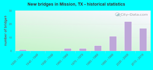
- New bridges - historical statistics
- 11930-1939
- 21960-1969
- 21970-1979
- 41980-1989
- 111990-1999
- 222000-2009
- 172010-2019
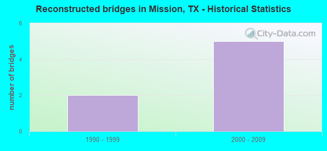
- Reconstructed bridges - Historical Statistics
- 21990-1999
- 52000-2009
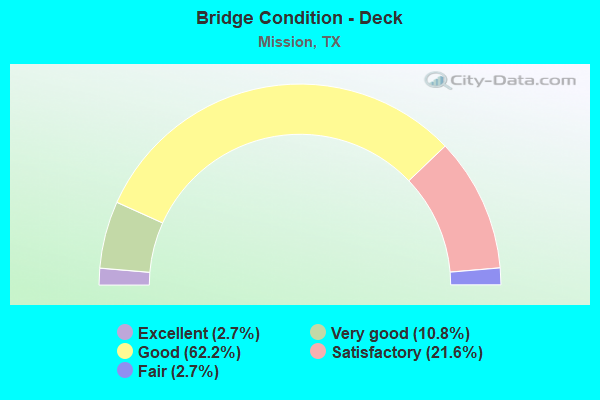
- Bridge Condition - Deck
- 2.7%Excellent
- 10.8%Very good
- 62.2%Good
- 21.6%Satisfactory
- 2.7%Fair
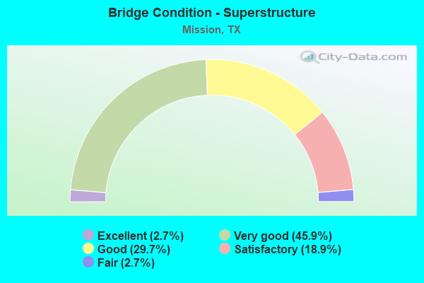
- Bridge Condition - Superstructure
- 2.7%Excellent
- 45.9%Very good
- 29.7%Good
- 18.9%Satisfactory
- 2.7%Fair
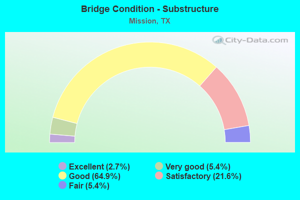
- Bridge Condition - Substructure
- 2.7%Excellent
- 5.4%Very good
- 64.9%Good
- 21.6%Satisfactory
- 5.4%Fair
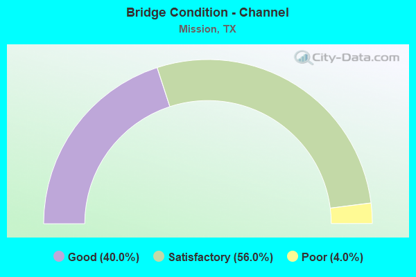
- Bridge Condition - Channel
- 40.0%Good
- 56.0%Satisfactory
- 4.0%Poor

- Bridge Condition - Culverts
- 60.0%Good
- 40.0%Satisfactory
Find on map >> Show street view
Structure Number: 211090M04423001, Location: 0.7 MI W OF SHARY RD (Lat: 26.184903, Lng: -98.301933), Route carried "on" structure: City street , Year Built: 1980, Status: Posted for load, Structure Length: 2.77m (9.09ft), Average Daily Traffic: 1,320 (year 2019), Truck Traffic: 1%, Average Future Daily Traffic: 500 (year 2031), Features Intersected: DRAINAGE DITCH, Facility Carried by Structure: RIO GRANDE DR
Minimum Vertical Clearance: 30+ m (98+ ft), Kilometerpoint: 1.127, Lanes on structure: 2, Owner: City or Municipal Highway Agency, Approaching Roadway Width: 7.9m (25.9ft), Material/Design: Concrete, Design/Construction: Stringer/Multi-beam, Number Of Spans In Main Unit: 3, Length of Maximum Span: 9.1m (29.9ft), Curb-To-Curb Width: 8.0m (26.2ft), Out-to-Out Width: 8.4m (27.6ft)
Condition: Deck: Good, Superstructure: Good, Substructure: Fair, Channel: Satisfactory, Operating Rating: 32.7 metric tons, Method Used To Determine Operating Rating: Field evaluation and documented engineering judgment, Inventory Rating: 24.5 metric tons, Method Used To Determine Inventory Rating: Field evaluation and documented engineering judgment, Structural Evaluation: Somewhat better than minimum adequacy, Deck Geometry: Meets minimum limits, Waterway Adequacy: Better than present minimum criteria, Approach Roadway Alignment: Equal to present desirable criteria, Bridge Posting: Required (Relationship of Operating Rating to Maximum Legal Load: 20.0 - 29.9% below), Designated Inspection Frequency: Every 24 months, Inspection Date: May 2020, Deck Structure Type: Concrete Cast-file-Place
Find on map >> Show street view
Structure Number: 211090003902163, Location: 0.50 MI S OF IH 2 (Lat: 26.191047, Lng: -98.313150), Route carried "under" structure: City street , Year Built: 2014, Structure Length: 0. m, Average Daily Traffic: 200 (year 2010), Truck Traffic: 15%, Features Intersected: TRINITY ST, Facility Carried by Structure: FM 396 NB
Minimum Vertical Clearance: 5.26m (17.26ft), Kilometerpoint: 0.000, Lanes on structure: 2, Lanes under structure: 5, Material/Design: Prestressed concrete, Design/Construction: Stringer/Multi-beam, Length of Maximum Span: 35.1m (115.2ft)
Find on map >> Show street view
Structure Number: 211090003902164, Location: 0.50 MI S OF US 83 (Lat: 26.191897, Lng: -98.313347), Route carried "under" structure: City street , Year Built: 2014, Structure Length: 0. m, Average Daily Traffic: 200 (year 2010), Truck Traffic: 15%, Features Intersected: TRINITY ST, Facility Carried by Structure: FM 396 SB
Minimum Vertical Clearance: 5.23m (17.16ft), Lanes on structure: 2, Lanes under structure: 5, Material/Design: Prestressed concrete, Design/Construction: Stringer/Multi-beam, Length of Maximum Span: 35.1m (115.2ft)
Find on map >> Show street view
Structure Number: 211090003917174, Location: 1.20 MI NW OF FM 1016 (Lat: 26.209958, Lng: -98.342994), Route carried "under" structure: US 83, Year Built: 1969, Structure Length: 0. m, Average Daily Traffic: 54,970 (year 2011), Truck Traffic: 9%, Features Intersected: US 83, Facility Carried by Structure: LOS EBANOS RD
Minimum Vertical Clearance: 5.36m (17.59ft), Kilometerpoint: 26.723, Lanes on structure: 2, Lanes under structure: 12, Material/Design: Steel continuous, Design/Construction: Stringer/Multi-beam, Length of Maximum Span: 29.6m (97.1ft)
Find on map >> Show street view
Structure Number: 211090003917321, Location: 1.00 MI W OF FM 396 (Lat: 26.201144, Lng: -98.328728), Route carried "under" structure: State highway 1016, Year Built: 2004, Structure Length: 0. m, Average Daily Traffic: 12,700 (year 2009), Truck Traffic: 3%, Features Intersected: FM 1016 & UP RR, Facility Carried by Structure: US 83 EB
Minimum Vertical Clearance: 7.47m (24.51ft), Kilometerpoint: 1.603, Lanes on structure: 4, Lanes under structure: 8, Material/Design: Prestressed concrete, Design/Construction: Stringer/Multi-beam, Length of Maximum Span: 33.8m (110.9ft)
Find on map >> Show street view
Structure Number: 211090003917322, Location: 1.00 MI W OF FM 396 (Lat: 26.201386, Lng: -98.327969), Route carried "under" structure: State highway 1016, Year Built: 2004, Structure Length: 0. m, Average Daily Traffic: 12,700 (year 2009), Truck Traffic: 3%, Features Intersected: FM 1016 & UP RR, Facility Carried by Structure: US 83 WB
Minimum Vertical Clearance: 7.60m (24.93ft), Kilometerpoint: 1.616, Lanes on structure: 4, Lanes under structure: 8, Material/Design: Prestressed concrete, Design/Construction: Stringer/Multi-beam, Length of Maximum Span: 33.8m (110.9ft)
Find on map >> Show street view
Structure Number: 211090003917323, Location: 1.50 MI W OF SP 487 (Lat: 26.195733, Lng: -98.288717), Route carried "under" structure: State highway 494, Year Built: 2004, Structure Length: 0. m, Average Daily Traffic: 17,300 (year 2009), Truck Traffic: 4%, Features Intersected: FM 494 (SHARY RD), Facility Carried by Structure: US 83 EB
Minimum Vertical Clearance: 5.31m (17.42ft), Kilometerpoint: 29.622, Lanes on structure: 4, Lanes under structure: 10, Material/Design: Prestressed concrete, Design/Construction: Stringer/Multi-beam, Length of Maximum Span: 33.8m (110.9ft)
Find on map >> Show street view
Structure Number: 211090003917324, Location: 1.50 MI W OF SP 487 (Lat: 26.195978, Lng: -98.288044), Route carried "under" structure: State highway 494, Year Built: 2004, Structure Length: 0. m, Average Daily Traffic: 17,300 (year 2009), Truck Traffic: 4%, Features Intersected: FM 494 (SHARY RD), Facility Carried by Structure: US 83 WB
Minimum Vertical Clearance: 5.39m (17.68ft), Kilometerpoint: 29.601, Lanes on structure: 4, Lanes under structure: 10, Material/Design: Prestressed concrete, Design/Construction: Stringer/Multi-beam, Length of Maximum Span: 33.8m (110.9ft)
Find on map >> Show street view
Structure Number: 211090003917428, Location: 1.00 MI E OF SH 107 (Lat: 26.199050, Lng: -98.312750), Route carried "under" structure: State highway 396, Year Built: 2014, Structure Length: 0. m, Average Daily Traffic: 19,200 (year 2009), Truck Traffic: 13%, Features Intersected: FM 396 (BRYAN RD), Facility Carried by Structure: US 83 EB
Minimum Vertical Clearance: 5.31m (17.42ft), Kilometerpoint: 1.645, Lanes on structure: 4, Lanes under structure: 8, Material/Design: Prestressed concrete, Design/Construction: Stringer/Multi-beam, Length of Maximum Span: 36.0m (118.1ft)
Find on map >> Show street view
Structure Number: 211090003917429, Location: 1.00 MI E OF SH 107 (Lat: 26.199017, Lng: -98.311450), Route carried "under" structure: State highway 396, Year Built: 2014, Structure Length: 0. m, Average Daily Traffic: 19,200 (year 2009), Truck Traffic: 13%, Features Intersected: FM 396 (BRYAN RD), Facility Carried by Structure: US 83 WB
Minimum Vertical Clearance: 5.31m (17.42ft), Kilometerpoint: 1.645, Lanes on structure: 4, Lanes under structure: 8, Material/Design: Prestressed concrete, Design/Construction: Stringer/Multi-beam, Length of Maximum Span: 36.0m (118.1ft)
Find on map >> Show street view
Structure Number: 211090003917436, Location: 1.8 MI NW of FM 1016 (Lat: 26.216175, Lng: -98.348350), Route carried "under" structure: State highway 83, Year Built: 2017, Structure Length: 0. m, Features Intersected: BUS 83 & RR
Minimum Vertical Clearance: 7.01m (23.00ft), Lanes on structure: 3, Lanes under structure: 12, Material/Design: Prestressed concrete, Design/Construction: Stringer/Multi-beam, Length of Maximum Span: 48.8m (160.1ft)
Find on map >> Show street view
Structure Number: 211090003917437, Location: 1.8 MI NW OF FM 1016 (Lat: 26.217086, Lng: -98.349542), Route carried "under" structure: State highway 83, Year Built: 2017, Structure Length: 0. m, Features Intersected: BUS 83 & RR
Minimum Vertical Clearance: 7.01m (23.00ft), Lanes on structure: 3, Lanes under structure: 12, Material/Design: Prestressed concrete, Design/Construction: Stringer/Multi-beam, Length of Maximum Span: 48.8m (160.1ft)
Find on map >> Show street view
Structure Number: 211090309702159, Location: 3.58 MI SE OF US 83 (Lat: 26.154739, Lng: -98.311967), Route carried "under" structure: County highway , Year Built: 2009, Structure Length: 0. m, Average Daily Traffic: 500 (year 2010), Truck Traffic: 3%, Features Intersected: UPRR & OLD MILITARY HWY, Facility Carried by Structure: FM 396 NB/BRYAN RD
Minimum Vertical Clearance: 6.99m (22.93ft), Kilometerpoint: 0.000, Lanes on structure: 2, Lanes under structure: 4, Material/Design: Prestressed concrete, Design/Construction: Stringer/Multi-beam, Length of Maximum Span: 34.7m (113.8ft)
Find on map >> Show street view
Structure Number: 21109030970216, Location: 3.58 MI SE OF US 83 (Lat: 26.153647, Lng: -98.312103), Route carried "under" structure: County highway , Year Built: 2009, Structure Length: 0. m, Average Daily Traffic: 500 (year 2010), Truck Traffic: 3%, Features Intersected: UPRR & OLD MILITARY HWY, Facility Carried by Structure: FM 396 SB/BRYAN RD
Minimum Vertical Clearance: 7.04m (23.10ft), Kilometerpoint: 0.000, Lanes on structure: 2, Lanes under structure: 4, Material/Design: Prestressed concrete, Design/Construction: Stringer/Multi-beam, Length of Maximum Span: 34.7m (113.8ft)
Find on map >> Show street view
Structure Number: 211090309702161, Location: 3.49 MI SE OF US 83 (Lat: 26.157828, Lng: -98.311264), Route carried "under" structure: State highway 1016, Year Built: 2009, Structure Length: 0. m, Average Daily Traffic: 2,500 (year 2010), Truck Traffic: 10%, Features Intersected: FM 1016, Facility Carried by Structure: FM 396 NB
Minimum Vertical Clearance: 5.92m (19.42ft), Kilometerpoint: 24.124, Lanes on structure: 2, Lanes under structure: 6, Material/Design: Prestressed concrete, Design/Construction: Stringer/Multi-beam, Length of Maximum Span: 40.8m (133.9ft)
Find on map >> Show street view
Structure Number: 211090309702162, Location: 3.49 MI SE OF US 83 (Lat: 26.158711, Lng: -98.311447), Route carried "under" structure: State highway 1016, Year Built: 2009, Structure Length: 0. m, Average Daily Traffic: 2,500 (year 2010), Truck Traffic: 10%, Features Intersected: FM 1016, Facility Carried by Structure: FM 396 SB
Minimum Vertical Clearance: 5.66m (18.57ft), Kilometerpoint: 24.100, Lanes on structure: 2, Lanes under structure: 6, Material/Design: Prestressed concrete, Design/Construction: Stringer/Multi-beam, Length of Maximum Span: 40.8m (133.9ft)
Find on map >> Show street view
Structure Number: 211090309702163, Location: 0.4 MI S OF US 83 (Lat: 26.191100, Lng: -98.313217), Route carried "under" structure: City street , Year Built: 2012, Structure Length: 0. m, Average Daily Traffic: 300 (year 2012), Truck Traffic: 1%, Features Intersected: TRINITY RD, Facility Carried by Structure: FM 396 NB
Minimum Vertical Clearance: 5.31m (17.42ft), Kilometerpoint: 0.000, Lanes on structure: 2, Lanes under structure: 4, Material/Design: Prestressed concrete, Design/Construction: Stringer/Multi-beam, Length of Maximum Span: 35.1m (115.2ft)
Find on map >> Show street view
Structure Number: 211090309702164, Location: 0.4 MI S OF US 83 (Lat: 26.191967, Lng: -98.313333), Route carried "under" structure: City street , Year Built: 2012, Structure Length: 0. m, Average Daily Traffic: 300 (year 2012), Truck Traffic: 1%, Features Intersected: TRINITY RD, Facility Carried by Structure: FM 396 SB
Minimum Vertical Clearance: 5.18m (16.99ft), Kilometerpoint: 0.000, Lanes on structure: 2, Lanes under structure: 4, Material/Design: Prestressed concrete, Design/Construction: Stringer/Multi-beam, Length of Maximum Span: 35.1m (115.2ft)