Bridge Statistics for Morrisville, North Carolina (NC)
Condition, Traffic, Stress, Structural Evaluation, Project Costs
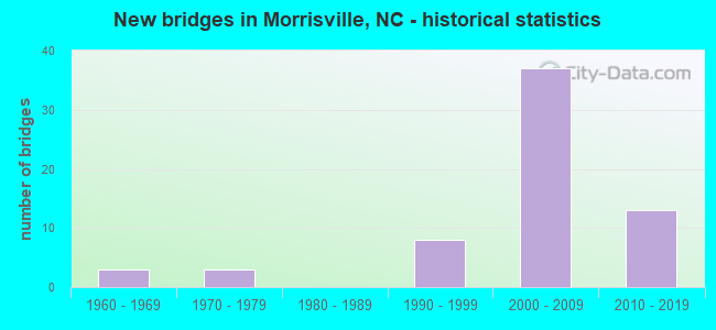
- New bridges - historical statistics
- 31960-1969
- 31970-1979
- 81990-1999
- 372000-2009
- 132010-2019
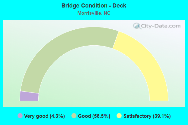
- Bridge Condition - Deck
- 4.3%Very good
- 56.5%Good
- 39.1%Satisfactory
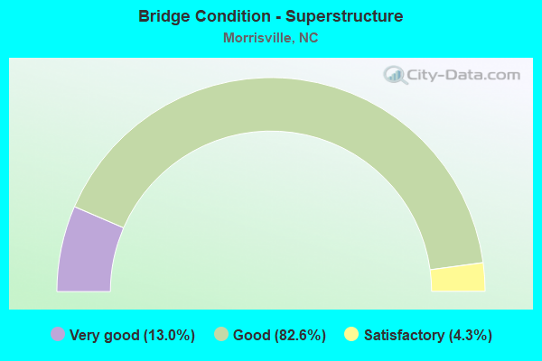
- Bridge Condition - Superstructure
- 13.0%Very good
- 82.6%Good
- 4.3%Satisfactory
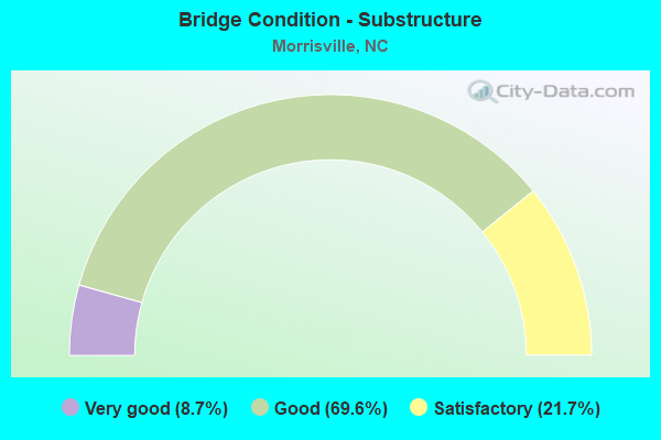
- Bridge Condition - Substructure
- 8.7%Very good
- 69.6%Good
- 21.7%Satisfactory
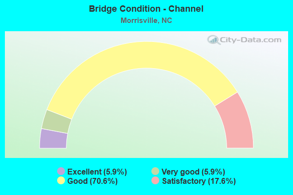
- Bridge Condition - Channel
- 5.9%Excellent
- 5.9%Very good
- 70.6%Good
- 17.6%Satisfactory
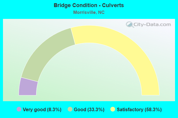
- Bridge Condition - Culverts
- 8.3%Very good
- 33.3%Good
- 58.3%Satisfactory
Find on map >> Show street view
Structure Number: 110005, Location: .2 MI.N.JCT.SR1138 (Lat: 36.065775, Lng: -82.000728), Route carried "on" structure: State highway 1121, Year Built: 1966, Status: Open, Structure Length: 5.27m (17.29ft), Average Daily Traffic: 1,000 (year 2012), Truck Traffic: 6%, Average Future Daily Traffic: 2,000 (year 2040), Design Load: H 15, Features Intersected: NORTH TOE RIVER
Minimum Vertical Clearance: 30+ m (98+ ft), Kilometerpoint: 0.000, Lanes on structure: 2, Owner: State Highway Agency, Approaching Roadway Width: 6.7m (22.0ft), Skew: 3 degrees, Material/Design: Steel, Design/Construction: Stringer/Multi-beam, Number Of Spans In Main Unit: 3, Length of Maximum Span: 17.3m (56.8ft), Curb-To-Curb Width: 9.1m (29.9ft), Out-to-Out Width: 9.9m (32.5ft)
Condition: Deck: Good, Superstructure: Satisfactory, Substructure: Satisfactory, Channel: Good, Operating Rating: 48.9 metric tons, Method Used To Determine Operating Rating: Load Factor (LF), Inventory Rating: 29.0 metric tons, Method Used To Determine Inventory Rating: Load Factor (LF), Structural Evaluation: Equal to present minimum criteria, Deck Geometry: Equal to present minimum criteria, Waterway Adequacy: Better than present minimum criteria, Approach Roadway Alignment: Equal to present desirable criteria, Designated Inspection Frequency: Every 24 months, Underwater Inspection Frequency: Every 60 months, Inspection Date: May 2021, Underwater Inspection Date: April 2020, Deck Structure Type: Concrete Cast-file-Place, Wearing Surface/Protective System: Wearing Surface: Latex Concrete
Find on map >> Show street view
Structure Number: 630587, Location: 0.42 MI. S. JCT. SR1978 (Lat: 35.870608, Lng: -78.865736), Route carried "on" structure: State highway 147, Year Built: 2011, Status: Open, Structure Length: 4.45m (14.60ft), Average Daily Traffic: 8,500 (year 2017), Truck Traffic: 12%, Average Future Daily Traffic: 17,000 (year 2040), Design Load: HL 93, Features Intersected: SR 1999
Minimum Vertical Clearance: 30+ m (98+ ft), Kilometerpoint: 0.000, Lanes on structure: 3, Lanes under structure: 7, Base Highway Network: Yes (Inventory Route: 3, Subroute: 47), Toll: On toll road, Owner: State Toll Authority, Approaching Roadway Width: 18.8m (61.7ft), Skew: 11 degrees, Material/Design: Prestressed concrete continuous, Design/Construction: Stringer/Multi-beam, Number Of Spans In Main Unit: 1, Length of Maximum Span: 42.6m (139.8ft), Curb-To-Curb Width: 18.2m (59.7ft), Out-to-Out Width: 19.4m (63.6ft)
Condition: Deck: Good, Superstructure: Good, Substructure: Good, Operating Rating: 76.2 metric tons, Method Used To Determine Operating Rating: Load and Resistance Factor (LRFR), Inventory Rating: 49.8 metric tons, Method Used To Determine Inventory Rating: Load and Resistance Factor (LRFR), Structural Evaluation: Better than present minimum criteria, Deck Geometry: Superior to present desirable criteria, Underclear: Equal to present minimum criteria, Approach Roadway Alignment: Equal to present desirable criteria, Designated Inspection Frequency: Every 24 months, Inspection Date: July 2020, Deck Structure Type: Concrete Cast-file-Place, Wearing Surface/Protective System: Wearing Surface: Monolithic Concrete, Deck Protection: Epoxy Coated Reinforcing
Find on map >> Show street view
Structure Number: 630588, Location: JCT. OF NC147 & SR1999 (Lat: 35.870697, Lng: -78.865472), Route carried "on" structure: State highway 147, Year Built: 2011, Status: Open, Structure Length: 4.45m (14.60ft), Average Daily Traffic: 8,500 (year 2017), Truck Traffic: 14%, Average Future Daily Traffic: 17,000 (year 2040), Design Load: HL 93, Features Intersected: SR1999
Minimum Vertical Clearance: 30+ m (98+ ft), Kilometerpoint: 0.000, Lanes on structure: 3, Lanes under structure: 7, Base Highway Network: Yes (Inventory Route: 3, Subroute: 47), Toll: On toll road, Owner: State Toll Authority, Approaching Roadway Width: 18.5m (60.7ft), Skew: 11 degrees, Material/Design: Prestressed concrete, Design/Construction: Stringer/Multi-beam, Number Of Spans In Main Unit: 1, Length of Maximum Span: 42.6m (139.8ft), Curb-To-Curb Width: 18.2m (59.7ft), Out-to-Out Width: 19.4m (63.6ft)
Condition: Deck: Good, Superstructure: Good, Substructure: Good, Operating Rating: 76.2 metric tons, Method Used To Determine Operating Rating: Load and Resistance Factor (LRFR), Inventory Rating: 49.8 metric tons, Method Used To Determine Inventory Rating: Load and Resistance Factor (LRFR), Structural Evaluation: Better than present minimum criteria, Deck Geometry: Superior to present desirable criteria, Underclear: Equal to present minimum criteria, Approach Roadway Alignment: Equal to present desirable criteria, Designated Inspection Frequency: Every 24 months, Inspection Date: July 2020, Deck Structure Type: Concrete Cast-file-Place, Wearing Surface/Protective System: Wearing Surface: Monolithic Concrete, Deck Protection: Epoxy Coated Reinforcing
Find on map >> Show street view
Structure Number: 970552, Location: 0.4 MI. E. JCT. NC801 (Lat: 35.607128, Lng: -80.785814), Route carried "on" structure: State highway 150, Year Built: 1974, Status: Open, Structure Length: 0.85m (2.79ft), Average Daily Traffic: 15,500 (year 2018), Truck Traffic: 12%, Average Future Daily Traffic: 31,000 (year 2040), Design Load: HS 20+Mod, Features Intersected: BACK CREEK
Minimum Vertical Clearance: 30+ m (98+ ft), Kilometerpoint: 0.000, Lanes on structure: 2, Base Highway Network: Yes (Inventory Route: 3, Subroute: 50), Owner: State Highway Agency, Approaching Roadway Width: 7.0m (23.0ft), Material/Design: Concrete continuous, Design/Construction: Culvert, Number Of Spans In Main Unit: 3, Length of Maximum Span: 2.7m (8.9ft)
Condition: Channel: Good, Culverts: Satisfactory, Operating Rating: 41.7 metric tons, Method Used To Determine Operating Rating: Field evaluation and documented engineering judgment, Inventory Rating: 32.6 metric tons, Method Used To Determine Inventory Rating: Field evaluation and documented engineering judgment, Structural Evaluation: Equal to present minimum criteria, Waterway Adequacy: Better than present minimum criteria, Approach Roadway Alignment: Equal to present desirable criteria, Designated Inspection Frequency: Every 24 months, Inspection Date: Febuary 2022
Find on map >> Show street view
Structure Number: 1830054, Location: 0.7 MI. W. JCT. SR1002 (Lat: 35.857603, Lng: -78.809467), Route carried "on" structure: Interstate 40, Year Built: 1970, Status: Open, Structure Length: 0.97m (3.18ft), Average Daily Traffic: 156,000 (year 2017), Truck Traffic: 16%, Average Future Daily Traffic: 312,000 (year 2040), Design Load: HS 20+Mod, Features Intersected: BRIER CREEK
Minimum Vertical Clearance: 30+ m (98+ ft), Kilometerpoint: 86.564, Lanes on structure: 8, Base Highway Network: Yes (Inventory Route: 1, Subroute: 40), Owner: State Highway Agency, Approaching Roadway Width: 45.7m (149.9ft), Skew: 33 degrees, Material/Design: Concrete continuous, Design/Construction: Culvert, Number Of Spans In Main Unit: 3, Length of Maximum Span: 2.7m (8.9ft)
Condition: Channel: Good, Culverts: Satisfactory, Operating Rating: 44.4 metric tons, Method Used To Determine Operating Rating: Load Factor (LF), Inventory Rating: 26.3 metric tons, Method Used To Determine Inventory Rating: Load Factor (LF), Structural Evaluation: Equal to present minimum criteria, Waterway Adequacy: Better than present minimum criteria, Approach Roadway Alignment: Equal to present desirable criteria, Designated Inspection Frequency: Every 24 months, Underwater Inspection Frequency: Every 60 months, Inspection Date: May 2021, Underwater Inspection Date: May 2021
Find on map >> Show street view
Structure Number: 1830064, Location: 0.2MI.S.SR3014 (Lat: 35.817883, Lng: -78.847706), Route carried "on" structure: State highway 1613, Year Built: 1997, Status: Open, Structure Length: 0.64m (2.10ft), Average Daily Traffic: 31,000 (year 2019), Truck Traffic: 6%, Average Future Daily Traffic: 62,000 (year 2040), Design Load: HS 20+Mod, Features Intersected: CRABTREE CREEK
Minimum Vertical Clearance: 30+ m (98+ ft), Kilometerpoint: 0.000, Lanes on structure: 5, Owner: State Highway Agency, Approaching Roadway Width: 20.7m (67.9ft), Skew: 1 degrees, Material/Design: Steel, Design/Construction: Culvert, Number Of Spans In Main Unit: 2, Length of Maximum Span: 2.7m (8.9ft)
Condition: Channel: Good, Culverts: Good, Operating Rating: 89.8 metric tons, Method Used To Determine Operating Rating: Load and Resistance Factor (LRFR), Inventory Rating: 89.8 metric tons, Method Used To Determine Inventory Rating: Load and Resistance Factor (LRFR), Structural Evaluation: Better than present minimum criteria, Waterway Adequacy: Better than present minimum criteria, Approach Roadway Alignment: Equal to present desirable criteria, Designated Inspection Frequency: Every 24 months, Inspection Date: September 2021
Find on map >> Show street view
Structure Number: 1830506, Location: 0.2 MI. S. JCT. I40 (Lat: 35.859847, Lng: -78.818042), Route carried "on" structure: State highway 3015, Year Built: 1971, Status: Open, Structure Length: 0.97m (3.18ft), Average Daily Traffic: 34,500 (year 2019), Truck Traffic: 7%, Average Future Daily Traffic: 69,000 (year 2040), Design Load: HS 20+Mod, Features Intersected: STIRRUP IRON CREEK
Minimum Vertical Clearance: 30+ m (98+ ft), Kilometerpoint: 0.000, Lanes on structure: 6, Owner: State Highway Agency, Approaching Roadway Width: 23.4m (76.8ft), Material/Design: Concrete continuous, Design/Construction: Culvert, Number Of Spans In Main Unit: 3, Length of Maximum Span: 3.0m (9.8ft)
Condition: Channel: Satisfactory, Culverts: Satisfactory, Operating Rating: 48.0 metric tons, Method Used To Determine Operating Rating: Load and Resistance Factor (LRFR), Inventory Rating: 37.1 metric tons, Method Used To Determine Inventory Rating: Load and Resistance Factor (LRFR), Structural Evaluation: Equal to present minimum criteria, Waterway Adequacy: Better than present minimum criteria, Approach Roadway Alignment: Equal to present desirable criteria, Designated Inspection Frequency: Every 24 months, Inspection Date: September 2021
Find on map >> Show street view
Structure Number: 1830693, Location: 0.68 MI.W.JCT.SR1644 (Lat: 35.895175, Lng: -78.791431), Route carried "on" structure: Interstate 540, Year Built: 1996, Status: Open, Structure Length: 1.55m (5.09ft), Average Daily Traffic: 109,000 (year 2019), Truck Traffic: 16%, Average Future Daily Traffic: 218,000 (year 2040), Design Load: HS 20+Mod, Features Intersected: LITTLE BRIAR CRK.
Minimum Vertical Clearance: 30+ m (98+ ft), Kilometerpoint: 0.853, Lanes on structure: 9, Base Highway Network: Yes (Inventory Route: 1, Subroute: 40), Owner: State Highway Agency, Approaching Roadway Width: 46.3m (151.9ft), Skew: 1 degrees, Material/Design: Concrete continuous, Design/Construction: Culvert, Number Of Spans In Main Unit: 4, Length of Maximum Span: 3.6m (11.8ft)
Condition: Channel: Satisfactory, Culverts: Satisfactory, Operating Rating: 89.8 metric tons, Method Used To Determine Operating Rating: Load and Resistance Factor (LRFR), Inventory Rating: 89.8 metric tons, Method Used To Determine Inventory Rating: Load and Resistance Factor (LRFR), Structural Evaluation: Equal to present minimum criteria, Waterway Adequacy: Better than present minimum criteria, Approach Roadway Alignment: Equal to present desirable criteria, Designated Inspection Frequency: Every 24 months, Inspection Date: September 2021
Find on map >> Show street view
Structure Number: 1830754, Location: 0.9 MI.S.JCT.SR1390 (Lat: 35.652933, Lng: -78.787589), Route carried "on" structure: State highway 1301, Year Built: 1997, Status: Open, Structure Length: 4.48m (14.70ft), Average Daily Traffic: 12,000 (year 2018), Truck Traffic: 7%, Average Future Daily Traffic: 24,000 (year 2040), Design Load: HS 20+Mod, Features Intersected: MIDDLE CREEK
Minimum Vertical Clearance: 30+ m (98+ ft), Kilometerpoint: 0.000, Lanes on structure: 2, Owner: State Highway Agency, Approaching Roadway Width: 9.4m (30.8ft), Skew: 2 degrees, Material/Design: Prestressed concrete continuous, Design/Construction: Stringer/Multi-beam, Number Of Spans In Main Unit: 3, Length of Maximum Span: 19.5m (64.0ft), Curb-To-Curb Width: 9.1m (29.9ft), Out-to-Out Width: 10.2m (33.5ft)
Condition: Deck: Very good, Superstructure: Good, Substructure: Good, Channel: Good, Operating Rating: 76.2 metric tons, Method Used To Determine Operating Rating: Load Factor (LF), Inventory Rating: 45.3 metric tons, Method Used To Determine Inventory Rating: Load Factor (LF), Structural Evaluation: Better than present minimum criteria, Deck Geometry: High priority of corrective action, Waterway Adequacy: Better than present minimum criteria, Approach Roadway Alignment: Equal to present desirable criteria, Designated Inspection Frequency: Every 24 months, Inspection Date: July 2021, Deck Structure Type: Concrete Cast-file-Place, Wearing Surface/Protective System: Wearing Surface: Integral Concrete, Deck Protection: Epoxy Coated Reinforcing
Find on map >> Show street view
Structure Number: 1830759, Location: .7 MI. S. SR1644 GLOBE RD (Lat: 35.891700, Lng: -78.813931), Route carried "on" structure: State highway 3097, Year Built: 1998, Status: Open, Structure Length: 11.97m (39.27ft), Average Daily Traffic: 9,500 (year 2017), Truck Traffic: 12%, Average Future Daily Traffic: 19,000 (year 2040), Design Load: HS 20+Mod, Features Intersected: I540
Minimum Vertical Clearance: 30+ m (98+ ft), Kilometerpoint: 0.487, Lanes on structure: 3, Lanes under structure: 9, Base Highway Network: Yes, Owner: State Highway Agency, Approaching Roadway Width: 11.2m (36.7ft), Skew: 10 degrees, Material/Design: Steel continuous, Design/Construction: Stringer/Multi-beam, Number Of Spans In Main Unit: 3, Length of Maximum Span: 43.8m (143.7ft), Curb-To-Curb Width: 14.0m (45.9ft), Out-to-Out Width: 14.9m (48.9ft)
Condition: Deck: Good, Superstructure: Good, Substructure: Good, Operating Rating: 43.5 metric tons, Method Used To Determine Operating Rating: Load Factor (LF), Inventory Rating: 25.4 metric tons, Method Used To Determine Inventory Rating: Load Factor (LF), Structural Evaluation: Equal to present minimum criteria, Deck Geometry: Somewhat better than minimum adequacy, Underclear: High priority of corrective action, Approach Roadway Alignment: Equal to present desirable criteria, Designated Inspection Frequency: Every 24 months, Inspection Date: January 2022, Deck Structure Type: Concrete Cast-file-Place, Wearing Surface/Protective System: Wearing Surface: Monolithic Concrete, Deck Protection: Epoxy Coated Reinforcing
Find on map >> Show street view
Structure Number: 183104, Location: 0.1 MI. N. JCT. SR4413 (Lat: 35.861833, Lng: -78.548867), Route carried "on" structure: US 401, Year Built: 2001, Status: Open, Structure Length: 5.54m (18.18ft), Average Daily Traffic: 41,000 (year 2017), Truck Traffic: 12%, Average Future Daily Traffic: 82,000 (year 2040), Design Load: HS 20+Mod, Features Intersected: I540
Minimum Vertical Clearance: 30+ m (98+ ft), Kilometerpoint: 0.000, Lanes on structure: 6, Lanes under structure: 6, Base Highway Network: Yes (Inventory Route: 2, Subroute: 1), Owner: State Highway Agency, Approaching Roadway Width: 37.1m (121.7ft), Skew: 1 degrees, Material/Design: Prestressed concrete continuous, Design/Construction: Stringer/Multi-beam, Number Of Spans In Main Unit: 2, Length of Maximum Span: 26.5m (86.9ft), Curb or Sidewalk Widths: Left: 7.9m (25.9ft), Right: 8.0m (26.2ft), Curb-To-Curb Width: 41.6m (136.5ft), Out-to-Out Width: 71.4m (234.3ft)
Condition: Deck: Good, Superstructure: Good, Substructure: Good, Operating Rating: 72.5 metric tons, Method Used To Determine Operating Rating: Load Factor (LF), Inventory Rating: 31.7 metric tons, Method Used To Determine Inventory Rating: Load Factor (LF), Structural Evaluation: Better than present minimum criteria, Deck Geometry: Superior to present desirable criteria, Underclear: Equal to present minimum criteria, Approach Roadway Alignment: Equal to present desirable criteria, Designated Inspection Frequency: Every 24 months, Inspection Date: May 2020, Deck Structure Type: Concrete Cast-file-Place, Wearing Surface/Protective System: Wearing Surface: Monolithic Concrete, Deck Protection: Epoxy Coated Reinforcing
Find on map >> Show street view
Structure Number: 1831043, Location: 0.36 MI.W.JCT.NC540W;SR54 (Lat: 35.861375, Lng: -78.845433), Route carried "on" structure: Interstate 540, Year Built: 2007, Status: Open, Structure Length: 13.35m (43.80ft), Average Daily Traffic: 23,500 (year 2019), Truck Traffic: 12%, Average Future Daily Traffic: 47,000 (year 2040), Design Load: HS 20+Mod, Features Intersected: NC54;SR1637, SO.RR
Minimum Vertical Clearance: 30+ m (98+ ft), Kilometerpoint: 20.970, Lanes on structure: 4, Lanes under structure: 8, Base Highway Network: Yes (Inventory Route: 1, Subroute: 40), Owner: State Highway Agency, Approaching Roadway Width: 22.2m (72.8ft), Skew: 1 degrees, Material/Design: Steel continuous, Design/Construction: Stringer/Multi-beam, Number Of Spans In Main Unit: 3, Length of Maximum Span: 49.0m (160.8ft), Curb-To-Curb Width: 21.5m (70.5ft), Out-to-Out Width: 22.5m (73.8ft)
Condition: Deck: Satisfactory, Superstructure: Good, Substructure: Good, Operating Rating: 89.8 metric tons, Method Used To Determine Operating Rating: Load Factor (LF), Inventory Rating: 57.1 metric tons, Method Used To Determine Inventory Rating: Load Factor (LF), Structural Evaluation: Better than present minimum criteria, Deck Geometry: Better than present minimum criteria, Underclear: Equal to present minimum criteria, Approach Roadway Alignment: Equal to present desirable criteria, Designated Inspection Frequency: Every 24 months, Inspection Date: November 2021, Deck Structure Type: Concrete Cast-file-Place, Wearing Surface/Protective System: Wearing Surface: Monolithic Concrete
Find on map >> Show street view
Structure Number: 1831044, Location: 0.1 MI.E.JCT.NC540E;SR54 (Lat: 35.861139, Lng: -78.845261), Route carried "on" structure: Interstate 540, Year Built: 2007, Status: Open, Structure Length: 13.22m (43.37ft), Average Daily Traffic: 23,500 (year 2019), Truck Traffic: 16%, Average Future Daily Traffic: 47,000 (year 2040), Design Load: HS 20+Mod, Features Intersected: NC54,SR1637, SO. R/R
Minimum Vertical Clearance: 30+ m (98+ ft), Kilometerpoint: 20.970, Lanes on structure: 4, Lanes under structure: 6, Base Highway Network: Yes (Inventory Route: 1, Subroute: 40), Owner: State Highway Agency, Approaching Roadway Width: 21.6m (70.9ft), Skew: 1 degrees, Material/Design: Steel continuous, Design/Construction: Stringer/Multi-beam, Number Of Spans In Main Unit: 3, Length of Maximum Span: 49.0m (160.8ft), Curb-To-Curb Width: 21.5m (70.5ft), Out-to-Out Width: 22.5m (73.8ft)
Condition: Deck: Satisfactory, Superstructure: Good, Substructure: Good, Operating Rating: 89.8 metric tons, Method Used To Determine Operating Rating: Load Factor (LF), Inventory Rating: 57.1 metric tons, Method Used To Determine Inventory Rating: Load Factor (LF), Structural Evaluation: Better than present minimum criteria, Deck Geometry: Better than present minimum criteria, Underclear: Equal to present minimum criteria, Approach Roadway Alignment: Equal to present desirable criteria, Designated Inspection Frequency: Every 24 months, Inspection Date: November 2021, Deck Structure Type: Concrete Cast-file-Place, Wearing Surface/Protective System: Wearing Surface: Monolithic Concrete
Find on map >> Show street view
Structure Number: 1831045, Location: 0.64 MI.N.JCT.NC540;SR147 (Lat: 35.856122, Lng: -78.858008), Route carried "on" structure: Ramp State highway 540, Year Built: 2007, Status: Open, Structure Length: 21.03m (69.00ft), Average Daily Traffic: 11,625 (year 2019), Truck Traffic: 12%, Average Future Daily Traffic: 23,250 (year 2040), Design Load: HS 20+Mod, Features Intersected: NC540N;RMP
Minimum Vertical Clearance: 30+ m (98+ ft), Kilometerpoint: 0.000, Lanes on structure: 2, Lanes under structure: 8, Toll: On toll road, Owner: State Highway Agency, Approaching Roadway Width: 12.4m (40.7ft), Material/Design: Steel continuous, Design/Construction: Stringer/Multi-beam, Number Of Spans In Main Unit: 4, Length of Maximum Span: 60.6m (198.8ft), Curb-To-Curb Width: 11.9m (39.0ft), Out-to-Out Width: 12.9m (42.3ft)
Condition: Deck: Satisfactory, Superstructure: Good, Substructure: Satisfactory, Operating Rating: 69.8 metric tons, Method Used To Determine Operating Rating: Load Factor (LF), Inventory Rating: 41.7 metric tons, Method Used To Determine Inventory Rating: Load Factor (LF), Structural Evaluation: Equal to present minimum criteria, Deck Geometry: Superior to present desirable criteria, Underclear: Better than present minimum criteria, Approach Roadway Alignment: Equal to present desirable criteria, Designated Inspection Frequency: Every 24 months, Inspection Date: November 2021, Deck Structure Type: Concrete Cast-file-Place, Wearing Surface/Protective System: Wearing Surface: Monolithic Concrete, Deck Protection: Epoxy Coated Reinforcing
Find on map >> Show street view
Structure Number: 1831046, Location: .34 MI N OF SR147 RAMP (Lat: 35.853831, Lng: -78.858461), Route carried "on" structure: Ramp State highway 540, Year Built: 2007, Status: Open, Structure Length: 10.18m (33.40ft), Average Daily Traffic: 9,125 (year 2019), Truck Traffic: 12%, Average Future Daily Traffic: 18,250 (year 2040), Design Load: HS 20+Mod, Features Intersected: DIRT
Minimum Vertical Clearance: 30+ m (98+ ft), Kilometerpoint: 20.726, Lanes on structure: 2, Base Highway Network: Yes, Toll: On toll road, Owner: State Highway Agency, Approaching Roadway Width: 12.4m (40.7ft), Material/Design: Steel continuous, Design/Construction: Stringer/Multi-beam, Number Of Spans In Main Unit: 3, Length of Maximum Span: 42.3m (138.8ft), Curb-To-Curb Width: 12.0m (39.4ft), Out-to-Out Width: 12.9m (42.3ft)
Condition: Deck: Satisfactory, Superstructure: Good, Substructure: Satisfactory, Operating Rating: 45.3 metric tons, Method Used To Determine Operating Rating: Load Factor (LF), Inventory Rating: 27.2 metric tons, Method Used To Determine Inventory Rating: Load Factor (LF), Structural Evaluation: Equal to present minimum criteria, Deck Geometry: Superior to present desirable criteria, Approach Roadway Alignment: Equal to present desirable criteria, Designated Inspection Frequency: Every 24 months, Inspection Date: November 2021, Deck Structure Type: Concrete Cast-file-Place, Wearing Surface/Protective System: Wearing Surface: Monolithic Concrete, Deck Protection: Epoxy Coated Reinforcing
Find on map >> Show street view
Structure Number: 1831047, Location: 0.44 MI. N. NC540E RMP (Lat: 35.853181, Lng: -78.857861), Route carried "on" structure: Ramp State highway 540, Year Built: 2007, Status: Open, Structure Length: 10.14m (33.27ft), Average Daily Traffic: 11,625 (year 2019), Truck Traffic: 12%, Average Future Daily Traffic: 23,250 (year 2040), Design Load: HS 20+Mod, Features Intersected: DIRT
Minimum Vertical Clearance: 30+ m (98+ ft), Kilometerpoint: 0.000, Lanes on structure: 2, Owner: State Highway Agency, Approaching Roadway Width: 12.4m (40.7ft), Material/Design: Steel continuous, Design/Construction: Stringer/Multi-beam, Number Of Spans In Main Unit: 2, Length of Maximum Span: 56.9m (186.7ft), Curb-To-Curb Width: 12.0m (39.4ft), Out-to-Out Width: 12.9m (42.3ft)
Condition: Deck: Satisfactory, Superstructure: Good, Substructure: Satisfactory, Operating Rating: 66.2 metric tons, Method Used To Determine Operating Rating: Load Factor (LF), Inventory Rating: 39.0 metric tons, Method Used To Determine Inventory Rating: Load Factor (LF), Structural Evaluation: Equal to present minimum criteria, Deck Geometry: Superior to present desirable criteria, Approach Roadway Alignment: Equal to present desirable criteria, Designated Inspection Frequency: Every 24 months, Inspection Date: November 2021, Deck Structure Type: Concrete Cast-file-Place, Wearing Surface/Protective System: Wearing Surface: Monolithic Concrete, Deck Protection: Epoxy Coated Reinforcing
Find on map >> Show street view
Structure Number: 1831048, Location: @JCT.NC540 (Lat: 35.853003, Lng: -78.861272), Route carried "on" structure: Ramp State highway 540, Year Built: 2007, Status: Open, Structure Length: 10.85m (35.60ft), Average Daily Traffic: 10,250 (year 2019), Truck Traffic: 12%, Average Future Daily Traffic: 20,500 (year 2040), Design Load: HS 20+Mod, Features Intersected: NC540
Minimum Vertical Clearance: 30+ m (98+ ft), Kilometerpoint: 20.665, Lanes on structure: 2, Lanes under structure: 6, Toll: On toll road, Owner: State Highway Agency, Approaching Roadway Width: 12.8m (42.0ft), Skew: 1 degrees, Material/Design: Steel continuous, Design/Construction: Stringer/Multi-beam, Number Of Spans In Main Unit: 3, Length of Maximum Span: 48.4m (158.8ft), Curb-To-Curb Width: 12.0m (39.4ft), Out-to-Out Width: 12.9m (42.3ft)
Condition: Deck: Satisfactory, Superstructure: Good, Substructure: Satisfactory, Operating Rating: 51.7 metric tons, Method Used To Determine Operating Rating: Load Factor (LF), Inventory Rating: 30.8 metric tons, Method Used To Determine Inventory Rating: Load Factor (LF), Structural Evaluation: Equal to present minimum criteria, Deck Geometry: Superior to present desirable criteria, Underclear: Equal to present minimum criteria, Approach Roadway Alignment: Equal to present desirable criteria, Designated Inspection Frequency: Every 24 months, Inspection Date: November 2021, Deck Structure Type: Concrete Cast-file-Place, Wearing Surface/Protective System: Wearing Surface: Monolithic Concrete, Deck Protection: Epoxy Coated Reinforcing
Find on map >> Show street view
Structure Number: 1831049, Location: 1.5 MI. E. JCT. NC55 (Lat: 35.851042, Lng: -78.862142), Route carried "on" structure: Ramp State highway 540, Year Built: 2007, Status: Open, Structure Length: 6.55m (21.49ft), Average Daily Traffic: 11,125 (year 2018), Truck Traffic: 12%, Average Future Daily Traffic: 22,250 (year 2040), Design Load: HS 20+Mod, Features Intersected: SR1613
Minimum Vertical Clearance: 30+ m (98+ ft), Kilometerpoint: 0.000, Lanes on structure: 2, Lanes under structure: 4, Owner: State Highway Agency, Approaching Roadway Width: 13.1m (43.0ft), Skew: 2 degrees, Material/Design: Prestressed concrete continuous, Design/Construction: Stringer/Multi-beam, Number Of Spans In Main Unit: 2, Length of Maximum Span: 33.5m (109.9ft), Curb-To-Curb Width: 12.0m (39.4ft), Out-to-Out Width: 12.8m (42.0ft)
Condition: Deck: Good, Superstructure: Good, Substructure: Good, Operating Rating: 68.9 metric tons, Method Used To Determine Operating Rating: Load Factor (LF), Inventory Rating: 30.8 metric tons, Method Used To Determine Inventory Rating: Load Factor (LF), Structural Evaluation: Better than present minimum criteria, Deck Geometry: High priority of corrective action, Underclear: Somewhat better than minimum adequacy, Approach Roadway Alignment: Equal to present desirable criteria, Designated Inspection Frequency: Every 24 months, Inspection Date: May 2020, Deck Structure Type: Concrete Cast-file-Place, Wearing Surface/Protective System: Wearing Surface: Monolithic Concrete, Deck Protection: Epoxy Coated Reinforcing
Find on map >> Show street view
Structure Number: 183105, Location: 1.2 MI. W. JCT. NC54 (Lat: 35.851617, Lng: -78.863119), Route carried "on" structure: Interstate 540, Year Built: 2007, Status: Open, Structure Length: 5.39m (17.68ft), Average Daily Traffic: 22,250 (year 2018), Truck Traffic: 12%, Average Future Daily Traffic: 44,500 (year 2040), Design Load: HS 20+Mod, Features Intersected: SR1613
Minimum Vertical Clearance: 30+ m (98+ ft), Kilometerpoint: 0.000, Lanes on structure: 3, Lanes under structure: 4, Base Highway Network: Yes (Inventory Route: 1, Subroute: 40), Owner: State Highway Agency, Approaching Roadway Width: 18.2m (59.7ft), Skew: 10 degrees, Material/Design: Prestressed concrete continuous, Design/Construction: Stringer/Multi-beam, Number Of Spans In Main Unit: 2, Length of Maximum Span: 26.2m (86.0ft), Curb-To-Curb Width: 18.0m (59.1ft), Out-to-Out Width: 18.9m (62.0ft)
Condition: Deck: Good, Superstructure: Good, Substructure: Good, Operating Rating: 87.9 metric tons, Method Used To Determine Operating Rating: Load Factor (LF), Inventory Rating: 49.8 metric tons, Method Used To Determine Inventory Rating: Load Factor (LF), Structural Evaluation: Better than present minimum criteria, Deck Geometry: High priority of corrective action, Underclear: High priority of corrective action, Approach Roadway Alignment: Equal to present desirable criteria, Designated Inspection Frequency: Every 24 months, Inspection Date: May 2020, Deck Structure Type: Concrete Cast-file-Place, Wearing Surface/Protective System: Wearing Surface: Monolithic Concrete, Deck Protection: Epoxy Coated Reinforcing
Find on map >> Show street view
Structure Number: 1831051, Location: 1.2 MI.S.NC54 (Lat: 35.851450, Lng: -78.862833), Route carried "on" structure: Interstate 540, Year Built: 2007, Status: Open, Structure Length: 5.39m (17.68ft), Average Daily Traffic: 22,250 (year 2018), Truck Traffic: 16%, Average Future Daily Traffic: 44,500 (year 2040), Design Load: HS 20+Mod, Features Intersected: SR1613(DAVIS DRIVE)
Minimum Vertical Clearance: 30+ m (98+ ft), Kilometerpoint: 0.000, Lanes on structure: 3, Lanes under structure: 4, Base Highway Network: Yes (Inventory Route: 1, Subroute: 40), Owner: State Highway Agency, Approaching Roadway Width: 18.5m (60.7ft), Skew: 10 degrees, Material/Design: Prestressed concrete, Design/Construction: Stringer/Multi-beam, Number Of Spans In Main Unit: 2, Length of Maximum Span: 26.2m (86.0ft), Curb-To-Curb Width: 17.9m (58.7ft), Out-to-Out Width: 18.9m (62.0ft)
Condition: Deck: Satisfactory, Superstructure: Good, Substructure: Good, Operating Rating: 87.9 metric tons, Method Used To Determine Operating Rating: Load Factor (LF), Inventory Rating: 49.8 metric tons, Method Used To Determine Inventory Rating: Load Factor (LF), Structural Evaluation: Better than present minimum criteria, Deck Geometry: High priority of corrective action, Underclear: Somewhat better than minimum adequacy, Approach Roadway Alignment: Equal to present desirable criteria, Designated Inspection Frequency: Every 24 months, Inspection Date: May 2020, Deck Structure Type: Concrete Cast-file-Place, Wearing Surface/Protective System: Wearing Surface: Monolithic Concrete, Deck Protection: Epoxy Coated Reinforcing
Find on map >> Show street view
Structure Number: 1831053, Location: @ JCT. SR1613 (Lat: 35.851900, Lng: -78.863603), Route carried "on" structure: Ramp State highway 540, Year Built: 2007, Status: Open, Structure Length: 5.76m (18.90ft), Average Daily Traffic: 11,125 (year 2018), Truck Traffic: 12%, Average Future Daily Traffic: 22,250 (year 2040), Design Load: HS 20+Mod, Features Intersected: SR1613(DAVIS DR.)
Minimum Vertical Clearance: 30+ m (98+ ft), Kilometerpoint: 0.000, Lanes on structure: 2, Lanes under structure: 4, Owner: State Highway Agency, Approaching Roadway Width: 12.4m (40.7ft), Skew: 1 degrees, Material/Design: Prestressed concrete continuous, Design/Construction: Stringer/Multi-beam, Number Of Spans In Main Unit: 2, Length of Maximum Span: 28.9m (94.8ft), Curb-To-Curb Width: 12.0m (39.4ft), Out-to-Out Width: 12.9m (42.3ft)
Condition: Deck: Satisfactory, Superstructure: Good, Substructure: Good, Operating Rating: 58.9 metric tons, Method Used To Determine Operating Rating: Load Factor (LF), Inventory Rating: 29.0 metric tons, Method Used To Determine Inventory Rating: Load Factor (LF), Structural Evaluation: Better than present minimum criteria, Deck Geometry: High priority of corrective action, Underclear: Equal to present minimum criteria, Approach Roadway Alignment: Equal to present desirable criteria, Designated Inspection Frequency: Every 24 months, Inspection Date: May 2020, Deck Structure Type: Concrete Cast-file-Place, Wearing Surface/Protective System: Wearing Surface: Monolithic Concrete, Deck Protection: Epoxy Coated Reinforcing
Find on map >> Show street view
Structure Number: 1831058, Location: 0.4 MI.E.JCT.NC55 (Lat: 35.845006, Lng: -78.878064), Route carried "on" structure: State highway 540, Year Built: 2007, Status: Open, Structure Length: 6.00m (19.69ft), Average Daily Traffic: 22,250 (year 2018), Truck Traffic: 12%, Average Future Daily Traffic: 44,500 (year 2040), Design Load: HS 20+Mod, Features Intersected: WILDLIFE UNDERPASS
Minimum Vertical Clearance: 30+ m (98+ ft), Kilometerpoint: 20.299, Lanes on structure: 4, Base Highway Network: Yes (Inventory Route: 9, Subroute: 23), Owner: State Highway Agency, Approaching Roadway Width: 24.9m (81.7ft), Skew: 11 degrees, Material/Design: Prestressed concrete continuous, Design/Construction: Stringer/Multi-beam, Number Of Spans In Main Unit: 2, Length of Maximum Span: 30.1m (98.8ft), Curb-To-Curb Width: 24.6m (80.7ft), Out-to-Out Width: 25.5m (83.7ft)
Condition: Deck: Satisfactory, Superstructure: Good, Substructure: Good, Operating Rating: 73.4 metric tons, Method Used To Determine Operating Rating: Load Factor (LF), Inventory Rating: 33.5 metric tons, Method Used To Determine Inventory Rating: Load Factor (LF), Structural Evaluation: Better than present minimum criteria, Deck Geometry: Superior to present desirable criteria, Approach Roadway Alignment: Equal to present desirable criteria, Designated Inspection Frequency: Every 24 months, Inspection Date: April 2021, Deck Structure Type: Concrete Cast-file-Place, Wearing Surface/Protective System: Wearing Surface: Monolithic Concrete, Deck Protection: Epoxy Coated Reinforcing
Find on map >> Show street view
Structure Number: 1831059, Location: 0.4 MI.E.JCT. NC55 (Lat: 35.844719, Lng: -78.877942), Route carried "on" structure: State highway 540, Year Built: 2007, Status: Open, Structure Length: 6.00m (19.69ft), Average Daily Traffic: 23,250 (year 2019), Truck Traffic: 12%, Average Future Daily Traffic: 46,500 (year 2040), Design Load: HS 20+Mod, Features Intersected: WILDLIFE UNDERPASS
Minimum Vertical Clearance: 30+ m (98+ ft), Kilometerpoint: 20.299, Lanes on structure: 5, Base Highway Network: Yes (Inventory Route: 9, Subroute: 23), Owner: State Highway Agency, Approaching Roadway Width: 21.6m (70.9ft), Skew: 11 degrees, Material/Design: Prestressed concrete continuous, Design/Construction: Stringer/Multi-beam, Number Of Spans In Main Unit: 2, Length of Maximum Span: 29.8m (97.8ft), Curb-To-Curb Width: 21.0m (68.9ft), Out-to-Out Width: 21.9m (71.9ft)
Condition: Deck: Good, Superstructure: Good, Substructure: Good, Operating Rating: 71.6 metric tons, Method Used To Determine Operating Rating: Load Factor (LF), Inventory Rating: 32.6 metric tons, Method Used To Determine Inventory Rating: Load Factor (LF), Structural Evaluation: Better than present minimum criteria, Deck Geometry: High priority of corrective action, Approach Roadway Alignment: Equal to present desirable criteria, Designated Inspection Frequency: Every 24 months, Inspection Date: April 2021, Deck Structure Type: Concrete Cast-file-Place, Wearing Surface/Protective System: Wearing Surface: Monolithic Concrete, Deck Protection: Epoxy Coated Reinforcing
Find on map >> Show street view
Structure Number: 1831062, Location: @JCT. I540 (Lat: 35.852503, Lng: -78.864144), Route carried "on" structure: State highway 1613, Year Built: 2007, Status: Open, Structure Length: 0.85m (2.79ft), Average Daily Traffic: 22,000 (year 2017), Truck Traffic: 6%, Average Future Daily Traffic: 44,000 (year 2040), Design Load: HS 20+Mod, Features Intersected: KITT CREEK
Minimum Vertical Clearance: 30+ m (98+ ft), Kilometerpoint: 0.000, Lanes on structure: 4, Owner: State Highway Agency, Approaching Roadway Width: 22.8m (74.8ft), Material/Design: Concrete continuous, Design/Construction: Culvert, Number Of Spans In Main Unit: 2, Length of Maximum Span: 3.9m (12.8ft)
Condition: Channel: Good, Culverts: Good, Operating Rating: 59.8 metric tons, Method Used To Determine Operating Rating: Load and Resistance Factor (LRFR), Inventory Rating: 46.2 metric tons, Method Used To Determine Inventory Rating: Load and Resistance Factor (LRFR), Structural Evaluation: Better than present minimum criteria, Waterway Adequacy: Better than present minimum criteria, Approach Roadway Alignment: Equal to present desirable criteria, Designated Inspection Frequency: Every 24 months, Underwater Inspection Frequency: Every 60 months, Inspection Date: July 2020, Underwater Inspection Date: July 2020
Find on map >> Show street view
Structure Number: 1831063, Location: @ JCT. I540 (Lat: 35.851967, Lng: -78.862306), Route carried "on" structure: State highway 540, Year Built: 2007, Status: Open, Structure Length: 0.82m (2.69ft), Average Daily Traffic: 22,250 (year 2018), Truck Traffic: 12%, Average Future Daily Traffic: 44,500 (year 2040), Design Load: HS 20+Mod, Features Intersected: KITTS CREEK
Minimum Vertical Clearance: 30+ m (98+ ft), Kilometerpoint: 0.000, Lanes on structure: 8, Base Highway Network: Yes (Inventory Route: 1, Subroute: 40), Owner: State Highway Agency, Approaching Roadway Width: 53.0m (173.9ft), Material/Design: Concrete continuous, Design/Construction: Culvert, Number Of Spans In Main Unit: 2, Length of Maximum Span: 3.9m (12.8ft)
Condition: Channel: Good, Culverts: Satisfactory, Operating Rating: 41.7 metric tons, Method Used To Determine Operating Rating: Field evaluation and documented engineering judgment, Inventory Rating: 32.6 metric tons, Method Used To Determine Inventory Rating: Field evaluation and documented engineering judgment, Structural Evaluation: Equal to present minimum criteria, Waterway Adequacy: Better than present minimum criteria, Approach Roadway Alignment: Equal to present desirable criteria, Designated Inspection Frequency: Every 24 months, Underwater Inspection Frequency: Every 60 months, Inspection Date: Febuary 2022, Underwater Inspection Date: Febuary 2022
Find on map >> Show street view
Structure Number: 1831064, Location: @JCT. 9906 RAMP (Lat: 35.851436, Lng: -78.861294), Route carried "on" structure: Ramp State highway 147, Year Built: 2007, Status: Open, Structure Length: 0.82m (2.69ft), Average Daily Traffic: 22,250 (year 2018), Truck Traffic: 12%, Average Future Daily Traffic: 44,500 (year 2040), Design Load: HS 20+Mod, Features Intersected: KITTS CREEK
Minimum Vertical Clearance: 30+ m (98+ ft), Kilometerpoint: 0.000, Lanes on structure: 2, Owner: State Highway Agency, Approaching Roadway Width: 10.9m (35.8ft), Skew: 3 degrees, Material/Design: Concrete continuous, Design/Construction: Culvert, Number Of Spans In Main Unit: 2, Length of Maximum Span: 3.9m (12.8ft)
Condition: Channel: Good, Culverts: Satisfactory, Operating Rating: 89.8 metric tons, Method Used To Determine Operating Rating: Load and Resistance Factor (LRFR), Inventory Rating: 89.8 metric tons, Method Used To Determine Inventory Rating: Load and Resistance Factor (LRFR), Structural Evaluation: Equal to present minimum criteria, Waterway Adequacy: Better than present minimum criteria, Approach Roadway Alignment: Equal to present desirable criteria, Designated Inspection Frequency: Every 24 months, Underwater Inspection Frequency: Every 60 months, Inspection Date: Febuary 2022, Underwater Inspection Date: Febuary 2022
Find on map >> Show street view
Structure Number: 1831204, Location: 0.7 MI. W. JCT. NC54 (Lat: 35.811564, Lng: -78.828647), Route carried "on" structure: State highway 3060, Year Built: 1962, Status: Open, Structure Length: 1.46m (4.79ft), Average Daily Traffic: 18,000 (year 2019), Truck Traffic: 7%, Average Future Daily Traffic: 36,000 (year 2040), Design Load: HS 20+Mod, Features Intersected: CRABTREE CREEK
Minimum Vertical Clearance: 30+ m (98+ ft), Kilometerpoint: 0.000, Lanes on structure: 4, Owner: State Highway Agency, Approaching Roadway Width: 15.8m (51.8ft), Skew: 2 degrees, Material/Design: Concrete continuous, Design/Construction: Culvert, Number Of Spans In Main Unit: 4, Length of Maximum Span: 3.0m (9.8ft)
Condition: Channel: Good, Culverts: Good, Operating Rating: 41.7 metric tons, Method Used To Determine Operating Rating: Field evaluation and documented engineering judgment, Inventory Rating: 32.6 metric tons, Method Used To Determine Inventory Rating: Field evaluation and documented engineering judgment, Structural Evaluation: Better than present minimum criteria, Waterway Adequacy: Better than present minimum criteria, Approach Roadway Alignment: Equal to present desirable criteria, Designated Inspection Frequency: Every 24 months, Inspection Date: March 2021
Find on map >> Show street view
Structure Number: 1831207, Location: 05 MI. E. OF JCT. I-54O (Lat: 35.867997, Lng: -78.824672), Route carried "on" structure: Interstate 40, Year Built: 1969, Year Reconstructed: 2007, Status: Open, Structure Length: 1.21m (3.97ft), Average Daily Traffic: 80,000 (year 2018), Truck Traffic: 16%, Average Future Daily Traffic: 160,000 (year 2040), Design Load: HS 20+Mod, Features Intersected: STIRRUP IRON CREEK
Minimum Vertical Clearance: 30+ m (98+ ft), Kilometerpoint: 0.000, Lanes on structure: 11, Base Highway Network: Yes (Inventory Route: 1, Subroute: 40), Owner: State Highway Agency, Approaching Roadway Width: 37.7m (123.7ft), Skew: 3 degrees, Material/Design: Concrete continuous, Design/Construction: Culvert, Number Of Spans In Main Unit: 3, Length of Maximum Span: 3.0m (9.8ft)
Condition: Channel: Good, Culverts: Satisfactory, Operating Rating: 89.8 metric tons, Method Used To Determine Operating Rating: Load Factor (LF), Inventory Rating: 89.8 metric tons, Method Used To Determine Inventory Rating: Load Factor (LF), Structural Evaluation: Equal to present minimum criteria, Waterway Adequacy: Equal to present minimum criteria, Approach Roadway Alignment: Equal to present desirable criteria, Designated Inspection Frequency: Every 24 months, Underwater Inspection Frequency: Every 60 months, Inspection Date: July 2020, Underwater Inspection Date: July 2020
Find on map >> Show street view
Structure Number: 1831208, Location: 0.3 MI.S.JCT.NC54 (Lat: 35.803681, Lng: -78.814783), Route carried "on" structure: State highway 3112, Year Built: 2001, Status: Open, Structure Length: 11.12m (36.48ft), Average Daily Traffic: 12,000 (year 2018), Truck Traffic: 6%, Average Future Daily Traffic: 24,000 (year 2040), Design Load: HS 20+Mod, Features Intersected: SOUTHERN RAILROAD
Minimum Vertical Clearance: 30+ m (98+ ft), Kilometerpoint: 0.000, Lanes on structure: 2, Owner: State Highway Agency, Approaching Roadway Width: 8.8m (28.9ft), Skew: 15 degrees, Material/Design: Steel continuous, Design/Construction: Stringer/Multi-beam, Number Of Spans In Main Unit: 3, Length of Maximum Span: 46.3m (151.9ft), Curb or Sidewalk Widths: Left: 0.0m, Right: 1.5m (4.9ft), Curb-To-Curb Width: 8.8m (28.9ft), Out-to-Out Width: 11.2m (36.7ft)
Condition: Deck: Good, Superstructure: Good, Substructure: Good, Operating Rating: 86.1 metric tons, Method Used To Determine Operating Rating: Load Factor (LF), Inventory Rating: 51.7 metric tons, Method Used To Determine Inventory Rating: Load Factor (LF), Structural Evaluation: Better than present minimum criteria, Deck Geometry: High priority of corrective action, Underclear: Superior to present desirable criteria, Approach Roadway Alignment: Equal to present desirable criteria, Designated Inspection Frequency: Every 24 months, Inspection Date: January 2022, Deck Structure Type: Concrete Cast-file-Place, Wearing Surface/Protective System: Wearing Surface: Monolithic Concrete, Deck Protection: Epoxy Coated Reinforcing
Find on map >> Show street view
Structure Number: 183131, Location: 0.5 MI.N.OF SR 3127 (Lat: 35.835936, Lng: -78.890197), Route carried "on" structure: Bypass State highway 540, Year Built: 2012, Status: Open, Structure Length: 7.89m (25.89ft), Average Daily Traffic: 22,250 (year 2018), Truck Traffic: 12%, Average Future Daily Traffic: 44,500 (year 2040), Design Load: HL 93, Features Intersected: NANCY BRANCH
Minimum Vertical Clearance: 30+ m (98+ ft), Kilometerpoint: 20.056, Lanes on structure: 3, Base Highway Network: Yes (Inventory Route: 9, Subroute: 23), Toll: On toll road, Owner: State Toll Authority, Maintenance Responsibility: State Highway Agency, Approaching Roadway Width: 18.2m (59.7ft), Skew: 10 degrees, Material/Design: Prestressed concrete continuous, Design/Construction: Stringer/Multi-beam, Number Of Spans In Main Unit: 3, Length of Maximum Span: 27.7m (90.9ft), Curb-To-Curb Width: 18.2m (59.7ft), Out-to-Out Width: 19.3m (63.3ft)
Condition: Deck: Good, Superstructure: Very good, Substructure: Very good, Channel: Excellent, Operating Rating: 58.0 metric tons, Method Used To Determine Operating Rating: Load and Resistance Factor (LRFR), Inventory Rating: 40.8 metric tons, Method Used To Determine Inventory Rating: Load and Resistance Factor (LRFR), Structural Evaluation: Equal to present desirable criteria, Deck Geometry: Better than present minimum criteria, Waterway Adequacy: Superior to present desirable criteria, Approach Roadway Alignment: Equal to present desirable criteria, Designated Inspection Frequency: Every 24 months, Inspection Date: June 2020, Deck Structure Type: Concrete Cast-file-Place, Wearing Surface/Protective System: Wearing Surface: Monolithic Concrete, Membrane: Built-up, Deck Protection: Epoxy Coated Reinforcing
Find on map >> Show street view
Structure Number: 1831311, Location: 2 MI. E. JCT. NC55 (Lat: 35.858333, Lng: -78.863056), Route carried "on" structure: State highway 1639, Year Built: 2012, Status: Open, Structure Length: 11.61m (38.09ft), Average Daily Traffic: 8,700 (year 2015), Truck Traffic: 7%, Average Future Daily Traffic: 17,400 (year 2040), Design Load: HL 93, Features Intersected: NC147
Minimum Vertical Clearance: 30+ m (98+ ft), Kilometerpoint: 0.000, Lanes on structure: 2, Lanes under structure: 6, Owner: State Highway Agency, Approaching Roadway Width: 10.3m (33.8ft), Skew: 9 degrees, Material/Design: Prestressed concrete continuous, Design/Construction: Stringer/Multi-beam, Number Of Spans In Main Unit: 3, Number Of Approach Spans: 2, Length of Maximum Span: 40.2m (131.9ft), Curb or Sidewalk Widths: Left: 1.7m (5.6ft), Right: 1.7m (5.6ft), Curb-To-Curb Width: 10.3m (33.8ft), Out-to-Out Width: 14.6m (47.9ft)
Condition: Deck: Good, Superstructure: Good, Substructure: Good, Operating Rating: 89.8 metric tons, Method Used To Determine Operating Rating: Load and Resistance Factor (LRFR), Inventory Rating: 59.8 metric tons, Method Used To Determine Inventory Rating: Load and Resistance Factor (LRFR), Structural Evaluation: Better than present minimum criteria, Deck Geometry: Meets minimum limits, Underclear: Better than present minimum criteria, Approach Roadway Alignment: Equal to present desirable criteria, Designated Inspection Frequency: Every 24 months, Inspection Date: June 2021, Deck Structure Type: Concrete Cast-file-Place, Wearing Surface/Protective System: Wearing Surface: Monolithic Concrete, Deck Protection: Epoxy Coated Reinforcing
Find on map >> Show street view
Structure Number: 1831339, Location: 0.4 MI. E. JCT. NC54 (Lat: 35.821111, Lng: -78.816542), Route carried "on" structure: City street , Year Built: 2010, Status: Open, Structure Length: 0.79m (2.59ft), Average Daily Traffic: 900 (year 2010), Truck Traffic: 7%, Average Future Daily Traffic: 1,800 (year 2040), Design Load: HS 20, Features Intersected: PERENNIAL STREAM, Facility Carried by Structure: KEYBRIDGE DRIVE
Minimum Vertical Clearance: 30+ m (98+ ft), Kilometerpoint: 0.000, Lanes on structure: 2, Owner: City or Municipal Highway Agency, Approaching Roadway Width: 9.1m (29.9ft), Skew: 3 degrees, Material/Design: Concrete continuous, Design/Construction: Culvert, Number Of Spans In Main Unit: 2, Length of Maximum Span: 3.0m (9.8ft)
Condition: Channel: Good, Culverts: Very good, Operating Rating: 41.7 metric tons, Method Used To Determine Operating Rating: Field evaluation and documented engineering judgment, Inventory Rating: 32.6 metric tons, Method Used To Determine Inventory Rating: Field evaluation and documented engineering judgment, Structural Evaluation: Equal to present desirable criteria, Waterway Adequacy: Better than present minimum criteria, Approach Roadway Alignment: Equal to present desirable criteria, Designated Inspection Frequency: Every 24 months, Inspection Date: March 2020
Find on map >> Show street view
Structure Number: 1831475, Location: 0.25MI. E. JCT. SR1002 (Lat: 35.830686, Lng: -78.810758), Route carried "on" structure: State highway 1653, Year Built: 1995, Status: Open, Structure Length: 5.69m (18.67ft), Average Daily Traffic: 17,000 (year 2015), Truck Traffic: 7%, Average Future Daily Traffic: 34,000 (year 2040), Design Load: HS 20+Mod, Features Intersected: CRABTREEE CREEK, Facility Carried by Structure: SR3084
Minimum Vertical Clearance: 30+ m (98+ ft), Kilometerpoint: 0.000, Lanes on structure: 4, Owner: State Highway Agency, Approaching Roadway Width: 14.6m (47.9ft), Material/Design: Prestressed concrete, Design/Construction: Stringer/Multi-beam, Number Of Spans In Main Unit: 3, Length of Maximum Span: 20.1m (65.9ft), Curb-To-Curb Width: 14.5m (47.6ft), Out-to-Out Width: 15.5m (50.9ft)
Condition: Deck: Good, Superstructure: Very good, Substructure: Very good, Channel: Very good, Operating Rating: 77.1 metric tons, Method Used To Determine Operating Rating: Load Factor (LF), Inventory Rating: 37.1 metric tons, Method Used To Determine Inventory Rating: Load Factor (LF), Structural Evaluation: Equal to present desirable criteria, Deck Geometry: High priority of replacement, Waterway Adequacy: Equal to present desirable criteria, Approach Roadway Alignment: Equal to present desirable criteria, Designated Inspection Frequency: Every 24 months, Inspection Date: March 2020, Deck Structure Type: Concrete Cast-file-Place, Wearing Surface/Protective System: Wearing Surface: Monolithic Concrete, Deck Protection: Epoxy Coated Reinforcing
Find on map >> Show street view
Structure Number: 1831583, Location: .25 MI.S.JCT.MCCRIMMON PK (Lat: 35.825792, Lng: -78.898283), Route carried "on" structure: City street , Year Built: 2019, Status: Open, Structure Length: 0.76m (2.49ft), Average Daily Traffic: 100 (year 2019), Truck Traffic: 7%, Average Future Daily Traffic: 200 (year 2040), Design Load: HS 20, Features Intersected: MORRIS BRANCH, Facility Carried by Structure: CARY GLEN BLVD.
Minimum Vertical Clearance: 30+ m (98+ ft), Kilometerpoint: 0.000, Lanes on structure: 2, Owner: City or Municipal Highway Agency, Approaching Roadway Width: 12.4m (40.7ft), Skew: 1 degrees, Material/Design: Steel, Design/Construction: Culvert, Number Of Spans In Main Unit: 2, Length of Maximum Span: 3.3m (10.8ft), Curb or Sidewalk Widths: Left: 1.5m (4.9ft), Right: 1.5m (4.9ft)
Condition: Channel: Satisfactory, Culverts: Good, Operating Rating: 89.8 metric tons, Method Used To Determine Operating Rating: Load and Resistance Factor (LRFR), Inventory Rating: 89.8 metric tons, Method Used To Determine Inventory Rating: Load and Resistance Factor (LRFR), Structural Evaluation: Better than present minimum criteria, Waterway Adequacy: Better than present minimum criteria, Approach Roadway Alignment: Equal to present desirable criteria, Designated Inspection Frequency: Every 24 months, Inspection Date: March 2020
Find on map >> Show street view
Structure Number: 1831585, Location: 0.55 MI. E. JCT. NC55 (Lat: 35.813139, Lng: -78.862722), Route carried "on" structure: State highway 3060, Year Built: 2019, Status: Open, Structure Length: 5.60m (18.37ft), Average Daily Traffic: 100 (year 2018), Truck Traffic: 6%, Average Future Daily Traffic: 200 (year 2040), Design Load: HS 20, Features Intersected: HATCHET GROVE TRIBUTARY
Minimum Vertical Clearance: 30+ m (98+ ft), Kilometerpoint: 0.000, Lanes on structure: 2, Owner: State Highway Agency, Approaching Roadway Width: 20.1m (65.9ft), Skew: 10 degrees, Material/Design: Prestressed concrete, Design/Construction: Slab, Number Of Spans In Main Unit: 3, Length of Maximum Span: 30.4m (99.7ft), Curb or Sidewalk Widths: Left: 2.9m (9.5ft), Right: 2.9m (9.5ft), Curb-To-Curb Width: 18.0m (59.1ft), Out-to-Out Width: 24.6m (80.7ft)
Condition: Deck: Good, Superstructure: Very good, Substructure: Good, Channel: Good, Operating Rating: 53.5 metric tons, Method Used To Determine Operating Rating: Load Factor (LF), Inventory Rating: 23.5 metric tons, Method Used To Determine Inventory Rating: Load Factor (LF), Structural Evaluation: Equal to present minimum criteria, Deck Geometry: Superior to present desirable criteria, Waterway Adequacy: Better than present minimum criteria, Approach Roadway Alignment: Equal to present desirable criteria, Designated Inspection Frequency: Every 24 months, Inspection Date: May 2020, Deck Structure Type: Concrete Cast-file-Place, Wearing Surface/Protective System: Wearing Surface: Monolithic Concrete
Find on map >> Show street view
Structure Number: 630587, Location: 0.42 MI. S. JCT. SR1978 (Lat: 35.870608, Lng: -78.865736), Route carried "under" structure: State highway 1999, Year Built: 2011, Structure Length: 0. m, Average Daily Traffic: 10,500 (year 2017), Truck Traffic: 6%, Features Intersected: NC147 SBL
Minimum Vertical Clearance: 5.96m (19.55ft), Kilometerpoint: 0.000, Lanes on structure: 3, Lanes under structure: 3, Toll: On toll road, Material/Design: Prestressed concrete continuous, Design/Construction: Stringer/Multi-beam, Length of Maximum Span: 42.6m (139.8ft)
Find on map >> Show street view
Structure Number: 630587, Location: 0.42 MI. S. JCT. SR1978 (Lat: 35.870608, Lng: -78.865736), Route carried "under" structure: State highway 1999, Year Built: 2011, Structure Length: 0. m, Average Daily Traffic: 10,500 (year 2017), Truck Traffic: 6%, Features Intersected: NC147 SBL
Minimum Vertical Clearance: 6.90m (22.64ft), Kilometerpoint: 0.000, Lanes on structure: 3, Lanes under structure: 4, Toll: On toll road, Material/Design: Prestressed concrete continuous, Design/Construction: Stringer/Multi-beam, Length of Maximum Span: 42.6m (139.8ft)
Find on map >> Show street view
Structure Number: 630588, Location: JCT. OF NC147 & SR1999 (Lat: 35.870697, Lng: -78.865472), Route carried "under" structure: State highway 1999, Year Built: 2011, Structure Length: 0. m, Average Daily Traffic: 10,500 (year 2017), Truck Traffic: 6%, Features Intersected: NC 147 EXT. NBL
Minimum Vertical Clearance: 5.91m (19.39ft), Kilometerpoint: 0.000, Lanes on structure: 3, Lanes under structure: 3, Toll: On toll road, Material/Design: Prestressed concrete, Design/Construction: Stringer/Multi-beam, Length of Maximum Span: 42.6m (139.8ft)
Find on map >> Show street view
Structure Number: 630588, Location: JCT. OF NC147 & SR1999 (Lat: 35.870697, Lng: -78.865472), Route carried "under" structure: State highway 1999, Year Built: 2011, Structure Length: 0. m, Average Daily Traffic: 10,500 (year 2018), Truck Traffic: 6%, Features Intersected: NC 147 EXT. NBL
Minimum Vertical Clearance: 6.93m (22.74ft), Kilometerpoint: 0.000, Lanes on structure: 3, Lanes under structure: 4, Toll: On toll road, Material/Design: Prestressed concrete, Design/Construction: Stringer/Multi-beam, Length of Maximum Span: 42.6m (139.8ft)
Find on map >> Show street view
Structure Number: 1830759, Location: .7 MI. S. SR1644 GLOBE RD (Lat: 35.891700, Lng: -78.813931), Route carried "under" structure: Interstate 540, Year Built: 1998, Structure Length: 0. m, Average Daily Traffic: 47,500 (year 2019), Truck Traffic: 16%, Features Intersected: SR3097 SB AV.PKWY
Minimum Vertical Clearance: 5.66m (18.57ft), Kilometerpoint: 0.487, Lanes on structure: 3, Lanes under structure: 4, Material/Design: Steel continuous, Design/Construction: Stringer/Multi-beam, Length of Maximum Span: 43.8m (143.7ft)
Find on map >> Show street view
Structure Number: 1830759, Location: .7 MI. S. SR1644 GLOBE RD (Lat: 35.891700, Lng: -78.813931), Route carried "under" structure: Ramp Interstate 540, Year Built: 1998, Structure Length: 0. m, Average Daily Traffic: 31,333 (year 2019), Truck Traffic: 12%, Features Intersected: SR3097 SB AV.PKWY
Minimum Vertical Clearance: 5.69m (18.67ft), Kilometerpoint: 0.487, Lanes on structure: 3, Lanes under structure: 2, Material/Design: Steel continuous, Design/Construction: Stringer/Multi-beam, Length of Maximum Span: 43.8m (143.7ft)
Find on map >> Show street view
Structure Number: 1830759, Location: .7 MI. S. SR1644 GLOBE RD (Lat: 35.891700, Lng: -78.813931), Route carried "under" structure: Interstate 540, Year Built: 1998, Structure Length: 0. m, Average Daily Traffic: 47,500 (year 2019), Truck Traffic: 16%, Features Intersected: SR3097 SB AV.PKWY
Minimum Vertical Clearance: 5.85m (19.19ft), Kilometerpoint: 0.487, Lanes on structure: 3, Lanes under structure: 3, Material/Design: Steel continuous, Design/Construction: Stringer/Multi-beam, Length of Maximum Span: 43.8m (143.7ft)
Find on map >> Show street view
Structure Number: 1831043, Location: 0.36 MI.W.JCT.NC540W;SR54 (Lat: 35.861375, Lng: -78.845433), Route carried "under" structure: State highway 1637, Year Built: 2007, Structure Length: 0. m, Average Daily Traffic: 9,300 (year 2015), Truck Traffic: 7%, Features Intersected: I540W
Minimum Vertical Clearance: 6.30m (20.67ft), Kilometerpoint: 0.000, Lanes on structure: 4, Lanes under structure: 2, Material/Design: Steel continuous, Design/Construction: Stringer/Multi-beam, Length of Maximum Span: 49.0m (160.8ft)
Find on map >> Show street view
Structure Number: 1831043, Location: 0.36 MI.W.JCT.NC540W;SR54 (Lat: 35.861375, Lng: -78.845433), Route carried "under" structure: State highway 54, Year Built: 2007, Structure Length: 0. m, Average Daily Traffic: 10,250 (year 2019), Truck Traffic: 12%, Features Intersected: I540W
Minimum Vertical Clearance: 5.56m (18.24ft), Kilometerpoint: 0.000, Lanes on structure: 4, Lanes under structure: 4, Material/Design: Steel continuous, Design/Construction: Stringer/Multi-beam, Length of Maximum Span: 49.0m (160.8ft)
Find on map >> Show street view
Structure Number: 1831043, Location: 0.36 MI.W.JCT.NC540W;SR54 (Lat: 35.861375, Lng: -78.845433), Route carried "under" structure: State highway 54, Year Built: 2007, Structure Length: 0. m, Average Daily Traffic: 10,250 (year 2019), Truck Traffic: 12%, Features Intersected: I540W
Minimum Vertical Clearance: 5.84m (19.16ft), Kilometerpoint: 0.000, Lanes on structure: 4, Lanes under structure: 2, Material/Design: Steel continuous, Design/Construction: Stringer/Multi-beam, Length of Maximum Span: 49.0m (160.8ft)
Find on map >> Show street view
Structure Number: 1831044, Location: 0.1 MI.E.JCT.NC540E;SR54 (Lat: 35.861139, Lng: -78.845261), Route carried "under" structure: State highway 1637, Year Built: 2007, Structure Length: 0. m, Average Daily Traffic: 9,300 (year 2015), Truck Traffic: 7%, Features Intersected: I540E
Minimum Vertical Clearance: 6.34m (20.80ft), Kilometerpoint: 0.000, Lanes on structure: 4, Lanes under structure: 2, Material/Design: Steel continuous, Design/Construction: Stringer/Multi-beam, Length of Maximum Span: 49.0m (160.8ft)
Find on map >> Show street view
Structure Number: 1831044, Location: 0.1 MI.E.JCT.NC540E;SR54 (Lat: 35.861139, Lng: -78.845261), Route carried "under" structure: State highway 54, Year Built: 2007, Structure Length: 0. m, Average Daily Traffic: 10,250 (year 2019), Truck Traffic: 12%, Features Intersected: I540E
Minimum Vertical Clearance: 6.22m (20.41ft), Kilometerpoint: 0.000, Lanes on structure: 4, Lanes under structure: 2, Material/Design: Steel continuous, Design/Construction: Stringer/Multi-beam, Length of Maximum Span: 49.0m (160.8ft)
Find on map >> Show street view
Structure Number: 1831044, Location: 0.1 MI.E.JCT.NC540E;SR54 (Lat: 35.861139, Lng: -78.845261), Route carried "under" structure: State highway 54, Year Built: 2007, Structure Length: 0. m, Average Daily Traffic: 10,250 (year 2019), Truck Traffic: 12%, Features Intersected: I540E
Minimum Vertical Clearance: 6.50m (21.33ft), Kilometerpoint: 20.970, Lanes on structure: 4, Lanes under structure: 2, Material/Design: Steel continuous, Design/Construction: Stringer/Multi-beam, Length of Maximum Span: 49.0m (160.8ft)
Find on map >> Show street view
Structure Number: 1831045, Location: 0.64 MI.N.JCT.NC540;SR147 (Lat: 35.856122, Lng: -78.858008), Route carried "under" structure: State highway 540, Year Built: 2007, Structure Length: 0. m, Average Daily Traffic: 23,250 (year 2019), Truck Traffic: 12%, Features Intersected: NC540,9906 FLYOVER
Minimum Vertical Clearance: 9.88m (32.41ft), Kilometerpoint: 20.757, Lanes on structure: 2, Lanes under structure: 3, Toll: On toll road, Material/Design: Steel continuous, Design/Construction: Stringer/Multi-beam, Length of Maximum Span: 60.6m (198.8ft)
Find on map >> Show street view
Structure Number: 1831045, Location: 0.64 MI.N.JCT.NC540;SR147 (Lat: 35.856122, Lng: -78.858008), Route carried "under" structure: Ramp State highway 540, Year Built: 2007, Structure Length: 0. m, Average Daily Traffic: 15,500 (year 2019), Truck Traffic: 12%, Features Intersected: NC540,9906 FLYOVER
Minimum Vertical Clearance: 5.43m (17.81ft), Kilometerpoint: 20.757, Lanes on structure: 2, Lanes under structure: 2, Toll: On toll road, Material/Design: Steel continuous, Design/Construction: Stringer/Multi-beam, Length of Maximum Span: 60.6m (198.8ft)
Find on map >> Show street view
Structure Number: 1831045, Location: 0.64 MI.N.JCT.NC540;SR147 (Lat: 35.856122, Lng: -78.858008), Route carried "under" structure: State highway 540, Year Built: 2007, Structure Length: 0. m, Average Daily Traffic: 23,250 (year 2019), Truck Traffic: 12%, Features Intersected: NC540,9906 FLYOVER
Minimum Vertical Clearance: 11.45m (37.57ft), Kilometerpoint: 20.757, Lanes on structure: 2, Lanes under structure: 3, Toll: On toll road, Material/Design: Steel continuous, Design/Construction: Stringer/Multi-beam, Length of Maximum Span: 60.6m (198.8ft)
Find on map >> Show street view
Structure Number: 1831048, Location: @JCT.NC540 (Lat: 35.853003, Lng: -78.861272), Route carried "under" structure: State highway 540, Year Built: 2007, Structure Length: 0. m, Average Daily Traffic: 18,250 (year 2019), Truck Traffic: 12%, Features Intersected: NC540N,FLYOVER
Minimum Vertical Clearance: 6.47m (21.23ft), Kilometerpoint: 20.665, Lanes on structure: 2, Lanes under structure: 3, Toll: On toll road, Material/Design: Steel continuous, Design/Construction: Stringer/Multi-beam, Length of Maximum Span: 48.4m (158.8ft)
Find on map >> Show street view
Structure Number: 1831048, Location: @JCT.NC540 (Lat: 35.853003, Lng: -78.861272), Route carried "under" structure: State highway 540, Year Built: 2007, Structure Length: 0. m, Average Daily Traffic: 18,250 (year 2019), Truck Traffic: 12%, Features Intersected: NC540N,FLYOVER
Minimum Vertical Clearance: 7.64m (25.07ft), Kilometerpoint: 20.665, Lanes on structure: 2, Lanes under structure: 3, Toll: On toll road, Material/Design: Steel continuous, Design/Construction: Stringer/Multi-beam, Length of Maximum Span: 48.4m (158.8ft)