Bridge Statistics for Moultrie, Georgia (GA)
Condition, Traffic, Stress, Structural Evaluation, Project Costs
- National Bridge Inventory (NBI) Statistics
- 47Number of bridges
- 499ft / 152mTotal length
- $27,402,000Total costs
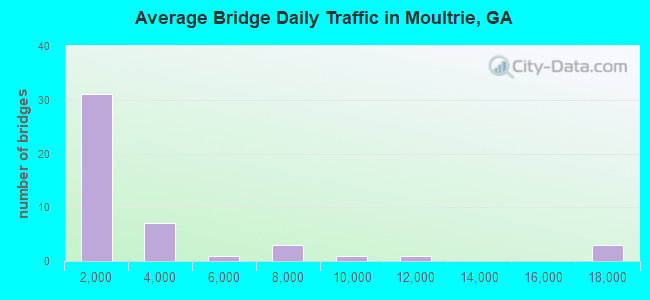
- 139,280Total average daily traffic
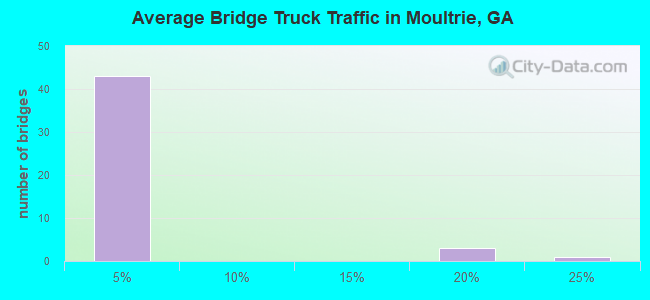
- 3,848Total average daily truck traffic
- 208,920Total future (year 2030) average daily traffic
- National Bridge Inventory (NBI) Registered Bridges for Moultrie
- No street view available for this location
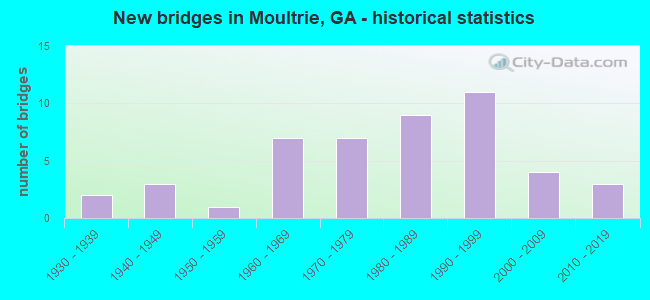
- New bridges - historical statistics
- 21930-1939
- 31940-1949
- 11950-1959
- 71960-1969
- 71970-1979
- 91980-1989
- 111990-1999
- 42000-2009
- 32010-2019
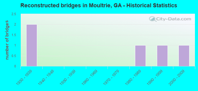
- Reconstructed bridges - Historical Statistics
- 21930-1939
- 01940-1949
- 01950-1959
- 01960-1969
- 01970-1979
- 11980-1989
- 11990-1999
- 12000-2009
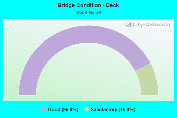
- Bridge Condition - Deck
- 85.0%Good
- 15.0%Satisfactory
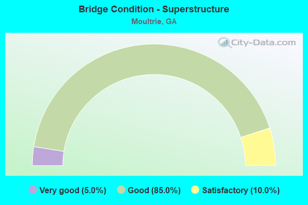
- Bridge Condition - Superstructure
- 5.0%Very good
- 85.0%Good
- 10.0%Satisfactory
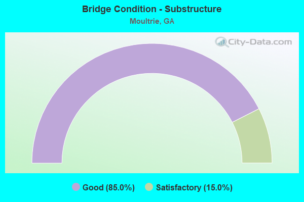
- Bridge Condition - Substructure
- 85.0%Good
- 15.0%Satisfactory
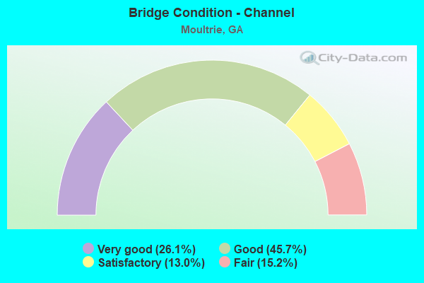
- Bridge Condition - Channel
- 26.1%Very good
- 45.7%Good
- 13.0%Satisfactory
- 15.2%Fair
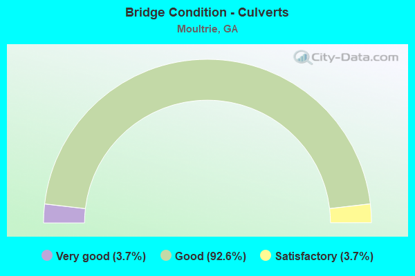
- Bridge Condition - Culverts
- 3.7%Very good
- 92.6%Good
- 3.7%Satisfactory
Find on map >> Show street view
Structure Number: 715229, Location: APP 4.5 SE OF MOULTRIE (Lat: 31.164969, Lng: -83.712175), Route carried "on" structure: County highway 3406, Year Built: 1960, Status: Open, Structure Length: 0.82m (2.69ft), Average Daily Traffic: 1,030 (year 2012), Truck Traffic: 1%, Average Future Daily Traffic: 1,545 (year 2032), Design Load: H 15, Features Intersected: INDIAN CREEK OVERFLOW, Facility Carried by Structure: OLD ADEL ROAD
Minimum Vertical Clearance: 30+ m (98+ ft), Kilometerpoint: 3.219, Lanes on structure: 2, Base Highway Network: Yes, Owner: County Highway Agency, Approaching Roadway Width: 5.8m (19.0ft), Material/Design: Concrete, Design/Construction: Culvert, Number Of Spans In Main Unit: 3, Length of Maximum Span: 2.4m (7.9ft), Curb-To-Curb Width: 7.9m (25.9ft), Out-to-Out Width: 8.7m (28.5ft)
Condition: Channel: Good, Culverts: Good, Operating Rating: 41.7 metric tons, Method Used To Determine Operating Rating: Field evaluation and documented engineering judgment, Inventory Rating: 24.4 metric tons, Method Used To Determine Inventory Rating: Field evaluation and documented engineering judgment, Structural Evaluation: Equal to present minimum criteria, Deck Geometry: Meets minimum limits, Waterway Adequacy: Better than present minimum criteria, Approach Roadway Alignment: Equal to present minimum criteria, Designated Inspection Frequency: Every 24 months, Inspection Date: April 2021
Find on map >> Show street view
Structure Number: 715231, Location: EAST MOULTRIE (Lat: 31.178808, Lng: -83.775619), Route carried "on" structure: State highway 37, Year Built: 2012, Status: Open, Structure Length: 7.32m (24.02ft), Average Daily Traffic: 16,410 (year 2007), Truck Traffic: 1%, Average Future Daily Traffic: 24,615 (year 2030), Design Load: HS 20+Mod, Features Intersected: OKAPILCO CREEK
Minimum Vertical Clearance: 30+ m (98+ ft), Kilometerpoint: 22.531, Lanes on structure: 5, Base Highway Network: Yes, Owner: State Highway Agency, Approaching Roadway Width: 18.6m (61.0ft), Material/Design: Prestressed concrete, Design/Construction: Stringer/Multi-beam, Number Of Spans In Main Unit: 6, Length of Maximum Span: 12.2m (40.0ft), Curb or Sidewalk Widths: Left: 1.8m (5.9ft), Right: 1.8m (5.9ft), Curb-To-Curb Width: 21.9m (71.9ft), Out-to-Out Width: 26.4m (86.6ft)
Condition: Deck: Good, Superstructure: Very good, Substructure: Good, Channel: Very good, Operating Rating: 68.9 metric tons, Method Used To Determine Operating Rating: Allowable Stress (AS), Inventory Rating: 36.2 metric tons, Method Used To Determine Inventory Rating: Allowable Stress (AS), Structural Evaluation: Better than present minimum criteria, Deck Geometry: Somewhat better than minimum adequacy, Waterway Adequacy: Superior to present desirable criteria, Approach Roadway Alignment: Equal to present desirable criteria, Designated Inspection Frequency: Every 24 months, Inspection Date: January 2021, Bridge Improvement Cost: $1,705,000, Roadway Improvement Cost: $170,000, Total Project Cost: $2,557,000, Deck Structure Type: Concrete Cast-file-Place
Find on map >> Show street view
Structure Number: 715235, Location: 5 MI NW OF BERLIN (Lat: 31.110353, Lng: -83.689750), Route carried "on" structure: State highway 133, Year Built: 2017, Status: Open, Structure Length: 0.64m (2.10ft), Average Daily Traffic: 3,830 (year 2011), Truck Traffic: 23%, Average Future Daily Traffic: 5,745 (year 2031), Design Load: HS 20+Mod, Features Intersected: HOG CREEK TRIB
Minimum Vertical Clearance: 30+ m (98+ ft), Kilometerpoint: 12.875, Lanes on structure: 4, Base Highway Network: Yes, Owner: State Highway Agency, Approaching Roadway Width: 8.8m (28.9ft), Skew: 10 degrees, Material/Design: Concrete, Design/Construction: Culvert, Number Of Spans In Main Unit: 2, Length of Maximum Span: 3.0m (9.8ft)
Condition: Channel: Very good, Culverts: Very good, Operating Rating: 53.5 metric tons, Method Used To Determine Operating Rating: Load Factor (LF), Inventory Rating: 31.7 metric tons, Method Used To Determine Inventory Rating: Load Factor (LF), Structural Evaluation: Better than present minimum criteria, Waterway Adequacy: Equal to present desirable criteria, Approach Roadway Alignment: Equal to present desirable criteria, Length Of Structure Improvement: 0.77m (2.53ft), Designated Inspection Frequency: Every 24 months, Inspection Date: January 2021, Bridge Improvement Cost: $1,864,000, Roadway Improvement Cost: $186,000, Total Project Cost: $2,797,000 ( Estimate for 2019)
Find on map >> Show street view
Structure Number: 2755151, Location: APP. 4 NORTHEAST OF COOL (Lat: 31.035947, Lng: -83.808328), Route carried "on" structure: County highway 63, Year Built: 2006, Status: Posted for load, Structure Length: 1.37m (4.49ft), Average Daily Traffic: 10 (year 2011), Truck Traffic: 1%, Average Future Daily Traffic: 15 (year 2031), Design Load: H 10, Features Intersected: BIG CREEK, Facility Carried by Structure: KENNEDY ROAD
Minimum Vertical Clearance: 30+ m (98+ ft), Kilometerpoint: 0.000, Lanes on structure: 2, Base Highway Network: Yes, Owner: County Highway Agency, Approaching Roadway Width: 6.1m (20.0ft), Material/Design: Wood or Timber, Design/Construction: Stringer/Multi-beam, Number Of Spans In Main Unit: 3, Length of Maximum Span: 4.9m (16.1ft), Curb or Sidewalk Widths: Left: 0.2m (0.7ft), Right: 0.2m (0.7ft), Curb-To-Curb Width: 5.7m (18.7ft), Out-to-Out Width: 6.1m (20.0ft)
Condition: Deck: Good, Superstructure: Good, Substructure: Good, Channel: Fair, Operating Rating: 23.5 metric tons, Method Used To Determine Operating Rating: Allowable Stress (AS), Inventory Rating: 16.3 metric tons, Method Used To Determine Inventory Rating: Allowable Stress (AS), Structural Evaluation: Somewhat better than minimum adequacy, Deck Geometry: Meets minimum limits, Waterway Adequacy: Somewhat better than minimum adequacy, Approach Roadway Alignment: Somewhat better than minimum adequacy, Bridge Posting: Required (Relationship of Operating Rating to Maximum Legal Load: 20.0 - 29.9% below), Designated Inspection Frequency: Every 24 months, Inspection Date: September 2020, Bridge Improvement Cost: $176,000, Roadway Improvement Cost: $18,000, Total Project Cost: $264,000, Deck Structure Type: Wood or Timber