Bridge Statistics for Mulhall, Oklahoma (OK)
Condition, Traffic, Stress, Structural Evaluation, Project Costs
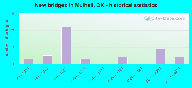
- New bridges - historical statistics
- 31930-1939
- 51940-1949
- 221950-1959
- 31960-1969
- 41980-1989
- 92000-2009
- 42010-2019
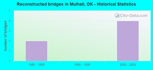
- Reconstructed bridges - Historical Statistics
- 21980-1989
- 01990-1999
- 42000-2009
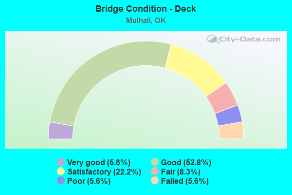
- Bridge Condition - Deck
- 5.6%Very good
- 52.8%Good
- 22.2%Satisfactory
- 8.3%Fair
- 5.6%Poor
- 5.6%Failed
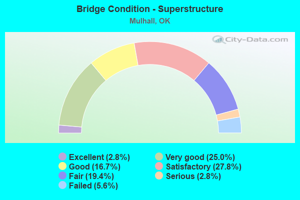
- Bridge Condition - Superstructure
- 2.8%Excellent
- 25.0%Very good
- 16.7%Good
- 27.8%Satisfactory
- 19.4%Fair
- 2.8%Serious
- 5.6%Failed
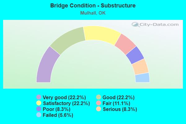
- Bridge Condition - Substructure
- 22.2%Very good
- 22.2%Good
- 22.2%Satisfactory
- 11.1%Fair
- 8.3%Poor
- 8.3%Serious
- 5.6%Failed
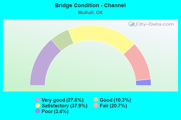
- Bridge Condition - Channel
- 27.6%Very good
- 10.3%Good
- 37.9%Satisfactory
- 20.7%Fair
- 3.4%Poor
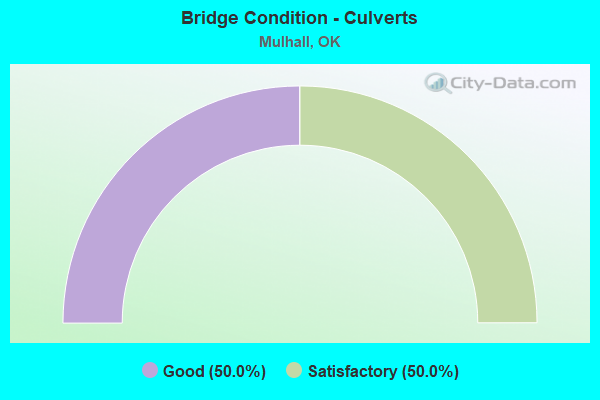
- Bridge Condition - Culverts
- 50.0%Good
- 50.0%Satisfactory
Find on map >> Show street view
Structure Number: 14368, Location: 4.0 MI S JCT SH 51 (Lat: 36.057681, Lng: -97.346167), Route carried "under" structure: County highway 6026, Year Built: 1959, Structure Length: 0. m, Average Daily Traffic: 100 (year 2020), Truck Traffic: 15%, Features Intersected: FAS 6026 (MULHALL RD UND, Facility Carried by Structure: I-35
Minimum Vertical Clearance: 4.39m (14.40ft), Kilometerpoint: 7.884, Lanes on structure: 2, Lanes under structure: 2, Material/Design: Concrete continuous, Design/Construction: Slab, Length of Maximum Span: 12.2m (40.0ft)
Find on map >> Show street view
Structure Number: 14369, Location: 3.0 MI S JCT SH 51 (Lat: 36.072131, Lng: -97.344989), Route carried "under" structure: County highway E0590, Year Built: 1959, Structure Length: 0. m, Average Daily Traffic: 100 (year 2020), Truck Traffic: 15%, Features Intersected: CO. RD. E0650 UNDER, Facility Carried by Structure: I-35
Minimum Vertical Clearance: 4.19m (13.75ft), Kilometerpoint: 9.494, Lanes on structure: 2, Lanes under structure: 2, Material/Design: Concrete continuous, Design/Construction: Slab, Length of Maximum Span: 12.2m (40.0ft)
Find on map >> Show street view
Structure Number: 1437, Location: 3 MI S OF SH 51 JCT (Lat: 36.072133, Lng: -97.345356), Route carried "under" structure: County highway E0590, Year Built: 1959, Structure Length: 0. m, Average Daily Traffic: 100 (year 2020), Truck Traffic: 15%, Features Intersected: CO. RD. E0650 UNDER, Facility Carried by Structure: I-35 SB
Minimum Vertical Clearance: 4.14m (13.58ft), Kilometerpoint: 9.494, Lanes on structure: 2, Lanes under structure: 2, Material/Design: Concrete continuous, Design/Construction: Slab, Length of Maximum Span: 12.2m (40.0ft)
Find on map >> Show street view
Structure Number: 14421, Location: 1.9 MI N LOGAN C/L (Lat: 36.014339, Lng: -97.348219), Route carried "under" structure: Interstate 35, Year Built: 1959, Structure Length: 0. m, Average Daily Traffic: 20,300 (year 2020), Truck Traffic: 36%, Features Intersected: I-35 UNDER, Facility Carried by Structure: CO. RD. E0690
Minimum Vertical Clearance: 4.85m (15.91ft), Kilometerpoint: 3.058, Lanes on structure: 2, Lanes under structure: 4, Material/Design: Concrete continuous, Design/Construction: Slab, Length of Maximum Span: 16.8m (55.1ft)
Find on map >> Show street view
Structure Number: 14424, Location: 6.0 MI S JCT SH 51 (Lat: 36.028928, Lng: -97.345706), Route carried "under" structure: Interstate 35, Year Built: 1959, Structure Length: 0. m, Average Daily Traffic: 20,300 (year 2020), Truck Traffic: 36%, Features Intersected: I-35 UNDER, Facility Carried by Structure: CO. RD. E0680
Minimum Vertical Clearance: 4.89m (16.04ft), Kilometerpoint: 4.698, Lanes on structure: 2, Lanes under structure: 4, Material/Design: Concrete continuous, Design/Construction: Slab, Length of Maximum Span: 16.8m (55.1ft)
Find on map >> Show street view
Structure Number: 14434, Location: 1.0 MI S OF JCT SH 51 (Lat: 36.101175, Lng: -97.345444), Route carried "under" structure: Interstate 35, Year Built: 1959, Structure Length: 0. m, Average Daily Traffic: 20,200 (year 2020), Truck Traffic: 36%, Features Intersected: I-35 UNDER, Facility Carried by Structure: CO. RD. E0630
Minimum Vertical Clearance: 5.00m (16.40ft), Kilometerpoint: 12.711, Lanes on structure: 2, Lanes under structure: 4, Material/Design: Concrete continuous, Design/Construction: Slab, Length of Maximum Span: 16.8m (55.1ft)
Find on map >> Show street view
Structure Number: 14459, Location: 5.0 MI S JCT SH 51 (Lat: 36.043300, Lng: -97.345517), Route carried "under" structure: Interstate 35, Year Built: 1959, Structure Length: 0. m, Average Daily Traffic: 20,300 (year 2020), Truck Traffic: 36%, Features Intersected: I-35 UNDER, Facility Carried by Structure: CO. RD. E0670
Minimum Vertical Clearance: 4.86m (15.94ft), Kilometerpoint: 6.291, Lanes on structure: 2, Lanes under structure: 4, Material/Design: Concrete continuous, Design/Construction: Slab, Length of Maximum Span: 18.3m (60.0ft)
Find on map >> Show street view
Structure Number: 15065, Location: 2.0 MI S JCT SH 51 (Lat: 36.086611, Lng: -97.344981), Route carried "under" structure: County highway E0640, Year Built: 1960, Structure Length: 0. m, Average Daily Traffic: 100 (year 2020), Truck Traffic: 10%, Features Intersected: CO. RD. E0640 UNDER, Facility Carried by Structure: I-35
Minimum Vertical Clearance: 4.19m (13.75ft), Kilometerpoint: 11.101, Lanes on structure: 2, Lanes under structure: 2, Material/Design: Concrete continuous, Design/Construction: Slab, Length of Maximum Span: 12.2m (40.0ft)
Find on map >> Show street view
Structure Number: 15066, Location: 2.0 MI S JCT SH 51 (Lat: 36.086611, Lng: -97.345344), Route carried "under" structure: County highway E0690, Year Built: 1960, Structure Length: 0. m, Average Daily Traffic: 100 (year 2020), Truck Traffic: 10%, Features Intersected: CO. RD. E0640 UNDER, Facility Carried by Structure: I-35 SB
Minimum Vertical Clearance: 4.19m (13.75ft), Kilometerpoint: 11.101, Lanes on structure: 2, Lanes under structure: 2, Material/Design: Concrete continuous, Design/Construction: Slab, Length of Maximum Span: 12.2m (40.0ft)
Find on map >> Show street view
Structure Number: 28182, Location: 8.9N LOGAN C/L (Lat: 36.115372, Lng: -97.344958), Route carried "under" structure: State highway 51, Year Built: 2007, Structure Length: 0. m, Average Daily Traffic: 2,000 (year 2020), Truck Traffic: 10%, Features Intersected: S.H. 51 UNDER, Facility Carried by Structure: I-35 NB
Minimum Vertical Clearance: 5.13m (16.83ft), Kilometerpoint: 0.789, Lanes on structure: 2, Lanes under structure: 5, Material/Design: Prestressed concrete, Design/Construction: Stringer/Multi-beam, Length of Maximum Span: 36.6m (120.1ft)
Find on map >> Show street view
Structure Number: 28183, Location: 8.9N LOGAN C/L (Lat: 36.115372, Lng: -97.345406), Route carried "under" structure: State highway 51, Year Built: 2007, Structure Length: 0. m, Average Daily Traffic: 2,000 (year 2020), Truck Traffic: 10%, Features Intersected: S.H. 51 UNDER, Facility Carried by Structure: I-35 SB
Minimum Vertical Clearance: 5.13m (16.83ft), Kilometerpoint: 0.756, Lanes on structure: 4, Lanes under structure: 5, Material/Design: Prestressed concrete, Design/Construction: Stringer/Multi-beam, Length of Maximum Span: 36.7m (120.4ft)