Bridge Statistics for Mustang Ridge, Texas (TX)
Condition, Traffic, Stress, Structural Evaluation, Project Costs
- National Bridge Inventory (NBI) Statistics
- 64Number of bridges
- 3,028ft / 923mTotal length
- $359,000Total costs
- 521,883Total average daily traffic
- 60,976Total average daily truck traffic
- National Bridge Inventory (NBI) Registered Bridges for Mustang Ridge
- No street view available for this location
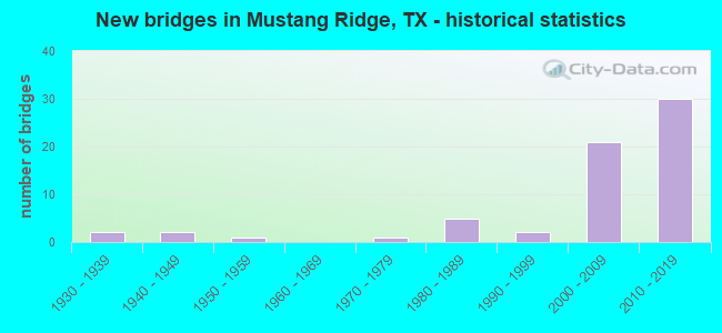
- New bridges - historical statistics
- 21930-1939
- 21940-1949
- 11950-1959
- 11970-1979
- 51980-1989
- 21990-1999
- 212000-2009
- 302010-2019
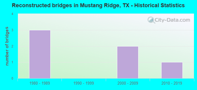
- Reconstructed bridges - Historical Statistics
- 31980-1989
- 01990-1999
- 22000-2009
- 12010-2019
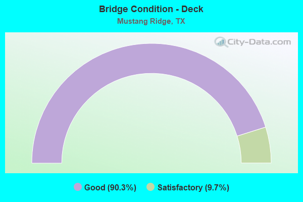
- Bridge Condition - Deck
- 90.3%Good
- 9.7%Satisfactory
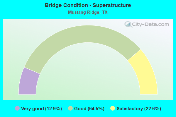
- Bridge Condition - Superstructure
- 12.9%Very good
- 64.5%Good
- 22.6%Satisfactory
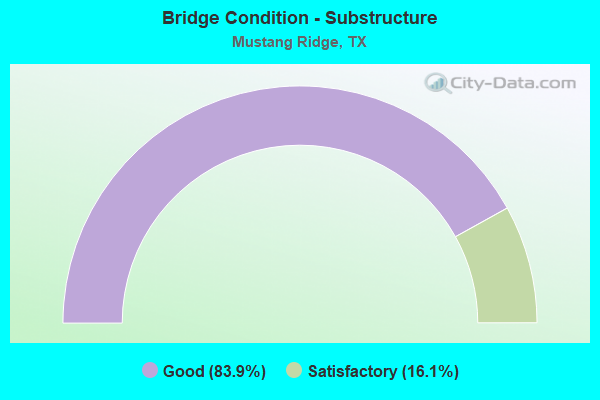
- Bridge Condition - Substructure
- 83.9%Good
- 16.1%Satisfactory
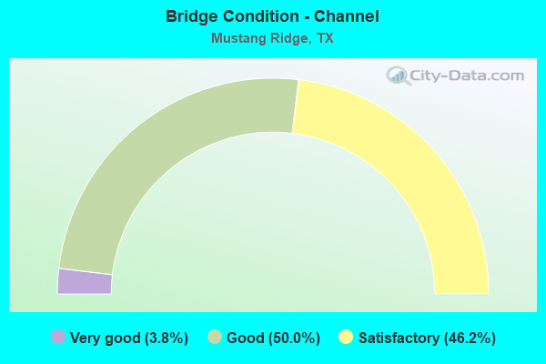
- Bridge Condition - Channel
- 3.8%Very good
- 50.0%Good
- 46.2%Satisfactory
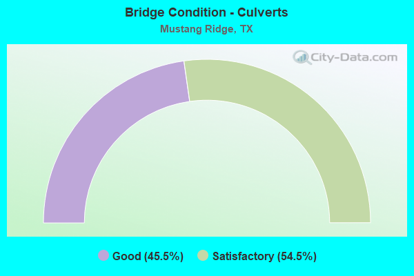
- Bridge Condition - Culverts
- 45.5%Good
- 54.5%Satisfactory
Find on map >> Show street view
Structure Number: 142270AA1800003, Location: 0.50 MI NW OF US 183 (Lat: 30.081942, Lng: -97.700214), Route carried "on" structure: County highway 427, Year Built: 1990, Status: Open, Structure Length: 2.65m (8.69ft), Average Daily Traffic: 331 (year 2020), Average Future Daily Traffic: 300 (year 2027), Features Intersected: MAHA CREEK, Facility Carried by Structure: EVELYN RD
Minimum Vertical Clearance: 30+ m (98+ ft), Kilometerpoint: 1.770, Lanes on structure: 2, Owner: County Highway Agency, Approaching Roadway Width: 6.4m (21.0ft), Material/Design: Concrete, Design/Construction: Culvert, Number Of Spans In Main Unit: 9, Length of Maximum Span: 2.7m (8.9ft), Curb-To-Curb Width: 7.3m (24.0ft), Out-to-Out Width: 9.5m (31.2ft)
Condition: Channel: Satisfactory, Culverts: Good, Operating Rating: 32.7 metric tons, Method Used To Determine Operating Rating: Field evaluation and documented engineering judgment, Inventory Rating: 24.5 metric tons, Method Used To Determine Inventory Rating: Field evaluation and documented engineering judgment, Structural Evaluation: Equal to present minimum criteria, Deck Geometry: Somewhat better than minimum adequacy, Waterway Adequacy: Meets minimum limits, Approach Roadway Alignment: Equal to present desirable criteria, Designated Inspection Frequency: Every 24 months, Inspection Date: Febuary 2020, Deck Structure Type: Concrete Cast-file-Place, Wearing Surface/Protective System: Wearing Surface: Bituminous
Find on map >> Show street view
Structure Number: 140280047104107, Location: 1.1 MI S OF TRAVIS C/L (Lat: 30.027475, Lng: -97.686953), Route carried "under" structure: State highway 21, Year Built: 2010, Structure Length: 0. m, Average Daily Traffic: 11,250 (year 2013), Truck Traffic: 9%, Features Intersected: SH 21, Facility Carried by Structure: SH130 NBFR/US183NB
Minimum Vertical Clearance: 5.21m (17.09ft), Kilometerpoint: 2.121, Lanes on structure: 2, Lanes under structure: 8, Material/Design: Prestressed concrete, Design/Construction: Stringer/Multi-beam, Length of Maximum Span: 30.5m (100.1ft)
Find on map >> Show street view
Structure Number: 140280047104108, Location: 1.1 MI S OF TRAVIS C/L (Lat: 30.027294, Lng: -97.687503), Route carried "under" structure: State highway 21, Year Built: 2011, Structure Length: 0. m, Average Daily Traffic: 17,179 (year 2010), Truck Traffic: 9%, Features Intersected: SH 21, Facility Carried by Structure: SH 130 NB ML
Minimum Vertical Clearance: 5.54m (18.18ft), Kilometerpoint: 94.155, Lanes on structure: 2, Lanes under structure: 8, Material/Design: Prestressed concrete, Design/Construction: Stringer/Multi-beam, Length of Maximum Span: 30.5m (100.1ft)
Find on map >> Show street view
Structure Number: 140280047104109, Location: 0.9 MI S OF TRAVIS C/L (Lat: 30.028231, Lng: -97.688264), Route carried "under" structure: State highway 21, Year Built: 2011, Structure Length: 0. m, Average Daily Traffic: 11,250 (year 2013), Truck Traffic: 9%, Features Intersected: SH 21, Facility Carried by Structure: SH 130 SB ML
Minimum Vertical Clearance: 5.18m (16.99ft), Kilometerpoint: 2.013, Lanes on structure: 2, Lanes under structure: 8, Material/Design: Prestressed concrete, Design/Construction: Stringer/Multi-beam, Length of Maximum Span: 30.5m (100.1ft)
Find on map >> Show street view
Structure Number: 14028004710411, Location: 0.9 MI S OF TRAVIS C/L (Lat: 30.028125, Lng: -97.688811), Route carried "under" structure: State highway 21, Year Built: 2011, Structure Length: 0. m, Average Daily Traffic: 11,250 (year 2013), Truck Traffic: 9%, Features Intersected: SH 21, Facility Carried by Structure: SH130SBFR/US183SB
Minimum Vertical Clearance: 5.36m (17.59ft), Kilometerpoint: 1.951, Lanes on structure: 2, Lanes under structure: 8, Material/Design: Prestressed concrete, Design/Construction: Stringer/Multi-beam, Length of Maximum Span: 30.5m (100.1ft)
Find on map >> Show street view
Structure Number: 140280358301041, Location: 1.6 MI S OF SH 21 (Lat: 30.005919, Lng: -97.687514), Route carried "under" structure: County highway 179, Year Built: 2011, Structure Length: 0. m, Average Daily Traffic: 547 (year 2010), Features Intersected: Co Rd 179, Facility Carried by Structure: SH 130 SB ML
Minimum Vertical Clearance: 5.49m (18.01ft), Kilometerpoint: 1.529, Lanes on structure: 2, Lanes under structure: 2, Toll: On toll road, Material/Design: Prestressed concrete, Design/Construction: Stringer/Multi-beam, Length of Maximum Span: 50.3m (165.0ft)
Find on map >> Show street view
Structure Number: 142270015201041, Location: AT JCT US 183 & SH 45SE (Lat: 30.080908, Lng: -97.693778), Route carried "under" structure: US 183, Year Built: 2009, Structure Length: 0. m, Average Daily Traffic: 16,500 (year 2016), Truck Traffic: 7%, Features Intersected: SH 45 TOLL, Facility Carried by Structure: SH 45SE EB
Minimum Vertical Clearance: 6.10m (20.01ft), Kilometerpoint: 58.780, Lanes on structure: 2, Lanes under structure: 6, Material/Design: Prestressed concrete, Design/Construction: Stringer/Multi-beam, Length of Maximum Span: 36.6m (120.1ft)
Find on map >> Show street view
Structure Number: 142270015201042, Location: AT JCT US 183 & SH 45SE (Lat: 30.082231, Lng: -97.691592), Route carried "under" structure: US 183, Year Built: 2009, Structure Length: 0. m, Average Daily Traffic: 16,500 (year 2016), Truck Traffic: 7%, Features Intersected: SH 45 TOLL, Facility Carried by Structure: SH 45SE WB
Minimum Vertical Clearance: 5.61m (18.41ft), Kilometerpoint: 58.780, Lanes on structure: 2, Lanes under structure: 6, Material/Design: Prestressed concrete, Design/Construction: Stringer/Multi-beam, Length of Maximum Span: 36.6m (120.1ft)
Find on map >> Show street view
Structure Number: 142270044006153, Location: 1.95 MI N OF US 183 (Lat: 30.102103, Lng: -97.669125), Route carried "under" structure: County highway , Year Built: 2008, Structure Length: 0. m, Average Daily Traffic: 500 (year 2010), Features Intersected: Von Quintus Road, Facility Carried by Structure: SH 130 NB
Minimum Vertical Clearance: 5.54m (18.18ft), Kilometerpoint: 0.752, Lanes on structure: 2, Lanes under structure: 2, Material/Design: Prestressed concrete, Design/Construction: Stringer/Multi-beam, Length of Maximum Span: 36.6m (120.1ft)
Find on map >> Show street view
Structure Number: 142270044006154, Location: 1.95 MI N OF US 183 (Lat: 30.103153, Lng: -97.669122), Route carried "under" structure: County highway , Year Built: 2008, Structure Length: 0. m, Average Daily Traffic: 500 (year 2010), Features Intersected: Von Quintus Rd, Facility Carried by Structure: SH 130 SB
Minimum Vertical Clearance: 5.59m (18.34ft), Kilometerpoint: 0.703, Lanes on structure: 2, Lanes under structure: 2, Material/Design: Prestressed concrete, Design/Construction: Stringer/Multi-beam, Length of Maximum Span: 36.6m (120.1ft)
Find on map >> Show street view
Structure Number: 142270044006155, Location: 1.05 MI N OF US 183 (Lat: 30.091969, Lng: -97.678917), Route carried "under" structure: County highway , Year Built: 2008, Structure Length: 0. m, Average Daily Traffic: 250 (year 2010), Features Intersected: Maha Loop Rd, Facility Carried by Structure: SH 130 NB
Minimum Vertical Clearance: 6.17m (20.24ft), Kilometerpoint: 0.768, Lanes on structure: 2, Lanes under structure: 2, Material/Design: Prestressed concrete, Design/Construction: Stringer/Multi-beam, Length of Maximum Span: 35.1m (115.2ft)
Find on map >> Show street view
Structure Number: 142270044006156, Location: 1.05 MI N OF US 183 (Lat: 30.092958, Lng: -97.678975), Route carried "under" structure: County highway , Year Built: 2008, Structure Length: 0. m, Average Daily Traffic: 500 (year 2010), Features Intersected: Maha Loop, Facility Carried by Structure: SH 45 WB
Minimum Vertical Clearance: 5.44m (17.85ft), Kilometerpoint: 0.719, Lanes on structure: 2, Lanes under structure: 2, Material/Design: Prestressed concrete, Design/Construction: Stringer/Multi-beam, Length of Maximum Span: 35.1m (115.2ft)
Find on map >> Show street view
Structure Number: 142270044006254, Location: 2.0 MI N OF SH 21 (Lat: 30.055808, Lng: -97.690594), Route carried "under" structure: County highway , Year Built: 2011, Structure Length: 0. m, Average Daily Traffic: 2,716 (year 2010), Features Intersected: Laws Road, Facility Carried by Structure: SH 130 NB ML
Minimum Vertical Clearance: 5.21m (17.09ft), Kilometerpoint: 0.000, Lanes on structure: 3, Lanes under structure: 2, Material/Design: Prestressed concrete, Design/Construction: Stringer/Multi-beam, Length of Maximum Span: 34.1m (111.9ft)
Find on map >> Show street view
Structure Number: 142270044006255, Location: 2.0 MI N OF SH 21 (Lat: 30.056481, Lng: -97.691506), Route carried "under" structure: County highway , Year Built: 2011, Structure Length: 0. m, Average Daily Traffic: 2,716 (year 2010), Features Intersected: Laws Road, Facility Carried by Structure: SH 130 SB ML
Minimum Vertical Clearance: 5.39m (17.68ft), Kilometerpoint: 91.015, Lanes on structure: 3, Lanes under structure: 2, Material/Design: Prestressed concrete, Design/Construction: Stringer/Multi-beam, Length of Maximum Span: 34.1m (111.9ft)
Find on map >> Show street view
Structure Number: 142270044006256, Location: 1.10 MI N OF SH 21 (Lat: 30.043689, Lng: -97.689325), Route carried "under" structure: County highway 176, Year Built: 2011, Structure Length: 0. m, Average Daily Traffic: 2,179 (year 2010), Features Intersected: Co Rd 176, Facility Carried by Structure: SH 130 NB ML
Minimum Vertical Clearance: 6.48m (21.26ft), Kilometerpoint: 0.000, Lanes on structure: 3, Lanes under structure: 2, Material/Design: Prestressed concrete, Design/Construction: Stringer/Multi-beam, Length of Maximum Span: 34.1m (111.9ft)
Find on map >> Show street view
Structure Number: 142270044006257, Location: 1.1 MI N OF SH 21 (Lat: 30.044339, Lng: -97.690056), Route carried "under" structure: County highway 176, Year Built: 2011, Structure Length: 0. m, Average Daily Traffic: 2,179 (year 2010), Features Intersected: CR 176, Facility Carried by Structure: SH 130 SB ML
Minimum Vertical Clearance: 5.39m (17.68ft), Kilometerpoint: 0.000, Lanes on structure: 2, Lanes under structure: 2, Material/Design: Prestressed concrete, Design/Construction: Stringer/Multi-beam, Length of Maximum Span: 34.1m (111.9ft)
Find on map >> Show street view
Structure Number: 142270044006262, Location: 3.75 MI N OF SH 21 (Lat: 30.080306, Lng: -97.701528), Route carried "under" structure: ServiceState highway 130, Year Built: 2011, Structure Length: 0. m, Average Daily Traffic: 17,800 (year 2016), Truck Traffic: 15%, Features Intersected: SH 45 EB CONN SH 130 SB
Minimum Vertical Clearance: 23.01m (75.49ft), Kilometerpoint: 88.559, Lanes on structure: 1, Lanes under structure: 4, Material/Design: Prestressed concrete, Design/Construction: Stringer/Multi-beam, Length of Maximum Span: 41.5m (136.2ft)
Find on map >> Show street view
Structure Number: 142270044006263, Location: 1.00 MI N OF US 183 (Lat: 30.092872, Lng: -97.678806), Route carried "under" structure: County highway , Year Built: 2011, Structure Length: 0. m, Average Daily Traffic: 250 (year 2016), Features Intersected: SH 130 SB, Facility Carried by Structure: SH 130 SB ML
Minimum Vertical Clearance: 6.20m (20.34ft), Kilometerpoint: 0.739, Lanes on structure: 2, Lanes under structure: 2, Material/Design: Prestressed concrete, Design/Construction: Stringer/Multi-beam, Length of Maximum Span: 35.1m (115.2ft)
Find on map >> Show street view
Structure Number: 142270120005057, Location: 0.50 MI W OF US 183 (Lat: 30.081044, Lng: -97.695856), Route carried "under" structure: County highway , Year Built: 2009, Structure Length: 0. m, Average Daily Traffic: 100 (year 2016), Truck Traffic: 1%, Features Intersected: SH 45 SE WB, Facility Carried by Structure: SH 45 SE WBML
Minimum Vertical Clearance: 5.64m (18.50ft), Kilometerpoint: 0.002, Lanes on structure: 2, Lanes under structure: 2, Material/Design: Prestressed concrete, Design/Construction: Stringer/Multi-beam, Length of Maximum Span: 35.4m (116.1ft)
Find on map >> Show street view
Structure Number: 142270120005058, Location: 0.50 MI W OF US 183 (Lat: 30.080489, Lng: -97.701233), Route carried "under" structure: County highway , Year Built: 2009, Structure Length: 0. m, Average Daily Traffic: 100 (year 2016), Truck Traffic: 1%, Features Intersected: SH 45 SE EB, Facility Carried by Structure: SH 45 SE EBML
Minimum Vertical Clearance: 6.48m (21.26ft), Kilometerpoint: 0.002, Lanes on structure: 2, Lanes under structure: 2, Material/Design: Prestressed concrete, Design/Construction: Stringer/Multi-beam, Length of Maximum Span: 35.4m (116.1ft)
Find on map >> Show street view
Structure Number: 142270120005122, Location: 3.2 MI N OF SH 21 (Lat: 30.073978, Lng: -97.691783), Route carried "under" structure: ServiceState highway 45, Year Built: 2011, Structure Length: 0. m, Average Daily Traffic: 1,700 (year 2010), Truck Traffic: 13%, Features Intersected: SH 130 NB FRTG RD, Facility Carried by Structure: SH 130 NB ML
Minimum Vertical Clearance: 5.44m (17.85ft), Kilometerpoint: 20.754, Lanes on structure: 2, Lanes under structure: 4, Material/Design: Prestressed concrete, Design/Construction: Stringer/Multi-beam, Length of Maximum Span: 40.8m (133.9ft)
Find on map >> Show street view
Structure Number: 142270120005123, Location: 3.75 MI N OF SH 21 (Lat: 30.084728, Lng: -97.687856), Route carried "under" structure: Other road 45, Year Built: 2011, Structure Length: 0. m, Average Daily Traffic: 5,000 (year 2016), Truck Traffic: 13%, Features Intersected: SH 130 SB TOLL, Facility Carried by Structure: SH 130 SB ML
Minimum Vertical Clearance: 6.40m (21.00ft), Kilometerpoint: 20.696, Lanes on structure: 2, Lanes under structure: 7, Toll: On toll road, Material/Design: Prestressed concrete, Design/Construction: Stringer/Multi-beam, Length of Maximum Span: 44.8m (147.0ft)
Find on map >> Show street view
Structure Number: 142270120005124, Location: 3.75 MI N OF SH 21 (Lat: 30.080103, Lng: -97.693317), Route carried "under" structure: Other road 45, Year Built: 2011, Structure Length: 0. m, Average Daily Traffic: 10,000 (year 2010), Truck Traffic: 13%, Features Intersected: US 183/SH 130/SH 45 SE
Minimum Vertical Clearance: 14.23m (46.69ft), Kilometerpoint: 22.518, Lanes under structure: 15, Toll: On toll road, Material/Design: Steel, Design/Construction: Stringer/Multi-beam, Length of Maximum Span: 57.0m (187.0ft)