Bridge Statistics for Olympia, Washington (WA)
Condition, Traffic, Stress, Structural Evaluation, Project Costs
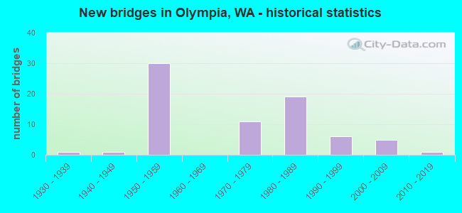
- New bridges - historical statistics
- 11930-1939
- 11940-1949
- 301950-1959
- 111970-1979
- 191980-1989
- 61990-1999
- 52000-2009
- 12010-2019
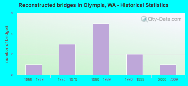
- Reconstructed bridges - Historical Statistics
- 11960-1969
- 31970-1979
- 51980-1989
- 21990-1999
- 12000-2009
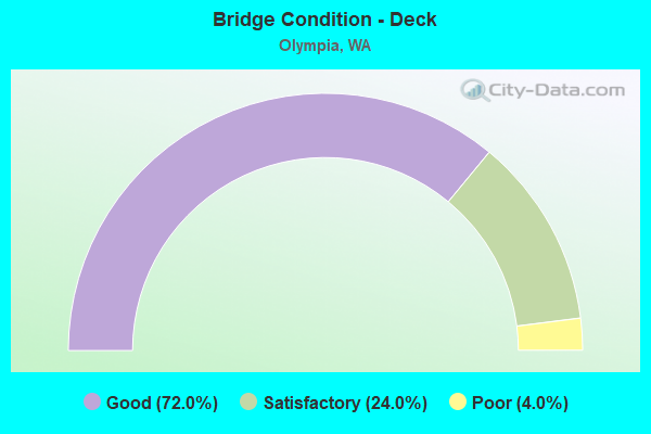
- Bridge Condition - Deck
- 72.0%Good
- 24.0%Satisfactory
- 4.0%Poor
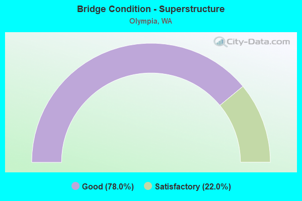
- Bridge Condition - Superstructure
- 78.0%Good
- 22.0%Satisfactory
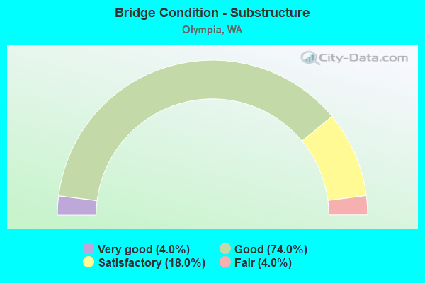
- Bridge Condition - Substructure
- 4.0%Very good
- 74.0%Good
- 18.0%Satisfactory
- 4.0%Fair
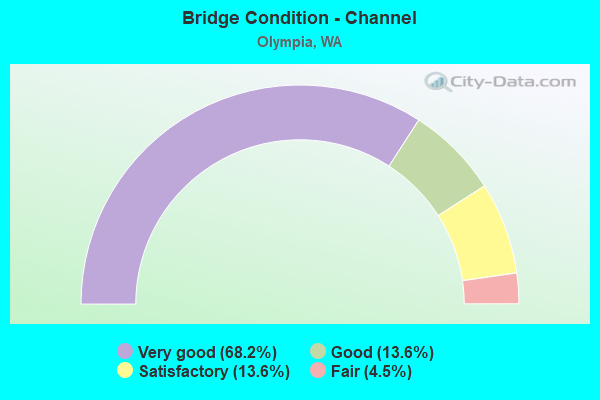
- Bridge Condition - Channel
- 68.2%Very good
- 13.6%Good
- 13.6%Satisfactory
- 4.5%Fair
Find on map >> Show street view
Structure Number: 82518, Location: 0.6 m E Libby Rd (Lat: 47.126544, Lng: -122.852975), Route carried "on" structure: County highway 15665, Year Built: 1958, Year Reconstructed: 1977, Status: Open, Structure Length: 1.83m (6.00ft), Average Daily Traffic: 1,137 (year 2020), Truck Traffic: 15%, Average Future Daily Traffic: 1,758 (year 2042), Design Load: HS 20, Features Intersected: WOODARD BAY, Facility Carried by Structure: WOODARD BAY ROAD
Minimum Vertical Clearance: 30+ m (98+ ft), Kilometerpoint: 0.001, Lanes on structure: 2, Owner: County Highway Agency, Approaching Roadway Width: 7.3m (24.0ft), Material/Design: Concrete continuous, Design/Construction: Slab, Number Of Spans In Main Unit: 3, Length of Maximum Span: 6.7m (22.0ft), Curb-To-Curb Width: 7.3m (24.0ft), Out-to-Out Width: 8.0m (26.2ft)
Condition: Deck: Satisfactory, Superstructure: Satisfactory, Substructure: Fair, Channel: Good, Operating Rating: 53.5 metric tons, Method Used To Determine Operating Rating: Load Factor (LF), Inventory Rating: 32.7 metric tons, Method Used To Determine Inventory Rating: Load Factor (LF), Structural Evaluation: Somewhat better than minimum adequacy, Deck Geometry: Meets minimum limits, Waterway Adequacy: Better than present minimum criteria, Approach Roadway Alignment: Equal to present desirable criteria, Length Of Structure Improvement: 2.13m (6.99ft), Designated Inspection Frequency: Every 24 months, Inspection Date: May 2020, Bridge Improvement Cost: $1,064,000, Roadway Improvement Cost: $213,000, Total Project Cost: $2,128,000 ( Estimate for 2014), Deck Structure Type: Concrete Cast-file-Place, Wearing Surface/Protective System: Wearing Surface: Integral Concrete
Find on map >> Show street view
Structure Number: 82529, Location: 0.3 m W Shinkle Rd (Lat: 47.122522, Lng: -122.849850), Route carried "on" structure: County highway 15665, Year Built: 1958, Status: Open, Structure Length: 2.32m (7.61ft), Average Daily Traffic: 1,137 (year 2020), Truck Traffic: 10%, Average Future Daily Traffic: 1,758 (year 2042), Design Load: HS 20, Features Intersected: WALKING TRAIL, Facility Carried by Structure: WOODARD BAY
Minimum Vertical Clearance: 30+ m (98+ ft), Kilometerpoint: 0.001, Lanes on structure: 2, Owner: County Highway Agency, Approaching Roadway Width: 8.5m (27.9ft), Material/Design: Concrete continuous, Design/Construction: Slab, Number Of Spans In Main Unit: 3, Length of Maximum Span: 8.5m (27.9ft), Curb-To-Curb Width: 7.4m (24.3ft), Out-to-Out Width: 8.0m (26.2ft)
Condition: Deck: Good, Superstructure: Good, Substructure: Good, Operating Rating: 52.6 metric tons, Method Used To Determine Operating Rating: Load Factor (LF), Inventory Rating: 31.7 metric tons, Method Used To Determine Inventory Rating: Load Factor (LF), Structural Evaluation: Better than present minimum criteria, Deck Geometry: Meets minimum limits, Approach Roadway Alignment: Equal to present minimum criteria, Length Of Structure Improvement: 2.32m (7.61ft), Designated Inspection Frequency: Every 24 months, Inspection Date: May 2020, Bridge Improvement Cost: $456,000, Roadway Improvement Cost: $91,000, Total Project Cost: $912,000 ( Estimate for 2014), Deck Structure Type: Concrete Cast-file-Place, Wearing Surface/Protective System: Wearing Surface: Monolithic Concrete
Find on map >> Show street view
Structure Number: 83235, Location: .05 S I5 (Lat: 47.039131, Lng: -122.869064), Route carried "on" structure: City street 10490, Year Built: 1973, Status: Open, Structure Length: 6.10m (20.01ft), Average Daily Traffic: 9,640 (year 2017), Truck Traffic: 5%, Average Future Daily Traffic: 15,540 (year 2035), Design Load: HS 20, Features Intersected: TRAIL & CREEK, Facility Carried by Structure: BOULEVARD ROAD
Minimum Vertical Clearance: 30+ m (98+ ft), Kilometerpoint: 0.001, Lanes on structure: 2, Owner: City or Municipal Highway Agency, Approaching Roadway Width: 13.4m (44.0ft), Skew: 4 degrees, Material/Design: Prestressed concrete continuous, Design/Construction: Stringer/Multi-beam, Number Of Spans In Main Unit: 3, Length of Maximum Span: 20.4m (66.9ft), Curb or Sidewalk Widths: Left: 1.5m (4.9ft), Right: 1.5m (4.9ft), Curb-To-Curb Width: 13.4m (44.0ft), Out-to-Out Width: 17.0m (55.8ft)
Condition: Deck: Good, Superstructure: Good, Substructure: Good, Channel: Very good, Operating Rating: 39.5 metric tons, Method Used To Determine Operating Rating: Load and Resistance Factor Rating (LRFR) rating reported by rating factor(RF) method using HL-93 loadings, Inventory Rating: 30.5 metric tons, Method Used To Determine Inventory Rating: Load and Resistance Factor Rating (LRFR) rating reported by rating factor(RF) method using HL-93 loadings, Structural Evaluation: Better than present minimum criteria, Deck Geometry: Equal to present minimum criteria, Waterway Adequacy: Equal to present desirable criteria, Approach Roadway Alignment: Equal to present desirable criteria, Length Of Structure Improvement: 6.10m (20.01ft), Designated Inspection Frequency: Every 24 months, Inspection Date: September 2018, Bridge Improvement Cost: $1,840,000, Roadway Improvement Cost: $368,000, Total Project Cost: $3,680,000 ( Estimate for 2014), Deck Structure Type: Concrete Cast-file-Place, Wearing Surface/Protective System: Wearing Surface: Monolithic Concrete
Find on map >> Show street view
Structure Number: 84432, Location: 150 ft S Johnson Point Rd (Lat: 47.090203, Lng: -122.822467), Route carried "on" structure: County highway 12085, Year Built: 1955, Status: Open, Structure Length: 1.86m (6.10ft), Average Daily Traffic: 5,737 (year 2021), Truck Traffic: 15%, Average Future Daily Traffic: 8,869 (year 2041), Design Load: HS 20, Features Intersected: WOODLAND CREEK, Facility Carried by Structure: HAWKS PRAIRIE ROAD
Minimum Vertical Clearance: 30+ m (98+ ft), Kilometerpoint: 0.001, Lanes on structure: 2, Owner: County Highway Agency, Approaching Roadway Width: 7.6m (24.9ft), Material/Design: Steel continuous, Design/Construction: Stringer/Multi-beam, Number Of Spans In Main Unit: 2, Length of Maximum Span: 9.1m (29.9ft), Curb-To-Curb Width: 7.3m (24.0ft), Out-to-Out Width: 7.8m (25.6ft)
Condition: Deck: Satisfactory, Superstructure: Satisfactory, Substructure: Fair, Channel: Good, Operating Rating: 89.8 metric tons, Method Used To Determine Operating Rating: Load Factor (LF), Inventory Rating: 72.6 metric tons, Method Used To Determine Inventory Rating: Load Factor (LF), Structural Evaluation: Somewhat better than minimum adequacy, Deck Geometry: High priority of replacement, Waterway Adequacy: Equal to present minimum criteria, Approach Roadway Alignment: High priority of corrective action, Length Of Structure Improvement: 2.16m (7.09ft), Designated Inspection Frequency: Every 24 months, Inspection Date: May 2021, Bridge Improvement Cost: $1,079,000, Roadway Improvement Cost: $216,000, Total Project Cost: $2,158,000 ( Estimate for 2014), Deck Structure Type: Concrete Cast-file-Place, Wearing Surface/Protective System: Wearing Surface: Monolithic Concrete
Find on map >> Show street view
Structure Number: 85006, Location: PRIEST POINT PK (Lat: 47.069972, Lng: -122.895278), Route carried "on" structure: ServiceCity street 92003, Year Built: 1972, Status: Posted for load, Structure Length: 4.36m (14.30ft), Average Daily Traffic: 600 (year 2014), Truck Traffic: 1%, Average Future Daily Traffic: 250 (year 2036), Design Load: H 10, Features Intersected: EAST BAY DRIVE NE, Facility Carried by Structure: PARK ACCESS RD
Minimum Vertical Clearance: 30+ m (98+ ft), Kilometerpoint: 0.001, Lanes on structure: 2, Lanes under structure: 2, Owner: City or Municipal Highway Agency, Approaching Roadway Width: 6.1m (20.0ft), Skew: 1 degrees, Material/Design: Prestressed concrete continuous, Design/Construction: Frame, Number Of Spans In Main Unit: 3, Length of Maximum Span: 19.8m (65.0ft), Curb or Sidewalk Widths: Left: 1.6m (5.2ft), Right: 1.6m (5.2ft), Curb-To-Curb Width: 6.1m (20.0ft), Out-to-Out Width: 9.8m (32.2ft)
Condition: Deck: Good, Superstructure: Good, Substructure: Good, Operating Rating: 13.6 metric tons, Method Used To Determine Operating Rating: Load and Resistance Factor Rating (LRFR) rating reported by rating factor(RF) method using HL-93 loadings, Inventory Rating: 10.4 metric tons, Method Used To Determine Inventory Rating: Load and Resistance Factor Rating (LRFR) rating reported by rating factor(RF) method using HL-93 loadings, Structural Evaluation: High priority of corrective action, Deck Geometry: High priority of corrective action, Underclear: Better than present minimum criteria, Approach Roadway Alignment: Equal to present minimum criteria, Bridge Posting: Required (Relationship of Operating Rating to Maximum Legal Load: 0.1 - 9.9% below), Designated Inspection Frequency: Every 24 months, Inspection Date: November 2020, Deck Structure Type: Concrete Cast-file-Place, Wearing Surface/Protective System: Wearing Surface: Monolithic Concrete
Find on map >> Show street view
Structure Number: 85039, Location: 0.1 N EVERGREEN DR (Lat: 47.028822, Lng: -122.926294), Route carried "on" structure: City street 92004, Year Built: 1986, Status: Open, Structure Length: 14.78m (48.49ft), Average Daily Traffic: 24,550 (year 2017), Truck Traffic: 5%, Average Future Daily Traffic: 36,650 (year 2036), Design Load: HS 20+Mod, Features Intersected: PERCIVAL CREEK AND BNRR, Facility Carried by Structure: COOPER POINT ROAD
Minimum Vertical Clearance: 30+ m (98+ ft), Kilometerpoint: 0.001, Lanes on structure: 5, Owner: City or Municipal Highway Agency, Approaching Roadway Width: 18.3m (60.0ft), Skew: 3 degrees, Material/Design: Prestressed concrete continuous, Design/Construction: Stringer/Multi-beam, Number Of Spans In Main Unit: 4, Length of Maximum Span: 40.5m (132.9ft), Curb or Sidewalk Widths: Left: 1.5m (4.9ft), Right: 1.5m (4.9ft), Curb-To-Curb Width: 18.3m (60.0ft), Out-to-Out Width: 22.6m (74.1ft)
Condition: Deck: Satisfactory, Superstructure: Good, Substructure: Good, Channel: Fair, Operating Rating: 45.0 metric tons, Method Used To Determine Operating Rating: Load and Resistance Factor Rating (LRFR) rating reported by rating factor(RF) method using HL-93 loadings, Inventory Rating: 34.7 metric tons, Method Used To Determine Inventory Rating: Load and Resistance Factor Rating (LRFR) rating reported by rating factor(RF) method using HL-93 loadings, Structural Evaluation: Better than present minimum criteria, Deck Geometry: High priority of replacement, Underclear: Superior to present desirable criteria, Waterway Adequacy: Equal to present desirable criteria, Approach Roadway Alignment: Equal to present desirable criteria, Designated Inspection Frequency: Every 24 months, Inspection Date: September 2018, Deck Structure Type: Concrete Cast-file-Place, Wearing Surface/Protective System: Wearing Surface: Monolithic Concrete, Deck Protection: Epoxy Coated Reinforcing
Find on map >> Show street view
Structure Number: 85227, Location: 5TH AVENUE (Lat: 47.043644, Lng: -122.911278), Route carried "on" structure: City street 92002, Year Built: 1958, Year Reconstructed: 2004, Status: Posted for load, Structure Length: 4.33m (14.21ft), Average Daily Traffic: 16,790 (year 2020), Truck Traffic: 5%, Average Future Daily Traffic: 28,000 (year 2036), Design Load: HS 20, Features Intersected: BNRR, Facility Carried by Structure: W 5TH AVENUE
Minimum Vertical Clearance: 30+ m (98+ ft), Kilometerpoint: 0.001, Lanes on structure: 2, Owner: City or Municipal Highway Agency, Approaching Roadway Width: 8.8m (28.9ft), Skew: 9 degrees, Material/Design: Concrete continuous, Design/Construction: Slab, Number Of Spans In Main Unit: 3, Length of Maximum Span: 17.1m (56.1ft), Curb or Sidewalk Widths: Left: 1.5m (4.9ft), Right: 2.4m (7.9ft), Curb-To-Curb Width: 8.8m (28.9ft), Out-to-Out Width: 13.4m (44.0ft)
Condition: Deck: Satisfactory, Superstructure: Good, Substructure: Good, Operating Rating: 13.9 metric tons, Method Used To Determine Operating Rating: Load and Resistance Factor Rating (LRFR) rating reported by rating factor(RF) method using HL-93 loadings, Inventory Rating: 10.7 metric tons, Method Used To Determine Inventory Rating: Load and Resistance Factor Rating (LRFR) rating reported by rating factor(RF) method using HL-93 loadings, Structural Evaluation: High priority of corrective action, Deck Geometry: High priority of replacement, Approach Roadway Alignment: Equal to present minimum criteria, Bridge Posting: Required (Relationship of Operating Rating to Maximum Legal Load: 30.0 - 39.9% below), Length Of Structure Improvement: 4.33m (14.21ft), Designated Inspection Frequency: Every 24 months, Inspection Date: December 2020, Bridge Improvement Cost: $880,000, Roadway Improvement Cost: $176,000, Total Project Cost: $1,761,000 ( Estimate for 2014), Deck Structure Type: Concrete Cast-file-Place, Wearing Surface/Protective System: Wearing Surface: Monolithic Concrete
Find on map >> Show street view
Structure Number: 85973, Location: 50 yd S of Mckenz Rd intr (Lat: 47.030967, Lng: -122.991881), Route carried "on" structure: County highway 11155, Year Built: 1992, Status: Open, Structure Length: 1.89m (6.20ft), Average Daily Traffic: 2,686 (year 2020), Truck Traffic: 15%, Average Future Daily Traffic: 4,153 (year 2042), Design Load: HS 20, Features Intersected: MCLANE CREEK, Facility Carried by Structure: MCLANE DELPHI ROAD
Minimum Vertical Clearance: 30+ m (98+ ft), Kilometerpoint: 0.001, Lanes on structure: 2, Owner: County Highway Agency, Approaching Roadway Width: 10.4m (34.1ft), Skew: 1 degrees, Material/Design: Prestressed concrete, Design/Construction: Stringer/Multi-beam, Number Of Spans In Main Unit: 1, Length of Maximum Span: 18.3m (60.0ft), Curb-To-Curb Width: 10.4m (34.1ft), Out-to-Out Width: 10.9m (35.8ft)
Condition: Deck: Good, Superstructure: Good, Substructure: Good, Channel: Good, Operating Rating: 76.2 metric tons, Method Used To Determine Operating Rating: Load Factor (LF), Inventory Rating: 45.4 metric tons, Method Used To Determine Inventory Rating: Load Factor (LF), Structural Evaluation: Better than present minimum criteria, Deck Geometry: Somewhat better than minimum adequacy, Waterway Adequacy: Equal to present desirable criteria, Approach Roadway Alignment: Equal to present minimum criteria, Length Of Structure Improvement: 2.19m (7.19ft), Designated Inspection Frequency: Every 24 months, Inspection Date: September 2020, Bridge Improvement Cost: $1,094,000, Roadway Improvement Cost: $219,000, Total Project Cost: $2,189,000 ( Estimate for 2014), Deck Structure Type: Concrete Cast-file-Place, Wearing Surface/Protective System: Wearing Surface: Monolithic Concrete, Deck Protection: Epoxy Coated Reinforcing
Find on map >> Show street view
Structure Number: 85974, Location: 0.9 m S of SR101 overpass (Lat: 47.031683, Lng: -122.990806), Route carried "on" structure: County highway 11155, Year Built: 1993, Status: Open, Structure Length: 3.35m (10.99ft), Average Daily Traffic: 2,686 (year 2020), Truck Traffic: 15%, Average Future Daily Traffic: 4,153 (year 2042), Design Load: HS 20, Features Intersected: MCLANE CREEK, Facility Carried by Structure: DELPHI ROAD SW
Minimum Vertical Clearance: 30+ m (98+ ft), Kilometerpoint: 0.001, Lanes on structure: 2, Owner: County Highway Agency, Approaching Roadway Width: 10.4m (34.1ft), Skew: 3 degrees, Material/Design: Prestressed concrete, Design/Construction: Stringer/Multi-beam, Number Of Spans In Main Unit: 1, Length of Maximum Span: 32.0m (105.0ft), Curb-To-Curb Width: 10.4m (34.1ft), Out-to-Out Width: 10.7m (35.1ft)
Condition: Deck: Good, Superstructure: Good, Substructure: Good, Channel: Satisfactory, Operating Rating: 88.9 metric tons, Method Used To Determine Operating Rating: Load Factor (LF), Inventory Rating: 53.5 metric tons, Method Used To Determine Inventory Rating: Load Factor (LF), Structural Evaluation: Better than present minimum criteria, Deck Geometry: Somewhat better than minimum adequacy, Waterway Adequacy: Equal to present desirable criteria, Approach Roadway Alignment: Equal to present minimum criteria, Length Of Structure Improvement: 3.66m (12.01ft), Designated Inspection Frequency: Every 24 months, Inspection Date: September 2020, Bridge Improvement Cost: $1,824,000, Roadway Improvement Cost: $365,000, Total Project Cost: $3,648,000 ( Estimate for 2014), Deck Structure Type: Concrete Cast-file-Place, Wearing Surface/Protective System: Wearing Surface: Monolithic Concrete, Deck Protection: Epoxy Coated Reinforcing
Find on map >> Show street view
Structure Number: 86561, Location: 1.2 M N US 101 (Lat: 47.035722, Lng: -122.912028), Route carried "on" structure: City street , Year Built: 1952, Status: Open, Structure Length: 3.05m (10.01ft), Average Daily Traffic: 8,500 (year 2001), Truck Traffic: 1%, Average Future Daily Traffic: 15,640 (year 2036), Features Intersected: PERCIVAL CREEK, Facility Carried by Structure: DESCHUTES PARKWAY
Minimum Vertical Clearance: 30+ m (98+ ft), Kilometerpoint: 2.929, Lanes on structure: 2, Owner: State Agenciy, Approaching Roadway Width: 12.2m (40.0ft), Material/Design: Concrete continuous, Design/Construction: Tee Beam, Number Of Spans In Main Unit: 3, Length of Maximum Span: 18.3m (60.0ft), Curb or Sidewalk Widths: Left: 1.5m (4.9ft), Right: 1.5m (4.9ft), Curb-To-Curb Width: 13.4m (44.0ft), Out-to-Out Width: 17.1m (56.1ft)
Condition: Deck: Good, Superstructure: Good, Substructure: Good, Channel: Very good, Operating Rating: 40.8 metric tons, Method Used To Determine Operating Rating: Field evaluation and documented engineering judgment, Inventory Rating: 24.5 metric tons, Method Used To Determine Inventory Rating: Field evaluation and documented engineering judgment, Structural Evaluation: Equal to present minimum criteria, Deck Geometry: Equal to present minimum criteria, Waterway Adequacy: Equal to present desirable criteria, Approach Roadway Alignment: Equal to present desirable criteria, Length Of Structure Improvement: 3.05m (10.01ft), Designated Inspection Frequency: Every 24 months, Inspection Date: November 2021, Bridge Improvement Cost: $840,000, Roadway Improvement Cost: $168,000, Total Project Cost: $1,680,000 ( Estimate for 2014), Deck Structure Type: Concrete Cast-file-Place, Wearing Surface/Protective System: Wearing Surface: Monolithic Concrete
Find on map >> Show street view
Structure Number: 87138, Location: 0.11 S 21ST AVE (Lat: 47.027222, Lng: -122.939444), Route carried "on" structure: City street 5205, Year Built: 2003, Status: Open, Structure Length: 0.85m (2.79ft), Average Daily Traffic: 5,120 (year 2019), Truck Traffic: 5%, Average Future Daily Traffic: 7,550 (year 2036), Design Load: HS 25 or greater, Features Intersected: BLACK LAKE DRAIN DITCH, Facility Carried by Structure: RW JOHNSON RD
Minimum Vertical Clearance: 30+ m (98+ ft), Kilometerpoint: 0.001, Lanes on structure: 2, Owner: City or Municipal Highway Agency, Maintenance Responsibility: Local Agency, Approaching Roadway Width: 13.4m (44.0ft), Material/Design: Steel, Design/Construction: Culvert, Number Of Spans In Main Unit: 1, Length of Maximum Span: 8.5m (27.9ft), Curb or Sidewalk Widths: Left: 1.8m (5.9ft), Right: 1.8m (5.9ft)
Condition: Channel: Very good, Culverts: Satisfactory, Operating Rating: 96.9 metric tons, Method Used To Determine Operating Rating: Load and Resistance Factor Rating (LRFR) rating reported by rating factor(RF) method using HL-93 loadings, Inventory Rating: 82.9 metric tons, Method Used To Determine Inventory Rating: Load and Resistance Factor Rating (LRFR) rating reported by rating factor(RF) method using HL-93 loadings, Structural Evaluation: Equal to present minimum criteria, Waterway Adequacy: Equal to present desirable criteria, Approach Roadway Alignment: Equal to present minimum criteria, Designated Inspection Frequency: Every 24 months, Inspection Date: November 2020
Find on map >> Show street view
Structure Number: 87279, Location: 4th Avenue (Lat: 47.044278, Lng: -122.911583), Route carried "on" structure: City street 156, Year Built: 2004, Status: Open, Structure Length: 22.83m (74.90ft), Average Daily Traffic: 20,060 (year 2020), Truck Traffic: 5%, Average Future Daily Traffic: 23,000 (year 2036), Design Load: HL 93, Features Intersected: Deschutes R & BNRR, Facility Carried by Structure: W 4th Avenue
Minimum Vertical Clearance: 30+ m (98+ ft), Kilometerpoint: 1.609, Lanes on structure: 3, Base Highway Network: Yes, Owner: City or Municipal Highway Agency, Approaching Roadway Width: 19.5m (64.0ft), Material/Design: Prestressed concrete continuous, Design/Construction: Box Beam or Girders - Single/Spread, Number Of Spans In Main Unit: 6, Length of Maximum Span: 51.8m (169.9ft), Curb or Sidewalk Widths: Left: 3.8m (12.5ft), Right: 2.5m (8.2ft), Curb-To-Curb Width: 13.1m (43.0ft), Out-to-Out Width: 20.1m (65.9ft)
Condition: Deck: Good, Superstructure: Good, Substructure: Very good, Channel: Very good, Operating Rating: 69.3 metric tons, Method Used To Determine Operating Rating: Load and Resistance Factor Rating (LRFR) rating reported by rating factor(RF) method using HL-93 loadings, Inventory Rating: 58.0 metric tons, Method Used To Determine Inventory Rating: Load and Resistance Factor Rating (LRFR) rating reported by rating factor(RF) method using HL-93 loadings, Structural Evaluation: Better than present minimum criteria, Deck Geometry: Meets minimum limits, Waterway Adequacy: Equal to present desirable criteria, Approach Roadway Alignment: Equal to present minimum criteria, Designated Inspection Frequency: Every 48 months, Underwater Inspection Frequency: Every 60 months, Inspection Date: September 2018, Underwater Inspection Date: June 2017, Deck Structure Type: Concrete Cast-file-Place, Wearing Surface/Protective System: Wearing Surface: Monolithic Concrete, Deck Protection: Epoxy Coated Reinforcing
Find on map >> Show street view
Structure Number: 87387, Location: 1.2 N I-5 (Lat: 47.043417, Lng: -122.909333), Route carried "on" structure: City street 5311, Year Built: 1948, Year Reconstructed: 1971, Status: Open, Structure Length: 2.50m (8.20ft), Average Daily Traffic: 19,640 (year 2001), Truck Traffic: 5%, Average Future Daily Traffic: 36,138 (year 2036), Design Load: HS 15, Features Intersected: CAPITOL LAKE, Facility Carried by Structure: 5TH AVE
Minimum Vertical Clearance: 30+ m (98+ ft), Kilometerpoint: 1.320, Lanes on structure: 4, Owner: State Agenciy, Maintenance Responsibility: State Park, Forest, or Reservation Agency, Approaching Roadway Width: 13.1m (43.0ft), Material/Design: Concrete continuous, Design/Construction: Tee Beam, Number Of Spans In Main Unit: 2, Length of Maximum Span: 11.0m (36.1ft), Curb or Sidewalk Widths: Left: 0.0m, Right: 1.3m (4.3ft), Curb-To-Curb Width: 13.1m (43.0ft), Out-to-Out Width: 15.2m (49.9ft)
Condition: Deck: Good, Superstructure: Good, Substructure: Satisfactory, Channel: Very good, Operating Rating: 40.8 metric tons, Method Used To Determine Operating Rating: Field evaluation and documented engineering judgment, Inventory Rating: 24.5 metric tons, Method Used To Determine Inventory Rating: Field evaluation and documented engineering judgment, Structural Evaluation: Equal to present minimum criteria, Deck Geometry: High priority of replacement, Waterway Adequacy: Equal to present desirable criteria, Approach Roadway Alignment: Equal to present desirable criteria, Length Of Structure Improvement: 2.50m (8.20ft), Designated Inspection Frequency: Every 48 months, Underwater Inspection Frequency: Every 60 months, Inspection Date: June 2018, Underwater Inspection Date: June 2017, Bridge Improvement Cost: $738,000, Roadway Improvement Cost: $148,000, Total Project Cost: $1,476,000 ( Estimate for 2014), Deck Structure Type: Concrete Cast-file-Place, Wearing Surface/Protective System: Wearing Surface: Bituminous
Find on map >> Show street view
Structure Number: 87504, Location: 4th Avenue (Lat: 47.044583, Lng: -122.911972), Route carried "on" structure: City street 156, Year Built: 2004, Status: Open, Structure Length: 4.27m (14.01ft), Average Daily Traffic: 20,060 (year 2020), Truck Traffic: 5%, Average Future Daily Traffic: 23,000 (year 2036), Design Load: HL 93, Features Intersected: Fill Slope, Facility Carried by Structure: W 4th Avenue
Minimum Vertical Clearance: 30+ m (98+ ft), Kilometerpoint: 1.384, Lanes on structure: 2, Base Highway Network: Yes, Owner: City or Municipal Highway Agency, Approaching Roadway Width: 7.3m (24.0ft), Skew: 20 degrees, Material/Design: Prestressed concrete continuous, Design/Construction: Box Beam or Girders - Single/Spread, Number Of Spans In Main Unit: 3, Length of Maximum Span: 22.3m (73.2ft), Curb or Sidewalk Widths: Left: 4.2m (13.8ft), Right: 0.0m, Curb-To-Curb Width: 7.1m (23.3ft), Out-to-Out Width: 16.5m (54.1ft)
Condition: Deck: Satisfactory, Superstructure: Satisfactory, Substructure: Satisfactory, Operating Rating: 84.2 metric tons, Method Used To Determine Operating Rating: Load and Resistance Factor Rating (LRFR) rating reported by rating factor(RF) method using HL-93 loadings, Inventory Rating: 67.7 metric tons, Method Used To Determine Inventory Rating: Load and Resistance Factor Rating (LRFR) rating reported by rating factor(RF) method using HL-93 loadings, Structural Evaluation: Equal to present minimum criteria, Deck Geometry: High priority of replacement, Approach Roadway Alignment: Equal to present desirable criteria, Length Of Structure Improvement: 4.27m (14.01ft), Designated Inspection Frequency: Every 24 months, Inspection Date: November 2020, Bridge Improvement Cost: $728,000, Roadway Improvement Cost: $146,000, Total Project Cost: $1,456,000 ( Estimate for 2014), Deck Structure Type: Concrete Cast-file-Place, Wearing Surface/Protective System: Wearing Surface: Bituminous
Find on map >> Show street view
Structure Number: 87966, Location: 1.28 m W of Delphi Rd (Lat: 47.027658, Lng: -123.018542), Route carried "on" structure: County highway 10735, Year Built: 2008, Status: Open, Structure Length: 2.77m (9.09ft), Average Daily Traffic: 887 (year 2020), Truck Traffic: 15%, Average Future Daily Traffic: 1,371 (year 2042), Design Load: HL 93, Features Intersected: SWIFT CREEK, Facility Carried by Structure: CEDAR FLATS ROAD
Minimum Vertical Clearance: 30+ m (98+ ft), Kilometerpoint: 0.001, Lanes on structure: 2, Owner: County Highway Agency, Approaching Roadway Width: 8.5m (27.9ft), Skew: 2 degrees, Material/Design: Prestressed concrete, Design/Construction: Stringer/Multi-beam, Number Of Spans In Main Unit: 1, Length of Maximum Span: 26.5m (86.9ft), Curb-To-Curb Width: 8.5m (27.9ft), Out-to-Out Width: 9.1m (29.9ft)
Condition: Deck: Good, Superstructure: Good, Substructure: Very good, Channel: Very good, Operating Rating: 89.8 metric tons, Method Used To Determine Operating Rating: Load Factor (LF), Inventory Rating: 69.8 metric tons, Method Used To Determine Inventory Rating: Load Factor (LF), Structural Evaluation: Better than present minimum criteria, Deck Geometry: Somewhat better than minimum adequacy, Waterway Adequacy: Equal to present desirable criteria, Approach Roadway Alignment: Equal to present desirable criteria, Length Of Structure Improvement: 3.08m (10.10ft), Designated Inspection Frequency: Every 24 months, Inspection Date: October 2020, Bridge Improvement Cost: $1,535,000, Roadway Improvement Cost: $307,000, Total Project Cost: $3,070,000 ( Estimate for 2014), Deck Structure Type: Concrete Cast-file-Place, Wearing Surface/Protective System: Wearing Surface: Monolithic Concrete, Deck Protection: Epoxy Coated Reinforcing
Find on map >> Show street view
Structure Number: 5152A, Location: 0.7 N JCT US 101 (Lat: 47.025508, Lng: -122.899467), Route carried "under" structure: Interstate 5, Year Built: 1956, Structure Length: 0. m, Average Daily Traffic: 106,266 (year 2019), Truck Traffic: 12%, Features Intersected: I-5, RAMP, Facility Carried by Structure: CAPITOL BLVD
Minimum Vertical Clearance: 17.12m (56.17ft), Kilometerpoint: 168.611, Lanes on structure: 4, Lanes under structure: 8, Material/Design: Steel continuous, Design/Construction: Arch - Deck, Length of Maximum Span: 56.1m (184.1ft)
Find on map >> Show street view
Structure Number: 5295C, Location: 1.2 N JCT US 101 (Lat: 47.034514, Lng: -122.892083), Route carried "under" structure: City street 5, Year Built: 1957, Structure Length: 0. m, Average Daily Traffic: 16,866 (year 2012), Truck Traffic: 8%, Features Intersected: HENDERSON BLVD, UPRR
Minimum Vertical Clearance: 10.39m (34.09ft), Kilometerpoint: 7.854, Lanes on structure: 3, Lanes under structure: 4, Material/Design: Concrete continuous, Design/Construction: Box Beam or Girders - Multiple, Length of Maximum Span: 21.9m (71.9ft)
Find on map >> Show street view
Structure Number: 5295D, Location: 1.2 N JCT US 101 (Lat: 47.034500, Lng: -122.890972), Route carried "under" structure: City street 5, Year Built: 1957, Structure Length: 0. m, Average Daily Traffic: 16,866 (year 2012), Truck Traffic: 8%, Features Intersected: HENDERSON BLVD, RR
Minimum Vertical Clearance: 7.62m (25.00ft), Kilometerpoint: 7.918, Lanes on structure: 1, Lanes under structure: 4, Material/Design: Concrete continuous, Design/Construction: Tee Beam, Length of Maximum Span: 19.8m (65.0ft)
Find on map >> Show street view
Structure Number: 5366A, Location: 1.2 N JCT US 101 (Lat: 47.030656, Lng: -122.893375), Route carried "under" structure: Interstate 5, Year Built: 1957, Structure Length: 0. m, Average Daily Traffic: 10,302 (year 2012), Truck Traffic: 5%, Features Intersected: HENDERSON BLVD
Minimum Vertical Clearance: 4.78m (15.68ft), Kilometerpoint: 0.129, Lanes on structure: 8, Lanes under structure: 3, Material/Design: Concrete, Design/Construction: Box Beam or Girders - Multiple, Length of Maximum Span: 24.7m (81.0ft)
Find on map >> Show street view
Structure Number: 5396A, Location: 1.8 S JCT SR 8 (Lat: 47.042389, Lng: -122.981972), Route carried "under" structure: US 101, Year Built: 1958, Structure Length: 0. m, Average Daily Traffic: 44,628 (year 2019), Truck Traffic: 6%, Features Intersected: US 101, Facility Carried by Structure: DELPHI RD
Minimum Vertical Clearance: 5.92m (19.42ft), Kilometerpoint: 584.691, Lanes on structure: 2, Lanes under structure: 4, Material/Design: Concrete continuous, Design/Construction: Slab, Length of Maximum Span: 14.3m (46.9ft)
Find on map >> Show street view
Structure Number: 5738A, Location: 4.6 S MASON CO (Lat: 47.056528, Lng: -123.013058), Route carried "under" structure: US 101, Year Built: 1958, Structure Length: 0. m, Average Daily Traffic: 16,953 (year 2019), Truck Traffic: 5%, Features Intersected: US 101, Facility Carried by Structure: SR 8
Minimum Vertical Clearance: 4.65m (15.26ft), Kilometerpoint: 581.617, Lanes on structure: 2, Lanes under structure: 1, Material/Design: Concrete continuous, Design/Construction: Box Beam or Girders - Multiple, Length of Maximum Span: 21.9m (71.9ft)
Find on map >> Show street view
Structure Number: 5738B, Location: 4.6 S MASON CO (Lat: 47.056806, Lng: -123.013278), Route carried "under" structure: US 101, Year Built: 1958, Structure Length: 0. m, Average Daily Traffic: 16,953 (year 2019), Truck Traffic: 5%, Features Intersected: US 101, Facility Carried by Structure: SR 8
Minimum Vertical Clearance: 5.46m (17.91ft), Kilometerpoint: 581.585, Lanes on structure: 2, Lanes under structure: 1, Material/Design: Concrete continuous, Design/Construction: Box Beam or Girders - Multiple, Length of Maximum Span: 21.9m (71.9ft)
Find on map >> Show street view
Structure Number: 9749A, Location: 2.4 S JCT SR 8 (Lat: 47.042667, Lng: -122.968722), Route carried "under" structure: US 101, Year Built: 1975, Structure Length: 0. m, Average Daily Traffic: 44,628 (year 2019), Truck Traffic: 6%, Features Intersected: US 101, Facility Carried by Structure: EVERGREEN PARKWAY
Minimum Vertical Clearance: 6.38m (20.93ft), Kilometerpoint: 585.721, Lanes on structure: 1, Lanes under structure: 4, Material/Design: Prestressed concrete continuous, Design/Construction: Box Beam or Girders - Multiple, Length of Maximum Span: 44.2m (145.0ft)
Find on map >> Show street view
Structure Number: 9808A, Location: 5.0 S JCT SR 8 (Lat: 47.026000, Lng: -122.923111), Route carried "under" structure: US 101, Year Built: 1976, Structure Length: 0. m, Average Daily Traffic: 76,196 (year 2019), Truck Traffic: 5%, Features Intersected: US 101, Facility Carried by Structure: COOPER PT RD
Minimum Vertical Clearance: 5.08m (16.67ft), Kilometerpoint: 589.696, Lanes on structure: 5, Lanes under structure: 6, Material/Design: Prestressed concrete continuous, Design/Construction: Stringer/Multi-beam, Length of Maximum Span: 24.1m (79.1ft)
Find on map >> Show street view
Structure Number: 9887A, Location: 1.2 S JCT SR 8 (Lat: 47.047278, Lng: -122.994250), Route carried "under" structure: US 101, Year Built: 1976, Structure Length: 0. m, Average Daily Traffic: 42,873 (year 2019), Truck Traffic: 6%, Features Intersected: US 101, Facility Carried by Structure: 2nd AVE SW
Minimum Vertical Clearance: 5.38m (17.65ft), Kilometerpoint: 583.532, Lanes on structure: 2, Lanes under structure: 5, Material/Design: Prestressed concrete continuous, Design/Construction: Stringer/Multi-beam, Length of Maximum Span: 42.7m (140.1ft)
Find on map >> Show street view
Structure Number: 12503A, Location: 2.6 N JCT US 101 (Lat: 47.039972, Lng: -122.869111), Route carried "under" structure: Interstate 5, Year Built: 1984, Structure Length: 0. m, Average Daily Traffic: 145,702 (year 2019), Truck Traffic: 10%, Features Intersected: I-5, Facility Carried by Structure: BOULEVARD RD
Minimum Vertical Clearance: 5.79m (19.00ft), Kilometerpoint: 171.588, Lanes on structure: 2, Lanes under structure: 8, Material/Design: Prestressed concrete continuous, Design/Construction: Box Beam or Girders - Single/Spread, Length of Maximum Span: 25.6m (84.0ft)
Find on map >> Show street view
Structure Number: 12835A, Location: 1.2 N JCT US 101 (Lat: 47.033639, Lng: -122.891167), Route carried "under" structure: Interstate 5, Year Built: 1986, Structure Length: 0. m, Average Daily Traffic: 146,285 (year 2019), Truck Traffic: 10%, Features Intersected: I-5, Facility Carried by Structure: 14TH AVE
Minimum Vertical Clearance: 5.08m (16.67ft), Kilometerpoint: 169.705, Lanes on structure: 2, Lanes under structure: 8, Toll: On toll road, Material/Design: Prestressed concrete continuous, Design/Construction: Box Beam or Girders - Single/Spread, Length of Maximum Span: 30.2m (99.1ft)
Find on map >> Show street view
Structure Number: 12835D, Location: 1.2 N JCT US 101 (Lat: 47.031278, Lng: -122.893222), Route carried "under" structure: City street 5, Year Built: 1986, Structure Length: 0. m, Average Daily Traffic: 10,302 (year 2012), Truck Traffic: 5%, Features Intersected: HENDERSON BLVD
Minimum Vertical Clearance: 5.54m (18.18ft), Kilometerpoint: 0.097, Lanes on structure: 1, Lanes under structure: 4, Material/Design: Prestressed concrete continuous, Design/Construction: Box Beam or Girders - Multiple, Length of Maximum Span: 34.1m (111.9ft)
Find on map >> Show street view
Structure Number: 12835E, Location: 1.2 N JCT US 101 (Lat: 47.035806, Lng: -122.885861), Route carried "under" structure: Interstate 5, Year Built: 1986, Structure Length: 0. m, Average Daily Traffic: 125,819 (year 2019), Truck Traffic: 10%, Features Intersected: I-5, Facility Carried by Structure: PLUM ST-N RAMP
Minimum Vertical Clearance: 5.54m (18.18ft), Kilometerpoint: 170.188, Lanes on structure: 1, Lanes under structure: 8, Material/Design: Prestressed concrete continuous, Design/Construction: Box Beam or Girders - Multiple, Length of Maximum Span: 40.2m (131.9ft)
Find on map >> Show street view
Structure Number: 12964A, Location: 4.3 N JCT US 101 (Lat: 47.046250, Lng: -122.833722), Route carried "under" structure: Interstate 5, Year Built: 1987, Structure Length: 0. m, Average Daily Traffic: 137,099 (year 2019), Truck Traffic: 10%, Features Intersected: I-5, Facility Carried by Structure: SLEATER-KINNEY RD
Minimum Vertical Clearance: 5.13m (16.83ft), Kilometerpoint: 174.437, Lanes on structure: 5, Lanes under structure: 10, Material/Design: Prestressed concrete continuous, Design/Construction: Box Beam or Girders - Multiple, Length of Maximum Span: 37.2m (122.0ft)
Find on map >> Show street view
Structure Number: 13197A, Location: 3.8 N JCT US 101 (Lat: 47.044583, Lng: -122.844333), Route carried "under" structure: Interstate 5, Year Built: 1988, Structure Length: 0. m, Average Daily Traffic: 137,099 (year 2019), Truck Traffic: 10%, Features Intersected: I-5, Facility Carried by Structure: LILLY ROAD
Minimum Vertical Clearance: 5.03m (16.50ft), Kilometerpoint: 173.600, Lanes on structure: 4, Lanes under structure: 8, Material/Design: Prestressed concrete continuous, Design/Construction: Box Beam or Girders - Single/Spread, Length of Maximum Span: 32.9m (107.9ft)
Find on map >> Show street view
Structure Number: 13283A, Location: 1.2 N JCT US 101 (Lat: 47.035667, Lng: -122.886944), Route carried "under" structure: Interstate 5, Year Built: 1988, Structure Length: 0. m, Average Daily Traffic: 125,819 (year 2019), Truck Traffic: 10%, Features Intersected: I-5, Facility Carried by Structure: EASTSIDE STREET
Minimum Vertical Clearance: 7.39m (24.25ft), Kilometerpoint: 170.075, Lanes on structure: 3, Lanes under structure: 8, Material/Design: Prestressed concrete continuous, Design/Construction: Box Beam or Girders - Single/Spread, Length of Maximum Span: 29.9m (98.1ft)
Find on map >> Show street view
Structure Number: 13424A, Location: 2.6 S JCT SR 8 (Lat: 47.040444, Lng: -122.960556), Route carried "under" structure: US 101, Year Built: 1989, Structure Length: 0. m, Average Daily Traffic: 44,628 (year 2019), Truck Traffic: 6%, Features Intersected: US 101, Facility Carried by Structure: KAISER ROAD
Minimum Vertical Clearance: 5.16m (16.93ft), Kilometerpoint: 586.381, Lanes on structure: 2, Lanes under structure: 4, Material/Design: Prestressed concrete continuous, Design/Construction: Box Beam or Girders - Multiple, Length of Maximum Span: 32.3m (106.0ft)
Find on map >> Show street view
Structure Number: 14577A, Location: 2.7 S MASON CO (Lat: 47.081667, Lng: -123.023333), Route carried "under" structure: US 101, Year Built: 1995, Structure Length: 0. m, Average Daily Traffic: 27,433 (year 2019), Truck Traffic: 9%, Features Intersected: US 101 & SCHNEIDER CREEK, Facility Carried by Structure: STEAMBOAT ISL RD
Minimum Vertical Clearance: 5.38m (17.65ft), Kilometerpoint: 578.672, Lanes on structure: 2, Lanes under structure: 4, Material/Design: Prestressed concrete continuous, Design/Construction: Stringer/Multi-beam, Length of Maximum Span: 18.9m (62.0ft)
Find on map >> Show street view
Structure Number: 17126A, Location: 4.0 N JCT US 101 (Lat: 47.045381, Lng: -122.839169), Route carried "under" structure: Interstate 5, Year Built: 2007, Structure Length: 0. m, Average Daily Traffic: 137,099 (year 2019), Truck Traffic: 10%, Features Intersected: I-5, Facility Carried by Structure: CHEHALIS PED TRAIL
Minimum Vertical Clearance: 6.02m (19.75ft), Kilometerpoint: 174.002, Lanes under structure: 9, Material/Design: Prestressed concrete continuous, Design/Construction: Stringer/Multi-beam, Length of Maximum Span: 40.2m (131.9ft)
Find on map >> Show street view
Structure Number: 200451, Location: CAPITOL WAY S (Lat: 47.035139, Lng: -122.900806), Route carried "under" structure: City street , Year Built: 1973, Structure Length: 0. m, Average Daily Traffic: 16,088 (year 2010), Truck Traffic: 5%, Features Intersected: CAPITOL WAY, Facility Carried by Structure: PEDESTRIANS
Minimum Vertical Clearance: 5.31m (17.42ft), Kilometerpoint: 11.298, Lanes under structure: 5, Material/Design: Concrete, Design/Construction: Slab, Length of Maximum Span: 27.1m (88.9ft)
Find on map >> Show street view
Structure Number: 88274, Location: 0.3 W OF SLEATER KINNEY (Lat: 47.047303, Lng: -122.839069), Route carried "under" structure: City street 13190, Year Built: 2010, Structure Length: 0. m, Average Daily Traffic: 24,466 (year 2020), Truck Traffic: 15%, Features Intersected: MARTINWAY, Facility Carried by Structure: CHEHALIS WEST TR
Minimum Vertical Clearance: 5.49m (18.01ft), Kilometerpoint: 2.350, Lanes under structure: 4, Material/Design: Prestressed concrete, Design/Construction: Stringer/Multi-beam, Length of Maximum Span: 33.5m (109.9ft)