Bridge Statistics for Parkesburg, Pennsylvania (PA)
Condition, Traffic, Stress, Structural Evaluation, Project Costs
- National Bridge Inventory (NBI) Statistics
- 11Number of bridges
- 72ft / 21.8mTotal length
- $5,182,000Total costs
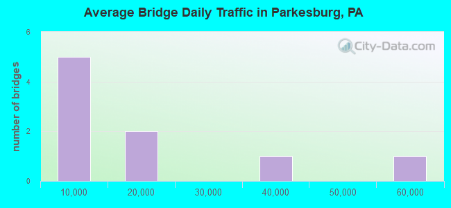
- 132,101Total average daily traffic
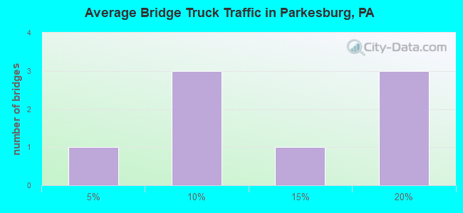
- 13,988Total average daily truck traffic
- National Bridge Inventory (NBI) Registered Bridges for Parkesburg
- No street view available for this location
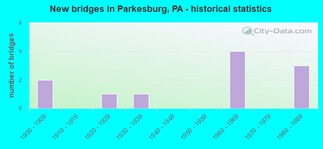
- New bridges - historical statistics
- 21900-1909
- 11920-1929
- 11930-1939
- 41960-1969
- 31980-1989
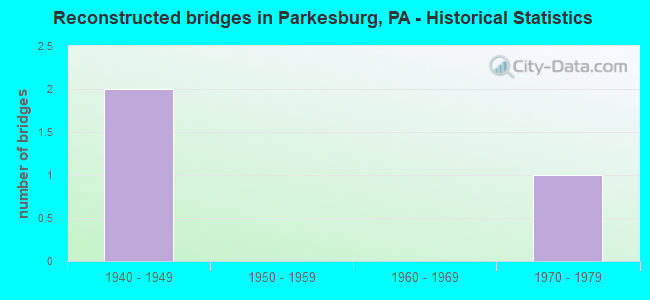
- Reconstructed bridges - Historical Statistics
- 21940-1949
- 01950-1959
- 01960-1969
- 11970-1979
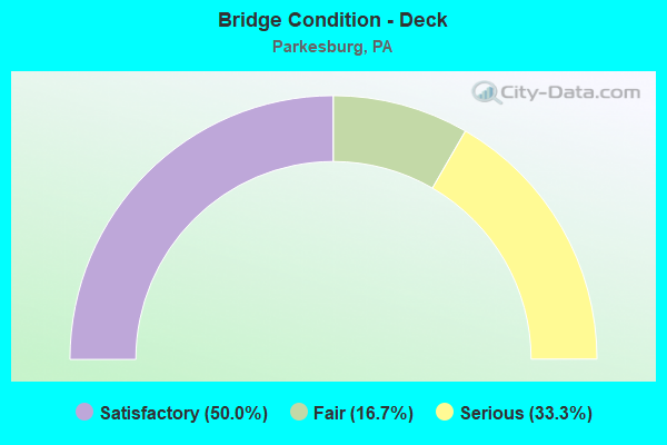
- Bridge Condition - Deck
- 50.0%Satisfactory
- 16.7%Fair
- 33.3%Serious
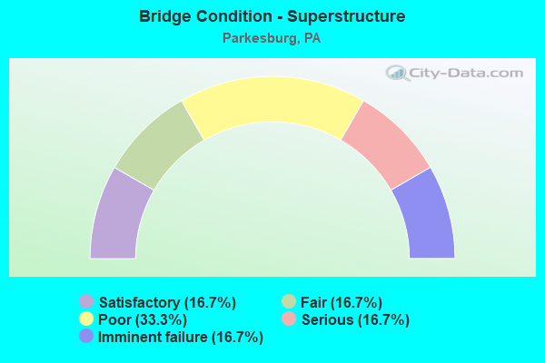
- Bridge Condition - Superstructure
- 16.7%Satisfactory
- 16.7%Fair
- 33.3%Poor
- 16.7%Serious
- 16.7%Imminent failure
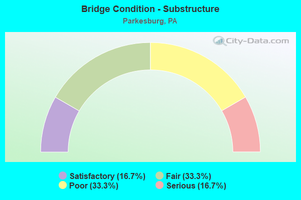
- Bridge Condition - Substructure
- 16.7%Satisfactory
- 33.3%Fair
- 33.3%Poor
- 16.7%Serious
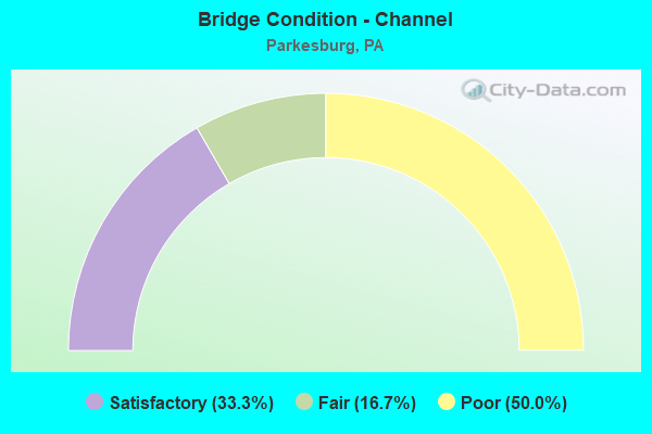
- Bridge Condition - Channel
- 33.3%Satisfactory
- 16.7%Fair
- 50.0%Poor
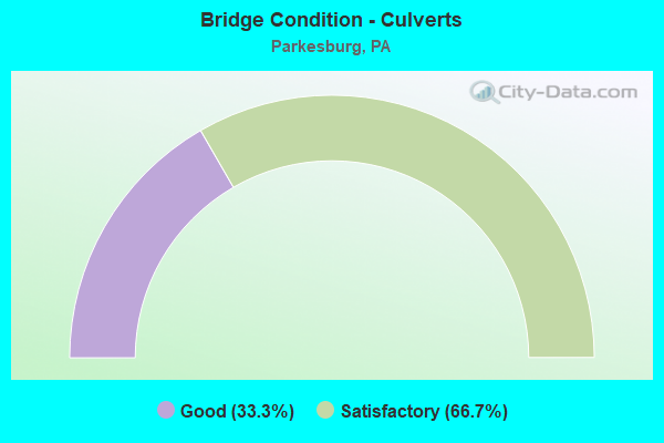
- Bridge Condition - Culverts
- 33.3%Good
- 66.7%Satisfactory
Find on map >> Show street view
Structure Number: 1087, Location: AT CAMP HORNE INTERCHANGE (Lat: 40.524369, Lng: -80.069642), Route carried "on" structure: Interstate 279, Year Built: 1987, Status: Open, Structure Length: 1.46m (4.79ft), Average Daily Traffic: 51,596 (year 2021), Truck Traffic: 6%, Average Future Daily Traffic: 38,287 (year 2032), Design Load: HS 20, Features Intersected: LOWRIES RUN, Facility Carried by Structure: RAYMOND E WILT HW
Minimum Vertical Clearance: 30+ m (98+ ft), Kilometerpoint: 12.875, Lanes on structure: 4, Base Highway Network: Yes, Owner: State Highway Agency, Approaching Roadway Width: 36.9m (121.1ft), Skew: 21 degrees, Material/Design: Concrete, Design/Construction: Culvert, Number Of Spans In Main Unit: 1, Length of Maximum Span: 13.4m (44.0ft)
Condition: Channel: Satisfactory, Culverts: Good, Operating Rating: 49.0 metric tons, Method Used To Determine Operating Rating: Field evaluation and documented engineering judgment, Inventory Rating: 32.7 metric tons, Method Used To Determine Inventory Rating: Field evaluation and documented engineering judgment, Structural Evaluation: Better than present minimum criteria, Waterway Adequacy: Superior to present desirable criteria, Approach Roadway Alignment: Equal to present desirable criteria, Length Of Structure Improvement: 2.10m (6.89ft), Designated Inspection Frequency: Every 48 months, Inspection Date: April 2018
Find on map >> Show street view
Structure Number: 9933, Location: S.E..PARKESBURG 27F10 (Lat: 39.956169, Lng: -75.912078), Route carried "on" structure: State highway 10, Year Built: 1986, Status: Open, Structure Length: 0.94m (3.08ft), Average Daily Traffic: 8,140 (year 2021), Truck Traffic: 11%, Average Future Daily Traffic: 9,945 (year 2032), Design Load: HS 25 or greater, Features Intersected: BRANCH BUCK RUN CREEK, Facility Carried by Structure: SOUTH CHURCH STR.
Minimum Vertical Clearance: 30+ m (98+ ft), Kilometerpoint: 21.342, Lanes on structure: 2, Owner: State Highway Agency, Approaching Roadway Width: 7.3m (24.0ft), Skew: 3 degrees, Material/Design: Concrete, Design/Construction: Culvert, Number Of Spans In Main Unit: 2, Length of Maximum Span: 4.3m (14.1ft), Curb-To-Curb Width: 9.2m (30.2ft), Out-to-Out Width: 10.3m (33.8ft)
Condition: Channel: Poor, Culverts: Satisfactory, Operating Rating: 55.3 metric tons, Method Used To Determine Operating Rating: Load Factor (LF), Inventory Rating: 32.7 metric tons, Method Used To Determine Inventory Rating: Load Factor (LF), Structural Evaluation: Equal to present minimum criteria, Deck Geometry: High priority of corrective action, Waterway Adequacy: Somewhat better than minimum adequacy, Approach Roadway Alignment: Equal to present desirable criteria, Length Of Structure Improvement: 1.60m (5.25ft), Designated Inspection Frequency: Every 24 months, Inspection Date: June 2021, Deck Structure Type: Concrete Cast-file-Place, Wearing Surface/Protective System: Wearing Surface: Bituminous, Deck Protection: Epoxy Coated Reinforcing
Find on map >> Show street view
Structure Number: 9934, Location: NR.MOBIL GAS STA. 27F9 (Lat: 39.960269, Lng: -75.913261), Route carried "on" structure: State highway 10, Year Built: 1985, Status: Open, Structure Length: 0.85m (2.79ft), Average Daily Traffic: 10,628 (year 2020), Truck Traffic: 17%, Average Future Daily Traffic: 17,961 (year 2032), Design Load: HS 20, Features Intersected: BRANCH BUCK RUN, Facility Carried by Structure: CHURCH ROAD
Minimum Vertical Clearance: 30+ m (98+ ft), Kilometerpoint: 21.879, Lanes on structure: 2, Owner: State Highway Agency, Approaching Roadway Width: 7.9m (25.9ft), Skew: 1 degrees, Material/Design: Concrete, Design/Construction: Culvert, Number Of Spans In Main Unit: 1, Length of Maximum Span: 4.9m (16.1ft)
Condition: Channel: Poor, Culverts: Satisfactory, Operating Rating: 45.4 metric tons, Method Used To Determine Operating Rating: Load Factor (LF), Inventory Rating: 27.2 metric tons, Method Used To Determine Inventory Rating: Load Factor (LF), Structural Evaluation: Equal to present minimum criteria, Waterway Adequacy: Equal to present minimum criteria, Approach Roadway Alignment: Equal to present desirable criteria, Length Of Structure Improvement: 1.20m (3.94ft), Designated Inspection Frequency: Every 24 months, Inspection Date: June 2021
Find on map >> Show street view
Structure Number: 9961, Location: N.OF COATESVILLE 27G05 (Lat: 39.984411, Lng: -75.910789), Route carried "on" structure: US 30, Year Built: 1961, Status: Open, Structure Length: 4.42m (14.50ft), Average Daily Traffic: 30,331 (year 2022), Truck Traffic: 15%, Average Future Daily Traffic: 36,132 (year 2032), Design Load: HS 20, Features Intersected: OLD MILL RD (T358) BUCK
Minimum Vertical Clearance: 30+ m (98+ ft), Kilometerpoint: 5.325, Lanes on structure: 4, Lanes under structure: 2, Base Highway Network: Yes, Owner: State Highway Agency, Approaching Roadway Width: 26.8m (87.9ft), Skew: 31 degrees, Material/Design: Prestressed concrete, Design/Construction: Stringer/Multi-beam, Number Of Spans In Main Unit: 3, Length of Maximum Span: 18.9m (62.0ft), Curb or Sidewalk Widths: Left: 0.1m (0.3ft), Right: 0.1m (0.3ft), Curb-To-Curb Width: 25.6m (84.0ft), Out-to-Out Width: 26.7m (87.6ft)
Condition: Deck: Satisfactory, Superstructure: Satisfactory, Substructure: Fair, Channel: Fair, Operating Rating: 67.1 metric tons, Method Used To Determine Operating Rating: Load Factor (LF), Inventory Rating: 30.8 metric tons, Method Used To Determine Inventory Rating: Load Factor (LF), Structural Evaluation: Somewhat better than minimum adequacy, Deck Geometry: Superior to present desirable criteria, Underclear: Better than present minimum criteria, Waterway Adequacy: Superior to present desirable criteria, Approach Roadway Alignment: Equal to present desirable criteria, Length Of Structure Improvement: 5.40m (17.72ft), Designated Inspection Frequency: Every 24 months, Inspection Date: August 2020, Bridge Improvement Cost: $91,000, Roadway Improvement Cost: $268,000, Total Project Cost: $1,230,000, Deck Structure Type: Concrete Cast-file-Place, Wearing Surface/Protective System: Wearing Surface: Bituminous
Find on map >> Show street view
Structure Number: 10548, Location: WEST COATESVILLE 27E5 (Lat: 39.982267, Lng: -75.919242), Route carried "on" structure: Business US 30B, Year Built: 1961, Status: Open, Structure Length: 2.74m (8.99ft), Average Daily Traffic: 7,796 (year 2021), Truck Traffic: 9%, Average Future Daily Traffic: 8,652 (year 2032), Design Load: HS 20, Features Intersected: RTE. 30 BY-PASS EB, Facility Carried by Structure: LINCOLN HIGHWAY
Minimum Vertical Clearance: 30+ m (98+ ft), Kilometerpoint: 0.000, Lanes on structure: 2, Lanes under structure: 2, Base Highway Network: Yes, Owner: State Highway Agency, Approaching Roadway Width: 20.7m (67.9ft), Skew: 6 degrees, Material/Design: Prestressed concrete, Design/Construction: Stringer/Multi-beam, Number Of Spans In Main Unit: 1, Length of Maximum Span: 25.9m (85.0ft), Curb or Sidewalk Widths: Left: 0.1m (0.3ft), Right: 0.1m (0.3ft), Curb-To-Curb Width: 21.0m (68.9ft), Out-to-Out Width: 21.8m (71.5ft)
Condition: Deck: Satisfactory, Superstructure: Fair, Substructure: Satisfactory, Operating Rating: 75.3 metric tons, Method Used To Determine Operating Rating: Load Factor (LF), Inventory Rating: 29.0 metric tons, Method Used To Determine Inventory Rating: Load Factor (LF), Structural Evaluation: Somewhat better than minimum adequacy, Deck Geometry: Superior to present desirable criteria, Underclear: High priority of corrective action, Approach Roadway Alignment: Equal to present desirable criteria, Length Of Structure Improvement: 3.40m (11.15ft), Designated Inspection Frequency: Every 24 months, Inspection Date: August 2020, Bridge Improvement Cost: $29,000, Roadway Improvement Cost: $86,000, Total Project Cost: $395,000, Deck Structure Type: Concrete Cast-file-Place, Wearing Surface/Protective System: Wearing Surface: Bituminous
Find on map >> Show street view
Structure Number: 10549, Location: NEAR COATESVILLE 27G5 (Lat: 39.981511, Lng: -75.908908), Route carried "on" structure: Business US 30B, Year Built: 1927, Status: Posted for load, Structure Length: 0.85m (2.79ft), Average Daily Traffic: 7,795 (year 2021), Truck Traffic: 9%, Average Future Daily Traffic: 8,650 (year 2032), Design Load: H 20, Features Intersected: BUCK RUN, Facility Carried by Structure: LINCOLN HIGHWAY
Minimum Vertical Clearance: 30+ m (98+ ft), Kilometerpoint: 0.958, Lanes on structure: 2, Base Highway Network: Yes, Owner: State Highway Agency, Approaching Roadway Width: 11.6m (38.1ft), Skew: 20 degrees, Material/Design: Concrete, Design/Construction: Tee Beam, Number Of Spans In Main Unit: 1, Length of Maximum Span: 7.3m (24.0ft), Curb-To-Curb Width: 14.8m (48.6ft), Out-to-Out Width: 15.8m (51.8ft)
Condition: Deck: Fair, Superstructure: Poor, Substructure: Poor, Channel: Satisfactory, Operating Rating: 49.9 metric tons, Method Used To Determine Operating Rating: Field evaluation and documented engineering judgment, Inventory Rating: 29.9 metric tons, Method Used To Determine Inventory Rating: Field evaluation and documented engineering judgment, Structural Evaluation: Meets minimum limits, Deck Geometry: Superior to present desirable criteria, Waterway Adequacy: Somewhat better than minimum adequacy, Approach Roadway Alignment: Equal to present desirable criteria, Length Of Structure Improvement: 1.40m (4.59ft), Designated Inspection Frequency: Every 24 months, Other Special Inspection Frequency: Every 12 months, Inspection Date: June 2020, Other Special Inspection Date: June 2021, Bridge Improvement Cost: $24,000, Roadway Improvement Cost: $71,000, Total Project Cost: $324,000, Deck Structure Type: Concrete Cast-file-Place, Wearing Surface/Protective System: Wearing Surface: Bituminous
Find on map >> Show street view
Structure Number: 1081, Location: 600' N OF RTE 30 3578-B3 (Lat: 39.984331, Lng: -75.926092), Route carried "on" structure: City street , Year Built: 1930, Year Reconstructed: 1970, Status: Open, Structure Length: 0.70m (2.30ft), Average Daily Traffic: 600 (year 2015), Truck Traffic: 2%, Average Future Daily Traffic: 750 (year 2035), Design Load: HS 20, Features Intersected: BUCK RUN, Facility Carried by Structure: COMPASS ROAD
Minimum Vertical Clearance: 30+ m (98+ ft), Kilometerpoint: 0.000, Lanes on structure: 2, Owner: Town or Township Highway Agency, Approaching Roadway Width: 4.9m (16.1ft), Material/Design: Steel, Design/Construction: Stringer/Multi-beam, Number Of Spans In Main Unit: 1, Length of Maximum Span: 6.4m (21.0ft), Curb-To-Curb Width: 4.2m (13.8ft), Out-to-Out Width: 5.5m (18.0ft)
Condition: Deck: Satisfactory, Superstructure: Poor, Substructure: Fair, Channel: Poor, Operating Rating: 49.9 metric tons, Method Used To Determine Operating Rating: Load Factor (LF), Inventory Rating: 29.9 metric tons, Method Used To Determine Inventory Rating: Load Factor (LF), Structural Evaluation: Meets minimum limits, Deck Geometry: High priority of replacement, Waterway Adequacy: Better than present minimum criteria, Approach Roadway Alignment: Equal to present desirable criteria, Length Of Structure Improvement: 0.60m (1.97ft), Designated Inspection Frequency: Every 24 months, Other Special Inspection Frequency: Every 12 months, Inspection Date: January 2020, Other Special Inspection Date: January 2021, Bridge Improvement Cost: $8,000, Roadway Improvement Cost: $65,000, Total Project Cost: $107,000, Deck Structure Type: Concrete Cast-file-Place, Wearing Surface/Protective System: Wearing Surface: Bituminous
Find on map >> Show street view
Structure Number: 1087, Location: PARKESBURG BORO 3578-B7 (Lat: 39.958800, Lng: -75.924658), Route carried "on" structure: City street , Year Built: 1903, Year Reconstructed: 1954, Status: Closed, Structure Length: 4.57m (14.99ft), Average Future Daily Traffic: 3,000 (year 2010), Features Intersected: AMTRAK RAILROAD, Facility Carried by Structure: EAST BRIDGE STREET
Minimum Vertical Clearance: 30+ m (98+ ft), Kilometerpoint: 0.000, Lanes on structure: 2, Owner: Town or Township Highway Agency, Approaching Roadway Width: 5.2m (17.1ft), Material/Design: Steel continuous, Design/Construction: Girder and Floorbeam System, Number Of Spans In Main Unit: 4, Length of Maximum Span: 12.8m (42.0ft), Curb or Sidewalk Widths: Left: 1.8m (5.9ft), Right: 1.8m (5.9ft), Curb-To-Curb Width: 5.9m (19.4ft), Out-to-Out Width: 10.4m (34.1ft)
Condition: Deck: Serious, Superstructure: Serious, Substructure: Serious, Deck Geometry: Meets minimum limits, Approach Roadway Alignment: Better than present minimum criteria, Bridge Posting: Required (Relationship of Operating Rating to Maximum Legal Load: > 39.9% below), Length Of Structure Improvement: 5.60m (18.37ft), Designated Inspection Frequency: Every 24 months, Inspection Date: November 2020, Bridge Improvement Cost: $102,000, Roadway Improvement Cost: $299,000, Total Project Cost: $1,371,000, Deck Structure Type: Wood or Timber, Wearing Surface/Protective System: Wearing Surface: Bituminous
Find on map >> Show street view
Structure Number: 10871, Location: BOROUGH PARKSBURG 3578-B7 (Lat: 39.958400, Lng: -75.926217), Route carried "on" structure: City street , Year Built: 1903, Year Reconstructed: 1954, Status: Closed, Structure Length: 5.24m (17.19ft), Features Intersected: AMTRAK, Facility Carried by Structure: WEST BRIDGE STREET
Minimum Vertical Clearance: 30+ m (98+ ft), Kilometerpoint: 0.000, Lanes on structure: 2, Owner: Town or Township Highway Agency, Approaching Roadway Width: 5.8m (19.0ft), Material/Design: Steel continuous, Design/Construction: Girder and Floorbeam System, Number Of Spans In Main Unit: 4, Length of Maximum Span: 14.0m (45.9ft), Curb or Sidewalk Widths: Left: 1.8m (5.9ft), Right: 1.8m (5.9ft), Curb-To-Curb Width: 5.8m (19.0ft), Out-to-Out Width: 10.4m (34.1ft)
Condition: Deck: Serious, Superstructure: Imminent failure, Substructure: Poor, Deck Geometry: Meets minimum limits, Approach Roadway Alignment: Better than present minimum criteria, Bridge Posting: Required (Relationship of Operating Rating to Maximum Legal Load: > 39.9% below), Length Of Structure Improvement: 6.60m (21.65ft), Designated Inspection Frequency: Every 24 months, Inspection Date: November 2020, Bridge Improvement Cost: $130,000, Roadway Improvement Cost: $383,000, Total Project Cost: $1,755,000, Deck Structure Type: Wood or Timber, Wearing Surface/Protective System: Wearing Surface: Bituminous
Find on map >> Show street view
Structure Number: 9961, Location: N.OF COATESVILLE 27G05 (Lat: 39.984411, Lng: -75.910789), Route carried "under" structure: State highway , Year Built: 1961, Structure Length: 0. m, Average Daily Traffic: 350 (year 1980), Features Intersected: OLD MILL RD (T358) BUCK, Facility Carried by Structure: ROUTE 30 BY-PASS
Minimum Vertical Clearance: 4.88m (16.01ft), Kilometerpoint: 0.000, Lanes on structure: 4, Lanes under structure: 2, Material/Design: Prestressed concrete, Design/Construction: Stringer/Multi-beam, Length of Maximum Span: 18.9m (62.0ft)
Find on map >> Show street view
Structure Number: 10548, Location: WEST COATESVILLE 27E5 (Lat: 39.982267, Lng: -75.919242), Route carried "under" structure: US 30, Year Built: 1961, Structure Length: 0. m, Average Daily Traffic: 14,865 (year 2022), Truck Traffic: 15%, Features Intersected: RTE. 30 BY-PASS EB, Facility Carried by Structure: LINCOLN HIGHWAY
Minimum Vertical Clearance: 4.44m (14.57ft), Kilometerpoint: 4.600, Lanes on structure: 2, Lanes under structure: 2, Material/Design: Prestressed concrete, Design/Construction: Stringer/Multi-beam, Length of Maximum Span: 25.9m (85.0ft)