Bridge Statistics for Perris, California (CA)
Condition, Traffic, Stress, Structural Evaluation, Project Costs
- National Bridge Inventory (NBI) Statistics
- 40Number of bridges
- 482ft / 147mTotal length
- 1,659,472Total average daily traffic
- 168,949Total average daily truck traffic
- National Bridge Inventory (NBI) Registered Bridges for Perris
- No street view available for this location
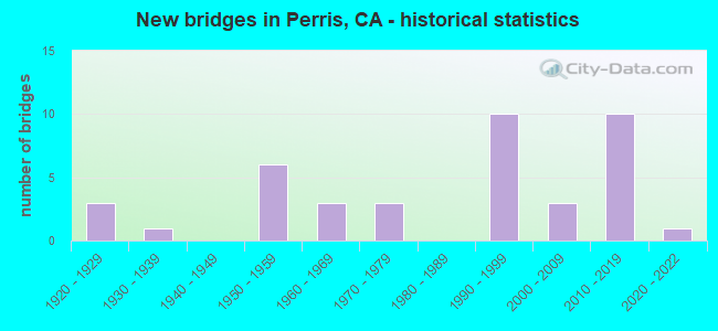
- New bridges - historical statistics
- 31920-1929
- 11930-1939
- 61950-1959
- 31960-1969
- 31970-1979
- 101990-1999
- 32000-2009
- 102010-2019
- 12020-2022
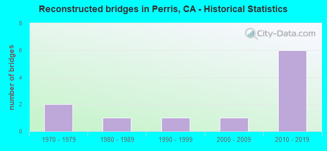
- Reconstructed bridges - Historical Statistics
- 21970-1979
- 11980-1989
- 11990-1999
- 12000-2009
- 62010-2019
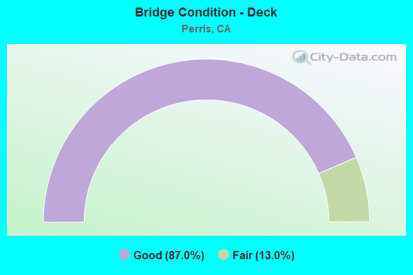
- Bridge Condition - Deck
- 87.0%Good
- 13.0%Fair
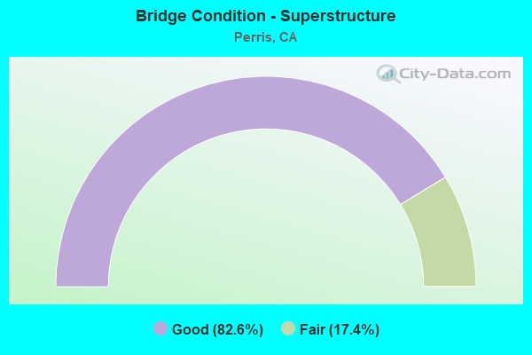
- Bridge Condition - Superstructure
- 82.6%Good
- 17.4%Fair
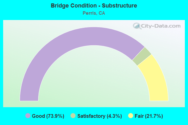
- Bridge Condition - Substructure
- 73.9%Good
- 4.3%Satisfactory
- 21.7%Fair
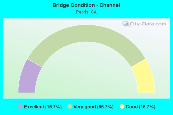
- Bridge Condition - Channel
- 16.7%Excellent
- 66.7%Very good
- 16.7%Good
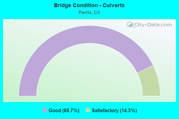
- Bridge Condition - Culverts
- 85.7%Good
- 14.3%Satisfactory
Find on map >> Show street view
Structure Number: 56 017, Location: 08-RIV-074-3.50 (Lat: 33.620914, Lng: -117.423906), Route carried "on" structure: State highway 74, Year Built: 1931, Year Reconstructed: 1990, Status: Open, Structure Length: 0.76m (2.49ft), Average Daily Traffic: 8,600 (year 2020), Truck Traffic: 7%, Average Future Daily Traffic: 19,916 (year 2041), Design Load: H 15, Features Intersected: DECKER CANYON
Minimum Vertical Clearance: 30+ m (98+ ft), Kilometerpoint: 3.500, Lanes on structure: 2, Base Highway Network: Yes (, Subroute: 1), Owner: State Highway Agency, Approaching Roadway Width: 12.2m (40.0ft), Skew: 1 degrees, Material/Design: Masonry, Design/Construction: Arch - Deck, Number Of Spans In Main Unit: 1, Length of Maximum Span: 7.6m (24.9ft), Curb-To-Curb Width: 12.2m (40.0ft), Out-to-Out Width: 12.8m (42.0ft)
Condition: Deck: Good, Superstructure: Fair, Substructure: Fair, Channel: Very good, Operating Rating: 40.5 metric tons, Method Used To Determine Operating Rating: Field evaluation and documented engineering judgment, Inventory Rating: 24.3 metric tons, Method Used To Determine Inventory Rating: Field evaluation and documented engineering judgment, Structural Evaluation: Somewhat better than minimum adequacy, Deck Geometry: Somewhat better than minimum adequacy, Waterway Adequacy: Equal to present desirable criteria, Approach Roadway Alignment: High priority of corrective action, Designated Inspection Frequency: Every 24 months, Inspection Date: July 2021
Find on map >> Show street view
Structure Number: 56 0175, Location: 08-RIV-215-23.51-PER (Lat: 33.753839, Lng: -117.189367), Route carried "on" structure: State highway 215, Year Built: 1962, Year Reconstructed: 2016, Status: Open, Structure Length: 7.53m (24.70ft), Average Daily Traffic: 72,000 (year 2009), Truck Traffic: 12%, Average Future Daily Traffic: 139,567 (year 2038), Design Load: HS 20, Features Intersected: ST RTE 74, BNSF RY, RCTC
Minimum Vertical Clearance: 30+ m (98+ ft), Kilometerpoint: 23.510, Lanes on structure: 7, Lanes under structure: 3, Base Highway Network: Yes (Inventory Route: 2, Subroute: 1), Owner: State Highway Agency, Approaching Roadway Width: 39.0m (128.0ft), Skew: 3 degrees, Material/Design: Concrete continuous, Design/Construction: Stringer/Multi-beam, Number Of Spans In Main Unit: 4, Length of Maximum Span: 26.8m (87.9ft), Curb-To-Curb Width: 39.0m (128.0ft), Out-to-Out Width: 40.5m (132.9ft)
Condition: Deck: Good, Superstructure: Good, Substructure: Good, Operating Rating: 66.4 metric tons, Method Used To Determine Operating Rating: Load Factor (LF), Inventory Rating: 40.2 metric tons, Method Used To Determine Inventory Rating: Load Factor (LF), Structural Evaluation: Better than present minimum criteria, Deck Geometry: Superior to present desirable criteria, Underclear: Meets minimum limits, Approach Roadway Alignment: Equal to present desirable criteria, Designated Inspection Frequency: Every 48 months, Inspection Date: September 2018, Deck Structure Type: Concrete Cast-file-Place
Find on map >> Show street view
Structure Number: 56 029, Location: 08-RIV-111-11.03 (Lat: 33.533158, Lng: -115.964781), Route carried "on" structure: State highway 111, Year Built: 1951, Year Reconstructed: 1987, Status: Open, Structure Length: 0.98m (3.22ft), Average Daily Traffic: 2,700 (year 2012), Truck Traffic: 11%, Average Future Daily Traffic: 4,263 (year 2038), Design Load: HS 20, Features Intersected: OAK DITCH
Minimum Vertical Clearance: 30+ m (98+ ft), Kilometerpoint: 11.030, Lanes on structure: 2, Base Highway Network: Yes (Inventory Route: 1, Subroute: 1), Owner: State Highway Agency, Approaching Roadway Width: 9.8m (32.2ft), Material/Design: Concrete, Design/Construction: Culvert, Number Of Spans In Main Unit: 3, Length of Maximum Span: 3.4m (11.2ft), Curb-To-Curb Width: 9.8m (32.2ft), Out-to-Out Width: 15.8m (51.8ft)
Condition: Channel: Good, Culverts: Good, Operating Rating: 64.8 metric tons, Method Used To Determine Operating Rating: Load Factor (LF), Inventory Rating: 39.2 metric tons, Method Used To Determine Inventory Rating: Load Factor (LF), Structural Evaluation: Better than present minimum criteria, Deck Geometry: Meets minimum limits, Waterway Adequacy: Equal to present desirable criteria, Approach Roadway Alignment: Equal to present desirable criteria, Designated Inspection Frequency: Every 48 months, Inspection Date: May 2021
Find on map >> Show street view
Structure Number: 56 0295, Location: 08-RIV-215-24.91-PER (Lat: 33.771381, Lng: -117.196858), Route carried "on" structure: State highway 215, Year Built: 1953, Year Reconstructed: 2015, Status: Open, Structure Length: 0.94m (3.08ft), Average Daily Traffic: 88,000 (year 2016), Truck Traffic: 12%, Average Future Daily Traffic: 139,567 (year 2038), Design Load: HS 20, Features Intersected: SAN JACINTO RIV OVERFLOW
Minimum Vertical Clearance: 30+ m (98+ ft), Kilometerpoint: 24.910, Lanes on structure: 6, Base Highway Network: Yes (Inventory Route: 2, Subroute: 1), Owner: State Highway Agency, Approaching Roadway Width: 34.1m (111.9ft), Skew: 30 degrees, Material/Design: Concrete, Design/Construction: Slab, Number Of Spans In Main Unit: 1, Length of Maximum Span: 8.5m (27.9ft), Curb-To-Curb Width: 34.1m (111.9ft), Out-to-Out Width: 35.7m (117.1ft)
Condition: Deck: Good, Superstructure: Good, Substructure: Good, Channel: Very good, Operating Rating: 57.3 metric tons, Method Used To Determine Operating Rating: Load Factor (LF), Inventory Rating: 34.7 metric tons, Method Used To Determine Inventory Rating: Load Factor (LF), Structural Evaluation: Better than present minimum criteria, Deck Geometry: Superior to present desirable criteria, Waterway Adequacy: Equal to present desirable criteria, Approach Roadway Alignment: Equal to present desirable criteria, Designated Inspection Frequency: Every 48 months, Inspection Date: September 2018, Deck Structure Type: Concrete Cast-file-Place, Wearing Surface/Protective System: Wearing Surface: Bituminous
Find on map >> Show street view
Structure Number: 56 0296, Location: 08-RIV-215-25.10-PER (Lat: 33.773142, Lng: -117.199547), Route carried "on" structure: State highway 215, Year Built: 1953, Year Reconstructed: 2015, Status: Open, Structure Length: 4.97m (16.31ft), Average Daily Traffic: 72,000 (year 2010), Truck Traffic: 12%, Average Future Daily Traffic: 139,567 (year 2038), Design Load: HS 20, Features Intersected: SAN JACINTO RIVER
Minimum Vertical Clearance: 30+ m (98+ ft), Kilometerpoint: 25.100, Lanes on structure: 6, Base Highway Network: Yes (Inventory Route: 2, Subroute: 1), Owner: State Highway Agency, Approaching Roadway Width: 34.1m (111.9ft), Skew: 30 degrees, Material/Design: Concrete continuous, Design/Construction: Slab, Number Of Spans In Main Unit: 4, Length of Maximum Span: 12.2m (40.0ft), Curb-To-Curb Width: 34.1m (111.9ft), Out-to-Out Width: 35.7m (117.1ft)
Condition: Deck: Good, Superstructure: Good, Substructure: Good, Channel: Very good, Operating Rating: 75.8 metric tons, Method Used To Determine Operating Rating: Load Factor (LF), Inventory Rating: 45.7 metric tons, Method Used To Determine Inventory Rating: Load Factor (LF), Structural Evaluation: Better than present minimum criteria, Deck Geometry: Superior to present desirable criteria, Waterway Adequacy: Equal to present desirable criteria, Approach Roadway Alignment: Equal to present desirable criteria, Designated Inspection Frequency: Every 48 months, Inspection Date: August 2020, Deck Structure Type: Concrete Cast-file-Place, Wearing Surface/Protective System: Wearing Surface: Bituminous
Find on map >> Show street view
Structure Number: 56 0297, Location: 08-RIV-215-25.32-PER (Lat: 33.775122, Lng: -117.202550), Route carried "on" structure: State highway 215, Year Built: 1953, Year Reconstructed: 2015, Status: Open, Structure Length: 0.94m (3.08ft), Average Daily Traffic: 88,000 (year 2016), Truck Traffic: 12%, Average Future Daily Traffic: 139,567 (year 2038), Design Load: HS 20, Features Intersected: SAN JACINTO RIV OVERFLOW
Minimum Vertical Clearance: 30+ m (98+ ft), Kilometerpoint: 25.320, Lanes on structure: 6, Base Highway Network: Yes (Inventory Route: 2, Subroute: 1), Owner: State Highway Agency, Approaching Roadway Width: 34.1m (111.9ft), Skew: 30 degrees, Material/Design: Concrete, Design/Construction: Slab, Number Of Spans In Main Unit: 1, Length of Maximum Span: 8.5m (27.9ft), Curb-To-Curb Width: 34.1m (111.9ft), Out-to-Out Width: 35.7m (117.1ft)
Condition: Deck: Good, Superstructure: Good, Substructure: Good, Channel: Very good, Operating Rating: 60.3 metric tons, Method Used To Determine Operating Rating: Load Factor (LF), Inventory Rating: 36.3 metric tons, Method Used To Determine Inventory Rating: Load Factor (LF), Structural Evaluation: Better than present minimum criteria, Deck Geometry: Superior to present desirable criteria, Waterway Adequacy: Equal to present desirable criteria, Approach Roadway Alignment: Equal to present desirable criteria, Designated Inspection Frequency: Every 48 months, Inspection Date: September 2018, Deck Structure Type: Concrete Cast-file-Place, Wearing Surface/Protective System: Wearing Surface: Bituminous
Find on map >> Show street view
Structure Number: 56 0720L, Location: 08-RIV-015-10.59 (Lat: 33.565283, Lng: -117.206928), Route carried "on" structure: Interstate 15, Year Built: 1979, Year Reconstructed: 2012, Status: Open, Structure Length: 3.90m (12.80ft), Average Daily Traffic: 130,000 (year 2021), Truck Traffic: 7%, Average Future Daily Traffic: 223,691 (year 2039), Design Load: HS 20+Mod, Features Intersected: CALIFORNIA OAKS RD
Minimum Vertical Clearance: 30+ m (98+ ft), Kilometerpoint: 10.590, Lanes on structure: 4, Lanes under structure: 6, Base Highway Network: Yes (, Subroute: 1), Owner: State Highway Agency, Approaching Roadway Width: 21.6m (70.9ft), Skew: 1 degrees, Material/Design: Prestressed concrete, Design/Construction: Box Beam or Girders - Multiple, Number Of Spans In Main Unit: 1, Length of Maximum Span: 39.0m (128.0ft), Curb-To-Curb Width: 21.6m (70.9ft), Out-to-Out Width: 22.7m (74.5ft)
Condition: Deck: Good, Superstructure: Good, Substructure: Good, Operating Rating: 54.1 metric tons, Method Used To Determine Operating Rating: Assigned rating based on Load Factor Design (LFD) reported in metric tons, Inventory Rating: 32.4 metric tons, Method Used To Determine Inventory Rating: Assigned rating based on Load Factor Design (LFD) reported in metric tons, Structural Evaluation: Better than present minimum criteria, Deck Geometry: Better than present minimum criteria, Underclear: Equal to present minimum criteria, Approach Roadway Alignment: Superior to present desirable criteria, Designated Inspection Frequency: Every 24 months, Inspection Date: December 2021, Deck Structure Type: Concrete Cast-file-Place
Find on map >> Show street view
Structure Number: 56 0729, Location: 08-RIV-215-22.76-PER (Lat: 33.742864, Lng: -117.189786), Route carried "on" structure: City street , Year Built: 1992, Status: Open, Structure Length: 6.71m (22.01ft), Average Daily Traffic: 36,000 (year 2012), Truck Traffic: 7%, Average Future Daily Traffic: 70,000 (year 2038), Design Load: HS 20+Mod, Features Intersected: INTERSTATE 215, Facility Carried by Structure: ETHANAC ROAD
Minimum Vertical Clearance: 30+ m (98+ ft), Kilometerpoint: 0.000, Lanes on structure: 4, Lanes under structure: 6, Base Highway Network: Yes, Owner: State Highway Agency, Approaching Roadway Width: 23.2m (76.1ft), Material/Design: Prestressed concrete continuous, Design/Construction: Box Beam or Girders - Multiple, Number Of Spans In Main Unit: 2, Length of Maximum Span: 32.9m (107.9ft), Curb or Sidewalk Widths: Left: 0.0m, Right: 1.5m (4.9ft), Curb-To-Curb Width: 23.2m (76.1ft), Out-to-Out Width: 25.5m (83.7ft)
Condition: Deck: Good, Superstructure: Fair, Substructure: Good, Operating Rating: 54.1 metric tons, Method Used To Determine Operating Rating: Assigned rating based on Load Factor Design (LFD) reported in metric tons, Inventory Rating: 32.4 metric tons, Method Used To Determine Inventory Rating: Assigned rating based on Load Factor Design (LFD) reported in metric tons, Structural Evaluation: Somewhat better than minimum adequacy, Deck Geometry: Superior to present desirable criteria, Underclear: Meets minimum limits, Approach Roadway Alignment: Superior to present desirable criteria, Designated Inspection Frequency: Every 24 months, Inspection Date: August 2020, Deck Structure Type: Concrete Cast-file-Place
Find on map >> Show street view
Structure Number: 56 0760L, Location: 08-RIV-086-R22.16-COA (Lat: 33.707658, Lng: -116.181172), Route carried "on" structure: State highway 86, Year Built: 1993, Status: Open, Structure Length: 5.52m (18.11ft), Average Daily Traffic: 13,500 (year 2012), Truck Traffic: 21%, Average Future Daily Traffic: 16,777 (year 2038), Design Load: HS 20+Mod, Features Intersected: DILLON ROAD
Minimum Vertical Clearance: 30+ m (98+ ft), Kilometerpoint: 22.160, Lanes on structure: 2, Lanes under structure: 4, Base Highway Network: Yes (Inventory Route: 8, Subroute: 1), Owner: State Highway Agency, Approaching Roadway Width: 11.9m (39.0ft), Material/Design: Prestressed concrete continuous, Design/Construction: Box Beam or Girders - Single/Spread, Number Of Spans In Main Unit: 2, Number Of Approach Spans: 2, Length of Maximum Span: 27.1m (88.9ft), Curb-To-Curb Width: 11.9m (39.0ft), Out-to-Out Width: 12.9m (42.3ft)
Condition: Deck: Good, Superstructure: Good, Substructure: Fair, Operating Rating: 54.1 metric tons, Method Used To Determine Operating Rating: Assigned rating based on Load Factor Design (LFD) reported in metric tons, Inventory Rating: 32.4 metric tons, Method Used To Determine Inventory Rating: Assigned rating based on Load Factor Design (LFD) reported in metric tons, Structural Evaluation: Somewhat better than minimum adequacy, Deck Geometry: Equal to present minimum criteria, Underclear: Better than present minimum criteria, Approach Roadway Alignment: Equal to present desirable criteria, Designated Inspection Frequency: Every 24 months, Inspection Date: April 2021, Deck Structure Type: Concrete Cast-file-Place
Find on map >> Show street view
Structure Number: 56 0761, Location: 08-RIV-215-R28.00-PER (Lat: 33.802561, Lng: -117.233072), Route carried "on" structure: County highway W550, Year Built: 1994, Status: Open, Structure Length: 7.91m (25.95ft), Average Daily Traffic: 10,554 (year 2011), Truck Traffic: 3%, Average Future Daily Traffic: 17,000 (year 2038), Design Load: HS 20, Features Intersected: INTERSTATE 215, Facility Carried by Structure: NUEVO ROAD
Minimum Vertical Clearance: 30+ m (98+ ft), Kilometerpoint: 0.000, Lanes on structure: 5, Lanes under structure: 6, Owner: State Highway Agency, Approaching Roadway Width: 23.2m (76.1ft), Skew: 3 degrees, Material/Design: Prestressed concrete continuous, Design/Construction: Box Beam or Girders - Multiple, Number Of Spans In Main Unit: 2, Length of Maximum Span: 42.4m (139.1ft), Curb or Sidewalk Widths: Left: 1.5m (4.9ft), Right: 1.5m (4.9ft), Curb-To-Curb Width: 23.2m (76.1ft), Out-to-Out Width: 26.8m (87.9ft)
Condition: Deck: Fair, Superstructure: Fair, Substructure: Good, Operating Rating: 54.1 metric tons, Method Used To Determine Operating Rating: Assigned rating based on Load Factor Design (LFD) reported in metric tons, Inventory Rating: 32.4 metric tons, Method Used To Determine Inventory Rating: Assigned rating based on Load Factor Design (LFD) reported in metric tons, Structural Evaluation: Somewhat better than minimum adequacy, Deck Geometry: Better than present minimum criteria, Underclear: Meets minimum limits, Approach Roadway Alignment: Equal to present desirable criteria, Designated Inspection Frequency: Every 24 months, Inspection Date: August 2020, Deck Structure Type: Concrete Cast-file-Place
Find on map >> Show street view
Structure Number: 56 0763, Location: 08-RIV-215-R29.50-PER (Lat: 33.823064, Lng: -117.241608), Route carried "on" structure: County highway , Year Built: 1994, Status: Open, Structure Length: 6.61m (21.69ft), Average Daily Traffic: 4,140 (year 2012), Truck Traffic: 3%, Average Future Daily Traffic: 6,700 (year 2038), Design Load: HS 20, Features Intersected: INTERSTATE 215, Facility Carried by Structure: PLACENTIA AVE
Minimum Vertical Clearance: 30+ m (98+ ft), Kilometerpoint: 0.000, Lanes on structure: 5, Lanes under structure: 6, Owner: State Highway Agency, Approaching Roadway Width: 19.5m (64.0ft), Skew: 2 degrees, Material/Design: Prestressed concrete continuous, Design/Construction: Box Beam or Girders - Multiple, Number Of Spans In Main Unit: 2, Length of Maximum Span: 34.4m (112.9ft), Curb or Sidewalk Widths: Left: 1.5m (4.9ft), Right: 3.0m (9.8ft), Curb-To-Curb Width: 19.5m (64.0ft), Out-to-Out Width: 25.2m (82.7ft)
Condition: Deck: Good, Superstructure: Fair, Substructure: Fair, Operating Rating: 54.1 metric tons, Method Used To Determine Operating Rating: Assigned rating based on Load Factor Design (LFD) reported in metric tons, Inventory Rating: 32.4 metric tons, Method Used To Determine Inventory Rating: Assigned rating based on Load Factor Design (LFD) reported in metric tons, Structural Evaluation: Somewhat better than minimum adequacy, Deck Geometry: Meets minimum limits, Underclear: Equal to present minimum criteria, Approach Roadway Alignment: Equal to present desirable criteria, Designated Inspection Frequency: Every 24 months, Inspection Date: August 2020, Deck Structure Type: Concrete Cast-file-Place
Find on map >> Show street view
Structure Number: 56 0765, Location: 08-RIV-215-R32.30-PER (Lat: 33.862469, Lng: -117.260006), Route carried "on" structure: County highway , Year Built: 1994, Status: Open, Structure Length: 6.58m (21.59ft), Average Daily Traffic: 13,900 (year 2015), Truck Traffic: 7%, Average Future Daily Traffic: 17,000 (year 2040), Design Load: HS 20+Mod, Features Intersected: INTERSTATE 215, Facility Carried by Structure: HARLEY KNOX BLVD
Minimum Vertical Clearance: 5.49m (18.01ft), Kilometerpoint: 0.000, Lanes on structure: 5, Lanes under structure: 6, Owner: State Highway Agency, Approaching Roadway Width: 23.2m (76.1ft), Skew: 1 degrees, Material/Design: Prestressed concrete continuous, Design/Construction: Box Beam or Girders - Multiple, Number Of Spans In Main Unit: 2, Length of Maximum Span: 32.9m (107.9ft), Curb or Sidewalk Widths: Left: 1.5m (4.9ft), Right: 1.5m (4.9ft), Curb-To-Curb Width: 23.2m (76.1ft), Out-to-Out Width: 26.8m (87.9ft)
Condition: Deck: Good, Superstructure: Good, Substructure: Good, Operating Rating: 54.1 metric tons, Method Used To Determine Operating Rating: Assigned rating based on Load Factor Design (LFD) reported in metric tons, Inventory Rating: 32.4 metric tons, Method Used To Determine Inventory Rating: Assigned rating based on Load Factor Design (LFD) reported in metric tons, Structural Evaluation: Better than present minimum criteria, Deck Geometry: Better than present minimum criteria, Underclear: Equal to present minimum criteria, Approach Roadway Alignment: Equal to present desirable criteria, Designated Inspection Frequency: Every 24 months, Inspection Date: April 2021, Deck Structure Type: Concrete Cast-file-Place
Find on map >> Show street view
Structure Number: 56 0770R, Location: 08-RIV-215-22.33 (Lat: 33.736669, Lng: -117.189103), Route carried "on" structure: State highway 215, Year Built: 1992, Year Reconstructed: 2015, Status: Open, Structure Length: 3.90m (12.80ft), Average Daily Traffic: 37,000 (year 2010), Truck Traffic: 5%, Average Future Daily Traffic: 70,691 (year 2038), Design Load: HS 20, Features Intersected: ROMOLAND FLOOD CNTL CHNL
Minimum Vertical Clearance: 30+ m (98+ ft), Kilometerpoint: 22.330, Lanes on structure: 3, Base Highway Network: Yes (Inventory Route: 2, Subroute: 1), Owner: State Highway Agency, Approaching Roadway Width: 17.1m (56.1ft), Material/Design: Concrete continuous, Design/Construction: Slab, Number Of Spans In Main Unit: 4, Length of Maximum Span: 9.8m (32.2ft), Curb-To-Curb Width: 17.1m (56.1ft), Out-to-Out Width: 18.0m (59.1ft)
Condition: Deck: Good, Superstructure: Good, Substructure: Good, Channel: Very good, Operating Rating: 54.1 metric tons, Method Used To Determine Operating Rating: Assigned rating based on Load Factor Design (LFD) reported in metric tons, Inventory Rating: 32.4 metric tons, Method Used To Determine Inventory Rating: Assigned rating based on Load Factor Design (LFD) reported in metric tons, Structural Evaluation: Better than present minimum criteria, Deck Geometry: Equal to present minimum criteria, Waterway Adequacy: Equal to present desirable criteria, Approach Roadway Alignment: Superior to present desirable criteria, Designated Inspection Frequency: Every 48 months, Inspection Date: August 2020, Deck Structure Type: Concrete Cast-file-Place
Find on map >> Show street view
Structure Number: 56 084, Location: 08-RIV-091-18.98-RIV (Lat: 33.959811, Lng: -117.377739), Route carried "on" structure: City street , Year Built: 2015, Status: Open, Structure Length: 5.09m (16.70ft), Average Daily Traffic: 1,450 (year 2020), Truck Traffic: 2%, Average Future Daily Traffic: 1,800 (year 2041), Design Load: HL 93, Features Intersected: ROUTE 91, Facility Carried by Structure: IVY STREET
Minimum Vertical Clearance: 30+ m (98+ ft), Kilometerpoint: 0.000, Lanes on structure: 2, Lanes under structure: 9, Owner: State Highway Agency, Approaching Roadway Width: 10.3m (33.8ft), Material/Design: Prestressed concrete continuous, Design/Construction: Stringer/Multi-beam, Number Of Spans In Main Unit: 2, Length of Maximum Span: 26.6m (87.3ft), Curb or Sidewalk Widths: Left: 0.0m, Right: 1.5m (4.9ft), Curb-To-Curb Width: 10.3m (33.8ft), Out-to-Out Width: 12.6m (41.3ft)
Condition: Deck: Good, Superstructure: Good, Substructure: Good, Operating Rating: 42.1 metric tons, Method Used To Determine Operating Rating: Assigned ratings based on Load and Resistance Factor Design (LRFD) reported by rating factor (RF) using HL93 loadings, Inventory Rating: 32.4 metric tons, Method Used To Determine Inventory Rating: Assigned ratings based on Load and Resistance Factor Design (LRFD) reported by rating factor (RF) using HL93 loadings, Structural Evaluation: Better than present minimum criteria, Deck Geometry: Somewhat better than minimum adequacy, Underclear: Meets minimum limits, Approach Roadway Alignment: Meets minimum limits, Designated Inspection Frequency: Every 48 months, Inspection Date: December 2021, Deck Structure Type: Concrete Precast Panels
Find on map >> Show street view
Structure Number: 56 0846, Location: 08-RIV-215-R34.25-PER (Lat: 33.887867, Lng: -117.270392), Route carried "on" structure: County highway , Year Built: 2014, Status: Open, Structure Length: 9.56m (31.36ft), Average Daily Traffic: 30,000 (year 2015), Truck Traffic: 2%, Average Future Daily Traffic: 36,000 (year 2038), Design Load: HL 93, Features Intersected: INTERSTATE 215, Facility Carried by Structure: VAN BUREN BLVD
Minimum Vertical Clearance: 5.49m (18.01ft), Kilometerpoint: 0.000, Lanes on structure: 5, Lanes under structure: 6, Owner: State Highway Agency, Approaching Roadway Width: 26.8m (87.9ft), Skew: 2 degrees, Material/Design: Prestressed concrete continuous, Design/Construction: Box Beam or Girders - Multiple, Number Of Spans In Main Unit: 2, Length of Maximum Span: 55.0m (180.4ft), Curb or Sidewalk Widths: Left: 0.0m, Right: 2.4m (7.9ft), Curb-To-Curb Width: 26.8m (87.9ft), Out-to-Out Width: 30.0m (98.4ft)
Condition: Deck: Good, Superstructure: Good, Substructure: Good, Operating Rating: 42.1 metric tons, Method Used To Determine Operating Rating: Assigned ratings based on Load and Resistance Factor Design (LRFD) reported by rating factor (RF) using HL93 loadings, Inventory Rating: 32.4 metric tons, Method Used To Determine Inventory Rating: Assigned ratings based on Load and Resistance Factor Design (LRFD) reported by rating factor (RF) using HL93 loadings, Structural Evaluation: Better than present minimum criteria, Deck Geometry: Superior to present desirable criteria, Underclear: Somewhat better than minimum adequacy, Approach Roadway Alignment: Equal to present desirable criteria, Designated Inspection Frequency: Every 24 months, Inspection Date: August 2020, Deck Structure Type: Concrete Cast-file-Place
Find on map >> Show street view
Structure Number: 56 0847, Location: 08-RIV-074-27.51 (Lat: 33.783672, Lng: -117.216456), Route carried "on" structure: State highway 74, Year Built: 2011, Status: Open, Structure Length: 7.34m (24.08ft), Average Daily Traffic: 26,000 (year 2012), Truck Traffic: 12%, Average Future Daily Traffic: 38,536 (year 2040), Design Load: HL 93, Features Intersected: INTERSTATE 215
Minimum Vertical Clearance: 30+ m (98+ ft), Kilometerpoint: 27.510, Lanes on structure: 8, Lanes under structure: 4, Base Highway Network: Yes (, Subroute: 1), Owner: State Highway Agency, Approaching Roadway Width: 35.3m (115.8ft), Material/Design: Prestressed concrete continuous, Design/Construction: Box Beam or Girders - Multiple, Number Of Spans In Main Unit: 2, Length of Maximum Span: 36.7m (120.4ft), Curb or Sidewalk Widths: Left: 2.4m (7.9ft), Right: 0.0m, Curb-To-Curb Width: 35.3m (115.8ft), Out-to-Out Width: 38.5m (126.3ft)
Condition: Deck: Fair, Superstructure: Good, Substructure: Good, Operating Rating: 71.6 metric tons, Method Used To Determine Operating Rating: Load and Resistance Factor Rating (LRFR) rating reported by rating factor(RF) method using HL-93 loadings, Inventory Rating: 48.3 metric tons, Method Used To Determine Inventory Rating: Load and Resistance Factor Rating (LRFR) rating reported by rating factor(RF) method using HL-93 loadings, Structural Evaluation: Better than present minimum criteria, Deck Geometry: Superior to present desirable criteria, Underclear: Equal to present minimum criteria, Approach Roadway Alignment: Equal to present desirable criteria, Designated Inspection Frequency: Every 24 months, Inspection Date: July 2021, Deck Structure Type: Concrete Cast-file-Place
Find on map >> Show street view
Structure Number: 56 0851, Location: 08-RIV-215-27.23-PER (Lat: 33.792011, Lng: -117.228664), Route carried "on" structure: Ramp Interstate 215, Year Built: 2016, Status: Open, Structure Length: 14.98m (49.15ft), Average Daily Traffic: 3,100 (year 2012), Truck Traffic: 2%, Average Future Daily Traffic: 3,371 (year 2038), Design Load: HL 93, Features Intersected: INTERSTATE 215
Minimum Vertical Clearance: 30+ m (98+ ft), Kilometerpoint: 27.230, Lanes on structure: 2, Lanes under structure: 6, Owner: State Highway Agency, Approaching Roadway Width: 11.9m (39.0ft), Skew: 9 degrees, Material/Design: Prestressed concrete, Design/Construction: Box Beam or Girders - Multiple, Number Of Spans In Main Unit: 3, Length of Maximum Span: 60.2m (197.5ft), Curb-To-Curb Width: 11.9m (39.0ft), Out-to-Out Width: 12.8m (42.0ft)
Condition: Deck: Good, Superstructure: Good, Substructure: Good, Operating Rating: 42.1 metric tons, Method Used To Determine Operating Rating: Assigned ratings based on Load and Resistance Factor Design (LRFD) reported by rating factor (RF) using HL93 loadings, Inventory Rating: 32.4 metric tons, Method Used To Determine Inventory Rating: Assigned ratings based on Load and Resistance Factor Design (LRFD) reported by rating factor (RF) using HL93 loadings, Structural Evaluation: Better than present minimum criteria, Deck Geometry: Superior to present desirable criteria, Underclear: Equal to present minimum criteria, Approach Roadway Alignment: Equal to present desirable criteria, Designated Inspection Frequency: Every 24 months, Inspection Date: August 2020, Deck Structure Type: Concrete Cast-file-Place
Find on map >> Show street view
Structure Number: 56 0891, Location: 08-RIV-215-R18.53-PER (Lat: 33.685069, Lng: -117.171900), Route carried "on" structure: County highway , Year Built: 2000, Year Reconstructed: 2017, Status: Open, Structure Length: 8.69m (28.51ft), Average Daily Traffic: 80,000 (year 2012), Truck Traffic: 7%, Average Future Daily Traffic: 122,013 (year 2037), Design Load: HS 20, Features Intersected: INTERSTATE 215, Facility Carried by Structure: NEWPORT ROAD WB
Minimum Vertical Clearance: 30+ m (98+ ft), Kilometerpoint: 0.000, Lanes on structure: 8, Lanes under structure: 6, Owner: State Highway Agency, Approaching Roadway Width: 37.8m (124.0ft), Skew: 1 degrees, Material/Design: Prestressed concrete continuous, Design/Construction: Box Beam or Girders - Multiple, Number Of Spans In Main Unit: 2, Length of Maximum Span: 43.5m (142.7ft), Curb or Sidewalk Widths: Left: 1.8m (5.9ft), Right: 0.0m, Curb-To-Curb Width: 37.8m (124.0ft), Out-to-Out Width: 40.4m (132.5ft)
Condition: Deck: Fair, Superstructure: Good, Substructure: Good, Operating Rating: 54.1 metric tons, Method Used To Determine Operating Rating: Assigned rating based on Load Factor Design (LFD) reported in metric tons, Inventory Rating: 32.4 metric tons, Method Used To Determine Inventory Rating: Assigned rating based on Load Factor Design (LFD) reported in metric tons, Structural Evaluation: Better than present minimum criteria, Deck Geometry: Superior to present desirable criteria, Underclear: Equal to present minimum criteria, Approach Roadway Alignment: Equal to present desirable criteria, Designated Inspection Frequency: Every 24 months, Inspection Date: August 2020, Deck Structure Type: Concrete Cast-file-Place
Find on map >> Show street view
Structure Number: 56C0032, Location: 0.3 MI. E/O ROUTE 10 FWY (Lat: 33.925089, Lng: -116.636242), Route carried "on" structure: County highway , Year Built: 1923, Status: Open, Structure Length: 13.23m (43.41ft), Average Daily Traffic: 50 (year 2017), Truck Traffic: 5%, Average Future Daily Traffic: 51 (year 2039), Features Intersected: WHITEWATER RIVER, Facility Carried by Structure: WHITEWATER CUTOFF
Minimum Vertical Clearance: 30+ m (98+ ft), Kilometerpoint: 0.000, Lanes on structure: 2, Owner: County Highway Agency, Approaching Roadway Width: 6.4m (21.0ft), Material/Design: Concrete, Design/Construction: Tee Beam, Number Of Spans In Main Unit: 8, Length of Maximum Span: 16.5m (54.1ft), Curb-To-Curb Width: 6.4m (21.0ft), Out-to-Out Width: 7.3m (24.0ft)
Condition: Deck: Good, Superstructure: Good, Substructure: Fair, Channel: Good, Operating Rating: 42.1 metric tons, Method Used To Determine Operating Rating: Load and Resistance Factor Rating (LRFR) rating reported by rating factor(RF) method using HL-93 loadings, Inventory Rating: 32.7 metric tons, Method Used To Determine Inventory Rating: Load and Resistance Factor Rating (LRFR) rating reported by rating factor(RF) method using HL-93 loadings, Structural Evaluation: Somewhat better than minimum adequacy, Deck Geometry: Somewhat better than minimum adequacy, Waterway Adequacy: Superior to present desirable criteria, Approach Roadway Alignment: Equal to present desirable criteria, Designated Inspection Frequency: Every 24 months, Inspection Date: September 2021, Deck Structure Type: Concrete Cast-file-Place
Find on map >> Show street view
Structure Number: 56C0035, Location: 0.8 MI S/E OF ELLIS AVE (Lat: 33.765189, Lng: -117.208039), Route carried "on" structure: City street , Year Built: 1927, Status: Open, Structure Length: 3.41m (11.19ft), Average Daily Traffic: 6,189 (year 2011), Truck Traffic: 5%, Average Future Daily Traffic: 7,153 (year 2038), Features Intersected: SAN JACINTO RIVER, Facility Carried by Structure: CASE ROAD
Minimum Vertical Clearance: 30+ m (98+ ft), Kilometerpoint: 0.000, Lanes on structure: 2, Owner: City or Municipal Highway Agency, Approaching Roadway Width: 6.7m (22.0ft), Material/Design: Concrete, Design/Construction: Slab, Number Of Spans In Main Unit: 5, Length of Maximum Span: 6.7m (22.0ft), Curb-To-Curb Width: 7.0m (23.0ft), Out-to-Out Width: 7.9m (25.9ft)
Condition: Deck: Good, Superstructure: Good, Substructure: Satisfactory, Channel: Very good, Operating Rating: 28.5 metric tons, Method Used To Determine Operating Rating: Field evaluation and documented engineering judgment, Inventory Rating: 17.2 metric tons, Method Used To Determine Inventory Rating: Field evaluation and documented engineering judgment, Structural Evaluation: Meets minimum limits, Deck Geometry: High priority of replacement, Waterway Adequacy: Equal to present desirable criteria, Approach Roadway Alignment: Equal to present desirable criteria, Designated Inspection Frequency: Every 24 months, Inspection Date: September 2021, Deck Structure Type: Concrete Cast-file-Place, Wearing Surface/Protective System: Wearing Surface: Bituminous
Find on map >> Show street view
Structure Number: 56C0036, Location: 0.83 MI S OF ELLIS AVENUE (Lat: 33.764444, Lng: -117.206806), Route carried "on" structure: City street , Year Built: 1928, Status: Open, Structure Length: 0.73m (2.40ft), Average Daily Traffic: 6,189 (year 2011), Truck Traffic: 5%, Average Future Daily Traffic: 7,153 (year 2038), Features Intersected: SAN JACINTO RIV OVERFLOW, Facility Carried by Structure: CASE ROAD
Minimum Vertical Clearance: 30+ m (98+ ft), Kilometerpoint: 0.000, Lanes on structure: 2, Owner: City or Municipal Highway Agency, Approaching Roadway Width: 6.7m (22.0ft), Material/Design: Concrete, Design/Construction: Slab, Number Of Spans In Main Unit: 1, Length of Maximum Span: 7.0m (23.0ft), Curb-To-Curb Width: 7.0m (23.0ft), Out-to-Out Width: 7.9m (25.9ft)
Condition: Deck: Good, Superstructure: Good, Substructure: Good, Channel: Very good, Operating Rating: 28.8 metric tons, Method Used To Determine Operating Rating: Field evaluation and documented engineering judgment, Inventory Rating: 17.2 metric tons, Method Used To Determine Inventory Rating: Field evaluation and documented engineering judgment, Structural Evaluation: Meets minimum limits, Deck Geometry: High priority of replacement, Waterway Adequacy: Equal to present desirable criteria, Approach Roadway Alignment: Equal to present desirable criteria, Designated Inspection Frequency: Every 24 months, Inspection Date: September 2021, Deck Structure Type: Concrete Cast-file-Place, Wearing Surface/Protective System: Wearing Surface: Bituminous
Find on map >> Show street view
Structure Number: 56C0038, Location: 2.2 MI. E/O RTE. 215 FWY. (Lat: 33.844419, Lng: -117.213203), Route carried "on" structure: City street , Year Built: 1956, Year Reconstructed: 1979, Status: Open, Structure Length: 3.06m (10.04ft), Average Daily Traffic: 26,340 (year 2011), Truck Traffic: 5%, Average Future Daily Traffic: 30,663 (year 2038), Design Load: H 15, Features Intersected: PERRIS VALLEY STORM DRN, Facility Carried by Structure: RAMONA EXPRESSWAY
Minimum Vertical Clearance: 30+ m (98+ ft), Kilometerpoint: 0.000, Lanes on structure: 6, Owner: City or Municipal Highway Agency, Approaching Roadway Width: 24.4m (80.1ft), Material/Design: Concrete continuous, Design/Construction: Slab, Number Of Spans In Main Unit: 5, Length of Maximum Span: 6.7m (22.0ft), Curb-To-Curb Width: 24.4m (80.1ft), Out-to-Out Width: 27.3m (89.6ft)
Condition: Deck: Good, Superstructure: Good, Substructure: Good, Channel: Very good, Operating Rating: 53.5 metric tons, Method Used To Determine Operating Rating: Load Factor (LF), Inventory Rating: 32.4 metric tons, Method Used To Determine Inventory Rating: Load Factor (LF), Structural Evaluation: Better than present minimum criteria, Deck Geometry: Somewhat better than minimum adequacy, Waterway Adequacy: Equal to present desirable criteria, Approach Roadway Alignment: Equal to present desirable criteria, Designated Inspection Frequency: Every 48 months, Inspection Date: September 2021, Deck Structure Type: Concrete Cast-file-Place
Find on map >> Show street view
Structure Number: 56C017, Location: AT COLLETT AVENUE (Lat: 33.911639, Lng: -117.483189), Route carried "on" structure: City street , Year Built: 1963, Year Reconstructed: 1975, Status: Open, Structure Length: 1.07m (3.51ft), Average Daily Traffic: 18,000 (year 2018), Truck Traffic: 1%, Average Future Daily Traffic: 39,385 (year 2044), Features Intersected: LA SIERRA CHANNEL, Facility Carried by Structure: LA SIERRA AVENUE
Minimum Vertical Clearance: 30+ m (98+ ft), Kilometerpoint: 0.000, Lanes on structure: 4, Owner: City or Municipal Highway Agency, Approaching Roadway Width: 26.2m (86.0ft), Skew: 23 degrees, Material/Design: Concrete, Design/Construction: Culvert, Number Of Spans In Main Unit: 3, Length of Maximum Span: 3.3m (10.8ft), Curb or Sidewalk Widths: Left: 1.8m (5.9ft), Right: 1.8m (5.9ft), Curb-To-Curb Width: 26.2m (86.0ft), Out-to-Out Width: 30.8m (101.0ft)
Condition: Channel: Excellent, Culverts: Good, Operating Rating: 40.5 metric tons, Method Used To Determine Operating Rating: Field evaluation and documented engineering judgment, Inventory Rating: 24.3 metric tons, Method Used To Determine Inventory Rating: Field evaluation and documented engineering judgment, Structural Evaluation: Equal to present minimum criteria, Deck Geometry: Superior to present desirable criteria, Waterway Adequacy: Superior to present desirable criteria, Approach Roadway Alignment: Equal to present desirable criteria, Designated Inspection Frequency: Every 24 months, Inspection Date: January 2022, Deck Structure Type: Concrete Cast-file-Place, Wearing Surface/Protective System: Wearing Surface: Bituminous
Find on map >> Show street view
Structure Number: 56C0172, Location: 1.4 MI. S/O ELLIS AVENUE (Lat: 33.751253, Lng: -117.223536), Route carried "on" structure: City street , Year Built: 1970, Status: Open, Structure Length: 4.36m (14.30ft), Average Daily Traffic: 12,746 (year 2011), Truck Traffic: 5%, Average Future Daily Traffic: 15,348 (year 2038), Design Load: H 15, Features Intersected: SAN JACINTO RIVER, Facility Carried by Structure: GOETZ ROAD
Minimum Vertical Clearance: 30+ m (98+ ft), Kilometerpoint: 0.000, Lanes on structure: 2, Base Highway Network: Yes, Owner: City or Municipal Highway Agency, Approaching Roadway Width: 12.3m (40.4ft), Skew: 4 degrees, Material/Design: Concrete continuous, Design/Construction: Slab, Number Of Spans In Main Unit: 6, Length of Maximum Span: 7.9m (25.9ft), Curb-To-Curb Width: 12.3m (40.4ft), Out-to-Out Width: 12.5m (41.0ft)
Condition: Deck: Good, Superstructure: Good, Substructure: Fair, Channel: Very good, Operating Rating: 99.8 metric tons, Method Used To Determine Operating Rating: Load Factor (LF), Inventory Rating: 71.3 metric tons, Method Used To Determine Inventory Rating: Load Factor (LF), Structural Evaluation: Somewhat better than minimum adequacy, Deck Geometry: Somewhat better than minimum adequacy, Waterway Adequacy: Equal to present desirable criteria, Approach Roadway Alignment: Equal to present desirable criteria, Designated Inspection Frequency: Every 24 months, Inspection Date: September 2021, Deck Structure Type: Concrete Cast-file-Place
Find on map >> Show street view
Structure Number: 56C0536, Location: 0.9 MI EAST OF PERRIS BLV (Lat: 33.830067, Lng: -117.210514), Route carried "on" structure: City street , Year Built: 2005, Status: Open, Structure Length: 2.42m (7.94ft), Average Daily Traffic: 2,057 (year 2010), Truck Traffic: 1%, Average Future Daily Traffic: 2,440 (year 2037), Design Load: HS 20+Mod, Features Intersected: PERRIS VALLEY STORMDRAIN, Facility Carried by Structure: RIDER ST
Minimum Vertical Clearance: 30+ m (98+ ft), Kilometerpoint: 0.000, Lanes on structure: 3, Owner: City or Municipal Highway Agency, Approaching Roadway Width: 19.3m (63.3ft), Skew: 2 degrees, Material/Design: Concrete, Design/Construction: Culvert, Number Of Spans In Main Unit: 5, Length of Maximum Span: 4.6m (15.1ft), Curb or Sidewalk Widths: Left: 1.7m (5.6ft), Right: 1.7m (5.6ft), Curb-To-Curb Width: 19.3m (63.3ft), Out-to-Out Width: 23.3m (76.4ft)
Condition: Channel: Very good, Culverts: Good, Operating Rating: 54.1 metric tons, Method Used To Determine Operating Rating: Field evaluation and documented engineering judgment, Inventory Rating: 32.4 metric tons, Method Used To Determine Inventory Rating: Field evaluation and documented engineering judgment, Structural Evaluation: Better than present minimum criteria, Deck Geometry: Superior to present desirable criteria, Waterway Adequacy: Equal to present desirable criteria, Approach Roadway Alignment: Superior to present desirable criteria, Designated Inspection Frequency: Every 48 months, Inspection Date: September 2019, Deck Structure Type: Concrete Cast-file-Place, Wearing Surface/Protective System: Wearing Surface: Bituminous
Find on map >> Show street view
Structure Number: 56C058, Location: 1.4 MI S/O AVE 66 (Lat: 33.554453, Lng: -116.164469), Route carried "on" structure: County highway , Year Built: 1976, Status: Open, Structure Length: 2.62m (8.60ft), Average Daily Traffic: 5,227 (year 2013), Truck Traffic: 1%, Average Future Daily Traffic: 6,000 (year 2040), Features Intersected: MOYNE DITCH, Facility Carried by Structure: HARRISON ST
Minimum Vertical Clearance: 30+ m (98+ ft), Kilometerpoint: 0.000, Lanes on structure: 2, Owner: County Highway Agency, Approaching Roadway Width: 14.6m (47.9ft), Material/Design: Concrete, Design/Construction: Culvert, Number Of Spans In Main Unit: 10, Length of Maximum Span: 2.4m (7.9ft)
Condition: Channel: Good, Culverts: Satisfactory, Operating Rating: 54.1 metric tons, Method Used To Determine Operating Rating: Field evaluation and documented engineering judgment, Inventory Rating: 32.4 metric tons, Method Used To Determine Inventory Rating: Field evaluation and documented engineering judgment, Structural Evaluation: Equal to present minimum criteria, Waterway Adequacy: Better than present minimum criteria, Approach Roadway Alignment: Equal to present desirable criteria, Designated Inspection Frequency: Every 48 months, Inspection Date: March 2021
Find on map >> Show street view
Structure Number: 56C0588, Location: .15 MI E/MURRIETTA ROAD (Lat: 33.815575, Lng: -117.206403), Route carried "on" structure: City street , Year Built: 2010, Status: Open, Structure Length: 4.90m (16.08ft), Average Daily Traffic: 9,650 (year 2010), Truck Traffic: 1%, Average Future Daily Traffic: 11,775 (year 2037), Features Intersected: PERRIS VALLEY STORMDRAIN, Facility Carried by Structure: ORANGE AVENUE
Minimum Vertical Clearance: 30+ m (98+ ft), Kilometerpoint: 0.000, Lanes on structure: 2, Owner: City or Municipal Highway Agency, Approaching Roadway Width: 13.5m (44.3ft), Material/Design: Concrete, Design/Construction: Culvert, Number Of Spans In Main Unit: 11, Length of Maximum Span: 4.3m (14.1ft), Curb or Sidewalk Widths: Left: 2.7m (8.9ft), Right: 2.7m (8.9ft)
Condition: Channel: Very good, Culverts: Good, Operating Rating: 54.1 metric tons, Method Used To Determine Operating Rating: Field evaluation and documented engineering judgment, Inventory Rating: 32.4 metric tons, Method Used To Determine Inventory Rating: Field evaluation and documented engineering judgment, Structural Evaluation: Better than present minimum criteria, Waterway Adequacy: Equal to present desirable criteria, Approach Roadway Alignment: Superior to present desirable criteria, Designated Inspection Frequency: Every 48 months, Inspection Date: September 2019
Find on map >> Show street view
Structure Number: 56C0589, Location: 1 MI N/ NUEVO RD. (Lat: 33.801375, Lng: -117.199686), Route carried "on" structure: City street , Year Built: 2010, Status: Open, Structure Length: 0.61m (2.00ft), Average Daily Traffic: 3,310 (year 2010), Truck Traffic: 1%, Average Future Daily Traffic: 4,067 (year 2037), Features Intersected: PERRIS VALLEY LINE "Q", Facility Carried by Structure: EVANS ROAD
Minimum Vertical Clearance: 30+ m (98+ ft), Kilometerpoint: 0.000, Lanes on structure: 5, Owner: City or Municipal Highway Agency, Approaching Roadway Width: 13.3m (43.6ft), Material/Design: Concrete, Design/Construction: Culvert, Number Of Spans In Main Unit: 2, Length of Maximum Span: 2.9m (9.5ft), Curb or Sidewalk Widths: Left: 1.8m (5.9ft), Right: 1.8m (5.9ft), Curb-To-Curb Width: 28.6m (93.8ft), Out-to-Out Width: 47.6m (156.2ft)
Condition: Channel: Excellent, Culverts: Good, Operating Rating: 54.1 metric tons, Method Used To Determine Operating Rating: Field evaluation and documented engineering judgment, Inventory Rating: 32.4 metric tons, Method Used To Determine Inventory Rating: Field evaluation and documented engineering judgment, Structural Evaluation: Better than present minimum criteria, Deck Geometry: Superior to present desirable criteria, Waterway Adequacy: Equal to present desirable criteria, Approach Roadway Alignment: Equal to present minimum criteria, Designated Inspection Frequency: Every 48 months, Inspection Date: September 2019
Find on map >> Show street view
Structure Number: 56C065, Location: INT. ESPLANADE AND WARREN (Lat: 33.772917, Lng: -117.033444), Route carried "on" structure: City street , Year Built: 1958, Status: Open, Structure Length: 1.50m (4.92ft), Average Daily Traffic: 8,000 (year 2021), Truck Traffic: 7%, Average Future Daily Traffic: 14,000 (year 2040), Features Intersected: 2ND SAN DIEGO AQUA CANAL, Facility Carried by Structure: WARREN AVE
Minimum Vertical Clearance: 30+ m (98+ ft), Kilometerpoint: 0.000, Lanes on structure: 2, Owner: City or Municipal Highway Agency, Approaching Roadway Width: 8.2m (26.9ft), Skew: 5 degrees, Material/Design: Concrete, Design/Construction: Culvert, Number Of Spans In Main Unit: 2, Length of Maximum Span: 3.8m (12.5ft), Curb-To-Curb Width: 8.2m (26.9ft), Out-to-Out Width: 76.0m (249.3ft)
Condition: Channel: Excellent, Culverts: Good, Operating Rating: 40.5 metric tons, Method Used To Determine Operating Rating: Field evaluation and documented engineering judgment, Inventory Rating: 24.3 metric tons, Method Used To Determine Inventory Rating: Field evaluation and documented engineering judgment, Structural Evaluation: Equal to present minimum criteria, Deck Geometry: High priority of replacement, Waterway Adequacy: Equal to present desirable criteria, Approach Roadway Alignment: Equal to present desirable criteria, Designated Inspection Frequency: Every 24 months, Inspection Date: April 2021
Find on map >> Show street view
Structure Number: 56C0652, Location: 1.55 MI. E/O RTE. 215 FWY (Lat: 33.801100, Lng: -117.206281), Route carried "on" structure: City street , Year Built: 2021, Status: Open, Structure Length: 6.52m (21.39ft), Average Daily Traffic: 16,020 (year 2021), Truck Traffic: 5%, Average Future Daily Traffic: 17,634 (year 2043), Design Load: HL 93, Features Intersected: PERRIS VALLEY STORM DRN, Facility Carried by Structure: E NUEVO ROAD
Minimum Vertical Clearance: 30+ m (98+ ft), Kilometerpoint: 0.000, Lanes on structure: 6, Base Highway Network: Yes, Owner: City or Municipal Highway Agency, Approaching Roadway Width: 25.0m (82.0ft), Skew: 20 degrees, Material/Design: Prestressed concrete, Design/Construction: Box Beam or Girders - Multiple, Number Of Spans In Main Unit: 2, Length of Maximum Span: 32.2m (105.6ft), Curb or Sidewalk Widths: Left: 2.7m (8.9ft), Right: 2.7m (8.9ft), Curb-To-Curb Width: 25.0m (82.0ft), Out-to-Out Width: 34.7m (113.8ft)
Condition: Deck: Good, Superstructure: Good, Substructure: Good, Channel: Very good, Operating Rating: 42.1 metric tons, Method Used To Determine Operating Rating: Field evaluation and documented engineering judgment, Inventory Rating: 32.4 metric tons, Method Used To Determine Inventory Rating: Field evaluation and documented engineering judgment, Structural Evaluation: Better than present minimum criteria, Deck Geometry: Somewhat better than minimum adequacy, Waterway Adequacy: Equal to present desirable criteria, Approach Roadway Alignment: Equal to present desirable criteria, Designated Inspection Frequency: Every 24 months, Inspection Date: September 2021, Deck Structure Type: Concrete Cast-file-Place
Find on map >> Show street view
Structure Number: 56 0175, Location: 08-RIV-215-23.51-PER (Lat: 33.753839, Lng: -117.189367), Route carried "under" structure: State highway 74, Year Built: 1962, Structure Length: 0. m, Average Daily Traffic: 24,750 (year 2009), Truck Traffic: 10%, Features Intersected: ST RTE 74, BNSF RY, RCTC, Facility Carried by Structure: INTERSTATE 215
Minimum Vertical Clearance: 6.22m (20.41ft), Kilometerpoint: 27.540, Lanes on structure: 7, Lanes under structure: 3, Material/Design: Concrete continuous, Design/Construction: Stringer/Multi-beam, Length of Maximum Span: 26.8m (87.9ft)
Find on map >> Show street view
Structure Number: 56 0729, Location: 08-RIV-215-22.76-PER (Lat: 33.742864, Lng: -117.189786), Route carried "under" structure: State highway 215, Year Built: 1992, Structure Length: 0. m, Average Daily Traffic: 74,000 (year 2016), Truck Traffic: 8%, Features Intersected: INTERSTATE 215, Facility Carried by Structure: ETHANAC ROAD
Minimum Vertical Clearance: 5.13m (16.83ft), Kilometerpoint: 22.760, Lanes on structure: 4, Lanes under structure: 6, Material/Design: Prestressed concrete continuous, Design/Construction: Box Beam or Girders - Multiple, Length of Maximum Span: 32.9m (107.9ft)
Find on map >> Show street view
Structure Number: 56 0761, Location: 08-RIV-215-R28.00-PER (Lat: 33.802561, Lng: -117.233072), Route carried "under" structure: State highway 215, Year Built: 1994, Structure Length: 0. m, Average Daily Traffic: 82,000 (year 2010), Truck Traffic: 14%, Features Intersected: INTERSTATE 215, Facility Carried by Structure: NUEVO ROAD
Minimum Vertical Clearance: 5.74m (18.83ft), Kilometerpoint: 28.000, Lanes on structure: 5, Lanes under structure: 6, Material/Design: Prestressed concrete continuous, Design/Construction: Box Beam or Girders - Multiple, Length of Maximum Span: 42.4m (139.1ft)
Find on map >> Show street view
Structure Number: 56 0763, Location: 08-RIV-215-R29.50-PER (Lat: 33.823064, Lng: -117.241608), Route carried "under" structure: State highway 215, Year Built: 1994, Structure Length: 0. m, Average Daily Traffic: 82,000 (year 2010), Truck Traffic: 14%, Features Intersected: INTERSTATE 215, Facility Carried by Structure: PLACENTIA AVE
Minimum Vertical Clearance: 5.79m (19.00ft), Kilometerpoint: 29.500, Lanes on structure: 5, Lanes under structure: 6, Material/Design: Prestressed concrete continuous, Design/Construction: Box Beam or Girders - Multiple, Length of Maximum Span: 34.4m (112.9ft)
Find on map >> Show street view
Structure Number: 56 0765, Location: 08-RIV-215-R32.30-PER (Lat: 33.862469, Lng: -117.260006), Route carried "under" structure: State highway 215, Year Built: 1994, Structure Length: 0. m, Average Daily Traffic: 117,000 (year 2012), Truck Traffic: 11%, Features Intersected: INTERSTATE 215, Facility Carried by Structure: HARLEY KNOX BLVD
Minimum Vertical Clearance: 5.41m (17.75ft), Kilometerpoint: 32.300, Lanes on structure: 5, Lanes under structure: 6, Material/Design: Prestressed concrete continuous, Design/Construction: Box Beam or Girders - Multiple, Length of Maximum Span: 32.9m (107.9ft)
Find on map >> Show street view
Structure Number: 56 0846, Location: 08-RIV-215-R34.25-PER (Lat: 33.887867, Lng: -117.270392), Route carried "under" structure: State highway 215, Year Built: 2014, Structure Length: 0. m, Average Daily Traffic: 120,000 (year 2010), Truck Traffic: 12%, Features Intersected: INTERSTATE 215, Facility Carried by Structure: VAN BUREN BLVD
Minimum Vertical Clearance: 5.18m (16.99ft), Kilometerpoint: 34.250, Lanes on structure: 5, Lanes under structure: 6, Material/Design: Prestressed concrete continuous, Design/Construction: Box Beam or Girders - Multiple, Length of Maximum Span: 55.0m (180.4ft)
Find on map >> Show street view
Structure Number: 56 0847, Location: 08-RIV-074-27.51 (Lat: 33.783672, Lng: -117.216456), Route carried "under" structure: State highway 215, Year Built: 2011, Structure Length: 0. m, Average Daily Traffic: 84,000 (year 2011), Truck Traffic: 14%, Features Intersected: INTERSTATE 215, Facility Carried by Structure: STATE ROUTE 74
Minimum Vertical Clearance: 6.05m (19.85ft), Kilometerpoint: 26.310, Lanes on structure: 8, Lanes under structure: 4, Material/Design: Prestressed concrete continuous, Design/Construction: Box Beam or Girders - Multiple, Length of Maximum Span: 36.7m (120.4ft)
Find on map >> Show street view
Structure Number: 56 085, Location: 08-RIV-215-27.04-PER (Lat: 33.790114, Lng: -117.226069), Route carried "under" structure: State highway 215, Year Built: 2016, Structure Length: 0. m, Average Daily Traffic: 82,000 (year 2009), Truck Traffic: 14%, Features Intersected: INTERSTATE 215, Facility Carried by Structure: PERRIS BLVD
Minimum Vertical Clearance: 5.60m (18.37ft), Kilometerpoint: 27.040, Lanes on structure: 4, Lanes under structure: 6, Material/Design: Prestressed concrete continuous, Design/Construction: Box Beam or Girders - Multiple, Length of Maximum Span: 34.9m (114.5ft)
Find on map >> Show street view
Structure Number: 56 0851, Location: 08-RIV-215-27.23-PER (Lat: 33.792011, Lng: -117.228664), Route carried "under" structure: State highway 215, Year Built: 2016, Structure Length: 0. m, Average Daily Traffic: 82,000 (year 2012), Truck Traffic: 14%, Features Intersected: INTERSTATE 215
Minimum Vertical Clearance: 5.90m (19.36ft), Kilometerpoint: 27.230, Lanes on structure: 2, Lanes under structure: 6, Material/Design: Prestressed concrete, Design/Construction: Box Beam or Girders - Multiple, Length of Maximum Span: 60.2m (197.5ft)
Find on map >> Show street view
Structure Number: 56 0891, Location: 08-RIV-215-R18.53-PER (Lat: 33.685069, Lng: -117.171900), Route carried "under" structure: State highway 215, Year Built: 2000, Structure Length: 0. m, Average Daily Traffic: 81,000 (year 2010), Truck Traffic: 6%, Features Intersected: INTERSTATE 215, Facility Carried by Structure: NEWPORT ROAD WB
Minimum Vertical Clearance: 5.44m (17.85ft), Kilometerpoint: 18.530, Lanes on structure: 8, Lanes under structure: 6, Material/Design: Prestressed concrete continuous, Design/Construction: Box Beam or Girders - Multiple, Length of Maximum Span: 43.5m (142.7ft)