Bridge Statistics for Phenix City, Alabama (AL)
Condition, Traffic, Stress, Structural Evaluation, Project Costs
- National Bridge Inventory (NBI) Statistics
- 88Number of bridges
- 1,358ft / 414mTotal length
- $167,952,000Total costs
- 813,451Total average daily traffic
- 66,645Total average daily truck traffic
- National Bridge Inventory (NBI) Registered Bridges for Phenix City
- No street view available for this location
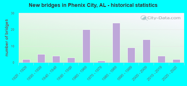
- New bridges - historical statistics
- 21920-1929
- 51930-1939
- 41940-1949
- 31950-1959
- 201960-1969
- 11970-1979
- 241980-1989
- 91990-1999
- 142000-2009
- 42010-2019
- 22020-2022
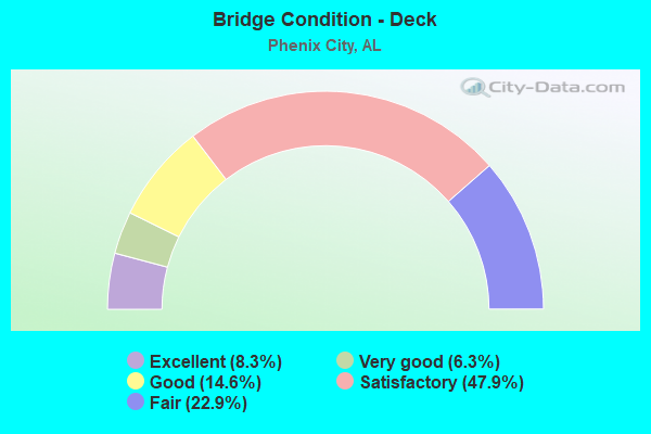
- Bridge Condition - Deck
- 8.3%Excellent
- 6.3%Very good
- 14.6%Good
- 47.9%Satisfactory
- 22.9%Fair

- Bridge Condition - Superstructure
- 8.3%Excellent
- 12.5%Very good
- 31.3%Good
- 35.4%Satisfactory
- 12.5%Fair

- Bridge Condition - Substructure
- 8.3%Excellent
- 12.5%Very good
- 37.5%Good
- 29.2%Satisfactory
- 10.4%Fair
- 2.1%Poor
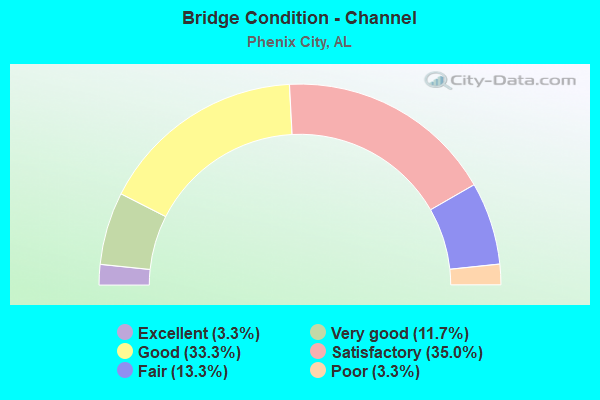
- Bridge Condition - Channel
- 3.3%Excellent
- 11.7%Very good
- 33.3%Good
- 35.0%Satisfactory
- 13.3%Fair
- 3.3%Poor
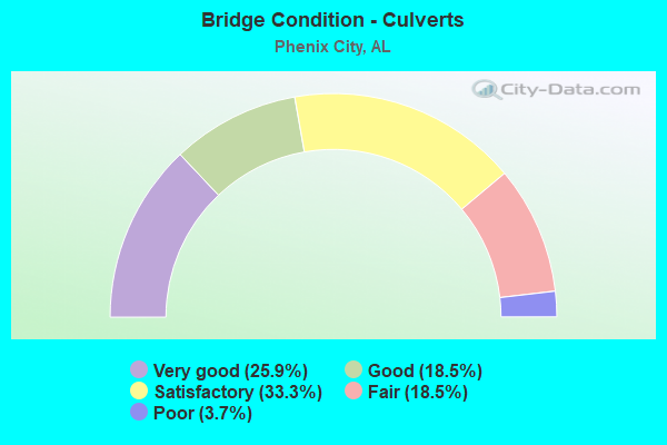
- Bridge Condition - Culverts
- 25.9%Very good
- 18.5%Good
- 33.3%Satisfactory
- 18.5%Fair
- 3.7%Poor
Find on map >> Show street view
Structure Number: 228, Location: .4 MI. SO. ASHVILLE CL (Lat: 33.805000, Lng: -86.303889), Route carried "on" structure: US 23, Year Built: 1924, Status: Open, Structure Length: 3.23m (10.60ft), Average Daily Traffic: 910 (year 2021), Truck Traffic: 3%, Average Future Daily Traffic: 1,104 (year 2041), Design Load: H 15, Features Intersected: DRY BRANCH
Minimum Vertical Clearance: 30+ m (98+ ft), Kilometerpoint: 14.782, Lanes on structure: 2, Owner: State Highway Agency, Approaching Roadway Width: 6.1m (20.0ft), Material/Design: Concrete, Design/Construction: Tee Beam, Number Of Spans In Main Unit: 4, Length of Maximum Span: 7.9m (25.9ft), Curb-To-Curb Width: 5.5m (18.0ft), Out-to-Out Width: 6.0m (19.7ft)
Condition: Deck: Satisfactory, Superstructure: Satisfactory, Substructure: Satisfactory, Channel: Satisfactory, Operating Rating: 57.6 metric tons, Method Used To Determine Operating Rating: Load Factor (LF), Inventory Rating: 34.6 metric tons, Method Used To Determine Inventory Rating: Load Factor (LF), Structural Evaluation: Equal to present minimum criteria, Deck Geometry: High priority of replacement, Waterway Adequacy: Better than present minimum criteria, Approach Roadway Alignment: Somewhat better than minimum adequacy, Length Of Structure Improvement: 4.10m (13.45ft), Designated Inspection Frequency: Every 24 months, Inspection Date: June 2021, Bridge Improvement Cost: $534,000, Roadway Improvement Cost: $53,000, Total Project Cost: $587,000 ( Estimate for 2022), Deck Structure Type: Concrete Cast-file-Place, Wearing Surface/Protective System: Wearing Surface: Bituminous
Find on map >> Show street view
Structure Number: 26, Location: 4.2 MI N JCT SR 169 (Lat: 32.355081, Lng: -85.095244), Route carried "on" structure: County highway 137, Year Built: 1925, Status: Posted for load, Structure Length: 10.00m (32.81ft), Average Daily Traffic: 357 (year 2000), Truck Traffic: 12%, Average Future Daily Traffic: 390 (year 2032), Design Load: H 15, Features Intersected: UCHEE CREEK
Minimum Vertical Clearance: 30+ m (98+ ft), Kilometerpoint: 0.000, Lanes on structure: 2, Owner: County Highway Agency, Approaching Roadway Width: 7.3m (24.0ft), Material/Design: Steel continuous, Design/Construction: Stringer/Multi-beam, Number Of Spans In Main Unit: 1, Number Of Approach Spans: 9, Length of Maximum Span: 16.2m (53.1ft), Curb or Sidewalk Widths: Left: 0.5m (1.6ft), Right: 0.5m (1.6ft), Curb-To-Curb Width: 7.9m (25.9ft), Out-to-Out Width: 8.8m (28.9ft)
Condition: Deck: Fair, Superstructure: Fair, Substructure: Poor, Channel: Satisfactory, Operating Rating: 30.0 metric tons, Method Used To Determine Operating Rating: Load Factor (LF), Inventory Rating: 18.0 metric tons, Method Used To Determine Inventory Rating: Load Factor (LF), Structural Evaluation: Meets minimum limits, Deck Geometry: Somewhat better than minimum adequacy, Waterway Adequacy: Equal to present minimum criteria, Approach Roadway Alignment: Somewhat better than minimum adequacy, Bridge Posting: Required (Relationship of Operating Rating to Maximum Legal Load: 20.0 - 29.9% below), Length Of Structure Improvement: 10.93m (35.86ft), Designated Inspection Frequency: Every 24 months, Other Special Inspection Frequency: Every 12 months, Inspection Date: August 2020, Other Special Inspection Date: August 2021, Bridge Improvement Cost: $2,099,000, Roadway Improvement Cost: $210,000, Total Project Cost: $2,309,000 ( Estimate for 2022), Deck Structure Type: Concrete Cast-file-Place
Find on map >> Show street view
Structure Number: 1359, Location: 0.2 MI E CO RD 416 (Lat: 34.797758, Lng: -86.375472), Route carried "on" structure: County highway 415, Year Built: 1935, Status: Posted for load, Structure Length: 1.34m (4.40ft), Average Daily Traffic: 80 (year 1992), Average Future Daily Traffic: 125 (year 2040), Design Load: H 15, Features Intersected: MOLDER BRANCH, Facility Carried by Structure: BOB STILES RD
Minimum Vertical Clearance: 30+ m (98+ ft), Kilometerpoint: 0.010, Lanes on structure: 2, Owner: County Highway Agency, Approaching Roadway Width: 7.3m (24.0ft), Material/Design: Steel, Design/Construction: Stringer/Multi-beam, Number Of Spans In Main Unit: 2, Length of Maximum Span: 6.7m (22.0ft), Curb-To-Curb Width: 7.3m (24.0ft), Out-to-Out Width: 7.8m (25.6ft)
Condition: Deck: Fair, Superstructure: Fair, Substructure: Fair, Channel: Fair, Operating Rating: 12.6 metric tons, Method Used To Determine Operating Rating: Allowable Stress (AS), Inventory Rating: 5.9 metric tons, Method Used To Determine Inventory Rating: Allowable Stress (AS), Structural Evaluation: High priority of replacement, Deck Geometry: Equal to present minimum criteria, Waterway Adequacy: Equal to present minimum criteria, Approach Roadway Alignment: Somewhat better than minimum adequacy, Bridge Posting: Required (Relationship of Operating Rating to Maximum Legal Load: > 39.9% below), Length Of Structure Improvement: 2.02m (6.63ft), Designated Inspection Frequency: Every 24 months, Other Special Inspection Frequency: Every 12 months, Inspection Date: September 2020, Other Special Inspection Date: September 2021, Bridge Improvement Cost: $346,000, Roadway Improvement Cost: $35,000, Total Project Cost: $381,000 ( Estimate for 2022), Deck Structure Type: Concrete Cast-file-Place
Find on map >> Show street view
Structure Number: 181, Location: 5.8 MI S CR 93 (Lat: 34.899283, Lng: -85.711503), Route carried "on" structure: County highway 91, Year Built: 1938, Status: Posted for load, Structure Length: 7.53m (24.70ft), Average Daily Traffic: 95 (year 1990), Average Future Daily Traffic: 130 (year 2038), Design Load: H 10, Features Intersected: LONG ISLAND CREEK
Minimum Vertical Clearance: 30+ m (98+ ft), Kilometerpoint: 0.010, Lanes on structure: 1, Owner: County Highway Agency, Approaching Roadway Width: 7.3m (24.0ft), Material/Design: Steel, Design/Construction: Stringer/Multi-beam, Number Of Spans In Main Unit: 1, Number Of Approach Spans: 4, Length of Maximum Span: 26.2m (86.0ft), Curb or Sidewalk Widths: Left: 0.3m (1.0ft), Right: 0.3m (1.0ft), Curb-To-Curb Width: 5.3m (17.4ft), Out-to-Out Width: 6.6m (21.7ft)
Condition: Deck: Fair, Superstructure: Fair, Substructure: Satisfactory, Channel: Satisfactory, Operating Rating: 16.1 metric tons, Method Used To Determine Operating Rating: Load Factor (LF), Inventory Rating: 9.0 metric tons, Method Used To Determine Inventory Rating: Load Factor (LF), Structural Evaluation: High priority of replacement, Deck Geometry: High priority of corrective action, Waterway Adequacy: Superior to present desirable criteria, Approach Roadway Alignment: Somewhat better than minimum adequacy, Bridge Posting: Required (Relationship of Operating Rating to Maximum Legal Load: > 39.9% below), Length Of Structure Improvement: 8.55m (28.05ft), Designated Inspection Frequency: Every 24 months, Underwater Inspection Frequency: Every 48 months, Other Special Inspection Frequency: Every 12 months, Inspection Date: November 2020, Underwater Inspection Date: May 2018, Other Special Inspection Date: November 2021, Bridge Improvement Cost: $1,231,000, Roadway Improvement Cost: $123,000, Total Project Cost: $1,354,000 ( Estimate for 2022), Deck Structure Type: Concrete Precast Panels
Find on map >> Show street view
Structure Number: 1864, Location: 0.25 MI NE US HWY 72 E (Lat: 34.749217, Lng: -86.444642), Route carried "on" structure: County highway 306, Year Built: 1938, Status: Open, Structure Length: 3.57m (11.71ft), Average Daily Traffic: 450 (year 1992), Truck Traffic: 1%, Average Future Daily Traffic: 780 (year 2035), Design Load: H 15, Features Intersected: FLINT RIVER (RELIEF), Facility Carried by Structure: BROWNSBORO RD
Minimum Vertical Clearance: 30+ m (98+ ft), Kilometerpoint: 0.010, Lanes on structure: 2, Owner: County Highway Agency, Approaching Roadway Width: 7.3m (24.0ft), Material/Design: Concrete, Design/Construction: Slab, Number Of Spans In Main Unit: 8, Length of Maximum Span: 5.2m (17.1ft), Curb-To-Curb Width: 5.8m (19.0ft), Out-to-Out Width: 6.2m (20.3ft)
Condition: Deck: Satisfactory, Superstructure: Satisfactory, Substructure: Satisfactory, Channel: Poor, Operating Rating: 43.5 metric tons, Method Used To Determine Operating Rating: Field evaluation and documented engineering judgment, Inventory Rating: 32.7 metric tons, Method Used To Determine Inventory Rating: Field evaluation and documented engineering judgment, Structural Evaluation: Equal to present minimum criteria, Deck Geometry: High priority of replacement, Waterway Adequacy: Meets minimum limits, Approach Roadway Alignment: Equal to present minimum criteria, Length Of Structure Improvement: 4.48m (14.70ft), Designated Inspection Frequency: Every 24 months, Inspection Date: June 2020, Bridge Improvement Cost: $614,000, Roadway Improvement Cost: $61,000, Total Project Cost: $675,000 ( Estimate for 2022), Deck Structure Type: Concrete Cast-file-Place, Wearing Surface/Protective System: Wearing Surface: Bituminous
Find on map >> Show street view
Structure Number: 1899, Location: 4.1 MI N JCT SR 169 (Lat: 32.353339, Lng: -85.095658), Route carried "on" structure: County highway 137, Year Built: 1939, Status: Open, Structure Length: 4.08m (13.39ft), Average Daily Traffic: 6,960 (year 1994), Truck Traffic: 12%, Average Future Daily Traffic: 7,050 (year 2034), Design Load: H 15, Features Intersected: UCHEE CREEK RELIEF
Minimum Vertical Clearance: 30+ m (98+ ft), Kilometerpoint: 0.000, Lanes on structure: 2, Owner: County Highway Agency, Approaching Roadway Width: 7.3m (24.0ft), Skew: 9 degrees, Material/Design: Steel, Design/Construction: Stringer/Multi-beam, Number Of Spans In Main Unit: 6, Length of Maximum Span: 6.7m (22.0ft), Curb or Sidewalk Widths: Left: 0.5m (1.6ft), Right: 0.5m (1.6ft), Curb-To-Curb Width: 7.9m (25.9ft), Out-to-Out Width: 8.8m (28.9ft)
Condition: Deck: Satisfactory, Superstructure: Fair, Substructure: Satisfactory, Channel: Excellent, Operating Rating: 61.2 metric tons, Method Used To Determine Operating Rating: Allowable Stress (AS), Inventory Rating: 40.8 metric tons, Method Used To Determine Inventory Rating: Allowable Stress (AS), Structural Evaluation: Somewhat better than minimum adequacy, Deck Geometry: High priority of replacement, Waterway Adequacy: Equal to present desirable criteria, Approach Roadway Alignment: Somewhat better than minimum adequacy, Length Of Structure Improvement: 5.04m (16.54ft), Designated Inspection Frequency: Every 24 months, Inspection Date: May 2020, Bridge Improvement Cost: $968,000, Roadway Improvement Cost: $97,000, Total Project Cost: $1,065,000 ( Estimate for 2022), Deck Structure Type: Concrete Cast-file-Place
Find on map >> Show street view
Structure Number: 2084, Location: 2 MI N HWY 53 (Lat: 34.932806, Lng: -86.748358), Route carried "on" structure: County highway 495, Year Built: 1939, Status: Open, Structure Length: 0.85m (2.79ft), Average Daily Traffic: 699 (year 1987), Truck Traffic: 1%, Average Future Daily Traffic: 980 (year 2034), Design Load: H 15, Features Intersected: DRY CREEK, Facility Carried by Structure: WALL-TRIANA HWY
Minimum Vertical Clearance: 30+ m (98+ ft), Kilometerpoint: 0.010, Lanes on structure: 2, Owner: County Highway Agency, Approaching Roadway Width: 7.9m (25.9ft), Material/Design: Masonry, Design/Construction: Culvert, Number Of Spans In Main Unit: 2, Length of Maximum Span: 3.7m (12.1ft), Curb-To-Curb Width: 6.2m (20.3ft), Out-to-Out Width: 6.7m (22.0ft)
Condition: Channel: Satisfactory, Culverts: Satisfactory, Operating Rating: 32.7 metric tons, Method Used To Determine Operating Rating: Field evaluation and documented engineering judgment, Inventory Rating: 23.6 metric tons, Method Used To Determine Inventory Rating: Field evaluation and documented engineering judgment, Structural Evaluation: Equal to present minimum criteria, Deck Geometry: High priority of corrective action, Waterway Adequacy: Somewhat better than minimum adequacy, Approach Roadway Alignment: Equal to present minimum criteria, Length Of Structure Improvement: 1.51m (4.95ft), Designated Inspection Frequency: Every 24 months, Inspection Date: April 2020, Bridge Improvement Cost: $192,000, Roadway Improvement Cost: $19,000, Total Project Cost: $211,000 ( Estimate for 2022)
Find on map >> Show street view
Structure Number: 2233, Location: 3.8 MI S JCT SR 165 (Lat: 32.376931, Lng: -85.083169), Route carried "on" structure: County highway 137, Year Built: 1940, Status: Open, Structure Length: 2.07m (6.79ft), Average Daily Traffic: 7,690 (year 1994), Truck Traffic: 12%, Average Future Daily Traffic: 15,301 (year 2034), Design Load: H 15, Features Intersected: LITTLE UCHEE CK. RELIEF
Minimum Vertical Clearance: 30+ m (98+ ft), Kilometerpoint: 0.000, Lanes on structure: 2, Owner: County Highway Agency, Approaching Roadway Width: 7.3m (24.0ft), Material/Design: Steel, Design/Construction: Stringer/Multi-beam, Number Of Spans In Main Unit: 3, Length of Maximum Span: 6.7m (22.0ft), Curb or Sidewalk Widths: Left: 0.5m (1.6ft), Right: 0.5m (1.6ft), Curb-To-Curb Width: 7.3m (24.0ft), Out-to-Out Width: 8.2m (26.9ft)
Condition: Deck: Satisfactory, Superstructure: Fair, Substructure: Fair, Channel: Very good, Operating Rating: 53.6 metric tons, Method Used To Determine Operating Rating: Load Factor (LF), Inventory Rating: 32.1 metric tons, Method Used To Determine Inventory Rating: Load Factor (LF), Structural Evaluation: Somewhat better than minimum adequacy, Deck Geometry: High priority of replacement, Waterway Adequacy: Equal to present minimum criteria, Approach Roadway Alignment: Equal to present minimum criteria, Length Of Structure Improvement: 2.84m (9.32ft), Designated Inspection Frequency: Every 24 months, Inspection Date: May 2020, Bridge Improvement Cost: $506,000, Roadway Improvement Cost: $51,000, Total Project Cost: $557,000 ( Estimate for 2022), Deck Structure Type: Concrete Cast-file-Place
Find on map >> Show street view
Structure Number: 2238, Location: PHENIX CITY (Lat: 32.466667, Lng: -85.016667), Route carried "on" structure: City street , Year Built: 1940, Status: Open, Structure Length: 1.04m (3.41ft), Average Daily Traffic: 1,500 (year 2020), Truck Traffic: 1%, Average Future Daily Traffic: 1,800 (year 2040), Design Load: HS 20, Features Intersected: HOLLAND CREEK, Facility Carried by Structure: BRIDGEWATER DRIVE
Minimum Vertical Clearance: 30+ m (98+ ft), Kilometerpoint: 0.299, Lanes on structure: 2, Owner: City or Municipal Highway Agency, Approaching Roadway Width: 9.6m (31.5ft), Material/Design: Concrete, Design/Construction: Channel Beam, Number Of Spans In Main Unit: 1, Length of Maximum Span: 10.4m (34.1ft), Curb or Sidewalk Widths: Left: 0.3m (1.0ft), Right: 0.3m (1.0ft), Curb-To-Curb Width: 9.6m (31.5ft), Out-to-Out Width: 10.2m (33.5ft)
Condition: Deck: Satisfactory, Superstructure: Good, Substructure: Fair, Channel: Satisfactory, Operating Rating: 49.8 metric tons, Method Used To Determine Operating Rating: Load Factor (LF), Inventory Rating: 29.8 metric tons, Method Used To Determine Inventory Rating: Load Factor (LF), Structural Evaluation: Somewhat better than minimum adequacy, Deck Geometry: Somewhat better than minimum adequacy, Waterway Adequacy: Better than present minimum criteria, Approach Roadway Alignment: Equal to present minimum criteria, Length Of Structure Improvement: 1.71m (5.61ft), Designated Inspection Frequency: Every 24 months, Inspection Date: April 2020, Bridge Improvement Cost: $386,000, Roadway Improvement Cost: $39,000, Total Project Cost: $425,000 ( Estimate for 2022), Deck Structure Type: Concrete Precast Panels, Wearing Surface/Protective System: Wearing Surface: Bituminous
Find on map >> Show street view
Structure Number: 228, Location: 1 MI EAST LEE CO LINE (Lat: 32.439917, Lng: -85.314972), Route carried "on" structure: US 80, Year Built: 1940, Status: Open, Structure Length: 2.74m (8.99ft), Average Daily Traffic: 3,170 (year 2013), Truck Traffic: 15%, Average Future Daily Traffic: 4,145 (year 2033), Design Load: H 15, Features Intersected: SNAKE CREEK
Minimum Vertical Clearance: 30+ m (98+ ft), Kilometerpoint: 317.752, Lanes on structure: 2, Base Highway Network: Yes, Owner: State Highway Agency, Approaching Roadway Width: 7.3m (24.0ft), Material/Design: Steel, Design/Construction: Stringer/Multi-beam, Number Of Spans In Main Unit: 4, Length of Maximum Span: 6.7m (22.0ft), Curb or Sidewalk Widths: Left: 0.5m (1.6ft), Right: 0.5m (1.6ft), Curb-To-Curb Width: 7.2m (23.6ft), Out-to-Out Width: 8.7m (28.5ft)
Condition: Deck: Fair, Superstructure: Satisfactory, Substructure: Satisfactory, Channel: Satisfactory, Operating Rating: 57.7 metric tons, Method Used To Determine Operating Rating: Load Factor (LF), Inventory Rating: 34.6 metric tons, Method Used To Determine Inventory Rating: Load Factor (LF), Structural Evaluation: Equal to present minimum criteria, Deck Geometry: High priority of replacement, Waterway Adequacy: Equal to present minimum criteria, Approach Roadway Alignment: Better than present minimum criteria, Length Of Structure Improvement: 3.66m (12.01ft), Designated Inspection Frequency: Every 24 months, Inspection Date: January 2022, Bridge Improvement Cost: $703,000, Roadway Improvement Cost: $70,000, Total Project Cost: $773,000 ( Estimate for 2022), Deck Structure Type: Concrete Cast-file-Place
Find on map >> Show street view
Structure Number: 2281, Location: 2.6 MI EAST LEE CO LINE (Lat: 32.443778, Lng: -85.288028), Route carried "on" structure: State highway 80, Year Built: 1940, Status: Open, Structure Length: 4.75m (15.58ft), Average Daily Traffic: 4,520 (year 2013), Truck Traffic: 16%, Average Future Daily Traffic: 5,910 (year 2033), Design Load: H 15, Features Intersected: BRUSH CREEK
Minimum Vertical Clearance: 30+ m (98+ ft), Kilometerpoint: 320.279, Lanes on structure: 2, Base Highway Network: Yes, Owner: State Highway Agency, Approaching Roadway Width: 7.3m (24.0ft), Material/Design: Steel, Design/Construction: Stringer/Multi-beam, Number Of Spans In Main Unit: 7, Length of Maximum Span: 6.7m (22.0ft), Curb or Sidewalk Widths: Left: 0.5m (1.6ft), Right: 0.5m (1.6ft), Curb-To-Curb Width: 7.2m (23.6ft), Out-to-Out Width: 9.0m (29.5ft)
Condition: Deck: Fair, Superstructure: Fair, Substructure: Fair, Channel: Good, Operating Rating: 53.4 metric tons, Method Used To Determine Operating Rating: Load Testing, Inventory Rating: 38.9 metric tons, Method Used To Determine Inventory Rating: Load Testing, Structural Evaluation: Somewhat better than minimum adequacy, Deck Geometry: High priority of replacement, Waterway Adequacy: Equal to present minimum criteria, Approach Roadway Alignment: Equal to present desirable criteria, Length Of Structure Improvement: 5.75m (18.86ft), Designated Inspection Frequency: Every 24 months, Inspection Date: March 2021, Bridge Improvement Cost: $1,144,000, Roadway Improvement Cost: $114,000, Total Project Cost: $1,258,000 ( Estimate for 2022), Deck Structure Type: Concrete Cast-file-Place
Find on map >> Show street view
Structure Number: 3696, Location: 2.5 MI SW US 280 (US 431) (Lat: 32.425244, Lng: -84.995994), Route carried "on" structure: City street , Year Built: 1950, Status: Posted for load, Structure Length: 4.57m (14.99ft), Average Daily Traffic: 1,500 (year 2021), Truck Traffic: 30%, Average Future Daily Traffic: 3,000 (year 2041), Design Load: H 20, Features Intersected: COCHGALECHEE CREEK, Facility Carried by Structure: BRICKYARD RD(CO 61
Minimum Vertical Clearance: 30+ m (98+ ft), Kilometerpoint: 2.499, Lanes on structure: 2, Owner: City or Municipal Highway Agency, Approaching Roadway Width: 7.9m (25.9ft), Material/Design: Concrete, Design/Construction: Tee Beam, Number Of Spans In Main Unit: 5, Length of Maximum Span: 9.1m (29.9ft), Curb or Sidewalk Widths: Left: 0.5m (1.6ft), Right: 0.5m (1.6ft), Curb-To-Curb Width: 7.8m (25.6ft), Out-to-Out Width: 9.1m (29.9ft)
Condition: Deck: Satisfactory, Superstructure: Satisfactory, Substructure: Satisfactory, Channel: Fair, Operating Rating: 26.2 metric tons, Method Used To Determine Operating Rating: Load Factor (LF), Inventory Rating: 15.7 metric tons, Method Used To Determine Inventory Rating: Load Factor (LF), Structural Evaluation: Meets minimum limits, Deck Geometry: Meets minimum limits, Waterway Adequacy: Better than present minimum criteria, Approach Roadway Alignment: Equal to present desirable criteria, Bridge Posting: Required (Relationship of Operating Rating to Maximum Legal Load: 20.0 - 29.9% below), Length Of Structure Improvement: 5.57m (18.27ft), Designated Inspection Frequency: Every 24 months, Other Special Inspection Frequency: Every 12 months, Inspection Date: April 2020, Other Special Inspection Date: May 2021, Bridge Improvement Cost: $1,107,000, Roadway Improvement Cost: $111,000, Total Project Cost: $1,218,000 ( Estimate for 2022), Deck Structure Type: Concrete Cast-file-Place
Find on map >> Show street view
Structure Number: 4291, Location: PHENIX CITY (Lat: 32.435000, Lng: -85.011667), Route carried "on" structure: City street , Year Built: 1952, Status: Open, Structure Length: 2.06m (6.76ft), Average Daily Traffic: 5,150 (year 2020), Truck Traffic: 1%, Average Future Daily Traffic: 10,300 (year 2040), Design Load: H 15, Features Intersected: COCHGALECHEE CREEK, Facility Carried by Structure: SEALE ROAD
Minimum Vertical Clearance: 30+ m (98+ ft), Kilometerpoint: 0.999, Lanes on structure: 2, Owner: City or Municipal Highway Agency, Approaching Roadway Width: 7.0m (23.0ft), Material/Design: Concrete, Design/Construction: Tee Beam, Number Of Spans In Main Unit: 2, Length of Maximum Span: 10.3m (33.8ft), Curb or Sidewalk Widths: Left: 0.1m (0.3ft), Right: 0.1m (0.3ft), Curb-To-Curb Width: 7.3m (24.0ft), Out-to-Out Width: 8.0m (26.2ft)
Condition: Deck: Satisfactory, Superstructure: Good, Substructure: Satisfactory, Channel: Satisfactory, Operating Rating: 32.7 metric tons, Method Used To Determine Operating Rating: Field evaluation and documented engineering judgment, Inventory Rating: 23.6 metric tons, Method Used To Determine Inventory Rating: Field evaluation and documented engineering judgment, Structural Evaluation: Somewhat better than minimum adequacy, Deck Geometry: High priority of replacement, Waterway Adequacy: Equal to present minimum criteria, Approach Roadway Alignment: Better than present minimum criteria, Length Of Structure Improvement: 2.83m (9.28ft), Designated Inspection Frequency: Every 24 months, Inspection Date: April 2020, Bridge Improvement Cost: $505,000, Roadway Improvement Cost: $51,000, Total Project Cost: $556,000 ( Estimate for 2022), Deck Structure Type: Concrete Cast-file-Place, Wearing Surface/Protective System: Wearing Surface: Bituminous
Find on map >> Show street view
Structure Number: 5198, Location: LATO (Lat: 32.322586, Lng: -85.096072), Route carried "on" structure: County highway 24, Year Built: 1955, Status: Open, Structure Length: 1.31m (4.30ft), Average Daily Traffic: 240 (year 1980), Truck Traffic: 2%, Average Future Daily Traffic: 300 (year 2034), Features Intersected: COWPEN CREEK
Minimum Vertical Clearance: 30+ m (98+ ft), Kilometerpoint: 0.010, Lanes on structure: 2, Owner: County Highway Agency, Approaching Roadway Width: 7.3m (24.0ft), Material/Design: Concrete, Design/Construction: Culvert, Number Of Spans In Main Unit: 3, Length of Maximum Span: 3.7m (12.1ft), Curb-To-Curb Width: 14.6m (47.9ft), Out-to-Out Width: 15.2m (49.9ft)
Condition: Channel: Satisfactory, Culverts: Fair, Operating Rating: 44.3 metric tons, Method Used To Determine Operating Rating: Load Factor (LF), Inventory Rating: 26.6 metric tons, Method Used To Determine Inventory Rating: Load Factor (LF), Structural Evaluation: Somewhat better than minimum adequacy, Deck Geometry: Superior to present desirable criteria, Waterway Adequacy: Better than present minimum criteria, Approach Roadway Alignment: Equal to present minimum criteria, Length Of Structure Improvement: 1.98m (6.50ft), Designated Inspection Frequency: Every 24 months, Inspection Date: May 2020, Bridge Improvement Cost: $344,000, Roadway Improvement Cost: $34,000, Total Project Cost: $378,000 ( Estimate for 2022), Deck Structure Type: Concrete Cast-file-Place, Wearing Surface/Protective System: Wearing Surface: Bituminous
Find on map >> Show street view
Structure Number: 7022, Location: 10 MI S W PHENIX CITY (Lat: 32.342439, Lng: -85.053956), Route carried "on" structure: County highway 39, Year Built: 1960, Status: Posted for load, Structure Length: 14.23m (46.69ft), Average Daily Traffic: 750 (year 1991), Truck Traffic: 10%, Average Future Daily Traffic: 1,000 (year 2035), Design Load: H 15, Features Intersected: UCHEE CREEK
Minimum Vertical Clearance: 30+ m (98+ ft), Kilometerpoint: 0.010, Lanes on structure: 2, Owner: County Highway Agency, Approaching Roadway Width: 7.9m (25.9ft), Material/Design: Concrete continuous, Design/Construction: Tee Beam, Number Of Spans In Main Unit: 3, Number Of Approach Spans: 9, Length of Maximum Span: 18.3m (60.0ft), Curb-To-Curb Width: 6.2m (20.3ft), Out-to-Out Width: 6.7m (22.0ft)
Condition: Deck: Satisfactory, Superstructure: Satisfactory, Substructure: Satisfactory, Channel: Satisfactory, Operating Rating: 29.9 metric tons, Method Used To Determine Operating Rating: Load Factor (LF), Inventory Rating: 17.8 metric tons, Method Used To Determine Inventory Rating: Load Factor (LF), Structural Evaluation: Meets minimum limits, Deck Geometry: High priority of corrective action, Waterway Adequacy: Superior to present desirable criteria, Approach Roadway Alignment: Somewhat better than minimum adequacy, Bridge Posting: Required (Relationship of Operating Rating to Maximum Legal Load: 20.0 - 29.9% below), Length Of Structure Improvement: 15.02m (49.28ft), Designated Inspection Frequency: Every 24 months, Other Special Inspection Frequency: Every 12 months, Inspection Date: August 2020, Other Special Inspection Date: August 2021, Bridge Improvement Cost: $2,266,000, Roadway Improvement Cost: $227,000, Total Project Cost: $2,493,000 ( Estimate for 2022), Deck Structure Type: Concrete Cast-file-Place
Find on map >> Show street view
Structure Number: 7023, Location: 10.5 MI S W PHENIX CITY (Lat: 32.333211, Lng: -85.055564), Route carried "on" structure: County highway 39, Year Built: 1960, Status: Open, Structure Length: 1.52m (4.99ft), Average Daily Traffic: 750 (year 1981), Truck Traffic: 10%, Average Future Daily Traffic: 1,000 (year 2031), Features Intersected: COWPEN CREEK
Minimum Vertical Clearance: 30+ m (98+ ft), Kilometerpoint: 0.010, Lanes on structure: 2, Owner: County Highway Agency, Approaching Roadway Width: 7.9m (25.9ft), Material/Design: Concrete, Design/Construction: Culvert, Number Of Spans In Main Unit: 4, Length of Maximum Span: 3.7m (12.1ft), Curb-To-Curb Width: 10.4m (34.1ft), Out-to-Out Width: 11.0m (36.1ft)
Condition: Channel: Satisfactory, Culverts: Fair, Operating Rating: 88.9 metric tons, Method Used To Determine Operating Rating: Load Factor (LF), Inventory Rating: 51.7 metric tons, Method Used To Determine Inventory Rating: Load Factor (LF), Structural Evaluation: Somewhat better than minimum adequacy, Deck Geometry: Equal to present minimum criteria, Waterway Adequacy: Equal to present desirable criteria, Approach Roadway Alignment: Better than present minimum criteria, Length Of Structure Improvement: 2.20m (7.22ft), Designated Inspection Frequency: Every 24 months, Inspection Date: June 2020, Bridge Improvement Cost: $610,000, Roadway Improvement Cost: $61,000, Total Project Cost: $671,000 ( Estimate for 2022), Wearing Surface/Protective System: Wearing Surface: Bituminous
Find on map >> Show street view
Structure Number: 735, Location: 1.0 MI E. JCT. US 80-280 (Lat: 32.473333, Lng: -85.018333), Route carried "on" structure: City street , Year Built: 1961, Status: Open, Structure Length: 2.21m (7.25ft), Average Daily Traffic: 22,000 (year 2020), Truck Traffic: 15%, Average Future Daily Traffic: 34,000 (year 2040), Design Load: HS 20, Features Intersected: HOLLAND CREEK, Facility Carried by Structure: CRAWFORD RD.14THST
Minimum Vertical Clearance: 30+ m (98+ ft), Kilometerpoint: 2.200, Lanes on structure: 4, Owner: City or Municipal Highway Agency, Approaching Roadway Width: 21.9m (71.9ft), Skew: 23 degrees, Material/Design: Concrete, Design/Construction: Culvert, Number Of Spans In Main Unit: 5, Length of Maximum Span: 3.7m (12.1ft), Curb or Sidewalk Widths: Left: 1.5m (4.9ft), Right: 1.5m (4.9ft), Curb-To-Curb Width: 21.9m (71.9ft), Out-to-Out Width: 27.2m (89.2ft)
Condition: Channel: Fair, Culverts: Fair, Operating Rating: 39.2 metric tons, Method Used To Determine Operating Rating: Load Factor (LF), Inventory Rating: 23.5 metric tons, Method Used To Determine Inventory Rating: Load Factor (LF), Structural Evaluation: Somewhat better than minimum adequacy, Deck Geometry: Superior to present desirable criteria, Waterway Adequacy: Better than present minimum criteria, Approach Roadway Alignment: Equal to present desirable criteria, Length Of Structure Improvement: 3.01m (9.88ft), Designated Inspection Frequency: Every 24 months, Inspection Date: April 2020, Bridge Improvement Cost: $1,790,000, Roadway Improvement Cost: $179,000, Total Project Cost: $1,969,000 ( Estimate for 2022)
Find on map >> Show street view
Structure Number: 7351, Location: 0.6 MI E JCT US 80-280 (Lat: 32.475000, Lng: -85.025000), Route carried "on" structure: City street , Year Built: 1961, Status: Open, Structure Length: 0.88m (2.89ft), Average Daily Traffic: 22,000 (year 2020), Truck Traffic: 15%, Average Future Daily Traffic: 34,000 (year 2040), Design Load: H 20, Features Intersected: TRIB HOLLAND CREEK, Facility Carried by Structure: CRAWFORD RD.
Minimum Vertical Clearance: 30+ m (98+ ft), Kilometerpoint: 2.499, Lanes on structure: 4, Owner: City or Municipal Highway Agency, Approaching Roadway Width: 22.0m (72.2ft), Skew: 24 degrees, Material/Design: Concrete, Design/Construction: Culvert, Number Of Spans In Main Unit: 2, Length of Maximum Span: 3.0m (9.8ft), Curb-To-Curb Width: 22.0m (72.2ft), Out-to-Out Width: 27.4m (89.9ft)
Condition: Channel: Fair, Culverts: Fair, Operating Rating: 88.9 metric tons, Method Used To Determine Operating Rating: Load Factor (LF), Inventory Rating: 69.3 metric tons, Method Used To Determine Inventory Rating: Load Factor (LF), Structural Evaluation: Somewhat better than minimum adequacy, Deck Geometry: Superior to present desirable criteria, Waterway Adequacy: Superior to present desirable criteria, Approach Roadway Alignment: Equal to present desirable criteria, Length Of Structure Improvement: 1.55m (5.09ft), Designated Inspection Frequency: Every 24 months, Inspection Date: April 2020, Bridge Improvement Cost: $1,138,000, Roadway Improvement Cost: $114,000, Total Project Cost: $1,252,000 ( Estimate for 2022)
Find on map >> Show street view
Structure Number: 7699, Location: 7.8 MI W PHENIX CITY (Lat: 32.409372, Lng: -85.100525), Route carried "on" structure: County highway 28, Year Built: 1962, Status: Posted for load, Structure Length: 4.15m (13.62ft), Average Daily Traffic: 900 (year 1981), Truck Traffic: 5%, Average Future Daily Traffic: 1,000 (year 2030), Design Load: H 15, Features Intersected: BUSH POND BRANCH
Minimum Vertical Clearance: 30+ m (98+ ft), Kilometerpoint: 0.010, Lanes on structure: 2, Owner: County Highway Agency, Approaching Roadway Width: 7.9m (25.9ft), Material/Design: Concrete, Design/Construction: Tee Beam, Number Of Spans In Main Unit: 4, Length of Maximum Span: 10.4m (34.1ft), Curb-To-Curb Width: 6.7m (22.0ft), Out-to-Out Width: 7.1m (23.3ft)
Condition: Deck: Fair, Superstructure: Satisfactory, Substructure: Satisfactory, Channel: Satisfactory, Operating Rating: 35.7 metric tons, Method Used To Determine Operating Rating: Load Factor (LF), Inventory Rating: 21.4 metric tons, Method Used To Determine Inventory Rating: Load Factor (LF), Structural Evaluation: Somewhat better than minimum adequacy, Deck Geometry: Meets minimum limits, Waterway Adequacy: Equal to present desirable criteria, Approach Roadway Alignment: Better than present minimum criteria, Bridge Posting: Required (Relationship of Operating Rating to Maximum Legal Load: 0.1 - 9.9% below), Length Of Structure Improvement: 5.12m (16.80ft), Designated Inspection Frequency: Every 24 months, Other Special Inspection Frequency: Every 12 months, Inspection Date: September 2021, Other Special Inspection Date: September 2021, Bridge Improvement Cost: $807,000, Roadway Improvement Cost: $81,000, Total Project Cost: $888,000 ( Estimate for 2022), Deck Structure Type: Concrete Cast-file-Place
Find on map >> Show street view
Structure Number: 7904, Location: MI 115.9-1.33 MI E US 80 (Lat: 31.456611, Lng: -85.012722), Route carried "on" structure: County highway 28, Year Built: 1963, Status: Open, Structure Length: 8.63m (28.31ft), Average Daily Traffic: 4,710 (year 2009), Truck Traffic: 2%, Average Future Daily Traffic: 6,594 (year 2033), Design Load: H 20, Features Intersected: US 431, Facility Carried by Structure: SANFORT RD.
Minimum Vertical Clearance: 30+ m (98+ ft), Kilometerpoint: 0.000, Lanes on structure: 2, Lanes under structure: 6, Owner: State Highway Agency, Approaching Roadway Width: 11.0m (36.1ft), Skew: 2 degrees, Material/Design: Concrete continuous, Design/Construction: Tee Beam, Number Of Spans In Main Unit: 4, Length of Maximum Span: 23.8m (78.1ft), Curb or Sidewalk Widths: Left: 0.4m (1.3ft), Right: 0.4m (1.3ft), Curb-To-Curb Width: 8.6m (28.2ft), Out-to-Out Width: 10.1m (33.1ft)
Condition: Deck: Fair, Superstructure: Satisfactory, Substructure: Good, Operating Rating: 35.3 metric tons, Method Used To Determine Operating Rating: Allowable Stress (AS), Inventory Rating: 21.8 metric tons, Method Used To Determine Inventory Rating: Allowable Stress (AS), Structural Evaluation: Somewhat better than minimum adequacy, Deck Geometry: Meets minimum limits, Underclear: Somewhat better than minimum adequacy, Approach Roadway Alignment: Better than present minimum criteria, Length Of Structure Improvement: 9.61m (31.53ft), Designated Inspection Frequency: Every 24 months, Inspection Date: August 2021, Bridge Improvement Cost: $2,175,000, Roadway Improvement Cost: $218,000, Total Project Cost: $2,393,000 ( Estimate for 2022), Deck Structure Type: Concrete Cast-file-Place
Find on map >> Show street view
Structure Number: 8384, Location: 6 MI S PHENIX CITY (Lat: 32.398519, Lng: -85.004589), Route carried "on" structure: County highway 61, Year Built: 1964, Status: Open, Structure Length: 0.68m (2.23ft), Average Daily Traffic: 3,350 (year 1981), Truck Traffic: 35%, Average Future Daily Traffic: 3,500 (year 2030), Features Intersected: GUM POND BRANCH
Minimum Vertical Clearance: 30+ m (98+ ft), Kilometerpoint: 0.010, Lanes on structure: 2, Owner: County Highway Agency, Approaching Roadway Width: 7.9m (25.9ft), Material/Design: Concrete, Design/Construction: Culvert, Number Of Spans In Main Unit: 2, Length of Maximum Span: 3.0m (9.8ft)
Condition: Channel: Good, Culverts: Satisfactory, Operating Rating: 88.9 metric tons, Method Used To Determine Operating Rating: Load Factor (LF), Inventory Rating: 88.9 metric tons, Method Used To Determine Inventory Rating: Load Factor (LF), Structural Evaluation: Equal to present minimum criteria, Waterway Adequacy: Better than present minimum criteria, Approach Roadway Alignment: Equal to present minimum criteria, Length Of Structure Improvement: 1.31m (4.30ft), Designated Inspection Frequency: Every 24 months, Inspection Date: January 2022, Bridge Improvement Cost: $286,000, Roadway Improvement Cost: $29,000, Total Project Cost: $315,000 ( Estimate for 2022), Wearing Surface/Protective System: Wearing Surface: Bituminous
Find on map >> Show street view
Structure Number: 8385, Location: 6.5 MI S PHENIX CITY (Lat: 32.397417, Lng: -85.009611), Route carried "on" structure: County highway 61, Year Built: 1964, Status: Open, Structure Length: 0.80m (2.62ft), Average Daily Traffic: 3,350 (year 1981), Truck Traffic: 35%, Average Future Daily Traffic: 3,500 (year 2030), Features Intersected: MILL BRANCH
Minimum Vertical Clearance: 30+ m (98+ ft), Kilometerpoint: 0.010, Lanes on structure: 2, Owner: County Highway Agency, Approaching Roadway Width: 7.9m (25.9ft), Material/Design: Concrete, Design/Construction: Culvert, Number Of Spans In Main Unit: 3, Length of Maximum Span: 2.4m (7.9ft)
Condition: Channel: Fair, Culverts: Satisfactory, Operating Rating: 66.3 metric tons, Method Used To Determine Operating Rating: Load Factor (LF), Inventory Rating: 39.8 metric tons, Method Used To Determine Inventory Rating: Load Factor (LF), Structural Evaluation: Equal to present minimum criteria, Waterway Adequacy: Equal to present minimum criteria, Approach Roadway Alignment: Better than present minimum criteria, Length Of Structure Improvement: 1.46m (4.79ft), Designated Inspection Frequency: Every 24 months, Inspection Date: Febuary 2022, Bridge Improvement Cost: $312,000, Roadway Improvement Cost: $31,000, Total Project Cost: $343,000 ( Estimate for 2022), Wearing Surface/Protective System: Wearing Surface: Bituminous
Find on map >> Show street view
Structure Number: 8667, Location: PHENIX CITY (Lat: 32.478333, Lng: -85.021667), Route carried "on" structure: City street , Year Built: 1965, Status: Posted for load, Structure Length: 1.16m (3.81ft), Average Daily Traffic: 5,300 (year 2022), Truck Traffic: 5%, Average Future Daily Traffic: 6,100 (year 2042), Features Intersected: HOLLAND CREEK, Facility Carried by Structure: TWENTIETH AVENUE
Minimum Vertical Clearance: 30.18m (99.02ft), Kilometerpoint: 0.698, Lanes on structure: 2, Owner: City or Municipal Highway Agency, Approaching Roadway Width: 7.3m (24.0ft), Material/Design: Steel, Design/Construction: Stringer/Multi-beam, Number Of Spans In Main Unit: 1, Length of Maximum Span: 11.6m (38.1ft), Curb or Sidewalk Widths: Left: 0.2m (0.7ft), Right: 0.3m (1.0ft), Curb-To-Curb Width: 7.8m (25.6ft), Out-to-Out Width: 8.5m (27.9ft)
Condition: Deck: Fair, Superstructure: Satisfactory, Substructure: Fair, Channel: Satisfactory, Operating Rating: 24.9 metric tons, Method Used To Determine Operating Rating: Load Factor (LF), Inventory Rating: 14.9 metric tons, Method Used To Determine Inventory Rating: Load Factor (LF), Structural Evaluation: High priority of replacement, Deck Geometry: High priority of replacement, Waterway Adequacy: Better than present minimum criteria, Approach Roadway Alignment: Better than present minimum criteria, Bridge Posting: Required (Relationship of Operating Rating to Maximum Legal Load: > 39.9% below), Length Of Structure Improvement: 1.83m (6.00ft), Designated Inspection Frequency: Every 24 months, Other Special Inspection Frequency: Every 12 months, Inspection Date: January 2022, Other Special Inspection Date: January 2022, Bridge Improvement Cost: $339,000, Roadway Improvement Cost: $34,000, Total Project Cost: $373,000 ( Estimate for 2022), Deck Structure Type: Concrete Cast-file-Place, Wearing Surface/Protective System: Wearing Surface: Bituminous
Find on map >> Show street view
Structure Number: 8709, Location: 0.1 MI W 280 * 431 (Lat: 32.490000, Lng: -85.036667), Route carried "on" structure: City street , Year Built: 1965, Status: Open, Structure Length: 0.96m (3.15ft), Average Daily Traffic: 8,500 (year 2020), Truck Traffic: 2%, Average Future Daily Traffic: 17,600 (year 2040), Design Load: H 10, Features Intersected: MILL CREEK, Facility Carried by Structure: LAKEWOOD DRIVE
Minimum Vertical Clearance: 30+ m (98+ ft), Kilometerpoint: 0.599, Lanes on structure: 2, Owner: City or Municipal Highway Agency, Approaching Roadway Width: 7.2m (23.6ft), Material/Design: Concrete, Design/Construction: Culvert, Number Of Spans In Main Unit: 3, Length of Maximum Span: 3.0m (9.8ft), Out-to-Out Width: 15.7m (51.5ft)
Condition: Channel: Satisfactory, Culverts: Good, Operating Rating: 88.9 metric tons, Method Used To Determine Operating Rating: Load Factor (LF), Inventory Rating: 68.7 metric tons, Method Used To Determine Inventory Rating: Load Factor (LF), Structural Evaluation: Better than present minimum criteria, Waterway Adequacy: Better than present minimum criteria, Approach Roadway Alignment: Better than present minimum criteria, Length Of Structure Improvement: 1.63m (5.35ft), Designated Inspection Frequency: Every 24 months, Inspection Date: April 2020, Bridge Improvement Cost: $451,000, Roadway Improvement Cost: $45,000, Total Project Cost: $496,000 ( Estimate for 2022)
Find on map >> Show street view
Structure Number: 8719, Location: 0.4 MI NE US 280 (US 431) (Lat: 32.491667, Lng: -85.033333), Route carried "on" structure: City street , Year Built: 1965, Status: Open, Structure Length: 0.96m (3.15ft), Average Daily Traffic: 7,768 (year 2022), Truck Traffic: 2%, Average Future Daily Traffic: 17,000 (year 2042), Design Load: H 10, Features Intersected: HOLLAND CREEK, Facility Carried by Structure: LAKEWOOD DRIVE
Minimum Vertical Clearance: 30+ m (98+ ft), Kilometerpoint: 1.500, Lanes on structure: 2, Owner: City or Municipal Highway Agency, Approaching Roadway Width: 12.2m (40.0ft), Material/Design: Concrete, Design/Construction: Culvert, Number Of Spans In Main Unit: 3, Length of Maximum Span: 3.0m (9.8ft)
Condition: Channel: Satisfactory, Culverts: Satisfactory, Operating Rating: 88.9 metric tons, Method Used To Determine Operating Rating: Load Factor (LF), Inventory Rating: 87.7 metric tons, Method Used To Determine Inventory Rating: Load Factor (LF), Structural Evaluation: Equal to present minimum criteria, Waterway Adequacy: Better than present minimum criteria, Approach Roadway Alignment: Equal to present minimum criteria, Length Of Structure Improvement: 1.63m (5.35ft), Designated Inspection Frequency: Every 24 months, Inspection Date: January 2022, Bridge Improvement Cost: $480,000, Roadway Improvement Cost: $48,000, Total Project Cost: $528,000 ( Estimate for 2022)
Find on map >> Show street view
Structure Number: 8727, Location: 0.2 MI NE US 280 US 431 (Lat: 32.485000, Lng: -85.026667), Route carried "on" structure: City street , Year Built: 1965, Status: Open, Structure Length: 2.21m (7.25ft), Average Daily Traffic: 10,200 (year 2022), Truck Traffic: 2%, Average Future Daily Traffic: 20,000 (year 2042), Design Load: H 10, Features Intersected: HOLLAND CREEK, Facility Carried by Structure: CO 16 (STADIUM DR
Minimum Vertical Clearance: 30+ m (98+ ft), Kilometerpoint: 0.200, Lanes on structure: 2, Owner: City or Municipal Highway Agency, Approaching Roadway Width: 6.1m (20.0ft), Skew: 3 degrees, Material/Design: Concrete, Design/Construction: Culvert, Number Of Spans In Main Unit: 5, Length of Maximum Span: 4.3m (14.1ft), Curb or Sidewalk Widths: Left: 0.0m, Right: 1.2m (3.9ft), Curb-To-Curb Width: 6.9m (22.6ft), Out-to-Out Width: 21.1m (69.2ft)
Condition: Channel: Satisfactory, Culverts: Satisfactory, Operating Rating: 39.6 metric tons, Method Used To Determine Operating Rating: Load Factor (LF), Inventory Rating: 23.7 metric tons, Method Used To Determine Inventory Rating: Load Factor (LF), Structural Evaluation: Somewhat better than minimum adequacy, Deck Geometry: High priority of replacement, Waterway Adequacy: Better than present minimum criteria, Approach Roadway Alignment: Better than present minimum criteria, Length Of Structure Improvement: 3.01m (9.88ft), Designated Inspection Frequency: Every 24 months, Inspection Date: January 2022, Bridge Improvement Cost: $1,199,000, Roadway Improvement Cost: $120,000, Total Project Cost: $1,319,000 ( Estimate for 2022)
Find on map >> Show street view
Structure Number: 9035, Location: 1.6 MI N JCT SR 165 (Lat: 32.436361, Lng: -85.024194), Route carried "on" structure: US 431, Year Built: 1966, Status: Open, Structure Length: 1.60m (5.25ft), Average Daily Traffic: 26,110 (year 2013), Truck Traffic: 7%, Average Future Daily Traffic: 33,806 (year 2033), Design Load: H 20, Features Intersected: COCHGALECHEE CREEK
Minimum Vertical Clearance: 30+ m (98+ ft), Kilometerpoint: 177.887, Lanes on structure: 4, Base Highway Network: Yes, Owner: State Highway Agency, Approaching Roadway Width: 33.5m (109.9ft), Skew: 10 degrees, Material/Design: Concrete, Design/Construction: Culvert, Number Of Spans In Main Unit: 5, Length of Maximum Span: 3.1m (10.2ft)
Condition: Channel: Fair, Culverts: Satisfactory, Operating Rating: 35.4 metric tons, Method Used To Determine Operating Rating: Load Factor (LF), Inventory Rating: 21.3 metric tons, Method Used To Determine Inventory Rating: Load Factor (LF), Structural Evaluation: Somewhat better than minimum adequacy, Waterway Adequacy: Equal to present minimum criteria, Approach Roadway Alignment: Equal to present desirable criteria, Length Of Structure Improvement: 2.29m (7.51ft), Designated Inspection Frequency: Every 24 months, Inspection Date: April 2020, Bridge Improvement Cost: $1,755,000, Roadway Improvement Cost: $176,000, Total Project Cost: $1,931,000 ( Estimate for 2022)
Find on map >> Show street view
Structure Number: 9716, Location: 1.6 MI E JCT 80 (Lat: 32.455392, Lng: -85.010067), Route carried "on" structure: US 280, Year Built: 1968, Status: Open, Structure Length: 7.53m (24.70ft), Average Daily Traffic: 16,690 (year 2009), Truck Traffic: 7%, Average Future Daily Traffic: 27,350 (year 2033), Design Load: HS 20, Features Intersected: US 431
Minimum Vertical Clearance: 30+ m (98+ ft), Kilometerpoint: 219.206, Lanes on structure: 2, Lanes under structure: 4, Base Highway Network: Yes, Owner: State Highway Agency, Approaching Roadway Width: 12.2m (40.0ft), Skew: 1 degrees, Material/Design: Concrete continuous, Design/Construction: Tee Beam, Number Of Spans In Main Unit: 4, Length of Maximum Span: 20.7m (67.9ft), Curb or Sidewalk Widths: Left: 0.4m (1.3ft), Right: 0.4m (1.3ft), Curb-To-Curb Width: 8.5m (27.9ft), Out-to-Out Width: 9.4m (30.8ft)
Condition: Deck: Fair, Superstructure: Satisfactory, Substructure: Good, Operating Rating: 48.4 metric tons, Method Used To Determine Operating Rating: Load Factor (LF), Inventory Rating: 28.5 metric tons, Method Used To Determine Inventory Rating: Load Factor (LF), Structural Evaluation: Equal to present minimum criteria, Deck Geometry: High priority of corrective action, Underclear: Equal to present minimum criteria, Approach Roadway Alignment: Equal to present minimum criteria, Length Of Structure Improvement: 8.55m (28.05ft), Designated Inspection Frequency: Every 24 months, Inspection Date: August 2021, Bridge Improvement Cost: $1,759,000, Roadway Improvement Cost: $176,000, Total Project Cost: $1,935,000 ( Estimate for 2022), Deck Structure Type: Concrete Cast-file-Place
Find on map >> Show street view
Structure Number: 1074, Location: PHENIX CITY (Lat: 32.445000, Lng: -85.038333), Route carried "on" structure: City street , Year Built: 1972, Status: Open, Structure Length: 0.98m (3.22ft), Average Daily Traffic: 2,200 (year 2022), Truck Traffic: 3%, Average Future Daily Traffic: 4,400 (year 2042), Design Load: H 15, Features Intersected: COCHGALECHEE CREEK, Facility Carried by Structure: SANDFORT ROAD
Minimum Vertical Clearance: 30+ m (98+ ft), Kilometerpoint: 0.499, Lanes on structure: 2, Owner: City or Municipal Highway Agency, Approaching Roadway Width: 6.7m (22.0ft), Skew: 1 degrees, Material/Design: Concrete, Design/Construction: Culvert, Number Of Spans In Main Unit: 3, Length of Maximum Span: 3.0m (9.8ft)
Condition: Channel: Satisfactory, Culverts: Good, Operating Rating: 88.9 metric tons, Method Used To Determine Operating Rating: Load Factor (LF), Inventory Rating: 85.5 metric tons, Method Used To Determine Inventory Rating: Load Factor (LF), Structural Evaluation: Better than present minimum criteria, Waterway Adequacy: Better than present minimum criteria, Approach Roadway Alignment: Equal to present desirable criteria, Length Of Structure Improvement: 1.65m (5.41ft), Designated Inspection Frequency: Every 24 months, Inspection Date: January 2022, Bridge Improvement Cost: $382,000, Roadway Improvement Cost: $38,000, Total Project Cost: $420,000 ( Estimate for 2022)
Find on map >> Show street view
Structure Number: 12531, Location: 3.1 MI W JCT US 80 (Lat: 32.489200, Lng: -85.034700), Route carried "on" structure: US 431, Year Built: 1981, Status: Open, Structure Length: 2.71m (8.89ft), Average Daily Traffic: 39,410 (year 2013), Truck Traffic: 7%, Average Future Daily Traffic: 51,026 (year 2033), Design Load: HS 20, Features Intersected: MILL CREEK
Minimum Vertical Clearance: 30+ m (98+ ft), Kilometerpoint: 184.843, Lanes on structure: 4, Base Highway Network: Yes, Owner: State Highway Agency, Approaching Roadway Width: 24.4m (80.1ft), Skew: 4 degrees, Material/Design: Concrete, Design/Construction: Culvert, Number Of Spans In Main Unit: 5, Length of Maximum Span: 5.2m (17.1ft)
Condition: Channel: Satisfactory, Culverts: Satisfactory, Operating Rating: 49.9 metric tons, Method Used To Determine Operating Rating: Load Factor (LF), Inventory Rating: 29.8 metric tons, Method Used To Determine Inventory Rating: Load Factor (LF), Structural Evaluation: Equal to present minimum criteria, Waterway Adequacy: Better than present minimum criteria, Approach Roadway Alignment: Equal to present desirable criteria, Length Of Structure Improvement: 3.63m (11.91ft), Designated Inspection Frequency: Every 24 months, Inspection Date: September 2020, Bridge Improvement Cost: $4,565,000, Roadway Improvement Cost: $457,000, Total Project Cost: $5,022,000 ( Estimate for 2022)
Find on map >> Show street view
Structure Number: 12532, Location: 3.3 MI N JCT US 80 (Lat: 32.491583, Lng: -85.037194), Route carried "on" structure: US 431, Year Built: 1981, Status: Open, Structure Length: 6.64m (21.78ft), Average Daily Traffic: 19,705 (year 2013), Truck Traffic: 7%, Average Future Daily Traffic: 25,513 (year 2033), Design Load: HS 20, Features Intersected: LAKEWOOD DRIVE
Minimum Vertical Clearance: 30+ m (98+ ft), Kilometerpoint: 185.165, Lanes on structure: 2, Lanes under structure: 2, Base Highway Network: Yes, Owner: State Highway Agency, Approaching Roadway Width: 12.2m (40.0ft), Skew: 5 degrees, Material/Design: Steel continuous, Design/Construction: Stringer/Multi-beam, Number Of Spans In Main Unit: 3, Length of Maximum Span: 25.3m (83.0ft), Curb-To-Curb Width: 12.0m (39.4ft), Out-to-Out Width: 12.5m (41.0ft)
Condition: Deck: Satisfactory, Superstructure: Good, Substructure: Good, Operating Rating: 43.5 metric tons, Method Used To Determine Operating Rating: Allowable Stress (AS), Inventory Rating: 26.0 metric tons, Method Used To Determine Inventory Rating: Allowable Stress (AS), Structural Evaluation: Equal to present minimum criteria, Deck Geometry: Better than present minimum criteria, Underclear: Superior to present desirable criteria, Approach Roadway Alignment: Better than present minimum criteria, Length Of Structure Improvement: 7.68m (25.20ft), Designated Inspection Frequency: Every 24 months, Inspection Date: December 2020, Bridge Improvement Cost: $2,158,000, Roadway Improvement Cost: $216,000, Total Project Cost: $2,374,000 ( Estimate for 2022), Deck Structure Type: Concrete Cast-file-Place
Find on map >> Show street view
Structure Number: 12533, Location: 3.3 MI N JCT US 80 (Lat: 32.475278, Lng: -85.037222), Route carried "on" structure: US 431, Year Built: 1981, Status: Open, Structure Length: 6.64m (21.78ft), Average Daily Traffic: 19,705 (year 2013), Truck Traffic: 7%, Average Future Daily Traffic: 25,513 (year 2033), Design Load: HS 20, Features Intersected: LAKEWOOD DRIVE
Minimum Vertical Clearance: 30+ m (98+ ft), Kilometerpoint: 185.165, Lanes on structure: 2, Lanes under structure: 2, Base Highway Network: Yes, Owner: State Highway Agency, Approaching Roadway Width: 12.2m (40.0ft), Skew: 5 degrees, Material/Design: Steel continuous, Design/Construction: Stringer/Multi-beam, Number Of Spans In Main Unit: 3, Length of Maximum Span: 25.3m (83.0ft), Curb-To-Curb Width: 12.0m (39.4ft), Out-to-Out Width: 12.5m (41.0ft)
Condition: Deck: Satisfactory, Superstructure: Good, Substructure: Good, Operating Rating: 43.5 metric tons, Method Used To Determine Operating Rating: Allowable Stress (AS), Inventory Rating: 26.0 metric tons, Method Used To Determine Inventory Rating: Allowable Stress (AS), Structural Evaluation: Equal to present minimum criteria, Deck Geometry: Better than present minimum criteria, Underclear: Superior to present desirable criteria, Approach Roadway Alignment: Better than present minimum criteria, Length Of Structure Improvement: 7.68m (25.20ft), Designated Inspection Frequency: Every 24 months, Inspection Date: December 2020, Bridge Improvement Cost: $2,158,000, Roadway Improvement Cost: $216,000, Total Project Cost: $2,374,000 ( Estimate for 2022), Deck Structure Type: Concrete Cast-file-Place
Find on map >> Show street view
Structure Number: 12534, Location: 3.3 MI W JCT US 80 (Lat: 32.493083, Lng: -85.038778), Route carried "on" structure: US 431, Year Built: 1981, Status: Open, Structure Length: 6.07m (19.91ft), Average Daily Traffic: 18,690 (year 2013), Truck Traffic: 10%, Average Future Daily Traffic: 24,199 (year 2033), Design Load: HS 20, Features Intersected: NORFOLK SOUTHERN R/R
Minimum Vertical Clearance: 30+ m (98+ ft), Kilometerpoint: 185.485, Lanes on structure: 2, Base Highway Network: Yes, Owner: State Highway Agency, Approaching Roadway Width: 12.2m (40.0ft), Skew: 2 degrees, Material/Design: Steel continuous, Design/Construction: Stringer/Multi-beam, Number Of Spans In Main Unit: 3, Length of Maximum Span: 25.9m (85.0ft), Curb-To-Curb Width: 12.0m (39.4ft), Out-to-Out Width: 12.5m (41.0ft)
Condition: Deck: Satisfactory, Superstructure: Good, Substructure: Good, Operating Rating: 58.1 metric tons, Method Used To Determine Operating Rating: Allowable Stress (AS), Inventory Rating: 33.9 metric tons, Method Used To Determine Inventory Rating: Allowable Stress (AS), Structural Evaluation: Better than present minimum criteria, Deck Geometry: Better than present minimum criteria, Underclear: Superior to present desirable criteria, Approach Roadway Alignment: Equal to present minimum criteria, Length Of Structure Improvement: 7.11m (23.33ft), Designated Inspection Frequency: Every 24 months, Inspection Date: July 2020, Bridge Improvement Cost: $1,998,000, Roadway Improvement Cost: $200,000, Total Project Cost: $2,198,000 ( Estimate for 2022), Deck Structure Type: Concrete Cast-file-Place
Find on map >> Show street view
Structure Number: 12535, Location: 3.3 MI JCT US 80 (Lat: 32.493139, Lng: -85.038556), Route carried "on" structure: US 431, Year Built: 1981, Status: Open, Structure Length: 6.07m (19.91ft), Average Daily Traffic: 18,690 (year 2013), Truck Traffic: 10%, Average Future Daily Traffic: 24,199 (year 2033), Design Load: HS 20, Features Intersected: NORFOLK SOUTHERN R/R
Minimum Vertical Clearance: 30+ m (98+ ft), Kilometerpoint: 185.485, Lanes on structure: 2, Base Highway Network: Yes, Owner: State Highway Agency, Approaching Roadway Width: 12.2m (40.0ft), Skew: 2 degrees, Material/Design: Steel continuous, Design/Construction: Stringer/Multi-beam, Number Of Spans In Main Unit: 3, Length of Maximum Span: 25.9m (85.0ft), Curb-To-Curb Width: 12.0m (39.4ft), Out-to-Out Width: 12.5m (41.0ft)
Condition: Deck: Satisfactory, Superstructure: Good, Substructure: Good, Operating Rating: 58.1 metric tons, Method Used To Determine Operating Rating: Allowable Stress (AS), Inventory Rating: 33.9 metric tons, Method Used To Determine Inventory Rating: Allowable Stress (AS), Structural Evaluation: Better than present minimum criteria, Deck Geometry: Better than present minimum criteria, Underclear: Superior to present desirable criteria, Approach Roadway Alignment: Equal to present minimum criteria, Length Of Structure Improvement: 7.11m (23.33ft), Designated Inspection Frequency: Every 24 months, Inspection Date: July 2020, Bridge Improvement Cost: $1,998,000, Roadway Improvement Cost: $200,000, Total Project Cost: $2,198,000 ( Estimate for 2022), Deck Structure Type: Concrete Cast-file-Place
Find on map >> Show street view
Structure Number: 13378, Location: POYNER DR PHENIX CITY (Lat: 32.487844, Lng: -85.058750), Route carried "on" structure: County highway 129, Year Built: 1984, Status: Open, Structure Length: 1.56m (5.12ft), Average Daily Traffic: 520 (year 1983), Truck Traffic: 2%, Average Future Daily Traffic: 600 (year 2030), Design Load: H 20, Features Intersected: MILL CREEK
Minimum Vertical Clearance: 30+ m (98+ ft), Kilometerpoint: 0.010, Lanes on structure: 2, Owner: County Highway Agency, Approaching Roadway Width: 9.8m (32.2ft), Material/Design: Concrete, Design/Construction: Culvert, Number Of Spans In Main Unit: 4, Length of Maximum Span: 3.7m (12.1ft), Curb-To-Curb Width: 10.4m (34.1ft), Out-to-Out Width: 11.6m (38.1ft)
Condition: Channel: Good, Culverts: Good, Operating Rating: 59.8 metric tons, Method Used To Determine Operating Rating: Load Factor (LF), Inventory Rating: 35.8 metric tons, Method Used To Determine Inventory Rating: Load Factor (LF), Structural Evaluation: Better than present minimum criteria, Deck Geometry: Equal to present minimum criteria, Waterway Adequacy: Equal to present desirable criteria, Approach Roadway Alignment: Equal to present desirable criteria, Length Of Structure Improvement: 2.24m (7.35ft), Designated Inspection Frequency: Every 24 months, Inspection Date: Febuary 2022, Bridge Improvement Cost: $491,000, Roadway Improvement Cost: $49,000, Total Project Cost: $540,000 ( Estimate for 2022), Wearing Surface/Protective System: Wearing Surface: Bituminous
Find on map >> Show street view
Structure Number: 13589, Location: 4.7 MI E OF JCT US 431 (Lat: 32.507267, Lng: -85.000083), Route carried "on" structure: US 80, Year Built: 1985, Status: Open, Structure Length: 45.32m (148.69ft), Average Daily Traffic: 24,800 (year 2013), Truck Traffic: 8%, Average Future Daily Traffic: 32,428 (year 2033), Design Load: HS 20, Features Intersected: CHATTAHOOCHEE RIVER
Minimum Vertical Clearance: 30+ m (98+ ft), Kilometerpoint: 350.317, Lanes on structure: 2, Base Highway Network: Yes, Owner: State Highway Agency, Approaching Roadway Width: 12.2m (40.0ft), Material/Design: Prestressed concrete, Design/Construction: Stringer/Multi-beam, Number Of Spans In Main Unit: 15, Length of Maximum Span: 30.5m (100.1ft), Curb-To-Curb Width: 12.2m (40.0ft), Out-to-Out Width: 13.0m (42.7ft)
Condition: Deck: Satisfactory, Superstructure: Satisfactory, Substructure: Satisfactory, Channel: Good, Operating Rating: 88.9 metric tons, Method Used To Determine Operating Rating: Load Factor (LF), Inventory Rating: 44.7 metric tons, Method Used To Determine Inventory Rating: Load Factor (LF), Structural Evaluation: Equal to present minimum criteria, Deck Geometry: Better than present minimum criteria, Waterway Adequacy: Superior to present desirable criteria, Approach Roadway Alignment: Equal to present desirable criteria, Length Of Structure Improvement: 45.32m (148.69ft), Designated Inspection Frequency: Every 24 months, Underwater Inspection Frequency: Every 24 months, Inspection Date: September 2021, Underwater Inspection Date: August 2021, Bridge Improvement Cost: $13,052,000, Roadway Improvement Cost: $1,305,000, Total Project Cost: $14,357,000 ( Estimate for 2022), Deck Structure Type: Concrete Cast-file-Place
Find on map >> Show street view
Structure Number: 1359, Location: 4.7 MI E OF JCT US431 (Lat: 32.507167, Lng: -85.000033), Route carried "on" structure: US 80, Year Built: 1985, Status: Open, Structure Length: 45.32m (148.69ft), Average Daily Traffic: 24,800 (year 2013), Truck Traffic: 8%, Average Future Daily Traffic: 32,428 (year 2033), Design Load: HS 20, Features Intersected: CHATTAHOOCHEE RIVER
Minimum Vertical Clearance: 30+ m (98+ ft), Kilometerpoint: 350.317, Lanes on structure: 2, Base Highway Network: Yes, Owner: State Highway Agency, Approaching Roadway Width: 12.2m (40.0ft), Material/Design: Prestressed concrete, Design/Construction: Stringer/Multi-beam, Number Of Spans In Main Unit: 15, Length of Maximum Span: 30.5m (100.1ft), Curb-To-Curb Width: 12.2m (40.0ft), Out-to-Out Width: 13.0m (42.7ft)
Condition: Deck: Satisfactory, Superstructure: Satisfactory, Substructure: Good, Channel: Good, Operating Rating: 88.9 metric tons, Method Used To Determine Operating Rating: Load Factor (LF), Inventory Rating: 44.7 metric tons, Method Used To Determine Inventory Rating: Load Factor (LF), Structural Evaluation: Equal to present minimum criteria, Deck Geometry: Better than present minimum criteria, Waterway Adequacy: Better than present minimum criteria, Approach Roadway Alignment: Better than present minimum criteria, Length Of Structure Improvement: 45.32m (148.69ft), Designated Inspection Frequency: Every 24 months, Underwater Inspection Frequency: Every 24 months, Inspection Date: July 2021, Underwater Inspection Date: August 2021, Bridge Improvement Cost: $13,052,000, Roadway Improvement Cost: $1,305,000, Total Project Cost: $14,357,000 ( Estimate for 2022), Deck Structure Type: Concrete Cast-file-Place
Find on map >> Show street view
Structure Number: 13896, Location: 3.5 MI E OF JCT US 431 (Lat: 32.499056, Lng: -85.017278), Route carried "on" structure: City street , Year Built: 1986, Status: Open, Structure Length: 7.53m (24.70ft), Average Daily Traffic: 14,000 (year 2009), Truck Traffic: 3%, Average Future Daily Traffic: 19,600 (year 2035), Design Load: HS 20, Features Intersected: US 80, Facility Carried by Structure: SUMMERVILLE RD
Minimum Vertical Clearance: 30+ m (98+ ft), Kilometerpoint: 219.600, Lanes on structure: 6, Lanes under structure: 4, Owner: State Highway Agency, Approaching Roadway Width: 24.4m (80.1ft), Material/Design: Prestressed concrete, Design/Construction: Stringer/Multi-beam, Number Of Spans In Main Unit: 4, Length of Maximum Span: 24.4m (80.1ft), Curb or Sidewalk Widths: Left: 1.5m (4.9ft), Right: 1.5m (4.9ft), Curb-To-Curb Width: 24.4m (80.1ft), Out-to-Out Width: 28.3m (92.8ft)
Condition: Deck: Satisfactory, Superstructure: Good, Substructure: Satisfactory, Operating Rating: 51.5 metric tons, Method Used To Determine Operating Rating: Load Factor (LF), Inventory Rating: 34.2 metric tons, Method Used To Determine Inventory Rating: Load Factor (LF), Structural Evaluation: Equal to present minimum criteria, Deck Geometry: Somewhat better than minimum adequacy, Underclear: Better than present minimum criteria, Approach Roadway Alignment: Equal to present desirable criteria, Length Of Structure Improvement: 8.55m (28.05ft), Designated Inspection Frequency: Every 24 months, Inspection Date: January 2022, Bridge Improvement Cost: $5,393,000, Roadway Improvement Cost: $539,000, Total Project Cost: $5,932,000 ( Estimate for 2019), Deck Structure Type: Concrete Cast-file-Place
Find on map >> Show street view
Structure Number: 13897, Location: 3.8 MI E JCT 431 (Lat: 32.500647, Lng: -85.012428), Route carried "on" structure: City street , Year Built: 1986, Status: Open, Structure Length: 8.60m (28.22ft), Average Daily Traffic: 2,500 (year 2009), Truck Traffic: 3%, Average Future Daily Traffic: 3,500 (year 2035), Design Load: HS 20, Features Intersected: US 80, Facility Carried by Structure: 13TH AVE
Minimum Vertical Clearance: 30+ m (98+ ft), Kilometerpoint: 0.000, Lanes on structure: 2, Lanes under structure: 4, Owner: State Highway Agency, Approaching Roadway Width: 11.0m (36.1ft), Skew: 2 degrees, Material/Design: Prestressed concrete, Design/Construction: Stringer/Multi-beam, Number Of Spans In Main Unit: 4, Length of Maximum Span: 27.4m (89.9ft), Curb or Sidewalk Widths: Left: 1.5m (4.9ft), Right: 0.0m, Curb-To-Curb Width: 11.6m (38.1ft), Out-to-Out Width: 14.0m (45.9ft)
Condition: Deck: Satisfactory, Superstructure: Satisfactory, Substructure: Good, Operating Rating: 74.2 metric tons, Method Used To Determine Operating Rating: Load Factor (LF), Inventory Rating: 44.5 metric tons, Method Used To Determine Inventory Rating: Load Factor (LF), Structural Evaluation: Equal to present minimum criteria, Deck Geometry: Somewhat better than minimum adequacy, Underclear: Superior to present desirable criteria, Approach Roadway Alignment: Equal to present desirable criteria, Length Of Structure Improvement: 9.59m (31.46ft), Designated Inspection Frequency: Every 24 months, Inspection Date: January 2022, Bridge Improvement Cost: $2,958,000, Roadway Improvement Cost: $296,000, Total Project Cost: $3,254,000 ( Estimate for 2022), Deck Structure Type: Concrete Cast-file-Place