Bridge Statistics for Port Vincent, Louisiana (LA)
Condition, Traffic, Stress, Structural Evaluation, Project Costs
- National Bridge Inventory (NBI) Statistics
- 22Number of bridges
- 325ft / 98.5mTotal length
- $8,105,000Total costs
- 137,010Total average daily traffic
- 12,585Total average daily truck traffic
- 136,379Total future (year 2036) average daily traffic
- National Bridge Inventory (NBI) Registered Bridges for Port Vincent
- No street view available for this location
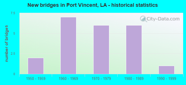
- New bridges - historical statistics
- 21950-1959
- 71960-1969
- 61970-1979
- 61980-1989
- 11990-1999
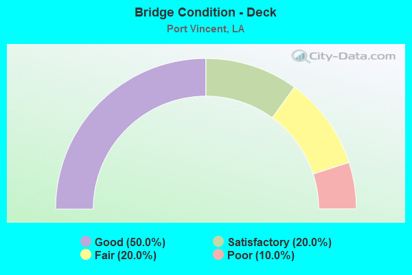
- Bridge Condition - Deck
- 50.0%Good
- 20.0%Satisfactory
- 20.0%Fair
- 10.0%Poor
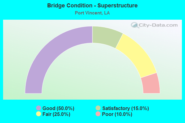
- Bridge Condition - Superstructure
- 50.0%Good
- 15.0%Satisfactory
- 25.0%Fair
- 10.0%Poor
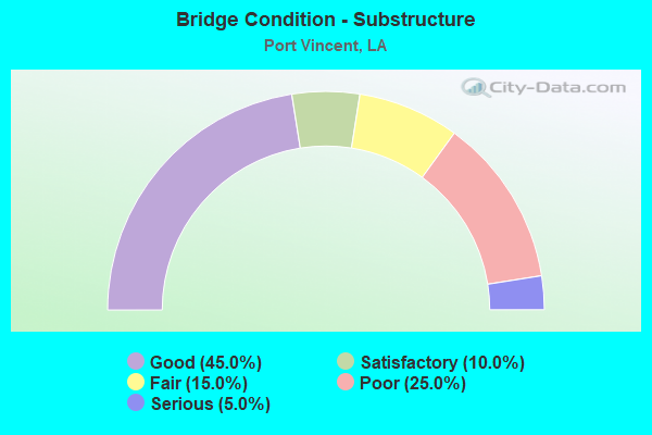
- Bridge Condition - Substructure
- 45.0%Good
- 10.0%Satisfactory
- 15.0%Fair
- 25.0%Poor
- 5.0%Serious
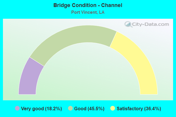
- Bridge Condition - Channel
- 18.2%Very good
- 45.5%Good
- 36.4%Satisfactory
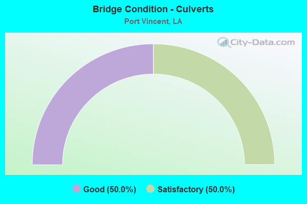
- Bridge Condition - Culverts
- 50.0%Good
- 50.0%Satisfactory
Find on map >> Show street view
Structure Number: 610302670208881, Location: 0.92 MI S JCT LA 42-LA431 (Lat: 30.319669, Lng: -90.853689), Route carried "on" structure: State highway 431, Year Built: 1983, Status: Open, Structure Length: 6.95m (22.80ft), Average Daily Traffic: 12,200 (year 2016), Truck Traffic: 7%, Average Future Daily Traffic: 14,620 (year 2036), Design Load: HS 20, Features Intersected: LAKE VILLAR
Minimum Vertical Clearance: 30+ m (98+ ft), Kilometerpoint: 14.177, Lanes on structure: 2, Owner: State Highway Agency, Approaching Roadway Width: 13.4m (44.0ft), Material/Design: Concrete, Design/Construction: Slab, Number Of Spans In Main Unit: 12, Length of Maximum Span: 5.8m (19.0ft), Curb-To-Curb Width: 12.2m (40.0ft), Out-to-Out Width: 13.1m (43.0ft)
Condition: Deck: Satisfactory, Superstructure: Satisfactory, Substructure: Fair, Channel: Very good, Operating Rating: 60.8 metric tons, Method Used To Determine Operating Rating: Load Factor (LF), Inventory Rating: 36.3 metric tons, Method Used To Determine Inventory Rating: Load Factor (LF), Structural Evaluation: Somewhat better than minimum adequacy, Deck Geometry: Somewhat better than minimum adequacy, Waterway Adequacy: Better than present minimum criteria, Approach Roadway Alignment: Equal to present desirable criteria, Designated Inspection Frequency: Every 24 months, Underwater Inspection Frequency: Every 60 months, Inspection Date: July 2020, Underwater Inspection Date: April 2019, Deck Structure Type: Concrete Cast-file-Place, Wearing Surface/Protective System: Wearing Surface: Bituminous
Find on map >> Show street view
Structure Number: 610302670209481, Location: 0.2 M S of LA 42&LA 431 (Lat: 30.328150, Lng: -90.853731), Route carried "on" structure: State highway 431, Year Built: 1971, Status: Posted for load, Structure Length: 1.80m (5.91ft), Average Daily Traffic: 12,200 (year 2016), Truck Traffic: 7%, Average Future Daily Traffic: 14,620 (year 2036), Design Load: HS 20, Features Intersected: VILLAR CANAL
Minimum Vertical Clearance: 30+ m (98+ ft), Kilometerpoint: 15.120, Lanes on structure: 2, Owner: State Highway Agency, Approaching Roadway Width: 10.7m (35.1ft), Material/Design: Concrete, Design/Construction: Slab, Number Of Spans In Main Unit: 3, Length of Maximum Span: 5.8m (19.0ft), Curb-To-Curb Width: 8.5m (27.9ft), Out-to-Out Width: 9.4m (30.8ft)
Condition: Deck: Fair, Superstructure: Fair, Substructure: Poor, Channel: Very good, Operating Rating: 26.6 metric tons, Method Used To Determine Operating Rating: Load and Resistance Factor Rating (LRFR) rating reported by rating factor(RF) method using HL-93 loadings, Inventory Rating: 20.4 metric tons, Method Used To Determine Inventory Rating: Load and Resistance Factor Rating (LRFR) rating reported by rating factor(RF) method using HL-93 loadings, Structural Evaluation: Meets minimum limits, Deck Geometry: High priority of replacement, Waterway Adequacy: Equal to present desirable criteria, Approach Roadway Alignment: Equal to present desirable criteria, Bridge Posting: Required (Relationship of Operating Rating to Maximum Legal Load: 20.0 - 29.9% below), Length Of Structure Improvement: 2.50m (8.20ft), Designated Inspection Frequency: Every 24 months, Other Special Inspection Frequency: Every 12 months, Inspection Date: January 2022, Other Special Inspection Date: January 2021, Bridge Improvement Cost: $213,000, Total Project Cost: $319,000 ( Estimate for 2016), Deck Structure Type: Concrete Cast-file-Place, Wearing Surface/Protective System: Wearing Surface: Bituminous
Find on map >> Show street view
Structure Number: 610302670209621, Location: 0.09 M S of LA 42&LA 431 (Lat: 30.330231, Lng: -90.853361), Route carried "on" structure: State highway 431, Year Built: 1971, Status: Posted for load, Structure Length: 1.80m (5.91ft), Average Daily Traffic: 12,200 (year 2016), Truck Traffic: 7%, Average Future Daily Traffic: 14,620 (year 2036), Design Load: HS 20, Features Intersected: VILLAR DRAINAGE
Minimum Vertical Clearance: 30+ m (98+ ft), Kilometerpoint: 15.353, Lanes on structure: 2, Owner: State Highway Agency, Approaching Roadway Width: 10.7m (35.1ft), Material/Design: Concrete, Design/Construction: Slab, Number Of Spans In Main Unit: 3, Length of Maximum Span: 5.8m (19.0ft), Curb-To-Curb Width: 8.5m (27.9ft), Out-to-Out Width: 9.4m (30.8ft)
Condition: Deck: Poor, Superstructure: Poor, Substructure: Poor, Channel: Very good, Operating Rating: 23.7 metric tons, Method Used To Determine Operating Rating: Load and Resistance Factor Rating (LRFR) rating reported by rating factor(RF) method using HL-93 loadings, Inventory Rating: 18.1 metric tons, Method Used To Determine Inventory Rating: Load and Resistance Factor Rating (LRFR) rating reported by rating factor(RF) method using HL-93 loadings, Structural Evaluation: Meets minimum limits, Deck Geometry: High priority of replacement, Waterway Adequacy: Equal to present desirable criteria, Approach Roadway Alignment: Equal to present desirable criteria, Bridge Posting: Required (Relationship of Operating Rating to Maximum Legal Load: 20.0 - 29.9% below), Length Of Structure Improvement: 2.50m (8.20ft), Designated Inspection Frequency: Every 24 months, Other Special Inspection Frequency: Every 12 months, Inspection Date: January 2020, Other Special Inspection Date: January 2021, Bridge Improvement Cost: $213,000, Total Project Cost: $319,000 ( Estimate for 2016), Deck Structure Type: Concrete Cast-file-Place, Wearing Surface/Protective System: Wearing Surface: Bituminous
Find on map >> Show street view
Structure Number: 610308031701371, Location: 1.3 M SW of LA 431&LA 931 (Lat: 30.302111, Lng: -90.865811), Route carried "on" structure: State highway 931, Year Built: 1963, Status: Open, Structure Length: 2.44m (8.01ft), Average Daily Traffic: 5,800 (year 2016), Truck Traffic: 24%, Average Future Daily Traffic: 12,750 (year 2036), Design Load: HS 20, Features Intersected: BAYOU MILLET
Minimum Vertical Clearance: 30+ m (98+ ft), Kilometerpoint: 2.058, Lanes on structure: 2, Owner: State Highway Agency, Approaching Roadway Width: 10.7m (35.1ft), Material/Design: Concrete, Design/Construction: Slab, Number Of Spans In Main Unit: 4, Length of Maximum Span: 6.1m (20.0ft), Curb-To-Curb Width: 7.3m (24.0ft), Out-to-Out Width: 8.9m (29.2ft)
Condition: Deck: Good, Superstructure: Good, Substructure: Good, Channel: Satisfactory, Operating Rating: 39.0 metric tons, Method Used To Determine Operating Rating: Load Factor (LF), Inventory Rating: 23.6 metric tons, Method Used To Determine Inventory Rating: Load Factor (LF), Structural Evaluation: Somewhat better than minimum adequacy, Deck Geometry: High priority of replacement, Waterway Adequacy: Equal to present desirable criteria, Approach Roadway Alignment: Equal to present desirable criteria, Length Of Structure Improvement: 3.23m (10.60ft), Designated Inspection Frequency: Every 24 months, Inspection Date: May 2020, Bridge Improvement Cost: $275,000, Total Project Cost: $412,000 ( Estimate for 2016), Deck Structure Type: Concrete Cast-file-Place, Wearing Surface/Protective System: Wearing Surface: Monolithic Concrete
Find on map >> Show street view
Structure Number: 610330193905081, Location: .9 MI.S.OF PORT VINC (Lat: 30.318939, Lng: -90.848511), Route carried "on" structure: County highway , Year Built: 1975, Status: Posted for load, Structure Length: 2.38m (7.81ft), Average Daily Traffic: 250 (year 2019), Average Future Daily Traffic: 102 (year 2036), Design Load: HS 20, Features Intersected: LAKE VILLARS, Facility Carried by Structure: Summerfield Rd
Minimum Vertical Clearance: 30+ m (98+ ft), Kilometerpoint: 0.000, Lanes on structure: 2, Owner: County Highway Agency, Approaching Roadway Width: 8.2m (26.9ft), Material/Design: Concrete, Design/Construction: Slab, Number Of Spans In Main Unit: 4, Length of Maximum Span: 5.8m (19.0ft), Curb-To-Curb Width: 7.3m (24.0ft), Out-to-Out Width: 8.4m (27.6ft)
Condition: Deck: Good, Superstructure: Good, Substructure: Poor, Channel: Good, Operating Rating: 22.7 metric tons, Method Used To Determine Operating Rating: Load and Resistance Factor Rating (LRFR) rating reported by rating factor(RF) method using HL-93 loadings, Inventory Rating: 17.5 metric tons, Method Used To Determine Inventory Rating: Load and Resistance Factor Rating (LRFR) rating reported by rating factor(RF) method using HL-93 loadings, Structural Evaluation: Meets minimum limits, Deck Geometry: Somewhat better than minimum adequacy, Waterway Adequacy: Equal to present desirable criteria, Approach Roadway Alignment: Equal to present minimum criteria, Length Of Structure Improvement: 3.14m (10.30ft), Designated Inspection Frequency: Every 24 months, Other Special Inspection Frequency: Every 12 months, Inspection Date: April 2021, Other Special Inspection Date: May 2020, Bridge Improvement Cost: $187,000, Total Project Cost: $280,000 ( Estimate for 2016), Deck Structure Type: Concrete Precast Panels, Wearing Surface/Protective System: Wearing Surface: Bituminous
Find on map >> Show street view
Structure Number: 610330193905091, Location: .9 MI.S.OF PORT VINC (Lat: 30.319519, Lng: -90.847981), Route carried "on" structure: County highway , Year Built: 1975, Status: Posted for load, Structure Length: 2.38m (7.81ft), Average Daily Traffic: 250 (year 2019), Average Future Daily Traffic: 102 (year 2036), Design Load: HS 20, Features Intersected: LAKE VILLAKS, Facility Carried by Structure: Summerfield Rd
Minimum Vertical Clearance: 30+ m (98+ ft), Kilometerpoint: 0.000, Lanes on structure: 2, Owner: County Highway Agency, Approaching Roadway Width: 8.2m (26.9ft), Material/Design: Concrete, Design/Construction: Slab, Number Of Spans In Main Unit: 4, Length of Maximum Span: 5.8m (19.0ft), Curb-To-Curb Width: 7.3m (24.0ft), Out-to-Out Width: 8.3m (27.2ft)
Condition: Deck: Satisfactory, Superstructure: Satisfactory, Substructure: Poor, Channel: Satisfactory, Operating Rating: 22.7 metric tons, Method Used To Determine Operating Rating: Load and Resistance Factor Rating (LRFR) rating reported by rating factor(RF) method using HL-93 loadings, Inventory Rating: 17.5 metric tons, Method Used To Determine Inventory Rating: Load and Resistance Factor Rating (LRFR) rating reported by rating factor(RF) method using HL-93 loadings, Structural Evaluation: Meets minimum limits, Deck Geometry: Somewhat better than minimum adequacy, Waterway Adequacy: Equal to present desirable criteria, Approach Roadway Alignment: Better than present minimum criteria, Length Of Structure Improvement: 3.14m (10.30ft), Designated Inspection Frequency: Every 24 months, Other Special Inspection Frequency: Every 12 months, Inspection Date: April 2021, Other Special Inspection Date: May 2020, Bridge Improvement Cost: $187,000, Total Project Cost: $280,000 ( Estimate for 2016), Deck Structure Type: Concrete Precast Panels, Wearing Surface/Protective System: Wearing Surface: Bituminous
Find on map >> Show street view
Structure Number: 610330204905221, Location: 1.2 M NW OF PORT VINCENT (Lat: 30.340611, Lng: -90.869111), Route carried "on" structure: County highway , Year Built: 1989, Status: Posted for load, Structure Length: 0.76m (2.49ft), Average Daily Traffic: 10 (year 2019), Average Future Daily Traffic: 102 (year 2036), Design Load: H 10, Features Intersected: DRAINAGE BAYOU, Facility Carried by Structure: H H Wilson Rd
Minimum Vertical Clearance: 30+ m (98+ ft), Kilometerpoint: 0.000, Lanes on structure: 1, Owner: County Highway Agency, Approaching Roadway Width: 6.4m (21.0ft), Material/Design: Wood or Timber, Design/Construction: Stringer/Multi-beam, Number Of Spans In Main Unit: 2, Length of Maximum Span: 4.0m (13.1ft), Curb-To-Curb Width: 4.9m (16.1ft), Out-to-Out Width: 5.8m (19.0ft)
Condition: Deck: Poor, Superstructure: Poor, Substructure: Serious, Channel: Satisfactory, Operating Rating: 19.0 metric tons, Method Used To Determine Operating Rating: Allowable Stress (AS), Inventory Rating: 14.5 metric tons, Method Used To Determine Inventory Rating: Allowable Stress (AS), Structural Evaluation: High priority of corrective action, Deck Geometry: High priority of corrective action, Waterway Adequacy: Better than present minimum criteria, Approach Roadway Alignment: Equal to present minimum criteria, Bridge Posting: Required (Relationship of Operating Rating to Maximum Legal Load: 20.0 - 29.9% below), Length Of Structure Improvement: 1.37m (4.49ft), Designated Inspection Frequency: Every 24 months, Other Special Inspection Frequency: Every 12 months, Inspection Date: April 2021, Other Special Inspection Date: May 2020, Bridge Improvement Cost: $81,000, Total Project Cost: $121,000 ( Estimate for 2016), Deck Structure Type: Wood or Timber
Find on map >> Show street view
Structure Number: 623202600201061, Location: 1.0 M E OF LA 42 (Lat: 30.335550, Lng: -90.838200), Route carried "on" structure: State highway 16, Year Built: 1951, Status: Open, Structure Length: 1.04m (3.41ft), Average Daily Traffic: 10,600 (year 2016), Truck Traffic: 11%, Average Future Daily Traffic: 8,858 (year 2036), Design Load: H 15, Features Intersected: DRAIN
Minimum Vertical Clearance: 30+ m (98+ ft), Kilometerpoint: 1.706, Lanes on structure: 2, Base Highway Network: Yes (Inventory Route: 260-02-1, Subroute: 10), Owner: State Highway Agency, Approaching Roadway Width: 9.1m (29.9ft), Material/Design: Concrete, Design/Construction: Culvert, Number Of Spans In Main Unit: 5, Length of Maximum Span: 1.8m (5.9ft), Curb-To-Curb Width: 6.7m (22.0ft), Out-to-Out Width: 7.9m (25.9ft)
Condition: Channel: Satisfactory, Culverts: Satisfactory, Operating Rating: 25.6 metric tons, Method Used To Determine Operating Rating: Load and Resistance Factor Rating (LRFR) rating reported by rating factor(RF) method using HL-93 loadings, Inventory Rating: 19.8 metric tons, Method Used To Determine Inventory Rating: Load and Resistance Factor Rating (LRFR) rating reported by rating factor(RF) method using HL-93 loadings, Structural Evaluation: Somewhat better than minimum adequacy, Deck Geometry: High priority of replacement, Waterway Adequacy: Equal to present minimum criteria, Approach Roadway Alignment: Equal to present desirable criteria, Designated Inspection Frequency: Every 24 months, Inspection Date: January 2020, Deck Structure Type: Concrete Cast-file-Place
Find on map >> Show street view
Structure Number: 623202600202191, Location: LA0016 (Lat: 30.326789, Lng: -90.823400), Route carried "on" structure: State highway 16, Year Built: 1979, Status: Open, Structure Length: 20.73m (68.01ft), Average Daily Traffic: 8,700 (year 2016), Truck Traffic: 11%, Average Future Daily Traffic: 7,310 (year 2036), Design Load: HS 20, Features Intersected: COLYELL BAY
Minimum Vertical Clearance: 30+ m (98+ ft), Kilometerpoint: 3.504, Lanes on structure: 2, Base Highway Network: Yes (Inventory Route: 260-02-1, Subroute: 10), Owner: State Highway Agency, Approaching Roadway Width: 7.6m (24.9ft), Material/Design: Prestressed concrete, Design/Construction: Stringer/Multi-beam, Number Of Spans In Main Unit: 33, Length of Maximum Span: 12.2m (40.0ft), Curb-To-Curb Width: 12.2m (40.0ft), Out-to-Out Width: 13.1m (43.0ft)
Condition: Deck: Good, Superstructure: Good, Substructure: Good, Channel: Good, Operating Rating: 64.4 metric tons, Method Used To Determine Operating Rating: Load Factor (LF), Inventory Rating: 38.1 metric tons, Method Used To Determine Inventory Rating: Load Factor (LF), Structural Evaluation: Better than present minimum criteria, Deck Geometry: Somewhat better than minimum adequacy, Waterway Adequacy: Better than present minimum criteria, Approach Roadway Alignment: Better than present minimum criteria, Designated Inspection Frequency: Every 24 months, Underwater Inspection Frequency: Every 60 months, Inspection Date: January 2020, Underwater Inspection Date: July 2019, Deck Structure Type: Concrete Cast-file-Place
Find on map >> Show street view
Structure Number: 623202600207091, Location: LA0016 (Lat: 30.281039, Lng: -90.784500), Route carried "on" structure: State highway 16, Year Built: 1960, Status: Open, Structure Length: 3.66m (12.01ft), Average Daily Traffic: 5,600 (year 2016), Truck Traffic: 11%, Average Future Daily Traffic: 4,730 (year 2036), Design Load: HS 20, Features Intersected: BAYOU KING GEORGE
Minimum Vertical Clearance: 30+ m (98+ ft), Kilometerpoint: 11.301, Lanes on structure: 2, Base Highway Network: Yes (Inventory Route: 260-02-1, Subroute: 10), Owner: State Highway Agency, Approaching Roadway Width: 9.1m (29.9ft), Material/Design: Concrete, Design/Construction: Slab, Number Of Spans In Main Unit: 6, Length of Maximum Span: 6.1m (20.0ft), Curb-To-Curb Width: 7.3m (24.0ft), Out-to-Out Width: 8.9m (29.2ft)
Condition: Deck: Good, Superstructure: Good, Substructure: Good, Channel: Satisfactory, Operating Rating: 39.0 metric tons, Method Used To Determine Operating Rating: Load Factor (LF), Inventory Rating: 23.6 metric tons, Method Used To Determine Inventory Rating: Load Factor (LF), Structural Evaluation: Somewhat better than minimum adequacy, Deck Geometry: High priority of replacement, Waterway Adequacy: Equal to present minimum criteria, Approach Roadway Alignment: Equal to present desirable criteria, Length Of Structure Improvement: 4.57m (14.99ft), Designated Inspection Frequency: Every 24 months, Inspection Date: January 2022, Bridge Improvement Cost: $390,000, Total Project Cost: $585,000 ( Estimate for 2016), Deck Structure Type: Concrete Cast-file-Place
Find on map >> Show street view
Structure Number: 623202600207381, Location: 1.5 M S OF LA 444 (Lat: 30.277811, Lng: -90.781400), Route carried "on" structure: State highway 16, Year Built: 1960, Status: Open, Structure Length: 2.44m (8.01ft), Average Daily Traffic: 5,600 (year 2016), Truck Traffic: 11%, Average Future Daily Traffic: 4,730 (year 2036), Design Load: HS 20, Features Intersected: AMITE RIVER REL
Minimum Vertical Clearance: 30+ m (98+ ft), Kilometerpoint: 11.766, Lanes on structure: 2, Base Highway Network: Yes (Inventory Route: 260-02-1, Subroute: 10), Owner: State Highway Agency, Approaching Roadway Width: 9.1m (29.9ft), Material/Design: Concrete, Design/Construction: Slab, Number Of Spans In Main Unit: 4, Length of Maximum Span: 6.1m (20.0ft), Curb-To-Curb Width: 7.3m (24.0ft), Out-to-Out Width: 9.0m (29.5ft)
Condition: Deck: Satisfactory, Superstructure: Satisfactory, Substructure: Good, Channel: Satisfactory, Operating Rating: 39.0 metric tons, Method Used To Determine Operating Rating: Load Factor (LF), Inventory Rating: 23.6 metric tons, Method Used To Determine Inventory Rating: Load Factor (LF), Structural Evaluation: Somewhat better than minimum adequacy, Deck Geometry: High priority of replacement, Waterway Adequacy: Equal to present minimum criteria, Approach Roadway Alignment: Equal to present desirable criteria, Length Of Structure Improvement: 3.23m (10.60ft), Designated Inspection Frequency: Every 24 months, Inspection Date: January 2022, Bridge Improvement Cost: $275,000, Total Project Cost: $412,000 ( Estimate for 2016), Deck Structure Type: Concrete Cast-file-Place
Find on map >> Show street view
Structure Number: 623202600207511, Location: 1.6 M S OF LA 444 (Lat: 30.276400, Lng: -90.780100), Route carried "on" structure: State highway 16, Year Built: 1960, Status: Posted for load, Structure Length: 28.38m (93.11ft), Average Daily Traffic: 5,600 (year 2016), Truck Traffic: 11%, Average Future Daily Traffic: 4,730 (year 2036), Design Load: H 15, Features Intersected: AMITE RIVER-FRENCH S'MEN
Minimum Vertical Clearance: 30+ m (98+ ft), Kilometerpoint: 11.964, Lanes on structure: 2, Base Highway Network: Yes (Inventory Route: 260-02-1, Subroute: 10), Owner: State Highway Agency, Approaching Roadway Width: 9.1m (29.9ft), Navigation Control: Yes ( Vertical Clearance: 5.2m (17.1ft), Horizontal Clearance: 18.6m (61.0ft)), Material/Design: Steel, Design/Construction: Movable - Swing, Number Of Spans In Main Unit: 1, Number Of Approach Spans: 18, Length of Maximum Span: 62.2m (204.1ft), Curb-To-Curb Width: 7.3m (24.0ft), Out-to-Out Width: 8.3m (27.2ft)
Condition: Deck: Fair, Superstructure: Fair, Substructure: Satisfactory, Channel: Good, Operating Rating: 23.6 metric tons, Method Used To Determine Operating Rating: Allowable Stress (AS), Inventory Rating: 6.3 metric tons, Method Used To Determine Inventory Rating: Allowable Stress (AS), Structural Evaluation: High priority of replacement, Deck Geometry: High priority of replacement, Waterway Adequacy: Better than present minimum criteria, Approach Roadway Alignment: Better than present minimum criteria, Bridge Posting: Required (Relationship of Operating Rating to Maximum Legal Load: 20.0 - 29.9% below), Length Of Structure Improvement: 28.62m (93.90ft), Designated Inspection Frequency: Every 24 months, Critical Feature Inspection Frequency: Every 24 months, Underwater Inspection Frequency: Every 60 months, Inspection Date: December 2020, Critical Feature Inspection Date: December 2020, Underwater Inspection Date: June 2019, Bridge Improvement Cost: $2,441,000, Total Project Cost: $3,661,000 ( Estimate for 2016), Deck Structure Type: Concrete Cast-file-Place
Find on map >> Show street view
Structure Number: 623202620100861, Location: 0.8 M N OF LA 42 (Lat: 30.343869, Lng: -90.846800), Route carried "on" structure: State highway 16, Year Built: 1974, Status: Open, Structure Length: 2.35m (7.71ft), Average Daily Traffic: 12,300 (year 2016), Truck Traffic: 8%, Average Future Daily Traffic: 10,406 (year 2036), Design Load: HS 20, Features Intersected: SLOUGH
Minimum Vertical Clearance: 30+ m (98+ ft), Kilometerpoint: 1.353, Lanes on structure: 2, Owner: State Highway Agency, Approaching Roadway Width: 9.8m (32.2ft), Material/Design: Concrete, Design/Construction: Slab, Number Of Spans In Main Unit: 4, Length of Maximum Span: 5.8m (19.0ft), Curb-To-Curb Width: 9.8m (32.2ft), Out-to-Out Width: 10.7m (35.1ft)
Condition: Deck: Fair, Superstructure: Fair, Substructure: Fair, Channel: Good, Operating Rating: 62.6 metric tons, Method Used To Determine Operating Rating: Load Factor (LF), Inventory Rating: 37.2 metric tons, Method Used To Determine Inventory Rating: Load Factor (LF), Structural Evaluation: Somewhat better than minimum adequacy, Deck Geometry: Meets minimum limits, Waterway Adequacy: Better than present minimum criteria, Approach Roadway Alignment: Equal to present desirable criteria, Designated Inspection Frequency: Every 24 months, Inspection Date: April 2020, Deck Structure Type: Concrete Precast Panels, Wearing Surface/Protective System: Wearing Surface: Bituminous
Find on map >> Show street view
Structure Number: 623202620101601, Location: 2.0 M SE OF LA 1032 (Lat: 30.353631, Lng: -90.846600), Route carried "on" structure: State highway 16, Year Built: 1982, Status: Open, Structure Length: 2.38m (7.81ft), Average Daily Traffic: 12,300 (year 2016), Truck Traffic: 8%, Average Future Daily Traffic: 10,406 (year 2036), Design Load: HS 20, Features Intersected: WILLIS BAYOU
Minimum Vertical Clearance: 30+ m (98+ ft), Kilometerpoint: 2.594, Lanes on structure: 2, Owner: State Highway Agency, Approaching Roadway Width: 12.2m (40.0ft), Material/Design: Concrete, Design/Construction: Slab, Number Of Spans In Main Unit: 4, Length of Maximum Span: 5.8m (19.0ft), Curb-To-Curb Width: 12.2m (40.0ft), Out-to-Out Width: 13.1m (43.0ft)
Condition: Deck: Fair, Superstructure: Fair, Substructure: Poor, Channel: Good, Operating Rating: 61.7 metric tons, Method Used To Determine Operating Rating: Load Factor (LF), Inventory Rating: 37.2 metric tons, Method Used To Determine Inventory Rating: Load Factor (LF), Structural Evaluation: Meets minimum limits, Deck Geometry: Somewhat better than minimum adequacy, Waterway Adequacy: Better than present minimum criteria, Approach Roadway Alignment: Equal to present desirable criteria, Designated Inspection Frequency: Every 24 months, Other Special Inspection Frequency: Every 12 months, Inspection Date: April 2020, Other Special Inspection Date: April 2021, Deck Structure Type: Concrete Precast Panels, Wearing Surface/Protective System: Wearing Surface: Bituminous
Find on map >> Show street view
Structure Number: 623202620105101, Location: 1.3 M NW OF LA 1032 (Lat: 30.384669, Lng: -90.874700), Route carried "on" structure: State highway 16, Year Built: 1980, Status: Open, Structure Length: 1.77m (5.81ft), Average Daily Traffic: 6,200 (year 2016), Truck Traffic: 8%, Average Future Daily Traffic: 5,246 (year 2036), Design Load: HS 20, Features Intersected: DRAIN
Minimum Vertical Clearance: 30+ m (98+ ft), Kilometerpoint: 8.159, Lanes on structure: 2, Owner: State Highway Agency, Approaching Roadway Width: 11.6m (38.1ft), Material/Design: Concrete, Design/Construction: Slab, Number Of Spans In Main Unit: 3, Length of Maximum Span: 5.8m (19.0ft), Curb-To-Curb Width: 12.2m (40.0ft), Out-to-Out Width: 13.1m (43.0ft)
Condition: Deck: Good, Superstructure: Good, Substructure: Satisfactory, Channel: Very good, Operating Rating: 61.7 metric tons, Method Used To Determine Operating Rating: Load Factor (LF), Inventory Rating: 37.2 metric tons, Method Used To Determine Inventory Rating: Load Factor (LF), Structural Evaluation: Equal to present minimum criteria, Deck Geometry: Somewhat better than minimum adequacy, Waterway Adequacy: Equal to present desirable criteria, Approach Roadway Alignment: Equal to present desirable criteria, Designated Inspection Frequency: Every 24 months, Inspection Date: April 2020, Deck Structure Type: Concrete Precast Panels, Wearing Surface/Protective System: Wearing Surface: Bituminous
Find on map >> Show street view
Structure Number: 623202680100311, Location: 0.2 M N OF LA 16 (Lat: 30.359531, Lng: -90.847700), Route carried "on" structure: State highway 447, Year Built: 1962, Status: Open, Structure Length: 1.83m (6.00ft), Average Daily Traffic: 6,600 (year 2016), Truck Traffic: 8%, Average Future Daily Traffic: 5,590 (year 2036), Design Load: HS 20, Features Intersected: WILLIS BAYOU
Minimum Vertical Clearance: 30+ m (98+ ft), Kilometerpoint: 0.483, Lanes on structure: 2, Owner: State Highway Agency, Approaching Roadway Width: 9.1m (29.9ft), Material/Design: Concrete, Design/Construction: Slab, Number Of Spans In Main Unit: 3, Length of Maximum Span: 6.1m (20.0ft), Curb-To-Curb Width: 7.3m (24.0ft), Out-to-Out Width: 9.0m (29.5ft)
Condition: Deck: Good, Superstructure: Good, Substructure: Good, Channel: Good, Operating Rating: 37.2 metric tons, Method Used To Determine Operating Rating: Load Factor (LF), Inventory Rating: 22.7 metric tons, Method Used To Determine Inventory Rating: Load Factor (LF), Structural Evaluation: Somewhat better than minimum adequacy, Deck Geometry: High priority of replacement, Waterway Adequacy: Better than present minimum criteria, Approach Roadway Alignment: Equal to present desirable criteria, Length Of Structure Improvement: 2.56m (8.40ft), Designated Inspection Frequency: Every 24 months, Inspection Date: March 2020, Bridge Improvement Cost: $218,000, Total Project Cost: $327,000 ( Estimate for 2016), Deck Structure Type: Concrete Cast-file-Place, Wearing Surface/Protective System: Wearing Surface: Bituminous
Find on map >> Show street view
Structure Number: 623202680102371, Location: 2.0 M N OF LA 16 (Lat: 30.385250, Lng: -90.854200), Route carried "on" structure: State highway 447, Year Built: 1962, Status: Open, Structure Length: 2.44m (8.01ft), Average Daily Traffic: 6,600 (year 2016), Truck Traffic: 8%, Average Future Daily Traffic: 5,590 (year 2036), Design Load: HS 20, Features Intersected: DRAIN
Minimum Vertical Clearance: 30+ m (98+ ft), Kilometerpoint: 3.809, Lanes on structure: 2, Owner: State Highway Agency, Approaching Roadway Width: 9.1m (29.9ft), Material/Design: Concrete, Design/Construction: Slab, Number Of Spans In Main Unit: 4, Length of Maximum Span: 6.1m (20.0ft), Curb-To-Curb Width: 7.3m (24.0ft), Out-to-Out Width: 9.0m (29.5ft)
Condition: Deck: Good, Superstructure: Good, Substructure: Good, Channel: Good, Operating Rating: 37.2 metric tons, Method Used To Determine Operating Rating: Load Factor (LF), Inventory Rating: 22.7 metric tons, Method Used To Determine Inventory Rating: Load Factor (LF), Structural Evaluation: Somewhat better than minimum adequacy, Deck Geometry: High priority of replacement, Waterway Adequacy: Better than present minimum criteria, Approach Roadway Alignment: Equal to present desirable criteria, Length Of Structure Improvement: 3.23m (10.60ft), Designated Inspection Frequency: Every 24 months, Inspection Date: March 2020, Bridge Improvement Cost: $275,000, Total Project Cost: $412,000 ( Estimate for 2016), Deck Structure Type: Concrete Cast-file-Place, Wearing Surface/Protective System: Wearing Surface: Bituminous
Find on map >> Show street view
Structure Number: 623202680103231, Location: 3.0 M N OF LA 16 (Lat: 30.397881, Lng: -90.854300), Route carried "on" structure: State highway 447, Year Built: 1962, Status: Open, Structure Length: 2.44m (8.01ft), Average Daily Traffic: 6,600 (year 2016), Truck Traffic: 8%, Average Future Daily Traffic: 5,590 (year 2036), Design Load: HS 20, Features Intersected: FELDER BAYOU
Minimum Vertical Clearance: 30+ m (98+ ft), Kilometerpoint: 5.209, Lanes on structure: 2, Owner: State Highway Agency, Approaching Roadway Width: 9.1m (29.9ft), Material/Design: Concrete, Design/Construction: Slab, Number Of Spans In Main Unit: 4, Length of Maximum Span: 6.1m (20.0ft), Curb-To-Curb Width: 7.3m (24.0ft), Out-to-Out Width: 9.0m (29.5ft)
Condition: Deck: Good, Superstructure: Good, Substructure: Good, Channel: Good, Operating Rating: 37.2 metric tons, Method Used To Determine Operating Rating: Load Factor (LF), Inventory Rating: 22.7 metric tons, Method Used To Determine Inventory Rating: Load Factor (LF), Structural Evaluation: Somewhat better than minimum adequacy, Deck Geometry: High priority of replacement, Waterway Adequacy: Better than present minimum criteria, Approach Roadway Alignment: Equal to present desirable criteria, Length Of Structure Improvement: 3.23m (10.60ft), Designated Inspection Frequency: Every 24 months, Inspection Date: March 2020, Bridge Improvement Cost: $275,000, Total Project Cost: $412,000 ( Estimate for 2016), Deck Structure Type: Concrete Cast-file-Place, Wearing Surface/Protective System: Wearing Surface: Bituminous
Find on map >> Show street view
Structure Number: 623208321200221, Location: LA1032 (Lat: 30.369139, Lng: -90.869800), Route carried "on" structure: State highway 1032, Year Built: 1956, Status: Posted for load, Structure Length: 3.54m (11.61ft), Average Daily Traffic: 6,800 (year 2016), Truck Traffic: 9%, Average Future Daily Traffic: 5,762 (year 2036), Design Load: H 15, Features Intersected: GRAYS CREEK
Minimum Vertical Clearance: 30+ m (98+ ft), Kilometerpoint: 0.352, Lanes on structure: 2, Owner: State Highway Agency, Approaching Roadway Width: 8.8m (28.9ft), Material/Design: Wood or Timber, Design/Construction: Stringer/Multi-beam, Number Of Spans In Main Unit: 6, Length of Maximum Span: 5.8m (19.0ft), Curb-To-Curb Width: 7.6m (24.9ft), Out-to-Out Width: 8.4m (27.6ft)
Condition: Deck: Satisfactory, Superstructure: Fair, Substructure: Fair, Channel: Satisfactory, Operating Rating: 20.0 metric tons, Method Used To Determine Operating Rating: Allowable Stress (AS), Inventory Rating: 14.5 metric tons, Method Used To Determine Inventory Rating: Allowable Stress (AS), Structural Evaluation: High priority of replacement, Deck Geometry: High priority of replacement, Waterway Adequacy: Better than present minimum criteria, Approach Roadway Alignment: Better than present minimum criteria, Bridge Posting: Required (Relationship of Operating Rating to Maximum Legal Load: 10.0 - 19.9% below), Length Of Structure Improvement: 4.42m (14.50ft), Designated Inspection Frequency: Every 24 months, Inspection Date: April 2020, Bridge Improvement Cost: $377,000, Total Project Cost: $565,000 ( Estimate for 2016), Deck Structure Type: Wood or Timber, Wearing Surface/Protective System: Wearing Surface: Bituminous
Find on map >> Show street view
Structure Number: 623230229905291, Location: 7.5 MI SE OF LA 3002 EXIT (Lat: 30.383331, Lng: -90.882539), Route carried "on" structure: County highway , Year Built: 1985, Status: Posted for load, Structure Length: 2.32m (7.61ft), Average Daily Traffic: 30 (year 1974), Average Future Daily Traffic: 25 (year 2036), Design Load: HS 20, Features Intersected: GRAYS CREEK, Facility Carried by Structure: Scivicque Rd
Minimum Vertical Clearance: 30+ m (98+ ft), Kilometerpoint: 0.000, Lanes on structure: 2, Owner: County Highway Agency, Approaching Roadway Width: 7.3m (24.0ft), Material/Design: Concrete, Design/Construction: Slab, Number Of Spans In Main Unit: 4, Length of Maximum Span: 5.8m (19.0ft), Curb-To-Curb Width: 7.3m (24.0ft), Out-to-Out Width: 8.2m (26.9ft)
Condition: Deck: Good, Superstructure: Good, Substructure: Good, Channel: Good, Operating Rating: 51.5 metric tons, Method Used To Determine Operating Rating: Load and Resistance Factor Rating (LRFR) rating reported by rating factor(RF) method using HL-93 loadings, Inventory Rating: 39.9 metric tons, Method Used To Determine Inventory Rating: Load and Resistance Factor Rating (LRFR) rating reported by rating factor(RF) method using HL-93 loadings, Structural Evaluation: Better than present minimum criteria, Deck Geometry: Equal to present minimum criteria, Waterway Adequacy: Better than present minimum criteria, Approach Roadway Alignment: Equal to present desirable criteria, Designated Inspection Frequency: Every 24 months, Inspection Date: August 2020, Deck Structure Type: Concrete Precast Panels
Find on map >> Show street view
Structure Number: 623230235905271, Location: 7.4 MI S OF LS 447 EXIT (Lat: 30.392331, Lng: -90.878950), Route carried "on" structure: County highway , Year Built: 1998, Status: Open, Structure Length: 1.22m (4.00ft), Average Daily Traffic: 400 (year 2016), Average Future Daily Traffic: 344 (year 2036), Design Load: HS 20, Features Intersected: CREEK, Facility Carried by Structure: Hammack Rd
Minimum Vertical Clearance: 30+ m (98+ ft), Kilometerpoint: 0.000, Lanes on structure: 2, Base Highway Network: Yes, Owner: County Highway Agency, Approaching Roadway Width: 10.4m (34.1ft), Skew: 7 degrees, Material/Design: Steel, Design/Construction: Culvert, Number Of Spans In Main Unit: 4, Length of Maximum Span: 2.1m (6.9ft), Curb-To-Curb Width: 7.0m (23.0ft), Out-to-Out Width: 11.0m (36.1ft)
Condition: Channel: Good, Culverts: Good, Operating Rating: 97.2 metric tons, Method Used To Determine Operating Rating: Load and Resistance Factor Rating (LRFR) rating reported by rating factor(RF) method using HL-93 loadings, Inventory Rating: 74.5 metric tons, Method Used To Determine Inventory Rating: Load and Resistance Factor Rating (LRFR) rating reported by rating factor(RF) method using HL-93 loadings, Structural Evaluation: Better than present minimum criteria, Deck Geometry: Meets minimum limits, Waterway Adequacy: Equal to present desirable criteria, Approach Roadway Alignment: Equal to present desirable criteria, Designated Inspection Frequency: Every 24 months, Inspection Date: August 2020
Find on map >> Show street view
Structure Number: 623230237905021, Location: 0.90 M E of LA 447 (Lat: 30.396011, Lng: -90.839361), Route carried "on" structure: County highway , Year Built: 1984, Status: Open, Structure Length: 3.47m (11.38ft), Average Daily Traffic: 170 (year 1974), Average Future Daily Traffic: 146 (year 2036), Design Load: HS 20, Features Intersected: WEST COLYELL CREEK, Facility Carried by Structure: Hood Rd
Minimum Vertical Clearance: 30+ m (98+ ft), Kilometerpoint: 0.000, Lanes on structure: 2, Owner: County Highway Agency, Approaching Roadway Width: 7.9m (25.9ft), Skew: 7 degrees, Material/Design: Concrete, Design/Construction: Slab, Number Of Spans In Main Unit: 6, Length of Maximum Span: 5.8m (19.0ft), Curb-To-Curb Width: 7.3m (24.0ft), Out-to-Out Width: 8.2m (26.9ft)
Condition: Deck: Good, Superstructure: Good, Substructure: Good, Channel: Satisfactory, Operating Rating: 25.9 metric tons, Method Used To Determine Operating Rating: Load and Resistance Factor Rating (LRFR) rating reported by rating factor(RF) method using HL-93 loadings, Inventory Rating: 19.8 metric tons, Method Used To Determine Inventory Rating: Load and Resistance Factor Rating (LRFR) rating reported by rating factor(RF) method using HL-93 loadings, Structural Evaluation: Somewhat better than minimum adequacy, Deck Geometry: Somewhat better than minimum adequacy, Waterway Adequacy: Better than present minimum criteria, Approach Roadway Alignment: Equal to present minimum criteria, Designated Inspection Frequency: Every 24 months, Inspection Date: July 2020, Deck Structure Type: Concrete Cast-file-Place