Bridge Statistics for Porterdale, Georgia (GA)
Condition, Traffic, Stress, Structural Evaluation, Project Costs
- National Bridge Inventory (NBI) Statistics
- 13Number of bridges
- 207ft / 62.5mTotal length
- $14,759,000Total costs
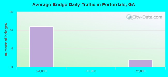
- 203,210Total average daily traffic
- 7,616Total average daily truck traffic
- National Bridge Inventory (NBI) Registered Bridges for Porterdale
- No street view available for this location
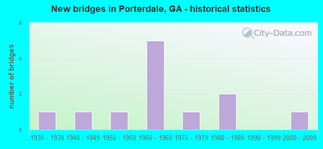
- New bridges - historical statistics
- 11930-1939
- 11940-1949
- 11950-1959
- 51960-1969
- 11970-1979
- 21980-1989
- 12000-2009
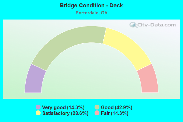
- Bridge Condition - Deck
- 14.3%Very good
- 42.9%Good
- 28.6%Satisfactory
- 14.3%Fair
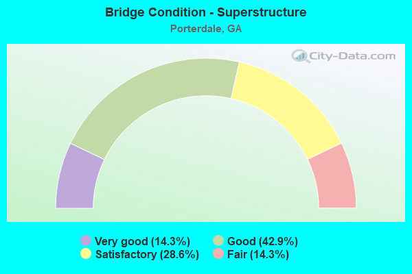
- Bridge Condition - Superstructure
- 14.3%Very good
- 42.9%Good
- 28.6%Satisfactory
- 14.3%Fair
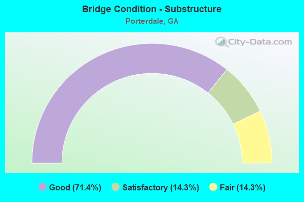
- Bridge Condition - Substructure
- 71.4%Good
- 14.3%Satisfactory
- 14.3%Fair
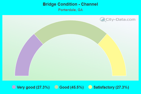
- Bridge Condition - Channel
- 27.3%Very good
- 45.5%Good
- 27.3%Satisfactory
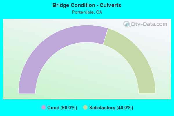
- Bridge Condition - Culverts
- 60.0%Good
- 40.0%Satisfactory
Find on map >> Show street view
Structure Number: 2170012, Location: IN PORTERDALE (Lat: 33.570319, Lng: -83.897158), Route carried "on" structure: State highway 81, Year Built: 1943, Status: Open, Structure Length: 9.51m (31.20ft), Average Daily Traffic: 8,850 (year 2011), Truck Traffic: 1%, Average Future Daily Traffic: 13,275 (year 2031), Design Load: H 15, Features Intersected: YELLOW RIVER
Minimum Vertical Clearance: 30+ m (98+ ft), Kilometerpoint: 12.875, Lanes on structure: 2, Base Highway Network: Yes, Owner: State Highway Agency, Approaching Roadway Width: 15.8m (51.8ft), Skew: 3 degrees, Material/Design: Concrete, Design/Construction: Tee Beam, Number Of Spans In Main Unit: 8, Length of Maximum Span: 11.9m (39.0ft), Curb or Sidewalk Widths: Left: 1.5m (4.9ft), Right: 1.5m (4.9ft), Curb-To-Curb Width: 12.1m (39.7ft), Out-to-Out Width: 15.8m (51.8ft)
Condition: Deck: Satisfactory, Superstructure: Fair, Substructure: Fair, Channel: Very good, Operating Rating: 32.6 metric tons, Method Used To Determine Operating Rating: Allowable Stress (AS), Inventory Rating: 19.0 metric tons, Method Used To Determine Inventory Rating: Allowable Stress (AS), Structural Evaluation: Meets minimum limits, Deck Geometry: Somewhat better than minimum adequacy, Waterway Adequacy: Equal to present desirable criteria, Approach Roadway Alignment: Equal to present minimum criteria, Designated Inspection Frequency: Every 24 months, Underwater Inspection Frequency: Every 60 months, Inspection Date: December 2020, Underwater Inspection Date: September 2018, Bridge Improvement Cost: $1,219,000, Roadway Improvement Cost: $122,000, Total Project Cost: $1,829,000, Deck Structure Type: Concrete Cast-file-Place
Find on map >> Show street view
Structure Number: 2170024, Location: 2 MI W OF COVINGTON (Lat: 33.614750, Lng: -83.914958), Route carried "on" structure: Interstate 20, Year Built: 1964, Year Reconstructed: 1988, Status: Open, Structure Length: 9.63m (31.59ft), Average Daily Traffic: 61,420 (year 2011), Truck Traffic: 1%, Average Future Daily Traffic: 92,130 (year 2031), Design Load: HS 20+Mod, Features Intersected: YELLOW RIVER
Minimum Vertical Clearance: 30+ m (98+ ft), Kilometerpoint: 141.622, Lanes on structure: 6, Base Highway Network: Yes, Owner: State Highway Agency, Approaching Roadway Width: 30.8m (101.0ft), Skew: 30 degrees, Material/Design: Steel continuous, Design/Construction: Stringer/Multi-beam, Number Of Spans In Main Unit: 5, Length of Maximum Span: 27.4m (89.9ft), Curb-To-Curb Width: 33.2m (108.9ft), Out-to-Out Width: 35.1m (115.2ft)
Condition: Deck: Good, Superstructure: Good, Substructure: Good, Channel: Satisfactory, Operating Rating: 55.3 metric tons, Method Used To Determine Operating Rating: Load Factor (LF), Inventory Rating: 33.5 metric tons, Method Used To Determine Inventory Rating: Load Factor (LF), Structural Evaluation: Better than present minimum criteria, Deck Geometry: Superior to present desirable criteria, Waterway Adequacy: Equal to present minimum criteria, Approach Roadway Alignment: Equal to present desirable criteria, Designated Inspection Frequency: Every 24 months, Underwater Inspection Frequency: Every 60 months, Inspection Date: January 2021, Underwater Inspection Date: September 2018, Bridge Improvement Cost: $2,582,000, Roadway Improvement Cost: $258,000, Total Project Cost: $3,872,000, Deck Structure Type: Concrete Cast-file-Place
Find on map >> Show street view
Structure Number: 2170041, Location: 2 MI W OF COVINGTON (Lat: 33.614478, Lng: -83.915019), Route carried "on" structure: County highway 516, Year Built: 1937, Status: Open, Structure Length: 9.45m (31.00ft), Average Daily Traffic: 9,570 (year 2011), Truck Traffic: 1%, Average Future Daily Traffic: 14,355 (year 2031), Design Load: H 15, Features Intersected: YELLOW RIVER, Facility Carried by Structure: FRONTAGE ROAD
Minimum Vertical Clearance: 30+ m (98+ ft), Kilometerpoint: 3.219, Lanes on structure: 2, Base Highway Network: Yes, Owner: State Highway Agency, Approaching Roadway Width: 7.3m (24.0ft), Material/Design: Steel continuous, Design/Construction: Stringer/Multi-beam, Number Of Spans In Main Unit: 5, Length of Maximum Span: 27.4m (89.9ft), Curb or Sidewalk Widths: Left: 0.2m (0.7ft), Right: 0.2m (0.7ft), Curb-To-Curb Width: 7.3m (24.0ft), Out-to-Out Width: 8.1m (26.6ft)
Condition: Deck: Fair, Superstructure: Satisfactory, Substructure: Satisfactory, Channel: Satisfactory, Operating Rating: 34.4 metric tons, Method Used To Determine Operating Rating: Load Factor (LF), Inventory Rating: 20.8 metric tons, Method Used To Determine Inventory Rating: Load Factor (LF), Structural Evaluation: Somewhat better than minimum adequacy, Deck Geometry: High priority of replacement, Waterway Adequacy: Better than present minimum criteria, Approach Roadway Alignment: Equal to present minimum criteria, Length Of Structure Improvement: 49.68m (162.99ft), Designated Inspection Frequency: Every 24 months, Underwater Inspection Frequency: Every 60 months, Inspection Date: January 2021, Underwater Inspection Date: September 2018, Bridge Improvement Cost: $1,211,000, Roadway Improvement Cost: $121,000, Total Project Cost: $1,817,000, Deck Structure Type: Concrete Cast-file-Place
Find on map >> Show street view
Structure Number: 2170053, Location: 3 MI E OF COVINGTON (Lat: 33.582719, Lng: -83.920539), Route carried "on" structure: County highway 1701, Year Built: 1961, Status: Open, Structure Length: 0.64m (2.10ft), Average Daily Traffic: 12,430 (year 2011), Truck Traffic: 1%, Average Future Daily Traffic: 18,645 (year 2031), Design Load: H 15, Features Intersected: BEAVERDAM CREEK, Facility Carried by Structure: BROWN BRIDGE ROAD
Minimum Vertical Clearance: 30+ m (98+ ft), Kilometerpoint: 11.265, Lanes on structure: 2, Base Highway Network: Yes, Owner: County Highway Agency, Approaching Roadway Width: 8.5m (27.9ft), Material/Design: Concrete, Design/Construction: Culvert, Number Of Spans In Main Unit: 2, Length of Maximum Span: 3.0m (9.8ft)
Condition: Channel: Good, Culverts: Satisfactory, Operating Rating: 40.8 metric tons, Method Used To Determine Operating Rating: Field evaluation and documented engineering judgment, Inventory Rating: 24.4 metric tons, Method Used To Determine Inventory Rating: Field evaluation and documented engineering judgment, Structural Evaluation: Equal to present minimum criteria, Waterway Adequacy: Equal to present minimum criteria, Approach Roadway Alignment: Better than present minimum criteria, Designated Inspection Frequency: Every 24 months, Inspection Date: December 2020, Bridge Improvement Cost: $82,000, Roadway Improvement Cost: $8,000, Total Project Cost: $123,000
Find on map >> Show street view
Structure Number: 2170054, Location: 2.5 MI W OF COVINGTON (Lat: 33.588147, Lng: -83.896969), Route carried "on" structure: County highway 1701, Year Built: 1961, Status: Posted for load, Structure Length: 9.54m (31.30ft), Average Daily Traffic: 9,480 (year 2011), Truck Traffic: 1%, Average Future Daily Traffic: 14,220 (year 2031), Design Load: H 15, Features Intersected: YELLOW RIVER, Facility Carried by Structure: BROWN BRIDGE ROAD
Minimum Vertical Clearance: 30+ m (98+ ft), Kilometerpoint: 12.875, Lanes on structure: 2, Base Highway Network: Yes, Owner: County Highway Agency, Approaching Roadway Width: 8.5m (27.9ft), Material/Design: Steel, Design/Construction: Stringer/Multi-beam, Number Of Spans In Main Unit: 6, Length of Maximum Span: 19.8m (65.0ft), Curb or Sidewalk Widths: Left: 0.6m (2.0ft), Right: 0.6m (2.0ft), Curb-To-Curb Width: 7.9m (25.9ft), Out-to-Out Width: 9.8m (32.2ft)
Condition: Deck: Satisfactory, Superstructure: Good, Substructure: Good, Channel: Good, Operating Rating: 24.4 metric tons, Method Used To Determine Operating Rating: Load Factor (LF), Inventory Rating: 14.5 metric tons, Method Used To Determine Inventory Rating: Load Factor (LF), Structural Evaluation: High priority of corrective action, Deck Geometry: High priority of corrective action, Waterway Adequacy: Equal to present desirable criteria, Approach Roadway Alignment: Equal to present minimum criteria, Bridge Posting: Required (Relationship of Operating Rating to Maximum Legal Load: 10.0 - 19.9% below), Length Of Structure Improvement: 49.83m (163.48ft), Designated Inspection Frequency: Every 24 months, Underwater Inspection Frequency: Every 60 months, Inspection Date: December 2020, Underwater Inspection Date: September 2018, Bridge Improvement Cost: $1,223,000, Roadway Improvement Cost: $122,000, Total Project Cost: $1,834,000, Deck Structure Type: Concrete Cast-file-Place
Find on map >> Show street view
Structure Number: 2170059, Location: 1 MI S OF COVINGTON (Lat: 33.559408, Lng: -83.882278), Route carried "on" structure: County highway 2503, Year Built: 1988, Status: Open, Structure Length: 10.06m (33.01ft), Average Daily Traffic: 13,980 (year 2011), Truck Traffic: 1%, Average Future Daily Traffic: 20,970 (year 2031), Design Load: HS 20+Mod, Features Intersected: YELLOW RIVER, Facility Carried by Structure: COVINGTON BYPASS
Minimum Vertical Clearance: 30+ m (98+ ft), Kilometerpoint: 3.219, Lanes on structure: 2, Base Highway Network: Yes, Owner: County Highway Agency, Approaching Roadway Width: 8.5m (27.9ft), Skew: 2 degrees, Material/Design: Prestressed concrete, Design/Construction: Stringer/Multi-beam, Number Of Spans In Main Unit: 4, Length of Maximum Span: 27.4m (89.9ft), Curb-To-Curb Width: 12.2m (40.0ft), Out-to-Out Width: 13.2m (43.3ft)
Condition: Deck: Good, Superstructure: Very good, Substructure: Good, Channel: Very good, Operating Rating: 55.3 metric tons, Method Used To Determine Operating Rating: Load Factor (LF), Inventory Rating: 32.6 metric tons, Method Used To Determine Inventory Rating: Load Factor (LF), Structural Evaluation: Better than present minimum criteria, Deck Geometry: Somewhat better than minimum adequacy, Waterway Adequacy: Equal to present desirable criteria, Approach Roadway Alignment: Equal to present desirable criteria, Designated Inspection Frequency: Every 24 months, Underwater Inspection Frequency: Every 60 months, Inspection Date: January 2021, Underwater Inspection Date: September 2018, Bridge Improvement Cost: $1,289,000, Roadway Improvement Cost: $129,000, Total Project Cost: $1,934,000, Deck Structure Type: Concrete Cast-file-Place
Find on map >> Show street view
Structure Number: 2175005, Location: JUST W OF PORTERDALE (Lat: 33.576269, Lng: -83.905039), Route carried "on" structure: County highway 24, Year Built: 1960, Status: Open, Structure Length: 1.19m (3.90ft), Average Daily Traffic: 8,330 (year 2011), Truck Traffic: 1%, Average Future Daily Traffic: 12,495 (year 2031), Design Load: H 15, Features Intersected: BEAVERDAM CREEK, Facility Carried by Structure: CROWELL ROAD
Minimum Vertical Clearance: 30+ m (98+ ft), Kilometerpoint: 1.609, Lanes on structure: 2, Base Highway Network: Yes, Owner: County Highway Agency, Approaching Roadway Width: 6.7m (22.0ft), Material/Design: Concrete, Design/Construction: Culvert, Number Of Spans In Main Unit: 4, Length of Maximum Span: 2.7m (8.9ft)
Condition: Channel: Satisfactory, Culverts: Good, Operating Rating: 40.8 metric tons, Method Used To Determine Operating Rating: Field evaluation and documented engineering judgment, Inventory Rating: 24.4 metric tons, Method Used To Determine Inventory Rating: Field evaluation and documented engineering judgment, Structural Evaluation: Equal to present minimum criteria, Waterway Adequacy: Equal to present minimum criteria, Approach Roadway Alignment: Somewhat better than minimum adequacy, Designated Inspection Frequency: Every 24 months, Inspection Date: December 2020, Bridge Improvement Cost: $152,000, Roadway Improvement Cost: $15,000, Total Project Cost: $229,000
Find on map >> Show street view
Structure Number: 2175006, Location: 3 MI W OF COVINGTON (Lat: 33.615678, Lng: -83.930628), Route carried "on" structure: County highway 37, Year Built: 1960, Status: Open, Structure Length: 1.01m (3.31ft), Average Daily Traffic: 4,670 (year 2011), Truck Traffic: 1%, Average Future Daily Traffic: 7,005 (year 2031), Design Load: H 15, Features Intersected: YELLOW RIVER TRIB, Facility Carried by Structure: FAIRVIEW ROAD
Minimum Vertical Clearance: 30+ m (98+ ft), Kilometerpoint: 0.000, Lanes on structure: 2, Base Highway Network: Yes, Owner: County Highway Agency, Approaching Roadway Width: 6.1m (20.0ft), Skew: 1 degrees, Material/Design: Concrete, Design/Construction: Culvert, Number Of Spans In Main Unit: 3, Length of Maximum Span: 3.0m (9.8ft)
Condition: Channel: Good, Culverts: Good, Operating Rating: 40.8 metric tons, Method Used To Determine Operating Rating: Field evaluation and documented engineering judgment, Inventory Rating: 24.4 metric tons, Method Used To Determine Inventory Rating: Field evaluation and documented engineering judgment, Structural Evaluation: Equal to present minimum criteria, Waterway Adequacy: Better than present minimum criteria, Approach Roadway Alignment: Meets minimum limits, Designated Inspection Frequency: Every 24 months, Inspection Date: January 2021, Bridge Improvement Cost: $129,000, Roadway Improvement Cost: $13,000, Total Project Cost: $193,000
Find on map >> Show street view
Structure Number: 2175007, Location: 1 MI NW OF PORTERDALE (Lat: 33.587008, Lng: -83.931589), Route carried "on" structure: County highway 41, Year Built: 1983, Status: Open, Structure Length: 1.13m (3.71ft), Average Daily Traffic: 4,800 (year 2011), Truck Traffic: 1%, Average Future Daily Traffic: 7,200 (year 2031), Design Load: HS 20+Mod, Features Intersected: BEAVERDAM CREEK, Facility Carried by Structure: JACK NEELY ROAD
Minimum Vertical Clearance: 30+ m (98+ ft), Kilometerpoint: 3.219, Lanes on structure: 2, Base Highway Network: Yes, Owner: County Highway Agency, Approaching Roadway Width: 7.0m (23.0ft), Skew: 4 degrees, Material/Design: Concrete, Design/Construction: Culvert, Number Of Spans In Main Unit: 3, Length of Maximum Span: 3.4m (11.2ft)
Condition: Channel: Good, Culverts: Good, Operating Rating: 55.3 metric tons, Method Used To Determine Operating Rating: Field evaluation and documented engineering judgment, Inventory Rating: 32.6 metric tons, Method Used To Determine Inventory Rating: Field evaluation and documented engineering judgment, Structural Evaluation: Better than present minimum criteria, Waterway Adequacy: Equal to present desirable criteria, Approach Roadway Alignment: Better than present minimum criteria, Designated Inspection Frequency: Every 24 months, Inspection Date: December 2020, Bridge Improvement Cost: $145,000, Roadway Improvement Cost: $14,000, Total Project Cost: $217,000
Find on map >> Show street view
Structure Number: 2175031, Location: 3 MI S OF COVINGTON (Lat: 33.538478, Lng: -83.871989), Route carried "on" structure: County highway 181, Year Built: 1959, Status: Posted for load, Structure Length: 2.74m (8.99ft), Average Daily Traffic: 3,020 (year 2011), Truck Traffic: 1%, Average Future Daily Traffic: 4,530 (year 2031), Design Load: H 15, Features Intersected: DRIED INDIAN CREEK, Facility Carried by Structure: FLAT SHOALS ROAD
Minimum Vertical Clearance: 30+ m (98+ ft), Kilometerpoint: 3.219, Lanes on structure: 2, Base Highway Network: Yes, Owner: County Highway Agency, Approaching Roadway Width: 6.7m (22.0ft), Material/Design: Concrete, Design/Construction: Tee Beam, Number Of Spans In Main Unit: 3, Length of Maximum Span: 9.1m (29.9ft), Curb or Sidewalk Widths: Left: 0.7m (2.3ft), Right: 0.7m (2.3ft), Curb-To-Curb Width: 7.3m (24.0ft), Out-to-Out Width: 9.1m (29.9ft)
Condition: Deck: Good, Superstructure: Satisfactory, Substructure: Good, Channel: Very good, Operating Rating: 29.0 metric tons, Method Used To Determine Operating Rating: Load Factor (LF), Inventory Rating: 17.2 metric tons, Method Used To Determine Inventory Rating: Load Factor (LF), Structural Evaluation: Meets minimum limits, Deck Geometry: High priority of replacement, Waterway Adequacy: Better than present minimum criteria, Approach Roadway Alignment: Equal to present minimum criteria, Bridge Posting: Required (Relationship of Operating Rating to Maximum Legal Load: 10.0 - 19.9% below), Designated Inspection Frequency: Every 24 months, Inspection Date: January 2021, Bridge Improvement Cost: $352,000, Roadway Improvement Cost: $35,000, Total Project Cost: $527,000, Deck Structure Type: Concrete Cast-file-Place, Wearing Surface/Protective System: Wearing Surface: Bituminous
Find on map >> Show street view
Structure Number: 2175051, Location: 2.5 MI W OF COVINGTON (Lat: 33.615747, Lng: -83.920558), Route carried "on" structure: County highway 43, Year Built: 2004, Status: Open, Structure Length: 6.80m (22.31ft), Average Daily Traffic: 2,620 (year 2011), Truck Traffic: 1%, Average Future Daily Traffic: 3,930 (year 2031), Design Load: HS 20+Mod, Features Intersected: I-20, Facility Carried by Structure: ALMON ROAD
Minimum Vertical Clearance: 30+ m (98+ ft), Kilometerpoint: 0.000, Lanes on structure: 4, Lanes under structure: 6, Base Highway Network: Yes, Owner: State Highway Agency, Approaching Roadway Width: 6.4m (21.0ft), Skew: 2 degrees, Material/Design: Prestressed concrete, Design/Construction: Stringer/Multi-beam, Number Of Spans In Main Unit: 2, Length of Maximum Span: 34.1m (111.9ft), Curb or Sidewalk Widths: Left: 1.8m (5.9ft), Right: 1.8m (5.9ft), Curb-To-Curb Width: 19.9m (65.3ft), Out-to-Out Width: 24.1m (79.1ft)
Condition: Deck: Very good, Superstructure: Good, Substructure: Good, Operating Rating: 59.8 metric tons, Method Used To Determine Operating Rating: Load Factor (LF), Inventory Rating: 27.2 metric tons, Method Used To Determine Inventory Rating: Load Factor (LF), Structural Evaluation: Equal to present minimum criteria, Deck Geometry: Better than present minimum criteria, Underclear: Somewhat better than minimum adequacy, Approach Roadway Alignment: Equal to present minimum criteria, Designated Inspection Frequency: Every 24 months, Inspection Date: January 2021, Bridge Improvement Cost: $1,347,000, Roadway Improvement Cost: $135,000, Total Project Cost: $2,020,000, Deck Structure Type: Concrete Cast-file-Place, Wearing Surface/Protective System: Wearing Surface: Epoxy Overlay
Find on map >> Show street view
Structure Number: 2175054, Location: 5 MI WEST OF HIGH PIONT (Lat: 33.513950, Lng: -83.935028), Route carried "on" structure: County highway 236, Year Built: 1970, Status: Open, Structure Length: 0.85m (2.79ft), Average Daily Traffic: 1,940 (year 2011), Truck Traffic: 1%, Average Future Daily Traffic: 2,910 (year 2031), Design Load: H 15, Features Intersected: WILDCAT CREEK, Facility Carried by Structure: CHESTNUT ROAD
Minimum Vertical Clearance: 30+ m (98+ ft), Kilometerpoint: 1.609, Lanes on structure: 2, Base Highway Network: Yes, Owner: County Highway Agency, Approaching Roadway Width: 6.1m (20.0ft), Material/Design: Concrete, Design/Construction: Culvert, Number Of Spans In Main Unit: 3, Length of Maximum Span: 2.7m (8.9ft)
Condition: Channel: Good, Culverts: Satisfactory, Operating Rating: 41.7 metric tons, Method Used To Determine Operating Rating: Field evaluation and documented engineering judgment, Inventory Rating: 24.4 metric tons, Method Used To Determine Inventory Rating: Field evaluation and documented engineering judgment, Structural Evaluation: Equal to present minimum criteria, Waterway Adequacy: Better than present minimum criteria, Approach Roadway Alignment: Superior to present desirable criteria, Designated Inspection Frequency: Every 24 months, Inspection Date: December 2020, Bridge Improvement Cost: $109,000, Roadway Improvement Cost: $11,000, Total Project Cost: $164,000
Find on map >> Show street view
Structure Number: 2175051, Location: 2.5 MI W OF COVINGTON (Lat: 33.615747, Lng: -83.920558), Route carried "under" structure: Interstate 20, Structure Length: 0. m, Average Daily Traffic: 62,100 (year 2001), Truck Traffic: 10%, Features Intersected: CR 43 ALMON ROAD, Facility Carried by Structure: ALMON ROAD
Minimum Vertical Clearance: 5.10m (16.73ft), Kilometerpoint: 141.622, Lanes on structure: 4, Length of Maximum Span: 0.0m