Bridge Statistics for Randleman, North Carolina (NC)
Condition, Traffic, Stress, Structural Evaluation, Project Costs
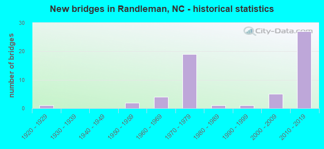
- New bridges - historical statistics
- 11920-1929
- 21950-1959
- 41960-1969
- 191970-1979
- 11980-1989
- 11990-1999
- 52000-2009
- 272010-2019
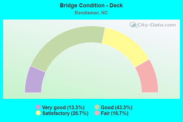
- Bridge Condition - Deck
- 13.3%Very good
- 43.3%Good
- 26.7%Satisfactory
- 16.7%Fair
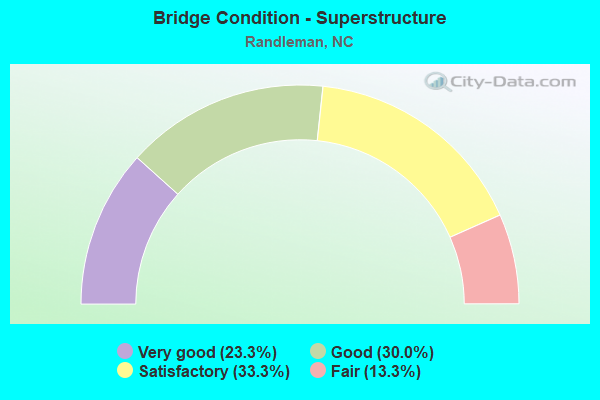
- Bridge Condition - Superstructure
- 23.3%Very good
- 30.0%Good
- 33.3%Satisfactory
- 13.3%Fair
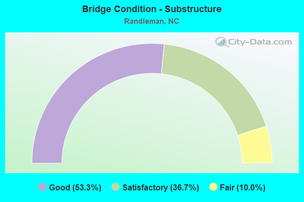
- Bridge Condition - Substructure
- 53.3%Good
- 36.7%Satisfactory
- 10.0%Fair
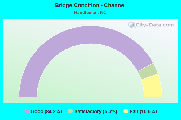
- Bridge Condition - Channel
- 84.2%Good
- 5.3%Satisfactory
- 10.5%Fair
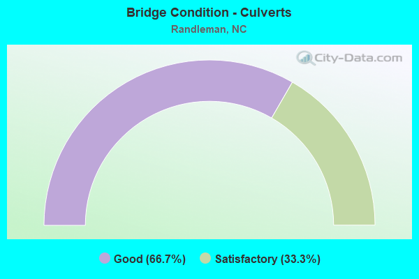
- Bridge Condition - Culverts
- 66.7%Good
- 33.3%Satisfactory
Find on map >> Show street view
Structure Number: 1510531, Location: 0.6 MI. S. JCT. I73 (Lat: 35.796333, Lng: -79.836950), Route carried "under" structure: Interstate 74, Year Built: 2011, Structure Length: 0. m, Average Daily Traffic: 7,000 (year 2015), Truck Traffic: 16%, Features Intersected: SR1511
Minimum Vertical Clearance: 5.38m (17.65ft), Kilometerpoint: 26.243, Lanes on structure: 2, Lanes under structure: 2, Material/Design: Prestressed concrete continuous, Design/Construction: Stringer/Multi-beam, Length of Maximum Span: 30.1m (98.8ft)
Find on map >> Show street view
Structure Number: 1510531, Location: 0.6 MI. S. JCT. I73 (Lat: 35.796333, Lng: -79.836950), Route carried "under" structure: Interstate 74, Year Built: 2011, Structure Length: 0. m, Average Daily Traffic: 7,000 (year 2015), Truck Traffic: 16%, Features Intersected: SR1511
Minimum Vertical Clearance: 6.50m (21.33ft), Kilometerpoint: 26.243, Lanes on structure: 2, Lanes under structure: 2, Material/Design: Prestressed concrete continuous, Design/Construction: Stringer/Multi-beam, Length of Maximum Span: 30.1m (98.8ft)
Find on map >> Show street view
Structure Number: 1510532, Location: 0.3 MI. W. JCT. I73,US220 (Lat: 35.791867, Lng: -79.829133), Route carried "under" structure: Ramp Interstate 73, Year Built: 2013, Structure Length: 0. m, Average Daily Traffic: 8,500 (year 2019), Truck Traffic: 16%, Features Intersected: I74 E. RAMP,SR9002
Minimum Vertical Clearance: 5.58m (18.31ft), Kilometerpoint: 26.030, Lanes on structure: 1, Lanes under structure: 2, Material/Design: Prestressed concrete, Design/Construction: Stringer/Multi-beam, Length of Maximum Span: 42.3m (138.8ft)
Find on map >> Show street view
Structure Number: 1510533, Location: 0.1 MI. W. JCT. I73,US220 (Lat: 35.791067, Lng: -79.826633), Route carried "under" structure: Ramp Interstate 73, Year Built: 2013, Structure Length: 0. m, Average Daily Traffic: 13,750 (year 2019), Truck Traffic: 16%, Features Intersected: I73 E. RAMP,SR9002
Minimum Vertical Clearance: 6.75m (22.15ft), Kilometerpoint: 24.475, Lanes on structure: 1, Lanes under structure: 2, Material/Design: Prestressed concrete continuous, Design/Construction: Stringer/Multi-beam, Length of Maximum Span: 32.0m (105.0ft)
Find on map >> Show street view
Structure Number: 1510533, Location: 0.1 MI. W. JCT. I73,US220 (Lat: 35.791067, Lng: -79.826633), Route carried "under" structure: Ramp Interstate 73, Year Built: 2013, Structure Length: 0. m, Average Daily Traffic: 13,750 (year 2019), Truck Traffic: 16%, Features Intersected: I73 E. RAMP,SR9002
Minimum Vertical Clearance: 6.01m (19.72ft), Kilometerpoint: 24.384, Lanes on structure: 1, Lanes under structure: 3, Material/Design: Prestressed concrete continuous, Design/Construction: Stringer/Multi-beam, Length of Maximum Span: 32.0m (105.0ft)
Find on map >> Show street view
Structure Number: 1510534, Location: 0.2 MI. W. JCT. I73 NBL (Lat: 35.788450, Lng: -79.826550), Route carried "under" structure: Interstate 73, Year Built: 2013, Structure Length: 0. m, Average Daily Traffic: 19,000 (year 2015), Truck Traffic: 16%, Features Intersected: I74 WBL
Minimum Vertical Clearance: 5.63m (18.47ft), Kilometerpoint: 24.445, Lanes on structure: 2, Lanes under structure: 2, Material/Design: Prestressed concrete continuous, Design/Construction: Stringer/Multi-beam, Length of Maximum Span: 42.3m (138.8ft)
Find on map >> Show street view
Structure Number: 1510534, Location: 0.2 MI. W. JCT. I73 NBL (Lat: 35.788450, Lng: -79.826550), Route carried "under" structure: Interstate 73, Year Built: 2013, Structure Length: 0. m, Average Daily Traffic: 19,000 (year 2015), Truck Traffic: 16%, Features Intersected: I74 WBL
Minimum Vertical Clearance: 5.56m (18.24ft), Kilometerpoint: 24.445, Lanes on structure: 2, Lanes under structure: 2, Material/Design: Prestressed concrete continuous, Design/Construction: Stringer/Multi-beam, Length of Maximum Span: 42.3m (138.8ft)