Bridge Statistics for Reston, Virginia (VA)
Condition, Traffic, Stress, Structural Evaluation, Project Costs
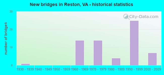
- New bridges - historical statistics
- 11930-1939
- 141960-1969
- 141970-1979
- 41980-1989
- 251990-1999
- 72000-2009
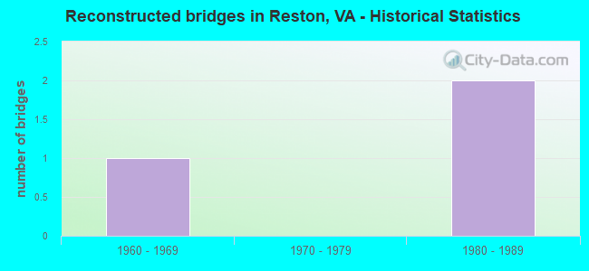
- Reconstructed bridges - Historical Statistics
- 11960-1969
- 01970-1979
- 21980-1989
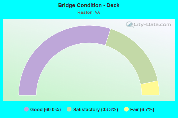
- Bridge Condition - Deck
- 60.0%Good
- 33.3%Satisfactory
- 6.7%Fair
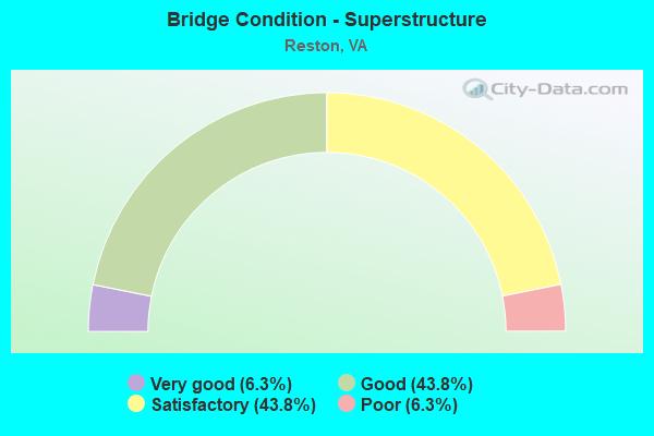
- Bridge Condition - Superstructure
- 6.3%Very good
- 43.8%Good
- 43.8%Satisfactory
- 6.3%Poor
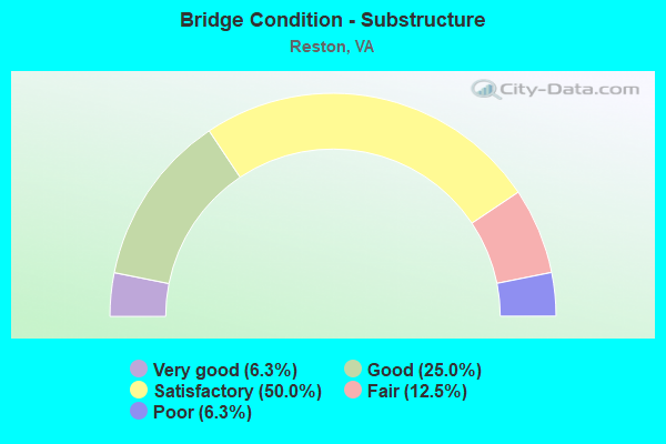
- Bridge Condition - Substructure
- 6.3%Very good
- 25.0%Good
- 50.0%Satisfactory
- 12.5%Fair
- 6.3%Poor
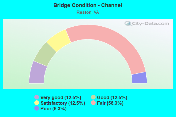
- Bridge Condition - Channel
- 12.5%Very good
- 12.5%Good
- 12.5%Satisfactory
- 56.3%Fair
- 6.3%Poor
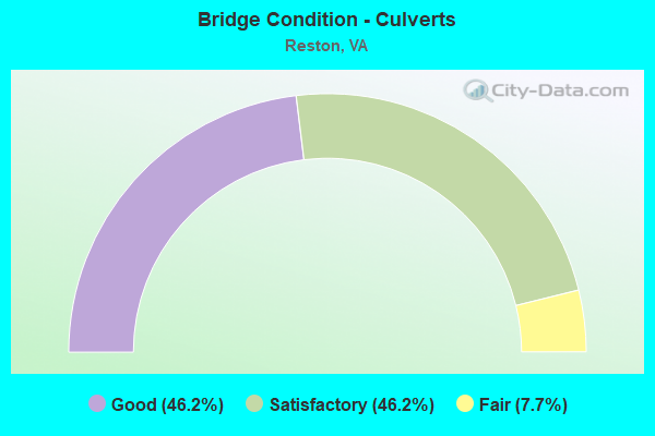
- Bridge Condition - Culverts
- 46.2%Good
- 46.2%Satisfactory
- 7.7%Fair
Find on map >> Show street view
Structure Number: 6241, Location: 00.85FR717/00.26TO606 (Lat: 38.979939, Lng: -77.319022), Route carried "on" structure: State highway 7, Year Built: 1932, Year Reconstructed: 1968, Status: Open, Structure Length: 0.64m (2.10ft), Average Daily Traffic: 55,479 (year 2020), Truck Traffic: 3%, Average Future Daily Traffic: 56,634 (year 2040), Design Load: HS 20, Features Intersected: PINEY RUN, Facility Carried by Structure: LEESBURG PIKE
Minimum Vertical Clearance: 30+ m (98+ ft), Kilometerpoint: 85.851, Lanes on structure: 4, Base Highway Network: Yes, Owner: State Highway Agency, Approaching Roadway Width: 15.2m (49.9ft), Material/Design: Concrete, Design/Construction: Culvert, Number Of Spans In Main Unit: 2, Length of Maximum Span: 3.0m (9.8ft)
Condition: Channel: Fair, Culverts: Fair, Operating Rating: 89.8 metric tons, Method Used To Determine Operating Rating: Load Factor (LF), Inventory Rating: 89.8 metric tons, Method Used To Determine Inventory Rating: Load Factor (LF), Structural Evaluation: Somewhat better than minimum adequacy, Waterway Adequacy: Better than present minimum criteria, Approach Roadway Alignment: Equal to present desirable criteria, Length Of Structure Improvement: 1.52m (4.99ft), Designated Inspection Frequency: Every 24 months, Inspection Date: July 2020, Bridge Improvement Cost: $150,000, Roadway Improvement Cost: $10,000, Total Project Cost: $170,000 ( Estimate for 2014)
Find on map >> Show street view
Structure Number: 6653, Location: 00.20FR675/00.45TO5320 (Lat: 38.952811, Lng: -77.356219), Route carried "on" structure: County highway 602, Year Built: 1977, Status: Open, Structure Length: 11.70m (38.39ft), Average Daily Traffic: 20,359 (year 2020), Truck Traffic: 1%, Average Future Daily Traffic: 22,395 (year 2040), Design Load: HS 20, Features Intersected: RTE.267 & DULLES ACC.RD., Facility Carried by Structure: RESTON PARKWAY SBL
Minimum Vertical Clearance: 30+ m (98+ ft), Kilometerpoint: 5.216, Lanes on structure: 3, Lanes under structure: 13, Owner: State Highway Agency, Approaching Roadway Width: 12.5m (41.0ft), Skew: 20 degrees, Material/Design: Steel, Design/Construction: Stringer/Multi-beam, Number Of Spans In Main Unit: 6, Length of Maximum Span: 21.6m (70.9ft), Curb or Sidewalk Widths: Left: 2.6m (8.5ft), Right: 0.0m, Curb-To-Curb Width: 11.9m (39.0ft), Out-to-Out Width: 15.8m (51.8ft)
Condition: Deck: Satisfactory, Superstructure: Good, Substructure: Satisfactory, Operating Rating: 88.0 metric tons, Method Used To Determine Operating Rating: Load and Resistance Factor (LRFR), Inventory Rating: 67.1 metric tons, Method Used To Determine Inventory Rating: Load and Resistance Factor (LRFR), Structural Evaluation: Equal to present minimum criteria, Deck Geometry: High priority of corrective action, Underclear: High priority of corrective action, Approach Roadway Alignment: Equal to present minimum criteria, Length Of Structure Improvement: 11.70m (38.39ft), Designated Inspection Frequency: Every 24 months, Inspection Date: December 2020, Bridge Improvement Cost: $10,000, Roadway Improvement Cost: $4,000, Total Project Cost: $15,000 ( Estimate for 2014), Deck Structure Type: Concrete Cast-file-Place, Wearing Surface/Protective System: Deck Protection: Epoxy Coated Reinforcing
Find on map >> Show street view
Structure Number: 6821, Location: 00.61FR665 / 00.84TO675 (Lat: 38.952736, Lng: -77.388764), Route carried "on" structure: County highway 666, Year Built: 1963, Status: Open, Structure Length: 11.70m (38.39ft), Average Daily Traffic: 8,111 (year 2020), Truck Traffic: 1%, Average Future Daily Traffic: 11,355 (year 2040), Design Load: HS 20, Features Intersected: RTE 267 & DAR, Facility Carried by Structure: MONROE ST.
Minimum Vertical Clearance: 30+ m (98+ ft), Kilometerpoint: 2.832, Lanes on structure: 2, Lanes under structure: 12, Owner: State Highway Agency, Approaching Roadway Width: 8.2m (26.9ft), Material/Design: Steel, Design/Construction: Stringer/Multi-beam, Number Of Spans In Main Unit: 6, Length of Maximum Span: 21.6m (70.9ft), Curb-To-Curb Width: 7.3m (24.0ft), Out-to-Out Width: 8.9m (29.2ft)
Condition: Deck: Good, Superstructure: Satisfactory, Substructure: Fair, Operating Rating: 79.8 metric tons, Method Used To Determine Operating Rating: Load and Resistance Factor (LRFR), Inventory Rating: 61.7 metric tons, Method Used To Determine Inventory Rating: Load and Resistance Factor (LRFR), Structural Evaluation: Somewhat better than minimum adequacy, Deck Geometry: High priority of replacement, Underclear: High priority of corrective action, Approach Roadway Alignment: Better than present minimum criteria, Length Of Structure Improvement: 11.70m (38.39ft), Designated Inspection Frequency: Every 24 months, Inspection Date: October 2021, Bridge Improvement Cost: $2,281,000, Roadway Improvement Cost: $228,000, Total Project Cost: $2,609,000, Deck Structure Type: Concrete Cast-file-Place, Wearing Surface/Protective System: Wearing Surface: Latex Concrete
Find on map >> Show street view
Structure Number: 6829, Location: 0.80FR606/0.40TO6942 (Lat: 38.965503, Lng: -77.309583), Route carried "on" structure: County highway 674, Year Built: 1974, Status: Posted for load, Structure Length: 0.91m (2.99ft), Average Daily Traffic: 6,336 (year 2020), Truck Traffic: 1%, Average Future Daily Traffic: 7,968 (year 2040), Design Load: HS 20, Features Intersected: COLVIN RUN, Facility Carried by Structure: HUNTER MILL RD.
Minimum Vertical Clearance: 30+ m (98+ ft), Kilometerpoint: 10.796, Lanes on structure: 1, Owner: State Highway Agency, Approaching Roadway Width: 5.8m (19.0ft), Material/Design: Steel, Design/Construction: Stringer/Multi-beam, Number Of Spans In Main Unit: 1, Length of Maximum Span: 8.5m (27.9ft), Curb or Sidewalk Widths: Left: 0.2m (0.7ft), Right: 0.2m (0.7ft), Curb-To-Curb Width: 4.9m (16.1ft), Out-to-Out Width: 5.5m (18.0ft)
Condition: Deck: Fair, Superstructure: Poor, Substructure: Poor, Channel: Poor, Operating Rating: 21.7 metric tons, Method Used To Determine Operating Rating: Load Testing, Inventory Rating: 16.7 metric tons, Method Used To Determine Inventory Rating: Load Testing, Structural Evaluation: Meets minimum limits, Deck Geometry: High priority of replacement, Waterway Adequacy: Equal to present minimum criteria, Approach Roadway Alignment: Better than present minimum criteria, Bridge Posting: Required (Relationship of Operating Rating to Maximum Legal Load: > 39.9% below), Length Of Structure Improvement: 1.52m (4.99ft), Designated Inspection Frequency: Every 12 months, Other Special Inspection Frequency: Every 6 months, Inspection Date: March 2021, Other Special Inspection Date: September 2021, Bridge Improvement Cost: $900,000, Roadway Improvement Cost: $50,000, Total Project Cost: $980,000 ( Estimate for 2014), Deck Structure Type: Wood or Timber, Wearing Surface/Protective System: Wearing Surface: Bituminous
Find on map >> Show street view
Structure Number: 6906, Location: 00.11 4726 / 00.34 5339 (Lat: 38.956667, Lng: -77.334753), Route carried "on" structure: County highway 828, Year Built: 1969, Status: Open, Structure Length: 0.85m (2.79ft), Average Daily Traffic: 14,602 (year 2020), Truck Traffic: 2%, Average Future Daily Traffic: 16,266 (year 2040), Design Load: HS 20, Features Intersected: COLVIN RUN, Facility Carried by Structure: WIEHLE AVENUE
Minimum Vertical Clearance: 30+ m (98+ ft), Kilometerpoint: 1.360, Lanes on structure: 4, Owner: State Highway Agency, Approaching Roadway Width: 6.7m (22.0ft), Skew: 1 degrees, Material/Design: Concrete, Design/Construction: Culvert, Number Of Spans In Main Unit: 3, Length of Maximum Span: 2.7m (8.9ft)
Condition: Channel: Fair, Culverts: Satisfactory, Operating Rating: 89.8 metric tons, Method Used To Determine Operating Rating: Load Factor (LF), Inventory Rating: 89.8 metric tons, Method Used To Determine Inventory Rating: Load Factor (LF), Structural Evaluation: Equal to present minimum criteria, Waterway Adequacy: Somewhat better than minimum adequacy, Approach Roadway Alignment: Better than present minimum criteria, Length Of Structure Improvement: 13.69m (44.91ft), Designated Inspection Frequency: Every 24 months, Inspection Date: July 2020, Bridge Improvement Cost: $35,000, Roadway Improvement Cost: $44,000, Total Project Cost: $100,000
Find on map >> Show street view
Structure Number: 6907, Location: 00.12FR5320/00.18TO675 (Lat: 38.946444, Lng: -77.337894), Route carried "on" structure: County highway 828, Year Built: 1978, Status: Open, Structure Length: 11.64m (38.19ft), Average Daily Traffic: 24,292 (year 2020), Truck Traffic: 2%, Average Future Daily Traffic: 34,009 (year 2040), Design Load: HS 20, Features Intersected: ROUTE 267 & DAAR & METRO, Facility Carried by Structure: WIEHLE AVENUE
Minimum Vertical Clearance: 30+ m (98+ ft), Kilometerpoint: 0.209, Lanes on structure: 10, Lanes under structure: 12, Owner: State Highway Agency, Approaching Roadway Width: 36.0m (118.1ft), Material/Design: Steel, Design/Construction: Stringer/Multi-beam, Number Of Spans In Main Unit: 6, Length of Maximum Span: 21.9m (71.9ft), Curb or Sidewalk Widths: Left: 2.4m (7.9ft), Right: 0.0m, Curb-To-Curb Width: 39.2m (128.6ft), Out-to-Out Width: 42.6m (139.8ft)
Condition: Deck: Satisfactory, Superstructure: Satisfactory, Substructure: Fair, Operating Rating: 58.1 metric tons, Method Used To Determine Operating Rating: Load and Resistance Factor (LRFR), Inventory Rating: 44.5 metric tons, Method Used To Determine Inventory Rating: Load and Resistance Factor (LRFR), Structural Evaluation: Somewhat better than minimum adequacy, Deck Geometry: Somewhat better than minimum adequacy, Underclear: Meets minimum limits, Approach Roadway Alignment: Better than present minimum criteria, Designated Inspection Frequency: Every 24 months, Inspection Date: May 2021, Deck Structure Type: Concrete Cast-file-Place, Wearing Surface/Protective System: Deck Protection: Epoxy Coated Reinforcing
Find on map >> Show street view
Structure Number: 7009, Location: 00.32FR4721/00.32TO5329 (Lat: 38.930064, Lng: -77.345464), Route carried "on" structure: County highway 4720, Year Built: 1977, Status: Open, Structure Length: 0.73m (2.40ft), Average Daily Traffic: 5,187 (year 2020), Average Future Daily Traffic: 7,262 (year 2040), Design Load: HS 20, Features Intersected: SNAKEDEN BRANCH, Facility Carried by Structure: SOAPSTONE DRIVE
Minimum Vertical Clearance: 30+ m (98+ ft), Kilometerpoint: 2.294, Lanes on structure: 4, Owner: State Highway Agency, Approaching Roadway Width: 15.2m (49.9ft), Skew: 3 degrees, Material/Design: Concrete, Design/Construction: Culvert, Number Of Spans In Main Unit: 3, Length of Maximum Span: 2.4m (7.9ft)
Condition: Channel: Fair, Culverts: Satisfactory, Operating Rating: 89.8 metric tons, Method Used To Determine Operating Rating: Load Factor (LF), Inventory Rating: 60.8 metric tons, Method Used To Determine Inventory Rating: Load Factor (LF), Structural Evaluation: Equal to present minimum criteria, Waterway Adequacy: Equal to present minimum criteria, Approach Roadway Alignment: Equal to present minimum criteria, Length Of Structure Improvement: 0.30m (0.98ft), Designated Inspection Frequency: Every 24 months, Inspection Date: September 2020, Bridge Improvement Cost: $1,000, Roadway Improvement Cost: $1,000, Total Project Cost: $3,000 ( Estimate for 2014)
Find on map >> Show street view
Structure Number: 7011, Location: 00.07FR4790/00.15TO673 (Lat: 38.922647, Lng: -77.345378), Route carried "on" structure: County highway 4720, Year Built: 1969, Status: Open, Structure Length: 0.67m (2.20ft), Average Daily Traffic: 3,702 (year 2020), Truck Traffic: 3%, Average Future Daily Traffic: 5,115 (year 2040), Design Load: HS 20, Features Intersected: THE GLADE, Facility Carried by Structure: SOAPSTONE DRIVE
Minimum Vertical Clearance: 30+ m (98+ ft), Kilometerpoint: 1.426, Lanes on structure: 2, Owner: State Highway Agency, Approaching Roadway Width: 11.0m (36.1ft), Material/Design: Concrete, Design/Construction: Culvert, Number Of Spans In Main Unit: 3, Length of Maximum Span: 2.1m (6.9ft)
Condition: Channel: Fair, Culverts: Satisfactory, Operating Rating: 89.8 metric tons, Method Used To Determine Operating Rating: Load Factor (LF), Inventory Rating: 57.2 metric tons, Method Used To Determine Inventory Rating: Load Factor (LF), Structural Evaluation: Equal to present minimum criteria, Waterway Adequacy: Better than present minimum criteria, Approach Roadway Alignment: Better than present minimum criteria, Length Of Structure Improvement: 5.76m (18.90ft), Designated Inspection Frequency: Every 24 months, Inspection Date: June 2020, Bridge Improvement Cost: $35,000, Roadway Improvement Cost: $55,000, Total Project Cost: $100,000
Find on map >> Show street view
Structure Number: 702, Location: 00.26FR4725/00.22TO4727 (Lat: 38.967608, Lng: -77.343308), Route carried "on" structure: County highway 4726, Year Built: 1973, Status: Open, Structure Length: 1.19m (3.90ft), Average Daily Traffic: 3,533 (year 2020), Truck Traffic: 3%, Average Future Daily Traffic: 3,953 (year 2040), Design Load: HS 20, Features Intersected: TRIBUTARY TO LAKE ANNE, Facility Carried by Structure: NORTH SHORE DRIVE
Minimum Vertical Clearance: 30+ m (98+ ft), Kilometerpoint: 3.942, Lanes on structure: 2, Owner: State Highway Agency, Approaching Roadway Width: 13.4m (44.0ft), Material/Design: Prestressed concrete, Design/Construction: Slab, Number Of Spans In Main Unit: 1, Length of Maximum Span: 11.9m (39.0ft), Curb or Sidewalk Widths: Left: 0.4m (1.3ft), Right: 0.4m (1.3ft), Curb-To-Curb Width: 13.4m (44.0ft), Out-to-Out Width: 14.5m (47.6ft)
Condition: Deck: Good, Superstructure: Good, Substructure: Satisfactory, Channel: Very good, Operating Rating: 57.2 metric tons, Method Used To Determine Operating Rating: Load and Resistance Factor (LRFR), Inventory Rating: 44.2 metric tons, Method Used To Determine Inventory Rating: Load and Resistance Factor (LRFR), Structural Evaluation: Equal to present minimum criteria, Deck Geometry: Better than present minimum criteria, Waterway Adequacy: Equal to present desirable criteria, Approach Roadway Alignment: Better than present minimum criteria, Length Of Structure Improvement: 0.30m (0.98ft), Designated Inspection Frequency: Every 24 months, Inspection Date: Febuary 2022, Bridge Improvement Cost: $1,000, Roadway Improvement Cost: $1,000, Total Project Cost: $3,000, Deck Structure Type: Concrete Cast-file-Place, Wearing Surface/Protective System: Wearing Surface: Bituminous
Find on map >> Show street view
Structure Number: 7044, Location: 00.05 4721 / 00.30 673 (Lat: 38.931122, Lng: -77.324464), Route carried "on" structure: County highway 5301, Year Built: 1989, Status: Open, Structure Length: 0.91m (2.99ft), Average Daily Traffic: 6,540 (year 2020), Truck Traffic: 1%, Average Future Daily Traffic: 9,156 (year 2040), Design Load: HS 20, Features Intersected: THE GLADE, Facility Carried by Structure: TWIN BRANCHES ROAD
Minimum Vertical Clearance: 30+ m (98+ ft), Kilometerpoint: 0.451, Lanes on structure: 2, Owner: State Highway Agency, Approaching Roadway Width: 13.4m (44.0ft), Skew: 3 degrees, Material/Design: Steel, Design/Construction: Culvert, Number Of Spans In Main Unit: 2, Length of Maximum Span: 3.0m (9.8ft)
Condition: Channel: Satisfactory, Culverts: Satisfactory, Operating Rating: 44.5 metric tons, Method Used To Determine Operating Rating: Load Factor (LF), Inventory Rating: 32.7 metric tons, Method Used To Determine Inventory Rating: Load Factor (LF), Structural Evaluation: Equal to present minimum criteria, Waterway Adequacy: Better than present minimum criteria, Approach Roadway Alignment: Better than present minimum criteria, Length Of Structure Improvement: 21.09m (69.19ft), Designated Inspection Frequency: Every 24 months, Inspection Date: January 2022, Bridge Improvement Cost: $10,000, Roadway Improvement Cost: $10,000, Total Project Cost: $30,000
Find on map >> Show street view
Structure Number: 7046, Location: 00.15FR7100/00.15TO4721 (Lat: 38.948144, Lng: -77.376239), Route carried "on" structure: County highway 5320, Year Built: 1991, Status: Open, Structure Length: 1.28m (4.20ft), Average Daily Traffic: 11,291 (year 2020), Truck Traffic: 2%, Average Future Daily Traffic: 12,420 (year 2040), Design Load: HS 20+Mod, Features Intersected: TRIBUTARY SUGARLAND RUN, Facility Carried by Structure: SUNRISE VALLEY DR.
Minimum Vertical Clearance: 30+ m (98+ ft), Kilometerpoint: 2.843, Lanes on structure: 6, Owner: State Highway Agency, Approaching Roadway Width: 25.6m (84.0ft), Material/Design: Concrete, Design/Construction: Culvert, Number Of Spans In Main Unit: 4, Length of Maximum Span: 3.0m (9.8ft)
Condition: Channel: Fair, Culverts: Good, Operating Rating: 89.8 metric tons, Method Used To Determine Operating Rating: Load Factor (LF), Inventory Rating: 61.7 metric tons, Method Used To Determine Inventory Rating: Load Factor (LF), Structural Evaluation: Better than present minimum criteria, Waterway Adequacy: Equal to present minimum criteria, Approach Roadway Alignment: Better than present minimum criteria, Length Of Structure Improvement: 4.85m (15.91ft), Designated Inspection Frequency: Every 24 months, Inspection Date: May 2020, Bridge Improvement Cost: $23,000, Roadway Improvement Cost: $44,000, Total Project Cost: $120,000
Find on map >> Show street view
Structure Number: 23034, Location: 00.15FR602 / 00.30TO7410 (Lat: 38.984361, Lng: -77.339611), Route carried "on" structure: County highway 828, Year Built: 1991, Status: Open, Structure Length: 1.97m (6.46ft), Average Daily Traffic: 10,234 (year 2020), Truck Traffic: 2%, Average Future Daily Traffic: 14,328 (year 2040), Design Load: HS 20, Features Intersected: HIKE & BIKE TRAIL, Facility Carried by Structure: WIEHLE AVENUE
Minimum Vertical Clearance: 30+ m (98+ ft), Kilometerpoint: 4.682, Lanes on structure: 6, Owner: State Highway Agency, Approaching Roadway Width: 15.2m (49.9ft), Skew: 20 degrees, Material/Design: Steel, Design/Construction: Stringer/Multi-beam, Number Of Spans In Main Unit: 1, Length of Maximum Span: 19.2m (63.0ft), Curb or Sidewalk Widths: Left: 0.2m (0.7ft), Right: 2.4m (7.9ft), Curb-To-Curb Width: 23.2m (76.1ft), Out-to-Out Width: 28.7m (94.2ft)
Condition: Deck: Good, Superstructure: Satisfactory, Substructure: Satisfactory, Operating Rating: 89.8 metric tons, Method Used To Determine Operating Rating: Load and Resistance Factor (LRFR), Inventory Rating: 79.8 metric tons, Method Used To Determine Inventory Rating: Load and Resistance Factor (LRFR), Structural Evaluation: Equal to present minimum criteria, Deck Geometry: Meets minimum limits, Approach Roadway Alignment: Equal to present desirable criteria, Designated Inspection Frequency: Every 24 months, Inspection Date: July 2021, Deck Structure Type: Concrete Cast-file-Place, Wearing Surface/Protective System: Deck Protection: Epoxy Coated Reinforcing
Find on map >> Show street view
Structure Number: 2312, Location: 00.02FR5320/ 00.30TO267 (Lat: 38.948836, Lng: -77.376528), Route carried "on" structure: County highway 286, Year Built: 1991, Status: Open, Structure Length: 1.55m (5.09ft), Average Daily Traffic: 40,785 (year 2020), Truck Traffic: 1%, Average Future Daily Traffic: 57,099 (year 2040), Design Load: HS 20+Mod, Features Intersected: SUGARLAND RUN, Facility Carried by Structure: FAIRFAX CO. PKWY.
Minimum Vertical Clearance: 30+ m (98+ ft), Kilometerpoint: 0.000, Lanes on structure: 4, Base Highway Network: Yes, Owner: State Highway Agency, Approaching Roadway Width: 20.7m (67.9ft), Skew: 3 degrees, Material/Design: Concrete, Design/Construction: Culvert, Number Of Spans In Main Unit: 4, Length of Maximum Span: 3.0m (9.8ft), Curb-To-Curb Width: 20.4m (66.9ft), Out-to-Out Width: 25.9m (85.0ft)
Condition: Channel: Satisfactory, Culverts: Satisfactory, Operating Rating: 89.8 metric tons, Method Used To Determine Operating Rating: Load Factor (LF), Inventory Rating: 61.7 metric tons, Method Used To Determine Inventory Rating: Load Factor (LF), Structural Evaluation: Equal to present minimum criteria, Deck Geometry: Superior to present desirable criteria, Waterway Adequacy: Equal to present desirable criteria, Approach Roadway Alignment: Equal to present desirable criteria, Length Of Structure Improvement: 47.24m (154.99ft), Designated Inspection Frequency: Every 24 months, Inspection Date: May 2020, Bridge Improvement Cost: $50,000, Roadway Improvement Cost: $125,000, Total Project Cost: $200,000
Find on map >> Show street view
Structure Number: 23121, Location: 00.32 5320 / 00.23 675 (Lat: 38.952700, Lng: -77.374300), Route carried "on" structure: Bypass State highway 286, Year Built: 1991, Status: Open, Structure Length: 11.70m (38.39ft), Average Daily Traffic: 49,192 (year 2020), Truck Traffic: 1%, Average Future Daily Traffic: 68,869 (year 2040), Design Load: HS 20, Features Intersected: DAR & ROUTE 267, Facility Carried by Structure: FAIRFAX CO. PKWY.
Minimum Vertical Clearance: 30+ m (98+ ft), Kilometerpoint: 0.000, Lanes on structure: 8, Lanes under structure: 12, Base Highway Network: Yes, Owner: State Highway Agency, Approaching Roadway Width: 37.2m (122.0ft), Skew: 23 degrees, Material/Design: Steel continuous, Design/Construction: Stringer/Multi-beam, Number Of Spans In Main Unit: 4, Length of Maximum Span: 31.7m (104.0ft), Curb or Sidewalk Widths: Left: 0.0m, Right: 3.4m (11.2ft), Curb-To-Curb Width: 29.9m (98.1ft), Out-to-Out Width: 42.6m (139.8ft)
Condition: Deck: Satisfactory, Superstructure: Good, Substructure: Satisfactory, Operating Rating: 76.2 metric tons, Method Used To Determine Operating Rating: Load and Resistance Factor (LRFR), Inventory Rating: 56.2 metric tons, Method Used To Determine Inventory Rating: Load and Resistance Factor (LRFR), Structural Evaluation: Equal to present minimum criteria, Deck Geometry: Meets minimum limits, Underclear: High priority of corrective action, Approach Roadway Alignment: Equal to present desirable criteria, Length Of Structure Improvement: 11.70m (38.39ft), Designated Inspection Frequency: Every 24 months, Inspection Date: October 2021, Bridge Improvement Cost: $79,000, Roadway Improvement Cost: $450,000, Total Project Cost: $600,000, Deck Structure Type: Concrete Cast-file-Place, Wearing Surface/Protective System: Wearing Surface: Monolithic Concrete, Deck Protection: Epoxy Coated Reinforcing
Find on map >> Show street view
Structure Number: 23479, Location: 00.15FR606/01.05TO602 (Lat: 38.957417, Lng: -77.371972), Route carried "on" structure: County highway 675, Year Built: 1992, Status: Open, Structure Length: 1.22m (4.00ft), Average Daily Traffic: 12,636 (year 2014), Truck Traffic: 1%, Average Future Daily Traffic: 22,613 (year 2035), Design Load: HS 20, Features Intersected: Sugarland Run, Facility Carried by Structure: Spring St.
Minimum Vertical Clearance: 30+ m (98+ ft), Kilometerpoint: 0.000, Lanes on structure: 4, Owner: State Highway Agency, Approaching Roadway Width: 9.8m (32.2ft), Material/Design: Concrete, Design/Construction: Culvert, Number Of Spans In Main Unit: 1, Length of Maximum Span: 3.0m (9.8ft), Out-to-Out Width: 13.7m (44.9ft)
Condition: Channel: Fair, Culverts: Good, Operating Rating: 69.9 metric tons, Method Used To Determine Operating Rating: Load Factor (LF), Inventory Rating: 41.7 metric tons, Method Used To Determine Inventory Rating: Load Factor (LF), Structural Evaluation: Better than present minimum criteria, Waterway Adequacy: Equal to present desirable criteria, Approach Roadway Alignment: Better than present minimum criteria, Length Of Structure Improvement: 0.30m (0.98ft), Designated Inspection Frequency: Every 24 months, Inspection Date: August 2021, Bridge Improvement Cost: $1,000, Roadway Improvement Cost: $1,000, Total Project Cost: $3,000
Find on map >> Show street view
Structure Number: 23493, Location: 00.32FR.267/00.68TO606 (Lat: 38.957083, Lng: -77.371108), Route carried "on" structure: County highway 286, Year Built: 1993, Status: Open, Structure Length: 3.57m (11.71ft), Average Daily Traffic: 49,192 (year 2020), Truck Traffic: 1%, Average Future Daily Traffic: 68,869 (year 2040), Design Load: HS 20, Features Intersected: SPRING STREET, Facility Carried by Structure: FAIRFAX CO. PKWY.
Minimum Vertical Clearance: 30+ m (98+ ft), Kilometerpoint: 0.000, Lanes on structure: 9, Lanes under structure: 5, Base Highway Network: Yes, Owner: State Highway Agency, Approaching Roadway Width: 45.7m (149.9ft), Skew: 21 degrees, Material/Design: Steel, Design/Construction: Stringer/Multi-beam, Number Of Spans In Main Unit: 1, Length of Maximum Span: 34.7m (113.8ft), Curb or Sidewalk Widths: Left: 0.0m, Right: 3.0m (9.8ft), Curb-To-Curb Width: 41.6m (136.5ft), Out-to-Out Width: 45.8m (150.3ft)
Condition: Deck: Good, Superstructure: Good, Substructure: Good, Operating Rating: 55.3 metric tons, Method Used To Determine Operating Rating: Load and Resistance Factor (LRFR), Inventory Rating: 42.6 metric tons, Method Used To Determine Inventory Rating: Load and Resistance Factor (LRFR), Structural Evaluation: Better than present minimum criteria, Deck Geometry: Superior to present desirable criteria, Underclear: Somewhat better than minimum adequacy, Approach Roadway Alignment: Equal to present desirable criteria, Length Of Structure Improvement: 0.30m (0.98ft), Designated Inspection Frequency: Every 24 months, Inspection Date: July 2021, Bridge Improvement Cost: $40,000, Roadway Improvement Cost: $5,000, Total Project Cost: $50,000, Deck Structure Type: Concrete Cast-file-Place, Wearing Surface/Protective System: Wearing Surface: Monolithic Concrete, Deck Protection: Epoxy Coated Reinforcing
Find on map >> Show street view
Structure Number: 25075, Location: .25 mi.Fr267/.10mi.To Lot (Lat: 38.951561, Lng: -77.383858), Route carried "on" structure: Ramp County highway , Year Built: 1999, Status: Open, Structure Length: 18.75m (61.52ft), Average Daily Traffic: 1,000 (year 1999), Average Future Daily Traffic: 2,000 (year 2035), Design Load: HS 20, Features Intersected: TOLL RD.267 / D.A.R., Facility Carried by Structure: Herndon/Monroe Rmp
Minimum Vertical Clearance: 30+ m (98+ ft), Kilometerpoint: 0.000, Lanes on structure: 1, Lanes under structure: 22, Owner: State Highway Agency, Approaching Roadway Width: 6.7m (22.0ft), Material/Design: Steel continuous, Design/Construction: Stringer/Multi-beam, Number Of Spans In Main Unit: 6, Number Of Approach Spans: 3, Length of Maximum Span: 33.2m (108.9ft), Curb-To-Curb Width: 9.0m (29.5ft), Out-to-Out Width: 10.0m (32.8ft)
Condition: Deck: Good, Superstructure: Good, Substructure: Good, Operating Rating: 46.6 metric tons, Method Used To Determine Operating Rating: Load and Resistance Factor (LRFR), Inventory Rating: 36.0 metric tons, Method Used To Determine Inventory Rating: Load and Resistance Factor (LRFR), Structural Evaluation: Better than present minimum criteria, Deck Geometry: Superior to present desirable criteria, Underclear: Meets minimum limits, Approach Roadway Alignment: Better than present minimum criteria, Length Of Structure Improvement: 18.75m (61.52ft), Designated Inspection Frequency: Every 24 months, Inspection Date: May 2021, Bridge Improvement Cost: $65,000, Roadway Improvement Cost: $125,000, Total Project Cost: $250,000 ( Estimate for 2015), Deck Structure Type: Concrete Cast-file-Place, Wearing Surface/Protective System: Deck Protection: Epoxy Coated Reinforcing
Find on map >> Show street view
Structure Number: 25681, Location: 00.10FR675/00.75TO606 (Lat: 38.956878, Lng: -77.354919), Route carried "on" structure: County highway 602, Year Built: 1998, Status: Open, Structure Length: 1.83m (6.00ft), Average Daily Traffic: 19,433 (year 2020), Truck Traffic: 1%, Average Future Daily Traffic: 27,206 (year 2040), Design Load: HS 20+Mod, Features Intersected: W & OD HIKE & BIKE TRAIL, Facility Carried by Structure: RESTON PARKWAY
Minimum Vertical Clearance: 30+ m (98+ ft), Kilometerpoint: 5.712, Lanes on structure: 8, Owner: State Highway Agency, Approaching Roadway Width: 29.3m (96.1ft), Skew: 10 degrees, Material/Design: Concrete, Design/Construction: Arch - Deck, Number Of Spans In Main Unit: 1, Length of Maximum Span: 18.3m (60.0ft), Curb or Sidewalk Widths: Left: 2.8m (9.2ft), Right: 2.2m (7.2ft), Curb-To-Curb Width: 29.9m (98.1ft), Out-to-Out Width: 41.1m (134.8ft)
Condition: Deck: Good, Superstructure: Good, Substructure: Very good, Operating Rating: 75.0 metric tons, Method Used To Determine Operating Rating: Load and Resistance Factor (LRFR), Inventory Rating: 59.0 metric tons, Method Used To Determine Inventory Rating: Load and Resistance Factor (LRFR), Structural Evaluation: Better than present minimum criteria, Deck Geometry: Meets minimum limits, Approach Roadway Alignment: Equal to present desirable criteria, Length Of Structure Improvement: 1.83m (6.00ft), Designated Inspection Frequency: Every 24 months, Inspection Date: December 2020, Bridge Improvement Cost: $200,000, Roadway Improvement Cost: $20,000, Total Project Cost: $250,000 ( Estimate for 2016)
Find on map >> Show street view
Structure Number: 25733, Location: 00.62FR675/02.89TO7 (Lat: 38.965692, Lng: -77.365264), Route carried "on" structure: County highway 286, Year Built: 2001, Status: Open, Structure Length: 12.59m (41.31ft), Average Daily Traffic: 49,192 (year 2020), Truck Traffic: 1%, Average Future Daily Traffic: 68,869 (year 2040), Design Load: HS 20, Features Intersected: RTE.606 BARON CAMERON AV, Facility Carried by Structure: FAIRFAX CO PKWY
Minimum Vertical Clearance: 30+ m (98+ ft), Kilometerpoint: 0.000, Lanes on structure: 6, Lanes under structure: 14, Base Highway Network: Yes, Owner: State Highway Agency, Approaching Roadway Width: 35.7m (117.1ft), Skew: 22 degrees, Material/Design: Steel continuous, Design/Construction: Stringer/Multi-beam, Number Of Spans In Main Unit: 3, Length of Maximum Span: 47.5m (155.8ft), Curb-To-Curb Width: 34.7m (113.8ft), Out-to-Out Width: 35.8m (117.5ft)
Condition: Deck: Good, Superstructure: Very good, Substructure: Good, Operating Rating: 68.9 metric tons, Method Used To Determine Operating Rating: Load and Resistance Factor (LRFR), Inventory Rating: 53.5 metric tons, Method Used To Determine Inventory Rating: Load and Resistance Factor (LRFR), Structural Evaluation: Better than present minimum criteria, Deck Geometry: Superior to present desirable criteria, Underclear: Meets minimum limits, Approach Roadway Alignment: Equal to present desirable criteria, Length Of Structure Improvement: 12.59m (41.31ft), Designated Inspection Frequency: Every 24 months, Inspection Date: May 2021, Bridge Improvement Cost: $56,000, Roadway Improvement Cost: $140,000, Total Project Cost: $200,000 ( Estimate for 2015), Deck Structure Type: Concrete Cast-file-Place, Wearing Surface/Protective System: Deck Protection: Epoxy Coated Reinforcing
Find on map >> Show street view
Structure Number: 258, Location: 00.15FR END/00.22TO0000 (Lat: 38.991683, Lng: -77.333800), Route carried "on" structure: County highway 10025, Year Built: 1998, Status: Open, Structure Length: 0.73m (2.40ft), Average Daily Traffic: 145 (year 2014), Average Future Daily Traffic: 164 (year 2040), Design Load: HS 20, Features Intersected: DOG RUN, Facility Carried by Structure: STONES THROW DRIVE
Minimum Vertical Clearance: 30+ m (98+ ft), Kilometerpoint: 0.000, Lanes on structure: 2, Owner: State Highway Agency, Approaching Roadway Width: 9.1m (29.9ft), Material/Design: Concrete, Design/Construction: Culvert, Number Of Spans In Main Unit: 3, Length of Maximum Span: 2.1m (6.9ft), Curb or Sidewalk Widths: Left: 1.8m (5.9ft), Right: 0.0m
Condition: Channel: Fair, Culverts: Good, Operating Rating: 89.8 metric tons, Method Used To Determine Operating Rating: Load Factor (LF), Inventory Rating: 60.8 metric tons, Method Used To Determine Inventory Rating: Load Factor (LF), Structural Evaluation: Better than present minimum criteria, Waterway Adequacy: Better than present minimum criteria, Approach Roadway Alignment: Equal to present desirable criteria, Length Of Structure Improvement: 0.61m (2.00ft), Designated Inspection Frequency: Every 24 months, Inspection Date: Febuary 2021, Bridge Improvement Cost: $10,000, Roadway Improvement Cost: $10,000, Total Project Cost: $25,000
Find on map >> Show street view
Structure Number: 25828, Location: 00.10FR7412/ 00.20TO7675 (Lat: 38.976400, Lng: -77.361933), Route carried "on" structure: County highway 286, Year Built: 1999, Status: Open, Structure Length: 2.10m (6.89ft), Average Daily Traffic: 20,206 (year 2020), Truck Traffic: 1%, Average Future Daily Traffic: 22,227 (year 2040), Design Load: HS 20, Features Intersected: TRIB. OF SUGARLAND RUN, Facility Carried by Structure: FAIRFAX CO. PKWY.
Minimum Vertical Clearance: 30+ m (98+ ft), Kilometerpoint: 0.000, Lanes on structure: 6, Owner: State Highway Agency, Approaching Roadway Width: 29.3m (96.1ft), Skew: 5 degrees, Material/Design: Concrete, Design/Construction: Culvert, Number Of Spans In Main Unit: 4, Length of Maximum Span: 5.2m (17.1ft)
Condition: Channel: Good, Culverts: Good, Operating Rating: 89.8 metric tons, Method Used To Determine Operating Rating: Load Factor (LF), Inventory Rating: 89.7 metric tons, Method Used To Determine Inventory Rating: Load Factor (LF), Structural Evaluation: Better than present minimum criteria, Waterway Adequacy: Equal to present desirable criteria, Approach Roadway Alignment: Equal to present desirable criteria, Length Of Structure Improvement: 0.30m (0.98ft), Designated Inspection Frequency: Every 24 months, Inspection Date: September 2021, Bridge Improvement Cost: $1,000, Roadway Improvement Cost: $1,000, Total Project Cost: $3,000
Find on map >> Show street view
Structure Number: 25829, Location: 00.01FR7100/00.22TO7420 (Lat: 38.974936, Lng: -77.361756), Route carried "on" structure: County highway 7412, Year Built: 1999, Status: Open, Structure Length: 0.82m (2.69ft), Average Daily Traffic: 1,255 (year 2020), Average Future Daily Traffic: 1,757 (year 2040), Design Load: HS 20, Features Intersected: TRIB. OF SUGARLAND RUN, Facility Carried by Structure: WALNUT BRANCH ROAD
Minimum Vertical Clearance: 30+ m (98+ ft), Kilometerpoint: 0.290, Lanes on structure: 3, Owner: State Highway Agency, Approaching Roadway Width: 11.3m (37.1ft), Skew: 2 degrees, Material/Design: Concrete, Design/Construction: Culvert, Number Of Spans In Main Unit: 3, Length of Maximum Span: 2.7m (8.9ft)
Condition: Channel: Fair, Culverts: Good, Operating Rating: 89.8 metric tons, Method Used To Determine Operating Rating: Load Factor (LF), Inventory Rating: 59.0 metric tons, Method Used To Determine Inventory Rating: Load Factor (LF), Structural Evaluation: Better than present minimum criteria, Waterway Adequacy: Equal to present minimum criteria, Approach Roadway Alignment: Equal to present desirable criteria, Length Of Structure Improvement: 9.81m (32.19ft), Designated Inspection Frequency: Every 24 months, Inspection Date: Febuary 2022, Bridge Improvement Cost: $33,000, Roadway Improvement Cost: $54,000, Total Project Cost: $100,000
Find on map >> Show street view
Structure Number: 2583, Location: 00.57FR7675 / 00.40TO828 (Lat: 38.987317, Lng: -77.359317), Route carried "on" structure: County highway 286, Year Built: 1999, Status: Open, Structure Length: 1.37m (4.49ft), Average Daily Traffic: 20,206 (year 2020), Truck Traffic: 1%, Average Future Daily Traffic: 22,227 (year 2040), Design Load: HS 20, Features Intersected: ROSIERS BRANCH, Facility Carried by Structure: FAIRFAX CO. PKWY.
Minimum Vertical Clearance: 30+ m (98+ ft), Kilometerpoint: 0.000, Lanes on structure: 6, Owner: State Highway Agency, Approaching Roadway Width: 8.5m (27.9ft), Skew: 4 degrees, Material/Design: Concrete, Design/Construction: Culvert, Number Of Spans In Main Unit: 4, Length of Maximum Span: 3.4m (11.2ft)
Condition: Channel: Fair, Culverts: Satisfactory, Operating Rating: 89.8 metric tons, Method Used To Determine Operating Rating: Load Factor (LF), Inventory Rating: 59.0 metric tons, Method Used To Determine Inventory Rating: Load Factor (LF), Structural Evaluation: Equal to present minimum criteria, Waterway Adequacy: Equal to present desirable criteria, Approach Roadway Alignment: Equal to present desirable criteria, Length Of Structure Improvement: 33.77m (110.79ft), Designated Inspection Frequency: Every 24 months, Inspection Date: August 2021, Bridge Improvement Cost: $5,000, Roadway Improvement Cost: $5,000, Total Project Cost: $15,000 ( Estimate for 2015)
Find on map >> Show street view
Structure Number: 28722, Location: 00.65FR0672/00.02TO0000 (Lat: 38.905781, Lng: -77.342878), Route carried "on" structure: County highway 10147, Year Built: 2004, Status: Open, Structure Length: 1.04m (3.41ft), Average Daily Traffic: 566 (year 2009), Average Future Daily Traffic: 654 (year 2040), Design Load: HS 20, Features Intersected: SOUTH FORK RUN, Facility Carried by Structure: MARSHALL LAKE DR.
Minimum Vertical Clearance: 30+ m (98+ ft), Kilometerpoint: 0.000, Lanes on structure: 2, Owner: State Highway Agency, Approaching Roadway Width: 10.4m (34.1ft), Material/Design: Concrete, Design/Construction: Arch - Deck, Number Of Spans In Main Unit: 1, Length of Maximum Span: 9.8m (32.2ft), Curb or Sidewalk Widths: Left: 1.8m (5.9ft), Right: 0.0m, Curb-To-Curb Width: 11.0m (36.1ft), Out-to-Out Width: 29.3m (96.1ft)
Condition: Superstructure: Good, Substructure: Good, Channel: Very good, Operating Rating: 89.8 metric tons, Method Used To Determine Operating Rating: Load Factor (LF), Inventory Rating: 89.8 metric tons, Method Used To Determine Inventory Rating: Load Factor (LF), Structural Evaluation: Better than present minimum criteria, Deck Geometry: Better than present minimum criteria, Waterway Adequacy: Equal to present desirable criteria, Approach Roadway Alignment: Equal to present desirable criteria, Length Of Structure Improvement: 0.30m (0.98ft), Designated Inspection Frequency: Every 24 months, Inspection Date: Febuary 2022, Bridge Improvement Cost: $1,000, Roadway Improvement Cost: $1,000, Total Project Cost: $3,000 ( Estimate for 2016)
Find on map >> Show street view
Structure Number: 2100009P, Location: 7.2 MILES FROM DULLES AIR (Lat: 38.944694, Lng: -77.325972), Route carried "on" structure: Other road 267, Year Built: 1963, Year Reconstructed: 1985, Status: Open, Structure Length: 5.15m (16.90ft), Average Daily Traffic: 13,000 (year 2006), Truck Traffic: 12%, Average Future Daily Traffic: 14,300 (year 2026), Design Load: HS 20, Features Intersected: W&OD TRAIL, Facility Carried by Structure: WB DULLES ACCESS R
Minimum Vertical Clearance: 30+ m (98+ ft), Kilometerpoint: 11.590, Lanes on structure: 2, Toll: On toll road, Owner: Metropolitan Washington Airports Service, Approaching Roadway Width: 11.6m (38.1ft), Skew: 3 degrees, Material/Design: Steel, Design/Construction: Stringer/Multi-beam, Number Of Spans In Main Unit: 3, Length of Maximum Span: 17.4m (57.1ft), Curb-To-Curb Width: 11.7m (38.4ft), Out-to-Out Width: 13.4m (44.0ft)
Condition: Deck: Satisfactory, Superstructure: Satisfactory, Substructure: Satisfactory, Operating Rating: 54.4 metric tons, Method Used To Determine Operating Rating: Allowable Stress (AS), Inventory Rating: 33.0 metric tons, Method Used To Determine Inventory Rating: Allowable Stress (AS), Structural Evaluation: Equal to present minimum criteria, Deck Geometry: Better than present minimum criteria, Approach Roadway Alignment: Equal to present desirable criteria, Length Of Structure Improvement: 5.33m (17.49ft), Designated Inspection Frequency: Every 24 months, Inspection Date: September 2019, Bridge Improvement Cost: $340,000, Roadway Improvement Cost: $34,000, Total Project Cost: $510,000 ( Estimate for 2017), Deck Structure Type: Concrete Cast-file-Place, Wearing Surface/Protective System: Wearing Surface: Monolithic Concrete
Find on map >> Show street view
Structure Number: 2100010P, Location: 7.2 MILES FROM DULLES AIR (Lat: 38.944472, Lng: -77.325806), Route carried "on" structure: Other road 267, Year Built: 1963, Year Reconstructed: 1985, Status: Open, Structure Length: 5.10m (16.73ft), Average Daily Traffic: 13,000 (year 2006), Truck Traffic: 12%, Average Future Daily Traffic: 14,300 (year 2026), Design Load: HS 20, Features Intersected: W&OD TRAIL, Facility Carried by Structure: EB DULLES ACCESS R
Minimum Vertical Clearance: 30+ m (98+ ft), Kilometerpoint: 11.590, Lanes on structure: 2, Toll: On toll road, Owner: Metropolitan Washington Airports Service, Approaching Roadway Width: 11.9m (39.0ft), Skew: 3 degrees, Material/Design: Steel, Design/Construction: Stringer/Multi-beam, Number Of Spans In Main Unit: 3, Length of Maximum Span: 17.3m (56.8ft), Curb-To-Curb Width: 11.6m (38.1ft), Out-to-Out Width: 13.3m (43.6ft)
Condition: Deck: Satisfactory, Superstructure: Satisfactory, Substructure: Satisfactory, Operating Rating: 54.4 metric tons, Method Used To Determine Operating Rating: Allowable Stress (AS), Inventory Rating: 33.0 metric tons, Method Used To Determine Inventory Rating: Allowable Stress (AS), Structural Evaluation: Equal to present minimum criteria, Deck Geometry: Better than present minimum criteria, Approach Roadway Alignment: Equal to present desirable criteria, Designated Inspection Frequency: Every 24 months, Inspection Date: September 2019, Bridge Improvement Cost: $450,000, Roadway Improvement Cost: $45,000, Total Project Cost: $675,000 ( Estimate for 2017), Deck Structure Type: Concrete Cast-file-Place, Wearing Surface/Protective System: Wearing Surface: Monolithic Concrete
Find on map >> Show street view
Structure Number: 2100042P, Location: 7.2 MILES FROM DULLES AIR (Lat: 38.944300, Lng: -77.325661), Route carried "on" structure: State highway 367, Year Built: 1984, Status: Open, Structure Length: 5.00m (16.40ft), Average Daily Traffic: 22,000 (year 2008), Average Future Daily Traffic: 26,400 (year 2028), Features Intersected: W&OD TRAIL, Facility Carried by Structure: EB DULLES TOLL ROA
Minimum Vertical Clearance: 30+ m (98+ ft), Kilometerpoint: 11.590, Lanes on structure: 4, Toll: On toll road, Owner: Metropolitan Washington Airports Service, Approaching Roadway Width: 17.6m (57.7ft), Skew: 3 degrees, Material/Design: Steel, Design/Construction: Stringer/Multi-beam, Number Of Spans In Main Unit: 3, Length of Maximum Span: 17.1m (56.1ft), Curb-To-Curb Width: 17.6m (57.7ft), Out-to-Out Width: 18.7m (61.4ft)
Condition: Deck: Good, Superstructure: Satisfactory, Substructure: Satisfactory, Operating Rating: 54.5 metric tons, Method Used To Determine Operating Rating: Field evaluation and documented engineering judgment, Inventory Rating: 32.7 metric tons, Method Used To Determine Inventory Rating: Field evaluation and documented engineering judgment, Structural Evaluation: Equal to present minimum criteria, Deck Geometry: Somewhat better than minimum adequacy, Approach Roadway Alignment: Equal to present desirable criteria, Designated Inspection Frequency: Every 24 months, Inspection Date: September 2019, Deck Structure Type: Concrete Cast-file-Place, Wearing Surface/Protective System: Wearing Surface: Latex Concrete, Deck Protection: Epoxy Coated Reinforcing
Find on map >> Show street view
Structure Number: 2100043P, Location: 7.2 MILES FROM DULLES AIR (Lat: 38.944917, Lng: -77.326228), Route carried "on" structure: State highway 367, Year Built: 1984, Status: Open, Structure Length: 5.15m (16.90ft), Average Daily Traffic: 22,000 (year 2008), Average Future Daily Traffic: 26,400 (year 2028), Features Intersected: W&OD TRAIL, Facility Carried by Structure: WB DULLES TOLL ROA
Minimum Vertical Clearance: 30+ m (98+ ft), Kilometerpoint: 11.590, Lanes on structure: 4, Toll: On toll road, Owner: Metropolitan Washington Airports Service, Approaching Roadway Width: 19.1m (62.7ft), Skew: 3 degrees, Material/Design: Steel, Design/Construction: Stringer/Multi-beam, Number Of Spans In Main Unit: 3, Length of Maximum Span: 17.4m (57.1ft), Curb-To-Curb Width: 19.2m (63.0ft), Out-to-Out Width: 20.2m (66.3ft)
Condition: Deck: Good, Superstructure: Satisfactory, Substructure: Satisfactory, Operating Rating: 54.5 metric tons, Method Used To Determine Operating Rating: Field evaluation and documented engineering judgment, Inventory Rating: 32.7 metric tons, Method Used To Determine Inventory Rating: Field evaluation and documented engineering judgment, Structural Evaluation: Equal to present minimum criteria, Deck Geometry: Equal to present minimum criteria, Approach Roadway Alignment: Equal to present desirable criteria, Designated Inspection Frequency: Every 24 months, Inspection Date: September 2019, Deck Structure Type: Concrete Cast-file-Place, Wearing Surface/Protective System: Wearing Surface: Latex Concrete, Deck Protection: Epoxy Coated Reinforcing
Find on map >> Show street view
Structure Number: 2100054P, Location: 4.2 MILES FROM DULLES AIR (Lat: 38.952844, Lng: -77.373964), Route carried "on" structure: State highway 267, Year Built: 1984, Status: Open, Structure Length: 1.56m (5.12ft), Average Daily Traffic: 22,000 (year 2008), Average Future Daily Traffic: 26,400 (year 2028), Features Intersected: SUGARLAND RUN, Facility Carried by Structure: DULLES ACCESS & TO
Minimum Vertical Clearance: 30+ m (98+ ft), Kilometerpoint: 6.760, Lanes on structure: 14, Toll: On toll road, Owner: Metropolitan Washington Airports Service, Approaching Roadway Width: 97.5m (319.9ft), Skew: 3 degrees, Material/Design: Concrete continuous, Design/Construction: Culvert, Number Of Spans In Main Unit: 4, Length of Maximum Span: 3.7m (12.1ft)
Condition: Channel: Good, Culverts: Good, Operating Rating: 54.5 metric tons, Method Used To Determine Operating Rating: Field evaluation and documented engineering judgment, Inventory Rating: 32.7 metric tons, Method Used To Determine Inventory Rating: Field evaluation and documented engineering judgment, Structural Evaluation: Better than present minimum criteria, Waterway Adequacy: Better than present minimum criteria, Approach Roadway Alignment: Equal to present desirable criteria, Designated Inspection Frequency: Every 24 months, Inspection Date: September 2019
Find on map >> Show street view
Structure Number: 6651, Location: 00.06FR675/00.45TO5320 (Lat: 38.952781, Lng: -77.356067), Route carried "under" structure: Other road 267, Year Built: 1961, Structure Length: 0. m, Average Daily Traffic: 101,582 (year 2008), Features Intersected: RTE.267 & DULLES ACC.RD., Facility Carried by Structure: NBL RESTON PKWY
Minimum Vertical Clearance: 4.75m (15.58ft), Kilometerpoint: 28.334, Lanes on structure: 3, Lanes under structure: 4, Toll: Toll bridge, Material/Design: Steel, Design/Construction: Stringer/Multi-beam, Length of Maximum Span: 21.6m (70.9ft)
Find on map >> Show street view
Structure Number: 6651, Location: 00.06FR675/00.45TO5320 (Lat: 38.952781, Lng: -77.356067), Route carried "under" structure: Other road 267, Year Built: 1961, Structure Length: 0. m, Average Daily Traffic: 133,284 (year 2000), Features Intersected: RTE.267 & DULLES ACC.RD., Facility Carried by Structure: NBL RESTON PKWY
Minimum Vertical Clearance: 5.71m (18.73ft), Kilometerpoint: 28.334, Lanes on structure: 3, Lanes under structure: 4, Toll: Toll bridge, Material/Design: Steel, Design/Construction: Stringer/Multi-beam, Length of Maximum Span: 21.6m (70.9ft)
Find on map >> Show street view
Structure Number: 6651, Location: 00.06FR675/00.45TO5320 (Lat: 38.952781, Lng: -77.356067), Route carried "under" structure: Other road 267, Year Built: 1961, Structure Length: 0. m, Average Daily Traffic: 133,284 (year 2000), Features Intersected: RTE.267 & DULLES ACC.RD., Facility Carried by Structure: NBL RESTON PKWY
Minimum Vertical Clearance: 4.60m (15.09ft), Kilometerpoint: 28.334, Lanes on structure: 3, Lanes under structure: 2, Toll: Toll bridge, Material/Design: Steel, Design/Construction: Stringer/Multi-beam, Length of Maximum Span: 21.6m (70.9ft)
Find on map >> Show street view
Structure Number: 6651, Location: 00.06FR675/00.45TO5320 (Lat: 38.952781, Lng: -77.356067), Route carried "under" structure: Ramp State highway 267, Year Built: 1961, Structure Length: 0. m, Average Daily Traffic: 133,284 (year 2000), Features Intersected: RTE.267 & DULLES ACC.RD., Facility Carried by Structure: NBL RESTON PKWY
Minimum Vertical Clearance: 4.78m (15.68ft), Kilometerpoint: 28.334, Lanes on structure: 3, Lanes under structure: 1, Toll: Toll bridge, Material/Design: Steel, Design/Construction: Stringer/Multi-beam, Length of Maximum Span: 21.6m (70.9ft)
Find on map >> Show street view
Structure Number: 6651, Location: 00.06FR675/00.45TO5320 (Lat: 38.952781, Lng: -77.356067), Route carried "under" structure: Other road 267, Year Built: 1961, Structure Length: 0. m, Average Daily Traffic: 133,284 (year 2000), Features Intersected: RTE.267 & DULLES ACC.RD., Facility Carried by Structure: NBL RESTON PKWY
Minimum Vertical Clearance: 5.18m (16.99ft), Kilometerpoint: 28.334, Lanes on structure: 3, Lanes under structure: 2, Toll: Toll bridge, Material/Design: Steel, Design/Construction: Stringer/Multi-beam, Length of Maximum Span: 21.6m (70.9ft)
Find on map >> Show street view
Structure Number: 6653, Location: 00.20FR675/00.45TO5320 (Lat: 38.952811, Lng: -77.356219), Route carried "under" structure: Other road , Year Built: 1977, Structure Length: 0. m, Average Daily Traffic: 15,000 (year 1994), Features Intersected: RTE.267 & DULLES ACC.RD., Facility Carried by Structure: RESTON PARKWAY SBL
Minimum Vertical Clearance: 5.28m (17.32ft), Kilometerpoint: 0.000, Lanes on structure: 3, Lanes under structure: 2, Material/Design: Steel, Design/Construction: Stringer/Multi-beam, Length of Maximum Span: 21.6m (70.9ft)
Find on map >> Show street view
Structure Number: 6653, Location: 00.20FR675/00.45TO5320 (Lat: 38.952811, Lng: -77.356219), Route carried "under" structure: Other road , Year Built: 1977, Structure Length: 0. m, Average Daily Traffic: 15,000 (year 1994), Features Intersected: RTE.267 & DULLES ACC.RD., Facility Carried by Structure: RESTON PARKWAY SBL
Minimum Vertical Clearance: 4.65m (15.26ft), Kilometerpoint: 0.000, Lanes on structure: 3, Lanes under structure: 2, Material/Design: Steel, Design/Construction: Stringer/Multi-beam, Length of Maximum Span: 21.6m (70.9ft)
Find on map >> Show street view
Structure Number: 6653, Location: 00.20FR675/00.45TO5320 (Lat: 38.952811, Lng: -77.356219), Route carried "under" structure: Ramp State highway 267, Year Built: 1977, Structure Length: 0. m, Average Daily Traffic: 8,000 (year 1994), Features Intersected: RTE.267 & DULLES ACC.RD., Facility Carried by Structure: RESTON PARKWAY SBL
Minimum Vertical Clearance: 4.85m (15.91ft), Kilometerpoint: 0.000, Lanes on structure: 3, Lanes under structure: 1, Toll: On toll road, Material/Design: Steel, Design/Construction: Stringer/Multi-beam, Length of Maximum Span: 21.6m (70.9ft)
Find on map >> Show street view
Structure Number: 6653, Location: 00.20FR675/00.45TO5320 (Lat: 38.952811, Lng: -77.356219), Route carried "under" structure: Federal lands road 267, Year Built: 1977, Structure Length: 0. m, Average Daily Traffic: 27,500 (year 1994), Features Intersected: RTE.267 & DULLES ACC.RD., Facility Carried by Structure: RESTON PARKWAY SBL
Minimum Vertical Clearance: 4.80m (15.75ft), Kilometerpoint: 0.000, Lanes on structure: 3, Lanes under structure: 4, Toll: On toll road, Material/Design: Steel, Design/Construction: Stringer/Multi-beam, Length of Maximum Span: 21.6m (70.9ft)
Find on map >> Show street view
Structure Number: 6653, Location: 00.20FR675/00.45TO5320 (Lat: 38.952811, Lng: -77.356219), Route carried "under" structure: Federal lands road 267, Year Built: 1977, Structure Length: 0. m, Average Daily Traffic: 27,500 (year 1994), Features Intersected: RTE.267 & DULLES ACC.RD., Facility Carried by Structure: RESTON PARKWAY SBL
Minimum Vertical Clearance: 5.77m (18.93ft), Kilometerpoint: 0.000, Lanes on structure: 3, Lanes under structure: 4, Toll: On toll road, Material/Design: Steel, Design/Construction: Stringer/Multi-beam, Length of Maximum Span: 21.6m (70.9ft)
Find on map >> Show street view
Structure Number: 6821, Location: 00.61FR665 / 00.84TO675 (Lat: 38.952736, Lng: -77.388764), Route carried "under" structure: State highway 267, Year Built: 1963, Structure Length: 0. m, Average Daily Traffic: 33,425 (year 1994), Features Intersected: RTE 267 & DAR, Facility Carried by Structure: MONROE ST.
Minimum Vertical Clearance: 4.90m (16.08ft), Kilometerpoint: 0.000, Lanes on structure: 2, Lanes under structure: 4, Toll: Toll bridge, Material/Design: Steel, Design/Construction: Stringer/Multi-beam, Length of Maximum Span: 21.6m (70.9ft)
Find on map >> Show street view
Structure Number: 6821, Location: 00.61FR665 / 00.84TO675 (Lat: 38.952736, Lng: -77.388764), Route carried "under" structure: Alternate State highway 267, Year Built: 1963, Structure Length: 0. m, Average Daily Traffic: 133,284 (year 2000), Features Intersected: RTE 267 & DAR, Facility Carried by Structure: MONROE ST.
Minimum Vertical Clearance: 4.90m (16.08ft), Kilometerpoint: 0.000, Lanes on structure: 2, Lanes under structure: 2, Toll: Toll bridge, Material/Design: Steel, Design/Construction: Stringer/Multi-beam, Length of Maximum Span: 21.6m (70.9ft)
Find on map >> Show street view
Structure Number: 6821, Location: 00.61FR665 / 00.84TO675 (Lat: 38.952736, Lng: -77.388764), Route carried "under" structure: State highway 267, Year Built: 1963, Structure Length: 0. m, Average Daily Traffic: 133,284 (year 2003), Features Intersected: RTE 267 & DAR, Facility Carried by Structure: MONROE ST.
Minimum Vertical Clearance: 4.95m (16.24ft), Kilometerpoint: 0.000, Lanes on structure: 2, Lanes under structure: 4, Toll: Toll bridge, Material/Design: Steel, Design/Construction: Stringer/Multi-beam, Length of Maximum Span: 21.6m (70.9ft)
Find on map >> Show street view
Structure Number: 6821, Location: 00.61FR665 / 00.84TO675 (Lat: 38.952736, Lng: -77.388764), Route carried "under" structure: Alternate State highway 267, Year Built: 1963, Structure Length: 0. m, Average Daily Traffic: 133,284 (year 2000), Truck Traffic: 20%, Features Intersected: RTE 267 & DAR, Facility Carried by Structure: MONROE ST.
Minimum Vertical Clearance: 4.80m (15.75ft), Kilometerpoint: 0.000, Lanes on structure: 2, Lanes under structure: 2, Toll: Toll bridge, Material/Design: Steel, Design/Construction: Stringer/Multi-beam, Length of Maximum Span: 21.6m (70.9ft)
Find on map >> Show street view
Structure Number: 6907, Location: 00.12FR5320/00.18TO675 (Lat: 38.946444, Lng: -77.337894), Route carried "under" structure: Other road 267, Year Built: 1978, Structure Length: 0. m, Average Daily Traffic: 31,500 (year 1994), Truck Traffic: 3%, Features Intersected: ROUTE 267 & DAAR & METRO, Facility Carried by Structure: WIEHLE AVENUE
Minimum Vertical Clearance: 5.03m (16.50ft), Kilometerpoint: 30.603, Lanes on structure: 10, Lanes under structure: 4, Toll: On toll road, Material/Design: Steel, Design/Construction: Stringer/Multi-beam, Length of Maximum Span: 21.9m (71.9ft)
Find on map >> Show street view
Structure Number: 6907, Location: 00.12FR5320/00.18TO675 (Lat: 38.946444, Lng: -77.337894), Route carried "under" structure: Other road , Year Built: 1978, Structure Length: 0. m, Average Daily Traffic: 20,000 (year 1994), Features Intersected: ROUTE 267 & DAAR & METRO, Facility Carried by Structure: WIEHLE AVENUE
Minimum Vertical Clearance: 5.00m (16.40ft), Kilometerpoint: 0.000, Lanes on structure: 10, Lanes under structure: 2, Material/Design: Steel, Design/Construction: Stringer/Multi-beam, Length of Maximum Span: 21.9m (71.9ft)
Find on map >> Show street view
Structure Number: 6907, Location: 00.12FR5320/00.18TO675 (Lat: 38.946444, Lng: -77.337894), Route carried "under" structure: Other road , Year Built: 1978, Structure Length: 0. m, Average Daily Traffic: 20,000 (year 1994), Truck Traffic: 3%, Features Intersected: ROUTE 267 & DAAR & METRO, Facility Carried by Structure: WIEHLE AVENUE
Minimum Vertical Clearance: 4.82m (15.81ft), Kilometerpoint: 0.000, Lanes on structure: 10, Lanes under structure: 2, Material/Design: Steel, Design/Construction: Stringer/Multi-beam, Length of Maximum Span: 21.9m (71.9ft)
Find on map >> Show street view
Structure Number: 6907, Location: 00.12FR5320/00.18TO675 (Lat: 38.946444, Lng: -77.337894), Route carried "under" structure: Other road 267, Year Built: 1978, Structure Length: 0. m, Average Daily Traffic: 122,537 (year 2008), Features Intersected: ROUTE 267 & DAAR & METRO, Facility Carried by Structure: WIEHLE AVENUE
Minimum Vertical Clearance: 4.98m (16.34ft), Kilometerpoint: 29.992, Lanes on structure: 10, Lanes under structure: 4, Toll: On toll road, Material/Design: Steel, Design/Construction: Stringer/Multi-beam, Length of Maximum Span: 21.9m (71.9ft)
Find on map >> Show street view
Structure Number: 23121, Location: 00.32 5320 / 00.23 675 (Lat: 38.952700, Lng: -77.374300), Route carried "under" structure: Other road 267, Year Built: 1991, Structure Length: 0. m, Average Daily Traffic: 10,000 (year 1994), Truck Traffic: 1%, Features Intersected: DAR & ROUTE 267, Facility Carried by Structure: FAIRFAX CO. PKWY.
Minimum Vertical Clearance: 5.49m (18.01ft), Kilometerpoint: 0.000, Lanes on structure: 8, Lanes under structure: 4, Toll: On toll road, Material/Design: Steel continuous, Design/Construction: Stringer/Multi-beam, Length of Maximum Span: 31.7m (104.0ft)
Find on map >> Show street view
Structure Number: 23121, Location: 00.32 5320 / 00.23 675 (Lat: 38.952700, Lng: -77.374300), Route carried "under" structure: Alternate Other road , Year Built: 1991, Structure Length: 0. m, Average Daily Traffic: 8,000 (year 1994), Truck Traffic: 1%, Features Intersected: DAR & ROUTE 267, Facility Carried by Structure: FAIRFAX CO. PKWY.
Minimum Vertical Clearance: 5.59m (18.34ft), Kilometerpoint: 0.000, Lanes on structure: 8, Lanes under structure: 2, Material/Design: Steel continuous, Design/Construction: Stringer/Multi-beam, Length of Maximum Span: 31.7m (104.0ft)
Find on map >> Show street view
Structure Number: 23121, Location: 00.32 5320 / 00.23 675 (Lat: 38.952700, Lng: -77.374300), Route carried "under" structure: Other road 267, Year Built: 1991, Structure Length: 0. m, Average Daily Traffic: 10,000 (year 1994), Truck Traffic: 1%, Features Intersected: DAR & ROUTE 267, Facility Carried by Structure: FAIRFAX CO. PKWY.
Minimum Vertical Clearance: 5.51m (18.08ft), Kilometerpoint: 0.000, Lanes on structure: 8, Lanes under structure: 4, Toll: On toll road, Material/Design: Steel continuous, Design/Construction: Stringer/Multi-beam, Length of Maximum Span: 31.7m (104.0ft)
Find on map >> Show street view
Structure Number: 23121, Location: 00.32 5320 / 00.23 675 (Lat: 38.952700, Lng: -77.374300), Route carried "under" structure: Alternate Other road , Year Built: 1991, Structure Length: 0. m, Average Daily Traffic: 8,000 (year 1994), Truck Traffic: 1%, Features Intersected: DAR & ROUTE 267, Facility Carried by Structure: FAIRFAX CO. PKWY.
Minimum Vertical Clearance: 5.64m (18.50ft), Kilometerpoint: 0.000, Lanes on structure: 8, Lanes under structure: 2, Material/Design: Steel continuous, Design/Construction: Stringer/Multi-beam, Length of Maximum Span: 31.7m (104.0ft)
Find on map >> Show street view
Structure Number: 23493, Location: 00.32FR.267/00.68TO606 (Lat: 38.957083, Lng: -77.371108), Route carried "under" structure: County highway 675, Year Built: 1993, Structure Length: 0. m, Average Daily Traffic: 19,738 (year 1994), Features Intersected: SPRING STREET, Facility Carried by Structure: FAIRFAX CO. PKWY.
Minimum Vertical Clearance: 5.89m (19.32ft), Kilometerpoint: 0.000, Lanes on structure: 9, Lanes under structure: 5, Material/Design: Steel, Design/Construction: Stringer/Multi-beam, Length of Maximum Span: 34.7m (113.8ft)
Find on map >> Show street view
Structure Number: 25075, Location: .25 mi.Fr267/.10mi.To Lot (Lat: 38.951561, Lng: -77.383858), Route carried "under" structure: Ramp Other road 267, Year Built: 1999, Structure Length: 0. m, Average Daily Traffic: 2,500 (year 2010), Features Intersected: TOLL RD.267 / D.A.R., Facility Carried by Structure: Herndon/Monroe Rmp
Minimum Vertical Clearance: 6.14m (20.14ft), Kilometerpoint: 0.000, Lanes on structure: 1, Lanes under structure: 4, Toll: On toll road, Material/Design: Steel continuous, Design/Construction: Stringer/Multi-beam, Length of Maximum Span: 33.2m (108.9ft)
Find on map >> Show street view
Structure Number: 25075, Location: .25 mi.Fr267/.10mi.To Lot (Lat: 38.951561, Lng: -77.383858), Route carried "under" structure: Ramp Other road 267, Year Built: 1999, Structure Length: 0. m, Average Daily Traffic: 2,500 (year 2010), Features Intersected: TOLL RD.267 / D.A.R., Facility Carried by Structure: Herndon/Monroe Rmp
Minimum Vertical Clearance: 5.82m (19.09ft), Kilometerpoint: 0.000, Lanes on structure: 1, Lanes under structure: 3, Toll: On toll road, Material/Design: Steel continuous, Design/Construction: Stringer/Multi-beam, Length of Maximum Span: 33.2m (108.9ft)
Find on map >> Show street view
Structure Number: 25075, Location: .25 mi.Fr267/.10mi.To Lot (Lat: 38.951561, Lng: -77.383858), Route carried "under" structure: Ramp Other road 267, Year Built: 1999, Structure Length: 0. m, Average Daily Traffic: 2,500 (year 1998), Truck Traffic: 4%, Features Intersected: TOLL RD.267 / D.A.R., Facility Carried by Structure: Herndon/Monroe Rmp
Minimum Vertical Clearance: 5.56m (18.24ft), Kilometerpoint: 0.000, Lanes on structure: 1, Lanes under structure: 2, Toll: On toll road, Material/Design: Steel continuous, Design/Construction: Stringer/Multi-beam, Length of Maximum Span: 33.2m (108.9ft)