Bridge Statistics for Richmond Heights, Missouri (MO)
Condition, Traffic, Stress, Structural Evaluation, Project Costs
- National Bridge Inventory (NBI) Statistics
- 64Number of bridges
- 525ft / 160mTotal length
- $1,561,000Total costs
- 2,788,031Total average daily traffic
- 319,129Total average daily truck traffic
- National Bridge Inventory (NBI) Registered Bridges for Richmond Heights
- No street view available for this location
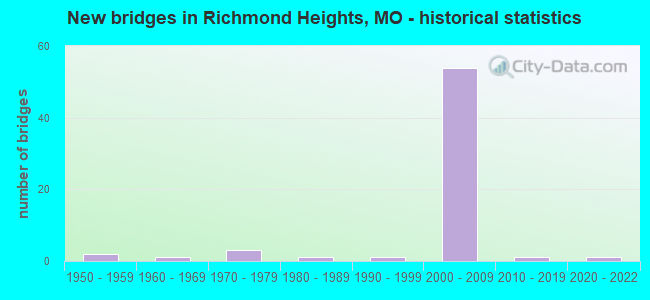
- New bridges - historical statistics
- 21950-1959
- 11960-1969
- 31970-1979
- 11980-1989
- 11990-1999
- 542000-2009
- 12010-2019
- 12020-2022

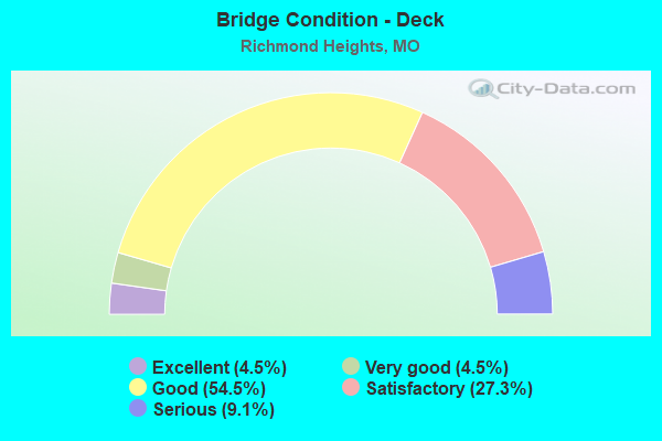
- Bridge Condition - Deck
- 4.5%Excellent
- 4.5%Very good
- 54.5%Good
- 27.3%Satisfactory
- 9.1%Serious
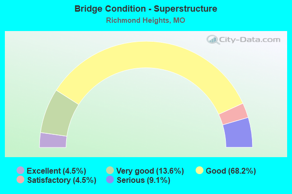
- Bridge Condition - Superstructure
- 4.5%Excellent
- 13.6%Very good
- 68.2%Good
- 4.5%Satisfactory
- 9.1%Serious
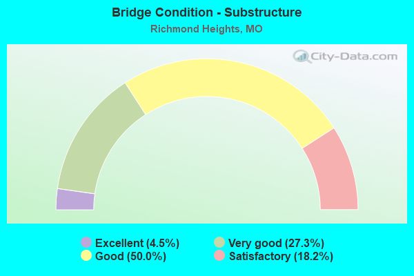
- Bridge Condition - Substructure
- 4.5%Excellent
- 27.3%Very good
- 50.0%Good
- 18.2%Satisfactory
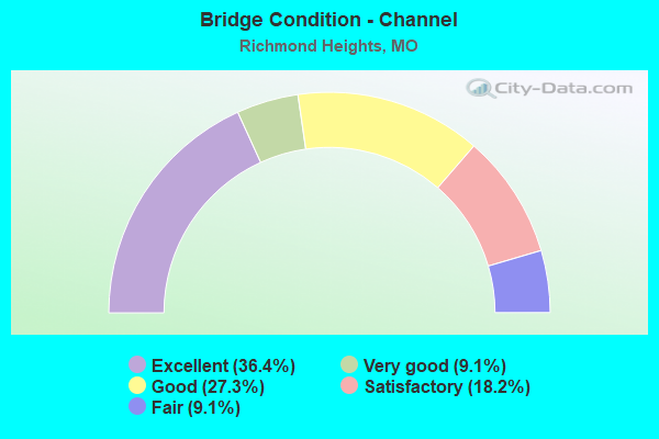
- Bridge Condition - Channel
- 36.4%Excellent
- 9.1%Very good
- 27.3%Good
- 18.2%Satisfactory
- 9.1%Fair
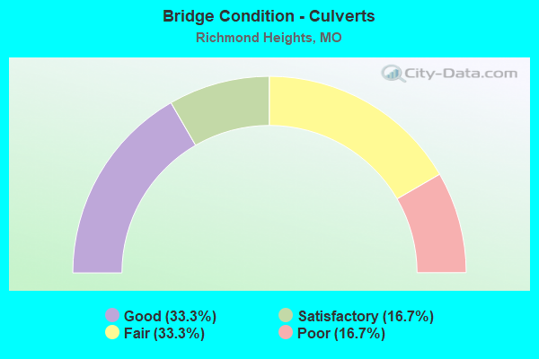
- Bridge Condition - Culverts
- 33.3%Good
- 16.7%Satisfactory
- 33.3%Fair
- 16.7%Poor
Find on map >> Show street view
Structure Number: 15602, Location: S 16 T 45 N R 6 E (Lat: 38.638606, Lng: -90.349453), Route carried "on" structure: County highway , Year Built: 1987, Status: Posted for load, Structure Length: 1.01m (3.31ft), Average Daily Traffic: 12,520 (year 2020), Truck Traffic: 5%, Average Future Daily Traffic: 16,902 (year 2040), Design Load: H 10, Features Intersected: BLACK CR, Facility Carried by Structure: CLAYTON RD
Minimum Vertical Clearance: 30+ m (98+ ft), Kilometerpoint: 11.104, Lanes on structure: 4, Owner: County Highway Agency, Approaching Roadway Width: 15.8m (51.8ft), Material/Design: Prestressed concrete, Design/Construction: Stringer/Multi-beam, Number Of Spans In Main Unit: 1, Length of Maximum Span: 9.1m (29.9ft), Curb or Sidewalk Widths: Left: 1.8m (5.9ft), Right: 1.8m (5.9ft), Curb-To-Curb Width: 15.8m (51.8ft), Out-to-Out Width: 20.3m (66.6ft)
Condition: Deck: Satisfactory, Superstructure: Good, Substructure: Satisfactory, Channel: Good, Operating Rating: 89.1 metric tons, Method Used To Determine Operating Rating: Allowable Stress (AS), Inventory Rating: 54.0 metric tons, Method Used To Determine Inventory Rating: Allowable Stress (AS), Structural Evaluation: Equal to present minimum criteria, Deck Geometry: Meets minimum limits, Waterway Adequacy: Superior to present desirable criteria, Approach Roadway Alignment: Better than present minimum criteria, Designated Inspection Frequency: Every 24 months, Inspection Date: April 2021, Deck Structure Type: Concrete Cast-file-Place, Wearing Surface/Protective System: Wearing Surface: Monolithic Concrete, Membrane: Epoxy, Deck Protection: Epoxy Coated Reinforcing
Find on map >> Show street view
Structure Number: 22696, Location: S 22 T 45 N R 6 E (Lat: 38.625308, Lng: -90.330567), Route carried "on" structure: City street , Year Built: 1976, Status: Posted for load, Structure Length: 0.79m (2.59ft), Average Daily Traffic: 10 (year 2020), Truck Traffic: 1%, Average Future Daily Traffic: 14 (year 2040), Features Intersected: HAMPTON CR, Facility Carried by Structure: ELINOR AVE
Minimum Vertical Clearance: 30+ m (98+ ft), Kilometerpoint: 0.322, Lanes on structure: 2, Owner: City or Municipal Highway Agency, Approaching Roadway Width: 8.5m (27.9ft), Material/Design: Prestressed concrete, Design/Construction: Box Beam or Girders - Multiple, Number Of Spans In Main Unit: 1, Length of Maximum Span: 7.6m (24.9ft), Curb-To-Curb Width: 8.7m (28.5ft), Out-to-Out Width: 9.3m (30.5ft)
Condition: Deck: Serious, Superstructure: Serious, Substructure: Satisfactory, Channel: Excellent, Operating Rating: 49.5 metric tons, Method Used To Determine Operating Rating: Allowable Stress (AS), Inventory Rating: 16.2 metric tons, Method Used To Determine Inventory Rating: Allowable Stress (AS), Structural Evaluation: High priority of corrective action, Deck Geometry: Better than present minimum criteria, Waterway Adequacy: Equal to present desirable criteria, Approach Roadway Alignment: Equal to present desirable criteria, Length Of Structure Improvement: 0.14m (0.46ft), Designated Inspection Frequency: Every 24 months, Inspection Date: December 2021, Bridge Improvement Cost: $102,000, Roadway Improvement Cost: $10,000, Total Project Cost: $153,000 ( Estimate for 2022), Deck Structure Type: Concrete Precast Panels, Wearing Surface/Protective System: Wearing Surface: Bituminous
Find on map >> Show street view
Structure Number: 22698, Location: S 22 T 45 N R 6 E (Lat: 38.627650, Lng: -90.324039), Route carried "on" structure: City street , Year Built: 1955, Status: Posted for load, Structure Length: 0.67m (2.20ft), Average Daily Traffic: 3,000 (year 2020), Truck Traffic: 1%, Average Future Daily Traffic: 4,050 (year 2040), Features Intersected: CLAYTONIA CR, Facility Carried by Structure: DALE AVE
Minimum Vertical Clearance: 30+ m (98+ ft), Kilometerpoint: 0.644, Lanes on structure: 2, Owner: City or Municipal Highway Agency, Approaching Roadway Width: 11.0m (36.1ft), Material/Design: Concrete continuous, Design/Construction: Culvert, Number Of Spans In Main Unit: 2, Length of Maximum Span: 3.0m (9.8ft)
Condition: Channel: Satisfactory, Culverts: Poor, Operating Rating: 45.0 metric tons, Method Used To Determine Operating Rating: Allowable Stress (AS), Inventory Rating: 22.5 metric tons, Method Used To Determine Inventory Rating: Allowable Stress (AS), Structural Evaluation: Meets minimum limits, Waterway Adequacy: Equal to present desirable criteria, Approach Roadway Alignment: Equal to present desirable criteria, Length Of Structure Improvement: 0.13m (0.43ft), Designated Inspection Frequency: Every 24 months, Inspection Date: December 2021, Bridge Improvement Cost: $85,000, Roadway Improvement Cost: $9,000, Total Project Cost: $128,000 ( Estimate for 2022)
Find on map >> Show street view
Structure Number: 22699, Location: S 22 T 45 N R 6 E (Lat: 38.628558, Lng: -90.323894), Route carried "on" structure: City street , Year Built: 1976, Status: Not yet open, Structure Length: 0.85m (2.79ft), Average Daily Traffic: 500 (year 2020), Truck Traffic: 1%, Average Future Daily Traffic: 675 (year 2040), Features Intersected: CLAYTONIA CR, Facility Carried by Structure: LOVELLA AVE
Minimum Vertical Clearance: 30+ m (98+ ft), Kilometerpoint: 0.805, Lanes on structure: 2, Owner: City or Municipal Highway Agency, Approaching Roadway Width: 7.6m (24.9ft), Material/Design: Prestressed concrete, Design/Construction: Box Beam or Girders - Multiple, Number Of Spans In Main Unit: 1, Length of Maximum Span: 8.2m (26.9ft), Curb-To-Curb Width: 7.6m (24.9ft), Out-to-Out Width: 10.1m (33.1ft)
Condition: Deck: Serious, Superstructure: Serious, Substructure: Good, Channel: Excellent, Operating Rating: 26.1 metric tons, Method Used To Determine Operating Rating: Field evaluation and documented engineering judgment, Inventory Rating: 18.0 metric tons, Method Used To Determine Inventory Rating: Field evaluation and documented engineering judgment, Structural Evaluation: High priority of corrective action, Deck Geometry: Meets minimum limits, Waterway Adequacy: Equal to present desirable criteria, Approach Roadway Alignment: Equal to present minimum criteria, Bridge Posting: Required (Relationship of Operating Rating to Maximum Legal Load: 30.0 - 39.9% below), Length Of Structure Improvement: 0.15m (0.49ft), Designated Inspection Frequency: Every 24 months, Inspection Date: December 2019, Bridge Improvement Cost: $162,000, Roadway Improvement Cost: $16,000, Total Project Cost: $243,000 ( Estimate for 2022), Deck Structure Type: Concrete Precast Panels, Wearing Surface/Protective System: Wearing Surface: Bituminous
Find on map >> Show street view
Structure Number: 29489, Location: S 22 T 45 N R 6 E (Lat: 38.627681, Lng: -90.332122), Route carried "on" structure: City street , Year Built: 2003, Status: Open, Structure Length: 0.62m (2.03ft), Average Daily Traffic: 6,000 (year 2020), Truck Traffic: 1%, Average Future Daily Traffic: 8,100 (year 2040), Design Load: HS 20, Features Intersected: HAMPTON CR, Facility Carried by Structure: DALE AVE
Minimum Vertical Clearance: 30+ m (98+ ft), Kilometerpoint: 0.000, Lanes on structure: 3, Owner: City or Municipal Highway Agency, Approaching Roadway Width: 11.1m (36.4ft), Skew: 1 degrees, Material/Design: Concrete, Design/Construction: Culvert, Number Of Spans In Main Unit: 1, Length of Maximum Span: 6.2m (20.3ft), Curb-To-Curb Width: 10.7m (35.1ft), Out-to-Out Width: 15.3m (50.2ft)
Condition: Channel: Excellent, Culverts: Good, Operating Rating: 54.0 metric tons, Method Used To Determine Operating Rating: Load Factor (LF), Inventory Rating: 32.4 metric tons, Method Used To Determine Inventory Rating: Load Factor (LF), Structural Evaluation: Better than present minimum criteria, Deck Geometry: High priority of replacement, Waterway Adequacy: Superior to present desirable criteria, Approach Roadway Alignment: Equal to present desirable criteria, Length Of Structure Improvement: 0.12m (0.39ft), Designated Inspection Frequency: Every 24 months, Inspection Date: December 2021, Bridge Improvement Cost: $85,000, Roadway Improvement Cost: $9,000, Total Project Cost: $128,000 ( Estimate for 2022)
Find on map >> Show street view
Structure Number: 32119, Location: S 21 T 45 N R 6 E (Lat: 38.630094, Lng: -90.342281), Route carried "on" structure: Ramp State highway , Year Built: 2007, Status: Open, Structure Length: 12.14m (39.83ft), Average Daily Traffic: 20,831 (year 2021), Truck Traffic: 19%, Average Future Daily Traffic: 26,039 (year 2041), Design Load: HS 25 or greater, Features Intersected: RP HANLEY DR TO IS64W, R, Facility Carried by Structure: RP IS64W TO IS170W
Minimum Vertical Clearance: 30+ m (98+ ft), Kilometerpoint: 0.288, Lanes on structure: 1, Lanes under structure: 3, Base Highway Network: Yes, Owner: State Highway Agency, Approaching Roadway Width: 8.2m (26.9ft), Material/Design: Steel continuous, Design/Construction: Stringer/Multi-beam, Number Of Spans In Main Unit: 2, Length of Maximum Span: 71.4m (234.3ft), Curb-To-Curb Width: 8.2m (26.9ft), Out-to-Out Width: 9.0m (29.5ft)
Condition: Deck: Good, Superstructure: Good, Substructure: Good, Operating Rating: 73.8 metric tons, Method Used To Determine Operating Rating: Load Factor (LF), Inventory Rating: 44.1 metric tons, Method Used To Determine Inventory Rating: Load Factor (LF), Structural Evaluation: Better than present minimum criteria, Deck Geometry: Superior to present desirable criteria, Approach Roadway Alignment: Better than present minimum criteria, Designated Inspection Frequency: Every 24 months, Inspection Date: October 2020, Deck Structure Type: Concrete Cast-file-Place, Wearing Surface/Protective System: Wearing Surface: Monolithic Concrete, Deck Protection: Epoxy Coated Reinforcing
Find on map >> Show street view
Structure Number: 32223, Location: S 23 T 45 N R 6 E (Lat: 38.628503, Lng: -90.312547), Route carried "on" structure: City street , Year Built: 2008, Status: Open, Structure Length: 4.45m (14.60ft), Average Daily Traffic: 5,985 (year 2021), Truck Traffic: 5%, Average Future Daily Traffic: 8,978 (year 2041), Design Load: HS 20, Features Intersected: IS 64, Facility Carried by Structure: BELLEVUE AVE S
Minimum Vertical Clearance: 30+ m (98+ ft), Kilometerpoint: 0.615, Lanes on structure: 3, Lanes under structure: 8, Owner: State Highway Agency, Approaching Roadway Width: 10.1m (33.1ft), Skew: 1 degrees, Material/Design: Prestressed concrete continuous, Design/Construction: Stringer/Multi-beam, Number Of Spans In Main Unit: 2, Length of Maximum Span: 21.9m (71.9ft), Curb-To-Curb Width: 14.0m (45.9ft), Out-to-Out Width: 18.3m (60.0ft)
Condition: Deck: Good, Superstructure: Good, Substructure: Good, Operating Rating: 77.4 metric tons, Method Used To Determine Operating Rating: Load Factor (LF), Inventory Rating: 45.9 metric tons, Method Used To Determine Inventory Rating: Load Factor (LF), Structural Evaluation: Better than present minimum criteria, Deck Geometry: Somewhat better than minimum adequacy, Underclear: High priority of corrective action, Approach Roadway Alignment: Equal to present desirable criteria, Designated Inspection Frequency: Every 48 months, Inspection Date: October 2018, Deck Structure Type: Concrete Cast-file-Place, Wearing Surface/Protective System: Wearing Surface: Monolithic Concrete, Deck Protection: Epoxy Coated Reinforcing
Find on map >> Show street view
Structure Number: 32224, Location: S 22 T 45 N R 6 E (Lat: 38.629564, Lng: -90.327756), Route carried "on" structure: City street , Year Built: 2008, Status: Open, Structure Length: 4.45m (14.60ft), Average Daily Traffic: 1,008 (year 2021), Truck Traffic: 5%, Average Future Daily Traffic: 1,512 (year 2041), Design Load: HS 20, Features Intersected: IS 64, Facility Carried by Structure: BOLAND PL S
Minimum Vertical Clearance: 30+ m (98+ ft), Kilometerpoint: 0.724, Lanes on structure: 2, Lanes under structure: 8, Owner: State Highway Agency, Approaching Roadway Width: 8.2m (26.9ft), Material/Design: Prestressed concrete continuous, Design/Construction: Stringer/Multi-beam, Number Of Spans In Main Unit: 2, Length of Maximum Span: 21.9m (71.9ft), Curb or Sidewalk Widths: Left: 1.8m (5.9ft), Right: 1.8m (5.9ft), Curb-To-Curb Width: 8.2m (26.9ft), Out-to-Out Width: 12.5m (41.0ft)
Condition: Deck: Good, Superstructure: Good, Substructure: Satisfactory, Operating Rating: 93.6 metric tons, Method Used To Determine Operating Rating: Load Factor (LF), Inventory Rating: 44.1 metric tons, Method Used To Determine Inventory Rating: Load Factor (LF), Structural Evaluation: Equal to present minimum criteria, Deck Geometry: Meets minimum limits, Underclear: Meets minimum limits, Approach Roadway Alignment: Equal to present desirable criteria, Designated Inspection Frequency: Every 24 months, Inspection Date: October 2020, Deck Structure Type: Concrete Cast-file-Place, Wearing Surface/Protective System: Wearing Surface: Epoxy Overlay, Deck Protection: Epoxy Coated Reinforcing
Find on map >> Show street view
Structure Number: 32228, Location: S 23 T 45 N R 6 E (Lat: 38.628722, Lng: -90.316461), Route carried "on" structure: City street , Year Built: 2008, Status: Open, Structure Length: 6.74m (22.11ft), Average Daily Traffic: 10,172 (year 2021), Truck Traffic: 5%, Average Future Daily Traffic: 15,258 (year 2041), Design Load: HS 20, Features Intersected: IS 64, RP IS64W TO BIG B, Facility Carried by Structure: HIGHLAND TER N
Minimum Vertical Clearance: 30+ m (98+ ft), Kilometerpoint: 0.071, Lanes on structure: 2, Lanes under structure: 12, Owner: State Highway Agency, Approaching Roadway Width: 8.2m (26.9ft), Skew: 2 degrees, Material/Design: Prestressed concrete continuous, Design/Construction: Stringer/Multi-beam, Number Of Spans In Main Unit: 2, Length of Maximum Span: 32.9m (107.9ft), Curb-To-Curb Width: 8.2m (26.9ft), Out-to-Out Width: 12.5m (41.0ft)
Condition: Deck: Good, Superstructure: Good, Substructure: Good, Operating Rating: 79.2 metric tons, Method Used To Determine Operating Rating: Load Factor (LF), Inventory Rating: 47.7 metric tons, Method Used To Determine Inventory Rating: Load Factor (LF), Structural Evaluation: Better than present minimum criteria, Deck Geometry: High priority of corrective action, Approach Roadway Alignment: Equal to present desirable criteria, Length Of Structure Improvement: 0.78m (2.56ft), Designated Inspection Frequency: Every 24 months, Inspection Date: October 2020, Bridge Improvement Cost: $606,000, Roadway Improvement Cost: $61,000, Total Project Cost: $909,000 ( Estimate for 2022), Deck Structure Type: Concrete Cast-file-Place, Wearing Surface/Protective System: Wearing Surface: Epoxy Overlay, Deck Protection: Epoxy Coated Reinforcing
Find on map >> Show street view
Structure Number: 32229, Location: S 16 T 45 N R 6 E (Lat: 38.631714, Lng: -90.344650), Route carried "on" structure: Ramp State highway , Year Built: 2008, Status: Open, Structure Length: 8.93m (29.30ft), Average Daily Traffic: 17,904 (year 2021), Truck Traffic: 4%, Average Future Daily Traffic: 22,380 (year 2041), Design Load: HS 20, Features Intersected: IS 170, RP IS170E TO BRE, Facility Carried by Structure: RP IS170E TO IS64W
Minimum Vertical Clearance: 30+ m (98+ ft), Kilometerpoint: 0.301, Lanes on structure: 1, Lanes under structure: 3, Base Highway Network: Yes, Owner: State Highway Agency, Approaching Roadway Width: 8.2m (26.9ft), Skew: 2 degrees, Material/Design: Steel continuous, Design/Construction: Stringer/Multi-beam, Number Of Spans In Main Unit: 2, Length of Maximum Span: 44.9m (147.3ft), Curb-To-Curb Width: 8.2m (26.9ft), Out-to-Out Width: 9.0m (29.5ft)
Condition: Deck: Good, Superstructure: Very good, Substructure: Good, Operating Rating: 81.0 metric tons, Method Used To Determine Operating Rating: Load Factor (LF), Inventory Rating: 48.6 metric tons, Method Used To Determine Inventory Rating: Load Factor (LF), Structural Evaluation: Better than present minimum criteria, Deck Geometry: Superior to present desirable criteria, Underclear: High priority of corrective action, Approach Roadway Alignment: Better than present minimum criteria, Designated Inspection Frequency: Every 24 months, Inspection Date: October 2020, Deck Structure Type: Concrete Cast-file-Place, Wearing Surface/Protective System: Wearing Surface: Monolithic Concrete, Deck Protection: Epoxy Coated Reinforcing
Find on map >> Show street view
Structure Number: 32232, Location: S 21 T 45 N R 6 E (Lat: 38.629922, Lng: -90.345244), Route carried "on" structure: Ramp State highway , Year Built: 2008, Status: Open, Structure Length: 42.20m (138.45ft), Average Daily Traffic: 17,626 (year 2021), Truck Traffic: 10%, Average Future Daily Traffic: 22,033 (year 2041), Design Load: HS 25 or greater, Features Intersected: IS 64, RP HANLEY DR TO I, Facility Carried by Structure: RP IS64E TO IS170W
Minimum Vertical Clearance: 30+ m (98+ ft), Kilometerpoint: 0.595, Lanes on structure: 1, Lanes under structure: 14, Base Highway Network: Yes, Owner: State Highway Agency, Approaching Roadway Width: 8.2m (26.9ft), Material/Design: Steel continuous, Design/Construction: Stringer/Multi-beam, Number Of Spans In Main Unit: 4, Number Of Approach Spans: 4, Length of Maximum Span: 75.9m (249.0ft), Curb-To-Curb Width: 8.2m (26.9ft), Out-to-Out Width: 9.0m (29.5ft)
Condition: Deck: Satisfactory, Superstructure: Good, Substructure: Satisfactory, Operating Rating: 81.0 metric tons, Method Used To Determine Operating Rating: Load Factor (LF), Inventory Rating: 48.6 metric tons, Method Used To Determine Inventory Rating: Load Factor (LF), Structural Evaluation: Equal to present minimum criteria, Deck Geometry: Superior to present desirable criteria, Underclear: High priority of corrective action, Approach Roadway Alignment: Equal to present desirable criteria, Designated Inspection Frequency: Every 24 months, Inspection Date: June 2020, Deck Structure Type: Concrete Cast-file-Place, Wearing Surface/Protective System: Wearing Surface: Monolithic Concrete, Deck Protection: Epoxy Coated Reinforcing
Find on map >> Show street view
Structure Number: 32233, Location: S 21 T 45 N R 6 E (Lat: 38.629939, Lng: -90.343253), Route carried "on" structure: Ramp State highway , Year Built: 2008, Status: Open, Structure Length: 35.79m (117.42ft), Average Daily Traffic: 21,276 (year 2021), Truck Traffic: 4%, Average Future Daily Traffic: 26,595 (year 2041), Design Load: HS 25 or greater, Features Intersected: IS 64, RP HANLEY DR TO I, Facility Carried by Structure: RP IS170E TO IS64E
Minimum Vertical Clearance: 4.75m (15.58ft), Kilometerpoint: 0.396, Lanes on structure: 1, Lanes under structure: 10, Base Highway Network: Yes, Owner: State Highway Agency, Approaching Roadway Width: 8.2m (26.9ft), Material/Design: Steel continuous, Design/Construction: Stringer/Multi-beam, Number Of Spans In Main Unit: 3, Number Of Approach Spans: 3, Length of Maximum Span: 75.0m (246.1ft), Curb-To-Curb Width: 8.2m (26.9ft), Out-to-Out Width: 9.0m (29.5ft)
Condition: Deck: Satisfactory, Superstructure: Very good, Substructure: Very good, Operating Rating: 75.6 metric tons, Method Used To Determine Operating Rating: Load Factor (LF), Inventory Rating: 45.0 metric tons, Method Used To Determine Inventory Rating: Load Factor (LF), Structural Evaluation: Equal to present desirable criteria, Deck Geometry: Meets minimum limits, Underclear: High priority of corrective action, Approach Roadway Alignment: Equal to present desirable criteria, Designated Inspection Frequency: Every 24 months, Inspection Date: June 2021, Deck Structure Type: Concrete Cast-file-Place, Wearing Surface/Protective System: Wearing Surface: Monolithic Concrete, Deck Protection: Epoxy Coated Reinforcing
Find on map >> Show street view
Structure Number: 32248, Location: S 21 T 45 N R 6 E (Lat: 38.629111, Lng: -90.338028), Route carried "on" structure: Interstate 64, Year Built: 2008, Status: Open, Structure Length: 1.30m (4.27ft), Average Daily Traffic: 155,732 (year 2021), Truck Traffic: 12%, Average Future Daily Traffic: 194,665 (year 2041), Design Load: HS 25 or greater, Features Intersected: METROLINK
Minimum Vertical Clearance: 30+ m (98+ ft), Kilometerpoint: 51.641, Lanes on structure: 8, Base Highway Network: Yes, Owner: State Highway Agency, Approaching Roadway Width: 45.7m (149.9ft), Material/Design: Concrete continuous, Design/Construction: Slab, Number Of Spans In Main Unit: 3, Length of Maximum Span: 4.6m (15.1ft), Curb-To-Curb Width: 45.7m (149.9ft), Out-to-Out Width: 45.7m (149.9ft)
Condition: Deck: Very good, Superstructure: Very good, Substructure: Very good, Inventory Rating: 92.7 metric tons, Method Used To Determine Inventory Rating: Load Factor (LF), Structural Evaluation: Equal to present desirable criteria, Deck Geometry: Superior to present desirable criteria, Underclear: High priority of corrective action, Approach Roadway Alignment: Equal to present desirable criteria, Designated Inspection Frequency: Every 24 months, Inspection Date: September 2021, Deck Structure Type: Concrete Cast-file-Place
Find on map >> Show street view
Structure Number: 32249, Location: S 22 T 45 N R 6 E (Lat: 38.629572, Lng: -90.329789), Route carried "on" structure: Interstate 64, Year Built: 2008, Status: Open, Structure Length: 1.41m (4.63ft), Average Daily Traffic: 163,129 (year 2021), Truck Traffic: 12%, Average Future Daily Traffic: 203,911 (year 2041), Design Load: HS 25 or greater, Features Intersected: CST LACLEDE STATION RD
Minimum Vertical Clearance: 30+ m (98+ ft), Kilometerpoint: 52.338, Lanes on structure: 10, Lanes under structure: 2, Base Highway Network: Yes, Owner: State Highway Agency, Approaching Roadway Width: 23.2m (76.1ft), Material/Design: Prestressed concrete, Design/Construction: Stringer/Multi-beam, Number Of Spans In Main Unit: 1, Length of Maximum Span: 14.0m (45.9ft), Curb-To-Curb Width: 46.3m (151.9ft), Out-to-Out Width: 47.1m (154.5ft)
Condition: Deck: Satisfactory, Superstructure: Good, Substructure: Good, Operating Rating: 83.7 metric tons, Method Used To Determine Operating Rating: Load Factor (LF), Inventory Rating: 50.4 metric tons, Method Used To Determine Inventory Rating: Load Factor (LF), Structural Evaluation: Better than present minimum criteria, Deck Geometry: Superior to present desirable criteria, Underclear: High priority of corrective action, Approach Roadway Alignment: Equal to present desirable criteria, Designated Inspection Frequency: Every 24 months, Inspection Date: October 2020, Deck Structure Type: Concrete Cast-file-Place, Wearing Surface/Protective System: Wearing Surface: Epoxy Overlay, Deck Protection: Epoxy Coated Reinforcing
Find on map >> Show street view
Structure Number: 3225, Location: S 23 T 32 N R 4 E (Lat: 37.444158, Lng: -90.572486), Route carried "on" structure: State highway E, Year Built: 1978, Status: Open, Structure Length: 0.64m (2.10ft), Average Daily Traffic: 1,107 (year 2021), Truck Traffic: 7%, Average Future Daily Traffic: 1,550 (year 2041), Design Load: H 15, Features Intersected: MARBLE CR
Minimum Vertical Clearance: 30+ m (98+ ft), Kilometerpoint: 16.863, Lanes on structure: 2, Owner: State Highway Agency, Approaching Roadway Width: 8.5m (27.9ft), Skew: 1 degrees, Material/Design: Concrete continuous, Design/Construction: Culvert, Number Of Spans In Main Unit: 2, Length of Maximum Span: 3.0m (9.8ft), Curb-To-Curb Width: 11.1m (36.4ft), Out-to-Out Width: 11.7m (38.4ft)
Condition: Channel: Good, Culverts: Good, Operating Rating: 62.1 metric tons, Method Used To Determine Operating Rating: Load Factor (LF), Inventory Rating: 36.9 metric tons, Method Used To Determine Inventory Rating: Load Factor (LF), Structural Evaluation: Better than present minimum criteria, Deck Geometry: Equal to present minimum criteria, Waterway Adequacy: Equal to present desirable criteria, Approach Roadway Alignment: Equal to present desirable criteria, Designated Inspection Frequency: Every 24 months, Inspection Date: October 2021
Find on map >> Show street view
Structure Number: 3225, Location: S 23 T 45 N R 6 E (Lat: 38.629033, Lng: -90.319733), Route carried "on" structure: City street , Year Built: 2008, Status: Open, Structure Length: 7.25m (23.79ft), Average Daily Traffic: 26,602 (year 2021), Truck Traffic: 5%, Average Future Daily Traffic: 37,243 (year 2041), Design Load: HS 20+Mod, Features Intersected: IS 64, Facility Carried by Structure: BIG BEND BLVD E
Minimum Vertical Clearance: 30+ m (98+ ft), Kilometerpoint: 8.718, Lanes on structure: 6, Lanes under structure: 6, Owner: State Highway Agency, Approaching Roadway Width: 30.8m (101.0ft), Material/Design: Prestressed concrete, Design/Construction: Tee Beam, Number Of Spans In Main Unit: 1, Length of Maximum Span: 37.6m (123.4ft), Curb-To-Curb Width: 26.5m (86.9ft), Out-to-Out Width: 30.8m (101.0ft)
Condition: Deck: Good, Superstructure: Good, Substructure: Good, Operating Rating: 91.8 metric tons, Method Used To Determine Operating Rating: Load Factor (LF), Inventory Rating: 38.7 metric tons, Method Used To Determine Inventory Rating: Load Factor (LF), Structural Evaluation: Better than present minimum criteria, Deck Geometry: Equal to present minimum criteria, Underclear: Meets minimum limits, Approach Roadway Alignment: Equal to present desirable criteria, Designated Inspection Frequency: Every 24 months, Inspection Date: October 2020, Deck Structure Type: Concrete Cast-file-Place, Wearing Surface/Protective System: Wearing Surface: Monolithic Concrete, Deck Protection: Epoxy Coated Reinforcing
Find on map >> Show street view
Structure Number: 32256, Location: S 20 T 45 N R 6 E (Lat: 38.631647, Lng: -90.354450), Route carried "on" structure: City street , Year Built: 2008, Status: Open, Structure Length: 5.38m (17.65ft), Average Daily Traffic: 1,778 (year 2021), Truck Traffic: 1%, Average Future Daily Traffic: 2,667 (year 2041), Design Load: HS 20, Features Intersected: IS 64, Facility Carried by Structure: MC CUTCHEON RD S
Minimum Vertical Clearance: 30+ m (98+ ft), Kilometerpoint: 0.851, Lanes on structure: 2, Lanes under structure: 10, Owner: State Highway Agency, Approaching Roadway Width: 8.5m (27.9ft), Material/Design: Prestressed concrete continuous, Design/Construction: Stringer/Multi-beam, Number Of Spans In Main Unit: 2, Length of Maximum Span: 27.4m (89.9ft), Curb or Sidewalk Widths: Left: 0.0m, Right: 1.6m (5.2ft), Curb-To-Curb Width: 8.5m (27.9ft), Out-to-Out Width: 12.3m (40.4ft)
Condition: Deck: Good, Superstructure: Good, Substructure: Very good, Operating Rating: 82.8 metric tons, Method Used To Determine Operating Rating: Load Factor (LF), Inventory Rating: 38.7 metric tons, Method Used To Determine Inventory Rating: Load Factor (LF), Structural Evaluation: Better than present minimum criteria, Deck Geometry: Somewhat better than minimum adequacy, Underclear: High priority of corrective action, Approach Roadway Alignment: Equal to present desirable criteria, Designated Inspection Frequency: Every 48 months, Inspection Date: October 2018, Deck Structure Type: Concrete Cast-file-Place, Wearing Surface/Protective System: Wearing Surface: Epoxy Overlay, Deck Protection: Epoxy Coated Reinforcing
Find on map >> Show street view
Structure Number: 32261, Location: S 16 T 45 N R 6 E (Lat: 38.630361, Lng: -90.346161), Route carried "on" structure: Ramp State highway , Year Built: 2008, Status: Open, Structure Length: 6.43m (21.10ft), Average Daily Traffic: 17,904 (year 2021), Truck Traffic: 4%, Average Future Daily Traffic: 22,380 (year 2041), Design Load: HS 20, Features Intersected: CST S BRENTWOOD BLVD, Facility Carried by Structure: RP IS170E TO IS64W
Minimum Vertical Clearance: 30+ m (98+ ft), Kilometerpoint: 0.521, Lanes on structure: 1, Lanes under structure: 10, Base Highway Network: Yes, Owner: State Highway Agency, Approaching Roadway Width: 8.2m (26.9ft), Skew: 1 degrees, Material/Design: Prestressed concrete continuous, Design/Construction: Tee Beam, Number Of Spans In Main Unit: 2, Length of Maximum Span: 36.0m (118.1ft), Curb-To-Curb Width: 8.2m (26.9ft), Out-to-Out Width: 9.0m (29.5ft)
Condition: Deck: Good, Superstructure: Good, Substructure: Very good, Operating Rating: 66.6 metric tons, Method Used To Determine Operating Rating: Load Factor (LF), Inventory Rating: 35.1 metric tons, Method Used To Determine Inventory Rating: Load Factor (LF), Structural Evaluation: Better than present minimum criteria, Deck Geometry: Superior to present desirable criteria, Approach Roadway Alignment: Better than present minimum criteria, Designated Inspection Frequency: Every 24 months, Inspection Date: October 2020, Deck Structure Type: Concrete Cast-file-Place, Wearing Surface/Protective System: Wearing Surface: Monolithic Concrete, Deck Protection: Epoxy Coated Reinforcing
Find on map >> Show street view
Structure Number: 32263, Location: S 21 T 45 N R 6 E (Lat: 38.629450, Lng: -90.343619), Route carried "on" structure: Ramp State highway , Year Built: 2008, Status: Open, Structure Length: 2.83m (9.28ft), Average Daily Traffic: 14,490 (year 2021), Truck Traffic: 18%, Average Future Daily Traffic: 18,113 (year 2041), Design Load: HS 20, Features Intersected: IS 170, Facility Carried by Structure: RP BRENTWOOD BLVD
Minimum Vertical Clearance: 30+ m (98+ ft), Kilometerpoint: 0.211, Lanes on structure: 2, Lanes under structure: 5, Base Highway Network: Yes, Owner: State Highway Agency, Approaching Roadway Width: 7.3m (24.0ft), Skew: 1 degrees, Material/Design: Prestressed concrete, Design/Construction: Tee Beam, Number Of Spans In Main Unit: 1, Length of Maximum Span: 28.3m (92.8ft), Curb-To-Curb Width: 11.0m (36.1ft), Out-to-Out Width: 11.8m (38.7ft)
Condition: Deck: Good, Superstructure: Good, Substructure: Very good, Operating Rating: 75.6 metric tons, Method Used To Determine Operating Rating: Load Factor (LF), Inventory Rating: 39.6 metric tons, Method Used To Determine Inventory Rating: Load Factor (LF), Structural Evaluation: Better than present minimum criteria, Deck Geometry: Better than present minimum criteria, Underclear: High priority of corrective action, Approach Roadway Alignment: Equal to present desirable criteria, Designated Inspection Frequency: Every 24 months, Inspection Date: October 2020, Deck Structure Type: Concrete Cast-file-Place, Wearing Surface/Protective System: Wearing Surface: Epoxy Overlay, Deck Protection: Epoxy Coated Reinforcing
Find on map >> Show street view
Structure Number: 32264, Location: S 21 T 45 N R 6 E (Lat: 38.630117, Lng: -90.343822), Route carried "on" structure: Ramp State highway , Year Built: 2008, Status: Open, Structure Length: 2.90m (9.51ft), Average Daily Traffic: 9,164 (year 2021), Truck Traffic: 19%, Average Future Daily Traffic: 11,455 (year 2041), Design Load: HS 20+Mod, Features Intersected: IS 170, Facility Carried by Structure: RP HANLEY DR TO IS
Minimum Vertical Clearance: 30+ m (98+ ft), Kilometerpoint: 0.776, Lanes on structure: 2, Lanes under structure: 5, Base Highway Network: Yes, Owner: State Highway Agency, Approaching Roadway Width: 11.0m (36.1ft), Skew: 2 degrees, Material/Design: Prestressed concrete, Design/Construction: Tee Beam, Number Of Spans In Main Unit: 1, Length of Maximum Span: 28.7m (94.2ft), Curb-To-Curb Width: 11.0m (36.1ft), Out-to-Out Width: 11.8m (38.7ft)
Condition: Deck: Good, Superstructure: Good, Substructure: Good, Operating Rating: 72.0 metric tons, Method Used To Determine Operating Rating: Load Factor (LF), Inventory Rating: 37.8 metric tons, Method Used To Determine Inventory Rating: Load Factor (LF), Structural Evaluation: Better than present minimum criteria, Deck Geometry: Better than present minimum criteria, Underclear: High priority of corrective action, Approach Roadway Alignment: Equal to present desirable criteria, Designated Inspection Frequency: Every 24 months, Inspection Date: October 2020, Deck Structure Type: Concrete Cast-file-Place, Wearing Surface/Protective System: Wearing Surface: Epoxy Overlay, Deck Protection: Epoxy Coated Reinforcing
Find on map >> Show street view
Structure Number: 32265, Location: S 21 T 45 N R 6 E (Lat: 38.629708, Lng: -90.343731), Route carried "on" structure: Interstate 64, Year Built: 2008, Status: Open, Structure Length: 2.82m (9.25ft), Average Daily Traffic: 153,638 (year 2021), Truck Traffic: 12%, Average Future Daily Traffic: 192,048 (year 2041), Design Load: HS 25 or greater, Features Intersected: IS 170
Minimum Vertical Clearance: 30+ m (98+ ft), Kilometerpoint: 51.116, Lanes on structure: 6, Lanes under structure: 5, Base Highway Network: Yes, Owner: State Highway Agency, Approaching Roadway Width: 16.2m (53.1ft), Skew: 1 degrees, Material/Design: Prestressed concrete, Design/Construction: Tee Beam, Number Of Spans In Main Unit: 1, Length of Maximum Span: 28.2m (92.5ft), Curb-To-Curb Width: 32.3m (106.0ft), Out-to-Out Width: 33.7m (110.6ft)
Condition: Deck: Good, Superstructure: Good, Substructure: Very good, Operating Rating: 71.1 metric tons, Method Used To Determine Operating Rating: Load Factor (LF), Inventory Rating: 36.0 metric tons, Method Used To Determine Inventory Rating: Load Factor (LF), Structural Evaluation: Better than present minimum criteria, Deck Geometry: Superior to present desirable criteria, Underclear: High priority of corrective action, Approach Roadway Alignment: Equal to present desirable criteria, Designated Inspection Frequency: Every 24 months, Inspection Date: October 2020, Deck Structure Type: Concrete Cast-file-Place, Wearing Surface/Protective System: Wearing Surface: Epoxy Overlay, Deck Protection: Epoxy Coated Reinforcing
Find on map >> Show street view
Structure Number: 32267, Location: S 22 T 45 N R 6 E (Lat: 38.629322, Lng: -90.323331), Route carried "on" structure: Interstate 64, Year Built: 2008, Status: Open, Structure Length: 1.54m (5.05ft), Average Daily Traffic: 163,129 (year 2021), Truck Traffic: 12%, Average Future Daily Traffic: 203,911 (year 2041), Design Load: HS 25 or greater, Features Intersected: CST CLAYTONIA TER
Minimum Vertical Clearance: 30+ m (98+ ft), Kilometerpoint: 52.902, Lanes on structure: 8, Lanes under structure: 2, Base Highway Network: Yes, Owner: State Highway Agency, Approaching Roadway Width: 20.5m (67.3ft), Material/Design: Prestressed concrete, Design/Construction: Stringer/Multi-beam, Number Of Spans In Main Unit: 1, Length of Maximum Span: 15.4m (50.5ft), Curb-To-Curb Width: 42.2m (138.5ft), Out-to-Out Width: 43.0m (141.1ft)
Condition: Deck: Satisfactory, Superstructure: Good, Substructure: Good, Operating Rating: 81.0 metric tons, Method Used To Determine Operating Rating: Load Factor (LF), Inventory Rating: 48.6 metric tons, Method Used To Determine Inventory Rating: Load Factor (LF), Structural Evaluation: Better than present minimum criteria, Deck Geometry: Superior to present desirable criteria, Underclear: High priority of corrective action, Approach Roadway Alignment: Equal to present desirable criteria, Designated Inspection Frequency: Every 24 months, Inspection Date: October 2020, Deck Structure Type: Concrete Cast-file-Place, Wearing Surface/Protective System: Wearing Surface: Epoxy Overlay, Deck Protection: Epoxy Coated Reinforcing
Find on map >> Show street view
Structure Number: 3227, Location: S 21 T 45 N R 6 E (Lat: 38.629867, Lng: -90.346208), Route carried "on" structure: Interstate 64, Year Built: 2008, Status: Open, Structure Length: 4.51m (14.80ft), Average Daily Traffic: 152,645 (year 2021), Truck Traffic: 12%, Average Future Daily Traffic: 190,806 (year 2041), Design Load: HS 25 or greater, Features Intersected: CST S BRENTWOOD BLVD
Minimum Vertical Clearance: 30+ m (98+ ft), Kilometerpoint: 50.896, Lanes on structure: 6, Lanes under structure: 10, Base Highway Network: Yes, Owner: State Highway Agency, Approaching Roadway Width: 16.5m (54.1ft), Material/Design: Prestressed concrete, Design/Construction: Stringer/Multi-beam, Number Of Spans In Main Unit: 1, Length of Maximum Span: 44.7m (146.7ft), Curb-To-Curb Width: 32.9m (107.9ft), Out-to-Out Width: 33.7m (110.6ft)
Condition: Deck: Good, Superstructure: Good, Substructure: Good, Inventory Rating: 35.1 metric tons, Method Used To Determine Inventory Rating: Load Factor (LF), Structural Evaluation: Better than present minimum criteria, Deck Geometry: Superior to present desirable criteria, Approach Roadway Alignment: Equal to present desirable criteria, Designated Inspection Frequency: Every 24 months, Inspection Date: October 2020, Deck Structure Type: Concrete Cast-file-Place, Wearing Surface/Protective System: Wearing Surface: Epoxy Overlay, Deck Protection: Epoxy Coated Reinforcing
Find on map >> Show street view
Structure Number: 3309, Location: S 22 T 45 N R 6 E (Lat: 38.624683, Lng: -90.329808), Route carried "on" structure: City street , Year Built: 2010, Status: Posted for load, Structure Length: 0.82m (2.69ft), Average Daily Traffic: 5,000 (year 2020), Truck Traffic: 1%, Average Future Daily Traffic: 6,750 (year 2040), Design Load: HS 20, Features Intersected: HAMPTON CR, Facility Carried by Structure: LACLEDE STATION RD
Minimum Vertical Clearance: 30+ m (98+ ft), Kilometerpoint: 1.110, Lanes on structure: 2, Owner: City or Municipal Highway Agency, Approaching Roadway Width: 10.7m (35.1ft), Skew: 4 degrees, Material/Design: Concrete, Design/Construction: Frame, Number Of Spans In Main Unit: 1, Length of Maximum Span: 6.1m (20.0ft), Curb-To-Curb Width: 10.7m (35.1ft), Out-to-Out Width: 19.7m (64.6ft)
Condition: Deck: Satisfactory, Superstructure: Satisfactory, Substructure: Good, Channel: Excellent, Operating Rating: 54.0 metric tons, Method Used To Determine Operating Rating: Load Factor (LF), Inventory Rating: 32.4 metric tons, Method Used To Determine Inventory Rating: Load Factor (LF), Structural Evaluation: Equal to present minimum criteria, Deck Geometry: Somewhat better than minimum adequacy, Waterway Adequacy: Superior to present desirable criteria, Approach Roadway Alignment: Equal to present desirable criteria, Designated Inspection Frequency: Every 24 months, Inspection Date: December 2021, Deck Structure Type: Concrete Cast-file-Place, Wearing Surface/Protective System: Wearing Surface: Monolithic Concrete
Find on map >> Show street view
Structure Number: 36217, Location: S 2484 T 45 N R 6 E (Lat: 38.623694, Lng: -90.325889), Route carried "on" structure: City street , Year Built: 1990, Status: Open, Structure Length: 0.63m (2.07ft), Average Daily Traffic: 750 (year 2020), Truck Traffic: 5%, Average Future Daily Traffic: 1,013 (year 2040), Features Intersected: CLAYTONIA CR, Facility Carried by Structure: BREDELL AVE
Minimum Vertical Clearance: 30+ m (98+ ft), Kilometerpoint: 0.000, Lanes on structure: 2, Owner: City or Municipal Highway Agency, Approaching Roadway Width: 7.9m (25.9ft), Skew: 1 degrees, Material/Design: Concrete, Design/Construction: Culvert, Number Of Spans In Main Unit: 2, Length of Maximum Span: 2.9m (9.5ft), Curb-To-Curb Width: 7.9m (25.9ft), Out-to-Out Width: 19.8m (65.0ft)
Condition: Channel: Good, Culverts: Satisfactory, Operating Rating: 54.0 metric tons, Method Used To Determine Operating Rating: Field evaluation and documented engineering judgment, Inventory Rating: 32.4 metric tons, Method Used To Determine Inventory Rating: Field evaluation and documented engineering judgment, Structural Evaluation: Equal to present minimum criteria, Deck Geometry: Somewhat better than minimum adequacy, Waterway Adequacy: Superior to present desirable criteria, Approach Roadway Alignment: Equal to present desirable criteria, Designated Inspection Frequency: Every 24 months, Inspection Date: December 2021
Find on map >> Show street view
Structure Number: 36413, Location: S 22 T 45 N R 6 E (Lat: 38.628611, Lng: -90.323889), Route carried "on" structure: City street 369, Year Built: 2020, Status: Not yet open, Structure Length: 0.83m (2.72ft), Average Daily Traffic: 500 (year 2020), Truck Traffic: 1%, Average Future Daily Traffic: 675 (year 2040), Design Load: HS 20, Features Intersected: CLAYTONIA CR, Facility Carried by Structure: LOVELLA AVE
Minimum Vertical Clearance: 30+ m (98+ ft), Kilometerpoint: 0.805, Lanes on structure: 2, Owner: City or Municipal Highway Agency, Approaching Roadway Width: 7.3m (24.0ft), Material/Design: Concrete, Design/Construction: Box Beam or Girders - Single/Spread, Number Of Spans In Main Unit: 1, Length of Maximum Span: 7.1m (23.3ft), Curb or Sidewalk Widths: Left: 3.0m (9.8ft), Right: 3.0m (9.8ft), Curb-To-Curb Width: 7.3m (24.0ft), Out-to-Out Width: 14.0m (45.9ft)
Condition: Deck: Excellent, Superstructure: Excellent, Substructure: Excellent, Channel: Very good, Operating Rating: 63.0 metric tons, Method Used To Determine Operating Rating: Load Factor (LF), Inventory Rating: 37.8 metric tons, Method Used To Determine Inventory Rating: Load Factor (LF), Structural Evaluation: Superior to present desirable criteria, Deck Geometry: Meets minimum limits, Waterway Adequacy: Superior to present desirable criteria, Approach Roadway Alignment: Equal to present desirable criteria, Designated Inspection Frequency: Every 24 months, Inspection Date: August 2020, Deck Structure Type: Concrete Cast-file-Place, Wearing Surface/Protective System: Wearing Surface: Integral Concrete, Deck Protection: Epoxy Coated Reinforcing
Find on map >> Show street view
Structure Number: 599, Location: S 5 T 38 N R 25 W (Lat: 38.085583, Lng: -93.707236), Route carried "on" structure: State highway 13, Year Built: 1963, Year Reconstructed: 2000, Status: Open, Structure Length: 0.88m (2.89ft), Average Daily Traffic: 14,335 (year 2021), Truck Traffic: 31%, Average Future Daily Traffic: 25,086 (year 2041), Design Load: H 20, Features Intersected: GALLINIPPER CR BR
Minimum Vertical Clearance: 30+ m (98+ ft), Kilometerpoint: 269.229, Lanes on structure: 4, Base Highway Network: Yes, Owner: State Highway Agency, Approaching Roadway Width: 23.5m (77.1ft), Skew: 20 degrees, Material/Design: Concrete continuous, Design/Construction: Culvert, Number Of Spans In Main Unit: 2, Length of Maximum Span: 4.3m (14.1ft)
Condition: Channel: Satisfactory, Culverts: Fair, Structural Evaluation: Somewhat better than minimum adequacy, Waterway Adequacy: Equal to present desirable criteria, Approach Roadway Alignment: Equal to present desirable criteria, Designated Inspection Frequency: Every 24 months, Inspection Date: March 2021
Find on map >> Show street view
Structure Number: 599, Location: S 16 T 45 N R 6 E (Lat: 38.629767, Lng: -90.345719), Route carried "on" structure: Interstate 64, Year Built: 1956, Status: Open, Structure Length: 1.45m (4.76ft), Average Daily Traffic: 152,645 (year 2021), Truck Traffic: 12%, Average Future Daily Traffic: 190,806 (year 2041), Design Load: HS 20, Features Intersected: BLACK CR
Minimum Vertical Clearance: 30+ m (98+ ft), Kilometerpoint: 50.958, Lanes on structure: 13, Base Highway Network: Yes, Owner: State Highway Agency, Approaching Roadway Width: 16.5m (54.1ft), Skew: 23 degrees, Material/Design: Concrete continuous, Design/Construction: Culvert, Number Of Spans In Main Unit: 2, Length of Maximum Span: 6.1m (20.0ft)
Condition: Channel: Fair, Culverts: Fair, Operating Rating: 24.3 metric tons, Method Used To Determine Operating Rating: Field evaluation and documented engineering judgment, Inventory Rating: 16.2 metric tons, Method Used To Determine Inventory Rating: Field evaluation and documented engineering judgment, Structural Evaluation: Meets minimum limits, Waterway Adequacy: Equal to present minimum criteria, Approach Roadway Alignment: Equal to present desirable criteria, Designated Inspection Frequency: Every 24 months, Inspection Date: November 2021
Find on map >> Show street view
Structure Number: 32119, Location: S 21 T 45 N R 6 E (Lat: 38.630094, Lng: -90.342281), Route carried "under" structure: Ramp State highway , Year Built: 2007, Structure Length: 0. m, Average Daily Traffic: 9,164 (year 2021), Truck Traffic: 19%, Features Intersected: RP HANLEY DR TO IS64W, Facility Carried by Structure: RP IS64W TO IS170W
Minimum Vertical Clearance: 5.23m (17.16ft), Kilometerpoint: 0.645, Lanes on structure: 1, Lanes under structure: 2, Material/Design: Steel continuous, Design/Construction: Stringer/Multi-beam, Length of Maximum Span: 71.4m (234.3ft)
Find on map >> Show street view
Structure Number: 32119, Location: S 21 T 45 N R 6 E (Lat: 38.630094, Lng: -90.342281), Route carried "under" structure: Ramp State highway , Year Built: 2007, Structure Length: 0. m, Average Daily Traffic: 5,287 (year 2021), Truck Traffic: 18%, Features Intersected: RP HANLEY RD TO IS170W, Facility Carried by Structure: RP IS64W TO IS170W
Minimum Vertical Clearance: 7.67m (25.16ft), Kilometerpoint: 0.686, Lanes on structure: 1, Lanes under structure: 1, Material/Design: Steel continuous, Design/Construction: Stringer/Multi-beam, Length of Maximum Span: 71.4m (234.3ft)
Find on map >> Show street view
Structure Number: 32223, Location: S 23 T 45 N R 6 E (Lat: 38.628503, Lng: -90.312547), Route carried "under" structure: Interstate 64, Year Built: 2008, Structure Length: 0. m, Average Daily Traffic: 80,377 (year 2021), Truck Traffic: 12%, Features Intersected: IS 64, Facility Carried by Structure: BELLEVUE AVE S
Minimum Vertical Clearance: 4.82m (15.81ft), Kilometerpoint: 53.852, Lanes on structure: 3, Lanes under structure: 4, Material/Design: Prestressed concrete continuous, Design/Construction: Stringer/Multi-beam, Length of Maximum Span: 21.9m (71.9ft)
Find on map >> Show street view
Structure Number: 32223, Location: S 23 T 45 N R 6 E (Lat: 38.628503, Lng: -90.312547), Route carried "under" structure: Interstate 64, Year Built: 2008, Structure Length: 0. m, Average Daily Traffic: 75,199 (year 2021), Truck Traffic: 18%, Features Intersected: IS 64, Facility Carried by Structure: BELLEVUE AVE S
Minimum Vertical Clearance: 4.82m (15.81ft), Kilometerpoint: 11.835, Lanes on structure: 3, Lanes under structure: 4, Material/Design: Prestressed concrete continuous, Design/Construction: Stringer/Multi-beam, Length of Maximum Span: 21.9m (71.9ft)
Find on map >> Show street view
Structure Number: 32224, Location: S 22 T 45 N R 6 E (Lat: 38.629564, Lng: -90.327756), Route carried "under" structure: Interstate 64, Year Built: 2008, Structure Length: 0. m, Average Daily Traffic: 81,301 (year 2021), Truck Traffic: 18%, Features Intersected: IS 64, Facility Carried by Structure: BOLAND PL S
Minimum Vertical Clearance: 5.08m (16.67ft), Kilometerpoint: 13.171, Lanes on structure: 2, Lanes under structure: 4, Material/Design: Prestressed concrete continuous, Design/Construction: Stringer/Multi-beam, Length of Maximum Span: 21.9m (71.9ft)
Find on map >> Show street view
Structure Number: 32224, Location: S 22 T 45 N R 6 E (Lat: 38.629564, Lng: -90.327756), Route carried "under" structure: Interstate 64, Year Built: 2008, Structure Length: 0. m, Average Daily Traffic: 81,828 (year 2021), Truck Traffic: 12%, Features Intersected: IS 64, Facility Carried by Structure: BOLAND PL S
Minimum Vertical Clearance: 5.08m (16.67ft), Kilometerpoint: 52.521, Lanes on structure: 2, Lanes under structure: 4, Material/Design: Prestressed concrete continuous, Design/Construction: Stringer/Multi-beam, Length of Maximum Span: 21.9m (71.9ft)
Find on map >> Show street view
Structure Number: 32228, Location: S 23 T 45 N R 6 E (Lat: 38.628722, Lng: -90.316461), Route carried "under" structure: Interstate 64, Year Built: 2008, Structure Length: 0. m, Average Daily Traffic: 80,377 (year 2021), Truck Traffic: 12%, Features Intersected: IS 64, Facility Carried by Structure: HIGHLAND TER N
Minimum Vertical Clearance: 5.00m (16.40ft), Kilometerpoint: 53.506, Lanes on structure: 2, Lanes under structure: 5, Material/Design: Prestressed concrete continuous, Design/Construction: Stringer/Multi-beam, Length of Maximum Span: 32.9m (107.9ft)
Find on map >> Show street view
Structure Number: 32228, Location: S 23 T 45 N R 6 E (Lat: 38.628722, Lng: -90.316461), Route carried "under" structure: Interstate 64, Year Built: 2008, Structure Length: 0. m, Average Daily Traffic: 75,199 (year 2021), Truck Traffic: 18%, Features Intersected: IS 64, Facility Carried by Structure: HIGHLAND TER N
Minimum Vertical Clearance: 5.18m (16.99ft), Kilometerpoint: 12.176, Lanes on structure: 2, Lanes under structure: 5, Material/Design: Prestressed concrete continuous, Design/Construction: Stringer/Multi-beam, Length of Maximum Span: 32.9m (107.9ft)
Find on map >> Show street view
Structure Number: 32229, Location: S 16 T 45 N R 6 E (Lat: 38.631714, Lng: -90.344650), Route carried "under" structure: Ramp State highway , Year Built: 2008, Structure Length: 0. m, Average Daily Traffic: 313 (year 2021), Truck Traffic: 19%, Features Intersected: RP IS170E TO BRENTWOOD B, Facility Carried by Structure: RP IS170E TO IS64W
Minimum Vertical Clearance: 5.49m (18.01ft), Kilometerpoint: 0.351, Lanes on structure: 1, Lanes under structure: 1, Material/Design: Steel continuous, Design/Construction: Stringer/Multi-beam, Length of Maximum Span: 44.9m (147.3ft)
Find on map >> Show street view
Structure Number: 32229, Location: S 16 T 45 N R 6 E (Lat: 38.631714, Lng: -90.344650), Route carried "under" structure: Interstate 170, Year Built: 2008, Structure Length: 0. m, Average Daily Traffic: 36,023 (year 2021), Truck Traffic: 4%, Features Intersected: IS 170
Minimum Vertical Clearance: 5.49m (18.01ft), Kilometerpoint: 17.603, Lanes on structure: 1, Lanes under structure: 2, Material/Design: Steel continuous, Design/Construction: Stringer/Multi-beam, Length of Maximum Span: 44.9m (147.3ft)
Find on map >> Show street view
Structure Number: 32232, Location: S 21 T 45 N R 6 E (Lat: 38.629922, Lng: -90.345244), Route carried "under" structure: Interstate 64, Year Built: 2008, Structure Length: 0. m, Average Daily Traffic: 76,075 (year 2021), Truck Traffic: 12%, Features Intersected: IS 64
Minimum Vertical Clearance: 5.28m (17.32ft), Kilometerpoint: 50.966, Lanes on structure: 1, Lanes under structure: 3, Material/Design: Steel continuous, Design/Construction: Stringer/Multi-beam, Length of Maximum Span: 75.9m (249.0ft)
Find on map >> Show street view
Structure Number: 32232, Location: S 21 T 45 N R 6 E (Lat: 38.629922, Lng: -90.345244), Route carried "under" structure: City street , Year Built: 2008, Structure Length: 0. m, Average Daily Traffic: 37,774 (year 2021), Truck Traffic: 5%, Features Intersected: CST S BRENTWOOD BLVD, Facility Carried by Structure: RP IS64E TO IS170W
Minimum Vertical Clearance: 14.05m (46.10ft), Kilometerpoint: 3.674, Lanes on structure: 1, Lanes under structure: 2, Material/Design: Steel continuous, Design/Construction: Stringer/Multi-beam, Length of Maximum Span: 75.9m (249.0ft)
Find on map >> Show street view
Structure Number: 32232, Location: S 21 T 45 N R 6 E (Lat: 38.629922, Lng: -90.345244), Route carried "under" structure: Ramp State highway , Year Built: 2008, Structure Length: 0. m, Average Daily Traffic: 313 (year 2021), Truck Traffic: 19%, Features Intersected: RP IS170E TO BRENTWOOD B, Facility Carried by Structure: RP IS64E TO IS170W
Minimum Vertical Clearance: 6.02m (19.75ft), Kilometerpoint: 0.481, Lanes on structure: 1, Lanes under structure: 1, Material/Design: Steel continuous, Design/Construction: Stringer/Multi-beam, Length of Maximum Span: 75.9m (249.0ft)
Find on map >> Show street view
Structure Number: 32232, Location: S 21 T 45 N R 6 E (Lat: 38.629922, Lng: -90.345244), Route carried "under" structure: Interstate 170, Year Built: 2008, Structure Length: 0. m, Average Daily Traffic: 41,344 (year 2021), Truck Traffic: 6%, Features Intersected: IS 170
Minimum Vertical Clearance: 4.70m (15.42ft), Kilometerpoint: 0.245, Lanes on structure: 1, Lanes under structure: 2, Material/Design: Steel continuous, Design/Construction: Stringer/Multi-beam, Length of Maximum Span: 75.9m (249.0ft)
Find on map >> Show street view
Structure Number: 32232, Location: S 21 T 45 N R 6 E (Lat: 38.629922, Lng: -90.345244), Route carried "under" structure: Interstate 170, Year Built: 2008, Structure Length: 0. m, Average Daily Traffic: 36,023 (year 2021), Truck Traffic: 4%, Features Intersected: IS 170
Minimum Vertical Clearance: 5.28m (17.32ft), Kilometerpoint: 17.709, Lanes on structure: 1, Lanes under structure: 2, Material/Design: Steel continuous, Design/Construction: Stringer/Multi-beam, Length of Maximum Span: 75.9m (249.0ft)
Find on map >> Show street view
Structure Number: 32232, Location: S 21 T 45 N R 6 E (Lat: 38.629922, Lng: -90.345244), Route carried "under" structure: Ramp State highway , Year Built: 2008, Structure Length: 0. m, Average Daily Traffic: 9,164 (year 2021), Truck Traffic: 19%, Features Intersected: RP HANLEY DR TO IS64W, Facility Carried by Structure: RP IS64E TO IS170W
Minimum Vertical Clearance: 8.28m (27.17ft), Kilometerpoint: 0.867, Lanes on structure: 1, Lanes under structure: 1, Material/Design: Steel continuous, Design/Construction: Stringer/Multi-beam, Length of Maximum Span: 75.9m (249.0ft)
Find on map >> Show street view
Structure Number: 32232, Location: S 21 T 45 N R 6 E (Lat: 38.629922, Lng: -90.345244), Route carried "under" structure: Interstate 64, Year Built: 2008, Structure Length: 0. m, Average Daily Traffic: 76,570 (year 2021), Truck Traffic: 12%, Features Intersected: IS 64
Minimum Vertical Clearance: 5.28m (17.32ft), Kilometerpoint: 14.705, Lanes on structure: 1, Lanes under structure: 3, Material/Design: Steel continuous, Design/Construction: Stringer/Multi-beam, Length of Maximum Span: 75.9m (249.0ft)
Find on map >> Show street view
Structure Number: 32233, Location: S 21 T 45 N R 6 E (Lat: 38.629939, Lng: -90.343253), Route carried "under" structure: Interstate 64, Year Built: 2008, Structure Length: 0. m, Average Daily Traffic: 78,169 (year 2021), Truck Traffic: 12%, Features Intersected: IS 64
Minimum Vertical Clearance: 7.75m (25.43ft), Kilometerpoint: 51.222, Lanes on structure: 1, Lanes under structure: 3, Material/Design: Steel continuous, Design/Construction: Stringer/Multi-beam, Length of Maximum Span: 75.0m (246.1ft)
Find on map >> Show street view
Structure Number: 32233, Location: S 21 T 45 N R 6 E (Lat: 38.629939, Lng: -90.343253), Route carried "under" structure: Interstate 64, Year Built: 2008, Structure Length: 0. m, Average Daily Traffic: 77,563 (year 2021), Truck Traffic: 18%, Features Intersected: IS 64
Minimum Vertical Clearance: 7.80m (25.59ft), Kilometerpoint: 14.505, Lanes on structure: 1, Lanes under structure: 3, Material/Design: Steel continuous, Design/Construction: Stringer/Multi-beam, Length of Maximum Span: 75.0m (246.1ft)
Find on map >> Show street view
Structure Number: 32233, Location: S 21 T 45 N R 6 E (Lat: 38.629939, Lng: -90.343253), Route carried "under" structure: Ramp State highway , Year Built: 2008, Structure Length: 0. m, Average Daily Traffic: 9,164 (year 2021), Truck Traffic: 19%, Features Intersected: RP HANLEY DR TO IS64W, Facility Carried by Structure: RP IS170E TO IS64E
Minimum Vertical Clearance: 4.75m (15.58ft), Kilometerpoint: 0.750, Lanes on structure: 1, Lanes under structure: 1, Material/Design: Steel continuous, Design/Construction: Stringer/Multi-beam, Length of Maximum Span: 75.0m (246.1ft)
Find on map >> Show street view
Structure Number: 32233, Location: S 21 T 45 N R 6 E (Lat: 38.629939, Lng: -90.343253), Route carried "under" structure: Interstate 170, Year Built: 2008, Structure Length: 0. m, Average Daily Traffic: 41,344 (year 2021), Truck Traffic: 6%, Features Intersected: IS 170
Minimum Vertical Clearance: 13.08m (42.91ft), Kilometerpoint: 0.180, Lanes on structure: 1, Lanes under structure: 2, Material/Design: Steel continuous, Design/Construction: Stringer/Multi-beam, Length of Maximum Span: 75.0m (246.1ft)
Find on map >> Show street view
Structure Number: 32249, Location: S 22 T 45 N R 6 E (Lat: 38.629572, Lng: -90.329789), Route carried "under" structure: City street , Year Built: 2008, Structure Length: 0. m, Average Daily Traffic: 2,216 (year 2020), Truck Traffic: 5%, Features Intersected: CST LACLEDE STATION RD, Facility Carried by Structure: IS 64 E
Minimum Vertical Clearance: 5.16m (16.93ft), Kilometerpoint: 2.393, Lanes on structure: 10, Lanes under structure: 2, Material/Design: Prestressed concrete, Design/Construction: Stringer/Multi-beam, Length of Maximum Span: 14.0m (45.9ft)
Find on map >> Show street view
Structure Number: 3225, Location: S 23 T 45 N R 6 E (Lat: 38.629033, Lng: -90.319733), Route carried "under" structure: Interstate 64, Year Built: 2008, Structure Length: 0. m, Average Daily Traffic: 75,199 (year 2021), Truck Traffic: 18%, Features Intersected: IS 64, Facility Carried by Structure: BIG BEND BLVD E
Minimum Vertical Clearance: 4.88m (16.01ft), Kilometerpoint: 12.466, Lanes on structure: 6, Lanes under structure: 3, Material/Design: Prestressed concrete, Design/Construction: Tee Beam, Length of Maximum Span: 37.6m (123.4ft)
Find on map >> Show street view
Structure Number: 3225, Location: S 23 T 45 N R 6 E (Lat: 38.629033, Lng: -90.319733), Route carried "under" structure: Interstate 64, Year Built: 2008, Structure Length: 0. m, Average Daily Traffic: 81,828 (year 2021), Truck Traffic: 12%, Features Intersected: IS 64, Facility Carried by Structure: BIG BEND BLVD E
Minimum Vertical Clearance: 4.88m (16.01ft), Kilometerpoint: 53.223, Lanes on structure: 6, Lanes under structure: 3, Material/Design: Prestressed concrete, Design/Construction: Tee Beam, Length of Maximum Span: 37.6m (123.4ft)
Find on map >> Show street view
Structure Number: 32256, Location: S 20 T 45 N R 6 E (Lat: 38.631647, Lng: -90.354450), Route carried "under" structure: Interstate 64, Year Built: 2008, Structure Length: 0. m, Average Daily Traffic: 76,570 (year 2021), Truck Traffic: 12%, Features Intersected: IS 64, Facility Carried by Structure: MC CUTCHEON RD S
Minimum Vertical Clearance: 4.88m (16.01ft), Kilometerpoint: 15.529, Lanes on structure: 2, Lanes under structure: 5, Material/Design: Prestressed concrete continuous, Design/Construction: Stringer/Multi-beam, Length of Maximum Span: 27.4m (89.9ft)
Find on map >> Show street view
Structure Number: 32256, Location: S 20 T 45 N R 6 E (Lat: 38.631647, Lng: -90.354450), Route carried "under" structure: Interstate 64, Year Built: 2008, Structure Length: 0. m, Average Daily Traffic: 76,075 (year 2021), Truck Traffic: 12%, Features Intersected: IS 64, Facility Carried by Structure: MC CUTCHEON RD S
Minimum Vertical Clearance: 5.26m (17.26ft), Kilometerpoint: 50.168, Lanes on structure: 2, Lanes under structure: 5, Material/Design: Prestressed concrete continuous, Design/Construction: Stringer/Multi-beam, Length of Maximum Span: 27.4m (89.9ft)
Find on map >> Show street view
Structure Number: 32261, Location: S 16 T 45 N R 6 E (Lat: 38.630361, Lng: -90.346161), Route carried "under" structure: City street , Year Built: 2008, Structure Length: 0. m, Average Daily Traffic: 32,753 (year 2021), Truck Traffic: 5%, Features Intersected: CST S BRENTWOOD BLVD, Facility Carried by Structure: RP IS170E TO IS64W
Minimum Vertical Clearance: 5.28m (17.32ft), Kilometerpoint: 2.303, Lanes on structure: 1, Lanes under structure: 8, Material/Design: Prestressed concrete continuous, Design/Construction: Tee Beam, Length of Maximum Span: 36.0m (118.1ft)
Find on map >> Show street view
Structure Number: 32261, Location: S 16 T 45 N R 6 E (Lat: 38.630361, Lng: -90.346161), Route carried "under" structure: City street , Year Built: 2008, Structure Length: 0. m, Average Daily Traffic: 14,616 (year 2021), Truck Traffic: 5%, Features Intersected: CST S BRENTWOOD BLVD, Facility Carried by Structure: RP IS170E TO IS64W
Minimum Vertical Clearance: 5.28m (17.32ft), Kilometerpoint: 3.767, Lanes on structure: 1, Lanes under structure: 2, Material/Design: Prestressed concrete continuous, Design/Construction: Tee Beam, Length of Maximum Span: 36.0m (118.1ft)
Find on map >> Show street view
Structure Number: 32263, Location: S 21 T 45 N R 6 E (Lat: 38.629450, Lng: -90.343619), Route carried "under" structure: Interstate 170, Year Built: 2008, Structure Length: 0. m, Average Daily Traffic: 41,344 (year 2021), Truck Traffic: 6%, Features Intersected: IS 170, Facility Carried by Structure: RP BRENTWOOD BLVD
Minimum Vertical Clearance: 5.69m (18.67ft), Kilometerpoint: 0.040, Lanes on structure: 2, Lanes under structure: 2, Material/Design: Prestressed concrete, Design/Construction: Tee Beam, Length of Maximum Span: 28.3m (92.8ft)
Find on map >> Show street view
Structure Number: 32263, Location: S 21 T 45 N R 6 E (Lat: 38.629450, Lng: -90.343619), Route carried "under" structure: Interstate 170, Year Built: 2008, Structure Length: 0. m, Average Daily Traffic: 36,023 (year 2021), Truck Traffic: 4%, Features Intersected: IS 170, Facility Carried by Structure: RP BRENTWOOD BLVD
Minimum Vertical Clearance: 5.49m (18.01ft), Kilometerpoint: 17.877, Lanes on structure: 2, Lanes under structure: 3, Material/Design: Prestressed concrete, Design/Construction: Tee Beam, Length of Maximum Span: 28.3m (92.8ft)