Bridge Statistics for Rose Hill, Virginia (VA)
Condition, Traffic, Stress, Structural Evaluation, Project Costs
- National Bridge Inventory (NBI) Statistics
- 29Number of bridges
- 299ft / 91.1mTotal length
- $1,721,000Total costs
- 848,933Total average daily traffic
- 50,475Total average daily truck traffic
- National Bridge Inventory (NBI) Registered Bridges for Rose Hill
- No street view available for this location
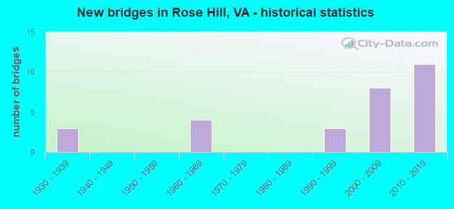
- New bridges - historical statistics
- 31930-1939
- 41960-1969
- 31990-1999
- 82000-2009
- 112010-2019
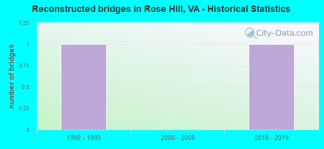
- Reconstructed bridges - Historical Statistics
- 11990-1999
- 02000-2009
- 12010-2019
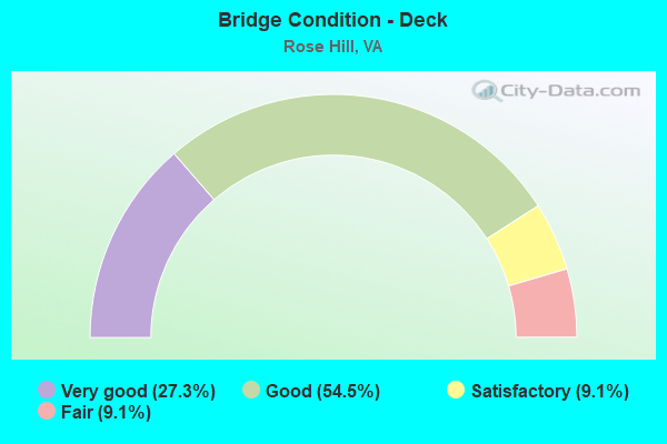
- Bridge Condition - Deck
- 27.3%Very good
- 54.5%Good
- 9.1%Satisfactory
- 9.1%Fair
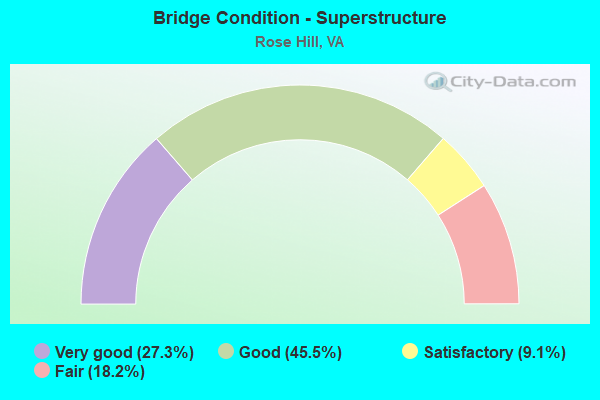
- Bridge Condition - Superstructure
- 27.3%Very good
- 45.5%Good
- 9.1%Satisfactory
- 18.2%Fair
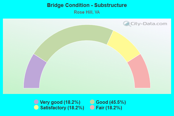
- Bridge Condition - Substructure
- 18.2%Very good
- 45.5%Good
- 18.2%Satisfactory
- 18.2%Fair
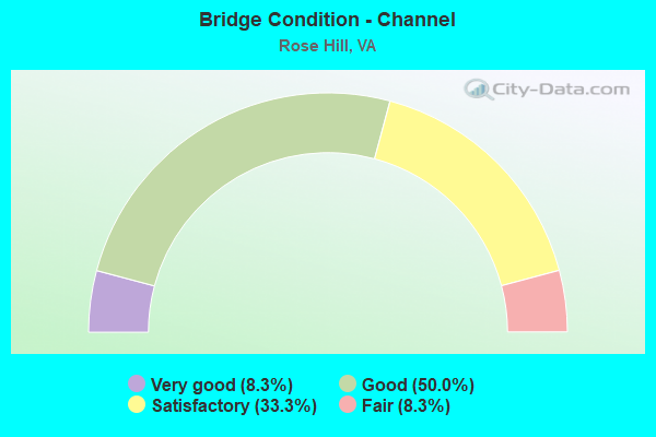
- Bridge Condition - Channel
- 8.3%Very good
- 50.0%Good
- 33.3%Satisfactory
- 8.3%Fair
Find on map >> Show street view
Structure Number: 668, Location: 00.03FR792/00.05TO1616 (Lat: 38.793314, Lng: -77.083586), Route carried "on" structure: County highway 611, Year Built: 1960, Status: Open, Structure Length: 1.95m (6.40ft), Average Daily Traffic: 27,586 (year 2020), Truck Traffic: 2%, Average Future Daily Traffic: 33,418 (year 2040), Design Load: HS 20, Features Intersected: PIKE BRANCH, Facility Carried by Structure: TELEGRAPH ROAD
Minimum Vertical Clearance: 30+ m (98+ ft), Kilometerpoint: 26.967, Lanes on structure: 4, Owner: State Highway Agency, Approaching Roadway Width: 8.5m (27.9ft), Skew: 4 degrees, Material/Design: Concrete, Design/Construction: Culvert, Number Of Spans In Main Unit: 5, Length of Maximum Span: 3.7m (12.1ft)
Condition: Channel: Fair, Culverts: Satisfactory, Operating Rating: 73.5 metric tons, Method Used To Determine Operating Rating: Load Factor (LF), Inventory Rating: 43.5 metric tons, Method Used To Determine Inventory Rating: Load Factor (LF), Structural Evaluation: Equal to present minimum criteria, Waterway Adequacy: Equal to present minimum criteria, Approach Roadway Alignment: Equal to present desirable criteria, Length Of Structure Improvement: 0.46m (1.51ft), Designated Inspection Frequency: Every 24 months, Inspection Date: Febuary 2021, Bridge Improvement Cost: $25,000, Roadway Improvement Cost: $20,000, Total Project Cost: $50,000 ( Estimate for 2015)
Find on map >> Show street view
Structure Number: 6937, Location: 00.17 1207 / 00.53 611 S. (Lat: 38.785275, Lng: -77.097972), Route carried "on" structure: County highway 1490, Year Built: 1992, Status: Open, Structure Length: 0.64m (2.10ft), Average Daily Traffic: 514 (year 2016), Average Future Daily Traffic: 598 (year 2040), Design Load: HS 20, Features Intersected: PIKE BRANCH, Facility Carried by Structure: OLD TELEGRAPH ROAD
Minimum Vertical Clearance: 30+ m (98+ ft), Kilometerpoint: 0.483, Lanes on structure: 2, Owner: State Highway Agency, Approaching Roadway Width: 6.1m (20.0ft), Material/Design: Concrete, Design/Construction: Culvert, Number Of Spans In Main Unit: 2, Length of Maximum Span: 2.4m (7.9ft)
Condition: Channel: Satisfactory, Culverts: Satisfactory, Operating Rating: 44.5 metric tons, Method Used To Determine Operating Rating: Load Factor (LF), Inventory Rating: 32.7 metric tons, Method Used To Determine Inventory Rating: Load Factor (LF), Structural Evaluation: Equal to present minimum criteria, Waterway Adequacy: Better than present minimum criteria, Approach Roadway Alignment: Somewhat better than minimum adequacy, Length Of Structure Improvement: 0.37m (1.21ft), Designated Inspection Frequency: Every 24 months, Inspection Date: July 2020, Bridge Improvement Cost: $1,000, Roadway Improvement Cost: $1,000, Total Project Cost: $3,000 ( Estimate for 2014)
Find on map >> Show street view
Structure Number: 107, Location: 0.09 FR T697;0.22 TO T672 (Lat: 36.675211, Lng: -83.360069), Route carried "on" structure: Business US 58, Year Built: 1930, Year Reconstructed: 2016, Status: Open, Structure Length: 0.99m (3.25ft), Average Daily Traffic: 1,242 (year 2020), Truck Traffic: 5%, Average Future Daily Traffic: 1,366 (year 2040), Design Load: HL 93, Features Intersected: POOR VALLEY BRANCH, Facility Carried by Structure: DR THOMAS WALKER R
Minimum Vertical Clearance: 30+ m (98+ ft), Kilometerpoint: 10.304, Lanes on structure: 2, Owner: State Highway Agency, Approaching Roadway Width: 6.9m (22.6ft), Material/Design: Concrete, Design/Construction: Slab, Number Of Spans In Main Unit: 1, Length of Maximum Span: 9.1m (29.9ft), Curb-To-Curb Width: 7.3m (24.0ft), Out-to-Out Width: 8.0m (26.2ft)
Condition: Deck: Very good, Superstructure: Very good, Substructure: Good, Channel: Good, Operating Rating: 79.8 metric tons, Method Used To Determine Operating Rating: Load and Resistance Factor (LRFR), Inventory Rating: 61.7 metric tons, Method Used To Determine Inventory Rating: Load and Resistance Factor (LRFR), Structural Evaluation: Better than present minimum criteria, Deck Geometry: Meets minimum limits, Waterway Adequacy: Better than present minimum criteria, Approach Roadway Alignment: Better than present minimum criteria, Designated Inspection Frequency: Every 24 months, Inspection Date: June 2020, Deck Structure Type: Concrete Cast-file-Place, Wearing Surface/Protective System: Deck Protection: Other
Find on map >> Show street view
Structure Number: 10733, Location: .04 BUS.58&.20 END MAIN. (Lat: 36.677789, Lng: -83.351733), Route carried "on" structure: County highway 906, Year Built: 1932, Year Reconstructed: 1995, Status: Open, Structure Length: 0.70m (2.30ft), Average Daily Traffic: 55 (year 2018), Average Future Daily Traffic: 79 (year 2040), Design Load: HS 20, Features Intersected: BRANCH, Facility Carried by Structure: Roy Crocket
Minimum Vertical Clearance: 30+ m (98+ ft), Kilometerpoint: 0.322, Lanes on structure: 2, Owner: State Highway Agency, Approaching Roadway Width: 10.4m (34.1ft), Material/Design: Concrete, Design/Construction: Slab, Number Of Spans In Main Unit: 1, Length of Maximum Span: 6.1m (20.0ft), Curb-To-Curb Width: 8.8m (28.9ft), Out-to-Out Width: 9.8m (32.2ft)
Condition: Deck: Fair, Superstructure: Fair, Substructure: Fair, Channel: Satisfactory, Operating Rating: 37.2 metric tons, Method Used To Determine Operating Rating: Load and Resistance Factor (LRFR), Inventory Rating: 29.0 metric tons, Method Used To Determine Inventory Rating: Load and Resistance Factor (LRFR), Structural Evaluation: Somewhat better than minimum adequacy, Deck Geometry: Better than present minimum criteria, Waterway Adequacy: Better than present minimum criteria, Approach Roadway Alignment: Better than present minimum criteria, Length Of Structure Improvement: 0.70m (2.30ft), Designated Inspection Frequency: Every 24 months, Inspection Date: June 2021, Bridge Improvement Cost: $62,000, Roadway Improvement Cost: $20,000, Total Project Cost: $169,000 ( Estimate for 2015), Deck Structure Type: Concrete Cast-file-Place
Find on map >> Show street view
Structure Number: 10906, Location: .35 TO 697 - 1.05 TO 671 (Lat: 36.670247, Lng: -83.357700), Route carried "on" structure: County highway 672, Year Built: 1932, Status: Posted for load, Structure Length: 1.13m (3.71ft), Average Daily Traffic: 434 (year 2018), Average Future Daily Traffic: 482 (year 2040), Design Load: HS 20, Features Intersected: MARTIN CREEK
Minimum Vertical Clearance: 30+ m (98+ ft), Kilometerpoint: 9.562, Lanes on structure: 1, Owner: State Highway Agency, Approaching Roadway Width: 6.7m (22.0ft), Skew: 4 degrees, Material/Design: Steel, Design/Construction: Stringer/Multi-beam, Number Of Spans In Main Unit: 1, Length of Maximum Span: 11.3m (37.1ft), Curb-To-Curb Width: 4.9m (16.1ft), Out-to-Out Width: 5.5m (18.0ft)
Condition: Deck: Good, Superstructure: Fair, Substructure: Satisfactory, Channel: Very good, Operating Rating: 24.5 metric tons, Method Used To Determine Operating Rating: Load Factor (LF), Inventory Rating: 14.5 metric tons, Method Used To Determine Inventory Rating: Load Factor (LF), Structural Evaluation: Meets minimum limits, Deck Geometry: High priority of replacement, Waterway Adequacy: Better than present minimum criteria, Approach Roadway Alignment: Better than present minimum criteria, Bridge Posting: Required (Relationship of Operating Rating to Maximum Legal Load: 30.0 - 39.9% below), Length Of Structure Improvement: 1.13m (3.71ft), Designated Inspection Frequency: Every 24 months, Inspection Date: March 2021, Bridge Improvement Cost: $20,000, Roadway Improvement Cost: $5,000, Total Project Cost: $33,000 ( Estimate for 2036), Deck Structure Type: Wood or Timber, Wearing Surface/Protective System: Wearing Surface: Bituminous
Find on map >> Show street view
Structure Number: 12015, Location: 2.8 FR 660 & 1.0 TO 675 (Lat: 36.731808, Lng: -78.323158), Route carried "on" structure: County highway 671, Year Built: 1962, Status: Open, Structure Length: 1.51m (4.95ft), Average Daily Traffic: 126 (year 2020), Truck Traffic: 3%, Average Future Daily Traffic: 139 (year 2040), Design Load: H 20, Features Intersected: LAYTON CREEK, Facility Carried by Structure: STONY CROSS ROAD
Minimum Vertical Clearance: 30+ m (98+ ft), Kilometerpoint: 16.478, Lanes on structure: 2, Owner: State Highway Agency, Approaching Roadway Width: 7.9m (25.9ft), Material/Design: Concrete, Design/Construction: Tee Beam, Number Of Spans In Main Unit: 1, Length of Maximum Span: 14.5m (47.6ft), Curb or Sidewalk Widths: Left: 0.7m (2.3ft), Right: 0.7m (2.3ft), Curb-To-Curb Width: 7.3m (24.0ft), Out-to-Out Width: 8.8m (28.9ft)
Condition: Deck: Good, Superstructure: Good, Substructure: Fair, Channel: Good, Operating Rating: 49.9 metric tons, Method Used To Determine Operating Rating: Load and Resistance Factor (LRFR), Inventory Rating: 39.0 metric tons, Method Used To Determine Inventory Rating: Load and Resistance Factor (LRFR), Structural Evaluation: Somewhat better than minimum adequacy, Deck Geometry: Somewhat better than minimum adequacy, Waterway Adequacy: Better than present minimum criteria, Approach Roadway Alignment: Equal to present desirable criteria, Length Of Structure Improvement: 1.52m (4.99ft), Designated Inspection Frequency: Every 24 months, Inspection Date: August 2021, Bridge Improvement Cost: $600,000, Roadway Improvement Cost: $100,000, Total Project Cost: $711,000 ( Estimate for 2015), Deck Structure Type: Concrete Cast-file-Place
Find on map >> Show street view
Structure Number: 23972, Location: 0.44 FR RT 819-0.00TO672 (Lat: 36.658961, Lng: -83.357547), Route carried "on" structure: County highway 671, Year Built: 1994, Status: Open, Structure Length: 1.19m (3.90ft), Average Daily Traffic: 365 (year 2018), Average Future Daily Traffic: 395 (year 2040), Design Load: HS 20+Mod, Features Intersected: MARTIN CREEK, Facility Carried by Structure: Balls Chapel Road
Minimum Vertical Clearance: 30+ m (98+ ft), Kilometerpoint: 3.701, Lanes on structure: 2, Owner: State Highway Agency, Approaching Roadway Width: 9.1m (29.9ft), Material/Design: Steel, Design/Construction: Stringer/Multi-beam, Number Of Spans In Main Unit: 1, Length of Maximum Span: 11.2m (36.7ft), Curb-To-Curb Width: 7.6m (24.9ft), Out-to-Out Width: 7.7m (25.3ft)
Condition: Deck: Satisfactory, Superstructure: Satisfactory, Substructure: Satisfactory, Channel: Good, Operating Rating: 55.3 metric tons, Method Used To Determine Operating Rating: Load Factor (LF), Inventory Rating: 32.7 metric tons, Method Used To Determine Inventory Rating: Load Factor (LF), Structural Evaluation: Equal to present minimum criteria, Waterway Adequacy: Better than present minimum criteria, Approach Roadway Alignment: Better than present minimum criteria, Designated Inspection Frequency: Every 24 months, Inspection Date: July 2020, Deck Structure Type: Wood or Timber
Find on map >> Show street view
Structure Number: 26439, Location: 02.87FR0613/00.20TO0241 (Lat: 38.800911, Lng: -77.084486), Route carried "on" structure: Interstate 95, Year Built: 2010, Status: Open, Structure Length: 10.47m (34.35ft), Average Daily Traffic: 207,460 (year 2020), Truck Traffic: 6%, Average Future Daily Traffic: 228,206 (year 2040), Design Load: HS 20, Features Intersected: CAMERON RUN, Facility Carried by Structure: Capital Beltway
Minimum Vertical Clearance: 30+ m (98+ ft), Kilometerpoint: 0.000, Lanes on structure: 14, Base Highway Network: Yes, Owner: State Highway Agency, Approaching Roadway Width: 13.4m (44.0ft), Material/Design: Prestressed concrete continuous, Design/Construction: Stringer/Multi-beam, Number Of Spans In Main Unit: 3, Length of Maximum Span: 34.7m (113.8ft), Curb-To-Curb Width: 10.1m (33.1ft), Out-to-Out Width: 86.7m (284.4ft)
Condition: Deck: Good, Superstructure: Good, Substructure: Good, Channel: Good, Operating Rating: 71.8 metric tons, Method Used To Determine Operating Rating: Load and Resistance Factor (LRFR), Inventory Rating: 55.4 metric tons, Method Used To Determine Inventory Rating: Load and Resistance Factor (LRFR), Structural Evaluation: Better than present minimum criteria, Deck Geometry: High priority of replacement, Waterway Adequacy: Equal to present desirable criteria, Approach Roadway Alignment: Equal to present desirable criteria, Length Of Structure Improvement: 0.30m (0.98ft), Designated Inspection Frequency: Every 24 months, Inspection Date: August 2020, Bridge Improvement Cost: $100,000, Roadway Improvement Cost: $100,000, Total Project Cost: $250,000, Deck Structure Type: Concrete Cast-file-Place, Wearing Surface/Protective System: Wearing Surface: Monolithic Concrete, Deck Protection: Epoxy Coated Reinforcing
Find on map >> Show street view
Structure Number: 26442, Location: 00.00FR1332/00.63TO0236 (Lat: 38.798811, Lng: -77.079539), Route carried "on" structure: State highway 241, Year Built: 2011, Status: Open, Structure Length: 7.42m (24.34ft), Average Daily Traffic: 46,288 (year 2020), Truck Traffic: 3%, Average Future Daily Traffic: 64,803 (year 2040), Design Load: HS 20, Features Intersected: CAMERON RUN, Facility Carried by Structure: TELEGRAPH ROAD
Minimum Vertical Clearance: 30+ m (98+ ft), Kilometerpoint: 0.000, Lanes on structure: 9, Owner: State Highway Agency, Approaching Roadway Width: 36.6m (120.1ft), Skew: 12 degrees, Material/Design: Prestressed concrete, Design/Construction: Stringer/Multi-beam, Number Of Spans In Main Unit: 3, Length of Maximum Span: 27.4m (89.9ft), Curb or Sidewalk Widths: Left: 4.9m (16.1ft), Right: 3.7m (12.1ft), Curb-To-Curb Width: 30.5m (100.1ft), Out-to-Out Width: 46.2m (151.6ft)
Condition: Deck: Good, Superstructure: Good, Substructure: Good, Channel: Good, Operating Rating: 62.9 metric tons, Method Used To Determine Operating Rating: Load and Resistance Factor (LRFR), Inventory Rating: 48.5 metric tons, Method Used To Determine Inventory Rating: Load and Resistance Factor (LRFR), Structural Evaluation: Better than present minimum criteria, Deck Geometry: High priority of replacement, Approach Roadway Alignment: Equal to present desirable criteria, Length Of Structure Improvement: 1.52m (4.99ft), Designated Inspection Frequency: Every 24 months, Inspection Date: May 2021, Bridge Improvement Cost: $100,000, Roadway Improvement Cost: $100,000, Total Project Cost: $202,000, Deck Structure Type: Concrete Cast-file-Place, Wearing Surface/Protective System: Wearing Surface: Integral Concrete, Deck Protection: Epoxy Coated Reinforcing
Find on map >> Show street view
Structure Number: 26443, Location: 00.20fr95 00.40to241 (Lat: 38.799950, Lng: -77.080431), Route carried "on" structure: Ramp Interstate 95, Year Built: 2010, Status: Open, Structure Length: 49.53m (162.50ft), Average Daily Traffic: 9,347 (year 2020), Truck Traffic: 6%, Average Future Daily Traffic: 13,086 (year 2040), Design Load: HS 20, Features Intersected: RMP.E;L;I-95 & RTE.241, Facility Carried by Structure: RMP.A #2069
Minimum Vertical Clearance: 30+ m (98+ ft), Kilometerpoint: 0.000, Lanes on structure: 2, Lanes under structure: 22, Base Highway Network: Yes, Owner: State Highway Agency, Approaching Roadway Width: 12.2m (40.0ft), Material/Design: Steel continuous, Design/Construction: Stringer/Multi-beam, Number Of Spans In Main Unit: 12, Length of Maximum Span: 59.4m (194.9ft), Curb-To-Curb Width: 10.1m (33.1ft), Out-to-Out Width: 12.2m (40.0ft)
Condition: Deck: Good, Superstructure: Good, Substructure: Good, Operating Rating: 43.5 metric tons, Method Used To Determine Operating Rating: Load and Resistance Factor (LRFR), Inventory Rating: 33.3 metric tons, Method Used To Determine Inventory Rating: Load and Resistance Factor (LRFR), Structural Evaluation: Better than present minimum criteria, Deck Geometry: Equal to present minimum criteria, Underclear: High priority of corrective action, Approach Roadway Alignment: Better than present minimum criteria, Length Of Structure Improvement: 0.30m (0.98ft), Designated Inspection Frequency: Every 24 months, Inspection Date: October 2020, Bridge Improvement Cost: $1,000, Roadway Improvement Cost: $1,000, Total Project Cost: $3,000 ( Estimate for 2015), Deck Structure Type: Concrete Cast-file-Place, Wearing Surface/Protective System: Deck Protection: Epoxy Coated Reinforcing
Find on map >> Show street view
Structure Number: 28162, Location: 00.03FR611/00.01TO BURGUN (Lat: 38.798781, Lng: -77.080953), Route carried "on" structure: Alternate County highway 1464, Year Built: 2007, Status: Open, Structure Length: 0.98m (3.22ft), Average Daily Traffic: 8,493 (year 2015), Truck Traffic: 1%, Average Future Daily Traffic: 12,630 (year 2040), Design Load: HS 20, Features Intersected: PIKE BRANCH, Facility Carried by Structure: RAMPS H3;4&EAST DR
Minimum Vertical Clearance: 30+ m (98+ ft), Kilometerpoint: 0.000, Lanes on structure: 4, Base Highway Network: Yes, Owner: State Highway Agency, Approaching Roadway Width: 30.2m (99.1ft), Skew: 1 degrees, Material/Design: Concrete, Design/Construction: Culvert, Number Of Spans In Main Unit: 3, Length of Maximum Span: 3.0m (9.8ft)
Condition: Channel: Satisfactory, Culverts: Satisfactory, Operating Rating: 68.0 metric tons, Method Used To Determine Operating Rating: Load Factor (LF), Inventory Rating: 40.8 metric tons, Method Used To Determine Inventory Rating: Load Factor (LF), Structural Evaluation: Equal to present minimum criteria, Waterway Adequacy: Equal to present desirable criteria, Approach Roadway Alignment: Better than present minimum criteria, Length Of Structure Improvement: 45.81m (150.30ft), Designated Inspection Frequency: Every 24 months, Inspection Date: May 2021, Bridge Improvement Cost: $55,000, Roadway Improvement Cost: $77,000, Total Project Cost: $150,000
Find on map >> Show street view
Structure Number: 28278, Location: 00.42FR95/00.15TO HUNTIN (Lat: 38.798403, Lng: -77.080431), Route carried "on" structure: Ramp Interstate 95, Year Built: 2009, Status: Open, Structure Length: 5.06m (16.60ft), Average Daily Traffic: 14,000 (year 2009), Truck Traffic: 3%, Average Future Daily Traffic: 23,000 (year 2029), Design Load: HS 20, Features Intersected: TELEGRAPH RD. RTE.241, Facility Carried by Structure: RAMP H-2
Minimum Vertical Clearance: 30+ m (98+ ft), Kilometerpoint: 0.000, Lanes on structure: 2, Lanes under structure: 8, Base Highway Network: Yes, Owner: State Highway Agency, Approaching Roadway Width: 9.8m (32.2ft), Material/Design: Steel, Design/Construction: Stringer/Multi-beam, Number Of Spans In Main Unit: 1, Length of Maximum Span: 49.7m (163.1ft), Curb-To-Curb Width: 9.8m (32.2ft), Out-to-Out Width: 10.7m (35.1ft)
Condition: Deck: Very good, Superstructure: Very good, Substructure: Very good, Operating Rating: 53.9 metric tons, Method Used To Determine Operating Rating: Load and Resistance Factor (LRFR), Inventory Rating: 41.5 metric tons, Method Used To Determine Inventory Rating: Load and Resistance Factor (LRFR), Structural Evaluation: Equal to present desirable criteria, Deck Geometry: Equal to present minimum criteria, Underclear: Equal to present minimum criteria, Approach Roadway Alignment: Equal to present desirable criteria, Designated Inspection Frequency: Every 24 months, Inspection Date: May 2021, Deck Structure Type: Concrete Cast-file-Place, Wearing Surface/Protective System: Wearing Surface: Monolithic Concrete, Deck Protection: Epoxy Coated Reinforcing
Find on map >> Show street view
Structure Number: 28279, Location: 00.30FRI95/00.20TO1330HUN (Lat: 38.798878, Lng: -77.081589), Route carried "on" structure: Ramp Interstate 95, Year Built: 2009, Status: Open, Structure Length: 2.74m (8.99ft), Average Daily Traffic: 72,045 (year 2018), Truck Traffic: 6%, Average Future Daily Traffic: 23,000 (year 2029), Design Load: HS 20, Features Intersected: RAMP H-4, Facility Carried by Structure: RAMP H-2
Minimum Vertical Clearance: 30+ m (98+ ft), Kilometerpoint: 0.000, Lanes on structure: 2, Lanes under structure: 8, Base Highway Network: Yes, Owner: State Highway Agency, Approaching Roadway Width: 7.3m (24.0ft), Skew: 3 degrees, Material/Design: Steel, Design/Construction: Stringer/Multi-beam, Number Of Spans In Main Unit: 1, Length of Maximum Span: 26.2m (86.0ft), Curb-To-Curb Width: 7.3m (24.0ft), Out-to-Out Width: 8.4m (27.6ft)
Condition: Deck: Very good, Superstructure: Very good, Substructure: Very good, Operating Rating: 42.8 metric tons, Method Used To Determine Operating Rating: Load and Resistance Factor (LRFR), Inventory Rating: 33.0 metric tons, Method Used To Determine Inventory Rating: Load and Resistance Factor (LRFR), Structural Evaluation: Equal to present desirable criteria, Deck Geometry: High priority of replacement, Underclear: Meets minimum limits, Approach Roadway Alignment: Equal to present desirable criteria, Designated Inspection Frequency: Every 24 months, Inspection Date: April 2021, Deck Structure Type: Concrete Cast-file-Place, Wearing Surface/Protective System: Wearing Surface: Monolithic Concrete, Deck Protection: Epoxy Coated Reinforcing
Find on map >> Show street view
Structure Number: 2828, Location: 00.40FRI95/00.20TOKINGS H (Lat: 38.797789, Lng: -77.081053), Route carried "on" structure: Ramp Interstate 95, Year Built: 2009, Status: Open, Structure Length: 5.52m (18.11ft), Average Daily Traffic: 14,000 (year 2009), Truck Traffic: 3%, Average Future Daily Traffic: 23,000 (year 2029), Design Load: HS 20, Features Intersected: RT 241 - TELEGRAPH RD, Facility Carried by Structure: RAMP H-3
Minimum Vertical Clearance: 30+ m (98+ ft), Kilometerpoint: 0.000, Lanes on structure: 2, Lanes under structure: 8, Base Highway Network: Yes, Owner: State Highway Agency, Approaching Roadway Width: 9.8m (32.2ft), Material/Design: Steel, Design/Construction: Stringer/Multi-beam, Number Of Spans In Main Unit: 1, Length of Maximum Span: 54.6m (179.1ft), Curb-To-Curb Width: 9.8m (32.2ft), Out-to-Out Width: 10.7m (35.1ft)
Condition: Deck: Good, Superstructure: Good, Substructure: Good, Operating Rating: 56.0 metric tons, Method Used To Determine Operating Rating: Load and Resistance Factor (LRFR), Inventory Rating: 43.2 metric tons, Method Used To Determine Inventory Rating: Load and Resistance Factor (LRFR), Structural Evaluation: Better than present minimum criteria, Deck Geometry: Equal to present minimum criteria, Underclear: Somewhat better than minimum adequacy, Approach Roadway Alignment: Equal to present desirable criteria, Designated Inspection Frequency: Every 24 months, Inspection Date: April 2021, Deck Structure Type: Concrete Cast-file-Place, Wearing Surface/Protective System: Wearing Surface: Monolithic Concrete, Deck Protection: Epoxy Coated Reinforcing
Find on map >> Show street view
Structure Number: 2919, Location: 00.20FR0095/00.40TO0611 (Lat: 38.800531, Lng: -77.084458), Route carried "on" structure: Ramp Interstate 95, Year Built: 2009, Status: Open, Structure Length: 0.64m (2.10ft), Average Daily Traffic: 7,787 (year 2020), Truck Traffic: 2%, Average Future Daily Traffic: 10,902 (year 2040), Design Load: HS 20, Features Intersected: TRIB OF PIKE BRANCH
Minimum Vertical Clearance: 30+ m (98+ ft), Kilometerpoint: 0.000, Lanes on structure: 2, Base Highway Network: Yes, Owner: State Highway Agency, Approaching Roadway Width: 11.0m (36.1ft), Material/Design: Concrete, Design/Construction: Culvert, Number Of Spans In Main Unit: 3, Length of Maximum Span: 1.8m (5.9ft)
Condition: Channel: Good, Culverts: Satisfactory, Inventory Rating: 88.9 metric tons, Method Used To Determine Inventory Rating: Load Factor (LF), Structural Evaluation: Equal to present minimum criteria, Waterway Adequacy: Equal to present desirable criteria, Approach Roadway Alignment: Equal to present desirable criteria, Length Of Structure Improvement: 11.98m (39.30ft), Designated Inspection Frequency: Every 24 months, Inspection Date: May 2021, Bridge Improvement Cost: $33,000, Roadway Improvement Cost: $66,000, Total Project Cost: $150,000 ( Estimate for 2015)
Find on map >> Show street view
Structure Number: 29579, Location: 0.4M to 907; 0.9M ALT 58 (Lat: 36.661111, Lng: -83.390278), Route carried "on" structure: US 58, Year Built: 1996, Status: Open, Structure Length: 0.66m (2.17ft), Average Daily Traffic: 3,077 (year 2020), Truck Traffic: 5%, Average Future Daily Traffic: 3,385 (year 2040), Design Load: HS 20+Mod, Features Intersected: Stream
Minimum Vertical Clearance: 30+ m (98+ ft), Kilometerpoint: 0.000, Lanes on structure: 4, Base Highway Network: Yes, Owner: State Highway Agency, Approaching Roadway Width: 11.0m (36.1ft), Skew: 13 degrees, Material/Design: Concrete, Design/Construction: Culvert, Number Of Spans In Main Unit: 2, Length of Maximum Span: 3.2m (10.5ft)
Condition: Channel: Satisfactory, Culverts: Satisfactory, Operating Rating: 44.5 metric tons, Method Used To Determine Operating Rating: Field evaluation and documented engineering judgment, Inventory Rating: 32.7 metric tons, Method Used To Determine Inventory Rating: Field evaluation and documented engineering judgment, Structural Evaluation: Equal to present minimum criteria, Waterway Adequacy: Equal to present minimum criteria, Approach Roadway Alignment: Better than present minimum criteria, Designated Inspection Frequency: Every 24 months, Inspection Date: October 2021
Find on map >> Show street view
Structure Number: 6409, Location: 01.88FR241/1.50TO613 (Lat: 38.801514, Lng: -77.112161), Route carried "under" structure: County highway 1148, Year Built: 1963, Structure Length: 0. m, Average Daily Traffic: 557 (year 2008), Truck Traffic: 1%, Features Intersected: EISENHOWER CONN. 1148, Facility Carried by Structure: 95 CAPITAL BELTWAY
Minimum Vertical Clearance: 5.18m (16.99ft), Kilometerpoint: 0.193, Lanes on structure: 8, Lanes under structure: 3, Material/Design: Prestressed concrete, Design/Construction: Stringer/Multi-beam, Length of Maximum Span: 14.0m (45.9ft)
Find on map >> Show street view
Structure Number: 6409, Location: 01.88FR241/1.50TO613 (Lat: 38.801514, Lng: -77.112161), Route carried "under" structure: County highway 1148, Year Built: 1963, Structure Length: 0. m, Average Daily Traffic: 557 (year 2008), Truck Traffic: 1%, Features Intersected: EISENHOWER CONN. 1148, Facility Carried by Structure: 95 CAPITAL BELTWAY
Minimum Vertical Clearance: 5.05m (16.57ft), Kilometerpoint: 0.193, Lanes on structure: 8, Lanes under structure: 3, Material/Design: Prestressed concrete, Design/Construction: Stringer/Multi-beam, Length of Maximum Span: 14.0m (45.9ft)
Find on map >> Show street view
Structure Number: 26443, Location: 00.20fr95 00.40to241 (Lat: 38.799950, Lng: -77.080431), Route carried "under" structure: Ramp County highway 241, Year Built: 2010, Structure Length: 0. m, Average Daily Traffic: 28,000 (year 2010), Truck Traffic: 2%, Features Intersected: RMP.E;L;I-95 & RTE.241, Facility Carried by Structure: RMP.A #2069
Minimum Vertical Clearance: 5.72m (18.77ft), Kilometerpoint: 0.000, Lanes on structure: 2, Lanes under structure: 1, Material/Design: Steel continuous, Design/Construction: Stringer/Multi-beam, Length of Maximum Span: 59.4m (194.9ft)
Find on map >> Show street view
Structure Number: 26443, Location: 00.20fr95 00.40to241 (Lat: 38.799950, Lng: -77.080431), Route carried "under" structure: Ramp County highway 95, Year Built: 2010, Structure Length: 0. m, Average Daily Traffic: 18,000 (year 2010), Truck Traffic: 6%, Features Intersected: RMP.E;L;I-95 & RTE.241, Facility Carried by Structure: RMP.A #2069
Minimum Vertical Clearance: 6.32m (20.73ft), Kilometerpoint: 0.000, Lanes on structure: 2, Lanes under structure: 1, Material/Design: Steel continuous, Design/Construction: Stringer/Multi-beam, Length of Maximum Span: 59.4m (194.9ft)
Find on map >> Show street view
Structure Number: 26443, Location: 00.20fr95 00.40to241 (Lat: 38.799950, Lng: -77.080431), Route carried "under" structure: Interstate 495, Year Built: 2010, Structure Length: 0. m, Average Daily Traffic: 45,000 (year 2010), Truck Traffic: 8%, Features Intersected: RMP.E;L;I-95 & RTE.241, Facility Carried by Structure: RMP.A #2069
Minimum Vertical Clearance: 5.87m (19.26ft), Kilometerpoint: 0.000, Lanes on structure: 2, Lanes under structure: 3, Material/Design: Steel continuous, Design/Construction: Stringer/Multi-beam, Length of Maximum Span: 59.4m (194.9ft)
Find on map >> Show street view
Structure Number: 26443, Location: 00.20fr95 00.40to241 (Lat: 38.799950, Lng: -77.080431), Route carried "under" structure: Interstate 495, Year Built: 2010, Structure Length: 0. m, Average Daily Traffic: 82,000 (year 2010), Truck Traffic: 10%, Features Intersected: RMP.E;L;I-95 & RTE.241, Facility Carried by Structure: RMP.A #2069
Minimum Vertical Clearance: 6.07m (19.91ft), Kilometerpoint: 0.000, Lanes on structure: 2, Lanes under structure: 2, Material/Design: Steel continuous, Design/Construction: Stringer/Multi-beam, Length of Maximum Span: 59.4m (194.9ft)
Find on map >> Show street view
Structure Number: 26443, Location: 00.20fr95 00.40to241 (Lat: 38.799950, Lng: -77.080431), Route carried "under" structure: Interstate 495, Year Built: 2010, Structure Length: 0. m, Average Daily Traffic: 80,000 (year 2010), Truck Traffic: 9%, Features Intersected: RMP.E;L;I-95 & RTE.241, Facility Carried by Structure: RMP.A #2069
Minimum Vertical Clearance: 6.50m (21.33ft), Kilometerpoint: 0.000, Lanes on structure: 2, Lanes under structure: 2, Material/Design: Steel continuous, Design/Construction: Stringer/Multi-beam, Length of Maximum Span: 59.4m (194.9ft)
Find on map >> Show street view
Structure Number: 26443, Location: 00.20fr95 00.40to241 (Lat: 38.799950, Lng: -77.080431), Route carried "under" structure: County highway 241, Year Built: 2010, Structure Length: 0. m, Average Daily Traffic: 38,000 (year 2010), Truck Traffic: 4%, Features Intersected: RMP.E;L;I-95 & RTE.241, Facility Carried by Structure: RMP.A #2069
Minimum Vertical Clearance: 11.05m (36.25ft), Kilometerpoint: 0.000, Lanes on structure: 2, Lanes under structure: 8, Material/Design: Steel continuous, Design/Construction: Stringer/Multi-beam, Length of Maximum Span: 59.4m (194.9ft)
Find on map >> Show street view
Structure Number: 26443, Location: 00.20fr95 00.40to241 (Lat: 38.799950, Lng: -77.080431), Route carried "under" structure: Ramp County highway 95, Year Built: 2010, Structure Length: 0. m, Average Daily Traffic: 18,000 (year 2010), Truck Traffic: 6%, Features Intersected: RMP.E;L;I-95 & RTE.241, Facility Carried by Structure: RMP.A #2069
Minimum Vertical Clearance: 7.11m (23.33ft), Kilometerpoint: 0.000, Lanes on structure: 2, Lanes under structure: 1, Material/Design: Steel continuous, Design/Construction: Stringer/Multi-beam, Length of Maximum Span: 59.4m (194.9ft)
Find on map >> Show street view
Structure Number: 26443, Location: 00.20fr95 00.40to241 (Lat: 38.799950, Lng: -77.080431), Route carried "under" structure: Interstate 495, Year Built: 2010, Structure Length: 0. m, Average Daily Traffic: 78,000 (year 2010), Truck Traffic: 8%, Features Intersected: RMP.E;L;I-95 & RTE.241, Facility Carried by Structure: RMP.A #2069
Minimum Vertical Clearance: 6.35m (20.83ft), Kilometerpoint: 0.000, Lanes on structure: 2, Lanes under structure: 2, Material/Design: Steel continuous, Design/Construction: Stringer/Multi-beam, Length of Maximum Span: 59.4m (194.9ft)
Find on map >> Show street view
Structure Number: 28278, Location: 00.42FR95/00.15TO HUNTIN (Lat: 38.798403, Lng: -77.080431), Route carried "under" structure: County highway 241, Year Built: 2009, Structure Length: 0. m, Average Daily Traffic: 20,000 (year 2011), Features Intersected: TELEGRAPH RD. RTE.241, Facility Carried by Structure: RAMP H-2
Minimum Vertical Clearance: 6.17m (20.24ft), Kilometerpoint: 0.000, Lanes on structure: 2, Lanes under structure: 8, Material/Design: Steel, Design/Construction: Stringer/Multi-beam, Length of Maximum Span: 49.7m (163.1ft)
Find on map >> Show street view
Structure Number: 28279, Location: 00.30FRI95/00.20TO1330HUN (Lat: 38.798878, Lng: -77.081589), Route carried "under" structure: State highway 241, Year Built: 2009, Structure Length: 0. m, Average Daily Traffic: 14,000 (year 2009), Truck Traffic: 3%, Features Intersected: RAMP H-4, Facility Carried by Structure: RAMP H-2
Minimum Vertical Clearance: 6.40m (21.00ft), Kilometerpoint: 0.000, Lanes on structure: 2, Lanes under structure: 8, Material/Design: Steel, Design/Construction: Stringer/Multi-beam, Length of Maximum Span: 26.2m (86.0ft)
Find on map >> Show street view
Structure Number: 2828, Location: 00.40FRI95/00.20TOKINGS H (Lat: 38.797789, Lng: -77.081053), Route carried "under" structure: State highway 241, Year Built: 2009, Structure Length: 0. m, Average Daily Traffic: 14,000 (year 2011), Features Intersected: RT 241 - TELEGRAPH RD, Facility Carried by Structure: RAMP H-3
Minimum Vertical Clearance: 4.98m (16.34ft), Kilometerpoint: 0.000, Lanes on structure: 2, Lanes under structure: 8, Material/Design: Steel, Design/Construction: Stringer/Multi-beam, Length of Maximum Span: 54.6m (179.1ft)