Bridge Statistics for Round Rock, Texas (TX)
Condition, Traffic, Stress, Structural Evaluation, Project Costs
- National Bridge Inventory (NBI) Statistics
- 220Number of bridges
- 5,725ft / 1,745mTotal length
- $1,020,000Total costs
- 6,423,617Total average daily traffic
- 610,071Total average daily truck traffic
- National Bridge Inventory (NBI) Registered Bridges for Round Rock
- No street view available for this location
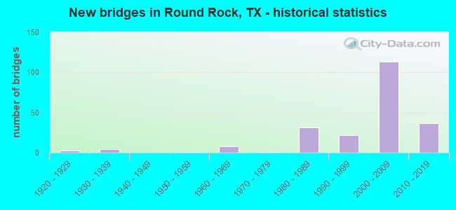
- New bridges - historical statistics
- 31920-1929
- 41930-1939
- 11950-1959
- 81960-1969
- 11970-1979
- 311980-1989
- 221990-1999
- 1132000-2009
- 372010-2019
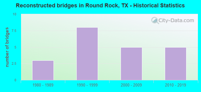
- Reconstructed bridges - Historical Statistics
- 31980-1989
- 81990-1999
- 52000-2009
- 52010-2019
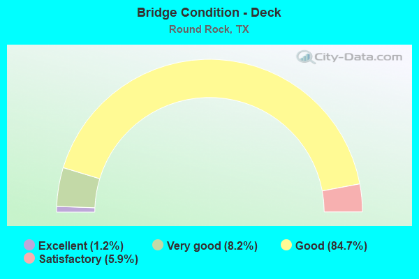
- Bridge Condition - Deck
- 1.2%Excellent
- 8.2%Very good
- 84.7%Good
- 5.9%Satisfactory
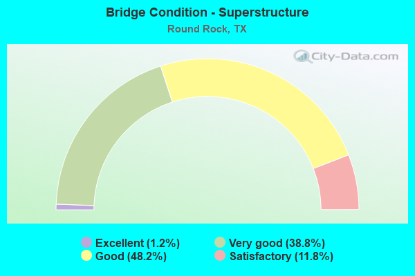
- Bridge Condition - Superstructure
- 1.2%Excellent
- 38.8%Very good
- 48.2%Good
- 11.8%Satisfactory
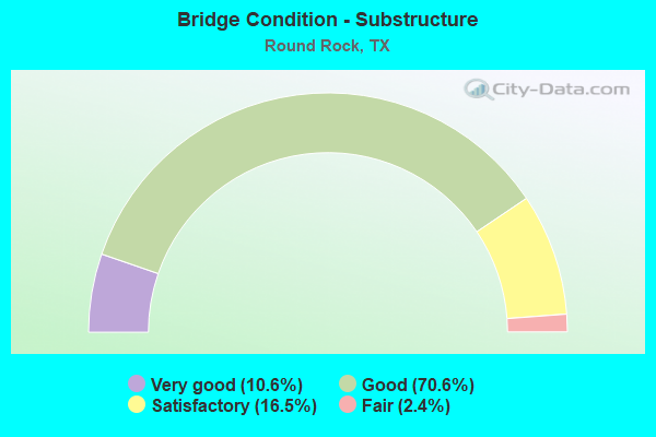
- Bridge Condition - Substructure
- 10.6%Very good
- 70.6%Good
- 16.5%Satisfactory
- 2.4%Fair
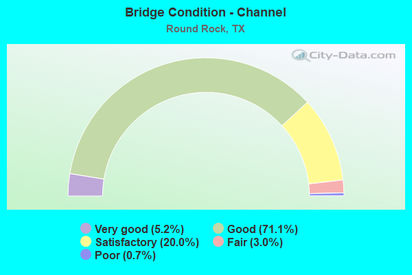
- Bridge Condition - Channel
- 5.2%Very good
- 71.1%Good
- 20.0%Satisfactory
- 3.0%Fair
- 0.7%Poor
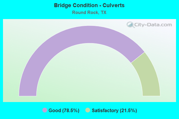
- Bridge Condition - Culverts
- 78.5%Good
- 21.5%Satisfactory
Find on map >> Show street view
Structure Number: 142270E01170001, Location: 0.15 MI E OF IH 35 (Lat: 30.474569, Lng: -97.665647), Route carried "on" structure: City street , Year Built: 2003, Status: Open, Structure Length: 1.83m (6.00ft), Average Daily Traffic: 9,130 (year 2010), Truck Traffic: 2%, Average Future Daily Traffic: 16,500 (year 2030), Features Intersected: GILLELAND CREEK, Facility Carried by Structure: GREENLAWN BLVD
Minimum Vertical Clearance: 30+ m (98+ ft), Kilometerpoint: 0.966, Lanes on structure: 4, Owner: City or Municipal Highway Agency, Approaching Roadway Width: 18.3m (60.0ft), Skew: 1 degrees, Material/Design: Concrete, Design/Construction: Culvert, Number Of Spans In Main Unit: 6, Length of Maximum Span: 2.7m (8.9ft), Curb or Sidewalk Widths: Left: 2.4m (7.9ft), Right: 2.4m (7.9ft)
Condition: Channel: Satisfactory, Culverts: Good, Operating Rating: 32.7 metric tons, Method Used To Determine Operating Rating: Field evaluation and documented engineering judgment, Inventory Rating: 24.5 metric tons, Method Used To Determine Inventory Rating: Field evaluation and documented engineering judgment, Structural Evaluation: Equal to present minimum criteria, Waterway Adequacy: Equal to present minimum criteria, Approach Roadway Alignment: Equal to present desirable criteria, Designated Inspection Frequency: Every 24 months, Inspection Date: December 2021
Find on map >> Show street view
Structure Number: 142460001509176, Location: 0.86 MI S OF FM 3406 (Lat: 30.523556, Lng: -97.689494), Route carried "on" structure: Interstate 35, Year Built: 1960, Year Reconstructed: 2006, Status: Open, Structure Length: 3.26m (10.70ft), Average Daily Traffic: 138,115 (year 2019), Truck Traffic: 12%, Average Future Daily Traffic: 193,361 (year 2039), Design Load: HS 20, Features Intersected: ONION BRANCH
Minimum Vertical Clearance: 30+ m (98+ ft), Kilometerpoint: 5.032, Lanes on structure: 12, Base Highway Network: Yes, Owner: State Highway Agency, Approaching Roadway Width: 58.5m (191.9ft), Skew: 34 degrees, Material/Design: Concrete, Design/Construction: Culvert, Number Of Spans In Main Unit: 7, Length of Maximum Span: 3.0m (9.8ft)
Condition: Channel: Satisfactory, Culverts: Satisfactory, Operating Rating: 39.9 metric tons, Method Used To Determine Operating Rating: Load Factor (LF), Inventory Rating: 23.6 metric tons, Method Used To Determine Inventory Rating: Load Factor (LF), Structural Evaluation: Somewhat better than minimum adequacy, Waterway Adequacy: Equal to present minimum criteria, Approach Roadway Alignment: Equal to present desirable criteria, Designated Inspection Frequency: Every 24 months, Inspection Date: January 2021
Find on map >> Show street view
Structure Number: 142460001509177, Location: 0.5 MI N OF FM 620 (Lat: 30.517203, Lng: -97.687983), Route carried "on" structure: Interstate 35, Year Built: 1960, Year Reconstructed: 1990, Status: Open, Structure Length: 8.53m (27.99ft), Average Daily Traffic: 138,115 (year 2019), Truck Traffic: 12%, Average Future Daily Traffic: 207,493 (year 2039), Design Load: HS 20, Features Intersected: US 79
Minimum Vertical Clearance: 30+ m (98+ ft), Kilometerpoint: 4.324, Lanes on structure: 8, Lanes under structure: 8, Base Highway Network: Yes, Owner: State Highway Agency, Approaching Roadway Width: 37.8m (124.0ft), Skew: 30 degrees, Material/Design: Prestressed concrete, Design/Construction: Box Beam or Girders - Multiple, Number Of Spans In Main Unit: 4, Length of Maximum Span: 24.4m (80.1ft), Curb-To-Curb Width: 37.6m (123.4ft), Out-to-Out Width: 39.1m (128.3ft)
Condition: Deck: Good, Superstructure: Satisfactory, Substructure: Satisfactory, Operating Rating: 54.4 metric tons, Method Used To Determine Operating Rating: Assigned ratings based on Allowable Stress Design (ASD) reported in metric tons, Inventory Rating: 32.7 metric tons, Method Used To Determine Inventory Rating: Assigned ratings based on Allowable Stress Design (ASD) reported in metric tons, Structural Evaluation: Equal to present minimum criteria, Deck Geometry: Superior to present desirable criteria, Underclear: High priority of corrective action, Approach Roadway Alignment: Equal to present desirable criteria, Length Of Structure Improvement: 8.53m (27.99ft), Designated Inspection Frequency: Every 24 months, Inspection Date: January 2021, Bridge Improvement Cost: $69,000, Roadway Improvement Cost: $17,000, Total Project Cost: $86,000, Deck Structure Type: Concrete Precast Panels, Wearing Surface/Protective System: Wearing Surface: Bituminous
Find on map >> Show street view
Structure Number: 142460001509179, Location: 0.2 MI N OF FM 620 (Lat: 30.513044, Lng: -97.686997), Route carried "on" structure: Interstate 35, Year Built: 1960, Year Reconstructed: 1990, Status: Open, Structure Length: 13.56m (44.49ft), Average Daily Traffic: 131,906 (year 2020), Truck Traffic: 12%, Average Future Daily Traffic: 207,493 (year 2039), Design Load: HS 20, Features Intersected: BRUSHY CREEK
Minimum Vertical Clearance: 30+ m (98+ ft), Kilometerpoint: 3.825, Lanes on structure: 6, Base Highway Network: Yes, Owner: State Highway Agency, Approaching Roadway Width: 36.6m (120.1ft), Skew: 31 degrees, Material/Design: Steel continuous, Design/Construction: Stringer/Multi-beam, Number Of Spans In Main Unit: 8, Length of Maximum Span: 22.9m (75.1ft), Curb-To-Curb Width: 36.5m (119.8ft), Out-to-Out Width: 37.9m (124.3ft)
Condition: Deck: Good, Superstructure: Good, Substructure: Satisfactory, Channel: Good, Operating Rating: 54.4 metric tons, Method Used To Determine Operating Rating: Load Factor (LF), Inventory Rating: 32.7 metric tons, Method Used To Determine Inventory Rating: Load Factor (LF), Structural Evaluation: Equal to present minimum criteria, Deck Geometry: Superior to present desirable criteria, Waterway Adequacy: Superior to present desirable criteria, Approach Roadway Alignment: Equal to present desirable criteria, Designated Inspection Frequency: Every 24 months, Inspection Date: January 2021, Deck Structure Type: Concrete Cast-file-Place, Wearing Surface/Protective System: Wearing Surface: Bituminous
Find on map >> Show street view
Structure Number: 142460001509182, Location: 0.2 MI S OF FM 620 (Lat: 30.507306, Lng: -97.685328), Route carried "on" structure: Interstate 35, Year Built: 1960, Year Reconstructed: 2017, Status: Open, Structure Length: 6.07m (19.91ft), Average Daily Traffic: 160,231 (year 2020), Truck Traffic: 10%, Average Future Daily Traffic: 203,480 (year 2033), Design Load: HS 20, Features Intersected: LAKE CREEK
Minimum Vertical Clearance: 30+ m (98+ ft), Kilometerpoint: 3.209, Lanes on structure: 8, Base Highway Network: Yes, Owner: State Highway Agency, Approaching Roadway Width: 43.6m (143.0ft), Skew: 30 degrees, Material/Design: Steel continuous, Design/Construction: Stringer/Multi-beam, Number Of Spans In Main Unit: 4, Length of Maximum Span: 15.2m (49.9ft), Curb-To-Curb Width: 43.6m (143.0ft), Out-to-Out Width: 44.8m (147.0ft)
Condition: Deck: Good, Superstructure: Satisfactory, Substructure: Satisfactory, Channel: Good, Operating Rating: 54.4 metric tons, Method Used To Determine Operating Rating: Load Factor (LF), Inventory Rating: 32.7 metric tons, Method Used To Determine Inventory Rating: Load Factor (LF), Structural Evaluation: Equal to present minimum criteria, Deck Geometry: Superior to present desirable criteria, Waterway Adequacy: Superior to present desirable criteria, Approach Roadway Alignment: Equal to present desirable criteria, Designated Inspection Frequency: Every 24 months, Inspection Date: January 2021, Deck Structure Type: Concrete Cast-file-Place, Wearing Surface/Protective System: Wearing Surface: Bituminous
Find on map >> Show street view
Structure Number: 142460001509186, Location: 0.8 MI S OF FM 620 (Lat: 30.498872, Lng: -97.680925), Route carried "on" structure: Interstate 35, Year Built: 1960, Year Reconstructed: 1990, Status: Open, Structure Length: 2.26m (7.41ft), Average Daily Traffic: 151,634 (year 2020), Truck Traffic: 11%, Average Future Daily Traffic: 185,970 (year 2033), Design Load: HS 20, Features Intersected: DRAW
Minimum Vertical Clearance: 30+ m (98+ ft), Kilometerpoint: 2.242, Lanes on structure: 11, Base Highway Network: Yes, Owner: State Highway Agency, Approaching Roadway Width: 52.1m (170.9ft), Skew: 34 degrees, Material/Design: Concrete, Design/Construction: Culvert, Number Of Spans In Main Unit: 7, Length of Maximum Span: 2.1m (6.9ft), Curb or Sidewalk Widths: Left: 0.0m, Right: 1.5m (4.9ft)
Condition: Channel: Satisfactory, Culverts: Satisfactory, Operating Rating: 39.9 metric tons, Method Used To Determine Operating Rating: Load Factor (LF), Inventory Rating: 23.6 metric tons, Method Used To Determine Inventory Rating: Load Factor (LF), Structural Evaluation: Somewhat better than minimum adequacy, Waterway Adequacy: Better than present minimum criteria, Approach Roadway Alignment: Equal to present desirable criteria, Designated Inspection Frequency: Every 24 months, Inspection Date: January 2021
Find on map >> Show street view
Structure Number: 142460001509253, Location: 0.2 MI S OF FM 1431 (Lat: 30.554061, Lng: -97.692919), Route carried "on" structure: ServiceState highway 35, Year Built: 1965, Year Reconstructed: 2017, Status: Open, Structure Length: 4.72m (15.49ft), Average Daily Traffic: 20,845 (year 2019), Truck Traffic: 4%, Average Future Daily Traffic: 25,014 (year 2039), Design Load: H 20, Features Intersected: CHANDLER CREEK
Minimum Vertical Clearance: 30+ m (98+ ft), Kilometerpoint: 8.433, Lanes on structure: 3, Owner: State Highway Agency, Approaching Roadway Width: 11.6m (38.1ft), Skew: 4 degrees, Material/Design: Prestressed concrete, Design/Construction: Stringer/Multi-beam, Number Of Spans In Main Unit: 1, Number Of Approach Spans: 2, Length of Maximum Span: 19.8m (65.0ft), Curb or Sidewalk Widths: Left: 4.3m (14.1ft), Right: 0.0m, Curb-To-Curb Width: 11.8m (38.7ft), Out-to-Out Width: 17.0m (55.8ft)
Condition: Deck: Good, Superstructure: Satisfactory, Substructure: Good, Channel: Good, Operating Rating: 54.4 metric tons, Method Used To Determine Operating Rating: Load Factor (LF), Inventory Rating: 28.1 metric tons, Method Used To Determine Inventory Rating: Load Factor (LF), Structural Evaluation: Equal to present minimum criteria, Deck Geometry: High priority of corrective action, Waterway Adequacy: Superior to present desirable criteria, Approach Roadway Alignment: Equal to present desirable criteria, Length Of Structure Improvement: 4.79m (15.72ft), Designated Inspection Frequency: Every 24 months, Inspection Date: March 2021, Bridge Improvement Cost: $9,000, Roadway Improvement Cost: $2,000, Total Project Cost: $11,000, Deck Structure Type: Concrete Cast-file-Place, Wearing Surface/Protective System: Wearing Surface: Bituminous
Find on map >> Show street view
Structure Number: 142460001509255, Location: 0.2 MI S OF FM 1431 (Lat: 30.553511, Lng: -97.691758), Route carried "on" structure: ServiceState highway 35, Year Built: 1965, Year Reconstructed: 2021, Status: Open, Structure Length: 4.27m (14.01ft), Average Daily Traffic: 17,852 (year 2019), Truck Traffic: 4%, Average Future Daily Traffic: 21,422 (year 2039), Design Load: H 20, Features Intersected: CHANDLER CREEK
Minimum Vertical Clearance: 30+ m (98+ ft), Kilometerpoint: 8.414, Lanes on structure: 2, Owner: State Highway Agency, Approaching Roadway Width: 9.1m (29.9ft), Skew: 3 degrees, Material/Design: Prestressed concrete, Design/Construction: Stringer/Multi-beam, Number Of Spans In Main Unit: 1, Number Of Approach Spans: 2, Length of Maximum Span: 18.3m (60.0ft), Curb-To-Curb Width: 9.1m (29.9ft), Out-to-Out Width: 22.7m (74.5ft)
Condition: Deck: Good, Superstructure: Good, Substructure: Satisfactory, Channel: Good, Operating Rating: 54.4 metric tons, Method Used To Determine Operating Rating: Load Factor (LF), Inventory Rating: 31.7 metric tons, Method Used To Determine Inventory Rating: Load Factor (LF), Structural Evaluation: Equal to present minimum criteria, Deck Geometry: Meets minimum limits, Waterway Adequacy: Equal to present minimum criteria, Approach Roadway Alignment: Equal to present desirable criteria, Length Of Structure Improvement: 4.33m (14.21ft), Designated Inspection Frequency: Every 24 months, Inspection Date: Febuary 2021, Bridge Improvement Cost: $8,000, Roadway Improvement Cost: $2,000, Total Project Cost: $10,000, Deck Structure Type: Concrete Cast-file-Place, Wearing Surface/Protective System: Wearing Surface: Bituminous
Find on map >> Show street view
Structure Number: 142460001509402, Location: 0.5 MI S OF US 79 (Lat: 30.509769, Lng: -97.686133), Route carried "on" structure: State highway 620, Year Built: 1986, Status: Open, Structure Length: 8.08m (26.51ft), Average Daily Traffic: 41,111 (year 2019), Truck Traffic: 3%, Average Future Daily Traffic: 49,333 (year 2039), Design Load: HS 20, Features Intersected: IH 35
Minimum Vertical Clearance: 30+ m (98+ ft), Kilometerpoint: 17.281, Lanes on structure: 6, Lanes under structure: 9, Owner: State Highway Agency, Approaching Roadway Width: 23.2m (76.1ft), Skew: 3 degrees, Material/Design: Prestressed concrete, Design/Construction: Box Beam or Girders - Multiple, Number Of Spans In Main Unit: 2, Number Of Approach Spans: 2, Length of Maximum Span: 29.9m (98.1ft), Curb or Sidewalk Widths: Left: 1.8m (5.9ft), Right: 1.8m (5.9ft), Curb-To-Curb Width: 23.2m (76.1ft), Out-to-Out Width: 27.5m (90.2ft)
Condition: Deck: Very good, Superstructure: Good, Substructure: Fair, Operating Rating: 54.4 metric tons, Method Used To Determine Operating Rating: Assigned rating based on Load Factor Design (LFD) reported in metric tons, Inventory Rating: 32.7 metric tons, Method Used To Determine Inventory Rating: Assigned rating based on Load Factor Design (LFD) reported in metric tons, Structural Evaluation: Somewhat better than minimum adequacy, Deck Geometry: Meets minimum limits, Underclear: High priority of corrective action, Approach Roadway Alignment: Equal to present desirable criteria, Designated Inspection Frequency: Every 24 months, Inspection Date: Febuary 2021, Deck Structure Type: Concrete Precast Panels, Wearing Surface/Protective System: Wearing Surface: Bituminous
Find on map >> Show street view
Structure Number: 142460001509416, Location: 1.6 MI N OF FM 1325 (Lat: 30.502017, Lng: -97.682731), Route carried "on" structure: Interstate 35, Year Built: 1990, Status: Open, Structure Length: 21.34m (70.01ft), Average Daily Traffic: 151,634 (year 2020), Truck Traffic: 11%, Average Future Daily Traffic: 185,970 (year 2033), Design Load: HS 20, Features Intersected: McNEIL RD; UP RR; Etc
Minimum Vertical Clearance: 30+ m (98+ ft), Kilometerpoint: 2.543, Lanes on structure: 8, Lanes under structure: 8, Base Highway Network: Yes, Owner: State Highway Agency, Approaching Roadway Width: 34.1m (111.9ft), Skew: 32 degrees, Material/Design: Prestressed concrete, Design/Construction: Box Beam or Girders - Multiple, Number Of Spans In Main Unit: 7, Length of Maximum Span: 30.5m (100.1ft), Curb-To-Curb Width: 33.8m (110.9ft), Out-to-Out Width: 35.4m (116.1ft)
Condition: Deck: Very good, Superstructure: Good, Substructure: Satisfactory, Operating Rating: 54.4 metric tons, Method Used To Determine Operating Rating: Assigned ratings based on Allowable Stress Design (ASD) reported in metric tons, Inventory Rating: 32.7 metric tons, Method Used To Determine Inventory Rating: Assigned ratings based on Allowable Stress Design (ASD) reported in metric tons, Structural Evaluation: Equal to present minimum criteria, Deck Geometry: Meets minimum limits, Underclear: High priority of corrective action, Approach Roadway Alignment: Equal to present desirable criteria, Designated Inspection Frequency: Every 24 months, Inspection Date: Febuary 2021, Deck Structure Type: Concrete Cast-file-Place, Wearing Surface/Protective System: Wearing Surface: Bituminous, Membrane: Built-up
Find on map >> Show street view
Structure Number: 142460001509418, Location: 0.2 MI N OF FM 620 (Lat: 30.513061, Lng: -97.686694), Route carried "on" structure: ServiceInterstate 35, Year Built: 1990, Status: Open, Structure Length: 13.81m (45.31ft), Average Daily Traffic: 33,013 (year 2019), Truck Traffic: 3%, Average Future Daily Traffic: 46,218 (year 2039), Design Load: HS 20, Features Intersected: BRUSHY CREEK
Minimum Vertical Clearance: 30+ m (98+ ft), Kilometerpoint: 3.822, Lanes on structure: 4, Owner: State Highway Agency, Approaching Roadway Width: 15.2m (49.9ft), Skew: 1 degrees, Material/Design: Prestressed concrete, Design/Construction: Stringer/Multi-beam, Number Of Spans In Main Unit: 4, Length of Maximum Span: 38.1m (125.0ft), Curb or Sidewalk Widths: Left: 0.0m, Right: 1.6m (5.2ft), Curb-To-Curb Width: 15.3m (50.2ft), Out-to-Out Width: 18.0m (59.1ft)
Condition: Deck: Good, Superstructure: Very good, Substructure: Good, Channel: Good, Operating Rating: 54.4 metric tons, Method Used To Determine Operating Rating: Assigned rating based on Load Factor Design (LFD) reported in metric tons, Inventory Rating: 32.7 metric tons, Method Used To Determine Inventory Rating: Assigned rating based on Load Factor Design (LFD) reported in metric tons, Structural Evaluation: Better than present minimum criteria, Deck Geometry: High priority of corrective action, Waterway Adequacy: Superior to present desirable criteria, Approach Roadway Alignment: Equal to present desirable criteria, Length Of Structure Improvement: 13.81m (45.31ft), Designated Inspection Frequency: Every 24 months, Inspection Date: Febuary 2021, Bridge Improvement Cost: $45,000, Roadway Improvement Cost: $11,000, Total Project Cost: $56,000, Deck Structure Type: Concrete Precast Panels, Wearing Surface/Protective System: Wearing Surface: Bituminous
Find on map >> Show street view
Structure Number: 142460001509419, Location: 0.2 MI N OF FM 620 (Lat: 30.512992, Lng: -97.687311), Route carried "on" structure: ServiceInterstate 35, Year Built: 1990, Status: Open, Structure Length: 13.81m (45.31ft), Average Daily Traffic: 30,830 (year 2019), Truck Traffic: 12%, Average Future Daily Traffic: 47,020 (year 2033), Design Load: HS 20, Features Intersected: BRUSHY CREEK
Minimum Vertical Clearance: 30+ m (98+ ft), Kilometerpoint: 3.819, Lanes on structure: 4, Base Highway Network: Yes, Owner: State Highway Agency, Approaching Roadway Width: 15.2m (49.9ft), Skew: 1 degrees, Material/Design: Prestressed concrete, Design/Construction: Stringer/Multi-beam, Number Of Spans In Main Unit: 4, Length of Maximum Span: 38.1m (125.0ft), Curb or Sidewalk Widths: Left: 0.0m, Right: 1.6m (5.2ft), Curb-To-Curb Width: 15.3m (50.2ft), Out-to-Out Width: 18.0m (59.1ft)
Condition: Deck: Good, Superstructure: Good, Substructure: Good, Channel: Satisfactory, Operating Rating: 54.4 metric tons, Method Used To Determine Operating Rating: Assigned rating based on Load Factor Design (LFD) reported in metric tons, Inventory Rating: 32.7 metric tons, Method Used To Determine Inventory Rating: Assigned rating based on Load Factor Design (LFD) reported in metric tons, Structural Evaluation: Better than present minimum criteria, Deck Geometry: High priority of replacement, Waterway Adequacy: Superior to present desirable criteria, Approach Roadway Alignment: Equal to present desirable criteria, Length Of Structure Improvement: 13.81m (45.31ft), Designated Inspection Frequency: Every 24 months, Inspection Date: January 2021, Bridge Improvement Cost: $45,000, Roadway Improvement Cost: $11,000, Total Project Cost: $56,000, Deck Structure Type: Concrete Precast Panels, Wearing Surface/Protective System: Wearing Surface: Bituminous
Find on map >> Show street view
Structure Number: 14246000150942, Location: 0.2 MI S OF FM 620 (Lat: 30.507414, Lng: -97.684642), Route carried "on" structure: ServiceInterstate 35, Year Built: 1990, Year Reconstructed: 2008, Status: Open, Structure Length: 7.07m (23.20ft), Average Daily Traffic: 16,459 (year 2019), Truck Traffic: 4%, Average Future Daily Traffic: 19,751 (year 2039), Design Load: HS 20, Features Intersected: LAKE CREEK
Minimum Vertical Clearance: 30+ m (98+ ft), Kilometerpoint: 3.209, Lanes on structure: 4, Owner: State Highway Agency, Approaching Roadway Width: 15.9m (52.2ft), Skew: 3 degrees, Material/Design: Prestressed concrete, Design/Construction: Stringer/Multi-beam, Number Of Spans In Main Unit: 4, Length of Maximum Span: 17.7m (58.1ft), Curb or Sidewalk Widths: Left: 0.0m, Right: 1.7m (5.6ft), Curb-To-Curb Width: 15.9m (52.2ft), Out-to-Out Width: 18.7m (61.4ft)
Condition: Deck: Good, Superstructure: Satisfactory, Substructure: Good, Channel: Fair, Operating Rating: 54.4 metric tons, Method Used To Determine Operating Rating: Assigned rating based on Load Factor Design (LFD) reported in metric tons, Inventory Rating: 32.7 metric tons, Method Used To Determine Inventory Rating: Assigned rating based on Load Factor Design (LFD) reported in metric tons, Structural Evaluation: Equal to present minimum criteria, Deck Geometry: Meets minimum limits, Waterway Adequacy: Superior to present desirable criteria, Approach Roadway Alignment: Equal to present desirable criteria, Length Of Structure Improvement: 7.07m (23.20ft), Designated Inspection Frequency: Every 24 months, Inspection Date: Febuary 2021, Bridge Improvement Cost: $18,000, Roadway Improvement Cost: $5,000, Total Project Cost: $23,000, Deck Structure Type: Concrete Precast Panels, Wearing Surface/Protective System: Wearing Surface: Bituminous
Find on map >> Show street view
Structure Number: 142460001509421, Location: 0.2 MI S OF FM 620 (Lat: 30.507244, Lng: -97.685594), Route carried "on" structure: ServiceInterstate 35, Year Built: 1990, Status: Open, Structure Length: 6.10m (20.01ft), Average Daily Traffic: 16,787 (year 2019), Truck Traffic: 4%, Average Future Daily Traffic: 23,502 (year 2039), Design Load: HS 20, Features Intersected: LAKE CREEK
Minimum Vertical Clearance: 30+ m (98+ ft), Kilometerpoint: 3.209, Lanes on structure: 3, Owner: State Highway Agency, Approaching Roadway Width: 11.9m (39.0ft), Material/Design: Prestressed concrete, Design/Construction: Stringer/Multi-beam, Number Of Spans In Main Unit: 4, Length of Maximum Span: 15.2m (49.9ft), Curb or Sidewalk Widths: Left: 0.0m, Right: 1.6m (5.2ft), Curb-To-Curb Width: 11.6m (38.1ft), Out-to-Out Width: 14.3m (46.9ft)
Condition: Deck: Good, Superstructure: Good, Substructure: Good, Channel: Fair, Operating Rating: 54.4 metric tons, Method Used To Determine Operating Rating: Assigned rating based on Load Factor Design (LFD) reported in metric tons, Inventory Rating: 32.7 metric tons, Method Used To Determine Inventory Rating: Assigned rating based on Load Factor Design (LFD) reported in metric tons, Structural Evaluation: Better than present minimum criteria, Deck Geometry: High priority of replacement, Waterway Adequacy: Superior to present desirable criteria, Approach Roadway Alignment: Equal to present desirable criteria, Length Of Structure Improvement: 6.10m (20.01ft), Designated Inspection Frequency: Every 24 months, Inspection Date: Febuary 2021, Bridge Improvement Cost: $15,000, Roadway Improvement Cost: $4,000, Total Project Cost: $19,000, Deck Structure Type: Concrete Precast Panels, Wearing Surface/Protective System: Wearing Surface: Bituminous
Find on map >> Show street view
Structure Number: 142460001509423, Location: 0.7 MI S OF FM 620 (Lat: 30.498353, Lng: -97.681267), Route carried "on" structure: ServiceInterstate 35, Year Built: 1990, Status: Open, Structure Length: 2.74m (8.99ft), Average Daily Traffic: 24,113 (year 2019), Truck Traffic: 3%, Average Future Daily Traffic: 33,758 (year 2039), Features Intersected: DRAW
Minimum Vertical Clearance: 30+ m (98+ ft), Kilometerpoint: 2.173, Lanes on structure: 3, Owner: State Highway Agency, Approaching Roadway Width: 11.9m (39.0ft), Skew: 4 degrees, Material/Design: Concrete, Design/Construction: Culvert, Number Of Spans In Main Unit: 8, Length of Maximum Span: 3.0m (9.8ft), Curb-To-Curb Width: 11.8m (38.7ft), Out-to-Out Width: 21.7m (71.2ft)
Condition: Channel: Good, Culverts: Good, Operating Rating: 32.7 metric tons, Method Used To Determine Operating Rating: Field evaluation and documented engineering judgment, Inventory Rating: 24.5 metric tons, Method Used To Determine Inventory Rating: Field evaluation and documented engineering judgment, Structural Evaluation: Equal to present minimum criteria, Deck Geometry: High priority of corrective action, Waterway Adequacy: Better than present minimum criteria, Approach Roadway Alignment: Equal to present desirable criteria, Designated Inspection Frequency: Every 24 months, Inspection Date: March 2021, Deck Structure Type: Concrete Cast-file-Place, Wearing Surface/Protective System: Wearing Surface: Monolithic Concrete
Find on map >> Show street view
Structure Number: 142460001509429, Location: 1.6 MI N OF FM 3406 (Lat: 30.558150, Lng: -97.692611), Route carried "on" structure: State highway 1431, Year Built: 1990, Year Reconstructed: 2007, Status: Open, Structure Length: 7.38m (24.21ft), Average Daily Traffic: 39,554 (year 2019), Truck Traffic: 3%, Average Future Daily Traffic: 47,465 (year 2039), Design Load: HS 20, Features Intersected: IH 35
Minimum Vertical Clearance: 30+ m (98+ ft), Kilometerpoint: 16.732, Lanes on structure: 5, Lanes under structure: 9, Base Highway Network: Yes, Owner: State Highway Agency, Approaching Roadway Width: 22.6m (74.1ft), Material/Design: Prestressed concrete, Design/Construction: Box Beam or Girders - Multiple, Number Of Spans In Main Unit: 2, Number Of Approach Spans: 2, Length of Maximum Span: 24.4m (80.1ft), Curb or Sidewalk Widths: Left: 1.7m (5.6ft), Right: 1.7m (5.6ft), Curb-To-Curb Width: 22.6m (74.1ft), Out-to-Out Width: 26.9m (88.3ft)
Condition: Deck: Satisfactory, Superstructure: Good, Substructure: Satisfactory, Operating Rating: 54.4 metric tons, Method Used To Determine Operating Rating: Assigned rating based on Load Factor Design (LFD) reported in metric tons, Inventory Rating: 32.7 metric tons, Method Used To Determine Inventory Rating: Assigned rating based on Load Factor Design (LFD) reported in metric tons, Structural Evaluation: Equal to present minimum criteria, Deck Geometry: Equal to present minimum criteria, Underclear: Equal to present minimum criteria, Approach Roadway Alignment: Equal to present desirable criteria, Designated Inspection Frequency: Every 24 months, Inspection Date: Febuary 2021, Deck Structure Type: Concrete Cast-file-Place
Find on map >> Show street view
Structure Number: 142460001509444, Location: 0.2 MI S OF FM 1431 (Lat: 30.553814, Lng: -97.692633), Route carried "on" structure: Interstate 35, Year Built: 2002, Year Reconstructed: 2017, Status: Open, Structure Length: 6.61m (21.69ft), Average Daily Traffic: 129,028 (year 2019), Truck Traffic: 13%, Average Future Daily Traffic: 180,639 (year 2039), Design Load: HS 20, Features Intersected: CHANDLER CREEK
Minimum Vertical Clearance: 30+ m (98+ ft), Kilometerpoint: 8.418, Lanes on structure: 6, Base Highway Network: Yes, Owner: State Highway Agency, Approaching Roadway Width: 37.2m (122.0ft), Skew: 33 degrees, Material/Design: Prestressed concrete, Design/Construction: Stringer/Multi-beam, Number Of Spans In Main Unit: 3, Length of Maximum Span: 25.9m (85.0ft), Curb-To-Curb Width: 36.9m (121.1ft), Out-to-Out Width: 38.3m (125.7ft)
Condition: Deck: Good, Superstructure: Satisfactory, Substructure: Good, Channel: Satisfactory, Operating Rating: 54.4 metric tons, Method Used To Determine Operating Rating: Assigned rating based on Load Factor Design (LFD) reported in metric tons, Inventory Rating: 32.7 metric tons, Method Used To Determine Inventory Rating: Assigned rating based on Load Factor Design (LFD) reported in metric tons, Structural Evaluation: Equal to present minimum criteria, Deck Geometry: Superior to present desirable criteria, Waterway Adequacy: Superior to present desirable criteria, Approach Roadway Alignment: Equal to present desirable criteria, Designated Inspection Frequency: Every 24 months, Inspection Date: Febuary 2021, Deck Structure Type: Concrete Cast-file-Place, Wearing Surface/Protective System: Wearing Surface: Bituminous
Find on map >> Show street view
Structure Number: 142460001509473, Location: 0.01 MI S OF HESTERS XING (Lat: 30.488483, Lng: -97.677200), Route carried "on" structure: ServiceInterstate 35, Year Built: 2002, Status: Open, Structure Length: 10.12m (33.20ft), Average Daily Traffic: 11,960 (year 2015), Truck Traffic: 12%, Average Future Daily Traffic: 16,740 (year 2035), Design Load: HS 20, Features Intersected: IH 35, Facility Carried by Structure: HESTERS XING S T/A
Minimum Vertical Clearance: 30+ m (98+ ft), Kilometerpoint: 1.083, Lanes on structure: 1, Lanes under structure: 10, Base Highway Network: Yes, Owner: State Highway Agency, Approaching Roadway Width: 8.8m (28.9ft), Skew: 1 degrees, Material/Design: Prestressed concrete, Design/Construction: Stringer/Multi-beam, Number Of Spans In Main Unit: 3, Length of Maximum Span: 39.6m (129.9ft), Curb-To-Curb Width: 8.8m (28.9ft), Out-to-Out Width: 9.4m (30.8ft)
Condition: Deck: Good, Superstructure: Good, Substructure: Good, Operating Rating: 54.4 metric tons, Method Used To Determine Operating Rating: Assigned rating based on Load Factor Design (LFD) reported in metric tons, Inventory Rating: 32.7 metric tons, Method Used To Determine Inventory Rating: Assigned rating based on Load Factor Design (LFD) reported in metric tons, Structural Evaluation: Better than present minimum criteria, Deck Geometry: Meets minimum limits, Underclear: High priority of corrective action, Approach Roadway Alignment: Equal to present minimum criteria, Designated Inspection Frequency: Every 24 months, Inspection Date: January 2021, Deck Structure Type: Concrete Precast Panels
Find on map >> Show street view
Structure Number: 142460001509474, Location: 0.03 MI N OF SH 45 (Lat: 30.480933, Lng: -97.674472), Route carried "on" structure: ServiceInterstate 35, Year Built: 2002, Status: Open, Structure Length: 6.49m (21.29ft), Average Daily Traffic: 7,460 (year 2015), Truck Traffic: 23%, Average Future Daily Traffic: 11,630 (year 2035), Design Load: HS 20, Features Intersected: IH 35
Minimum Vertical Clearance: 30+ m (98+ ft), Kilometerpoint: 5.243, Lanes on structure: 1, Lanes under structure: 8, Owner: State Highway Agency, Approaching Roadway Width: 8.8m (28.9ft), Skew: 1 degrees, Material/Design: Prestressed concrete, Design/Construction: Box Beam or Girders - Multiple, Number Of Spans In Main Unit: 2, Length of Maximum Span: 32.6m (107.0ft), Curb-To-Curb Width: 8.8m (28.9ft), Out-to-Out Width: 9.4m (30.8ft)
Condition: Deck: Satisfactory, Superstructure: Good, Substructure: Satisfactory, Operating Rating: 54.4 metric tons, Method Used To Determine Operating Rating: Assigned rating based on Load Factor Design (LFD) reported in metric tons, Inventory Rating: 32.7 metric tons, Method Used To Determine Inventory Rating: Assigned rating based on Load Factor Design (LFD) reported in metric tons, Structural Evaluation: Equal to present minimum criteria, Deck Geometry: Meets minimum limits, Underclear: High priority of corrective action, Approach Roadway Alignment: Equal to present desirable criteria, Designated Inspection Frequency: Every 24 months, Inspection Date: Febuary 2021, Deck Structure Type: Concrete Cast-file-Place, Wearing Surface/Protective System: Membrane: Other, Deck Protection: Other
Find on map >> Show street view
Structure Number: 142460001509475, Location: 0.02 MI S OF SH 45 (Lat: 30.479572, Lng: -97.674031), Route carried "on" structure: Interstate 35, Year Built: 2002, Status: Open, Structure Length: 6.52m (21.39ft), Average Daily Traffic: 7,460 (year 2015), Truck Traffic: 23%, Average Future Daily Traffic: 11,630 (year 2035), Design Load: HS 20, Features Intersected: IH 35, Facility Carried by Structure: SH 45 S TURNAROUND
Minimum Vertical Clearance: 30+ m (98+ ft), Kilometerpoint: 4.997, Lanes on structure: 1, Lanes under structure: 8, Base Highway Network: Yes, Owner: State Highway Agency, Approaching Roadway Width: 8.8m (28.9ft), Material/Design: Prestressed concrete, Design/Construction: Box Beam or Girders - Multiple, Number Of Spans In Main Unit: 2, Length of Maximum Span: 32.9m (107.9ft), Curb-To-Curb Width: 8.8m (28.9ft), Out-to-Out Width: 9.4m (30.8ft)
Condition: Deck: Good, Superstructure: Good, Substructure: Good, Operating Rating: 54.4 metric tons, Method Used To Determine Operating Rating: Assigned rating based on Load Factor Design (LFD) reported in metric tons, Inventory Rating: 32.7 metric tons, Method Used To Determine Inventory Rating: Assigned rating based on Load Factor Design (LFD) reported in metric tons, Structural Evaluation: Better than present minimum criteria, Deck Geometry: Meets minimum limits, Underclear: High priority of corrective action, Approach Roadway Alignment: Equal to present desirable criteria, Designated Inspection Frequency: Every 24 months, Inspection Date: September 2021, Deck Structure Type: Concrete Cast-file-Place
Find on map >> Show street view
Structure Number: 142460001509476, Location: 0.05 MI N OF TRAVIS C/L (Lat: 30.480772, Lng: -97.674408), Route carried "on" structure: ServiceState highway 45, Year Built: 2002, Status: Open, Structure Length: 6.49m (21.29ft), Average Daily Traffic: 21,580 (year 2013), Truck Traffic: 16%, Average Future Daily Traffic: 30,220 (year 2033), Design Load: HS 20, Features Intersected: IH 35
Minimum Vertical Clearance: 30+ m (98+ ft), Kilometerpoint: 6.907, Lanes on structure: 4, Lanes under structure: 8, Owner: State Highway Agency, Approaching Roadway Width: 15.9m (52.2ft), Skew: 1 degrees, Material/Design: Prestressed concrete, Design/Construction: Box Beam or Girders - Multiple, Number Of Spans In Main Unit: 2, Length of Maximum Span: 32.6m (107.0ft), Curb or Sidewalk Widths: Left: 1.7m (5.6ft), Right: 0.0m, Curb-To-Curb Width: 16.4m (53.8ft), Out-to-Out Width: 18.7m (61.4ft)
Condition: Deck: Satisfactory, Superstructure: Good, Substructure: Good, Operating Rating: 54.4 metric tons, Method Used To Determine Operating Rating: Assigned rating based on Load Factor Design (LFD) reported in metric tons, Inventory Rating: 32.7 metric tons, Method Used To Determine Inventory Rating: Assigned rating based on Load Factor Design (LFD) reported in metric tons, Structural Evaluation: Better than present minimum criteria, Deck Geometry: Meets minimum limits, Underclear: High priority of corrective action, Approach Roadway Alignment: Equal to present desirable criteria, Length Of Structure Improvement: 6.49m (21.29ft), Designated Inspection Frequency: Every 24 months, Inspection Date: Febuary 2021, Bridge Improvement Cost: $23,000, Roadway Improvement Cost: $6,000, Total Project Cost: $29,000, Deck Structure Type: Concrete Cast-file-Place
Find on map >> Show street view
Structure Number: 14246000150949, Location: 0.70 MI E OF FM 1325 (Lat: 30.480019, Lng: -97.676569), Route carried "on" structure: State highway 45, Year Built: 2006, Status: Open, Structure Length: 101.16m (331.89ft), Average Daily Traffic: 24,640 (year 2013), Truck Traffic: 8%, Average Future Daily Traffic: 34,490 (year 2033), Design Load: HS 20, Features Intersected: IH 35
Minimum Vertical Clearance: 8.31m (27.26ft), Kilometerpoint: 33.738, Lanes on structure: 3, Lanes under structure: 20, Toll: On toll road, Owner: State Highway Agency, Approaching Roadway Width: 17.1m (56.1ft), Skew: 9 degrees, Material/Design: Prestressed concrete, Design/Construction: Stringer/Multi-beam, Number Of Spans In Main Unit: 28, Length of Maximum Span: 39.0m (128.0ft), Curb-To-Curb Width: 17.0m (55.8ft), Out-to-Out Width: 17.7m (58.1ft)
Condition: Deck: Good, Superstructure: Good, Substructure: Good, Operating Rating: 54.4 metric tons, Method Used To Determine Operating Rating: Assigned rating based on Load Factor Design (LFD) reported in metric tons, Inventory Rating: 32.7 metric tons, Method Used To Determine Inventory Rating: Assigned rating based on Load Factor Design (LFD) reported in metric tons, Structural Evaluation: Better than present minimum criteria, Deck Geometry: Equal to present minimum criteria, Underclear: High priority of corrective action, Approach Roadway Alignment: Equal to present desirable criteria, Designated Inspection Frequency: Every 24 months, Inspection Date: October 2021, Deck Structure Type: Concrete Precast Panels
Find on map >> Show street view
Structure Number: 142460001509491, Location: 0.70 MI E OF FM 1325 (Lat: 30.481786, Lng: -97.666292), Route carried "on" structure: State highway 45, Year Built: 2006, Status: Open, Structure Length: 101.16m (331.89ft), Average Daily Traffic: 24,640 (year 2013), Truck Traffic: 8%, Average Future Daily Traffic: 34,490 (year 2033), Design Load: HS 20, Features Intersected: IH 35
Minimum Vertical Clearance: 8.41m (27.59ft), Kilometerpoint: 33.738, Lanes on structure: 4, Lanes under structure: 19, Base Highway Network: Yes, Toll: On toll road, Owner: State Highway Agency, Approaching Roadway Width: 20.7m (67.9ft), Skew: 9 degrees, Material/Design: Prestressed concrete, Design/Construction: Stringer/Multi-beam, Number Of Spans In Main Unit: 28, Length of Maximum Span: 39.0m (128.0ft), Curb-To-Curb Width: 20.6m (67.6ft), Out-to-Out Width: 21.3m (69.9ft)
Condition: Deck: Good, Superstructure: Good, Substructure: Good, Operating Rating: 54.4 metric tons, Method Used To Determine Operating Rating: Assigned rating based on Load Factor Design (LFD) reported in metric tons, Inventory Rating: 32.7 metric tons, Method Used To Determine Inventory Rating: Assigned rating based on Load Factor Design (LFD) reported in metric tons, Structural Evaluation: Better than present minimum criteria, Deck Geometry: Equal to present minimum criteria, Underclear: High priority of corrective action, Approach Roadway Alignment: Equal to present desirable criteria, Designated Inspection Frequency: Every 24 months, Inspection Date: October 2021, Deck Structure Type: Concrete Precast Panels
Find on map >> Show street view
Structure Number: 142460001509492, Location: 0.70 MI E OF FM 1325 (Lat: 30.479633, Lng: -97.674069), Route carried "on" structure: ServiceState highway 45, Year Built: 2006, Status: Open, Structure Length: 6.49m (21.29ft), Average Daily Traffic: 14,930 (year 2013), Truck Traffic: 8%, Average Future Daily Traffic: 20,900 (year 2033), Design Load: HS 20, Features Intersected: IH 35
Minimum Vertical Clearance: 30+ m (98+ ft), Kilometerpoint: 33.968, Lanes on structure: 3, Lanes under structure: 8, Owner: State Highway Agency, Approaching Roadway Width: 17.1m (56.1ft), Material/Design: Prestressed concrete, Design/Construction: Box Beam or Girders - Multiple, Number Of Spans In Main Unit: 2, Length of Maximum Span: 32.6m (107.0ft), Curb or Sidewalk Widths: Left: 0.0m, Right: 1.6m (5.2ft), Curb-To-Curb Width: 16.5m (54.1ft), Out-to-Out Width: 18.7m (61.4ft)
Condition: Deck: Good, Superstructure: Good, Substructure: Good, Operating Rating: 54.4 metric tons, Method Used To Determine Operating Rating: Assigned rating based on Load Factor Design (LFD) reported in metric tons, Inventory Rating: 32.7 metric tons, Method Used To Determine Inventory Rating: Assigned rating based on Load Factor Design (LFD) reported in metric tons, Structural Evaluation: Better than present minimum criteria, Deck Geometry: Better than present minimum criteria, Underclear: High priority of corrective action, Approach Roadway Alignment: Equal to present desirable criteria, Designated Inspection Frequency: Every 24 months, Inspection Date: September 2021, Deck Structure Type: Concrete Cast-file-Place
Find on map >> Show street view
Structure Number: 142460001509493, Location: 0.7 MI E OF FM 1325 (Lat: 30.482572, Lng: -97.675097), Route carried "on" structure: Ramp Interstate 35, Year Built: 2006, Status: Open, Structure Length: 108.05m (354.49ft), Average Daily Traffic: 58,060 (year 2013), Truck Traffic: 12%, Average Future Daily Traffic: 93,070 (year 2033), Design Load: HS 20, Features Intersected: SH 45
Minimum Vertical Clearance: 5.87m (19.26ft), Kilometerpoint: 0.317, Lanes on structure: 1, Lanes under structure: 30, Owner: State Highway Agency, Approaching Roadway Width: 10.7m (35.1ft), Material/Design: Steel continuous, Design/Construction: Stringer/Multi-beam, Number Of Spans In Main Unit: 6, Number Of Approach Spans: 20, Length of Maximum Span: 79.6m (261.2ft), Curb-To-Curb Width: 9.5m (31.2ft), Out-to-Out Width: 10.4m (34.1ft)
Condition: Deck: Good, Superstructure: Very good, Substructure: Good, Operating Rating: 54.4 metric tons, Method Used To Determine Operating Rating: Assigned rating based on Load Factor Design (LFD) reported in metric tons, Inventory Rating: 32.7 metric tons, Method Used To Determine Inventory Rating: Assigned rating based on Load Factor Design (LFD) reported in metric tons, Structural Evaluation: Better than present minimum criteria, Deck Geometry: Superior to present desirable criteria, Underclear: High priority of corrective action, Approach Roadway Alignment: Equal to present desirable criteria, Designated Inspection Frequency: Every 24 months, Inspection Date: November 2021, Deck Structure Type: Concrete Cast-file-Place
Find on map >> Show street view
Structure Number: 142460001509494, Location: 0.70 MI E OF FM 1325 (Lat: 30.486067, Lng: -97.676272), Route carried "on" structure: Ramp Other road 35, Year Built: 2006, Status: Open, Structure Length: 122.29m (401.21ft), Average Daily Traffic: 58,060 (year 2013), Truck Traffic: 12%, Average Future Daily Traffic: 93,070 (year 2033), Design Load: HS 20, Features Intersected: SH 45 WB FR & OFF RAMP
Minimum Vertical Clearance: 30+ m (98+ ft), Kilometerpoint: 0.718, Lanes on structure: 2, Lanes under structure: 8, Toll: On toll road, Owner: State Highway Agency, Approaching Roadway Width: 14.6m (47.9ft), Material/Design: Steel continuous, Design/Construction: Stringer/Multi-beam, Number Of Spans In Main Unit: 7, Number Of Approach Spans: 23, Length of Maximum Span: 64.0m (210.0ft), Curb-To-Curb Width: 10.7m (35.1ft), Out-to-Out Width: 11.6m (38.1ft)
Condition: Deck: Good, Superstructure: Good, Substructure: Good, Operating Rating: 54.4 metric tons, Method Used To Determine Operating Rating: Assigned rating based on Load Factor Design (LFD) reported in metric tons, Inventory Rating: 32.7 metric tons, Method Used To Determine Inventory Rating: Assigned rating based on Load Factor Design (LFD) reported in metric tons, Structural Evaluation: Better than present minimum criteria, Deck Geometry: Better than present minimum criteria, Underclear: High priority of corrective action, Approach Roadway Alignment: Better than present minimum criteria, Designated Inspection Frequency: Every 24 months, Inspection Date: November 2021, Deck Structure Type: Concrete Cast-file-Place
Find on map >> Show street view
Structure Number: 1424600015095, Location: 1.6 MI N OF FM 3406 (Lat: 30.558342, Lng: -97.692175), Route carried "on" structure: ServiceInterstate 35, Year Built: 2007, Status: Open, Structure Length: 7.38m (24.21ft), Average Daily Traffic: 19,200 (year 2015), Truck Traffic: 23%, Average Future Daily Traffic: 31,100 (year 2035), Design Load: HS 20, Features Intersected: IH 35, Facility Carried by Structure: FM 1431 N T/A
Minimum Vertical Clearance: 30+ m (98+ ft), Kilometerpoint: 8.958, Lanes on structure: 1, Lanes under structure: 9, Owner: State Highway Agency, Approaching Roadway Width: 7.9m (25.9ft), Material/Design: Prestressed concrete, Design/Construction: Box Beam or Girders - Multiple, Number Of Spans In Main Unit: 2, Number Of Approach Spans: 2, Length of Maximum Span: 28.7m (94.2ft), Curb-To-Curb Width: 7.8m (25.6ft), Out-to-Out Width: 8.5m (27.9ft)
Condition: Deck: Good, Superstructure: Good, Substructure: Satisfactory, Operating Rating: 54.4 metric tons, Method Used To Determine Operating Rating: Assigned rating based on Load Factor Design (LFD) reported in metric tons, Inventory Rating: 32.7 metric tons, Method Used To Determine Inventory Rating: Assigned rating based on Load Factor Design (LFD) reported in metric tons, Structural Evaluation: Equal to present minimum criteria, Deck Geometry: High priority of replacement, Underclear: Equal to present minimum criteria, Approach Roadway Alignment: Equal to present minimum criteria, Designated Inspection Frequency: Every 24 months, Inspection Date: Febuary 2021, Deck Structure Type: Concrete Cast-file-Place
Find on map >> Show street view
Structure Number: 142460001509501, Location: 1.3 MI N OF FM 1431 (Lat: 30.577114, Lng: -97.693375), Route carried "on" structure: ServiceState highway 35, Year Built: 2007, Status: Open, Structure Length: 10.61m (34.81ft), Average Daily Traffic: 19,200 (year 2015), Truck Traffic: 23%, Average Future Daily Traffic: 31,100 (year 2035), Design Load: HS 20, Features Intersected: IH 35, Facility Carried by Structure: WESTINGHOUSE S T/A
Minimum Vertical Clearance: 30+ m (98+ ft), Kilometerpoint: 11.051, Lanes on structure: 1, Lanes under structure: 7, Owner: State Highway Agency, Approaching Roadway Width: 7.9m (25.9ft), Material/Design: Prestressed concrete, Design/Construction: Stringer/Multi-beam, Number Of Spans In Main Unit: 2, Number Of Approach Spans: 2, Length of Maximum Span: 36.6m (120.1ft), Curb-To-Curb Width: 7.6m (24.9ft), Out-to-Out Width: 8.5m (27.9ft)
Condition: Deck: Good, Superstructure: Very good, Substructure: Good, Operating Rating: 54.4 metric tons, Method Used To Determine Operating Rating: Assigned rating based on Load Factor Design (LFD) reported in metric tons, Inventory Rating: 32.7 metric tons, Method Used To Determine Inventory Rating: Assigned rating based on Load Factor Design (LFD) reported in metric tons, Structural Evaluation: Better than present minimum criteria, Deck Geometry: High priority of replacement, Underclear: High priority of corrective action, Approach Roadway Alignment: Equal to present minimum criteria, Designated Inspection Frequency: Every 24 months, Inspection Date: Febuary 2021, Deck Structure Type: Concrete Precast Panels
Find on map >> Show street view
Structure Number: 142460001509522, Location: 0.02 MI S OF RM 620 (Lat: 30.509419, Lng: -97.685692), Route carried "on" structure: Ramp Interstate 35, Year Built: 2009, Status: Open, Structure Length: 5.97m (19.59ft), Average Daily Traffic: 38,000 (year 2015), Average Future Daily Traffic: 42,310 (year 2035), Design Load: HL 93, Features Intersected: IH 35, Facility Carried by Structure: RM 620 S T/A
Minimum Vertical Clearance: 30+ m (98+ ft), Kilometerpoint: 17.278, Lanes on structure: 1, Lanes under structure: 8, Owner: State Highway Agency, Approaching Roadway Width: 7.9m (25.9ft), Material/Design: Prestressed concrete, Design/Construction: Box Beam or Girders - Multiple, Number Of Spans In Main Unit: 2, Length of Maximum Span: 29.9m (98.1ft), Curb-To-Curb Width: 10.0m (32.8ft), Out-to-Out Width: 10.7m (35.1ft)
Condition: Deck: Good, Superstructure: Very good, Substructure: Very good, Operating Rating: 54.4 metric tons, Method Used To Determine Operating Rating: Assigned ratings based on Load and Resistance Factor Design (LRFD) reported in metric tons, Inventory Rating: 32.7 metric tons, Method Used To Determine Inventory Rating: Assigned ratings based on Load and Resistance Factor Design (LRFD) reported in metric tons, Structural Evaluation: Equal to present desirable criteria, Deck Geometry: Superior to present desirable criteria, Underclear: High priority of corrective action, Approach Roadway Alignment: Somewhat better than minimum adequacy, Designated Inspection Frequency: Every 24 months, Inspection Date: Febuary 2021, Deck Structure Type: Concrete Cast-file-Place
Find on map >> Show street view
Structure Number: 142460001509523, Location: 0.5 MI N OF SH 45 (Lat: 30.488586, Lng: -97.677228), Route carried "on" structure: Business State highway 35, Year Built: 2008, Status: Open, Structure Length: 10.12m (33.20ft), Average Daily Traffic: 17,800 (year 2015), Truck Traffic: 4%, Average Future Daily Traffic: 24,860 (year 2035), Design Load: HS 20, Features Intersected: IH 35, Facility Carried by Structure: HESTERS CROSSING
Minimum Vertical Clearance: 30+ m (98+ ft), Kilometerpoint: 21.620, Lanes on structure: 7, Lanes under structure: 10, Base Highway Network: Yes, Owner: State Highway Agency, Approaching Roadway Width: 25.6m (84.0ft), Skew: 1 degrees, Material/Design: Prestressed concrete, Design/Construction: Stringer/Multi-beam, Number Of Spans In Main Unit: 2, Number Of Approach Spans: 1, Length of Maximum Span: 39.3m (128.9ft), Curb or Sidewalk Widths: Left: 2.0m (6.6ft), Right: 2.0m (6.6ft), Curb-To-Curb Width: 26.5m (86.9ft), Out-to-Out Width: 31.1m (102.0ft)
Condition: Deck: Good, Superstructure: Good, Substructure: Good, Operating Rating: 54.4 metric tons, Method Used To Determine Operating Rating: Assigned rating based on Load Factor Design (LFD) reported in metric tons, Inventory Rating: 32.7 metric tons, Method Used To Determine Inventory Rating: Assigned rating based on Load Factor Design (LFD) reported in metric tons, Structural Evaluation: Better than present minimum criteria, Deck Geometry: Meets minimum limits, Underclear: High priority of corrective action, Approach Roadway Alignment: Equal to present desirable criteria, Designated Inspection Frequency: Every 24 months, Inspection Date: January 2021, Deck Structure Type: Concrete Precast Panels
Find on map >> Show street view
Structure Number: 142460001509524, Location: 0.5 MI N OF SH 45 (Lat: 30.488892, Lng: -97.677347), Route carried "on" structure: ServiceInterstate 35, Year Built: 2008, Status: Open, Structure Length: 10.12m (33.20ft), Average Daily Traffic: 2,000 (year 2015), Truck Traffic: 12%, Average Future Daily Traffic: 4,270 (year 2035), Design Load: HS 20, Features Intersected: IH 35, Facility Carried by Structure: HESTERS XING N T/A
Minimum Vertical Clearance: 30+ m (98+ ft), Kilometerpoint: 5.243, Lanes on structure: 1, Lanes under structure: 10, Base Highway Network: Yes, Owner: State Highway Agency, Approaching Roadway Width: 9.8m (32.2ft), Skew: 1 degrees, Material/Design: Prestressed concrete, Design/Construction: Stringer/Multi-beam, Number Of Spans In Main Unit: 2, Number Of Approach Spans: 1, Length of Maximum Span: 39.3m (128.9ft), Curb-To-Curb Width: 9.8m (32.2ft), Out-to-Out Width: 10.4m (34.1ft)
Condition: Deck: Good, Superstructure: Good, Substructure: Good, Operating Rating: 54.4 metric tons, Method Used To Determine Operating Rating: Assigned rating based on Load Factor Design (LFD) reported in metric tons, Inventory Rating: 32.7 metric tons, Method Used To Determine Inventory Rating: Assigned rating based on Load Factor Design (LFD) reported in metric tons, Structural Evaluation: Better than present minimum criteria, Deck Geometry: Somewhat better than minimum adequacy, Underclear: High priority of corrective action, Approach Roadway Alignment: Better than present minimum criteria, Designated Inspection Frequency: Every 24 months, Inspection Date: January 2021, Deck Structure Type: Concrete Precast Panels
Find on map >> Show street view
Structure Number: 142460001509525, Location: 0.10 MI S OF HESTERS XING (Lat: 30.486961, Lng: -97.676928), Route carried "on" structure: Ramp Interstate 35, Year Built: 2009, Status: Open, Structure Length: 25.48m (83.60ft), Average Daily Traffic: 9,000 (year 2015), Average Future Daily Traffic: 18,400 (year 2035), Design Load: HS 20, Features Intersected: IH 35 SBFR COLLECTOR
Minimum Vertical Clearance: 30+ m (98+ ft), Kilometerpoint: 4.384, Lanes on structure: 1, Lanes under structure: 1, Base Highway Network: Yes, Owner: State Highway Agency, Approaching Roadway Width: 8.2m (26.9ft), Material/Design: Prestressed concrete, Design/Construction: Stringer/Multi-beam, Number Of Spans In Main Unit: 10, Length of Maximum Span: 26.8m (87.9ft), Curb-To-Curb Width: 8.0m (26.2ft), Out-to-Out Width: 8.8m (28.9ft)
Condition: Deck: Good, Superstructure: Very good, Substructure: Good, Operating Rating: 54.4 metric tons, Method Used To Determine Operating Rating: Assigned rating based on Load Factor Design (LFD) reported in metric tons, Inventory Rating: 32.7 metric tons, Method Used To Determine Inventory Rating: Assigned rating based on Load Factor Design (LFD) reported in metric tons, Structural Evaluation: Better than present minimum criteria, Deck Geometry: Superior to present desirable criteria, Underclear: Equal to present desirable criteria, Approach Roadway Alignment: Equal to present desirable criteria, Designated Inspection Frequency: Every 24 months, Inspection Date: Febuary 2021, Deck Structure Type: Concrete Precast Panels
Find on map >> Show street view
Structure Number: 142460001509681, Location: 1.1 MI S OF US 79 (Lat: 30.500006, Lng: -97.681350), Route carried "on" structure: Ramp Interstate 35, Year Built: 2018, Status: Open, Structure Length: 51.15m (167.81ft), Average Daily Traffic: 207,900 (year 2019), Truck Traffic: 11%, Average Future Daily Traffic: 1 (year 1900), Design Load: HL 93, Features Intersected: UPRR & MCNEIL RD
Minimum Vertical Clearance: 7.26m (23.82ft), Kilometerpoint: 2.672, Lanes on structure: 1, Lanes under structure: 6, Base Highway Network: Yes, Owner: State Highway Agency, Approaching Roadway Width: 7.3m (24.0ft), Material/Design: Prestressed concrete continuous, Design/Construction: Stringer/Multi-beam, Number Of Spans In Main Unit: 3, Number Of Approach Spans: 8, Length of Maximum Span: 76.2m (250.0ft), Curb-To-Curb Width: 7.3m (24.0ft), Out-to-Out Width: 7.9m (25.9ft)
Condition: Deck: Good, Superstructure: Good, Substructure: Good, Operating Rating: 54.4 metric tons, Method Used To Determine Operating Rating: Assigned ratings based on Load and Resistance Factor Design (LRFD) reported in metric tons, Inventory Rating: 32.7 metric tons, Method Used To Determine Inventory Rating: Assigned ratings based on Load and Resistance Factor Design (LRFD) reported in metric tons, Structural Evaluation: Better than present minimum criteria, Deck Geometry: Better than present minimum criteria, Underclear: Somewhat better than minimum adequacy, Approach Roadway Alignment: Equal to present desirable criteria, Designated Inspection Frequency: Every 24 months, Inspection Date: Febuary 2021, Deck Structure Type: Concrete Precast Panels, Wearing Surface/Protective System: Wearing Surface: Integral Concrete, Deck Protection: Epoxy Coated Reinforcing
Find on map >> Show street view
Structure Number: 142460001509682, Location: 1.1 MI S OF US 79 (Lat: 30.498092, Lng: -97.680114), Route carried "on" structure: Ramp Interstate 35, Year Built: 2018, Status: Open, Structure Length: 63.83m (209.42ft), Average Daily Traffic: 207,900 (year 2019), Average Future Daily Traffic: 1 (year 1900), Design Load: HL 93, Features Intersected: UPRR & MCNEIL RD
Minimum Vertical Clearance: 30+ m (98+ ft), Kilometerpoint: 2.672, Lanes on structure: 1, Lanes under structure: 7, Base Highway Network: Yes, Owner: State Highway Agency, Approaching Roadway Width: 7.3m (24.0ft), Material/Design: Prestressed concrete continuous, Design/Construction: Stringer/Multi-beam, Number Of Spans In Main Unit: 3, Number Of Approach Spans: 11, Length of Maximum Span: 76.2m (250.0ft), Curb-To-Curb Width: 7.3m (24.0ft), Out-to-Out Width: 7.9m (25.9ft)
Condition: Deck: Good, Superstructure: Good, Substructure: Good, Operating Rating: 54.4 metric tons, Method Used To Determine Operating Rating: Assigned ratings based on Load and Resistance Factor Design (LRFD) reported in metric tons, Inventory Rating: 32.7 metric tons, Method Used To Determine Inventory Rating: Assigned ratings based on Load and Resistance Factor Design (LRFD) reported in metric tons, Structural Evaluation: Better than present minimum criteria, Deck Geometry: Better than present minimum criteria, Underclear: Meets minimum limits, Approach Roadway Alignment: Equal to present desirable criteria, Designated Inspection Frequency: Every 24 months, Inspection Date: Febuary 2021, Deck Structure Type: Concrete Precast Panels, Wearing Surface/Protective System: Wearing Surface: Integral Concrete, Deck Protection: Epoxy Coated Reinforcing
Find on map >> Show street view
Structure Number: 142460001509684, Location: 1.4 MI N OF US 79 (Lat: 30.535661, Lng: -97.692267), Route carried "on" structure: ServiceState highway 35, Year Built: 2017, Status: Open, Structure Length: 7.68m (25.20ft), Average Daily Traffic: 84,030 (year 2013), Truck Traffic: 17%, Average Future Daily Traffic: 282,100 (year 2039), Design Load: HL 93, Features Intersected: IH 35 ML
Minimum Vertical Clearance: 30+ m (98+ ft), Kilometerpoint: 6.415, Lanes on structure: 1, Lanes under structure: 8, Owner: State Highway Agency, Approaching Roadway Width: 8.5m (27.9ft), Skew: 3 degrees, Material/Design: Concrete, Design/Construction: Box Beam or Girders - Multiple, Number Of Spans In Main Unit: 2, Length of Maximum Span: 38.4m (126.0ft), Curb-To-Curb Width: 8.5m (27.9ft), Out-to-Out Width: 9.1m (29.9ft)
Condition: Deck: Good, Superstructure: Very good, Substructure: Good, Operating Rating: 54.4 metric tons, Method Used To Determine Operating Rating: Assigned ratings based on Load and Resistance Factor Design (LRFD) reported in metric tons, Inventory Rating: 32.7 metric tons, Method Used To Determine Inventory Rating: Assigned ratings based on Load and Resistance Factor Design (LRFD) reported in metric tons, Structural Evaluation: Better than present minimum criteria, Deck Geometry: Meets minimum limits, Underclear: High priority of corrective action, Approach Roadway Alignment: High priority of corrective action, Designated Inspection Frequency: Every 24 months, Inspection Date: Febuary 2021, Deck Structure Type: Concrete Precast Panels
Find on map >> Show street view
Structure Number: 142460001509685, Location: 1.3 MI N OF US 79 (Lat: 30.535303, Lng: -97.692089), Route carried "on" structure: State highway 3406, Year Built: 2018, Status: Open, Structure Length: 7.65m (25.10ft), Average Daily Traffic: 23,800 (year 2015), Truck Traffic: 4%, Average Future Daily Traffic: 53,710 (year 2035), Design Load: HL 93, Features Intersected: IH 35
Minimum Vertical Clearance: 30+ m (98+ ft), Kilometerpoint: 16.074, Lanes on structure: 7, Lanes under structure: 8, Base Highway Network: Yes, Owner: State Highway Agency, Approaching Roadway Width: 29.9m (98.1ft), Skew: 23 degrees, Material/Design: Prestressed concrete, Design/Construction: Box Beam or Girders - Multiple, Number Of Spans In Main Unit: 2, Length of Maximum Span: 38.4m (126.0ft), Curb or Sidewalk Widths: Left: 1.9m (6.2ft), Right: 1.9m (6.2ft), Curb-To-Curb Width: 29.9m (98.1ft), Out-to-Out Width: 35.7m (117.1ft)
Condition: Deck: Good, Superstructure: Very good, Substructure: Very good, Operating Rating: 54.4 metric tons, Method Used To Determine Operating Rating: Assigned ratings based on Load and Resistance Factor Design (LRFD) reported in metric tons, Inventory Rating: 32.7 metric tons, Method Used To Determine Inventory Rating: Assigned ratings based on Load and Resistance Factor Design (LRFD) reported in metric tons, Structural Evaluation: Equal to present desirable criteria, Deck Geometry: Equal to present minimum criteria, Underclear: Equal to present minimum criteria, Approach Roadway Alignment: Equal to present desirable criteria, Designated Inspection Frequency: Every 24 months, Inspection Date: March 2021, Deck Structure Type: Concrete Precast Panels
Find on map >> Show street view
Structure Number: 142460001509686, Location: 1.3 MI N OF US 79 (Lat: 30.534978, Lng: -97.691847), Route carried "on" structure: ServiceState highway 3406, Year Built: 2018, Status: Open, Structure Length: 7.65m (25.10ft), Average Daily Traffic: 10,000 (year 2018), Truck Traffic: 1%, Average Future Daily Traffic: 1 (year 1900), Design Load: HL 93, Features Intersected: IH 35, Facility Carried by Structure: IH 35 NB-SB TA
Minimum Vertical Clearance: 30+ m (98+ ft), Kilometerpoint: 16.074, Lanes on structure: 1, Lanes under structure: 8, Owner: State Highway Agency, Approaching Roadway Width: 8.5m (27.9ft), Skew: 3 degrees, Material/Design: Prestressed concrete, Design/Construction: Box Beam or Girders - Multiple, Number Of Spans In Main Unit: 2, Length of Maximum Span: 38.4m (126.0ft), Curb-To-Curb Width: 8.5m (27.9ft), Out-to-Out Width: 9.1m (29.9ft)
Condition: Deck: Good, Superstructure: Very good, Substructure: Very good, Operating Rating: 54.4 metric tons, Method Used To Determine Operating Rating: Assigned ratings based on Load and Resistance Factor Design (LRFD) reported in metric tons, Inventory Rating: 32.7 metric tons, Method Used To Determine Inventory Rating: Assigned ratings based on Load and Resistance Factor Design (LRFD) reported in metric tons, Structural Evaluation: Equal to present desirable criteria, Deck Geometry: Meets minimum limits, Underclear: Equal to present minimum criteria, Approach Roadway Alignment: Equal to present desirable criteria, Designated Inspection Frequency: Every 24 months, Inspection Date: March 2021, Deck Structure Type: Concrete Precast Panels
Find on map >> Show street view
Structure Number: 142460001516437, Location: 0.3 MI N OF US 79 (Lat: 30.521642, Lng: -97.684694), Route carried "on" structure: Business City street 35, Year Built: 1992, Status: Open, Structure Length: 3.66m (12.01ft), Average Daily Traffic: 18,345 (year 2020), Truck Traffic: 2%, Average Future Daily Traffic: 24,481 (year 2039), Design Load: HS 20, Features Intersected: ONION CREEK, Facility Carried by Structure: SS 379
Minimum Vertical Clearance: 30+ m (98+ ft), Kilometerpoint: 17.889, Lanes on structure: 5, Owner: City or Municipal Highway Agency, Approaching Roadway Width: 19.2m (63.0ft), Material/Design: Prestressed concrete, Design/Construction: Box Beam or Girders - Multiple, Number Of Spans In Main Unit: 2, Length of Maximum Span: 18.3m (60.0ft), Curb or Sidewalk Widths: Left: 1.6m (5.2ft), Right: 1.6m (5.2ft), Curb-To-Curb Width: 19.2m (63.0ft), Out-to-Out Width: 23.6m (77.4ft)
Condition: Deck: Very good, Superstructure: Good, Substructure: Good, Channel: Satisfactory, Operating Rating: 54.4 metric tons, Method Used To Determine Operating Rating: Assigned rating based on Load Factor Design (LFD) reported in metric tons, Inventory Rating: 32.7 metric tons, Method Used To Determine Inventory Rating: Assigned rating based on Load Factor Design (LFD) reported in metric tons, Structural Evaluation: Better than present minimum criteria, Deck Geometry: Meets minimum limits, Waterway Adequacy: Superior to present desirable criteria, Approach Roadway Alignment: Equal to present desirable criteria, Designated Inspection Frequency: Every 24 months, Inspection Date: December 2021, Deck Structure Type: Concrete Cast-file-Place, Wearing Surface/Protective System: Wearing Surface: Bituminous
Find on map >> Show street view
Structure Number: 142460020401004, Location: 4.2 MI E OF IH 35 (Lat: 30.529783, Lng: -97.620156), Route carried "on" structure: US 79, Year Built: 1926, Year Reconstructed: 1989, Status: Open, Structure Length: 6.83m (22.41ft), Average Daily Traffic: 14,657 (year 2020), Truck Traffic: 6%, Average Future Daily Traffic: 30,877 (year 2039), Design Load: H 15, Features Intersected: CHANDLER CREEK
Minimum Vertical Clearance: 30+ m (98+ ft), Kilometerpoint: 5.679, Lanes on structure: 3, Base Highway Network: Yes, Owner: State Highway Agency, Approaching Roadway Width: 20.4m (66.9ft), Material/Design: Concrete, Design/Construction: Tee Beam, Number Of Spans In Main Unit: 4, Length of Maximum Span: 12.5m (41.0ft), Curb-To-Curb Width: 20.7m (67.9ft), Out-to-Out Width: 21.3m (69.9ft)
Condition: Deck: Good, Superstructure: Satisfactory, Substructure: Satisfactory, Channel: Fair, Operating Rating: 44.4 metric tons, Method Used To Determine Operating Rating: Load Factor (LF), Inventory Rating: 32.7 metric tons, Method Used To Determine Inventory Rating: Load Factor (LF), Structural Evaluation: Equal to present minimum criteria, Deck Geometry: Superior to present desirable criteria, Waterway Adequacy: Equal to present minimum criteria, Approach Roadway Alignment: Equal to present desirable criteria, Designated Inspection Frequency: Every 24 months, Inspection Date: Febuary 2021, Deck Structure Type: Concrete Cast-file-Place, Wearing Surface/Protective System: Wearing Surface: Bituminous