Bridge Statistics for Saltville, Virginia (VA)
Condition, Traffic, Stress, Structural Evaluation, Project Costs
- National Bridge Inventory (NBI) Statistics
- 29Number of bridges
- 351ft / 107mTotal length
- $5,414,000Total costs
- 39,507Total average daily traffic
- 1,857Total average daily truck traffic
- 44,824Total future (year 2035) average daily traffic
- National Bridge Inventory (NBI) Registered Bridges for Saltville
- No street view available for this location
- New bridges - historical statistics
- 11920-1929
- 61930-1939
- 11950-1959
- 11960-1969
- 31970-1979
- 71990-1999
- 92000-2009
- 12010-2019
- Reconstructed bridges - Historical Statistics
- 11970-1979
- 01980-1989
- 01990-1999
- 02000-2009
- 32010-2019
- Bridge Condition - Deck
- 4.2%Very good
- 58.3%Good
- 16.7%Satisfactory
- 20.8%Fair
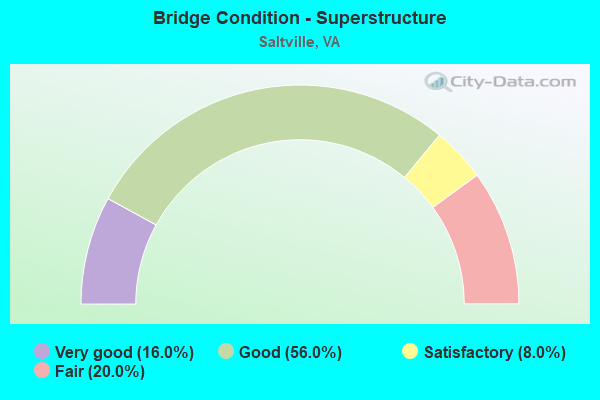
- Bridge Condition - Superstructure
- 16.0%Very good
- 56.0%Good
- 8.0%Satisfactory
- 20.0%Fair
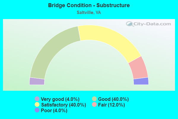
- Bridge Condition - Substructure
- 4.0%Very good
- 40.0%Good
- 40.0%Satisfactory
- 12.0%Fair
- 4.0%Poor
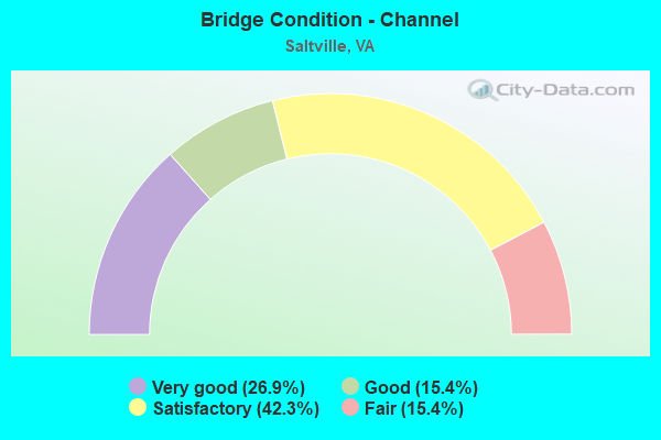
- Bridge Condition - Channel
- 26.9%Very good
- 15.4%Good
- 42.3%Satisfactory
- 15.4%Fair
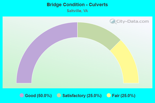
- Bridge Condition - Culverts
- 50.0%Good
- 25.0%Satisfactory
- 25.0%Fair
Find on map >> Show street view
Structure Number: 26, Location: 0.46 Rt 640; 0.30 Rt 638 (Lat: 37.492442, Lng: -79.439467), Route carried "on" structure: State highway 122, Year Built: 1938, Status: Open, Structure Length: 1.98m (6.50ft), Average Daily Traffic: 1,584 (year 2020), Truck Traffic: 6%, Average Future Daily Traffic: 2,218 (year 2040), Design Load: H 15, Features Intersected: Reed Creek
Minimum Vertical Clearance: 30+ m (98+ ft), Kilometerpoint: 78.822, Lanes on structure: 2, Base Highway Network: Yes, Owner: State Highway Agency, Approaching Roadway Width: 6.1m (20.0ft), Skew: 4 degrees, Material/Design: Concrete, Design/Construction: Tee Beam, Number Of Spans In Main Unit: 2, Length of Maximum Span: 10.1m (33.1ft), Curb or Sidewalk Widths: Left: 0.2m (0.7ft), Right: 0.2m (0.7ft), Curb-To-Curb Width: 7.0m (23.0ft), Out-to-Out Width: 7.9m (25.9ft)
Condition: Deck: Fair, Superstructure: Fair, Substructure: Satisfactory, Channel: Very good, Operating Rating: 46.3 metric tons, Method Used To Determine Operating Rating: Load and Resistance Factor (LRFR), Inventory Rating: 35.4 metric tons, Method Used To Determine Inventory Rating: Load and Resistance Factor (LRFR), Structural Evaluation: Somewhat better than minimum adequacy, Deck Geometry: High priority of corrective action, Waterway Adequacy: Better than present minimum criteria, Approach Roadway Alignment: Equal to present desirable criteria, Length Of Structure Improvement: 2.74m (8.99ft), Designated Inspection Frequency: Every 24 months, Inspection Date: January 2022, Bridge Improvement Cost: $844,000, Roadway Improvement Cost: $296,000, Total Project Cost: $2,744,000 ( Estimate for 2020), Deck Structure Type: Concrete Cast-file-Place, Wearing Surface/Protective System: Wearing Surface: Bituminous
Find on map >> Show street view
Structure Number: 17502, Location: 1.13ECL.SALTV;2.24WASH.CL (Lat: 36.890658, Lng: -81.749542), Route carried "on" structure: State highway 91, Year Built: 1957, Status: Open, Structure Length: 5.78m (18.96ft), Average Daily Traffic: 1,882 (year 2020), Truck Traffic: 3%, Average Future Daily Traffic: 2,070 (year 2040), Design Load: HS 15, Features Intersected: NF HOLSTON RIVER, Facility Carried by Structure: EAST MAIN STREET
Minimum Vertical Clearance: 30+ m (98+ ft), Kilometerpoint: 41.263, Lanes on structure: 2, Owner: State Highway Agency, Approaching Roadway Width: 6.4m (21.0ft), Skew: 1 degrees, Material/Design: Steel, Design/Construction: Stringer/Multi-beam, Number Of Spans In Main Unit: 3, Length of Maximum Span: 19.1m (62.7ft), Curb or Sidewalk Widths: Left: 1.5m (4.9ft), Right: 0.5m (1.6ft), Curb-To-Curb Width: 7.3m (24.0ft), Out-to-Out Width: 10.1m (33.1ft)
Condition: Deck: Fair, Superstructure: Fair, Substructure: Satisfactory, Channel: Satisfactory, Operating Rating: 47.2 metric tons, Method Used To Determine Operating Rating: Load and Resistance Factor (LRFR), Inventory Rating: 36.3 metric tons, Method Used To Determine Inventory Rating: Load and Resistance Factor (LRFR), Structural Evaluation: Somewhat better than minimum adequacy, Deck Geometry: Meets minimum limits, Waterway Adequacy: Equal to present minimum criteria, Approach Roadway Alignment: Better than present minimum criteria, Length Of Structure Improvement: 5.79m (19.00ft), Designated Inspection Frequency: Every 24 months, Inspection Date: June 2021, Bridge Improvement Cost: $120,000, Roadway Improvement Cost: $15,000, Total Project Cost: $176,000 ( Estimate for 2018), Deck Structure Type: Concrete Cast-file-Place
Find on map >> Show street view
Structure Number: 17505, Location: 4.57 TO RT42;2.22 TO R107 (Lat: 36.903406, Lng: -81.737844), Route carried "on" structure: State highway 91, Year Built: 1964, Status: Open, Structure Length: 0.94m (3.08ft), Average Daily Traffic: 942 (year 2020), Truck Traffic: 2%, Average Future Daily Traffic: 1,036 (year 2040), Design Load: HS 20, Features Intersected: TURKEY RUN CREEK, Facility Carried by Structure: SALTVILLE HWY.
Minimum Vertical Clearance: 30+ m (98+ ft), Kilometerpoint: 43.531, Lanes on structure: 2, Owner: State Highway Agency, Approaching Roadway Width: 6.4m (21.0ft), Skew: 2 degrees, Material/Design: Concrete, Design/Construction: Culvert, Number Of Spans In Main Unit: 3, Length of Maximum Span: 3.0m (9.8ft)
Condition: Channel: Fair, Culverts: Fair, Operating Rating: 44.5 metric tons, Method Used To Determine Operating Rating: Field evaluation and documented engineering judgment, Inventory Rating: 32.7 metric tons, Method Used To Determine Inventory Rating: Field evaluation and documented engineering judgment, Structural Evaluation: Somewhat better than minimum adequacy, Waterway Adequacy: Equal to present minimum criteria, Approach Roadway Alignment: Better than present minimum criteria, Designated Inspection Frequency: Every 24 months, Inspection Date: August 2021
Find on map >> Show street view
Structure Number: 17554, Location: .15 TO R696 &.7 TO WASHCO (Lat: 36.852742, Lng: -81.750578), Route carried "on" structure: County highway 610, Year Built: 1932, Year Reconstructed: 2017, Status: Open, Structure Length: 0.88m (2.89ft), Average Daily Traffic: 837 (year 2020), Truck Traffic: 2%, Average Future Daily Traffic: 921 (year 2040), Design Load: HL 93, Features Intersected: BRANCH, Facility Carried by Structure: OLD QUARRY RD.
Minimum Vertical Clearance: 30+ m (98+ ft), Kilometerpoint: 0.885, Lanes on structure: 2, Owner: State Highway Agency, Approaching Roadway Width: 5.5m (18.0ft), Skew: 3 degrees, Material/Design: Concrete, Design/Construction: Slab, Number Of Spans In Main Unit: 1, Length of Maximum Span: 7.4m (24.3ft), Curb-To-Curb Width: 6.2m (20.3ft), Out-to-Out Width: 6.6m (21.7ft)
Condition: Deck: Good, Superstructure: Good, Substructure: Satisfactory, Channel: Satisfactory, Operating Rating: 89.8 metric tons, Method Used To Determine Operating Rating: Load and Resistance Factor (LRFR), Inventory Rating: 88.9 metric tons, Method Used To Determine Inventory Rating: Load and Resistance Factor (LRFR), Structural Evaluation: Equal to present minimum criteria, Waterway Adequacy: Better than present minimum criteria, Approach Roadway Alignment: Better than present minimum criteria, Length Of Structure Improvement: 0.85m (2.79ft), Designated Inspection Frequency: Every 24 months, Inspection Date: October 2021, Bridge Improvement Cost: $62,000, Roadway Improvement Cost: $25,000, Total Project Cost: $113,000, Deck Structure Type: Concrete Precast Panels, Wearing Surface/Protective System: Wearing Surface: Bituminous
Find on map >> Show street view
Structure Number: 17599, Location: 3.49 FR 91 - 0.01 TO 623 (Lat: 36.906878, Lng: -81.701256), Route carried "on" structure: County highway 632, Year Built: 1979, Status: Open, Structure Length: 0.98m (3.22ft), Average Daily Traffic: 397 (year 2017), Average Future Daily Traffic: 580 (year 2040), Design Load: HS 20, Features Intersected: BEAVER CREEK, Facility Carried by Structure: CEDAR BRANCH RD.
Minimum Vertical Clearance: 30+ m (98+ ft), Kilometerpoint: 0.000, Lanes on structure: 2, Owner: State Highway Agency, Approaching Roadway Width: 5.5m (18.0ft), Material/Design: Concrete, Design/Construction: Slab, Number Of Spans In Main Unit: 1, Length of Maximum Span: 8.9m (29.2ft), Curb-To-Curb Width: 13.7m (44.9ft), Out-to-Out Width: 14.9m (48.9ft)
Condition: Deck: Satisfactory, Superstructure: Satisfactory, Substructure: Satisfactory, Channel: Satisfactory, Operating Rating: 89.8 metric tons, Method Used To Determine Operating Rating: Load and Resistance Factor (LRFR), Inventory Rating: 88.9 metric tons, Method Used To Determine Inventory Rating: Load and Resistance Factor (LRFR), Structural Evaluation: Equal to present minimum criteria, Deck Geometry: Superior to present desirable criteria, Waterway Adequacy: Better than present minimum criteria, Approach Roadway Alignment: Better than present minimum criteria, Length Of Structure Improvement: 0.98m (3.22ft), Designated Inspection Frequency: Every 24 months, Inspection Date: September 2021, Bridge Improvement Cost: $20,000, Roadway Improvement Cost: $10,000, Total Project Cost: $33,000 ( Estimate for 2015), Deck Structure Type: Concrete Cast-file-Place
Find on map >> Show street view
Structure Number: 17707, Location: 2.6 TO R610;.0 TO R633 (Lat: 36.900808, Lng: -81.693536), Route carried "on" structure: County highway 723, Year Built: 1932, Status: Open, Structure Length: 0.70m (2.30ft), Average Daily Traffic: 326 (year 2020), Truck Traffic: 3%, Average Future Daily Traffic: 359 (year 2040), Design Load: HS 20+Mod, Features Intersected: BEAVER CREEK, Facility Carried by Structure: POSSUM HOLLOW ROAD
Minimum Vertical Clearance: 30+ m (98+ ft), Kilometerpoint: 4.183, Lanes on structure: 2, Owner: State Highway Agency, Approaching Roadway Width: 5.5m (18.0ft), Material/Design: Concrete, Design/Construction: Slab, Number Of Spans In Main Unit: 1, Length of Maximum Span: 6.2m (20.3ft), Curb or Sidewalk Widths: Left: 0.3m (1.0ft), Right: 0.3m (1.0ft), Curb-To-Curb Width: 7.3m (24.0ft), Out-to-Out Width: 7.9m (25.9ft)
Condition: Deck: Fair, Superstructure: Fair, Substructure: Satisfactory, Channel: Very good, Operating Rating: 46.3 metric tons, Method Used To Determine Operating Rating: Load Factor (LF), Inventory Rating: 28.1 metric tons, Method Used To Determine Inventory Rating: Load Factor (LF), Structural Evaluation: Somewhat better than minimum adequacy, Deck Geometry: Somewhat better than minimum adequacy, Waterway Adequacy: Better than present minimum criteria, Approach Roadway Alignment: Better than present minimum criteria, Length Of Structure Improvement: 0.70m (2.30ft), Designated Inspection Frequency: Every 24 months, Inspection Date: November 2021, Bridge Improvement Cost: $48,000, Roadway Improvement Cost: $15,000, Total Project Cost: $819,000, Deck Structure Type: Concrete Cast-file-Place, Wearing Surface/Protective System: Wearing Surface: Epoxy Overlay
Find on map >> Show street view
Structure Number: 18967, Location: 1.47 TO SCL - 7.12 FR 11 (Lat: 36.854367, Lng: -81.781686), Route carried "on" structure: State highway 91, Year Built: 1926, Year Reconstructed: 1976, Status: Posted for load, Structure Length: 1.68m (5.51ft), Average Daily Traffic: 2,089 (year 2020), Truck Traffic: 6%, Average Future Daily Traffic: 2,106 (year 2040), Design Load: H 15, Features Intersected: MCHENRY CREEK, Facility Carried by Structure: CRESCENT ROAD
Minimum Vertical Clearance: 30+ m (98+ ft), Kilometerpoint: 35.301, Lanes on structure: 2, Owner: State Highway Agency, Approaching Roadway Width: 9.1m (29.9ft), Skew: 4 degrees, Material/Design: Concrete, Design/Construction: Tee Beam, Number Of Spans In Main Unit: 2, Length of Maximum Span: 8.5m (27.9ft), Curb or Sidewalk Widths: Left: 0.3m (1.0ft), Right: 0.3m (1.0ft), Curb-To-Curb Width: 9.7m (31.8ft), Out-to-Out Width: 14.9m (48.9ft)
Condition: Deck: Fair, Superstructure: Fair, Substructure: Fair, Channel: Fair, Operating Rating: 23.6 metric tons, Method Used To Determine Operating Rating: Load and Resistance Factor (LRFR), Inventory Rating: 18.1 metric tons, Method Used To Determine Inventory Rating: Load and Resistance Factor (LRFR), Structural Evaluation: Somewhat better than minimum adequacy, Deck Geometry: Meets minimum limits, Waterway Adequacy: Better than present minimum criteria, Approach Roadway Alignment: Better than present minimum criteria, Length Of Structure Improvement: 1.68m (5.51ft), Designated Inspection Frequency: Every 24 months, Inspection Date: March 2021, Bridge Improvement Cost: $165,000, Roadway Improvement Cost: $15,000, Total Project Cost: $234,000 ( Estimate for 2015), Deck Structure Type: Concrete Cast-file-Place, Wearing Surface/Protective System: Wearing Surface: Bituminous
Find on map >> Show street view
Structure Number: 19, Location: 0.00 Fr. 747; 3.00 To 874 (Lat: 36.864142, Lng: -81.839025), Route carried "on" structure: County highway 611, Year Built: 1932, Year Reconstructed: 2016, Status: Open, Structure Length: 2.97m (9.74ft), Average Daily Traffic: 170 (year 2017), Average Future Daily Traffic: 248 (year 2040), Design Load: HL 93, Features Intersected: TUMBLING CREEK, Facility Carried by Structure: N. FORK RIVER ROAD
Minimum Vertical Clearance: 30+ m (98+ ft), Kilometerpoint: 45.071, Lanes on structure: 2, Owner: State Highway Agency, Approaching Roadway Width: 5.5m (18.0ft), Material/Design: Concrete, Design/Construction: Slab, Number Of Spans In Main Unit: 3, Length of Maximum Span: 9.9m (32.5ft), Curb-To-Curb Width: 7.1m (23.3ft), Out-to-Out Width: 7.3m (24.0ft)
Condition: Deck: Good, Superstructure: Good, Substructure: Good, Channel: Very good, Operating Rating: 89.8 metric tons, Method Used To Determine Operating Rating: Load and Resistance Factor (LRFR), Inventory Rating: 88.9 metric tons, Method Used To Determine Inventory Rating: Load and Resistance Factor (LRFR), Structural Evaluation: Better than present minimum criteria, Deck Geometry: Meets minimum limits, Waterway Adequacy: Better than present minimum criteria, Approach Roadway Alignment: Better than present minimum criteria, Designated Inspection Frequency: Every 24 months, Inspection Date: July 2020, Deck Structure Type: Concrete Precast Panels, Wearing Surface/Protective System: Wearing Surface: Epoxy Overlay, Deck Protection: Other
Find on map >> Show street view
Structure Number: 19013, Location: 0.01FR747;2.49TOSMYTHCO (Lat: 36.879250, Lng: -81.839411), Route carried "on" structure: County highway 613, Year Built: 1971, Status: Open, Structure Length: 1.95m (6.40ft), Average Daily Traffic: 510 (year 2020), Truck Traffic: 3%, Average Future Daily Traffic: 561 (year 2040), Design Load: HS 20+Mod, Features Intersected: TUMBLING CREEK, Facility Carried by Structure: Poor Valley Rd.
Minimum Vertical Clearance: 30+ m (98+ ft), Kilometerpoint: 7.208, Lanes on structure: 2, Owner: State Highway Agency, Approaching Roadway Width: 11.6m (38.1ft), Material/Design: Concrete, Design/Construction: Slab, Number Of Spans In Main Unit: 2, Length of Maximum Span: 9.8m (32.2ft), Curb-To-Curb Width: 9.1m (29.9ft), Out-to-Out Width: 9.8m (32.2ft)
Condition: Deck: Fair, Superstructure: Fair, Substructure: Fair, Channel: Satisfactory, Operating Rating: 89.8 metric tons, Method Used To Determine Operating Rating: Load and Resistance Factor (LRFR), Inventory Rating: 78.9 metric tons, Method Used To Determine Inventory Rating: Load and Resistance Factor (LRFR), Structural Evaluation: Somewhat better than minimum adequacy, Deck Geometry: Equal to present minimum criteria, Waterway Adequacy: Better than present minimum criteria, Approach Roadway Alignment: Better than present minimum criteria, Designated Inspection Frequency: Every 24 months, Inspection Date: December 2020, Deck Structure Type: Concrete Cast-file-Place
Find on map >> Show street view
Structure Number: 19178, Location: 0.60 FR. 611; 0.20 TO 613 (Lat: 36.871669, Lng: -81.846044), Route carried "on" structure: County highway 747, Year Built: 1932, Status: Open, Structure Length: 1.86m (6.10ft), Average Daily Traffic: 148 (year 2017), Average Future Daily Traffic: 165 (year 2040), Design Load: H 15, Features Intersected: TUMBLING CREEK, Facility Carried by Structure: TUMBLING CREEK RD
Minimum Vertical Clearance: 30+ m (98+ ft), Kilometerpoint: 0.965, Lanes on structure: 1, Owner: State Highway Agency, Approaching Roadway Width: 4.3m (14.1ft), Skew: 3 degrees, Material/Design: Steel, Design/Construction: Stringer/Multi-beam, Number Of Spans In Main Unit: 2, Length of Maximum Span: 9.4m (30.8ft), Curb or Sidewalk Widths: Left: 0.2m (0.7ft), Right: 0.2m (0.7ft), Curb-To-Curb Width: 3.9m (12.8ft), Out-to-Out Width: 4.5m (14.8ft)
Condition: Deck: Satisfactory, Superstructure: Good, Substructure: Fair, Channel: Fair, Operating Rating: 48.1 metric tons, Method Used To Determine Operating Rating: Load Factor (LF), Inventory Rating: 29.0 metric tons, Method Used To Determine Inventory Rating: Load Factor (LF), Structural Evaluation: Somewhat better than minimum adequacy, Deck Geometry: High priority of replacement, Waterway Adequacy: Better than present minimum criteria, Approach Roadway Alignment: Better than present minimum criteria, Length Of Structure Improvement: 1.86m (6.10ft), Designated Inspection Frequency: Every 24 months, Inspection Date: October 2020, Bridge Improvement Cost: $90,000, Roadway Improvement Cost: $25,000, Total Project Cost: $150,000 ( Estimate for 2016), Deck Structure Type: Wood or Timber, Wearing Surface/Protective System: Wearing Surface: Bituminous
Find on map >> Show street view
Structure Number: 1918, Location: .15 FR END MAI1.85 TO 613 (Lat: 36.903125, Lng: -81.841181), Route carried "on" structure: County highway 747, Year Built: 1932, Year Reconstructed: 2015, Status: Open, Structure Length: 1.16m (3.81ft), Average Daily Traffic: 90 (year 2017), Average Future Daily Traffic: 100 (year 2040), Design Load: HL 93, Features Intersected: TUMBLING CREEK, Facility Carried by Structure: TUMBLING CREEK RD
Minimum Vertical Clearance: 30+ m (98+ ft), Kilometerpoint: 5.181, Lanes on structure: 1, Owner: State Highway Agency, Approaching Roadway Width: 5.5m (18.0ft), Material/Design: Concrete, Design/Construction: Slab, Number Of Spans In Main Unit: 1, Length of Maximum Span: 10.0m (32.8ft), Curb or Sidewalk Widths: Left: 0.2m (0.7ft), Right: 0.2m (0.7ft), Curb-To-Curb Width: 4.9m (16.1ft), Out-to-Out Width: 4.9m (16.1ft)
Condition: Deck: Good, Superstructure: Good, Substructure: Satisfactory, Channel: Good, Operating Rating: 57.2 metric tons, Method Used To Determine Operating Rating: Load and Resistance Factor (LRFR), Inventory Rating: 44.5 metric tons, Method Used To Determine Inventory Rating: Load and Resistance Factor (LRFR), Structural Evaluation: Equal to present minimum criteria, Deck Geometry: High priority of corrective action, Waterway Adequacy: Better than present minimum criteria, Approach Roadway Alignment: Somewhat better than minimum adequacy, Length Of Structure Improvement: 1.13m (3.71ft), Designated Inspection Frequency: Every 24 months, Inspection Date: August 2021, Bridge Improvement Cost: $78,000, Roadway Improvement Cost: $12,000, Total Project Cost: $117,000 ( Estimate for 2014), Deck Structure Type: Concrete Precast Panels, Wearing Surface/Protective System: Wearing Surface: Bituminous
Find on map >> Show street view
Structure Number: 2261, Location: 0.55 91 & 0.45 NCL SALT (Lat: 36.887439, Lng: -81.767472), Route carried "on" structure: City street 634, Year Built: 1993, Status: Open, Structure Length: 5.70m (18.70ft), Average Daily Traffic: 2,576 (year 2020), Truck Traffic: 2%, Average Future Daily Traffic: 2,834 (year 2040), Design Load: HS 20+Mod, Features Intersected: NF HOLSTON RIVER, Facility Carried by Structure: ALLISON GAP RD
Minimum Vertical Clearance: 30+ m (98+ ft), Kilometerpoint: 0.000, Lanes on structure: 2, Owner: Town or Township Highway Agency, Approaching Roadway Width: 7.3m (24.0ft), Skew: 2 degrees, Material/Design: Steel, Design/Construction: Stringer/Multi-beam, Number Of Spans In Main Unit: 2, Length of Maximum Span: 28.3m (92.8ft), Curb-To-Curb Width: 9.5m (31.2ft), Out-to-Out Width: 10.2m (33.5ft)
Condition: Deck: Good, Superstructure: Good, Substructure: Satisfactory, Channel: Good, Operating Rating: 66.2 metric tons, Method Used To Determine Operating Rating: Load and Resistance Factor (LRFR), Inventory Rating: 50.8 metric tons, Method Used To Determine Inventory Rating: Load and Resistance Factor (LRFR), Structural Evaluation: Equal to present minimum criteria, Waterway Adequacy: Better than present minimum criteria, Approach Roadway Alignment: Equal to present desirable criteria, Designated Inspection Frequency: Every 24 months, Inspection Date: December 2020, Deck Structure Type: Concrete Cast-file-Place
Find on map >> Show street view
Structure Number: 22611, Location: .30 TO R91 & AT ENDMAINT (Lat: 36.891531, Lng: -81.758272), Route carried "on" structure: City street , Year Built: 1978, Status: Open, Structure Length: 4.91m (16.11ft), Average Daily Traffic: 75 (year 1991), Average Future Daily Traffic: 113 (year 2035), Design Load: HS 20+Mod, Features Intersected: N F HOLSTON RIVER, Facility Carried by Structure: GOV. PLANT ROAD
Minimum Vertical Clearance: 30+ m (98+ ft), Kilometerpoint: 0.000, Lanes on structure: 2, Owner: Town or Township Highway Agency, Approaching Roadway Width: 8.5m (27.9ft), Material/Design: Prestressed concrete, Design/Construction: Box Beam or Girders - Multiple, Number Of Spans In Main Unit: 3, Length of Maximum Span: 16.5m (54.1ft), Curb-To-Curb Width: 7.2m (23.6ft), Out-to-Out Width: 8.2m (26.9ft)
Condition: Deck: Satisfactory, Superstructure: Satisfactory, Substructure: Poor, Channel: Satisfactory, Operating Rating: 72.6 metric tons, Method Used To Determine Operating Rating: Load and Resistance Factor (LRFR), Inventory Rating: 54.4 metric tons, Method Used To Determine Inventory Rating: Load and Resistance Factor (LRFR), Structural Evaluation: Meets minimum limits, Deck Geometry: Somewhat better than minimum adequacy, Waterway Adequacy: Better than present minimum criteria, Approach Roadway Alignment: Better than present minimum criteria, Length Of Structure Improvement: 4.91m (16.11ft), Designated Inspection Frequency: Every 24 months, Other Special Inspection Frequency: Every 12 months, Inspection Date: December 2020, Other Special Inspection Date: December 2020, Bridge Improvement Cost: $200,000, Roadway Improvement Cost: $25,000, Total Project Cost: $293,000, Deck Structure Type: Concrete Cast-file-Place, Wearing Surface/Protective System: Wearing Surface: Bituminous
Find on map >> Show street view
Structure Number: 25627, Location: 1.68 TO 687 / 1.68 TO 672 (Lat: 36.615869, Lng: -76.998206), Route carried "on" structure: County highway 684, Year Built: 1999, Status: Open, Structure Length: 25.54m (83.79ft), Average Daily Traffic: 649 (year 2020), Truck Traffic: 4%, Average Future Daily Traffic: 784 (year 2040), Design Load: HS 20+Mod, Features Intersected: Nottoway River, Facility Carried by Structure: Monroe Road
Minimum Vertical Clearance: 30+ m (98+ ft), Kilometerpoint: 10.487, Lanes on structure: 2, Owner: State Highway Agency, Approaching Roadway Width: 8.5m (27.9ft), Material/Design: Concrete continuous, Design/Construction: Stringer/Multi-beam, Number Of Spans In Main Unit: 12, Length of Maximum Span: 21.3m (69.9ft), Curb-To-Curb Width: 8.6m (28.2ft), Out-to-Out Width: 9.6m (31.5ft)
Condition: Deck: Satisfactory, Superstructure: Good, Substructure: Good, Channel: Very good, Operating Rating: 99.8 metric tons, Method Used To Determine Operating Rating: Load and Resistance Factor (LRFR), Inventory Rating: 78.9 metric tons, Method Used To Determine Inventory Rating: Load and Resistance Factor (LRFR), Structural Evaluation: Better than present minimum criteria, Deck Geometry: Somewhat better than minimum adequacy, Waterway Adequacy: Equal to present desirable criteria, Approach Roadway Alignment: Equal to present desirable criteria, Designated Inspection Frequency: Every 24 months, Underwater Inspection Frequency: Every 60 months, Inspection Date: November 2021, Underwater Inspection Date: October 2019, Deck Structure Type: Concrete Cast-file-Place, Wearing Surface/Protective System: Wearing Surface: Monolithic Concrete, Deck Protection: Epoxy Coated Reinforcing
Find on map >> Show street view
Structure Number: 25685, Location: 0.20fr621 0.03to1273 (Lat: 38.913222, Lng: -77.510694), Route carried "on" structure: Alternate County highway 1263, Year Built: 1997, Status: Open, Structure Length: 1.04m (3.41ft), Average Daily Traffic: 1,200 (year 2014), Average Future Daily Traffic: 1,189 (year 2040), Design Load: HS 20, Features Intersected: TRIB. OF ELKLICK RUN, Facility Carried by Structure: CENTER STREET
Minimum Vertical Clearance: 30.18m (99.02ft), Kilometerpoint: 0.000, Lanes on structure: 2, Owner: State Highway Agency, Approaching Roadway Width: 8.2m (26.9ft), Material/Design: Concrete, Design/Construction: Arch - Deck, Number Of Spans In Main Unit: 1, Length of Maximum Span: 9.8m (32.2ft), Curb or Sidewalk Widths: Left: 1.2m (3.9ft), Right: 1.2m (3.9ft), Curb-To-Curb Width: 7.3m (24.0ft), Out-to-Out Width: 27.4m (89.9ft)
Condition: Deck: Very good, Superstructure: Very good, Substructure: Very good, Channel: Satisfactory, Operating Rating: 44.5 metric tons, Method Used To Determine Operating Rating: Field evaluation and documented engineering judgment, Inventory Rating: 32.7 metric tons, Method Used To Determine Inventory Rating: Field evaluation and documented engineering judgment, Structural Evaluation: Equal to present desirable criteria, Deck Geometry: Meets minimum limits, Waterway Adequacy: Better than present minimum criteria, Approach Roadway Alignment: Better than present minimum criteria, Designated Inspection Frequency: Every 24 months, Inspection Date: July 2020, Deck Structure Type: Concrete Precast Panels, Wearing Surface/Protective System: Wearing Surface: Other
Find on map >> Show street view
Structure Number: 25687, Location: .45M TO 640 & 2.2M TO 651 (Lat: 36.964461, Lng: -82.010531), Route carried "on" structure: County highway 652, Year Built: 2009, Status: Open, Structure Length: 9.20m (30.18ft), Average Daily Traffic: 83 (year 2015), Average Future Daily Traffic: 93 (year 2040), Design Load: HS 20+Mod, Features Intersected: CLINCH RIVER
Minimum Vertical Clearance: 30+ m (98+ ft), Kilometerpoint: 0.000, Lanes on structure: 2, Owner: State Highway Agency, Approaching Roadway Width: 6.7m (22.0ft), Material/Design: Steel continuous, Design/Construction: Stringer/Multi-beam, Number Of Spans In Main Unit: 3, Length of Maximum Span: 36.6m (120.1ft), Curb-To-Curb Width: 7.9m (25.9ft), Out-to-Out Width: 8.6m (28.2ft)
Condition: Deck: Good, Superstructure: Very good, Substructure: Good, Channel: Very good, Operating Rating: 63.5 metric tons, Method Used To Determine Operating Rating: Load and Resistance Factor (LRFR), Inventory Rating: 49.0 metric tons, Method Used To Determine Inventory Rating: Load and Resistance Factor (LRFR), Structural Evaluation: Better than present minimum criteria, Deck Geometry: Equal to present minimum criteria, Waterway Adequacy: Better than present minimum criteria, Approach Roadway Alignment: Better than present minimum criteria, Designated Inspection Frequency: Every 24 months, Inspection Date: June 2021, Deck Structure Type: Concrete Cast-file-Place, Wearing Surface/Protective System: Deck Protection: Epoxy Coated Reinforcing
Find on map >> Show street view
Structure Number: 25691, Location: 1.15-Rte835/.10Rte765 (Lat: 36.642911, Lng: -80.247703), Route carried "on" structure: US 58, Year Built: 2000, Status: Open, Structure Length: 1.89m (6.20ft), Average Daily Traffic: 4,310 (year 2020), Truck Traffic: 9%, Average Future Daily Traffic: 6,035 (year 2040), Design Load: HS 20+Mod, Features Intersected: Rhody Creek
Minimum Vertical Clearance: 30+ m (98+ ft), Kilometerpoint: 387.335, Lanes on structure: 2, Base Highway Network: Yes, Owner: State Highway Agency, Approaching Roadway Width: 7.9m (25.9ft), Skew: 4 degrees, Material/Design: Prestressed concrete, Design/Construction: Stringer/Multi-beam, Number Of Spans In Main Unit: 1, Length of Maximum Span: 18.0m (59.1ft), Curb-To-Curb Width: 11.9m (39.0ft), Out-to-Out Width: 13.0m (42.7ft)
Condition: Deck: Good, Superstructure: Good, Substructure: Good, Channel: Very good, Operating Rating: 89.8 metric tons, Method Used To Determine Operating Rating: Load and Resistance Factor (LRFR), Inventory Rating: 71.7 metric tons, Method Used To Determine Inventory Rating: Load and Resistance Factor (LRFR), Structural Evaluation: Better than present minimum criteria, Deck Geometry: Better than present minimum criteria, Waterway Adequacy: Equal to present minimum criteria, Approach Roadway Alignment: Equal to present desirable criteria, Designated Inspection Frequency: Every 24 months, Inspection Date: August 2020, Deck Structure Type: Concrete Cast-file-Place, Wearing Surface/Protective System: Deck Protection: Epoxy Coated Reinforcing
Find on map >> Show street view
Structure Number: 25764, Location: .5 MI FR WA CO -.35 TO696 (Lat: 36.854456, Lng: -81.753206), Route carried "on" structure: County highway 610, Year Built: 1998, Status: Open, Structure Length: 0.98m (3.22ft), Average Daily Traffic: 837 (year 2020), Truck Traffic: 2%, Average Future Daily Traffic: 921 (year 2040), Design Load: HS 20, Features Intersected: BRANCH, Facility Carried by Structure: OLD QUARRY RD.
Minimum Vertical Clearance: 30+ m (98+ ft), Kilometerpoint: 1.207, Lanes on structure: 2, Owner: State Highway Agency, Approaching Roadway Width: 5.5m (18.0ft), Skew: 3 degrees, Material/Design: Concrete, Design/Construction: Slab, Number Of Spans In Main Unit: 1, Length of Maximum Span: 8.9m (29.2ft), Curb-To-Curb Width: 7.9m (25.9ft), Out-to-Out Width: 8.5m (27.9ft)
Condition: Deck: Good, Superstructure: Good, Substructure: Good, Channel: Good, Operating Rating: 89.8 metric tons, Method Used To Determine Operating Rating: Load and Resistance Factor (LRFR), Inventory Rating: 88.9 metric tons, Method Used To Determine Inventory Rating: Load and Resistance Factor (LRFR), Structural Evaluation: Better than present minimum criteria, Deck Geometry: Somewhat better than minimum adequacy, Waterway Adequacy: Better than present minimum criteria, Approach Roadway Alignment: Better than present minimum criteria, Designated Inspection Frequency: Every 24 months, Inspection Date: August 2020, Deck Structure Type: Concrete Cast-file-Place, Wearing Surface/Protective System: Deck Protection: Epoxy Coated Reinforcing
Find on map >> Show street view
Structure Number: 25774, Location: 0.78 RT 654 - 1.05 RT 648 (Lat: 38.406033, Lng: -79.437256), Route carried "on" structure: County highway 619, Year Built: 1998, Status: Open, Structure Length: 0.88m (2.89ft), Average Daily Traffic: 50 (year 2018), Average Future Daily Traffic: 57 (year 2040), Design Load: HS 20, Features Intersected: TRIB. BULLPASTURE RIVER, Facility Carried by Structure: BOTKIN HOLLOW ROAD
Minimum Vertical Clearance: 30+ m (98+ ft), Kilometerpoint: 1.368, Lanes on structure: 2, Owner: State Highway Agency, Approaching Roadway Width: 11.0m (36.1ft), Skew: 3 degrees, Material/Design: Steel, Design/Construction: Culvert, Number Of Spans In Main Unit: 3, Length of Maximum Span: 2.1m (6.9ft)
Condition: Channel: Satisfactory, Culverts: Satisfactory, Operating Rating: 32.7 metric tons, Method Used To Determine Operating Rating: Field evaluation and documented engineering judgment, Inventory Rating: 31.8 metric tons, Method Used To Determine Inventory Rating: Field evaluation and documented engineering judgment, Structural Evaluation: Equal to present minimum criteria, Waterway Adequacy: Equal to present minimum criteria, Approach Roadway Alignment: Equal to present desirable criteria, Designated Inspection Frequency: Every 24 months, Inspection Date: March 2021
Find on map >> Show street view
Structure Number: 25848, Location: .3 MI FR 91-.3 MI TO 613 (Lat: 36.906822, Lng: -81.736869), Route carried "on" structure: County highway 633, Year Built: 1998, Status: Open, Structure Length: 0.98m (3.22ft), Average Daily Traffic: 306 (year 2018), Average Future Daily Traffic: 340 (year 2040), Design Load: HS 20, Features Intersected: TURKEY RUN CREEK, Facility Carried by Structure: UPPER POOR VAL RD
Minimum Vertical Clearance: 30+ m (98+ ft), Kilometerpoint: 11.376, Lanes on structure: 2, Owner: State Highway Agency, Approaching Roadway Width: 5.8m (19.0ft), Skew: 4 degrees, Material/Design: Concrete, Design/Construction: Slab, Number Of Spans In Main Unit: 1, Length of Maximum Span: 8.9m (29.2ft), Curb-To-Curb Width: 7.9m (25.9ft), Out-to-Out Width: 8.6m (28.2ft)
Condition: Deck: Good, Superstructure: Good, Substructure: Satisfactory, Channel: Satisfactory, Operating Rating: 89.8 metric tons, Method Used To Determine Operating Rating: Load and Resistance Factor (LRFR), Inventory Rating: 88.9 metric tons, Method Used To Determine Inventory Rating: Load and Resistance Factor (LRFR), Structural Evaluation: Equal to present minimum criteria, Deck Geometry: Somewhat better than minimum adequacy, Waterway Adequacy: Better than present minimum criteria, Approach Roadway Alignment: High priority of corrective action, Length Of Structure Improvement: 0.98m (3.22ft), Designated Inspection Frequency: Every 24 months, Inspection Date: Febuary 2021, Bridge Improvement Cost: $56,000, Roadway Improvement Cost: $15,000, Total Project Cost: $115,000 ( Estimate for 2015), Deck Structure Type: Concrete Cast-file-Place, Wearing Surface/Protective System: Deck Protection: Epoxy Coated Reinforcing
Find on map >> Show street view
Structure Number: 25884, Location: 1.05 FR 722 0.05 DEAD END (Lat: 36.615103, Lng: -78.556503), Route carried "on" structure: County highway 784, Year Built: 2005, Status: Open, Structure Length: 7.07m (23.20ft), Average Daily Traffic: 104 (year 2019), Average Future Daily Traffic: 115 (year 2040), Design Load: HS 20+Mod, Features Intersected: U.S. 58, Facility Carried by Structure: IRON GATE ROAD
Minimum Vertical Clearance: 30+ m (98+ ft), Kilometerpoint: 1.689, Lanes on structure: 2, Lanes under structure: 4, Owner: State Highway Agency, Approaching Roadway Width: 8.5m (27.9ft), Material/Design: Steel continuous, Design/Construction: Stringer/Multi-beam, Number Of Spans In Main Unit: 2, Length of Maximum Span: 37.2m (122.0ft), Curb or Sidewalk Widths: Left: 0.5m (1.6ft), Right: 0.5m (1.6ft), Curb-To-Curb Width: 8.6m (28.2ft), Out-to-Out Width: 9.6m (31.5ft)
Condition: Deck: Good, Superstructure: Good, Substructure: Good, Operating Rating: 67.1 metric tons, Method Used To Determine Operating Rating: Load and Resistance Factor (LRFR), Inventory Rating: 51.7 metric tons, Method Used To Determine Inventory Rating: Load and Resistance Factor (LRFR), Structural Evaluation: Better than present minimum criteria, Deck Geometry: Equal to present minimum criteria, Underclear: Better than present minimum criteria, Approach Roadway Alignment: Equal to present desirable criteria, Length Of Structure Improvement: 7.07m (23.20ft), Designated Inspection Frequency: Every 24 months, Inspection Date: August 2021, Bridge Improvement Cost: $100,000, Roadway Improvement Cost: $100,000, Total Project Cost: $211,000, Deck Structure Type: Concrete Cast-file-Place, Wearing Surface/Protective System: Deck Protection: Epoxy Coated Reinforcing
Find on map >> Show street view
Structure Number: 25887, Location: 2.50 FR 15 & 0.60 TO 364 (Lat: 36.633606, Lng: -78.539708), Route carried "on" structure: Ramp US 58, Year Built: 2005, Status: Open, Structure Length: 10.61m (34.81ft), Average Daily Traffic: 2,747 (year 2020), Truck Traffic: 9%, Average Future Daily Traffic: 3,543 (year 2040), Design Load: HS 20+Mod, Features Intersected: CONN BETW 58BP & 15(58B)
Minimum Vertical Clearance: 30+ m (98+ ft), Kilometerpoint: 564.276, Lanes on structure: 1, Lanes under structure: 5, Base Highway Network: Yes, Owner: State Highway Agency, Approaching Roadway Width: 9.1m (29.9ft), Skew: 4 degrees, Material/Design: Steel continuous, Design/Construction: Stringer/Multi-beam, Number Of Spans In Main Unit: 4, Length of Maximum Span: 32.9m (107.9ft), Curb-To-Curb Width: 9.0m (29.5ft), Out-to-Out Width: 9.9m (32.5ft)
Condition: Deck: Good, Superstructure: Very good, Substructure: Good, Operating Rating: 47.2 metric tons, Method Used To Determine Operating Rating: Load and Resistance Factor (LRFR), Inventory Rating: 36.3 metric tons, Method Used To Determine Inventory Rating: Load and Resistance Factor (LRFR), Structural Evaluation: Better than present minimum criteria, Deck Geometry: Superior to present desirable criteria, Underclear: Better than present minimum criteria, Approach Roadway Alignment: Equal to present desirable criteria, Length Of Structure Improvement: 10.61m (34.81ft), Designated Inspection Frequency: Every 24 months, Inspection Date: September 2021, Bridge Improvement Cost: $200,000, Roadway Improvement Cost: $100,000, Total Project Cost: $301,000, Deck Structure Type: Concrete Cast-file-Place, Wearing Surface/Protective System: Deck Protection: Epoxy Coated Reinforcing
Find on map >> Show street view
Structure Number: 2598, Location: .02 From 628 & .92 To 632 (Lat: 38.261244, Lng: -78.593531), Route carried "on" structure: County highway 614, Year Built: 1999, Status: Open, Structure Length: 1.37m (4.49ft), Average Daily Traffic: 14 (year 2020), Average Future Daily Traffic: 20 (year 2040), Design Load: HS 20, Features Intersected: Lynch River, Facility Carried by Structure: Brokenback Mtn Rd
Minimum Vertical Clearance: 30+ m (98+ ft), Kilometerpoint: 0.032, Lanes on structure: 2, Owner: State Highway Agency, Approaching Roadway Width: 7.0m (23.0ft), Material/Design: Prestressed concrete, Design/Construction: Slab, Number Of Spans In Main Unit: 1, Length of Maximum Span: 13.7m (44.9ft), Curb-To-Curb Width: 6.6m (21.7ft), Out-to-Out Width: 7.3m (24.0ft)
Condition: Deck: Good, Superstructure: Good, Substructure: Satisfactory, Channel: Good, Operating Rating: 79.8 metric tons, Method Used To Determine Operating Rating: Load and Resistance Factor (LRFR), Inventory Rating: 61.7 metric tons, Method Used To Determine Inventory Rating: Load and Resistance Factor (LRFR), Structural Evaluation: Equal to present minimum criteria, Deck Geometry: Somewhat better than minimum adequacy, Waterway Adequacy: Equal to present minimum criteria, Approach Roadway Alignment: Equal to present desirable criteria, Designated Inspection Frequency: Every 24 months, Inspection Date: March 2021, Deck Structure Type: Other, Wearing Surface/Protective System: Wearing Surface: Bituminous, Membrane: Epoxy
Find on map >> Show street view
Structure Number: 25992, Location: 2.40 RT 11; 0.90 RT 114 (Lat: 37.153728, Lng: -80.411333), Route carried "on" structure: US 460, Year Built: 2002, Status: Open, Structure Length: 8.06m (26.44ft), Average Daily Traffic: 15,169 (year 2020), Truck Traffic: 5%, Average Future Daily Traffic: 15,734 (year 2040), Design Load: HS 20+Mod, Features Intersected: RAMP C_460 BUSINESS WBL
Minimum Vertical Clearance: 30+ m (98+ ft), Kilometerpoint: 195.670, Lanes on structure: 2, Lanes under structure: 1, Base Highway Network: Yes, Owner: State Highway Agency, Approaching Roadway Width: 12.2m (40.0ft), Material/Design: Steel, Design/Construction: Stringer/Multi-beam, Number Of Spans In Main Unit: 2, Length of Maximum Span: 39.9m (130.9ft), Curb-To-Curb Width: 12.0m (39.4ft), Out-to-Out Width: 13.0m (42.7ft)
Condition: Deck: Good, Superstructure: Good, Substructure: Good, Operating Rating: 73.5 metric tons, Method Used To Determine Operating Rating: Load and Resistance Factor (LRFR), Inventory Rating: 56.2 metric tons, Method Used To Determine Inventory Rating: Load and Resistance Factor (LRFR), Structural Evaluation: Better than present minimum criteria, Deck Geometry: Equal to present minimum criteria, Underclear: Somewhat better than minimum adequacy, Approach Roadway Alignment: Equal to present desirable criteria, Designated Inspection Frequency: Every 12 months, Critical Feature Inspection Frequency: Every 12 months, Inspection Date: August 2021, Critical Feature Inspection Date: August 2021, Deck Structure Type: Concrete Cast-file-Place, Wearing Surface/Protective System: Deck Protection: Epoxy Coated Reinforcing
Find on map >> Show street view
Structure Number: 26524, Location: 0.02 TO R634&.050SVILLE C (Lat: 36.889656, Lng: -81.772203), Route carried "on" structure: City street 611, Year Built: 2000, Status: Open, Structure Length: 1.34m (4.40ft), Average Daily Traffic: 180 (year 2014), Average Future Daily Traffic: 225 (year 2035), Design Load: HS 20+Mod, Features Intersected: ALLISON GAP CREEK, Facility Carried by Structure: PERRYVILL ROAD
Minimum Vertical Clearance: 30+ m (98+ ft), Kilometerpoint: 0.000, Lanes on structure: 1, Owner: Town or Township Highway Agency, Approaching Roadway Width: 8.5m (27.9ft), Skew: 1 degrees, Material/Design: Concrete, Design/Construction: Culvert, Number Of Spans In Main Unit: 4, Length of Maximum Span: 3.0m (9.8ft)
Condition: Channel: Satisfactory, Culverts: Good, Operating Rating: 89.8 metric tons, Method Used To Determine Operating Rating: Load Factor (LF), Inventory Rating: 88.9 metric tons, Method Used To Determine Inventory Rating: Load Factor (LF), Structural Evaluation: Better than present minimum criteria, Waterway Adequacy: Better than present minimum criteria, Approach Roadway Alignment: Equal to present minimum criteria, Designated Inspection Frequency: Every 24 months, Inspection Date: December 2019
Find on map >> Show street view
Structure Number: 26525, Location: 0.10 RTE 611;0.40 RTE 613 (Lat: 36.890544, Lng: -81.772758), Route carried "on" structure: City street 634, Year Built: 2000, Status: Open, Structure Length: 0.91m (2.99ft), Average Daily Traffic: 1,288 (year 2020), Truck Traffic: 2%, Average Future Daily Traffic: 1,417 (year 2040), Design Load: HS 20+Mod, Features Intersected: ALLISON GAP CREEK, Facility Carried by Structure: ALLISON GAP ROAD
Minimum Vertical Clearance: 30+ m (98+ ft), Kilometerpoint: 0.000, Lanes on structure: 1, Owner: Town or Township Highway Agency, Approaching Roadway Width: 9.1m (29.9ft), Skew: 4 degrees, Material/Design: Concrete, Design/Construction: Culvert, Number Of Spans In Main Unit: 2, Length of Maximum Span: 3.0m (9.8ft)
Condition: Channel: Satisfactory, Culverts: Good, Operating Rating: 89.8 metric tons, Method Used To Determine Operating Rating: Load Factor (LF), Inventory Rating: 88.9 metric tons, Method Used To Determine Inventory Rating: Load Factor (LF), Structural Evaluation: Better than present minimum criteria, Waterway Adequacy: Better than present minimum criteria, Approach Roadway Alignment: Equal to present minimum criteria, Designated Inspection Frequency: Every 24 months, Inspection Date: December 2019
Find on map >> Show street view
Structure Number: 27794, Location: 1.4 TO R633;1.2 TO R610 (Lat: 36.883117, Lng: -81.696053), Route carried "on" structure: County highway 723, Year Built: 2003, Status: Open, Structure Length: 0.70m (2.30ft), Average Daily Traffic: 326 (year 2020), Truck Traffic: 3%, Average Future Daily Traffic: 359 (year 2040), Design Load: HS 20+Mod, Features Intersected: BRANCH, Facility Carried by Structure: POSSUM HOLLOW ROAD
Minimum Vertical Clearance: 30+ m (98+ ft), Kilometerpoint: 1.931, Lanes on structure: 1, Owner: State Highway Agency, Approaching Roadway Width: 5.5m (18.0ft), Skew: 4 degrees, Material/Design: Concrete, Design/Construction: Frame, Number Of Spans In Main Unit: 1, Length of Maximum Span: 6.5m (21.3ft), Curb-To-Curb Width: 6.7m (22.0ft), Out-to-Out Width: 7.6m (24.9ft)
Condition: Deck: Good, Superstructure: Good, Substructure: Good, Channel: Fair, Operating Rating: 58.1 metric tons, Method Used To Determine Operating Rating: Load and Resistance Factor (LRFR), Inventory Rating: 45.4 metric tons, Method Used To Determine Inventory Rating: Load and Resistance Factor (LRFR), Structural Evaluation: Better than present minimum criteria, Deck Geometry: Meets minimum limits, Waterway Adequacy: Better than present minimum criteria, Approach Roadway Alignment: Better than present minimum criteria, Length Of Structure Improvement: 0.70m (2.30ft), Designated Inspection Frequency: Every 24 months, Inspection Date: Febuary 2022, Bridge Improvement Cost: $58,000, Roadway Improvement Cost: $25,000, Total Project Cost: $108,000, Deck Structure Type: Concrete Precast Panels, Wearing Surface/Protective System: Wearing Surface: Bituminous, Deck Protection: Epoxy Coated Reinforcing
Find on map >> Show street view
Structure Number: 28101, Location: 0.10 TO R 91-.90 TO R 750 (Lat: 36.860594, Lng: -81.788808), Route carried "on" structure: County highway 745, Year Built: 2005, Status: Open, Structure Length: 2.90m (9.51ft), Average Daily Traffic: 528 (year 2020), Truck Traffic: 1%, Average Future Daily Traffic: 581 (year 2040), Features Intersected: MCHENRY CREEK
Minimum Vertical Clearance: 30+ m (98+ ft), Kilometerpoint: 11.907, Lanes on structure: 2, Owner: State Highway Agency, Approaching Roadway Width: 8.5m (27.9ft), Material/Design: Steel, Design/Construction: Arch - Deck, Number Of Spans In Main Unit: 1, Length of Maximum Span: 11.6m (38.1ft), Curb-To-Curb Width: 13.4m (44.0ft), Out-to-Out Width: 29.0m (95.1ft)
Condition: Superstructure: Good, Substructure: Satisfactory, Channel: Satisfactory, Operating Rating: 44.5 metric tons, Method Used To Determine Operating Rating: Field evaluation and documented engineering judgment, Inventory Rating: 32.7 metric tons, Method Used To Determine Inventory Rating: Field evaluation and documented engineering judgment, Structural Evaluation: Equal to present minimum criteria, Deck Geometry: Superior to present desirable criteria, Waterway Adequacy: Superior to present desirable criteria, Approach Roadway Alignment: Better than present minimum criteria, Designated Inspection Frequency: Every 24 months, Inspection Date: May 2021
Find on map >> Show street view
Structure Number: 2931, Location: 1.30 FR. 613-0.70 TO END (Lat: 36.895492, Lng: -81.842989), Route carried "on" structure: County highway 747, Year Built: 2012, Status: Open, Structure Length: 2.44m (8.01ft), Average Daily Traffic: 90 (year 2017), Average Future Daily Traffic: 100 (year 2040), Design Load: HL 93, Features Intersected: Tumbling Creek, Facility Carried by Structure: Tumbling Creek RD
Minimum Vertical Clearance: 30+ m (98+ ft), Kilometerpoint: 4.295, Lanes on structure: 1, Owner: State Highway Agency, Approaching Roadway Width: 4.9m (16.1ft), Skew: 4 degrees, Material/Design: Steel, Design/Construction: Stringer/Multi-beam, Number Of Spans In Main Unit: 1, Length of Maximum Span: 23.3m (76.4ft), Curb-To-Curb Width: 6.7m (22.0ft), Out-to-Out Width: 7.4m (24.3ft)
Condition: Deck: Good, Superstructure: Very good, Substructure: Good, Channel: Very good, Operating Rating: 89.8 metric tons, Method Used To Determine Operating Rating: Load and Resistance Factor (LRFR), Inventory Rating: 88.9 metric tons, Method Used To Determine Inventory Rating: Load and Resistance Factor (LRFR), Structural Evaluation: Better than present minimum criteria, Deck Geometry: Somewhat better than minimum adequacy, Waterway Adequacy: Better than present minimum criteria, Approach Roadway Alignment: Better than present minimum criteria, Designated Inspection Frequency: Every 24 months, Inspection Date: August 2020, Deck Structure Type: Concrete Cast-file-Place, Wearing Surface/Protective System: Deck Protection: Epoxy Coated Reinforcing