Bridge Statistics for San Benito, Texas (TX)
Condition, Traffic, Stress, Structural Evaluation, Project Costs
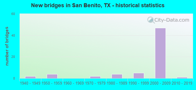
- New bridges - historical statistics
- 21940-1949
- 41950-1959
- 21970-1979
- 41980-1989
- 51990-1999
- 472000-2009
- 12010-2019
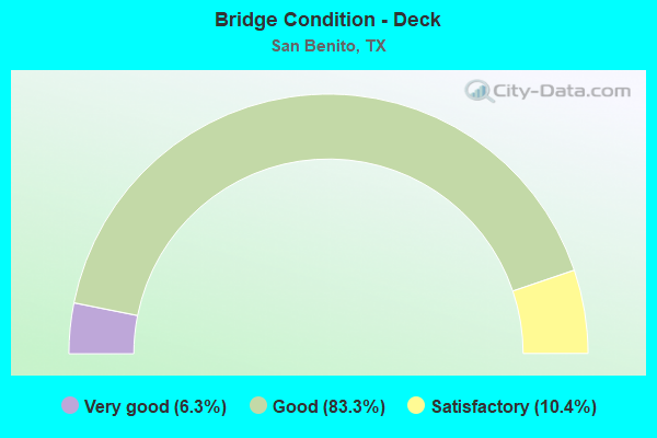
- Bridge Condition - Deck
- 6.3%Very good
- 83.3%Good
- 10.4%Satisfactory
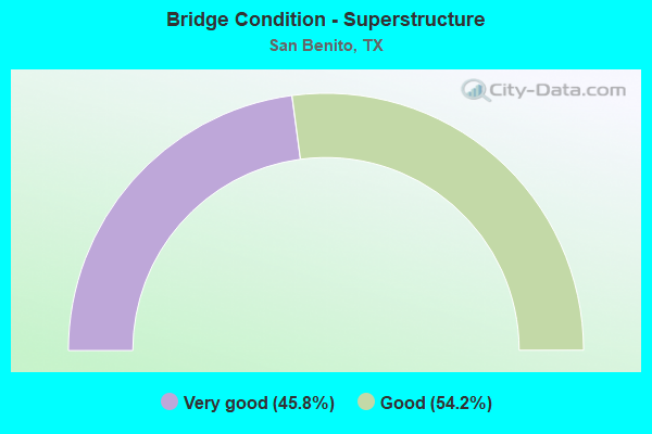
- Bridge Condition - Superstructure
- 45.8%Very good
- 54.2%Good
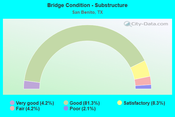
- Bridge Condition - Substructure
- 4.2%Very good
- 81.3%Good
- 8.3%Satisfactory
- 4.2%Fair
- 2.1%Poor
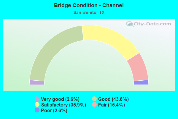
- Bridge Condition - Channel
- 2.6%Very good
- 43.6%Good
- 35.9%Satisfactory
- 15.4%Fair
- 2.6%Poor
Find on map >> Show street view
Structure Number: 21031000390733, Location: 1.50 MI SE OF FM 801 (Lat: 26.149800, Lng: -97.667031), Route carried "on" structure: US 77, Year Built: 2005, Status: Open, Structure Length: 6.95m (22.80ft), Average Daily Traffic: 29,090 (year 2011), Truck Traffic: 8%, Average Future Daily Traffic: 40,730 (year 2031), Design Load: HS 25 or greater, Features Intersected: FM 509 (HELEN MOORE RD)
Minimum Vertical Clearance: 30+ m (98+ ft), Kilometerpoint: 26.622, Lanes on structure: 3, Lanes under structure: 8, Owner: State Highway Agency, Approaching Roadway Width: 17.1m (56.1ft), Material/Design: Prestressed concrete, Design/Construction: Stringer/Multi-beam, Number Of Spans In Main Unit: 1, Number Of Approach Spans: 2, Length of Maximum Span: 35.4m (116.1ft), Curb-To-Curb Width: 17.1m (56.1ft), Out-to-Out Width: 18.0m (59.1ft)
Condition: Deck: Satisfactory, Superstructure: Good, Substructure: Good, Operating Rating: 68.0 metric tons, Method Used To Determine Operating Rating: Assigned rating based on Load Factor Design (LFD) reported in metric tons, Inventory Rating: 40.8 metric tons, Method Used To Determine Inventory Rating: Assigned rating based on Load Factor Design (LFD) reported in metric tons, Structural Evaluation: Better than present minimum criteria, Deck Geometry: Equal to present minimum criteria, Underclear: Equal to present minimum criteria, Approach Roadway Alignment: Equal to present desirable criteria, Designated Inspection Frequency: Every 24 months, Inspection Date: Febuary 2021, Deck Structure Type: Concrete Precast Panels
Find on map >> Show street view
Structure Number: 210310003907331, Location: 1.50 MI SE OF FM 801 (Lat: 26.149986, Lng: -97.667767), Route carried "on" structure: US 77, Year Built: 2004, Status: Open, Structure Length: 6.95m (22.80ft), Average Daily Traffic: 29,090 (year 2011), Truck Traffic: 8%, Average Future Daily Traffic: 40,730 (year 2031), Design Load: HS 25 or greater, Features Intersected: FM 509 (HELEN MOORE RD)
Minimum Vertical Clearance: 30+ m (98+ ft), Kilometerpoint: 26.622, Lanes on structure: 3, Lanes under structure: 8, Owner: State Highway Agency, Approaching Roadway Width: 17.1m (56.1ft), Material/Design: Prestressed concrete, Design/Construction: Stringer/Multi-beam, Number Of Spans In Main Unit: 1, Number Of Approach Spans: 2, Length of Maximum Span: 35.4m (116.1ft), Curb-To-Curb Width: 17.1m (56.1ft), Out-to-Out Width: 18.0m (59.1ft)
Condition: Deck: Satisfactory, Superstructure: Good, Substructure: Good, Operating Rating: 68.0 metric tons, Method Used To Determine Operating Rating: Assigned rating based on Load Factor Design (LFD) reported in metric tons, Inventory Rating: 40.8 metric tons, Method Used To Determine Inventory Rating: Assigned rating based on Load Factor Design (LFD) reported in metric tons, Structural Evaluation: Better than present minimum criteria, Deck Geometry: Equal to present minimum criteria, Underclear: Equal to present minimum criteria, Approach Roadway Alignment: Equal to present desirable criteria, Designated Inspection Frequency: Every 24 months, Inspection Date: Febuary 2021, Deck Structure Type: Concrete Precast Panels
Find on map >> Show street view
Structure Number: 210310003907362, Location: 1.50 MI NW OF FM 2520 (Lat: 26.140383, Lng: -97.655025), Route carried "on" structure: US 77, Year Built: 2005, Status: Open, Structure Length: 7.25m (23.79ft), Average Daily Traffic: 29,090 (year 2011), Truck Traffic: 8%, Average Future Daily Traffic: 40,730 (year 2031), Design Load: HS 25 or greater, Features Intersected: SPUR 486 (WILLIAMS RD)
Minimum Vertical Clearance: 30+ m (98+ ft), Kilometerpoint: 28.223, Lanes on structure: 3, Lanes under structure: 8, Owner: State Highway Agency, Approaching Roadway Width: 17.1m (56.1ft), Skew: 1 degrees, Material/Design: Prestressed concrete, Design/Construction: Stringer/Multi-beam, Number Of Spans In Main Unit: 1, Number Of Approach Spans: 2, Length of Maximum Span: 34.7m (113.8ft), Curb-To-Curb Width: 17.1m (56.1ft), Out-to-Out Width: 18.0m (59.1ft)
Condition: Deck: Good, Superstructure: Good, Substructure: Good, Operating Rating: 68.0 metric tons, Method Used To Determine Operating Rating: Assigned rating based on Load Factor Design (LFD) reported in metric tons, Inventory Rating: 40.8 metric tons, Method Used To Determine Inventory Rating: Assigned rating based on Load Factor Design (LFD) reported in metric tons, Structural Evaluation: Better than present minimum criteria, Deck Geometry: Equal to present minimum criteria, Underclear: Equal to present minimum criteria, Approach Roadway Alignment: Equal to present desirable criteria, Designated Inspection Frequency: Every 24 months, Inspection Date: Febuary 2021, Deck Structure Type: Concrete Precast Panels
Find on map >> Show street view
Structure Number: 210310003907363, Location: 1.50 MI NW OF FM 2520 (Lat: 26.140511, Lng: -97.655556), Route carried "on" structure: US 77, Year Built: 2005, Status: Open, Structure Length: 7.25m (23.79ft), Average Daily Traffic: 29,090 (year 2011), Truck Traffic: 8%, Average Future Daily Traffic: 40,730 (year 2031), Design Load: HS 25 or greater, Features Intersected: SPUR 486 (WILLIAMS RD)
Minimum Vertical Clearance: 30+ m (98+ ft), Kilometerpoint: 28.223, Lanes on structure: 3, Lanes under structure: 8, Owner: State Highway Agency, Approaching Roadway Width: 17.1m (56.1ft), Skew: 1 degrees, Material/Design: Prestressed concrete, Design/Construction: Stringer/Multi-beam, Number Of Spans In Main Unit: 1, Number Of Approach Spans: 2, Length of Maximum Span: 34.7m (113.8ft), Curb-To-Curb Width: 17.1m (56.1ft), Out-to-Out Width: 18.0m (59.1ft)
Condition: Deck: Good, Superstructure: Good, Substructure: Good, Operating Rating: 68.0 metric tons, Method Used To Determine Operating Rating: Assigned rating based on Load Factor Design (LFD) reported in metric tons, Inventory Rating: 40.8 metric tons, Method Used To Determine Inventory Rating: Assigned rating based on Load Factor Design (LFD) reported in metric tons, Structural Evaluation: Better than present minimum criteria, Deck Geometry: Equal to present minimum criteria, Underclear: Equal to present minimum criteria, Approach Roadway Alignment: Equal to present desirable criteria, Designated Inspection Frequency: Every 24 months, Inspection Date: Febuary 2021, Deck Structure Type: Concrete Precast Panels
Find on map >> Show street view
Structure Number: 210310003907364, Location: 1.00 MI NW OF FM 2520 (Lat: 26.135567, Lng: -97.648906), Route carried "on" structure: US 77, Year Built: 2005, Status: Open, Structure Length: 6.28m (20.60ft), Average Daily Traffic: 30,150 (year 2011), Truck Traffic: 8%, Average Future Daily Traffic: 44,520 (year 2031), Design Load: HS 25 or greater, Features Intersected: RATLIFF ST
Minimum Vertical Clearance: 30+ m (98+ ft), Kilometerpoint: 29.037, Lanes on structure: 3, Lanes under structure: 6, Owner: State Highway Agency, Approaching Roadway Width: 17.1m (56.1ft), Material/Design: Prestressed concrete, Design/Construction: Stringer/Multi-beam, Number Of Spans In Main Unit: 1, Number Of Approach Spans: 2, Length of Maximum Span: 29.0m (95.1ft), Curb-To-Curb Width: 17.6m (57.7ft), Out-to-Out Width: 18.5m (60.7ft)
Condition: Deck: Good, Superstructure: Very good, Substructure: Good, Operating Rating: 68.0 metric tons, Method Used To Determine Operating Rating: Assigned rating based on Load Factor Design (LFD) reported in metric tons, Inventory Rating: 40.8 metric tons, Method Used To Determine Inventory Rating: Assigned rating based on Load Factor Design (LFD) reported in metric tons, Structural Evaluation: Better than present minimum criteria, Deck Geometry: Better than present minimum criteria, Underclear: Superior to present desirable criteria, Approach Roadway Alignment: Equal to present desirable criteria, Designated Inspection Frequency: Every 24 months, Inspection Date: Febuary 2021, Deck Structure Type: Concrete Precast Panels
Find on map >> Show street view
Structure Number: 210310003907365, Location: 1.00 MI NW OF FM 2520 (Lat: 26.135669, Lng: -97.649439), Route carried "on" structure: US 77, Year Built: 2005, Status: Open, Structure Length: 6.28m (20.60ft), Average Daily Traffic: 30,150 (year 2011), Truck Traffic: 8%, Average Future Daily Traffic: 44,520 (year 2031), Design Load: HS 25 or greater, Features Intersected: RATLIFF ST
Minimum Vertical Clearance: 30+ m (98+ ft), Kilometerpoint: 29.037, Lanes on structure: 3, Lanes under structure: 6, Owner: State Highway Agency, Approaching Roadway Width: 17.1m (56.1ft), Material/Design: Prestressed concrete, Design/Construction: Stringer/Multi-beam, Number Of Spans In Main Unit: 1, Number Of Approach Spans: 2, Length of Maximum Span: 29.0m (95.1ft), Curb-To-Curb Width: 17.6m (57.7ft), Out-to-Out Width: 18.5m (60.7ft)
Condition: Deck: Good, Superstructure: Very good, Substructure: Good, Operating Rating: 68.0 metric tons, Method Used To Determine Operating Rating: Assigned rating based on Load Factor Design (LFD) reported in metric tons, Inventory Rating: 40.8 metric tons, Method Used To Determine Inventory Rating: Assigned rating based on Load Factor Design (LFD) reported in metric tons, Structural Evaluation: Better than present minimum criteria, Deck Geometry: Better than present minimum criteria, Underclear: Superior to present desirable criteria, Approach Roadway Alignment: Equal to present desirable criteria, Designated Inspection Frequency: Every 24 months, Inspection Date: Febuary 2021, Deck Structure Type: Concrete Precast Panels
Find on map >> Show street view
Structure Number: 210310003907366, Location: 0.50 MI NW OF FM 2520 (Lat: 26.130925, Lng: -97.642308), Route carried "on" structure: US 77, Year Built: 2005, Status: Open, Structure Length: 7.19m (23.59ft), Average Daily Traffic: 30,150 (year 2011), Truck Traffic: 8%, Average Future Daily Traffic: 44,520 (year 2031), Design Load: HS 25 or greater, Features Intersected: RESACA DE LOS FRESNOS
Minimum Vertical Clearance: 30+ m (98+ ft), Kilometerpoint: 29.868, Lanes on structure: 3, Owner: State Highway Agency, Approaching Roadway Width: 18.3m (60.0ft), Skew: 4 degrees, Material/Design: Prestressed concrete, Design/Construction: Stringer/Multi-beam, Number Of Spans In Main Unit: 1, Number Of Approach Spans: 2, Length of Maximum Span: 36.6m (120.1ft), Curb-To-Curb Width: 18.5m (60.7ft), Out-to-Out Width: 19.4m (63.6ft)
Condition: Deck: Good, Superstructure: Very good, Substructure: Good, Channel: Fair, Operating Rating: 68.0 metric tons, Method Used To Determine Operating Rating: Assigned rating based on Load Factor Design (LFD) reported in metric tons, Inventory Rating: 40.8 metric tons, Method Used To Determine Inventory Rating: Assigned rating based on Load Factor Design (LFD) reported in metric tons, Structural Evaluation: Better than present minimum criteria, Deck Geometry: Superior to present desirable criteria, Waterway Adequacy: Superior to present desirable criteria, Approach Roadway Alignment: Equal to present desirable criteria, Designated Inspection Frequency: Every 24 months, Inspection Date: Febuary 2021, Deck Structure Type: Concrete Precast Panels
Find on map >> Show street view
Structure Number: 210310003907367, Location: 0.50 MI NW OF FM 2520 (Lat: 26.131036, Lng: -97.643086), Route carried "on" structure: US 77, Year Built: 2005, Status: Open, Structure Length: 7.19m (23.59ft), Average Daily Traffic: 30,150 (year 2011), Truck Traffic: 8%, Average Future Daily Traffic: 44,520 (year 2031), Design Load: HS 25 or greater, Features Intersected: RESACA DE LOS FRESNOS
Minimum Vertical Clearance: 30+ m (98+ ft), Kilometerpoint: 29.868, Lanes on structure: 4, Owner: State Highway Agency, Approaching Roadway Width: 20.7m (67.9ft), Skew: 4 degrees, Material/Design: Prestressed concrete, Design/Construction: Stringer/Multi-beam, Number Of Spans In Main Unit: 1, Number Of Approach Spans: 2, Length of Maximum Span: 36.6m (120.1ft), Curb-To-Curb Width: 20.7m (67.9ft), Out-to-Out Width: 21.6m (70.9ft)
Condition: Deck: Good, Superstructure: Good, Substructure: Good, Channel: Satisfactory, Operating Rating: 68.0 metric tons, Method Used To Determine Operating Rating: Assigned rating based on Load Factor Design (LFD) reported in metric tons, Inventory Rating: 40.8 metric tons, Method Used To Determine Inventory Rating: Assigned rating based on Load Factor Design (LFD) reported in metric tons, Structural Evaluation: Better than present minimum criteria, Deck Geometry: Equal to present minimum criteria, Waterway Adequacy: Superior to present desirable criteria, Approach Roadway Alignment: Equal to present desirable criteria, Designated Inspection Frequency: Every 24 months, Inspection Date: Febuary 2021, Deck Structure Type: Concrete Precast Panels
Find on map >> Show street view
Structure Number: 210310003907368, Location: 2.10 MI NW OF FM 732 (Lat: 26.126492, Lng: -97.636203), Route carried "on" structure: US 77, Year Built: 2005, Status: Open, Structure Length: 6.40m (21.00ft), Average Daily Traffic: 30,150 (year 2011), Truck Traffic: 8%, Average Future Daily Traffic: 44,520 (year 2031), Design Load: HS 25 or greater, Features Intersected: SH 345 (SAM HOUSTON ST)
Minimum Vertical Clearance: 30+ m (98+ ft), Kilometerpoint: 30.644, Lanes on structure: 3, Lanes under structure: 8, Owner: State Highway Agency, Approaching Roadway Width: 17.1m (56.1ft), Material/Design: Prestressed concrete, Design/Construction: Stringer/Multi-beam, Number Of Spans In Main Unit: 1, Number Of Approach Spans: 2, Length of Maximum Span: 34.1m (111.9ft), Curb-To-Curb Width: 17.3m (56.8ft), Out-to-Out Width: 18.0m (59.1ft)
Condition: Deck: Good, Superstructure: Very good, Substructure: Good, Operating Rating: 68.0 metric tons, Method Used To Determine Operating Rating: Assigned rating based on Load Factor Design (LFD) reported in metric tons, Inventory Rating: 40.8 metric tons, Method Used To Determine Inventory Rating: Assigned rating based on Load Factor Design (LFD) reported in metric tons, Structural Evaluation: Better than present minimum criteria, Deck Geometry: Better than present minimum criteria, Underclear: Equal to present minimum criteria, Approach Roadway Alignment: Equal to present desirable criteria, Designated Inspection Frequency: Every 24 months, Inspection Date: Febuary 2021, Deck Structure Type: Concrete Precast Panels
Find on map >> Show street view
Structure Number: 210310003907369, Location: 2.10 MI NW OF FM 732 (Lat: 26.126611, Lng: -97.636794), Route carried "on" structure: US 77, Year Built: 2005, Status: Open, Structure Length: 6.40m (21.00ft), Average Daily Traffic: 30,150 (year 2011), Truck Traffic: 8%, Average Future Daily Traffic: 44,520 (year 2031), Design Load: HS 25 or greater, Features Intersected: SH 345 (SAM HOUSTON ST)
Minimum Vertical Clearance: 30+ m (98+ ft), Kilometerpoint: 30.644, Lanes on structure: 3, Lanes under structure: 8, Owner: State Highway Agency, Approaching Roadway Width: 17.1m (56.1ft), Material/Design: Prestressed concrete, Design/Construction: Stringer/Multi-beam, Number Of Spans In Main Unit: 1, Number Of Approach Spans: 2, Length of Maximum Span: 34.1m (111.9ft), Curb-To-Curb Width: 17.3m (56.8ft), Out-to-Out Width: 18.0m (59.1ft)
Condition: Deck: Good, Superstructure: Very good, Substructure: Good, Operating Rating: 68.0 metric tons, Method Used To Determine Operating Rating: Assigned rating based on Load Factor Design (LFD) reported in metric tons, Inventory Rating: 40.8 metric tons, Method Used To Determine Inventory Rating: Assigned rating based on Load Factor Design (LFD) reported in metric tons, Structural Evaluation: Better than present minimum criteria, Deck Geometry: Better than present minimum criteria, Underclear: Equal to present minimum criteria, Approach Roadway Alignment: Equal to present desirable criteria, Designated Inspection Frequency: Every 24 months, Inspection Date: Febuary 2021, Deck Structure Type: Concrete Precast Panels
Find on map >> Show street view
Structure Number: 21031000390737, Location: 0.50 MI SE OF SH 345 (Lat: 26.122025, Lng: -97.630603), Route carried "on" structure: US 77, Year Built: 2005, Status: Open, Structure Length: 6.07m (19.91ft), Average Daily Traffic: 25,650 (year 2011), Truck Traffic: 8%, Average Future Daily Traffic: 38,350 (year 2031), Design Load: HS 25 or greater, Features Intersected: McCulloch St
Minimum Vertical Clearance: 30+ m (98+ ft), Kilometerpoint: 31.450, Lanes on structure: 3, Lanes under structure: 6, Owner: State Highway Agency, Approaching Roadway Width: 17.1m (56.1ft), Material/Design: Prestressed concrete, Design/Construction: Stringer/Multi-beam, Number Of Spans In Main Unit: 1, Number Of Approach Spans: 2, Length of Maximum Span: 29.0m (95.1ft), Curb-To-Curb Width: 17.3m (56.8ft), Out-to-Out Width: 18.0m (59.1ft)
Condition: Deck: Good, Superstructure: Good, Substructure: Good, Operating Rating: 68.0 metric tons, Method Used To Determine Operating Rating: Assigned rating based on Load Factor Design (LFD) reported in metric tons, Inventory Rating: 40.8 metric tons, Method Used To Determine Inventory Rating: Assigned rating based on Load Factor Design (LFD) reported in metric tons, Structural Evaluation: Better than present minimum criteria, Deck Geometry: Better than present minimum criteria, Underclear: Superior to present desirable criteria, Approach Roadway Alignment: Equal to present desirable criteria, Designated Inspection Frequency: Every 24 months, Inspection Date: Febuary 2021, Deck Structure Type: Concrete Precast Panels
Find on map >> Show street view
Structure Number: 210310003907371, Location: 0.50 MI SE OF SH 345 (Lat: 26.121917, Lng: -97.629964), Route carried "on" structure: US 77, Year Built: 2005, Status: Open, Structure Length: 6.07m (19.91ft), Average Daily Traffic: 25,650 (year 2011), Truck Traffic: 8%, Average Future Daily Traffic: 38,350 (year 2031), Design Load: HS 25 or greater, Features Intersected: McCulloch St
Minimum Vertical Clearance: 30+ m (98+ ft), Kilometerpoint: 31.450, Lanes on structure: 3, Lanes under structure: 6, Owner: State Highway Agency, Approaching Roadway Width: 17.1m (56.1ft), Material/Design: Prestressed concrete, Design/Construction: Stringer/Multi-beam, Number Of Spans In Main Unit: 1, Number Of Approach Spans: 2, Length of Maximum Span: 29.0m (95.1ft), Curb-To-Curb Width: 17.3m (56.8ft), Out-to-Out Width: 18.0m (59.1ft)
Condition: Deck: Good, Superstructure: Very good, Substructure: Good, Operating Rating: 68.0 metric tons, Method Used To Determine Operating Rating: Assigned rating based on Load Factor Design (LFD) reported in metric tons, Inventory Rating: 40.8 metric tons, Method Used To Determine Inventory Rating: Assigned rating based on Load Factor Design (LFD) reported in metric tons, Structural Evaluation: Better than present minimum criteria, Deck Geometry: Better than present minimum criteria, Underclear: Superior to present desirable criteria, Approach Roadway Alignment: Equal to present desirable criteria, Designated Inspection Frequency: Every 24 months, Inspection Date: Febuary 2021, Deck Structure Type: Concrete Precast Panels
Find on map >> Show street view
Structure Number: 210310003907372, Location: 1.52 MI SE OF SH 345 (Lat: 26.113942, Lng: -97.617125), Route carried "on" structure: US 77, Year Built: 2005, Status: Open, Structure Length: 7.10m (23.29ft), Average Daily Traffic: 22,880 (year 2011), Truck Traffic: 9%, Average Future Daily Traffic: 32,030 (year 2031), Design Load: HS 25 or greater, Features Intersected: LINE M RD
Minimum Vertical Clearance: 30+ m (98+ ft), Kilometerpoint: 33.075, Lanes on structure: 3, Lanes under structure: 8, Owner: State Highway Agency, Approaching Roadway Width: 17.1m (56.1ft), Skew: 1 degrees, Material/Design: Prestressed concrete, Design/Construction: Stringer/Multi-beam, Number Of Spans In Main Unit: 1, Number Of Approach Spans: 2, Length of Maximum Span: 35.7m (117.1ft), Curb-To-Curb Width: 17.1m (56.1ft), Out-to-Out Width: 18.0m (59.1ft)
Condition: Deck: Good, Superstructure: Very good, Substructure: Good, Operating Rating: 68.0 metric tons, Method Used To Determine Operating Rating: Assigned rating based on Load Factor Design (LFD) reported in metric tons, Inventory Rating: 40.8 metric tons, Method Used To Determine Inventory Rating: Assigned rating based on Load Factor Design (LFD) reported in metric tons, Structural Evaluation: Better than present minimum criteria, Deck Geometry: Equal to present minimum criteria, Underclear: Better than present minimum criteria, Approach Roadway Alignment: Equal to present desirable criteria, Designated Inspection Frequency: Every 24 months, Inspection Date: Febuary 2021, Deck Structure Type: Concrete Precast Panels
Find on map >> Show street view
Structure Number: 210310003907373, Location: 1.52 MI SE OF SH 345 (Lat: 26.113597, Lng: -97.617269), Route carried "on" structure: US 77, Year Built: 2005, Status: Open, Structure Length: 7.10m (23.29ft), Average Daily Traffic: 22,880 (year 2011), Truck Traffic: 9%, Average Future Daily Traffic: 32,030 (year 2031), Design Load: HS 25 or greater, Features Intersected: LINE M RD
Minimum Vertical Clearance: 30+ m (98+ ft), Kilometerpoint: 33.075, Lanes on structure: 3, Lanes under structure: 8, Owner: State Highway Agency, Approaching Roadway Width: 17.1m (56.1ft), Skew: 1 degrees, Material/Design: Prestressed concrete, Design/Construction: Stringer/Multi-beam, Number Of Spans In Main Unit: 1, Number Of Approach Spans: 2, Length of Maximum Span: 35.7m (117.1ft), Curb-To-Curb Width: 17.1m (56.1ft), Out-to-Out Width: 18.0m (59.1ft)
Condition: Deck: Good, Superstructure: Very good, Substructure: Good, Operating Rating: 68.0 metric tons, Method Used To Determine Operating Rating: Assigned rating based on Load Factor Design (LFD) reported in metric tons, Inventory Rating: 40.8 metric tons, Method Used To Determine Inventory Rating: Assigned rating based on Load Factor Design (LFD) reported in metric tons, Structural Evaluation: Better than present minimum criteria, Deck Geometry: Equal to present minimum criteria, Underclear: Superior to present desirable criteria, Approach Roadway Alignment: Equal to present desirable criteria, Designated Inspection Frequency: Every 24 months, Inspection Date: Febuary 2021, Deck Structure Type: Concrete Precast Panels
Find on map >> Show street view
Structure Number: 210310003907374, Location: 0.7 MI NW OF FM 2520 (Lat: 26.132286, Lng: -97.645667), Route carried "on" structure: ServiceUS 77, Year Built: 2006, Status: Open, Structure Length: 4.02m (13.19ft), Average Daily Traffic: 3,140 (year 2011), Truck Traffic: 3%, Average Future Daily Traffic: 4,400 (year 2031), Design Load: HS 25 or greater, Features Intersected: RESACA DE LOS FRESNOS
Minimum Vertical Clearance: 30+ m (98+ ft), Kilometerpoint: 29.572, Lanes on structure: 3, Owner: State Highway Agency, Approaching Roadway Width: 12.2m (40.0ft), Skew: 4 degrees, Material/Design: Prestressed concrete, Design/Construction: Stringer/Multi-beam, Number Of Spans In Main Unit: 3, Length of Maximum Span: 13.4m (44.0ft), Curb or Sidewalk Widths: Left: 1.8m (5.9ft), Right: 0.0m, Curb-To-Curb Width: 12.3m (40.4ft), Out-to-Out Width: 14.9m (48.9ft)
Condition: Deck: Good, Superstructure: Very good, Substructure: Good, Channel: Fair, Operating Rating: 68.0 metric tons, Method Used To Determine Operating Rating: Assigned rating based on Load Factor Design (LFD) reported in metric tons, Inventory Rating: 40.8 metric tons, Method Used To Determine Inventory Rating: Assigned rating based on Load Factor Design (LFD) reported in metric tons, Structural Evaluation: Better than present minimum criteria, Deck Geometry: Meets minimum limits, Waterway Adequacy: Better than present minimum criteria, Approach Roadway Alignment: Equal to present desirable criteria, Designated Inspection Frequency: Every 24 months, Underwater Inspection Frequency: Every 60 months, Inspection Date: Febuary 2021, Underwater Inspection Date: January 2017, Deck Structure Type: Concrete Precast Panels
Find on map >> Show street view
Structure Number: 210310003907375, Location: 0.50 MI NW OF FM 2520 (Lat: 26.130933, Lng: -97.641856), Route carried "on" structure: ServiceUS 77, Year Built: 2007, Status: Open, Structure Length: 4.02m (13.19ft), Average Daily Traffic: 2,960 (year 2011), Truck Traffic: 3%, Average Future Daily Traffic: 4,140 (year 2031), Design Load: HS 25 or greater, Features Intersected: RESACA DE LOS FRESNOS
Minimum Vertical Clearance: 30+ m (98+ ft), Kilometerpoint: 29.919, Lanes on structure: 3, Owner: State Highway Agency, Approaching Roadway Width: 12.2m (40.0ft), Skew: 4 degrees, Material/Design: Prestressed concrete, Design/Construction: Stringer/Multi-beam, Number Of Spans In Main Unit: 3, Length of Maximum Span: 13.4m (44.0ft), Curb or Sidewalk Widths: Left: 0.0m, Right: 1.8m (5.9ft), Curb-To-Curb Width: 12.3m (40.4ft), Out-to-Out Width: 14.9m (48.9ft)
Condition: Deck: Good, Superstructure: Very good, Substructure: Good, Channel: Fair, Operating Rating: 68.0 metric tons, Method Used To Determine Operating Rating: Assigned rating based on Load Factor Design (LFD) reported in metric tons, Inventory Rating: 40.8 metric tons, Method Used To Determine Inventory Rating: Assigned rating based on Load Factor Design (LFD) reported in metric tons, Structural Evaluation: Better than present minimum criteria, Deck Geometry: Meets minimum limits, Waterway Adequacy: Better than present minimum criteria, Approach Roadway Alignment: Equal to present desirable criteria, Designated Inspection Frequency: Every 24 months, Underwater Inspection Frequency: Every 60 months, Inspection Date: Febuary 2021, Underwater Inspection Date: January 2017, Deck Structure Type: Concrete Precast Panels
Find on map >> Show street view
Structure Number: 210310003907376, Location: 2.15 MI SE OF SH 345 (Lat: 26.109128, Lng: -97.604692), Route carried "on" structure: US 77, Year Built: 2005, Status: Open, Structure Length: 40.39m (132.51ft), Average Daily Traffic: 22,880 (year 2011), Truck Traffic: 9%, Average Future Daily Traffic: 32,030 (year 2031), Design Load: HS 25 or greater, Features Intersected: FM 732 UP RR US 77 BUS
Minimum Vertical Clearance: 30+ m (98+ ft), Kilometerpoint: 34.012, Lanes on structure: 3, Lanes under structure: 7, Owner: State Highway Agency, Approaching Roadway Width: 17.1m (56.1ft), Skew: 9 degrees, Material/Design: Steel continuous, Design/Construction: Stringer/Multi-beam, Number Of Spans In Main Unit: 3, Number Of Approach Spans: 8, Length of Maximum Span: 71.6m (234.9ft), Curb-To-Curb Width: 17.3m (56.8ft), Out-to-Out Width: 18.3m (60.0ft)
Condition: Deck: Satisfactory, Superstructure: Good, Substructure: Good, Channel: Good, Operating Rating: 68.0 metric tons, Method Used To Determine Operating Rating: Assigned rating based on Load Factor Design (LFD) reported in metric tons, Inventory Rating: 40.8 metric tons, Method Used To Determine Inventory Rating: Assigned rating based on Load Factor Design (LFD) reported in metric tons, Structural Evaluation: Better than present minimum criteria, Deck Geometry: Better than present minimum criteria, Underclear: Superior to present desirable criteria, Waterway Adequacy: Superior to present desirable criteria, Approach Roadway Alignment: Equal to present desirable criteria, Designated Inspection Frequency: Every 24 months, Inspection Date: Febuary 2021, Deck Structure Type: Concrete Precast Panels
Find on map >> Show street view
Structure Number: 210310003907377, Location: 2.15 MI SE OF SH 345 (Lat: 26.109497, Lng: -97.604925), Route carried "on" structure: US 77, Year Built: 2005, Status: Open, Structure Length: 40.39m (132.51ft), Average Daily Traffic: 22,880 (year 2011), Truck Traffic: 9%, Average Future Daily Traffic: 32,030 (year 2031), Design Load: HS 25 or greater, Features Intersected: FM 732 UP RR US 77 BUS
Minimum Vertical Clearance: 30+ m (98+ ft), Kilometerpoint: 34.012, Lanes on structure: 3, Lanes under structure: 7, Owner: State Highway Agency, Approaching Roadway Width: 17.1m (56.1ft), Skew: 9 degrees, Material/Design: Steel continuous, Design/Construction: Stringer/Multi-beam, Number Of Spans In Main Unit: 3, Number Of Approach Spans: 8, Length of Maximum Span: 71.6m (234.9ft), Curb-To-Curb Width: 17.3m (56.8ft), Out-to-Out Width: 17.7m (58.1ft)
Condition: Deck: Satisfactory, Superstructure: Very good, Substructure: Good, Channel: Good, Operating Rating: 68.0 metric tons, Method Used To Determine Operating Rating: Assigned rating based on Load Factor Design (LFD) reported in metric tons, Inventory Rating: 40.8 metric tons, Method Used To Determine Inventory Rating: Assigned rating based on Load Factor Design (LFD) reported in metric tons, Structural Evaluation: Better than present minimum criteria, Deck Geometry: Better than present minimum criteria, Underclear: Better than present minimum criteria, Waterway Adequacy: Superior to present desirable criteria, Approach Roadway Alignment: Equal to present desirable criteria, Designated Inspection Frequency: Every 24 months, Inspection Date: Febuary 2021, Deck Structure Type: Concrete Precast Panels
Find on map >> Show street view
Structure Number: 210310003912032, Location: 0.95 Mi NW of SH 345 (Lat: 26.146611, Lng: -97.638133), Route carried "on" structure: Business State highway 77, Year Built: 1946, Year Reconstructed: 1969, Status: Open, Structure Length: 1.52m (4.99ft), Average Daily Traffic: 15,341 (year 2020), Truck Traffic: 1%, Average Future Daily Traffic: 23,160 (year 2033), Design Load: H 20, Features Intersected: Drainage Ditch
Minimum Vertical Clearance: 30+ m (98+ ft), Kilometerpoint: 28.183, Lanes on structure: 4, Owner: State Highway Agency, Approaching Roadway Width: 26.2m (86.0ft), Skew: 20 degrees, Material/Design: Concrete continuous, Design/Construction: Slab, Number Of Spans In Main Unit: 2, Length of Maximum Span: 7.6m (24.9ft), Curb or Sidewalk Widths: Left: 1.8m (5.9ft), Right: 1.8m (5.9ft), Curb-To-Curb Width: 21.6m (70.9ft), Out-to-Out Width: 30.8m (101.0ft)
Condition: Deck: Good, Superstructure: Good, Substructure: Good, Channel: Fair, Operating Rating: 49.9 metric tons, Method Used To Determine Operating Rating: Load Factor (LF), Inventory Rating: 29.9 metric tons, Method Used To Determine Inventory Rating: Load Factor (LF), Structural Evaluation: Better than present minimum criteria, Deck Geometry: Superior to present desirable criteria, Waterway Adequacy: Equal to present minimum criteria, Approach Roadway Alignment: Equal to present desirable criteria, Designated Inspection Frequency: Every 24 months, Inspection Date: March 2021, Deck Structure Type: Concrete Cast-file-Place, Wearing Surface/Protective System: Wearing Surface: Bituminous
Find on map >> Show street view
Structure Number: 210310003912033, Location: 0.20 Mi NW of SH 345 (Lat: 26.140606, Lng: -97.629275), Route carried "on" structure: Business State highway 77, Year Built: 1946, Year Reconstructed: 1969, Status: Open, Structure Length: 1.52m (4.99ft), Average Daily Traffic: 16,540 (year 2013), Truck Traffic: 1%, Average Future Daily Traffic: 23,160 (year 2033), Design Load: H 20, Features Intersected: Resaca de los Fresnos
Minimum Vertical Clearance: 30+ m (98+ ft), Kilometerpoint: 29.285, Lanes on structure: 5, Owner: State Highway Agency, Approaching Roadway Width: 26.5m (86.9ft), Material/Design: Concrete continuous, Design/Construction: Slab, Number Of Spans In Main Unit: 2, Length of Maximum Span: 7.6m (24.9ft), Curb or Sidewalk Widths: Left: 1.8m (5.9ft), Right: 1.8m (5.9ft), Curb-To-Curb Width: 26.5m (86.9ft), Out-to-Out Width: 30.8m (101.0ft)
Condition: Deck: Good, Superstructure: Good, Substructure: Fair, Channel: Good, Operating Rating: 51.7 metric tons, Method Used To Determine Operating Rating: Load Factor (LF), Inventory Rating: 30.8 metric tons, Method Used To Determine Inventory Rating: Load Factor (LF), Structural Evaluation: Somewhat better than minimum adequacy, Deck Geometry: Superior to present desirable criteria, Waterway Adequacy: Equal to present minimum criteria, Approach Roadway Alignment: Equal to present desirable criteria, Designated Inspection Frequency: Every 24 months, Underwater Inspection Frequency: Every 60 months, Inspection Date: March 2021, Underwater Inspection Date: September 2019, Deck Structure Type: Concrete Cast-file-Place, Wearing Surface/Protective System: Wearing Surface: Bituminous
Find on map >> Show street view
Structure Number: 210310003912034, Location: 0.01 Mi S of FM 732 (Lat: 26.112008, Lng: -97.606286), Route carried "on" structure: Business State highway 77, Year Built: 1950, Status: Open, Structure Length: 1.52m (4.99ft), Average Daily Traffic: 9,107 (year 2018), Truck Traffic: 1%, Average Future Daily Traffic: 4,790 (year 2033), Design Load: H 20, Features Intersected: Drainage Ditch
Minimum Vertical Clearance: 30+ m (98+ ft), Kilometerpoint: 33.378, Lanes on structure: 2, Owner: State Highway Agency, Approaching Roadway Width: 11.6m (38.1ft), Skew: 3 degrees, Material/Design: Concrete, Design/Construction: Slab, Number Of Spans In Main Unit: 2, Length of Maximum Span: 7.6m (24.9ft), Curb-To-Curb Width: 11.5m (37.7ft), Out-to-Out Width: 12.2m (40.0ft)
Condition: Deck: Good, Superstructure: Good, Substructure: Good, Channel: Good, Operating Rating: 68.0 metric tons, Method Used To Determine Operating Rating: Load Factor (LF), Inventory Rating: 36.3 metric tons, Method Used To Determine Inventory Rating: Load Factor (LF), Structural Evaluation: Better than present minimum criteria, Deck Geometry: Equal to present minimum criteria, Waterway Adequacy: Equal to present minimum criteria, Approach Roadway Alignment: Equal to present desirable criteria, Designated Inspection Frequency: Every 24 months, Inspection Date: March 2021, Deck Structure Type: Concrete Cast-file-Place, Wearing Surface/Protective System: Wearing Surface: Bituminous
Find on map >> Show street view
Structure Number: 21031000391205, Location: 0.01 Mi S of FM 732 (Lat: 26.112072, Lng: -97.606083), Route carried "on" structure: Business State highway 77, Year Built: 1958, Status: Open, Structure Length: 2.32m (7.61ft), Average Daily Traffic: 9,107 (year 2018), Truck Traffic: 1%, Average Future Daily Traffic: 4,790 (year 2033), Features Intersected: Drainage Ditch
Minimum Vertical Clearance: 30+ m (98+ ft), Kilometerpoint: 33.352, Lanes on structure: 2, Owner: State Highway Agency, Approaching Roadway Width: 11.6m (38.1ft), Skew: 3 degrees, Material/Design: Concrete, Design/Construction: Slab, Number Of Spans In Main Unit: 3, Length of Maximum Span: 7.6m (24.9ft), Curb-To-Curb Width: 11.4m (37.4ft), Out-to-Out Width: 12.2m (40.0ft)
Condition: Deck: Good, Superstructure: Good, Substructure: Good, Channel: Good, Operating Rating: 49.0 metric tons, Method Used To Determine Operating Rating: Load Factor (LF), Inventory Rating: 29.0 metric tons, Method Used To Determine Inventory Rating: Load Factor (LF), Structural Evaluation: Better than present minimum criteria, Deck Geometry: Equal to present minimum criteria, Waterway Adequacy: Equal to present minimum criteria, Approach Roadway Alignment: Equal to present desirable criteria, Designated Inspection Frequency: Every 24 months, Inspection Date: March 2021, Deck Structure Type: Concrete Cast-file-Place, Wearing Surface/Protective System: Wearing Surface: Bituminous
Find on map >> Show street view
Structure Number: 21031000391228, Location: 0.75 MI NW OF SH 345 (Lat: 26.148761, Lng: -97.641517), Route carried "on" structure: Business State highway 77, Year Built: 1997, Status: Open, Structure Length: 0.67m (2.20ft), Average Daily Traffic: 21,820 (year 2013), Truck Traffic: 2%, Average Future Daily Traffic: 30,550 (year 2033), Features Intersected: DRAINAGE DITCH
Minimum Vertical Clearance: 30+ m (98+ ft), Kilometerpoint: 27.640, Lanes on structure: 4, Owner: State Highway Agency, Approaching Roadway Width: 26.8m (87.9ft), Material/Design: Concrete, Design/Construction: Culvert, Number Of Spans In Main Unit: 2, Length of Maximum Span: 3.0m (9.8ft)
Condition: Channel: Good, Culverts: Good, Operating Rating: 32.7 metric tons, Method Used To Determine Operating Rating: Field evaluation and documented engineering judgment, Inventory Rating: 24.5 metric tons, Method Used To Determine Inventory Rating: Field evaluation and documented engineering judgment, Structural Evaluation: Equal to present minimum criteria, Waterway Adequacy: Equal to present minimum criteria, Approach Roadway Alignment: Equal to present desirable criteria, Designated Inspection Frequency: Every 24 months, Inspection Date: March 2021
Find on map >> Show street view
Structure Number: 210310063001344, Location: 0.45 MI NE OF BUS 77 (Lat: 26.143756, Lng: -97.621278), Route carried "on" structure: State highway 345, Year Built: 2009, Status: Open, Structure Length: 3.05m (10.01ft), Average Daily Traffic: 5,046 (year 2020), Truck Traffic: 15%, Average Future Daily Traffic: 10,300 (year 2033), Design Load: HL 93, Features Intersected: RESACA DE LOS FRESNOS
Minimum Vertical Clearance: 30+ m (98+ ft), Kilometerpoint: 11.676, Lanes on structure: 4, Owner: State Highway Agency, Approaching Roadway Width: 20.7m (67.9ft), Skew: 23 degrees, Material/Design: Prestressed concrete, Design/Construction: Slab, Number Of Spans In Main Unit: 2, Length of Maximum Span: 15.2m (49.9ft), Curb-To-Curb Width: 20.6m (67.6ft), Out-to-Out Width: 26.2m (86.0ft)
Condition: Deck: Good, Superstructure: Very good, Substructure: Good, Channel: Good, Operating Rating: 54.4 metric tons, Method Used To Determine Operating Rating: Assigned ratings based on Load and Resistance Factor Design (LRFD) reported in metric tons, Inventory Rating: 32.7 metric tons, Method Used To Determine Inventory Rating: Assigned ratings based on Load and Resistance Factor Design (LRFD) reported in metric tons, Structural Evaluation: Better than present minimum criteria, Deck Geometry: Superior to present desirable criteria, Waterway Adequacy: Equal to present minimum criteria, Approach Roadway Alignment: Equal to present desirable criteria, Designated Inspection Frequency: Every 24 months, Underwater Inspection Frequency: Every 60 months, Inspection Date: March 2021, Underwater Inspection Date: January 2017, Deck Structure Type: Concrete Cast-file-Place
Find on map >> Show street view
Structure Number: 210310063001345, Location: 1.7 MI NE OF BUS 77 (Lat: 26.157561, Lng: -97.610450), Route carried "on" structure: State highway 345, Year Built: 2009, Status: Open, Structure Length: 3.05m (10.01ft), Average Daily Traffic: 5,046 (year 2020), Truck Traffic: 15%, Average Future Daily Traffic: 10,300 (year 2033), Design Load: HL 93, Features Intersected: RESACA DE LOS FRESNOS
Minimum Vertical Clearance: 30+ m (98+ ft), Kilometerpoint: 9.794, Lanes on structure: 4, Owner: State Highway Agency, Approaching Roadway Width: 25.6m (84.0ft), Material/Design: Prestressed concrete, Design/Construction: Slab, Number Of Spans In Main Unit: 2, Length of Maximum Span: 15.2m (49.9ft), Curb-To-Curb Width: 25.5m (83.7ft), Out-to-Out Width: 26.2m (86.0ft)
Condition: Deck: Good, Superstructure: Very good, Substructure: Good, Channel: Good, Operating Rating: 54.4 metric tons, Method Used To Determine Operating Rating: Assigned ratings based on Load and Resistance Factor Design (LRFD) reported in metric tons, Inventory Rating: 32.7 metric tons, Method Used To Determine Inventory Rating: Assigned ratings based on Load and Resistance Factor Design (LRFD) reported in metric tons, Structural Evaluation: Better than present minimum criteria, Deck Geometry: Superior to present desirable criteria, Waterway Adequacy: Equal to present minimum criteria, Approach Roadway Alignment: Equal to present desirable criteria, Designated Inspection Frequency: Every 24 months, Underwater Inspection Frequency: Every 60 months, Inspection Date: March 2021, Underwater Inspection Date: January 2017, Deck Structure Type: Concrete Cast-file-Place
Find on map >> Show street view
Structure Number: 210310063001346, Location: 0.65 MI NE OF BUS 77 (Lat: 26.145969, Lng: -97.619522), Route carried "on" structure: State highway 345, Year Built: 2009, Status: Open, Structure Length: 3.05m (10.01ft), Average Daily Traffic: 5,046 (year 2020), Truck Traffic: 15%, Average Future Daily Traffic: 10,300 (year 2033), Design Load: HL 93, Features Intersected: RESACA DE LOS FRESNOS
Minimum Vertical Clearance: 30+ m (98+ ft), Kilometerpoint: 11.388, Lanes on structure: 4, Owner: State Highway Agency, Approaching Roadway Width: 20.7m (67.9ft), Skew: 23 degrees, Material/Design: Prestressed concrete, Design/Construction: Slab, Number Of Spans In Main Unit: 2, Length of Maximum Span: 15.2m (49.9ft), Curb-To-Curb Width: 20.6m (67.6ft), Out-to-Out Width: 26.2m (86.0ft)
Condition: Deck: Good, Superstructure: Very good, Substructure: Good, Channel: Good, Operating Rating: 54.4 metric tons, Method Used To Determine Operating Rating: Assigned ratings based on Load and Resistance Factor Design (LRFD) reported in metric tons, Inventory Rating: 32.7 metric tons, Method Used To Determine Inventory Rating: Assigned ratings based on Load and Resistance Factor Design (LRFD) reported in metric tons, Structural Evaluation: Better than present minimum criteria, Deck Geometry: Superior to present desirable criteria, Waterway Adequacy: Equal to present minimum criteria, Approach Roadway Alignment: Equal to present desirable criteria, Designated Inspection Frequency: Every 24 months, Underwater Inspection Frequency: Every 60 months, Inspection Date: March 2021, Underwater Inspection Date: January 2017, Deck Structure Type: Concrete Cast-file-Place
Find on map >> Show street view
Structure Number: 210310105701005, Location: 1.85 MI NW OF FM 2520 (Lat: 26.087556, Lng: -97.710878), Route carried "on" structure: State highway 675, Year Built: 2007, Status: Open, Structure Length: 1.52m (4.99ft), Average Daily Traffic: 816 (year 2020), Truck Traffic: 16%, Average Future Daily Traffic: 1,170 (year 2033), Design Load: HS 20, Features Intersected: RIGHT HIGH LEVEL CANAL
Minimum Vertical Clearance: 30+ m (98+ ft), Kilometerpoint: 3.648, Lanes on structure: 2, Owner: State Highway Agency, Approaching Roadway Width: 8.5m (27.9ft), Material/Design: Prestressed concrete, Design/Construction: Box Beam or Girders - Multiple, Number Of Spans In Main Unit: 1, Length of Maximum Span: 15.2m (49.9ft), Curb-To-Curb Width: 13.3m (43.6ft), Out-to-Out Width: 14.1m (46.3ft)
Condition: Deck: Good, Superstructure: Very good, Substructure: Good, Channel: Good, Operating Rating: 54.4 metric tons, Method Used To Determine Operating Rating: Assigned rating based on Load Factor Design (LFD) reported in metric tons, Inventory Rating: 32.7 metric tons, Method Used To Determine Inventory Rating: Assigned rating based on Load Factor Design (LFD) reported in metric tons, Structural Evaluation: Better than present minimum criteria, Deck Geometry: Superior to present desirable criteria, Waterway Adequacy: Superior to present desirable criteria, Approach Roadway Alignment: Equal to present desirable criteria, Designated Inspection Frequency: Every 24 months, Inspection Date: March 2021, Deck Structure Type: Concrete Cast-file-Place
Find on map >> Show street view
Structure Number: 210310105701012, Location: 1.45 MI NW OF FM 2520 (Lat: 26.083825, Lng: -97.705989), Route carried "on" structure: State highway 675, Year Built: 2007, Status: Open, Structure Length: 1.83m (6.00ft), Average Daily Traffic: 816 (year 2020), Truck Traffic: 16%, Average Future Daily Traffic: 1,170 (year 2033), Design Load: HS 20, Features Intersected: LOW LINE CANAL
Minimum Vertical Clearance: 30+ m (98+ ft), Kilometerpoint: 4.291, Lanes on structure: 2, Owner: State Highway Agency, Approaching Roadway Width: 8.5m (27.9ft), Material/Design: Prestressed concrete, Design/Construction: Box Beam or Girders - Multiple, Number Of Spans In Main Unit: 2, Length of Maximum Span: 9.1m (29.9ft), Curb-To-Curb Width: 13.2m (43.3ft), Out-to-Out Width: 14.1m (46.3ft)
Condition: Deck: Good, Superstructure: Very good, Substructure: Good, Channel: Satisfactory, Operating Rating: 54.4 metric tons, Method Used To Determine Operating Rating: Assigned rating based on Load Factor Design (LFD) reported in metric tons, Inventory Rating: 32.7 metric tons, Method Used To Determine Inventory Rating: Assigned rating based on Load Factor Design (LFD) reported in metric tons, Structural Evaluation: Better than present minimum criteria, Deck Geometry: Superior to present desirable criteria, Waterway Adequacy: Superior to present desirable criteria, Approach Roadway Alignment: Equal to present desirable criteria, Designated Inspection Frequency: Every 24 months, Inspection Date: March 2021, Deck Structure Type: Concrete Cast-file-Place
Find on map >> Show street view
Structure Number: 210310105702006, Location: 2.00 MI NE OF US 281 (Lat: 26.067767, Lng: -97.645517), Route carried "on" structure: State highway 732, Year Built: 1951, Status: Open, Structure Length: 0.76m (2.49ft), Average Daily Traffic: 3,430 (year 2013), Truck Traffic: 17%, Average Future Daily Traffic: 4,800 (year 2033), Features Intersected: DRAINAGE DITCH
Minimum Vertical Clearance: 30+ m (98+ ft), Kilometerpoint: 6.354, Lanes on structure: 2, Owner: State Highway Agency, Approaching Roadway Width: 7.3m (24.0ft), Material/Design: Concrete, Design/Construction: Slab, Number Of Spans In Main Unit: 1, Length of Maximum Span: 7.6m (24.9ft), Curb-To-Curb Width: 7.1m (23.3ft), Out-to-Out Width: 7.7m (25.3ft)
Condition: Deck: Good, Superstructure: Good, Substructure: Very good, Channel: Satisfactory, Operating Rating: 52.6 metric tons, Method Used To Determine Operating Rating: Load Factor (LF), Inventory Rating: 27.2 metric tons, Method Used To Determine Inventory Rating: Load Factor (LF), Structural Evaluation: Equal to present minimum criteria, Deck Geometry: High priority of replacement, Waterway Adequacy: Equal to present minimum criteria, Approach Roadway Alignment: Equal to present desirable criteria, Length Of Structure Improvement: 0.76m (2.49ft), Designated Inspection Frequency: Every 24 months, Inspection Date: March 2021, Bridge Improvement Cost: $1,000, Total Project Cost: $1,000, Deck Structure Type: Concrete Cast-file-Place, Wearing Surface/Protective System: Wearing Surface: Bituminous
Find on map >> Show street view
Structure Number: 210310105702018, Location: 0.10 Mi NE of US 77 (Lat: 26.111044, Lng: -97.607458), Route carried "on" structure: State highway 732, Year Built: 1958, Status: Open, Structure Length: 1.52m (4.99ft), Average Daily Traffic: 7,166 (year 2020), Truck Traffic: 23%, Average Future Daily Traffic: 7,560 (year 2030), Features Intersected: Drainage Ditch
Minimum Vertical Clearance: 30+ m (98+ ft), Kilometerpoint: 0.167, Lanes on structure: 2, Owner: State Highway Agency, Approaching Roadway Width: 7.9m (25.9ft), Material/Design: Concrete continuous, Design/Construction: Slab, Number Of Spans In Main Unit: 2, Length of Maximum Span: 7.6m (24.9ft), Curb-To-Curb Width: 12.1m (39.7ft), Out-to-Out Width: 12.8m (42.0ft)
Condition: Deck: Good, Superstructure: Good, Substructure: Satisfactory, Channel: Satisfactory, Operating Rating: 48.1 metric tons, Method Used To Determine Operating Rating: Load Factor (LF), Inventory Rating: 29.0 metric tons, Method Used To Determine Inventory Rating: Load Factor (LF), Structural Evaluation: Equal to present minimum criteria, Deck Geometry: Somewhat better than minimum adequacy, Waterway Adequacy: Equal to present minimum criteria, Approach Roadway Alignment: Equal to present desirable criteria, Designated Inspection Frequency: Every 24 months, Inspection Date: March 2021, Deck Structure Type: Concrete Cast-file-Place, Wearing Surface/Protective System: Wearing Surface: Bituminous
Find on map >> Show street view
Structure Number: 21031010570302, Location: 0.20 MI NE OF BU 77 (Lat: 26.124300, Lng: -97.607439), Route carried "on" structure: State highway 510, Year Built: 1975, Status: Open, Structure Length: 1.52m (4.99ft), Average Daily Traffic: 6,175 (year 2018), Truck Traffic: 25%, Average Future Daily Traffic: 8,340 (year 2033), Design Load: HS 20, Features Intersected: DRAINAGE DITCH
Minimum Vertical Clearance: 30+ m (98+ ft), Kilometerpoint: 0.781, Lanes on structure: 2, Owner: State Highway Agency, Approaching Roadway Width: 13.4m (44.0ft), Material/Design: Prestressed concrete, Design/Construction: Box Beam or Girders - Multiple, Number Of Spans In Main Unit: 1, Length of Maximum Span: 15.2m (49.9ft), Curb-To-Curb Width: 14.6m (47.9ft), Out-to-Out Width: 15.3m (50.2ft)
Condition: Deck: Very good, Superstructure: Good, Substructure: Good, Channel: Satisfactory, Operating Rating: 54.4 metric tons, Method Used To Determine Operating Rating: Assigned rating based on Load Factor Design (LFD) reported in metric tons, Inventory Rating: 32.7 metric tons, Method Used To Determine Inventory Rating: Assigned rating based on Load Factor Design (LFD) reported in metric tons, Structural Evaluation: Better than present minimum criteria, Deck Geometry: Superior to present desirable criteria, Waterway Adequacy: Equal to present minimum criteria, Approach Roadway Alignment: Equal to present desirable criteria, Designated Inspection Frequency: Every 24 months, Inspection Date: March 2021, Deck Structure Type: Other, Wearing Surface/Protective System: Wearing Surface: Bituminous
Find on map >> Show street view
Structure Number: 210310105703021, Location: 1.20 MI NE OF BU 77 (Lat: 26.135419, Lng: -97.597442), Route carried "on" structure: State highway 510, Year Built: 1975, Status: Open, Structure Length: 1.52m (4.99ft), Average Daily Traffic: 6,175 (year 2018), Truck Traffic: 25%, Average Future Daily Traffic: 8,340 (year 2033), Design Load: HS 20, Features Intersected: DRAINAGE DITCH
Minimum Vertical Clearance: 30+ m (98+ ft), Kilometerpoint: 2.364, Lanes on structure: 2, Owner: State Highway Agency, Approaching Roadway Width: 13.4m (44.0ft), Material/Design: Prestressed concrete, Design/Construction: Box Beam or Girders - Multiple, Number Of Spans In Main Unit: 1, Length of Maximum Span: 15.2m (49.9ft), Curb-To-Curb Width: 14.6m (47.9ft), Out-to-Out Width: 15.3m (50.2ft)
Condition: Deck: Very good, Superstructure: Good, Substructure: Good, Channel: Satisfactory, Operating Rating: 54.4 metric tons, Method Used To Determine Operating Rating: Assigned rating based on Load Factor Design (LFD) reported in metric tons, Inventory Rating: 32.7 metric tons, Method Used To Determine Inventory Rating: Assigned rating based on Load Factor Design (LFD) reported in metric tons, Structural Evaluation: Better than present minimum criteria, Deck Geometry: Superior to present desirable criteria, Waterway Adequacy: Equal to present minimum criteria, Approach Roadway Alignment: Equal to present desirable criteria, Designated Inspection Frequency: Every 24 months, Inspection Date: March 2021, Deck Structure Type: Other, Wearing Surface/Protective System: Wearing Surface: Bituminous
Find on map >> Show street view
Structure Number: 210310105703022, Location: 4.20 MI W OF FM 803 (Lat: 26.141664, Lng: -97.585181), Route carried "on" structure: State highway 510, Year Built: 1995, Status: Open, Structure Length: 2.44m (8.01ft), Average Daily Traffic: 6,175 (year 2018), Truck Traffic: 25%, Average Future Daily Traffic: 8,340 (year 2033), Design Load: HS 20, Features Intersected: DRAINAGE DITCH
Minimum Vertical Clearance: 30+ m (98+ ft), Kilometerpoint: 3.920, Lanes on structure: 2, Owner: State Highway Agency, Approaching Roadway Width: 12.2m (40.0ft), Skew: 1 degrees, Material/Design: Concrete, Design/Construction: Stringer/Multi-beam, Number Of Spans In Main Unit: 2, Length of Maximum Span: 12.2m (40.0ft), Curb-To-Curb Width: 12.7m (41.7ft), Out-to-Out Width: 13.5m (44.3ft)
Condition: Deck: Good, Superstructure: Good, Substructure: Good, Channel: Good, Operating Rating: 68.0 metric tons, Method Used To Determine Operating Rating: Load Factor (LF), Inventory Rating: 40.8 metric tons, Method Used To Determine Inventory Rating: Load Factor (LF), Structural Evaluation: Better than present minimum criteria, Deck Geometry: Somewhat better than minimum adequacy, Waterway Adequacy: Equal to present minimum criteria, Approach Roadway Alignment: Equal to present minimum criteria, Designated Inspection Frequency: Every 24 months, Inspection Date: March 2021, Deck Structure Type: Concrete Cast-file-Place, Wearing Surface/Protective System: Wearing Surface: Bituminous
Find on map >> Show street view
Structure Number: 210310106501005, Location: 0.50 MI S OF FM 675 (Lat: 26.085489, Lng: -97.720564), Route carried "on" structure: State highway 509, Year Built: 1996, Status: Open, Structure Length: 1.22m (4.00ft), Average Daily Traffic: 4,600 (year 2015), Truck Traffic: 17%, Average Future Daily Traffic: 8,280 (year 2035), Design Load: HS 20, Features Intersected: OCELOT CROSSING
Minimum Vertical Clearance: 30+ m (98+ ft), Kilometerpoint: 0.000, Lanes on structure: 2, Owner: State Highway Agency, Approaching Roadway Width: 13.4m (44.0ft), Skew: 4 degrees, Material/Design: Concrete, Design/Construction: Stringer/Multi-beam, Number Of Spans In Main Unit: 1, Length of Maximum Span: 12.2m (40.0ft), Curb-To-Curb Width: 13.2m (43.3ft), Out-to-Out Width: 14.0m (45.9ft)
Condition: Deck: Good, Superstructure: Good, Substructure: Good, Channel: Good, Operating Rating: 68.0 metric tons, Method Used To Determine Operating Rating: Load Factor (LF), Inventory Rating: 40.8 metric tons, Method Used To Determine Inventory Rating: Load Factor (LF), Structural Evaluation: Better than present minimum criteria, Deck Geometry: Equal to present minimum criteria, Waterway Adequacy: Equal to present minimum criteria, Approach Roadway Alignment: Equal to present minimum criteria, Designated Inspection Frequency: Every 24 months, Inspection Date: March 2021, Deck Structure Type: Concrete Cast-file-Place
Find on map >> Show street view
Structure Number: 210310106501006, Location: 0.60 MI S OF FM 675 (Lat: 26.084508, Lng: -97.720939), Route carried "on" structure: State highway 509, Year Built: 1996, Status: Open, Structure Length: 1.52m (4.99ft), Average Daily Traffic: 4,100 (year 2017), Truck Traffic: 17%, Average Future Daily Traffic: 8,280 (year 2037), Design Load: HS 20, Features Intersected: MAIN IRRIGATION CANAL
Minimum Vertical Clearance: 30+ m (98+ ft), Kilometerpoint: 0.002, Lanes on structure: 2, Owner: State Highway Agency, Approaching Roadway Width: 13.4m (44.0ft), Skew: 5 degrees, Material/Design: Concrete, Design/Construction: Culvert, Number Of Spans In Main Unit: 3, Length of Maximum Span: 3.0m (9.8ft)
Condition: Channel: Satisfactory, Culverts: Good, Operating Rating: 39.9 metric tons, Method Used To Determine Operating Rating: Load Factor (LF), Inventory Rating: 23.6 metric tons, Method Used To Determine Inventory Rating: Load Factor (LF), Structural Evaluation: Equal to present minimum criteria, Waterway Adequacy: Equal to present minimum criteria, Approach Roadway Alignment: Equal to present desirable criteria, Designated Inspection Frequency: Every 48 months, Inspection Date: March 2021
Find on map >> Show street view
Structure Number: 210310106502003, Location: 1.50 MI NE OF BU 77 (Lat: 26.166344, Lng: -97.628172), Route carried "on" structure: State highway 1846, Year Built: 1989, Status: Open, Structure Length: 3.05m (10.01ft), Average Daily Traffic: 6,197 (year 2014), Truck Traffic: 3%, Average Future Daily Traffic: 8,630 (year 2033), Design Load: HS 20, Features Intersected: DRAINAGE DITCH
Minimum Vertical Clearance: 30+ m (98+ ft), Kilometerpoint: 9.566, Lanes on structure: 2, Owner: State Highway Agency, Approaching Roadway Width: 12.2m (40.0ft), Material/Design: Prestressed concrete, Number Of Spans In Main Unit: 2, Length of Maximum Span: 15.2m (49.9ft), Curb-To-Curb Width: 12.1m (39.7ft), Out-to-Out Width: 12.9m (42.3ft)
Condition: Deck: Good, Superstructure: Good, Substructure: Good, Channel: Good, Operating Rating: 54.4 metric tons, Method Used To Determine Operating Rating: Assigned rating based on Load Factor Design (LFD) reported in metric tons, Inventory Rating: 32.7 metric tons, Method Used To Determine Inventory Rating: Assigned rating based on Load Factor Design (LFD) reported in metric tons, Structural Evaluation: Better than present minimum criteria, Deck Geometry: Somewhat better than minimum adequacy, Waterway Adequacy: Better than present minimum criteria, Approach Roadway Alignment: Equal to present desirable criteria, Designated Inspection Frequency: Every 24 months, Inspection Date: March 2021, Deck Structure Type: Other, Wearing Surface/Protective System: Wearing Surface: Bituminous
Find on map >> Show street view
Structure Number: 210310113602014, Location: 0.43 MI NW OF FM 2520 (Lat: 26.091214, Lng: -97.677186), Route carried "on" structure: State highway 800, Year Built: 2005, Status: Open, Structure Length: 2.44m (8.01ft), Average Daily Traffic: 1,719 (year 2020), Truck Traffic: 13%, Average Future Daily Traffic: 2,500 (year 2035), Design Load: HL 93, Features Intersected: RESACA DEL RANCHO VIEJO
Minimum Vertical Clearance: 30+ m (98+ ft), Kilometerpoint: 26.479, Lanes on structure: 2, Owner: State Highway Agency, Approaching Roadway Width: 12.8m (42.0ft), Material/Design: Prestressed concrete, Design/Construction: Box Beam or Girders - Multiple, Number Of Spans In Main Unit: 2, Length of Maximum Span: 12.2m (40.0ft), Curb-To-Curb Width: 13.1m (43.0ft), Out-to-Out Width: 14.0m (45.9ft)
Condition: Deck: Good, Superstructure: Very good, Substructure: Good, Channel: Good, Operating Rating: 54.4 metric tons, Method Used To Determine Operating Rating: Assigned ratings based on Load and Resistance Factor Design (LRFD) reported in metric tons, Inventory Rating: 32.7 metric tons, Method Used To Determine Inventory Rating: Assigned ratings based on Load and Resistance Factor Design (LRFD) reported in metric tons, Structural Evaluation: Better than present minimum criteria, Deck Geometry: Better than present minimum criteria, Waterway Adequacy: Superior to present desirable criteria, Approach Roadway Alignment: Equal to present desirable criteria, Designated Inspection Frequency: Every 24 months, Inspection Date: March 2021, Deck Structure Type: Concrete Precast Panels
Find on map >> Show street view
Structure Number: 210310113602015, Location: 0.35 MI NW OF FM 2520 (Lat: 26.090606, Lng: -97.676208), Route carried "on" structure: State highway 800, Year Built: 2005, Status: Open, Structure Length: 0.64m (2.10ft), Average Daily Traffic: 1,719 (year 2020), Truck Traffic: 13%, Average Future Daily Traffic: 2,500 (year 2035), Features Intersected: CCID #2 CANAL
Minimum Vertical Clearance: 30+ m (98+ ft), Kilometerpoint: 27.048, Lanes on structure: 2, Owner: State Highway Agency, Approaching Roadway Width: 13.4m (44.0ft), Skew: 1 degrees, Material/Design: Concrete, Design/Construction: Culvert, Number Of Spans In Main Unit: 3, Length of Maximum Span: 1.5m (4.9ft)
Condition: Channel: Satisfactory, Culverts: Good, Operating Rating: 32.7 metric tons, Method Used To Determine Operating Rating: Field evaluation and documented engineering judgment, Inventory Rating: 24.5 metric tons, Method Used To Determine Inventory Rating: Field evaluation and documented engineering judgment, Structural Evaluation: Equal to present minimum criteria, Waterway Adequacy: Better than present minimum criteria, Approach Roadway Alignment: Equal to present desirable criteria, Designated Inspection Frequency: Every 24 months, Underwater Inspection Frequency: Every 60 months, Inspection Date: March 2021, Underwater Inspection Date: December 2019
Find on map >> Show street view
Structure Number: 210310AA0343001, Location: 2.0 MI SW of US 77 SBFR (Lat: 26.115994, Lng: -97.666872), Route carried "on" structure: County highway 343, Year Built: 2005, Status: Open, Structure Length: 2.74m (8.99ft), Average Daily Traffic: 130 (year 2010), Truck Traffic: 2%, Average Future Daily Traffic: 150 (year 2029), Design Load: HS 20, Features Intersected: RESACA DEL RANCHO VIEJO, Facility Carried by Structure: MARYDALE ROAD
Minimum Vertical Clearance: 30+ m (98+ ft), Kilometerpoint: 3.187, Lanes on structure: 2, Owner: County Highway Agency, Approaching Roadway Width: 7.9m (25.9ft), Material/Design: Prestressed concrete, Number Of Spans In Main Unit: 3, Length of Maximum Span: 9.1m (29.9ft), Curb-To-Curb Width: 10.2m (33.5ft), Out-to-Out Width: 11.0m (36.1ft)
Condition: Deck: Good, Superstructure: Very good, Substructure: Good, Channel: Very good, Operating Rating: 54.4 metric tons, Method Used To Determine Operating Rating: Assigned rating based on Load Factor Design (LFD) reported in metric tons, Inventory Rating: 32.7 metric tons, Method Used To Determine Inventory Rating: Assigned rating based on Load Factor Design (LFD) reported in metric tons, Structural Evaluation: Better than present minimum criteria, Deck Geometry: Better than present minimum criteria, Waterway Adequacy: Superior to present desirable criteria, Approach Roadway Alignment: Equal to present desirable criteria, Designated Inspection Frequency: Every 24 months, Underwater Inspection Frequency: Every 60 months, Inspection Date: March 2020, Underwater Inspection Date: September 2019, Deck Structure Type: Concrete Precast Panels, Wearing Surface/Protective System: Wearing Surface: Bituminous
Find on map >> Show street view
Structure Number: 210310AA0481002, Location: 0.55 MI NW OF JCT FM 1846 (Lat: 26.160753, Lng: -97.631731), Route carried "on" structure: County highway , Year Built: 1996, Status: Open, Structure Length: 1.68m (5.51ft), Average Daily Traffic: 100 (year 2014), Average Future Daily Traffic: 115 (year 2029), Design Load: HS 20, Features Intersected: CCWID#2 DRAIN E, Facility Carried by Structure: MAYFIELD RD
Minimum Vertical Clearance: 30+ m (98+ ft), Kilometerpoint: 7.162, Lanes on structure: 2, Owner: County Highway Agency, Approaching Roadway Width: 6.1m (20.0ft), Material/Design: Prestressed concrete, Design/Construction: Box Beam or Girders - Multiple, Number Of Spans In Main Unit: 1, Length of Maximum Span: 16.3m (53.5ft), Curb-To-Curb Width: 8.5m (27.9ft), Out-to-Out Width: 9.2m (30.2ft)
Condition: Deck: Good, Superstructure: Very good, Substructure: Fair, Channel: Poor, Operating Rating: 54.4 metric tons, Method Used To Determine Operating Rating: Assigned rating based on Load Factor Design (LFD) reported in metric tons, Inventory Rating: 32.7 metric tons, Method Used To Determine Inventory Rating: Assigned rating based on Load Factor Design (LFD) reported in metric tons, Structural Evaluation: Somewhat better than minimum adequacy, Deck Geometry: Better than present minimum criteria, Waterway Adequacy: Superior to present desirable criteria, Approach Roadway Alignment: Equal to present desirable criteria, Designated Inspection Frequency: Every 24 months, Inspection Date: March 2020, Deck Structure Type: Concrete Precast Panels, Wearing Surface/Protective System: Wearing Surface: Bituminous
Find on map >> Show street view
Structure Number: 210310AA0485001, Location: 0.25 MI SE OF FM 1846 (Lat: 26.160786, Lng: -97.631689), Route carried "on" structure: County highway 485, Year Built: 2002, Status: Open, Structure Length: 1.83m (6.00ft), Average Daily Traffic: 100 (year 2014), Average Future Daily Traffic: 210 (year 2029), Design Load: HS 20, Features Intersected: CCWID #2 DRAIN E, Facility Carried by Structure: ODEM ROAD
Minimum Vertical Clearance: 30+ m (98+ ft), Kilometerpoint: 0.402, Lanes on structure: 2, Owner: County Highway Agency, Approaching Roadway Width: 4.3m (14.1ft), Material/Design: Prestressed concrete, Number Of Spans In Main Unit: 1, Length of Maximum Span: 18.3m (60.0ft), Curb-To-Curb Width: 10.3m (33.8ft), Out-to-Out Width: 11.0m (36.1ft)
Condition: Deck: Good, Superstructure: Good, Substructure: Satisfactory, Channel: Satisfactory, Operating Rating: 54.4 metric tons, Method Used To Determine Operating Rating: Assigned rating based on Load Factor Design (LFD) reported in metric tons, Inventory Rating: 32.7 metric tons, Method Used To Determine Inventory Rating: Assigned rating based on Load Factor Design (LFD) reported in metric tons, Structural Evaluation: Equal to present minimum criteria, Deck Geometry: Superior to present desirable criteria, Waterway Adequacy: Better than present minimum criteria, Approach Roadway Alignment: Equal to present minimum criteria, Designated Inspection Frequency: Every 24 months, Inspection Date: March 2020, Deck Structure Type: Concrete Precast Panels, Wearing Surface/Protective System: Wearing Surface: Bituminous
Find on map >> Show street view
Structure Number: 210310AA0882001, Location: 0.15 MI SE OF BU 77 (Lat: 26.113119, Lng: -97.604619), Route carried "on" structure: County highway , Year Built: 2005, Status: Open, Structure Length: 2.74m (8.99ft), Average Daily Traffic: 3,234 (year 2019), Truck Traffic: 2%, Average Future Daily Traffic: 1,840 (year 2029), Design Load: HS 20, Features Intersected: DRAINAGE DITCH, Facility Carried by Structure: IOWA GARDENS ROAD
Minimum Vertical Clearance: 30+ m (98+ ft), Kilometerpoint: 0.241, Lanes on structure: 2, Owner: County Highway Agency, Approaching Roadway Width: 9.8m (32.2ft), Material/Design: Prestressed concrete, Number Of Spans In Main Unit: 3, Length of Maximum Span: 9.1m (29.9ft), Curb-To-Curb Width: 12.1m (39.7ft), Out-to-Out Width: 12.8m (42.0ft)
Condition: Deck: Good, Superstructure: Good, Substructure: Good, Channel: Satisfactory, Operating Rating: 54.4 metric tons, Method Used To Determine Operating Rating: Assigned rating based on Load Factor Design (LFD) reported in metric tons, Inventory Rating: 32.7 metric tons, Method Used To Determine Inventory Rating: Assigned rating based on Load Factor Design (LFD) reported in metric tons, Structural Evaluation: Better than present minimum criteria, Deck Geometry: Somewhat better than minimum adequacy, Waterway Adequacy: Better than present minimum criteria, Approach Roadway Alignment: Equal to present desirable criteria, Designated Inspection Frequency: Every 24 months, Inspection Date: March 2020, Deck Structure Type: Concrete Precast Panels, Wearing Surface/Protective System: Wearing Surface: Bituminous