Bridge Statistics for Sheldon, Iowa (IA)
Condition, Traffic, Stress, Structural Evaluation, Project Costs
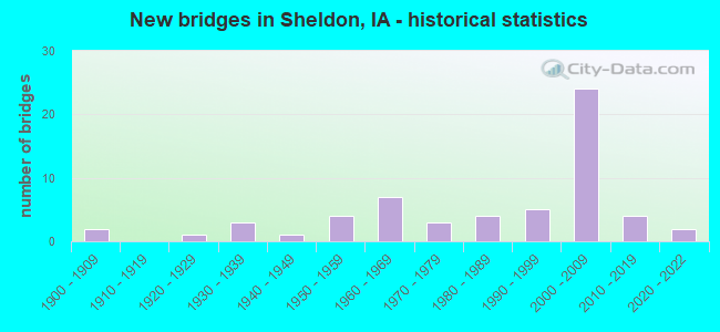
- New bridges - historical statistics
- 21900-1909
- 11920-1929
- 31930-1939
- 11940-1949
- 41950-1959
- 71960-1969
- 31970-1979
- 41980-1989
- 51990-1999
- 242000-2009
- 42010-2019
- 22020-2022
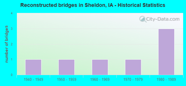
- Reconstructed bridges - Historical Statistics
- 11940-1949
- 11950-1959
- 11960-1969
- 11970-1979
- 31980-1989
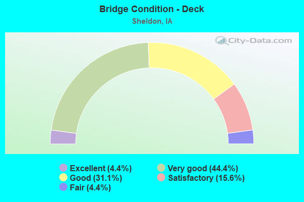
- Bridge Condition - Deck
- 4.4%Excellent
- 44.4%Very good
- 31.1%Good
- 15.6%Satisfactory
- 4.4%Fair
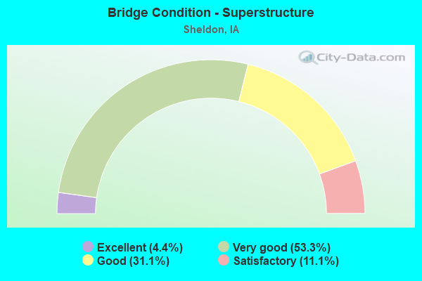
- Bridge Condition - Superstructure
- 4.4%Excellent
- 53.3%Very good
- 31.1%Good
- 11.1%Satisfactory
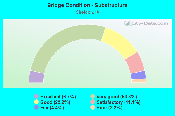
- Bridge Condition - Substructure
- 6.7%Excellent
- 53.3%Very good
- 22.2%Good
- 11.1%Satisfactory
- 4.4%Fair
- 2.2%Poor
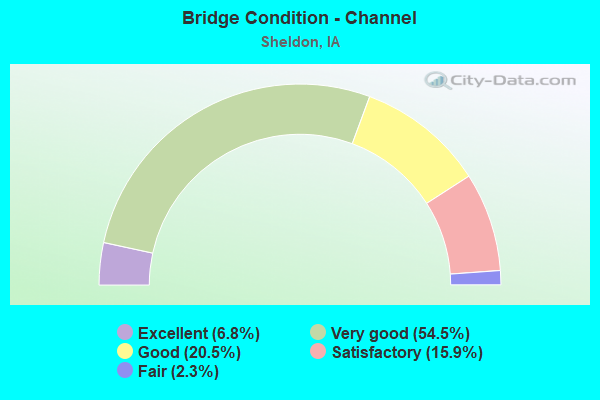
- Bridge Condition - Channel
- 6.8%Excellent
- 54.5%Very good
- 20.5%Good
- 15.9%Satisfactory
- 2.3%Fair
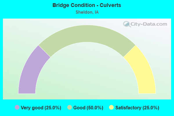
- Bridge Condition - Culverts
- 25.0%Very good
- 50.0%Good
- 25.0%Satisfactory
Find on map >> Show street view
Structure Number: 6089, Location: At Jct. U.S. 18 (Lat: 43.185603, Lng: -95.812761), Route carried "on" structure: State highway 60, Year Built: 2004, Status: Open, Structure Length: 7.68m (25.20ft), Average Daily Traffic: 1,575 (year 2020), Truck Traffic: 42%, Average Future Daily Traffic: 1,575 (year 2041), Design Load: HS 20, Features Intersected: U.S. 18
Minimum Vertical Clearance: 30+ m (98+ ft), Kilometerpoint: 55.886, Lanes on structure: 2, Lanes under structure: 2, Base Highway Network: Yes, Owner: State Highway Agency, Approaching Roadway Width: 12.2m (40.0ft), Material/Design: Prestressed concrete, Design/Construction: Stringer/Multi-beam, Number Of Spans In Main Unit: 3, Length of Maximum Span: 41.8m (137.1ft), Curb-To-Curb Width: 12.2m (40.0ft), Out-to-Out Width: 13.2m (43.3ft)
Condition: Deck: Very good, Superstructure: Very good, Substructure: Very good, Operating Rating: 88.8 metric tons, Method Used To Determine Operating Rating: Load Factor (LF), Inventory Rating: 45.4 metric tons, Method Used To Determine Inventory Rating: Load Factor (LF), Structural Evaluation: Equal to present desirable criteria, Deck Geometry: Better than present minimum criteria, Underclear: Superior to present desirable criteria, Approach Roadway Alignment: Equal to present desirable criteria, Designated Inspection Frequency: Every 24 months, Inspection Date: March 2021, Deck Structure Type: Concrete Cast-file-Place, Wearing Surface/Protective System: Wearing Surface: Monolithic Concrete, Deck Protection: Epoxy Coated Reinforcing
Find on map >> Show street view
Structure Number: 60891, Location: 1.6 mi. S of jct. US 18 (Lat: 43.164833, Lng: -95.821983), Route carried "on" structure: County highway , Year Built: 2004, Status: Open, Structure Length: 8.69m (28.51ft), Average Daily Traffic: 260 (year 2019), Truck Traffic: 5%, Average Future Daily Traffic: 260 (year 2042), Design Load: HS 20, Features Intersected: IA 60, Facility Carried by Structure: NEST AVENUE
Minimum Vertical Clearance: 30+ m (98+ ft), Kilometerpoint: 28.378, Lanes on structure: 2, Lanes under structure: 4, Owner: State Highway Agency, Approaching Roadway Width: 13.4m (44.0ft), Skew: 2 degrees, Material/Design: Prestressed concrete, Design/Construction: Stringer/Multi-beam, Number Of Spans In Main Unit: 2, Length of Maximum Span: 43.0m (141.1ft), Curb-To-Curb Width: 13.4m (44.0ft), Out-to-Out Width: 14.6m (47.9ft)
Condition: Deck: Very good, Superstructure: Very good, Substructure: Good, Operating Rating: 82.8 metric tons, Method Used To Determine Operating Rating: Load Factor (LF), Inventory Rating: 36.4 metric tons, Method Used To Determine Inventory Rating: Load Factor (LF), Structural Evaluation: Better than present minimum criteria, Deck Geometry: Superior to present desirable criteria, Underclear: Somewhat better than minimum adequacy, Approach Roadway Alignment: Equal to present desirable criteria, Designated Inspection Frequency: Every 24 months, Inspection Date: January 2022, Deck Structure Type: Concrete Cast-file-Place, Wearing Surface/Protective System: Wearing Surface: Monolithic Concrete, Deck Protection: Epoxy Coated Reinforcing
Find on map >> Show street view
Structure Number: 608915, Location: 1.0 mi. S of jct. US 18 (Lat: 43.171444, Lng: -95.814500), Route carried "on" structure: County highway , Year Built: 2005, Status: Open, Structure Length: 8.38m (27.49ft), Average Daily Traffic: 620 (year 2019), Truck Traffic: 16%, Average Future Daily Traffic: 620 (year 2042), Design Load: HS 20, Features Intersected: IA 60, Facility Carried by Structure: 330TH STREET
Minimum Vertical Clearance: 30+ m (98+ ft), Kilometerpoint: 1.413, Lanes on structure: 2, Lanes under structure: 4, Owner: State Highway Agency, Approaching Roadway Width: 11.6m (38.1ft), Skew: 2 degrees, Material/Design: Prestressed concrete, Design/Construction: Stringer/Multi-beam, Number Of Spans In Main Unit: 2, Length of Maximum Span: 41.1m (134.8ft), Curb-To-Curb Width: 11.6m (38.1ft), Out-to-Out Width: 12.7m (41.7ft)
Condition: Deck: Very good, Superstructure: Good, Substructure: Very good, Operating Rating: 79.8 metric tons, Method Used To Determine Operating Rating: Load Factor (LF), Inventory Rating: 36.7 metric tons, Method Used To Determine Inventory Rating: Load Factor (LF), Structural Evaluation: Better than present minimum criteria, Deck Geometry: Better than present minimum criteria, Underclear: Equal to present minimum criteria, Approach Roadway Alignment: Equal to present desirable criteria, Designated Inspection Frequency: Every 24 months, Inspection Date: January 2022, Deck Structure Type: Concrete Cast-file-Place, Wearing Surface/Protective System: Wearing Surface: Monolithic Concrete, Deck Protection: Epoxy Coated Reinforcing
Find on map >> Show street view
Structure Number: 60892, Location: 0.6 mi S of jct US 18 (Lat: 43.178519, Lng: -95.813000), Route carried "on" structure: State highway 60, Year Built: 2005, Status: Open, Structure Length: 8.87m (29.10ft), Average Daily Traffic: 2,345 (year 2020), Truck Traffic: 35%, Average Future Daily Traffic: 2,345 (year 2042), Design Load: HS 20, Features Intersected: DME RR
Minimum Vertical Clearance: 30+ m (98+ ft), Kilometerpoint: 40.003, Lanes on structure: 2, Owner: State Highway Agency, Approaching Roadway Width: 12.2m (40.0ft), Material/Design: Prestressed concrete, Design/Construction: Stringer/Multi-beam, Number Of Spans In Main Unit: 3, Length of Maximum Span: 32.3m (106.0ft), Curb-To-Curb Width: 12.2m (40.0ft), Out-to-Out Width: 13.2m (43.3ft)
Condition: Deck: Very good, Superstructure: Very good, Substructure: Very good, Operating Rating: 71.4 metric tons, Method Used To Determine Operating Rating: Load Factor (LF), Inventory Rating: 37.9 metric tons, Method Used To Determine Inventory Rating: Load Factor (LF), Structural Evaluation: Equal to present desirable criteria, Deck Geometry: Better than present minimum criteria, Underclear: Superior to present desirable criteria, Approach Roadway Alignment: Equal to present desirable criteria, Designated Inspection Frequency: Every 24 months, Inspection Date: January 2022, Deck Structure Type: Concrete Cast-file-Place, Wearing Surface/Protective System: Wearing Surface: Monolithic Concrete, Deck Protection: Epoxy Coated Reinforcing
Find on map >> Show street view
Structure Number: 608925, Location: 0.6 mi. S of jct. US 18 (Lat: 43.177725, Lng: -95.812639), Route carried "on" structure: State highway 60, Year Built: 2005, Status: Open, Structure Length: 8.87m (29.10ft), Average Daily Traffic: 2,345 (year 2020), Truck Traffic: 35%, Average Future Daily Traffic: 2,345 (year 2042), Design Load: HS 20, Features Intersected: DME RR
Minimum Vertical Clearance: 30+ m (98+ ft), Kilometerpoint: 55.011, Lanes on structure: 2, Base Highway Network: Yes, Owner: State Highway Agency, Approaching Roadway Width: 12.2m (40.0ft), Material/Design: Prestressed concrete, Design/Construction: Stringer/Multi-beam, Number Of Spans In Main Unit: 3, Length of Maximum Span: 32.3m (106.0ft), Curb-To-Curb Width: 12.2m (40.0ft), Out-to-Out Width: 13.2m (43.3ft)
Condition: Deck: Very good, Superstructure: Very good, Substructure: Very good, Operating Rating: 71.4 metric tons, Method Used To Determine Operating Rating: Load Factor (LF), Inventory Rating: 37.9 metric tons, Method Used To Determine Inventory Rating: Load Factor (LF), Structural Evaluation: Equal to present desirable criteria, Deck Geometry: Better than present minimum criteria, Underclear: Superior to present desirable criteria, Approach Roadway Alignment: Equal to present desirable criteria, Designated Inspection Frequency: Every 24 months, Inspection Date: January 2022, Deck Structure Type: Concrete Cast-file-Place, Wearing Surface/Protective System: Wearing Surface: Monolithic Concrete, Deck Protection: Epoxy Coated Reinforcing
Find on map >> Show street view
Structure Number: 608945, Location: 1.5 mi. N of US 18 (Lat: 43.208258, Lng: -95.812650), Route carried "on" structure: State highway 60, Year Built: 2006, Status: Open, Structure Length: 1.31m (4.30ft), Average Daily Traffic: 4,720 (year 2020), Truck Traffic: 30%, Average Future Daily Traffic: 4,720 (year 2042), Design Load: HS 20, Features Intersected: ENGELS CREEK
Minimum Vertical Clearance: 30+ m (98+ ft), Kilometerpoint: 58.403, Lanes on structure: 4, Base Highway Network: Yes, Owner: State Highway Agency, Approaching Roadway Width: 26.8m (87.9ft), Skew: 3 degrees, Material/Design: Concrete continuous, Design/Construction: Culvert, Number Of Spans In Main Unit: 3, Length of Maximum Span: 3.7m (12.1ft)
Condition: Channel: Very good, Culverts: Good, Operating Rating: 29.5 metric tons, Method Used To Determine Operating Rating: Load and Resistance Factor Rating (LRFR) rating reported by rating factor(RF) method using HL-93 loadings, Inventory Rating: 22.7 metric tons, Method Used To Determine Inventory Rating: Load and Resistance Factor Rating (LRFR) rating reported by rating factor(RF) method using HL-93 loadings, Structural Evaluation: Equal to present minimum criteria, Waterway Adequacy: Equal to present desirable criteria, Approach Roadway Alignment: Equal to present desirable criteria, Designated Inspection Frequency: Every 24 months, Inspection Date: January 2022
Find on map >> Show street view
Structure Number: 609235, Location: 0.4 mi. S of Jct. SR L26 (Lat: 43.156383, Lng: -95.867472), Route carried "on" structure: State highway 60, Year Built: 2005, Status: Open, Structure Length: 6.95m (22.80ft), Average Daily Traffic: 2,900 (year 2020), Truck Traffic: 28%, Average Future Daily Traffic: 2,900 (year 2042), Design Load: HS 20, Features Intersected: LITTLE FLOYD RIVER
Minimum Vertical Clearance: 30+ m (98+ ft), Kilometerpoint: 49.334, Lanes on structure: 2, Base Highway Network: Yes, Owner: State Highway Agency, Approaching Roadway Width: 11.9m (39.0ft), Skew: 1 degrees, Material/Design: Prestressed concrete, Design/Construction: Stringer/Multi-beam, Number Of Spans In Main Unit: 3, Length of Maximum Span: 25.0m (82.0ft), Curb-To-Curb Width: 12.0m (39.4ft), Out-to-Out Width: 13.0m (42.7ft)
Condition: Deck: Good, Superstructure: Very good, Substructure: Very good, Channel: Very good, Operating Rating: 76.2 metric tons, Method Used To Determine Operating Rating: Load Factor (LF), Inventory Rating: 35.1 metric tons, Method Used To Determine Inventory Rating: Load Factor (LF), Structural Evaluation: Equal to present desirable criteria, Deck Geometry: Better than present minimum criteria, Waterway Adequacy: Equal to present desirable criteria, Approach Roadway Alignment: Equal to present desirable criteria, Designated Inspection Frequency: Every 24 months, Inspection Date: January 2022, Deck Structure Type: Concrete Cast-file-Place, Wearing Surface/Protective System: Wearing Surface: Monolithic Concrete, Deck Protection: Epoxy Coated Reinforcing
Find on map >> Show street view
Structure Number: 60924, Location: 0.4 mi. S of SR L26 (Lat: 43.156953, Lng: -95.867239), Route carried "on" structure: State highway 60, Year Built: 2006, Status: Open, Structure Length: 6.95m (22.80ft), Average Daily Traffic: 2,900 (year 2020), Truck Traffic: 28%, Average Future Daily Traffic: 2,900 (year 2042), Design Load: HS 20, Features Intersected: LITTLE FLOYD RIVER
Minimum Vertical Clearance: 30+ m (98+ ft), Kilometerpoint: 45.686, Lanes on structure: 2, Owner: State Highway Agency, Approaching Roadway Width: 14.0m (45.9ft), Skew: 1 degrees, Material/Design: Prestressed concrete, Design/Construction: Stringer/Multi-beam, Number Of Spans In Main Unit: 3, Length of Maximum Span: 25.0m (82.0ft), Curb-To-Curb Width: 14.0m (45.9ft), Out-to-Out Width: 15.1m (49.5ft)
Condition: Deck: Good, Superstructure: Very good, Substructure: Good, Channel: Good, Operating Rating: 76.2 metric tons, Method Used To Determine Operating Rating: Load Factor (LF), Inventory Rating: 35.1 metric tons, Method Used To Determine Inventory Rating: Load Factor (LF), Structural Evaluation: Better than present minimum criteria, Deck Geometry: Superior to present desirable criteria, Waterway Adequacy: Equal to present desirable criteria, Approach Roadway Alignment: Equal to present desirable criteria, Designated Inspection Frequency: Every 24 months, Inspection Date: January 2022, Deck Structure Type: Concrete Cast-file-Place, Wearing Surface/Protective System: Wearing Surface: Monolithic Concrete, Deck Protection: Epoxy Coated Reinforcing
Find on map >> Show street view
Structure Number: 609245, Location: 3.8 mi. S of Jct. U.S. 18 (Lat: 43.160425, Lng: -95.861597), Route carried "on" structure: State highway 60, Year Built: 2004, Status: Open, Structure Length: 6.80m (22.31ft), Average Daily Traffic: 2,270 (year 2020), Truck Traffic: 34%, Average Future Daily Traffic: 2,270 (year 2041), Design Load: HS 20, Features Intersected: MCKINLEY AVE
Minimum Vertical Clearance: 30+ m (98+ ft), Kilometerpoint: 49.991, Lanes on structure: 2, Lanes under structure: 2, Base Highway Network: Yes, Owner: State Highway Agency, Approaching Roadway Width: 12.8m (42.0ft), Skew: 3 degrees, Material/Design: Prestressed concrete, Design/Construction: Stringer/Multi-beam, Number Of Spans In Main Unit: 3, Length of Maximum Span: 32.6m (107.0ft), Curb-To-Curb Width: 11.9m (39.0ft), Out-to-Out Width: 13.2m (43.3ft)
Condition: Deck: Good, Superstructure: Very good, Substructure: Very good, Operating Rating: 72.8 metric tons, Method Used To Determine Operating Rating: Load Factor (LF), Inventory Rating: 36.3 metric tons, Method Used To Determine Inventory Rating: Load Factor (LF), Structural Evaluation: Equal to present desirable criteria, Deck Geometry: Better than present minimum criteria, Underclear: Superior to present desirable criteria, Approach Roadway Alignment: Equal to present desirable criteria, Designated Inspection Frequency: Every 24 months, Inspection Date: October 2021, Deck Structure Type: Concrete Cast-file-Place, Wearing Surface/Protective System: Wearing Surface: Monolithic Concrete, Deck Protection: Epoxy Coated Reinforcing
Find on map >> Show street view
Structure Number: 60925, Location: 3.8 mi. S of Jct. U.S. 18 (Lat: 43.161069, Lng: -95.860953), Route carried "on" structure: State highway 60, Year Built: 2004, Status: Open, Structure Length: 6.80m (22.31ft), Average Daily Traffic: 2,270 (year 2020), Truck Traffic: 34%, Average Future Daily Traffic: 2,270 (year 2041), Design Load: HS 20, Features Intersected: MCKINLEY AVE
Minimum Vertical Clearance: 30+ m (98+ ft), Kilometerpoint: 44.999, Lanes on structure: 2, Lanes under structure: 2, Owner: State Highway Agency, Approaching Roadway Width: 12.8m (42.0ft), Skew: 3 degrees, Material/Design: Prestressed concrete, Design/Construction: Stringer/Multi-beam, Number Of Spans In Main Unit: 3, Length of Maximum Span: 32.6m (107.0ft), Curb-To-Curb Width: 11.9m (39.0ft), Out-to-Out Width: 13.2m (43.3ft)
Condition: Deck: Very good, Superstructure: Very good, Substructure: Very good, Operating Rating: 72.8 metric tons, Method Used To Determine Operating Rating: Load Factor (LF), Inventory Rating: 36.3 metric tons, Method Used To Determine Inventory Rating: Load Factor (LF), Structural Evaluation: Equal to present desirable criteria, Deck Geometry: Better than present minimum criteria, Underclear: Superior to present desirable criteria, Approach Roadway Alignment: Equal to present desirable criteria, Designated Inspection Frequency: Every 24 months, Inspection Date: October 2021, Deck Structure Type: Concrete Cast-file-Place, Wearing Surface/Protective System: Wearing Surface: Monolithic Concrete, Deck Protection: Epoxy Coated Reinforcing
Find on map >> Show street view
Structure Number: 609555, Location: 2.6 mi. S of jct. US 18 (Lat: 43.163603, Lng: -95.841781), Route carried "on" structure: County highway , Year Built: 2005, Status: Open, Structure Length: 7.16m (23.49ft), Average Daily Traffic: 100 (year 2019), Truck Traffic: 25%, Average Future Daily Traffic: 100 (year 2042), Design Load: HS 20, Features Intersected: IA 60, Facility Carried by Structure: MONROE AVE
Minimum Vertical Clearance: 30+ m (98+ ft), Kilometerpoint: 28.252, Lanes on structure: 2, Lanes under structure: 4, Owner: State Highway Agency, Approaching Roadway Width: 9.1m (29.9ft), Material/Design: Prestressed concrete, Design/Construction: Stringer/Multi-beam, Number Of Spans In Main Unit: 2, Length of Maximum Span: 35.4m (116.1ft), Curb-To-Curb Width: 9.1m (29.9ft), Out-to-Out Width: 10.2m (33.5ft)
Condition: Deck: Very good, Superstructure: Good, Substructure: Very good, Operating Rating: 90.5 metric tons, Method Used To Determine Operating Rating: Load Factor (LF), Inventory Rating: 40.8 metric tons, Method Used To Determine Inventory Rating: Load Factor (LF), Structural Evaluation: Better than present minimum criteria, Deck Geometry: Better than present minimum criteria, Underclear: Somewhat better than minimum adequacy, Approach Roadway Alignment: Equal to present desirable criteria, Designated Inspection Frequency: Every 24 months, Inspection Date: January 2022, Deck Structure Type: Concrete Cast-file-Place, Wearing Surface/Protective System: Wearing Surface: Monolithic Concrete, Deck Protection: Epoxy Coated Reinforcing
Find on map >> Show street view
Structure Number: 608895, Location: At Jct. U.S. 18 (Lat: 43.186292, Lng: -95.813139), Route carried "under" structure: US 18, Year Built: 2004, Structure Length: 0. m, Average Daily Traffic: 2,850 (year 2020), Truck Traffic: 12%, Features Intersected: US 18, Facility Carried by Structure: IA 60 SB
Minimum Vertical Clearance: 30+ m (98+ ft), Kilometerpoint: 71.223, Lanes on structure: 2, Lanes under structure: 2, Material/Design: Prestressed concrete, Design/Construction: Stringer/Multi-beam, Length of Maximum Span: 41.8m (137.1ft)
Find on map >> Show street view
Structure Number: 6089, Location: At Jct. U.S. 18 (Lat: 43.185603, Lng: -95.812761), Route carried "under" structure: US 18, Year Built: 2004, Structure Length: 0. m, Average Daily Traffic: 2,850 (year 2020), Truck Traffic: 12%, Features Intersected: U.S. 18, Facility Carried by Structure: IA 60 NB
Minimum Vertical Clearance: 30+ m (98+ ft), Kilometerpoint: 71.254, Lanes on structure: 2, Lanes under structure: 2, Material/Design: Prestressed concrete, Design/Construction: Stringer/Multi-beam, Length of Maximum Span: 41.8m (137.1ft)
Find on map >> Show street view
Structure Number: 60891, Location: 1.6 mi. S of jct. US 18 (Lat: 43.164833, Lng: -95.821983), Route carried "under" structure: State highway 60, Year Built: 2004, Structure Length: 0. m, Average Daily Traffic: 4,630 (year 2020), Truck Traffic: 35%, Features Intersected: IA 60, Facility Carried by Structure: NEST AVENUE
Minimum Vertical Clearance: 30+ m (98+ ft), Kilometerpoint: 53.301, Lanes on structure: 2, Lanes under structure: 4, Material/Design: Prestressed concrete, Design/Construction: Stringer/Multi-beam, Length of Maximum Span: 43.0m (141.1ft)
Find on map >> Show street view
Structure Number: 608915, Location: 1.0 mi. S of jct. US 18 (Lat: 43.171444, Lng: -95.814500), Route carried "under" structure: State highway 60, Year Built: 2005, Structure Length: 0. m, Average Daily Traffic: 4,720 (year 2020), Truck Traffic: 34%, Features Intersected: IA 60, Facility Carried by Structure: 330TH STREET
Minimum Vertical Clearance: 30+ m (98+ ft), Kilometerpoint: 54.296, Lanes on structure: 2, Lanes under structure: 4, Material/Design: Prestressed concrete, Design/Construction: Stringer/Multi-beam, Length of Maximum Span: 41.1m (134.8ft)
Find on map >> Show street view
Structure Number: 609245, Location: 3.8 mi. S of Jct. U.S. 18 (Lat: 43.160425, Lng: -95.861597), Route carried "under" structure: County highway , Year Built: 2004, Structure Length: 0. m, Average Daily Traffic: 800 (year 2019), Truck Traffic: 15%, Features Intersected: MCKINLEY AVE, Facility Carried by Structure: IA 60 NB
Minimum Vertical Clearance: 30+ m (98+ ft), Kilometerpoint: 27.930, Lanes on structure: 2, Lanes under structure: 2, Material/Design: Prestressed concrete, Design/Construction: Stringer/Multi-beam, Length of Maximum Span: 32.6m (107.0ft)
Find on map >> Show street view
Structure Number: 60925, Location: 3.8 mi. S of Jct. U.S. 18 (Lat: 43.161069, Lng: -95.860953), Route carried "under" structure: County highway , Year Built: 2004, Structure Length: 0. m, Average Daily Traffic: 800 (year 2019), Truck Traffic: 15%, Features Intersected: MCKINLEY AVE, Facility Carried by Structure: IA 60 SB
Minimum Vertical Clearance: 30+ m (98+ ft), Kilometerpoint: 27.966, Lanes on structure: 2, Lanes under structure: 2, Material/Design: Prestressed concrete, Design/Construction: Stringer/Multi-beam, Length of Maximum Span: 32.6m (107.0ft)
Find on map >> Show street view
Structure Number: 609555, Location: 2.6 mi. S of jct. US 18 (Lat: 43.163603, Lng: -95.841781), Route carried "under" structure: State highway 60, Year Built: 2005, Structure Length: 0. m, Average Daily Traffic: 4,900 (year 2020), Truck Traffic: 33%, Features Intersected: IA 60, Facility Carried by Structure: MONROE AVE
Minimum Vertical Clearance: 30+ m (98+ ft), Kilometerpoint: 51.671, Lanes on structure: 2, Lanes under structure: 4, Material/Design: Prestressed concrete, Design/Construction: Stringer/Multi-beam, Length of Maximum Span: 35.4m (116.1ft)