Bridge Statistics for Silverthorne, Colorado (CO)
Condition, Traffic, Stress, Structural Evaluation, Project Costs
- National Bridge Inventory (NBI) Statistics
- 15Number of bridges
- 220ft / 67.4mTotal length
- $5,000Total costs
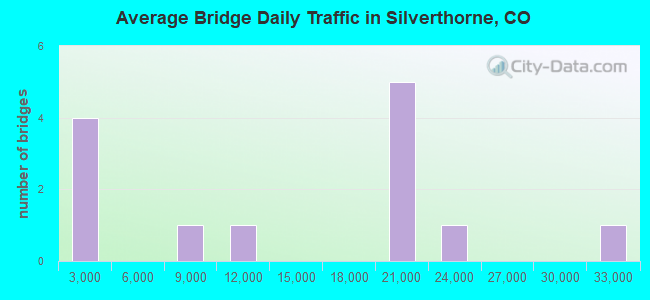
- 179,634Total average daily traffic
- 13,683Total average daily truck traffic
- National Bridge Inventory (NBI) Registered Bridges for Silverthorne
- No street view available for this location
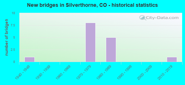
- New bridges - historical statistics
- 11940-1949
- 81970-1979
- 51980-1989
- 12010-2019
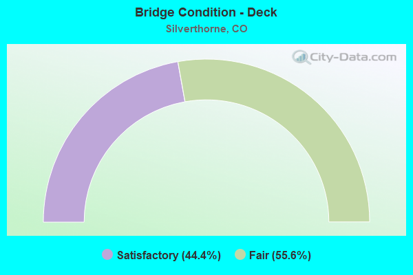
- Bridge Condition - Deck
- 44.4%Satisfactory
- 55.6%Fair
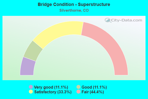
- Bridge Condition - Superstructure
- 11.1%Very good
- 11.1%Good
- 33.3%Satisfactory
- 44.4%Fair
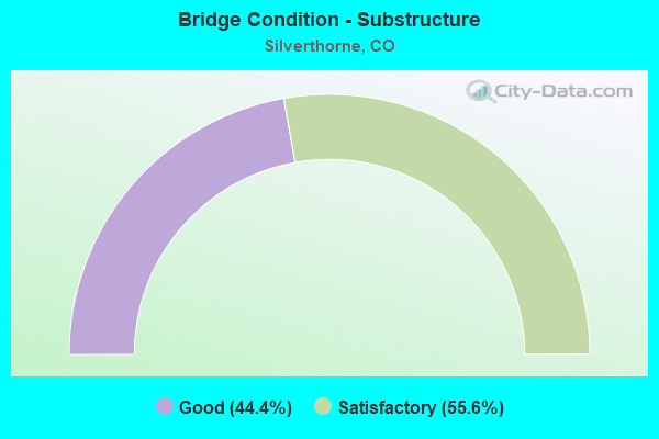
- Bridge Condition - Substructure
- 44.4%Good
- 55.6%Satisfactory
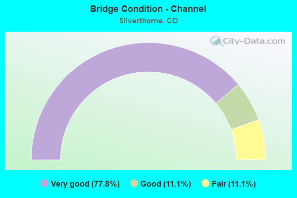
- Bridge Condition - Channel
- 77.8%Very good
- 11.1%Good
- 11.1%Fair
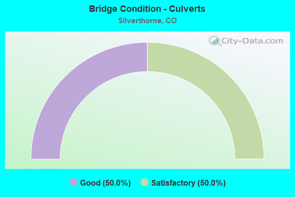
- Bridge Condition - Culverts
- 50.0%Good
- 50.0%Satisfactory
Find on map >> Show street view
Structure Number: 117137500.10006, Location: .1 MI W OF STATE HWY 9 (Lat: 39.737228, Lng: -106.135622), Route carried "on" structure: County highway , Year Built: 1945, Status: Open, Structure Length: 1.33m (4.36ft), Average Daily Traffic: 43 (year 2020), Average Future Daily Traffic: 53 (year 2040), Features Intersected: BOULDER CREEK, Facility Carried by Structure: BOULDER CREEK RD
Minimum Vertical Clearance: 30+ m (98+ ft), Kilometerpoint: 3.384, Lanes on structure: 2, Owner: County Highway Agency, Approaching Roadway Width: 6.7m (22.0ft), Material/Design: Concrete, Design/Construction: Stringer/Multi-beam, Number Of Spans In Main Unit: 1, Length of Maximum Span: 12.3m (40.4ft), Curb-To-Curb Width: 6.1m (20.0ft), Out-to-Out Width: 6.6m (21.7ft)
Condition: Deck: Satisfactory, Superstructure: Fair, Substructure: Satisfactory, Channel: Very good, Operating Rating: 36.3 metric tons, Method Used To Determine Operating Rating: Field evaluation and documented engineering judgment, Inventory Rating: 32.7 metric tons, Method Used To Determine Inventory Rating: Field evaluation and documented engineering judgment, Structural Evaluation: Somewhat better than minimum adequacy, Deck Geometry: Somewhat better than minimum adequacy, Waterway Adequacy: Equal to present desirable criteria, Approach Roadway Alignment: Equal to present desirable criteria, Designated Inspection Frequency: Every 24 months, Inspection Date: June 2021, Deck Structure Type: Concrete Cast-file-Place, Wearing Surface/Protective System: Wearing Surface: Monolithic Concrete
Find on map >> Show street view
Structure Number: 117190000.4001A, Location: .4 MILE EAST OF HIGHWAY 9 (Lat: 39.662114, Lng: -106.080186), Route carried "on" structure: County highway , Year Built: 1980, Status: Open, Structure Length: 1.95m (6.40ft), Average Daily Traffic: 483 (year 2020), Truck Traffic: 4%, Average Future Daily Traffic: 589 (year 2040), Features Intersected: BLUE RIVER, Facility Carried by Structure: HAMILTON CREEK RD
Minimum Vertical Clearance: 30+ m (98+ ft), Kilometerpoint: 0.275, Lanes on structure: 2, Owner: County Highway Agency, Approaching Roadway Width: 7.6m (24.9ft), Material/Design: Prestressed concrete, Design/Construction: Tee Beam, Number Of Spans In Main Unit: 1, Length of Maximum Span: 18.9m (62.0ft), Curb or Sidewalk Widths: Left: 0.3m (1.0ft), Right: 0.3m (1.0ft), Curb-To-Curb Width: 7.4m (24.3ft), Out-to-Out Width: 8.0m (26.2ft)
Condition: Deck: Fair, Superstructure: Satisfactory, Substructure: Good, Channel: Fair, Operating Rating: 37.6 metric tons, Method Used To Determine Operating Rating: Load Factor (LF), Inventory Rating: 22.5 metric tons, Method Used To Determine Inventory Rating: Load Factor (LF), Structural Evaluation: Equal to present minimum criteria, Deck Geometry: Meets minimum limits, Waterway Adequacy: Equal to present desirable criteria, Approach Roadway Alignment: Better than present minimum criteria, Designated Inspection Frequency: Every 24 months, Inspection Date: June 2021, Deck Structure Type: Concrete Cast-file-Place, Wearing Surface/Protective System: Wearing Surface: Monolithic Concrete
Find on map >> Show street view
Structure Number: F-12-BP, Location: IN SILVERTHORNE (Lat: 39.629364, Lng: -106.071464), Route carried "on" structure: State highway 9D, Year Built: 1982, Status: Open, Structure Length: 2.10m (6.89ft), Average Daily Traffic: 20,000 (year 2020), Truck Traffic: 6%, Average Future Daily Traffic: 24,800 (year 2040), Design Load: HS 20, Features Intersected: BLUE RIVER, Facility Carried by Structure: SH 9 ML
Minimum Vertical Clearance: 30+ m (98+ ft), Kilometerpoint: 0.380, Lanes on structure: 5, Owner: State Highway Agency, Approaching Roadway Width: 21.0m (68.9ft), Skew: 20 degrees, Material/Design: Concrete, Design/Construction: Culvert, Number Of Spans In Main Unit: 5, Length of Maximum Span: 4.3m (14.1ft), Curb or Sidewalk Widths: Left: 3.5m (11.5ft), Right: 3.5m (11.5ft), Curb-To-Curb Width: 21.8m (71.5ft), Out-to-Out Width: 42.1m (138.1ft)
Condition: Channel: Very good, Culverts: Satisfactory, Structural Evaluation: Equal to present minimum criteria, Deck Geometry: Somewhat better than minimum adequacy, Waterway Adequacy: Superior to present desirable criteria, Approach Roadway Alignment: Equal to present desirable criteria, Designated Inspection Frequency: Every 24 months, Inspection Date: August 2021
Find on map >> Show street view
Structure Number: F-12-R, Location: AT SILVERTHORNE (Lat: 39.628458, Lng: -106.067919), Route carried "on" structure: Interstate 70A, Year Built: 1971, Status: Open, Structure Length: 9.51m (31.20ft), Average Daily Traffic: 20,000 (year 2020), Truck Traffic: 10%, Average Future Daily Traffic: 24,600 (year 2040), Design Load: HS 25 or greater, Features Intersected: US 6 ML, Facility Carried by Structure: I70 ML WBND
Minimum Vertical Clearance: 30+ m (98+ ft), Kilometerpoint: 332.275, Lanes on structure: 2, Lanes under structure: 6, Base Highway Network: Yes, Owner: State Highway Agency, Approaching Roadway Width: 11.6m (38.1ft), Skew: 15 degrees, Material/Design: Steel continuous, Design/Construction: Stringer/Multi-beam, Number Of Spans In Main Unit: 4, Length of Maximum Span: 26.0m (85.3ft), Curb-To-Curb Width: 12.8m (42.0ft), Out-to-Out Width: 13.6m (44.6ft)
Condition: Deck: Fair, Superstructure: Satisfactory, Substructure: Satisfactory, Operating Rating: 51.3 metric tons, Method Used To Determine Operating Rating: Load Factor (LF), Inventory Rating: 30.8 metric tons, Method Used To Determine Inventory Rating: Load Factor (LF), Structural Evaluation: Equal to present minimum criteria, Deck Geometry: Equal to present desirable criteria, Underclear: High priority of corrective action, Approach Roadway Alignment: Equal to present desirable criteria, Designated Inspection Frequency: Every 24 months, Inspection Date: May 2021, Deck Structure Type: Concrete Cast-file-Place, Wearing Surface/Protective System: Wearing Surface: Bituminous, Membrane: Built-up
Find on map >> Show street view
Structure Number: F-12-S, Location: AT SILVERTHORNE (Lat: 39.628411, Lng: -106.067419), Route carried "on" structure: Interstate 70A, Year Built: 1971, Status: Open, Structure Length: 9.05m (29.69ft), Average Daily Traffic: 20,000 (year 2020), Truck Traffic: 10%, Average Future Daily Traffic: 24,600 (year 2040), Design Load: HS 20+Mod, Features Intersected: US 6 ML, Facility Carried by Structure: I 70 ML EBND
Minimum Vertical Clearance: 30+ m (98+ ft), Kilometerpoint: 332.309, Lanes on structure: 2, Lanes under structure: 6, Base Highway Network: Yes, Owner: State Highway Agency, Approaching Roadway Width: 11.6m (38.1ft), Skew: 15 degrees, Material/Design: Steel continuous, Design/Construction: Stringer/Multi-beam, Number Of Spans In Main Unit: 4, Length of Maximum Span: 26.0m (85.3ft), Curb-To-Curb Width: 12.8m (42.0ft), Out-to-Out Width: 13.5m (44.3ft)
Condition: Deck: Satisfactory, Superstructure: Satisfactory, Substructure: Satisfactory, Operating Rating: 51.3 metric tons, Method Used To Determine Operating Rating: Load Factor (LF), Inventory Rating: 30.7 metric tons, Method Used To Determine Inventory Rating: Load Factor (LF), Structural Evaluation: Equal to present minimum criteria, Deck Geometry: Equal to present desirable criteria, Underclear: High priority of corrective action, Approach Roadway Alignment: Equal to present desirable criteria, Designated Inspection Frequency: Every 24 months, Inspection Date: May 2021, Deck Structure Type: Concrete Cast-file-Place, Wearing Surface/Protective System: Wearing Surface: Bituminous, Membrane: Built-up
Find on map >> Show street view
Structure Number: F-12-X, Location: IN SILVERTHORNE (Lat: 39.625933, Lng: -106.071689), Route carried "on" structure: Interstate 70A, Year Built: 1971, Status: Open, Structure Length: 16.89m (55.41ft), Average Daily Traffic: 20,000 (year 2020), Truck Traffic: 10%, Average Future Daily Traffic: 24,600 (year 2040), Design Load: HS 20, Features Intersected: BlueRvr-Adams Ave and..., Facility Carried by Structure: I 70 ML WBND
Minimum Vertical Clearance: 30+ m (98+ ft), Kilometerpoint: 331.850, Lanes on structure: 3, Lanes under structure: 4, Base Highway Network: Yes, Owner: State Highway Agency, Approaching Roadway Width: 18.9m (62.0ft), Skew: 10 degrees, Material/Design: Steel continuous, Design/Construction: Stringer/Multi-beam, Number Of Spans In Main Unit: 4, Length of Maximum Span: 50.0m (164.0ft), Curb-To-Curb Width: 14.6m (47.9ft), Out-to-Out Width: 15.4m (50.5ft)
Condition: Deck: Fair, Superstructure: Fair, Substructure: Good, Channel: Very good, Operating Rating: 48.3 metric tons, Method Used To Determine Operating Rating: Load Factor (LF), Inventory Rating: 28.9 metric tons, Method Used To Determine Inventory Rating: Load Factor (LF), Structural Evaluation: Somewhat better than minimum adequacy, Deck Geometry: Meets minimum limits, Underclear: Meets minimum limits, Waterway Adequacy: Equal to present desirable criteria, Approach Roadway Alignment: Equal to present desirable criteria, Designated Inspection Frequency: Every 24 months, Inspection Date: September 2021, Deck Structure Type: Concrete Cast-file-Place, Wearing Surface/Protective System: Wearing Surface: Bituminous
Find on map >> Show street view
Structure Number: F-12-Y, Location: 10.5 MI E OF JCT SH 91 (Lat: 39.625717, Lng: -106.071358), Route carried "on" structure: Interstate 70A, Year Built: 1971, Status: Open, Structure Length: 16.89m (55.41ft), Average Daily Traffic: 20,000 (year 2020), Truck Traffic: 10%, Average Future Daily Traffic: 24,600 (year 2040), Design Load: HS 20+Mod, Features Intersected: BlueRvr-Adams Ave and..., Facility Carried by Structure: I 70 ML EBND
Minimum Vertical Clearance: 30+ m (98+ ft), Kilometerpoint: 331.848, Lanes on structure: 2, Lanes under structure: 5, Base Highway Network: Yes, Owner: State Highway Agency, Approaching Roadway Width: 11.6m (38.1ft), Skew: 10 degrees, Material/Design: Steel continuous, Design/Construction: Stringer/Multi-beam, Number Of Spans In Main Unit: 4, Length of Maximum Span: 50.3m (165.0ft), Curb-To-Curb Width: 14.6m (47.9ft), Out-to-Out Width: 15.4m (50.5ft)
Condition: Deck: Fair, Superstructure: Fair, Substructure: Satisfactory, Channel: Very good, Operating Rating: 48.5 metric tons, Method Used To Determine Operating Rating: Load Factor (LF), Inventory Rating: 29.1 metric tons, Method Used To Determine Inventory Rating: Load Factor (LF), Structural Evaluation: Somewhat better than minimum adequacy, Deck Geometry: Superior to present desirable criteria, Underclear: High priority of corrective action, Waterway Adequacy: Equal to present desirable criteria, Approach Roadway Alignment: Equal to present minimum criteria, Length Of Structure Improvement: 16.89m (55.41ft), Designated Inspection Frequency: Every 24 months, Inspection Date: September 2021, Bridge Improvement Cost: $3,000, Total Project Cost: $5,000, Deck Structure Type: Concrete Cast-file-Place, Wearing Surface/Protective System: Wearing Surface: Bituminous, Membrane: Built-up
Find on map >> Show street view
Structure Number: SILVTH-6THST, Location: AT INTERSECTION WITH SH 9 (Lat: 39.635567, Lng: -106.075600), Route carried "on" structure: City street , Year Built: 1981, Status: Open, Structure Length: 3.14m (10.30ft), Average Daily Traffic: 2,091 (year 2020), Truck Traffic: 9%, Average Future Daily Traffic: 2,551 (year 2040), Features Intersected: BLUE RIVER, Facility Carried by Structure: 6TH STREET
Minimum Vertical Clearance: 30+ m (98+ ft), Kilometerpoint: 0.352, Lanes on structure: 2, Owner: City or Municipal Highway Agency, Approaching Roadway Width: 11.3m (37.1ft), Material/Design: Concrete, Design/Construction: Culvert, Number Of Spans In Main Unit: 8, Length of Maximum Span: 3.7m (12.1ft), Curb or Sidewalk Widths: Left: 2.9m (9.5ft), Right: 0.2m (0.7ft), Curb-To-Curb Width: 11.2m (36.7ft), Out-to-Out Width: 14.9m (48.9ft)
Condition: Channel: Good, Culverts: Good, Operating Rating: 70.0 metric tons, Method Used To Determine Operating Rating: Load Factor (LF), Inventory Rating: 41.6 metric tons, Method Used To Determine Inventory Rating: Load Factor (LF), Structural Evaluation: Better than present minimum criteria, Deck Geometry: Somewhat better than minimum adequacy, Waterway Adequacy: Equal to present desirable criteria, Approach Roadway Alignment: Equal to present desirable criteria, Designated Inspection Frequency: Every 24 months, Inspection Date: June 2021, Deck Structure Type: Concrete Cast-file-Place, Wearing Surface/Protective System: Wearing Surface: Bituminous
Find on map >> Show street view
Structure Number: SILVTH-BLDEGLRD, Location: .2 MILE EAST OF HIGHWAY 9 (Lat: 39.655222, Lng: -106.077111), Route carried "on" structure: County highway , Year Built: 2015, Status: Open, Structure Length: 2.32m (7.61ft), Average Daily Traffic: 851 (year 2020), Average Future Daily Traffic: 1,038 (year 2040), Features Intersected: BLUE RIVER, Facility Carried by Structure: BALD EAGLE ROAD
Minimum Vertical Clearance: 30.45m (99.90ft), Kilometerpoint: 0.399, Lanes on structure: 2, Owner: City or Municipal Highway Agency, Approaching Roadway Width: 9.1m (29.9ft), Material/Design: Steel, Design/Construction: Stringer/Multi-beam, Number Of Spans In Main Unit: 1, Length of Maximum Span: 22.3m (73.2ft), Curb or Sidewalk Widths: Left: 0.0m, Right: 2.0m (6.6ft), Curb-To-Curb Width: 9.1m (29.9ft), Out-to-Out Width: 12.3m (40.4ft)
Condition: Deck: Satisfactory, Superstructure: Very good, Substructure: Satisfactory, Channel: Very good, Operating Rating: 35.6 metric tons, Method Used To Determine Operating Rating: Load and Resistance Factor Rating (LRFR) rating reported by rating factor(RF) method using HL-93 loadings, Inventory Rating: 27.5 metric tons, Method Used To Determine Inventory Rating: Load and Resistance Factor Rating (LRFR) rating reported by rating factor(RF) method using HL-93 loadings, Structural Evaluation: Equal to present minimum criteria, Deck Geometry: Equal to present minimum criteria, Waterway Adequacy: Equal to present desirable criteria, Approach Roadway Alignment: Equal to present desirable criteria, Designated Inspection Frequency: Every 24 months, Inspection Date: June 2021, Deck Structure Type: Concrete Cast-file-Place, Wearing Surface/Protective System: Wearing Surface: Monolithic Concrete
Find on map >> Show street view
Structure Number: SILVTH-STEPHENS, Location: NEAR FACTORY OUTLET (Lat: 39.627778, Lng: -106.066378), Route carried "on" structure: City street , Year Built: 1989, Status: Open, Structure Length: 1.44m (4.72ft), Average Daily Traffic: 8,716 (year 2020), Truck Traffic: 4%, Average Future Daily Traffic: 10,633 (year 2040), Design Load: HS 20, Features Intersected: STRAIGHT CREEK, Facility Carried by Structure: STEPHENS STREET
Minimum Vertical Clearance: 30+ m (98+ ft), Kilometerpoint: 0.212, Lanes on structure: 2, Owner: City or Municipal Highway Agency, Approaching Roadway Width: 8.5m (27.9ft), Material/Design: Prestressed concrete, Design/Construction: Tee Beam, Number Of Spans In Main Unit: 1, Length of Maximum Span: 13.7m (44.9ft), Curb-To-Curb Width: 8.6m (28.2ft), Out-to-Out Width: 9.4m (30.8ft)
Condition: Deck: Satisfactory, Superstructure: Good, Substructure: Good, Channel: Very good, Operating Rating: 53.8 metric tons, Method Used To Determine Operating Rating: Load Factor (LF), Inventory Rating: 32.7 metric tons, Method Used To Determine Inventory Rating: Load Factor (LF), Structural Evaluation: Better than present minimum criteria, Deck Geometry: High priority of replacement, Waterway Adequacy: Equal to present desirable criteria, Approach Roadway Alignment: Equal to present minimum criteria, Designated Inspection Frequency: Every 24 months, Inspection Date: June 2021, Deck Structure Type: Concrete Cast-file-Place, Wearing Surface/Protective System: Wearing Surface: Bituminous, Membrane: Epoxy
Find on map >> Show street view
Structure Number: SILVTH-WILDRNST, Location: .1 MI W OF STATE HWY 9 (Lat: 39.626889, Lng: -106.071372), Route carried "on" structure: City street , Year Built: 1983, Status: Open, Structure Length: 2.82m (9.25ft), Average Daily Traffic: 11,850 (year 2020), Truck Traffic: 5%, Average Future Daily Traffic: 14,457 (year 2040), Design Load: HS 20, Features Intersected: BLUE RIVER, Facility Carried by Structure: WILDERNEST ROAD
Minimum Vertical Clearance: 30+ m (98+ ft), Kilometerpoint: 0.133, Lanes on structure: 2, Owner: City or Municipal Highway Agency, Approaching Roadway Width: 11.6m (38.1ft), Material/Design: Prestressed concrete, Design/Construction: Box Beam or Girders - Multiple, Number Of Spans In Main Unit: 1, Length of Maximum Span: 27.5m (90.2ft), Curb or Sidewalk Widths: Left: 2.9m (9.5ft), Right: 0.2m (0.7ft), Curb-To-Curb Width: 11.6m (38.1ft), Out-to-Out Width: 15.2m (49.9ft)
Condition: Deck: Fair, Superstructure: Fair, Substructure: Good, Channel: Very good, Operating Rating: 65.0 metric tons, Method Used To Determine Operating Rating: Load Factor (LF), Inventory Rating: 43.1 metric tons, Method Used To Determine Inventory Rating: Load Factor (LF), Structural Evaluation: Somewhat better than minimum adequacy, Deck Geometry: Somewhat better than minimum adequacy, Waterway Adequacy: Equal to present desirable criteria, Approach Roadway Alignment: Equal to present desirable criteria, Designated Inspection Frequency: Every 24 months, Inspection Date: June 2021, Deck Structure Type: Concrete Cast-file-Place, Wearing Surface/Protective System: Wearing Surface: Bituminous, Membrane: Epoxy
Find on map >> Show street view
Structure Number: F-12-R, Location: AT SILVERTHORNE (Lat: 39.628458, Lng: -106.067919), Route carried "under" structure: US 6F, Year Built: 1971, Structure Length: 0. m, Average Daily Traffic: 32,700 (year 2005), Truck Traffic: 6%, Features Intersected: US 6 ML, Facility Carried by Structure: I70 ML WBND
Minimum Vertical Clearance: 5.39m (17.68ft), Kilometerpoint: 335.804, Lanes on structure: 2, Lanes under structure: 6, Material/Design: Steel continuous, Design/Construction: Stringer/Multi-beam, Length of Maximum Span: 26.0m (85.3ft)
Find on map >> Show street view
Structure Number: F-12-S, Location: AT SILVERTHORNE (Lat: 39.628411, Lng: -106.067419), Route carried "under" structure: US 6F, Year Built: 1971, Structure Length: 0. m, Average Daily Traffic: 22,900 (year 2005), Truck Traffic: 6%, Features Intersected: US 6 ML, Facility Carried by Structure: I 70 ML EBND
Minimum Vertical Clearance: 5.62m (18.44ft), Kilometerpoint: 335.804, Lanes on structure: 2, Lanes under structure: 6, Material/Design: Steel continuous, Design/Construction: Stringer/Multi-beam, Length of Maximum Span: 26.0m (85.3ft)
Find on map >> Show street view
Structure Number: F-12-Y, Location: 10.5 MI E OF JCT SH 91 (Lat: 39.625717, Lng: -106.071358), Route carried "under" structure: City street , Year Built: 1971, Structure Length: 0. m, Features Intersected: BlueRvr-Adams Ave and..., Facility Carried by Structure: I 70 ML EBND
Minimum Vertical Clearance: 4.27m (14.01ft), Kilometerpoint: 0.000, Lanes on structure: 2, Lanes under structure: 2, Material/Design: Steel continuous, Design/Construction: Stringer/Multi-beam, Length of Maximum Span: 50.3m (165.0ft)
Find on map >> Show street view
Structure Number: F-12-Y, Location: 10.5 MI E OF JCT SH 91 (Lat: 39.625717, Lng: -106.071358), Route carried "under" structure: City street , Year Built: 1971, Structure Length: 0. m, Features Intersected: BlueRvr-Adams Ave and..., Facility Carried by Structure: I 70 ML EBND
Minimum Vertical Clearance: 5.61m (18.41ft), Kilometerpoint: 0.000, Lanes on structure: 2, Lanes under structure: 2, Material/Design: Steel continuous, Design/Construction: Stringer/Multi-beam, Length of Maximum Span: 50.3m (165.0ft)