Bridge Statistics for Simsboro, Louisiana (LA)
Condition, Traffic, Stress, Structural Evaluation, Project Costs
- National Bridge Inventory (NBI) Statistics
- 24Number of bridges
- 171ft / 51.7mTotal length
- $3,435,000Total costs
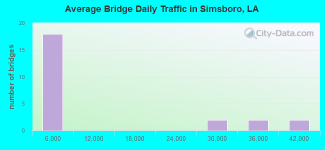
- 216,634Total average daily traffic
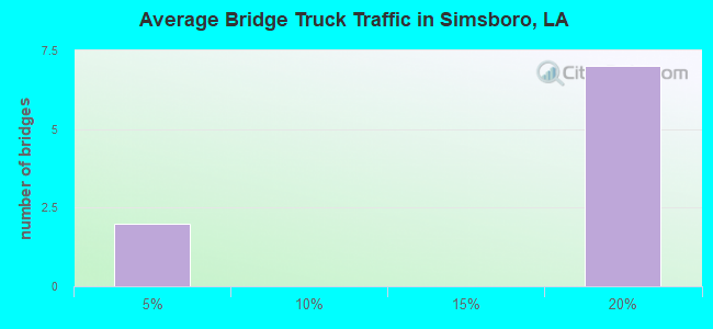
- 1,657Total average daily truck traffic
- National Bridge Inventory (NBI) Registered Bridges for Simsboro
- No street view available for this location
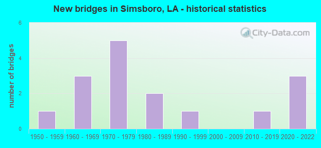
- New bridges - historical statistics
- 11950-1959
- 31960-1969
- 51970-1979
- 21980-1989
- 11990-1999
- 12010-2019
- 32020-2022
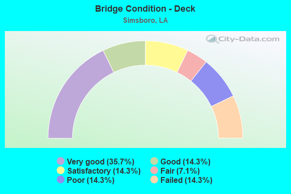
- Bridge Condition - Deck
- 35.7%Very good
- 14.3%Good
- 14.3%Satisfactory
- 7.1%Fair
- 14.3%Poor
- 14.3%Failed
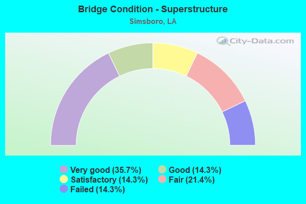
- Bridge Condition - Superstructure
- 35.7%Very good
- 14.3%Good
- 14.3%Satisfactory
- 21.4%Fair
- 14.3%Failed
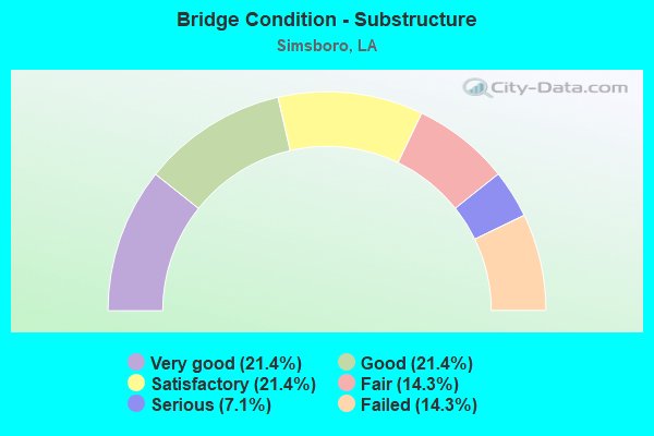
- Bridge Condition - Substructure
- 21.4%Very good
- 21.4%Good
- 21.4%Satisfactory
- 14.3%Fair
- 7.1%Serious
- 14.3%Failed
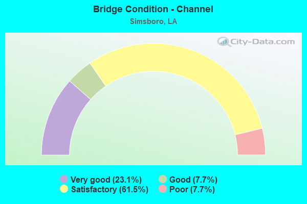
- Bridge Condition - Channel
- 23.1%Very good
- 7.7%Good
- 61.5%Satisfactory
- 7.7%Poor
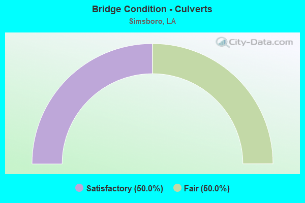
- Bridge Condition - Culverts
- 50.0%Satisfactory
- 50.0%Fair
Find on map >> Show street view
Structure Number: 53100000050018, Location: 1.2 MI W OF LA 507 (Lat: 32.502900, Lng: -92.827700), Route carried "on" structure: County highway , Year Built: 2019, Status: Open, Structure Length: 3.05m (10.01ft), Average Daily Traffic: 150 (year 1980), Truck Traffic: 2%, Average Future Daily Traffic: 165 (year 2036), Design Load: HL 93, Features Intersected: W BRANCH DUGDEMONA RIVER, Facility Carried by Structure: EAVES RD
Minimum Vertical Clearance: 30+ m (98+ ft), Kilometerpoint: 3.911, Lanes on structure: 2, Owner: County Highway Agency, Approaching Roadway Width: 6.1m (20.0ft), Material/Design: Concrete, Design/Construction: Slab, Number Of Spans In Main Unit: 5, Length of Maximum Span: 6.1m (20.0ft), Curb-To-Curb Width: 7.2m (23.6ft), Out-to-Out Width: 8.1m (26.6ft)
Condition: Deck: Very good, Superstructure: Very good, Substructure: Very good, Channel: Very good, Operating Rating: 56.7 metric tons, Method Used To Determine Operating Rating: Load and Resistance Factor Rating (LRFR) rating reported by rating factor(RF) method using HL-93 loadings, Inventory Rating: 43.7 metric tons, Method Used To Determine Inventory Rating: Load and Resistance Factor Rating (LRFR) rating reported by rating factor(RF) method using HL-93 loadings, Structural Evaluation: Equal to present desirable criteria, Deck Geometry: Meets minimum limits, Waterway Adequacy: Better than present minimum criteria, Approach Roadway Alignment: Equal to present desirable criteria, Designated Inspection Frequency: Every 24 months, Inspection Date: August 2021, Deck Structure Type: Concrete Cast-file-Place
Find on map >> Show street view
Structure Number: 53100000053102, Location: 1.9 Mi. S. of LA 544 (Lat: 32.581239, Lng: -92.824069), Route carried "on" structure: County highway , Year Built: 2020, Status: Open, Structure Length: 3.05m (10.01ft), Average Daily Traffic: 175 (year 2020), Truck Traffic: 3%, Average Future Daily Traffic: 195 (year 2036), Design Load: Greater than HL93, Features Intersected: Walnut Creek, Facility Carried by Structure: Eubanks Rd
Minimum Vertical Clearance: 30+ m (98+ ft), Kilometerpoint: 1.081, Lanes on structure: 2, Owner: County Highway Agency, Approaching Roadway Width: 6.1m (20.0ft), Material/Design: Concrete, Design/Construction: Slab, Number Of Spans In Main Unit: 5, Length of Maximum Span: 6.1m (20.0ft), Curb-To-Curb Width: 7.2m (23.6ft), Out-to-Out Width: 8.1m (26.6ft)
Condition: Deck: Very good, Superstructure: Very good, Substructure: Good, Channel: Good, Operating Rating: 41.8 metric tons, Method Used To Determine Operating Rating: Load and Resistance Factor Rating (LRFR) rating reported by rating factor(RF) method using HL-93 loadings, Inventory Rating: 32.4 metric tons, Method Used To Determine Inventory Rating: Load and Resistance Factor Rating (LRFR) rating reported by rating factor(RF) method using HL-93 loadings, Structural Evaluation: Better than present minimum criteria, Deck Geometry: Meets minimum limits, Waterway Adequacy: Better than present minimum criteria, Approach Roadway Alignment: Meets minimum limits, Designated Inspection Frequency: Every 24 months, Inspection Date: September 2021, Deck Structure Type: Concrete Cast-file-Place
Find on map >> Show street view
Structure Number: 53100000053105, Location: 1.2 Mi. W. of LA 507 (Lat: 32.502911, Lng: -92.827411), Route carried "on" structure: County highway , Year Built: 2021, Status: Open, Structure Length: 2.44m (8.01ft), Average Daily Traffic: 250 (year 2021), Average Future Daily Traffic: 350 (year 2041), Design Load: Greater than HL93, Features Intersected: W. Branch of Dugdemona, Facility Carried by Structure: Eaves Rd
Minimum Vertical Clearance: 30+ m (98+ ft), Kilometerpoint: 3.763, Lanes on structure: 2, Owner: County Highway Agency, Approaching Roadway Width: 6.3m (20.7ft), Material/Design: Concrete, Design/Construction: Slab, Number Of Spans In Main Unit: 4, Length of Maximum Span: 6.1m (20.0ft), Curb-To-Curb Width: 7.3m (24.0ft), Out-to-Out Width: 8.1m (26.6ft)
Condition: Deck: Very good, Superstructure: Very good, Substructure: Very good, Channel: Very good, Operating Rating: 40.2 metric tons, Method Used To Determine Operating Rating: Load and Resistance Factor Rating (LRFR) rating reported by rating factor(RF) method using HL-93 loadings, Inventory Rating: 30.8 metric tons, Method Used To Determine Inventory Rating: Load and Resistance Factor Rating (LRFR) rating reported by rating factor(RF) method using HL-93 loadings, Structural Evaluation: Better than present minimum criteria, Deck Geometry: Somewhat better than minimum adequacy, Waterway Adequacy: Equal to present desirable criteria, Approach Roadway Alignment: Equal to present desirable criteria, Designated Inspection Frequency: Every 24 months, Inspection Date: September 2021, Deck Structure Type: Concrete Precast Panels
Find on map >> Show street view
Structure Number: 53100000053106, Location: 2.6 Miles NW of LA 507 (Lat: 32.567211, Lng: -92.814481), Route carried "on" structure: County highway , Year Built: 2021, Status: Open, Structure Length: 1.83m (6.00ft), Average Daily Traffic: 250 (year 2021), Average Future Daily Traffic: 350 (year 2041), Design Load: Greater than HL93, Features Intersected: Walnut Creek, Facility Carried by Structure: Walnut Creek Rd
Minimum Vertical Clearance: 30+ m (98+ ft), Kilometerpoint: 5.741, Lanes on structure: 2, Owner: County Highway Agency, Approaching Roadway Width: 6.0m (19.7ft), Material/Design: Concrete, Design/Construction: Slab, Number Of Spans In Main Unit: 3, Length of Maximum Span: 6.1m (20.0ft), Curb-To-Curb Width: 7.3m (24.0ft), Out-to-Out Width: 8.0m (26.2ft)
Condition: Deck: Very good, Superstructure: Very good, Substructure: Very good, Channel: Very good, Operating Rating: 40.2 metric tons, Method Used To Determine Operating Rating: Load and Resistance Factor Rating (LRFR) rating reported by rating factor(RF) method using HL-93 loadings, Inventory Rating: 30.8 metric tons, Method Used To Determine Inventory Rating: Load and Resistance Factor Rating (LRFR) rating reported by rating factor(RF) method using HL-93 loadings, Structural Evaluation: Better than present minimum criteria, Deck Geometry: Somewhat better than minimum adequacy, Waterway Adequacy: Equal to present desirable criteria, Approach Roadway Alignment: Equal to present desirable criteria, Designated Inspection Frequency: Every 24 months, Inspection Date: September 2021, Deck Structure Type: Concrete Precast Panels
Find on map >> Show street view
Structure Number: 53100010707471, Location: 1.0 MI EAST OF LA 563 (Lat: 32.521731, Lng: -92.759000), Route carried "on" structure: US 80, Year Built: 1952, Status: Open, Structure Length: 1.10m (3.61ft), Average Daily Traffic: 2,200 (year 2016), Truck Traffic: 15%, Average Future Daily Traffic: 3,740 (year 2036), Design Load: H 15, Features Intersected: CREEK
Minimum Vertical Clearance: 30+ m (98+ ft), Kilometerpoint: 11.977, Lanes on structure: 2, Owner: State Highway Agency, Approaching Roadway Width: 12.2m (40.0ft), Material/Design: Concrete, Design/Construction: Culvert, Number Of Spans In Main Unit: 4, Length of Maximum Span: 2.4m (7.9ft), Curb-To-Curb Width: 7.3m (24.0ft), Out-to-Out Width: 9.1m (29.9ft)
Condition: Channel: Satisfactory, Culverts: Fair, Operating Rating: 29.2 metric tons, Method Used To Determine Operating Rating: Load and Resistance Factor Rating (LRFR) rating reported by rating factor(RF) method using HL-93 loadings, Inventory Rating: 22.7 metric tons, Method Used To Determine Inventory Rating: Load and Resistance Factor Rating (LRFR) rating reported by rating factor(RF) method using HL-93 loadings, Structural Evaluation: Somewhat better than minimum adequacy, Deck Geometry: High priority of replacement, Waterway Adequacy: Better than present minimum criteria, Approach Roadway Alignment: Better than present minimum criteria, Designated Inspection Frequency: Every 24 months, Inspection Date: October 2021, Deck Structure Type: Concrete Cast-file-Place
Find on map >> Show street view
Structure Number: 53102960204641, Location: 4.64 MI EAST OF LA 151 (Lat: 32.591431, Lng: -92.779300), Route carried "on" structure: State highway 544, Year Built: 1980, Status: Open, Structure Length: 1.80m (5.91ft), Average Daily Traffic: 860 (year 2016), Truck Traffic: 19%, Average Future Daily Traffic: 1,411 (year 2036), Design Load: HS 20, Features Intersected: CREEK
Minimum Vertical Clearance: 30+ m (98+ ft), Kilometerpoint: 7.424, Lanes on structure: 2, Owner: State Highway Agency, Approaching Roadway Width: 8.5m (27.9ft), Material/Design: Concrete, Design/Construction: Slab, Number Of Spans In Main Unit: 3, Length of Maximum Span: 5.8m (19.0ft), Curb-To-Curb Width: 9.8m (32.2ft), Out-to-Out Width: 10.7m (35.1ft)
Condition: Deck: Satisfactory, Superstructure: Satisfactory, Substructure: Fair, Channel: Satisfactory, Operating Rating: 61.7 metric tons, Method Used To Determine Operating Rating: Load Factor (LF), Inventory Rating: 37.2 metric tons, Method Used To Determine Inventory Rating: Load Factor (LF), Structural Evaluation: Somewhat better than minimum adequacy, Deck Geometry: Equal to present minimum criteria, Waterway Adequacy: Equal to present desirable criteria, Approach Roadway Alignment: Better than present minimum criteria, Designated Inspection Frequency: Every 24 months, Inspection Date: November 2021, Deck Structure Type: Concrete Precast Panels, Wearing Surface/Protective System: Wearing Surface: Bituminous
Find on map >> Show street view
Structure Number: 53103080402721, Location: 2.72 MI N BIENVILLE PAR (Lat: 32.482811, Lng: -92.812100), Route carried "on" structure: State highway 507, Year Built: 1986, Status: Open, Structure Length: 4.88m (16.01ft), Average Daily Traffic: 560 (year 2016), Truck Traffic: 19%, Average Future Daily Traffic: 986 (year 2036), Design Load: HS 20, Features Intersected: DUGDEMONA RIVER
Minimum Vertical Clearance: 30+ m (98+ ft), Kilometerpoint: 4.057, Lanes on structure: 2, Owner: State Highway Agency, Approaching Roadway Width: 12.8m (42.0ft), Material/Design: Concrete, Design/Construction: Slab, Number Of Spans In Main Unit: 8, Length of Maximum Span: 6.1m (20.0ft), Curb-To-Curb Width: 10.4m (34.1ft), Out-to-Out Width: 11.2m (36.7ft)
Condition: Deck: Good, Superstructure: Good, Substructure: Fair, Channel: Satisfactory, Operating Rating: 68.0 metric tons, Method Used To Determine Operating Rating: Load Factor (LF), Inventory Rating: 40.8 metric tons, Method Used To Determine Inventory Rating: Load Factor (LF), Structural Evaluation: Somewhat better than minimum adequacy, Deck Geometry: Equal to present minimum criteria, Waterway Adequacy: Equal to present desirable criteria, Approach Roadway Alignment: Equal to present minimum criteria, Designated Inspection Frequency: Every 24 months, Underwater Inspection Frequency: Every 60 months, Inspection Date: December 2021, Underwater Inspection Date: August 2020, Deck Structure Type: Concrete Cast-file-Place, Wearing Surface/Protective System: Wearing Surface: Monolithic Concrete
Find on map >> Show street view
Structure Number: 53103080403731, Location: 3.73 MI N BIENVILLE PAR (Lat: 32.495969, Lng: -92.808400), Route carried "on" structure: State highway 507, Year Built: 1979, Status: Open, Structure Length: 0.64m (2.10ft), Average Daily Traffic: 560 (year 2016), Truck Traffic: 19%, Average Future Daily Traffic: 986 (year 2036), Design Load: HS 20, Features Intersected: CREEK
Minimum Vertical Clearance: 30+ m (98+ ft), Kilometerpoint: 5.625, Lanes on structure: 2, Owner: State Highway Agency, Approaching Roadway Width: 12.8m (42.0ft), Material/Design: Steel, Design/Construction: Culvert, Number Of Spans In Main Unit: 2, Length of Maximum Span: 2.4m (7.9ft), Curb-To-Curb Width: 12.8m (42.0ft), Out-to-Out Width: 14.8m (48.6ft)
Condition: Channel: Satisfactory, Culverts: Satisfactory, Operating Rating: 97.2 metric tons, Method Used To Determine Operating Rating: Load and Resistance Factor Rating (LRFR) rating reported by rating factor(RF) method using HL-93 loadings, Inventory Rating: 74.5 metric tons, Method Used To Determine Inventory Rating: Load and Resistance Factor Rating (LRFR) rating reported by rating factor(RF) method using HL-93 loadings, Structural Evaluation: Equal to present minimum criteria, Deck Geometry: Superior to present desirable criteria, Waterway Adequacy: Better than present minimum criteria, Approach Roadway Alignment: Equal to present desirable criteria, Designated Inspection Frequency: Every 24 months, Inspection Date: December 2021
Find on map >> Show street view
Structure Number: 53103080407701, Location: LA 507 OVER I-20 (Lat: 32.548039, Lng: -92.787500), Route carried "on" structure: State highway 507, Year Built: 1963, Status: Open, Structure Length: 7.83m (25.69ft), Average Daily Traffic: 2,500 (year 2016), Truck Traffic: 19%, Average Future Daily Traffic: 4,250 (year 2036), Design Load: HS 20, Features Intersected: LA 507 OVER I-20
Minimum Vertical Clearance: 30+ m (98+ ft), Kilometerpoint: 12.080, Lanes on structure: 2, Lanes under structure: 4, Owner: State Highway Agency, Approaching Roadway Width: 9.8m (32.2ft), Material/Design: Steel, Design/Construction: Stringer/Multi-beam, Number Of Spans In Main Unit: 4, Length of Maximum Span: 24.4m (80.1ft), Curb-To-Curb Width: 8.5m (27.9ft), Out-to-Out Width: 9.3m (30.5ft)
Condition: Deck: Very good, Superstructure: Very good, Substructure: Good, Operating Rating: 34.0 metric tons, Method Used To Determine Operating Rating: Load and Resistance Factor Rating (LRFR) rating reported by rating factor(RF) method using HL-93 loadings, Inventory Rating: 26.2 metric tons, Method Used To Determine Inventory Rating: Load and Resistance Factor Rating (LRFR) rating reported by rating factor(RF) method using HL-93 loadings, Structural Evaluation: Equal to present minimum criteria, Deck Geometry: Meets minimum limits, Underclear: High priority of replacement, Approach Roadway Alignment: Equal to present desirable criteria, Length Of Structure Improvement: 8.75m (28.71ft), Designated Inspection Frequency: Every 24 months, Inspection Date: November 2021, Bridge Improvement Cost: $746,000, Roadway Improvement Cost: $74,000, Total Project Cost: $1,119,000 ( Estimate for 2016), Deck Structure Type: Concrete Cast-file-Place, Wearing Surface/Protective System: Wearing Surface: Monolithic Concrete
Find on map >> Show street view
Structure Number: 53103160403171, Location: 3.17 MI WEST OF US 80 (Lat: 32.497261, Lng: -92.764200), Route carried "on" structure: State highway 3005, Year Built: 1977, Status: Open, Structure Length: 2.93m (9.61ft), Average Daily Traffic: 1,220 (year 2016), Truck Traffic: 15%, Average Future Daily Traffic: 2,074 (year 2036), Design Load: HS 20, Features Intersected: MADDEN CREEK BR.
Minimum Vertical Clearance: 30+ m (98+ ft), Kilometerpoint: 4.907, Lanes on structure: 2, Owner: State Highway Agency, Approaching Roadway Width: 10.4m (34.1ft), Material/Design: Concrete, Design/Construction: Slab, Number Of Spans In Main Unit: 5, Length of Maximum Span: 5.8m (19.0ft), Curb-To-Curb Width: 8.5m (27.9ft), Out-to-Out Width: 9.6m (31.5ft)
Condition: Deck: Satisfactory, Superstructure: Satisfactory, Substructure: Satisfactory, Channel: Satisfactory, Operating Rating: 65.3 metric tons, Method Used To Determine Operating Rating: Load Factor (LF), Inventory Rating: 39.0 metric tons, Method Used To Determine Inventory Rating: Load Factor (LF), Structural Evaluation: Equal to present minimum criteria, Deck Geometry: Somewhat better than minimum adequacy, Waterway Adequacy: Equal to present desirable criteria, Approach Roadway Alignment: Equal to present desirable criteria, Designated Inspection Frequency: Every 24 months, Inspection Date: November 2021, Deck Structure Type: Concrete Precast Panels, Wearing Surface/Protective System: Wearing Surface: Monolithic Concrete
Find on map >> Show street view
Structure Number: 53103160500991, Location: LA 563 OVER I-20 (Lat: 32.546411, Lng: -92.766600), Route carried "on" structure: State highway 563, Year Built: 1963, Status: Posted for load, Structure Length: 7.53m (24.70ft), Average Daily Traffic: 1,510 (year 2016), Truck Traffic: 19%, Average Future Daily Traffic: 2,550 (year 2036), Design Load: HS 20, Features Intersected: LA 563 OVER I-20
Minimum Vertical Clearance: 30+ m (98+ ft), Kilometerpoint: 1.580, Lanes on structure: 2, Lanes under structure: 4, Owner: State Highway Agency, Approaching Roadway Width: 7.3m (24.0ft), Material/Design: Steel, Design/Construction: Stringer/Multi-beam, Number Of Spans In Main Unit: 4, Length of Maximum Span: 21.3m (69.9ft), Curb-To-Curb Width: 7.3m (24.0ft), Out-to-Out Width: 7.9m (25.9ft)
Condition: Deck: Poor, Superstructure: Fair, Substructure: Satisfactory, Operating Rating: 23.3 metric tons, Method Used To Determine Operating Rating: Load and Resistance Factor Rating (LRFR) rating reported by rating factor(RF) method using HL-93 loadings, Inventory Rating: 17.8 metric tons, Method Used To Determine Inventory Rating: Load and Resistance Factor Rating (LRFR) rating reported by rating factor(RF) method using HL-93 loadings, Structural Evaluation: Meets minimum limits, Deck Geometry: Meets minimum limits, Underclear: High priority of replacement, Approach Roadway Alignment: Equal to present desirable criteria, Bridge Posting: Required (Relationship of Operating Rating to Maximum Legal Load: 20.0 - 29.9% below), Length Of Structure Improvement: 8.44m (27.69ft), Designated Inspection Frequency: Every 24 months, Other Special Inspection Frequency: Every 12 months, Inspection Date: November 2021, Other Special Inspection Date: November 2020, Bridge Improvement Cost: $720,000, Roadway Improvement Cost: $72,000, Total Project Cost: $1,080,000 ( Estimate for 2016), Deck Structure Type: Concrete Cast-file-Place, Wearing Surface/Protective System: Wearing Surface: Monolithic Concrete
Find on map >> Show street view
Structure Number: 53104510504731, Location: .9 MI WEST OF LA 507 (Lat: 32.547911, Lng: -92.800600), Route carried "on" structure: County highway , Year Built: 1963, Status: Posted for load, Structure Length: 8.75m (28.71ft), Average Daily Traffic: 2,930 (year 2015), Average Future Daily Traffic: 4,981 (year 2036), Design Load: H 15, Features Intersected: I 20, Facility Carried by Structure: WALNUT CR RD
Minimum Vertical Clearance: 30+ m (98+ ft), Kilometerpoint: 7.557, Lanes on structure: 2, Lanes under structure: 4, Base Highway Network: Yes (Inventory Route: 451-05-1, Subroute: 10), Owner: State Highway Agency, Approaching Roadway Width: 9.1m (29.9ft), Skew: 3 degrees, Material/Design: Steel, Design/Construction: Stringer/Multi-beam, Number Of Spans In Main Unit: 3, Number Of Approach Spans: 2, Length of Maximum Span: 24.4m (80.1ft), Curb-To-Curb Width: 7.3m (24.0ft), Out-to-Out Width: 9.0m (29.5ft)
Condition: Deck: Fair, Superstructure: Fair, Substructure: Satisfactory, Operating Rating: 16.8 metric tons, Method Used To Determine Operating Rating: Load and Resistance Factor Rating (LRFR) rating reported by rating factor(RF) method using HL-93 loadings, Inventory Rating: 13.0 metric tons, Method Used To Determine Inventory Rating: Load and Resistance Factor Rating (LRFR) rating reported by rating factor(RF) method using HL-93 loadings, Structural Evaluation: Meets minimum limits, Deck Geometry: High priority of replacement, Underclear: High priority of replacement, Approach Roadway Alignment: Better than present minimum criteria, Bridge Posting: Required (Relationship of Operating Rating to Maximum Legal Load: 30.0 - 39.9% below), Length Of Structure Improvement: 9.66m (31.69ft), Designated Inspection Frequency: Every 24 months, Other Special Inspection Frequency: Every 12 months, Inspection Date: December 2021, Other Special Inspection Date: December 2020, Bridge Improvement Cost: $824,000, Roadway Improvement Cost: $82,000, Total Project Cost: $1,236,000 ( Estimate for 2016), Deck Structure Type: Concrete Cast-file-Place, Wearing Surface/Protective System: Wearing Surface: Monolithic Concrete
Find on map >> Show street view
Structure Number: 53132289924651, Location: 3 MI S SIMMSBORO (Lat: 32.482189, Lng: -92.774039), Route carried "on" structure: County highway , Year Built: 1977, Status: Posted for load, Structure Length: 1.77m (5.81ft), Average Daily Traffic: 155 (year 1979), Average Future Daily Traffic: 263 (year 2036), Design Load: H 20, Features Intersected: MADDEN CREEK, Facility Carried by Structure: MONDY RD
Minimum Vertical Clearance: 30+ m (98+ ft), Kilometerpoint: 0.000, Lanes on structure: 2, Owner: County Highway Agency, Approaching Roadway Width: 8.5m (27.9ft), Material/Design: Wood or Timber, Design/Construction: Stringer/Multi-beam, Number Of Spans In Main Unit: 3, Length of Maximum Span: 5.8m (19.0ft), Curb-To-Curb Width: 6.9m (22.6ft), Out-to-Out Width: 7.7m (25.3ft)
Condition: Deck: Poor, Superstructure: Fair, Substructure: Serious, Channel: Satisfactory, Operating Rating: 14.5 metric tons, Method Used To Determine Operating Rating: Allowable Stress (AS), Inventory Rating: 7.3 metric tons, Method Used To Determine Inventory Rating: Allowable Stress (AS), Structural Evaluation: High priority of corrective action, Deck Geometry: Meets minimum limits, Waterway Adequacy: Better than present minimum criteria, Approach Roadway Alignment: Equal to present desirable criteria, Bridge Posting: Required (Relationship of Operating Rating to Maximum Legal Load: 30.0 - 39.9% below), Designated Inspection Frequency: Every 24 months, Other Special Inspection Frequency: Every 12 months, Inspection Date: September 2021, Deck Structure Type: Wood or Timber, Wearing Surface/Protective System: Wearing Surface: Bituminous
Find on map >> Show street view
Structure Number: 53132311924901, Location: 2 MI SW OF SIMMSBORO (Lat: 32.519261, Lng: -92.813219), Route carried "on" structure: County highway , Year Built: 1977, Status: Temporarily open, Structure Length: 1.19m (3.90ft), Average Daily Traffic: 50 (year 1979), Average Future Daily Traffic: 85 (year 2036), Design Load: H 20, Features Intersected: DUGDEMONA RIVER, Facility Carried by Structure: CENTERPOINT RD
Minimum Vertical Clearance: 30+ m (98+ ft), Kilometerpoint: 0.000, Lanes on structure: 2, Owner: County Highway Agency, Approaching Roadway Width: 7.9m (25.9ft), Material/Design: Wood or Timber, Design/Construction: Stringer/Multi-beam, Number Of Spans In Main Unit: 2, Length of Maximum Span: 5.8m (19.0ft), Curb-To-Curb Width: 6.9m (22.6ft), Out-to-Out Width: 7.7m (25.3ft)
Condition: Deck: Failed, Superstructure: Failed, Substructure: Failed, Channel: Satisfactory, Deck Geometry: Somewhat better than minimum adequacy, Waterway Adequacy: Better than present minimum criteria, Approach Roadway Alignment: Equal to present desirable criteria, Bridge Posting: Required (Relationship of Operating Rating to Maximum Legal Load: > 39.9% below), Designated Inspection Frequency: Every 24 months, Inspection Date: September 2021, Deck Structure Type: Wood or Timber, Wearing Surface/Protective System: Wearing Surface: Bituminous
Find on map >> Show street view
Structure Number: 53132311925011, Location: 2.1 MI E of LA 507 (Lat: 32.518950, Lng: -92.835031), Route carried "on" structure: County highway , Year Built: 1999, Status: Open, Structure Length: 1.74m (5.71ft), Average Daily Traffic: 35 (year 1979), Average Future Daily Traffic: 59 (year 2036), Design Load: HS 20, Features Intersected: WEST BRANCH DUGEDEMONLA, Facility Carried by Structure: CENTERPOINT RD
Minimum Vertical Clearance: 30+ m (98+ ft), Kilometerpoint: 0.000, Lanes on structure: 2, Base Highway Network: Yes, Owner: County Highway Agency, Approaching Roadway Width: 11.0m (36.1ft), Material/Design: Concrete, Design/Construction: Slab, Number Of Spans In Main Unit: 3, Length of Maximum Span: 5.8m (19.0ft), Curb-To-Curb Width: 8.5m (27.9ft), Out-to-Out Width: 9.4m (30.8ft)
Condition: Deck: Good, Superstructure: Good, Substructure: Good, Channel: Satisfactory, Operating Rating: 36.9 metric tons, Method Used To Determine Operating Rating: Load and Resistance Factor Rating (LRFR) rating reported by rating factor(RF) method using HL-93 loadings, Inventory Rating: 28.5 metric tons, Method Used To Determine Inventory Rating: Load and Resistance Factor Rating (LRFR) rating reported by rating factor(RF) method using HL-93 loadings, Structural Evaluation: Better than present minimum criteria, Deck Geometry: Better than present minimum criteria, Waterway Adequacy: Equal to present desirable criteria, Approach Roadway Alignment: Equal to present minimum criteria, Designated Inspection Frequency: Every 24 months, Inspection Date: September 2021, Deck Structure Type: Concrete Cast-file-Place
Find on map >> Show street view
Structure Number: 53132351924681, Location: 3 MI N SIMSBORO (Lat: 32.586561, Lng: -92.779181), Route carried "on" structure: County highway , Year Built: 1978, Status: Temporarily open, Structure Length: 1.19m (3.90ft), Average Daily Traffic: 77 (year 1979), Average Future Daily Traffic: 130 (year 2036), Design Load: H 20, Features Intersected: LITTLE CREEK, Facility Carried by Structure: MITCHELL RD
Minimum Vertical Clearance: 30+ m (98+ ft), Kilometerpoint: 0.000, Lanes on structure: 2, Owner: County Highway Agency, Approaching Roadway Width: 11.0m (36.1ft), Material/Design: Wood or Timber, Design/Construction: Stringer/Multi-beam, Number Of Spans In Main Unit: 2, Length of Maximum Span: 5.8m (19.0ft), Curb-To-Curb Width: 7.0m (23.0ft), Out-to-Out Width: 7.4m (24.3ft)
Condition: Deck: Failed, Superstructure: Failed, Substructure: Failed, Channel: Poor, Deck Geometry: Somewhat better than minimum adequacy, Waterway Adequacy: Better than present minimum criteria, Approach Roadway Alignment: Equal to present minimum criteria, Bridge Posting: Required (Relationship of Operating Rating to Maximum Legal Load: > 39.9% below), Designated Inspection Frequency: Every 24 months, Inspection Date: September 2021, Deck Structure Type: Wood or Timber, Wearing Surface/Protective System: Wearing Surface: Bituminous
Find on map >> Show street view
Structure Number: 53103080407701, Location: 5.1 MI E OF BIENVILLE PL. (Lat: 32.548261, Lng: -92.787500), Route carried "under" structure: Interstate 20, Structure Length: 0. m, Average Daily Traffic: 29,400 (year 2014), Features Intersected: LA 507 OVER I-20 EB
Minimum Vertical Clearance: 5.43m (17.81ft), Kilometerpoint: 8.808, Lanes on structure: 2, Length of Maximum Span: 0.0m
Find on map >> Show street view
Structure Number: 53103080407701, Location: 5.1 MI E OF BEINVILLE PL. (Lat: 32.548500, Lng: -92.787419), Route carried "under" structure: Interstate 20, Structure Length: 0. m, Average Daily Traffic: 29,400 (year 2014), Features Intersected: LA 507 OVER I-20 WB
Minimum Vertical Clearance: 5.00m (16.40ft), Kilometerpoint: 35.195, Lanes on structure: 3, Length of Maximum Span: 0.0m
Find on map >> Show street view
Structure Number: 53103160500991, Location: 1.2 MI E OF LA 507 (Lat: 32.546611, Lng: -92.766689), Route carried "under" structure: Interstate 20, Structure Length: 0. m, Average Daily Traffic: 1,500 (year 2015), Features Intersected: I-20 EB UNDER LA 563
Minimum Vertical Clearance: 5.06m (16.60ft), Kilometerpoint: 10.773, Lanes on structure: 2, Length of Maximum Span: 0.0m
Find on map >> Show street view
Structure Number: 53103160500991, Location: 1.2 MI E OF LA 507 (Lat: 32.546900, Lng: -92.766569), Route carried "under" structure: Interstate 20, Structure Length: 0. m, Average Daily Traffic: 1,500 (year 2015), Features Intersected: I-20 WB UNDER LA 563
Minimum Vertical Clearance: 5.09m (16.70ft), Kilometerpoint: 33.230, Lanes on structure: 2, Length of Maximum Span: 0.0m
Find on map >> Show street view
Structure Number: 53104510501901, Location: 4.779 MI W OF LA 563 (Lat: 32.551389, Lng: -92.848111), Route carried "under" structure: Interstate 20, Structure Length: 0. m, Average Daily Traffic: 36,700 (year 2017), Features Intersected: I-20 WB UNDER WALNUT CR.
Minimum Vertical Clearance: 4.85m (15.91ft), Kilometerpoint: 40.926, Lanes on structure: 2, Lanes under structure: 2, Length of Maximum Span: 0.0m
Find on map >> Show street view
Structure Number: 53104510501901, Location: 4.779 MI W OF LA 563 (Lat: 32.551211, Lng: -92.848450), Route carried "under" structure: Interstate 20, Structure Length: 0. m, Average Daily Traffic: 36,700 (year 2017), Features Intersected: I-20 EB UNDER WALNUT CR.
Minimum Vertical Clearance: 5.21m (17.09ft), Kilometerpoint: 3.035, Lanes on structure: 2, Lanes under structure: 2, Length of Maximum Span: 0.0m
Find on map >> Show street view
Structure Number: 53104510504731, Location: 4.7 MI E OF BIENVILLE P.L (Lat: 32.548081, Lng: -92.800811), Route carried "under" structure: Interstate 20, Structure Length: 0. m, Average Daily Traffic: 33,976 (year 2014), Features Intersected: I-20 EB UNDER WALNUT CRE
Minimum Vertical Clearance: 4.85m (15.91ft), Kilometerpoint: 7.554, Lanes on structure: 2, Length of Maximum Span: 0.0m
Find on map >> Show street view
Structure Number: 53104510504731, Location: 4.7 MI E OF BIENVILLE P.L (Lat: 32.548581, Lng: -92.801061), Route carried "under" structure: Interstate 20, Structure Length: 0. m, Average Daily Traffic: 33,976 (year 2014), Features Intersected: I-20 WB UNDER WALNUT CRE
Minimum Vertical Clearance: 5.55m (18.21ft), Kilometerpoint: 36.453, Lanes on structure: 2, Length of Maximum Span: 0.0m