Bridge Statistics for Sioux City, Iowa (IA)
Condition, Traffic, Stress, Structural Evaluation, Project Costs
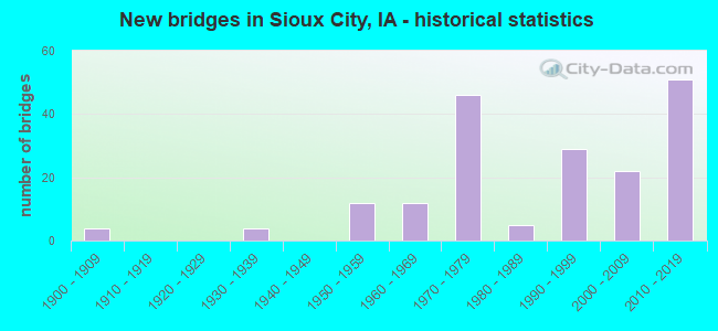
- New bridges - historical statistics
- 41900-1909
- 41930-1939
- 121950-1959
- 121960-1969
- 461970-1979
- 51980-1989
- 291990-1999
- 222000-2009
- 512010-2019
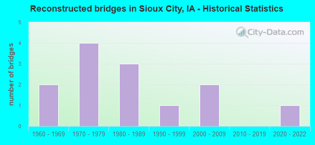
- Reconstructed bridges - Historical Statistics
- 21960-1969
- 41970-1979
- 31980-1989
- 11990-1999
- 22000-2009
- 02010-2019
- 12020-2022
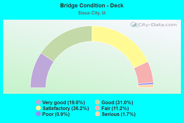
- Bridge Condition - Deck
- 19.0%Very good
- 31.0%Good
- 36.2%Satisfactory
- 11.2%Fair
- 0.9%Poor
- 1.7%Serious
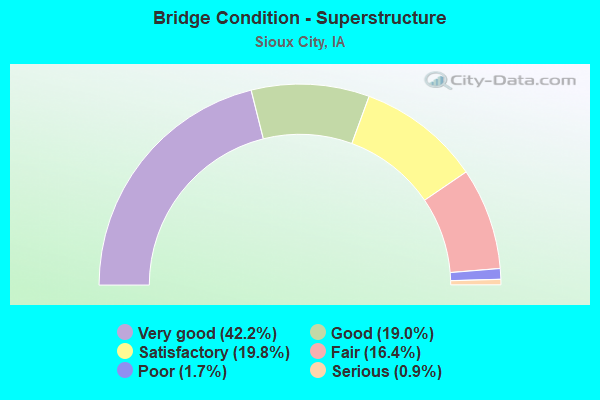
- Bridge Condition - Superstructure
- 42.2%Very good
- 19.0%Good
- 19.8%Satisfactory
- 16.4%Fair
- 1.7%Poor
- 0.9%Serious
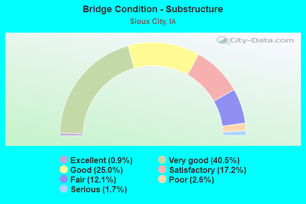
- Bridge Condition - Substructure
- 0.9%Excellent
- 40.5%Very good
- 25.0%Good
- 17.2%Satisfactory
- 12.1%Fair
- 2.6%Poor
- 1.7%Serious
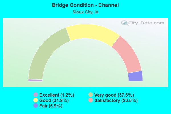
- Bridge Condition - Channel
- 1.2%Excellent
- 37.6%Very good
- 31.8%Good
- 23.5%Satisfactory
- 5.9%Fair
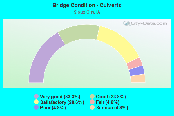
- Bridge Condition - Culverts
- 33.3%Very good
- 23.8%Good
- 28.6%Satisfactory
- 4.8%Fair
- 4.8%Poor
- 4.8%Serious
Find on map >> Show street view
Structure Number: 60768, Location: 0.1 mi. N of 46 St./D12 (Lat: 42.549686, Lng: -96.341006), Route carried "on" structure: US 75, Year Built: 2000, Status: Open, Structure Length: 0.67m (2.20ft), Average Daily Traffic: 9,500 (year 2020), Truck Traffic: 17%, Average Future Daily Traffic: 9,500 (year 2040), Design Load: HS 20, Features Intersected: STREAM
Minimum Vertical Clearance: 30+ m (98+ ft), Kilometerpoint: 16.116, Lanes on structure: 4, Base Highway Network: Yes, Owner: State Highway Agency, Approaching Roadway Width: 25.0m (82.0ft), Skew: 22 degrees, Material/Design: Concrete continuous, Design/Construction: Culvert, Number Of Spans In Main Unit: 2, Length of Maximum Span: 3.0m (9.8ft)
Condition: Channel: Very good, Culverts: Good, Structural Evaluation: Better than present minimum criteria, Waterway Adequacy: Equal to present desirable criteria, Approach Roadway Alignment: Superior to present desirable criteria, Designated Inspection Frequency: Every 24 months, Inspection Date: December 2020
Find on map >> Show street view
Structure Number: 607685, Location: 0.1 mi. E of jct US 75 (Lat: 42.547483, Lng: -96.338389), Route carried "on" structure: City street , Year Built: 2000, Status: Open, Structure Length: 0.64m (2.10ft), Average Daily Traffic: 1,800 (year 2019), Average Future Daily Traffic: 1,800 (year 2040), Design Load: HS 20, Features Intersected: STREAM, Facility Carried by Structure: TAFT ST
Minimum Vertical Clearance: 30+ m (98+ ft), Kilometerpoint: 1.138, Lanes on structure: 2, Owner: State Highway Agency, Approaching Roadway Width: 11.0m (36.1ft), Material/Design: Concrete continuous, Design/Construction: Culvert, Number Of Spans In Main Unit: 2, Length of Maximum Span: 3.0m (9.8ft)
Condition: Channel: Good, Culverts: Very good, Operating Rating: 44.1 metric tons, Method Used To Determine Operating Rating: Field evaluation and documented engineering judgment, Inventory Rating: 32.7 metric tons, Method Used To Determine Inventory Rating: Field evaluation and documented engineering judgment, Structural Evaluation: Equal to present desirable criteria, Waterway Adequacy: Equal to present desirable criteria, Approach Roadway Alignment: Equal to present desirable criteria, Designated Inspection Frequency: Every 24 months, Inspection Date: December 2020
Find on map >> Show street view
Structure Number: 60798, Location: 5.8 mi. N of IA 12 (Lat: 42.553806, Lng: -96.341508), Route carried "on" structure: US 75, Year Built: 1999, Status: Open, Structure Length: 23.07m (75.69ft), Average Daily Traffic: 4,750 (year 2020), Truck Traffic: 17%, Average Future Daily Traffic: 4,750 (year 2041), Design Load: HS 20+Mod, Features Intersected: RAILROAD & RAMP
Minimum Vertical Clearance: 30+ m (98+ ft), Kilometerpoint: 111.930, Lanes on structure: 2, Lanes under structure: 2, Owner: State Highway Agency, Approaching Roadway Width: 12.2m (40.0ft), Material/Design: Steel continuous, Design/Construction: Stringer/Multi-beam, Number Of Spans In Main Unit: 5, Length of Maximum Span: 51.8m (169.9ft), Curb-To-Curb Width: 12.2m (40.0ft), Out-to-Out Width: 13.2m (43.3ft)
Condition: Deck: Satisfactory, Superstructure: Good, Substructure: Good, Operating Rating: 44.4 metric tons, Method Used To Determine Operating Rating: Load Factor (LF), Inventory Rating: 32.7 metric tons, Method Used To Determine Inventory Rating: Load Factor (LF), Structural Evaluation: Better than present minimum criteria, Deck Geometry: Better than present minimum criteria, Underclear: Equal to present minimum criteria, Approach Roadway Alignment: Equal to present desirable criteria, Designated Inspection Frequency: Every 24 months, Inspection Date: October 2021, Deck Structure Type: Concrete Cast-file-Place, Wearing Surface/Protective System: Wearing Surface: Monolithic Concrete, Deck Protection: Epoxy Coated Reinforcing
Find on map >> Show street view
Structure Number: 607985, Location: 5.8 mi. N of Jct. IA 12 (Lat: 42.551756, Lng: -96.341303), Route carried "on" structure: US 75, Year Built: 1999, Status: Open, Structure Length: 26.12m (85.70ft), Average Daily Traffic: 4,750 (year 2020), Truck Traffic: 17%, Average Future Daily Traffic: 4,750 (year 2041), Design Load: HS 20, Features Intersected: BUS 75
Minimum Vertical Clearance: 30+ m (98+ ft), Kilometerpoint: 16.346, Lanes on structure: 2, Lanes under structure: 2, Base Highway Network: Yes, Owner: State Highway Agency, Approaching Roadway Width: 12.2m (40.0ft), Material/Design: Steel continuous, Design/Construction: Stringer/Multi-beam, Number Of Spans In Main Unit: 5, Length of Maximum Span: 67.1m (220.1ft), Curb-To-Curb Width: 12.2m (40.0ft), Out-to-Out Width: 13.2m (43.3ft)
Condition: Deck: Satisfactory, Superstructure: Good, Substructure: Good, Operating Rating: 65.8 metric tons, Method Used To Determine Operating Rating: Load Factor (LF), Inventory Rating: 39.5 metric tons, Method Used To Determine Inventory Rating: Load Factor (LF), Structural Evaluation: Better than present minimum criteria, Deck Geometry: Better than present minimum criteria, Underclear: Better than present minimum criteria, Approach Roadway Alignment: Better than present minimum criteria, Designated Inspection Frequency: Every 24 months, Inspection Date: October 2021, Deck Structure Type: Concrete Cast-file-Place, Wearing Surface/Protective System: Wearing Surface: Monolithic Concrete, Deck Protection: Epoxy Coated Reinforcing
Find on map >> Show street view
Structure Number: 608835, Location: 0.1 mi. N of SR D12 (Lat: 42.549644, Lng: -96.346700), Route carried "on" structure: Ramp State highway 376, Year Built: 2001, Status: Open, Structure Length: 0.88m (2.89ft), Average Daily Traffic: 1,420 (year 2020), Truck Traffic: 1%, Average Future Daily Traffic: 1,420 (year 2042), Design Load: HS 20, Features Intersected: DRAINAGE
Minimum Vertical Clearance: 30+ m (98+ ft), Kilometerpoint: 0.264, Lanes on structure: 1, Owner: State Highway Agency, Approaching Roadway Width: 7.9m (25.9ft), Skew: 4 degrees, Material/Design: Concrete continuous, Design/Construction: Culvert, Number Of Spans In Main Unit: 2, Length of Maximum Span: 4.3m (14.1ft)
Condition: Channel: Very good, Culverts: Good, Operating Rating: 44.1 metric tons, Method Used To Determine Operating Rating: Load and Resistance Factor Rating (LRFR) rating reported by rating factor(RF) method using HL-93 loadings, Inventory Rating: 34.0 metric tons, Method Used To Determine Inventory Rating: Load and Resistance Factor Rating (LRFR) rating reported by rating factor(RF) method using HL-93 loadings, Structural Evaluation: Better than present minimum criteria, Waterway Adequacy: Equal to present desirable criteria, Approach Roadway Alignment: Equal to present desirable criteria, Designated Inspection Frequency: Every 24 months, Inspection Date: January 2022
Find on map >> Show street view
Structure Number: 700205, Location: At Jct. IA 12 (Lat: 42.491914, Lng: -96.412597), Route carried "on" structure: City street , Year Built: 2012, Status: Open, Structure Length: 6.25m (20.51ft), Average Daily Traffic: 15,500 (year 2018), Average Future Daily Traffic: 15,500 (year 2040), Design Load: HL 93, Features Intersected: TRI-VIEW & BNSF RR, Facility Carried by Structure: WESLEY PKWY
Minimum Vertical Clearance: 30+ m (98+ ft), Kilometerpoint: 0.513, Lanes on structure: 3, Lanes under structure: 2, Owner: State Highway Agency, Approaching Roadway Width: 11.1m (36.4ft), Skew: 22 degrees, Material/Design: Prestressed concrete, Design/Construction: Stringer/Multi-beam, Number Of Spans In Main Unit: 2, Length of Maximum Span: 38.4m (126.0ft), Curb or Sidewalk Widths: Left: 0.0m, Right: 3.3m (10.8ft), Curb-To-Curb Width: 30.3m (99.4ft), Out-to-Out Width: 39.8m (130.6ft)
Condition: Deck: Satisfactory, Superstructure: Very good, Substructure: Very good, Operating Rating: 43.1 metric tons, Method Used To Determine Operating Rating: Assigned ratings based on Load and Resistance Factor Design (LRFD) reported by rating factor (RF) using HL93 loadings, Inventory Rating: 32.4 metric tons, Method Used To Determine Inventory Rating: Assigned ratings based on Load and Resistance Factor Design (LRFD) reported by rating factor (RF) using HL93 loadings, Structural Evaluation: Equal to present desirable criteria, Deck Geometry: Superior to present desirable criteria, Underclear: Meets minimum limits, Approach Roadway Alignment: Equal to present desirable criteria, Designated Inspection Frequency: Every 24 months, Inspection Date: December 2020, Deck Structure Type: Concrete Cast-file-Place, Wearing Surface/Protective System: Wearing Surface: Monolithic Concrete, Deck Protection: Epoxy Coated Reinforcing
Find on map >> Show street view
Structure Number: 700305, Location: 3.5 Mi. N of N Jct. US 75 (Lat: 42.483244, Lng: -96.390675), Route carried "on" structure: Interstate 29, Year Built: 2016, Status: Open, Structure Length: 19.91m (65.32ft), Average Daily Traffic: 14,000 (year 2020), Truck Traffic: 20%, Average Future Daily Traffic: 14,000 (year 2040), Design Load: HL 93, Features Intersected: FLOYD RIVER
Minimum Vertical Clearance: 30+ m (98+ ft), Kilometerpoint: 237.018, Lanes on structure: 3, Base Highway Network: Yes, Owner: State Highway Agency, Approaching Roadway Width: 19.2m (63.0ft), Skew: 3 degrees, Material/Design: Prestressed concrete, Design/Construction: Stringer/Multi-beam, Number Of Spans In Main Unit: 6, Length of Maximum Span: 38.3m (125.7ft), Curb-To-Curb Width: 18.7m (61.4ft), Out-to-Out Width: 19.7m (64.6ft)
Condition: Deck: Satisfactory, Superstructure: Good, Substructure: Very good, Channel: Very good, Operating Rating: 42.1 metric tons, Method Used To Determine Operating Rating: Assigned ratings based on Load and Resistance Factor Design (LRFD) reported by rating factor (RF) using HL93 loadings, Inventory Rating: 32.4 metric tons, Method Used To Determine Inventory Rating: Assigned ratings based on Load and Resistance Factor Design (LRFD) reported by rating factor (RF) using HL93 loadings, Structural Evaluation: Better than present minimum criteria, Deck Geometry: Superior to present desirable criteria, Waterway Adequacy: Superior to present desirable criteria, Approach Roadway Alignment: Equal to present desirable criteria, Designated Inspection Frequency: Every 24 months, Inspection Date: December 2020, Deck Structure Type: Concrete Cast-file-Place, Wearing Surface/Protective System: Wearing Surface: Monolithic Concrete, Deck Protection: Epoxy Coated Reinforcing
Find on map >> Show street view
Structure Number: 70031, Location: 3.0 mi. N of jct. U.S. 75 (Lat: 42.486744, Lng: -96.394819), Route carried "on" structure: Interstate 29, Year Built: 2018, Status: Open, Structure Length: 6.92m (22.70ft), Average Daily Traffic: 12,450 (year 2020), Truck Traffic: 20%, Average Future Daily Traffic: 12,450 (year 2040), Design Load: HL 93, Features Intersected: FLOYD BLVD
Minimum Vertical Clearance: 30+ m (98+ ft), Kilometerpoint: 237.538, Lanes on structure: 2, Lanes under structure: 5, Base Highway Network: Yes, Owner: State Highway Agency, Approaching Roadway Width: 11.0m (36.1ft), Skew: 1 degrees, Material/Design: Prestressed concrete, Design/Construction: Stringer/Multi-beam, Number Of Spans In Main Unit: 3, Length of Maximum Span: 32.6m (107.0ft), Curb-To-Curb Width: 18.7m (61.4ft), Out-to-Out Width: 19.7m (64.6ft)
Condition: Deck: Good, Superstructure: Very good, Substructure: Very good, Operating Rating: 42.1 metric tons, Method Used To Determine Operating Rating: Assigned ratings based on Load and Resistance Factor Design (LRFD) reported by rating factor (RF) using HL93 loadings, Inventory Rating: 32.4 metric tons, Method Used To Determine Inventory Rating: Assigned ratings based on Load and Resistance Factor Design (LRFD) reported by rating factor (RF) using HL93 loadings, Structural Evaluation: Equal to present desirable criteria, Deck Geometry: Superior to present desirable criteria, Underclear: Equal to present minimum criteria, Approach Roadway Alignment: Equal to present desirable criteria, Designated Inspection Frequency: Every 24 months, Inspection Date: December 2020, Deck Structure Type: Concrete Cast-file-Place, Wearing Surface/Protective System: Wearing Surface: Monolithic Concrete, Deck Protection: Epoxy Coated Reinforcing
Find on map >> Show street view
Structure Number: 700315, Location: 0.8 MI. S. OF JCT. US 77 (Lat: 42.488092, Lng: -96.398633), Route carried "on" structure: Interstate 29, Year Built: 2019, Status: Open, Structure Length: 7.22m (23.69ft), Average Daily Traffic: 11,000 (year 2020), Truck Traffic: 21%, Average Future Daily Traffic: 11,000 (year 2040), Design Load: HL 93, Features Intersected: IA 12 SB VIRGINIA ST
Minimum Vertical Clearance: 30+ m (98+ ft), Kilometerpoint: 6.613, Lanes on structure: 3, Lanes under structure: 4, Owner: State Highway Agency, Approaching Roadway Width: 18.7m (61.4ft), Material/Design: Prestressed concrete, Design/Construction: Stringer/Multi-beam, Number Of Spans In Main Unit: 3, Length of Maximum Span: 35.7m (117.1ft), Curb-To-Curb Width: 18.7m (61.4ft), Out-to-Out Width: 19.7m (64.6ft)
Condition: Deck: Good, Superstructure: Very good, Substructure: Very good, Operating Rating: 42.1 metric tons, Method Used To Determine Operating Rating: Assigned ratings based on Load and Resistance Factor Design (LRFD) reported by rating factor (RF) using HL93 loadings, Inventory Rating: 32.4 metric tons, Method Used To Determine Inventory Rating: Assigned ratings based on Load and Resistance Factor Design (LRFD) reported by rating factor (RF) using HL93 loadings, Structural Evaluation: Equal to present desirable criteria, Deck Geometry: Superior to present desirable criteria, Underclear: Equal to present minimum criteria, Approach Roadway Alignment: Equal to present desirable criteria, Designated Inspection Frequency: Every 24 months, Inspection Date: December 2020, Deck Structure Type: Concrete Cast-file-Place, Wearing Surface/Protective System: Wearing Surface: Monolithic Concrete, Deck Protection: Epoxy Coated Reinforcing
Find on map >> Show street view
Structure Number: 70032, Location: 0.8 mi. S of jct. U.S. 77 (Lat: 42.488125, Lng: -96.397792), Route carried "on" structure: Interstate 29, Year Built: 2017, Status: Open, Structure Length: 7.22m (23.69ft), Average Daily Traffic: 11,000 (year 2020), Truck Traffic: 21%, Average Future Daily Traffic: 11,000 (year 2041), Design Load: HL 93, Features Intersected: VIRGINIA ST
Minimum Vertical Clearance: 30+ m (98+ ft), Kilometerpoint: 237.829, Lanes on structure: 3, Lanes under structure: 4, Base Highway Network: Yes, Owner: State Highway Agency, Approaching Roadway Width: 17.7m (58.1ft), Material/Design: Prestressed concrete, Design/Construction: Stringer/Multi-beam, Number Of Spans In Main Unit: 3, Length of Maximum Span: 35.7m (117.1ft), Curb-To-Curb Width: 18.7m (61.4ft), Out-to-Out Width: 19.7m (64.6ft)
Condition: Deck: Good, Superstructure: Very good, Substructure: Very good, Operating Rating: 42.1 metric tons, Method Used To Determine Operating Rating: Assigned ratings based on Load and Resistance Factor Design (LRFD) reported by rating factor (RF) using HL93 loadings, Inventory Rating: 32.4 metric tons, Method Used To Determine Inventory Rating: Assigned ratings based on Load and Resistance Factor Design (LRFD) reported by rating factor (RF) using HL93 loadings, Structural Evaluation: Equal to present desirable criteria, Deck Geometry: Superior to present desirable criteria, Underclear: Equal to present minimum criteria, Approach Roadway Alignment: Equal to present desirable criteria, Designated Inspection Frequency: Every 24 months, Inspection Date: December 2021, Deck Structure Type: Concrete Cast-file-Place, Wearing Surface/Protective System: Wearing Surface: Monolithic Concrete, Deck Protection: Epoxy Coated Reinforcing
Find on map >> Show street view
Structure Number: 700325, Location: I-29 NEBRASKA ST. RAMP D (Lat: 42.488219, Lng: -96.397694), Route carried "on" structure: Ramp Interstate 29, Year Built: 2017, Status: Open, Structure Length: 17.56m (57.61ft), Average Daily Traffic: 2,960 (year 2020), Truck Traffic: 4%, Average Future Daily Traffic: 2,960 (year 2041), Design Load: HL 93, Features Intersected: IA 12 & VIRGINIA ST
Minimum Vertical Clearance: 30+ m (98+ ft), Kilometerpoint: 0.177, Lanes on structure: 1, Lanes under structure: 6, Owner: State Highway Agency, Approaching Roadway Width: 7.9m (25.9ft), Material/Design: Steel continuous, Design/Construction: Stringer/Multi-beam, Number Of Spans In Main Unit: 3, Length of Maximum Span: 61.9m (203.1ft), Curb-To-Curb Width: 7.9m (25.9ft), Out-to-Out Width: 8.9m (29.2ft)
Condition: Deck: Very good, Superstructure: Very good, Substructure: Very good, Operating Rating: 48.3 metric tons, Method Used To Determine Operating Rating: Load and Resistance Factor Rating (LRFR) rating reported by rating factor(RF) method using HL-93 loadings, Inventory Rating: 37.3 metric tons, Method Used To Determine Inventory Rating: Load and Resistance Factor Rating (LRFR) rating reported by rating factor(RF) method using HL-93 loadings, Structural Evaluation: Equal to present desirable criteria, Deck Geometry: Equal to present desirable criteria, Underclear: Equal to present minimum criteria, Approach Roadway Alignment: Equal to present desirable criteria, Designated Inspection Frequency: Every 24 months, Inspection Date: July 2021, Deck Structure Type: Concrete Cast-file-Place, Wearing Surface/Protective System: Wearing Surface: Monolithic Concrete, Deck Protection: Epoxy Coated Reinforcing
Find on map >> Show street view
Structure Number: 70033, Location: 0.4 MI S. OF JCT. US 77 (Lat: 42.489236, Lng: -96.405233), Route carried "on" structure: Interstate 29, Year Built: 2018, Status: Open, Structure Length: 5.85m (19.19ft), Average Daily Traffic: 14,850 (year 2020), Truck Traffic: 18%, Average Future Daily Traffic: 14,850 (year 2041), Design Load: HL 93, Features Intersected: PIERCE ST FRONTAGE RD
Minimum Vertical Clearance: 30+ m (98+ ft), Kilometerpoint: 6.056, Lanes on structure: 4, Lanes under structure: 1, Owner: State Highway Agency, Approaching Roadway Width: 22.6m (74.1ft), Skew: 1 degrees, Material/Design: Prestressed concrete, Design/Construction: Stringer/Multi-beam, Number Of Spans In Main Unit: 3, Length of Maximum Span: 21.6m (70.9ft), Curb-To-Curb Width: 22.6m (74.1ft), Out-to-Out Width: 23.5m (77.1ft)
Condition: Deck: Satisfactory, Superstructure: Very good, Substructure: Very good, Operating Rating: 42.1 metric tons, Method Used To Determine Operating Rating: Assigned ratings based on Load and Resistance Factor Design (LRFD) reported by rating factor (RF) using HL93 loadings, Inventory Rating: 32.4 metric tons, Method Used To Determine Inventory Rating: Assigned ratings based on Load and Resistance Factor Design (LRFD) reported by rating factor (RF) using HL93 loadings, Structural Evaluation: Equal to present desirable criteria, Deck Geometry: Superior to present desirable criteria, Underclear: Equal to present minimum criteria, Approach Roadway Alignment: Equal to present desirable criteria, Designated Inspection Frequency: Every 24 months, Inspection Date: December 2021, Deck Structure Type: Concrete Cast-file-Place, Wearing Surface/Protective System: Wearing Surface: Monolithic Concrete, Deck Protection: Epoxy Coated Reinforcing
Find on map >> Show street view
Structure Number: 700335, Location: 0.4 MI. S OF JCT. US 77 (Lat: 42.489375, Lng: -96.404544), Route carried "on" structure: Interstate 29, Year Built: 2017, Status: Open, Structure Length: 5.85m (19.19ft), Average Daily Traffic: 12,450 (year 2020), Truck Traffic: 20%, Average Future Daily Traffic: 12,450 (year 2041), Design Load: HL 93, Features Intersected: PIERCE ST FRONTAGE RD
Minimum Vertical Clearance: 30+ m (98+ ft), Kilometerpoint: 238.400, Lanes on structure: 4, Lanes under structure: 1, Base Highway Network: Yes, Owner: State Highway Agency, Approaching Roadway Width: 21.3m (69.9ft), Skew: 1 degrees, Material/Design: Prestressed concrete, Design/Construction: Stringer/Multi-beam, Number Of Spans In Main Unit: 3, Length of Maximum Span: 21.6m (70.9ft), Curb-To-Curb Width: 22.5m (73.8ft), Out-to-Out Width: 23.4m (76.8ft)
Condition: Deck: Satisfactory, Superstructure: Very good, Substructure: Very good, Operating Rating: 42.1 metric tons, Method Used To Determine Operating Rating: Assigned ratings based on Load and Resistance Factor Design (LRFD) reported by rating factor (RF) using HL93 loadings, Inventory Rating: 32.4 metric tons, Method Used To Determine Inventory Rating: Assigned ratings based on Load and Resistance Factor Design (LRFD) reported by rating factor (RF) using HL93 loadings, Structural Evaluation: Equal to present desirable criteria, Deck Geometry: Superior to present desirable criteria, Underclear: Equal to present minimum criteria, Approach Roadway Alignment: Equal to present desirable criteria, Designated Inspection Frequency: Every 24 months, Inspection Date: December 2021, Deck Structure Type: Concrete Cast-file-Place, Wearing Surface/Protective System: Wearing Surface: Monolithic Concrete, Deck Protection: Epoxy Coated Reinforcing
Find on map >> Show street view
Structure Number: 70034, Location: I-29 Over Perry Creek (Lat: 42.490842, Lng: -96.411067), Route carried "on" structure: Interstate 29, Year Built: 2019, Status: Open, Structure Length: 2.70m (8.86ft), Average Daily Traffic: 11,450 (year 2020), Truck Traffic: 22%, Average Future Daily Traffic: 11,450 (year 2041), Design Load: HL 93, Features Intersected: PERRY CREEK CONDUIT
Minimum Vertical Clearance: 30+ m (98+ ft), Kilometerpoint: 5.536, Lanes on structure: 3, Owner: State Highway Agency, Approaching Roadway Width: 19.1m (62.7ft), Skew: 3 degrees, Material/Design: Prestressed concrete, Design/Construction: Stringer/Multi-beam, Number Of Spans In Main Unit: 3, Length of Maximum Span: 25.9m (85.0ft), Curb-To-Curb Width: 19.1m (62.7ft), Out-to-Out Width: 20.0m (65.6ft)
Condition: Deck: Satisfactory, Superstructure: Very good, Substructure: Very good, Channel: Very good, Operating Rating: 42.1 metric tons, Method Used To Determine Operating Rating: Assigned ratings based on Load and Resistance Factor Design (LRFD) reported by rating factor (RF) using HL93 loadings, Inventory Rating: 32.4 metric tons, Method Used To Determine Inventory Rating: Assigned ratings based on Load and Resistance Factor Design (LRFD) reported by rating factor (RF) using HL93 loadings, Structural Evaluation: Equal to present desirable criteria, Deck Geometry: Superior to present desirable criteria, Waterway Adequacy: Superior to present desirable criteria, Approach Roadway Alignment: Equal to present desirable criteria, Designated Inspection Frequency: Every 24 months, Inspection Date: November 2021, Deck Structure Type: Concrete Cast-file-Place, Wearing Surface/Protective System: Wearing Surface: Monolithic Concrete, Deck Protection: Epoxy Coated Reinforcing
Find on map >> Show street view
Structure Number: 700345, Location: 0.1 mi S of jct US 77 (Lat: 42.490983, Lng: -96.410900), Route carried "on" structure: Interstate 29, Year Built: 2017, Year Reconstructed: 2020, Status: Open, Structure Length: 2.70m (8.86ft), Average Daily Traffic: 11,450 (year 2020), Truck Traffic: 22%, Average Future Daily Traffic: 11,450 (year 2041), Design Load: HL 93, Features Intersected: PERRY CREEK CONDUIT
Minimum Vertical Clearance: 30+ m (98+ ft), Kilometerpoint: 238.963, Lanes on structure: 3, Base Highway Network: Yes, Owner: State Highway Agency, Approaching Roadway Width: 17.7m (58.1ft), Skew: 3 degrees, Material/Design: Prestressed concrete, Design/Construction: Stringer/Multi-beam, Number Of Spans In Main Unit: 1, Length of Maximum Span: 25.9m (85.0ft), Curb-To-Curb Width: 18.7m (61.4ft), Out-to-Out Width: 19.7m (64.6ft)
Condition: Deck: Good, Superstructure: Very good, Substructure: Good, Channel: Very good, Operating Rating: 42.1 metric tons, Method Used To Determine Operating Rating: Assigned ratings based on Load and Resistance Factor Design (LRFD) reported by rating factor (RF) using HL93 loadings, Inventory Rating: 32.4 metric tons, Method Used To Determine Inventory Rating: Assigned ratings based on Load and Resistance Factor Design (LRFD) reported by rating factor (RF) using HL93 loadings, Structural Evaluation: Better than present minimum criteria, Deck Geometry: Superior to present desirable criteria, Waterway Adequacy: Superior to present desirable criteria, Approach Roadway Alignment: Equal to present desirable criteria, Designated Inspection Frequency: Every 24 months, Inspection Date: September 2021, Deck Structure Type: Concrete Cast-file-Place, Wearing Surface/Protective System: Wearing Surface: Monolithic Concrete, Deck Protection: Epoxy Coated Reinforcing
Find on map >> Show street view
Structure Number: 70035, Location: 0.6 mi. N of US 77 (Lat: 42.492175, Lng: -96.423972), Route carried "on" structure: Interstate 29, Year Built: 2016, Status: Open, Structure Length: 6.46m (21.19ft), Average Daily Traffic: 11,500 (year 2020), Truck Traffic: 22%, Average Future Daily Traffic: 11,500 (year 2040), Design Load: HL 93, Features Intersected: HAMILTON BLVD
Minimum Vertical Clearance: 30+ m (98+ ft), Kilometerpoint: 240.061, Lanes on structure: 3, Lanes under structure: 4, Base Highway Network: Yes, Owner: State Highway Agency, Approaching Roadway Width: 21.3m (69.9ft), Material/Design: Prestressed concrete, Design/Construction: Stringer/Multi-beam, Number Of Spans In Main Unit: 3, Length of Maximum Span: 29.6m (97.1ft), Curb-To-Curb Width: 21.4m (70.2ft), Out-to-Out Width: 22.4m (73.5ft)
Condition: Deck: Good, Superstructure: Very good, Substructure: Very good, Operating Rating: 42.1 metric tons, Method Used To Determine Operating Rating: Assigned ratings based on Load and Resistance Factor Design (LRFD) reported by rating factor (RF) using HL93 loadings, Inventory Rating: 32.4 metric tons, Method Used To Determine Inventory Rating: Assigned ratings based on Load and Resistance Factor Design (LRFD) reported by rating factor (RF) using HL93 loadings, Structural Evaluation: Equal to present desirable criteria, Deck Geometry: Superior to present desirable criteria, Underclear: Equal to present minimum criteria, Approach Roadway Alignment: Equal to present desirable criteria, Designated Inspection Frequency: Every 24 months, Inspection Date: December 2020, Deck Structure Type: Concrete Cast-file-Place, Wearing Surface/Protective System: Wearing Surface: Monolithic Concrete, Deck Protection: Epoxy Coated Reinforcing
Find on map >> Show street view
Structure Number: 700915, Location: 0.1 mi. N of SR C70 (Lat: 42.578656, Lng: -96.314225), Route carried "on" structure: US 75, Year Built: 2019, Status: Open, Structure Length: 0.76m (2.49ft), Average Daily Traffic: 13,400 (year 2020), Truck Traffic: 18%, Average Future Daily Traffic: 13,400 (year 2041), Design Load: HL 93, Features Intersected: STREAM
Minimum Vertical Clearance: 30+ m (98+ ft), Kilometerpoint: 20.136, Lanes on structure: 4, Base Highway Network: Yes, Owner: State Highway Agency, Approaching Roadway Width: 8.5m (27.9ft), Skew: 20 degrees, Material/Design: Concrete, Design/Construction: Culvert, Number Of Spans In Main Unit: 2, Length of Maximum Span: 3.7m (12.1ft)
Condition: Channel: Very good, Culverts: Very good, Operating Rating: 46.7 metric tons, Method Used To Determine Operating Rating: Load and Resistance Factor Rating (LRFR) rating reported by rating factor(RF) method using HL-93 loadings, Inventory Rating: 36.0 metric tons, Method Used To Determine Inventory Rating: Load and Resistance Factor Rating (LRFR) rating reported by rating factor(RF) method using HL-93 loadings, Structural Evaluation: Equal to present desirable criteria, Waterway Adequacy: Superior to present desirable criteria, Approach Roadway Alignment: Equal to present desirable criteria, Designated Inspection Frequency: Every 24 months, Inspection Date: March 2021
Find on map >> Show street view
Structure Number: 70092, Location: 0.3 mi N of SR C70 (Lat: 42.580644, Lng: -96.312528), Route carried "on" structure: US 75, Year Built: 2019, Status: Open, Structure Length: 0.76m (2.49ft), Average Daily Traffic: 13,400 (year 2020), Truck Traffic: 18%, Average Future Daily Traffic: 13,400 (year 2041), Design Load: HL 93, Features Intersected: STREAM
Minimum Vertical Clearance: 30+ m (98+ ft), Kilometerpoint: 20.397, Lanes on structure: 4, Base Highway Network: Yes, Owner: State Highway Agency, Approaching Roadway Width: 12.2m (40.0ft), Skew: 20 degrees, Material/Design: Concrete, Design/Construction: Culvert, Number Of Spans In Main Unit: 2, Length of Maximum Span: 3.7m (12.1ft)
Condition: Channel: Very good, Culverts: Very good, Operating Rating: 46.7 metric tons, Method Used To Determine Operating Rating: Load and Resistance Factor Rating (LRFR) rating reported by rating factor(RF) method using HL-93 loadings, Inventory Rating: 36.0 metric tons, Method Used To Determine Inventory Rating: Load and Resistance Factor Rating (LRFR) rating reported by rating factor(RF) method using HL-93 loadings, Structural Evaluation: Equal to present desirable criteria, Waterway Adequacy: Superior to present desirable criteria, Approach Roadway Alignment: Equal to present desirable criteria, Designated Inspection Frequency: Every 24 months, Inspection Date: March 2021
Find on map >> Show street view
Structure Number: 1052, Location: 000000000 (Lat: 42.496450, Lng: -96.393703), Route carried "under" structure: City street , Year Built: 1965, Structure Length: 0. m, Average Daily Traffic: 10,700 (year 2019), Features Intersected: FLOYD, CLARK & RR, Facility Carried by Structure: 6TH ST
Minimum Vertical Clearance: 30+ m (98+ ft), Kilometerpoint: 1.233, Lanes on structure: 4, Lanes under structure: 2, Material/Design: Steel continuous, Design/Construction: Stringer/Multi-beam, Length of Maximum Span: 35.1m (115.2ft)
Find on map >> Show street view
Structure Number: 10821, Location: 000000000 (Lat: 42.489956, Lng: -96.393406), Route carried "under" structure: City street , Year Built: 1986, Structure Length: 0. m, Average Daily Traffic: 3,440 (year 1983), Features Intersected: 3RD ST & RR, Facility Carried by Structure: FLOYD BLVD
Minimum Vertical Clearance: 30+ m (98+ ft), Kilometerpoint: 1.503, Lanes on structure: 2, Lanes under structure: 2, Material/Design: Steel continuous, Design/Construction: Stringer/Multi-beam, Length of Maximum Span: 35.7m (117.1ft)
Find on map >> Show street view
Structure Number: 5283, Location: 0.1 mi W of Jct. IA 376 (Lat: 42.489936, Lng: -96.379753), Route carried "under" structure: State highway 376, Year Built: 1936, Structure Length: 0. m, Average Daily Traffic: 7,700 (year 2020), Truck Traffic: 7%, Features Intersected: RR,RVR, STS, & IA 376, Facility Carried by Structure: IA 12
Minimum Vertical Clearance: 30+ m (98+ ft), Kilometerpoint: 6.835, Lanes on structure: 4, Lanes under structure: 14, Material/Design: Steel continuous, Design/Construction: Girder and Floorbeam System, Length of Maximum Span: 38.7m (127.0ft)
Find on map >> Show street view
Structure Number: 52991, Location: 1.1 mi S of jct IA 12 (Lat: 42.477200, Lng: -96.380447), Route carried "under" structure: City street , Year Built: 1978, Structure Length: 0. m, Average Daily Traffic: 3,420 (year 2019), Features Intersected: CUNNINGHAM DR, Facility Carried by Structure: IA 376
Minimum Vertical Clearance: 30+ m (98+ ft), Kilometerpoint: 0.027, Lanes on structure: 4, Lanes under structure: 4, Material/Design: Prestressed concrete, Design/Construction: Stringer/Multi-beam, Length of Maximum Span: 23.5m (77.1ft)
Find on map >> Show street view
Structure Number: 5301, Location: At EB IA 12 and SB US 376 (Lat: 42.489792, Lng: -96.381600), Route carried "under" structure: Ramp State highway 376, Year Built: 1967, Structure Length: 0. m, Average Daily Traffic: 620 (year 2020), Truck Traffic: 13%, Features Intersected: RAMP OFF IA 12 TO IA 376, Facility Carried by Structure: RAMP IA 12
Minimum Vertical Clearance: 30+ m (98+ ft), Kilometerpoint: 0.124, Lanes on structure: 1, Lanes under structure: 1, Material/Design: Steel continuous, Design/Construction: Girder and Floorbeam System, Length of Maximum Span: 22.6m (74.1ft)
Find on map >> Show street view
Structure Number: 53071, Location: 0.1 MI. S. OF SR D12 (Lat: 42.545694, Lng: -96.350317), Route carried "under" structure: City street , Year Built: 2017, Structure Length: 0. m, Average Daily Traffic: 1,470 (year 2019), Features Intersected: BNSF UP RR-TAFT ST, Facility Carried by Structure: IA 376 NB
Minimum Vertical Clearance: 30+ m (98+ ft), Kilometerpoint: 0.135, Lanes on structure: 2, Lanes under structure: 2, Material/Design: Prestressed concrete, Design/Construction: Stringer/Multi-beam, Length of Maximum Span: 41.8m (137.1ft)
Find on map >> Show street view
Structure Number: 53081, Location: 0.1 mi. S of SR D12 (Lat: 42.547089, Lng: -96.350286), Route carried "under" structure: City street , Year Built: 1974, Structure Length: 0. m, Average Daily Traffic: 1,470 (year 2019), Features Intersected: UP BNSF RR-TAFT ST, Facility Carried by Structure: SB IA 376
Minimum Vertical Clearance: 30+ m (98+ ft), Kilometerpoint: 0.090, Lanes on structure: 2, Lanes under structure: 2, Material/Design: Steel continuous, Design/Construction: Stringer/Multi-beam, Length of Maximum Span: 29.3m (96.1ft)
Find on map >> Show street view
Structure Number: 5367, Location: 4.7 mi. S of jct. US 20 (Lat: 42.381603, Lng: -96.358672), Route carried "under" structure: Interstate 29, Year Built: 1959, Structure Length: 0. m, Average Daily Traffic: 17,800 (year 2020), Truck Traffic: 30%, Features Intersected: I-29, Facility Carried by Structure: FM K-25(N)
Minimum Vertical Clearance: 30+ m (98+ ft), Kilometerpoint: 225.149, Lanes on structure: 2, Lanes under structure: 4, Material/Design: Prestressed concrete, Design/Construction: Stringer/Multi-beam, Length of Maximum Span: 19.8m (65.0ft)
Find on map >> Show street view
Structure Number: 53701, Location: 2.0 MI. S OF JCT. US 20 (Lat: 42.407667, Lng: -96.366347), Route carried "under" structure: City street , Year Built: 2015, Structure Length: 0. m, Average Daily Traffic: 1,050 (year 2019), Features Intersected: 8TH ST, Facility Carried by Structure: I 29 SB
Minimum Vertical Clearance: 30+ m (98+ ft), Kilometerpoint: 0.296, Lanes on structure: 3, Lanes under structure: 2, Material/Design: Prestressed concrete, Design/Construction: Stringer/Multi-beam, Length of Maximum Span: 21.0m (68.9ft)
Find on map >> Show street view
Structure Number: 53731, Location: At jct. IA 376 (Lat: 42.434158, Lng: -96.374903), Route carried "under" structure: State highway 376, Year Built: 2011, Structure Length: 0. m, Average Daily Traffic: 7,050 (year 2020), Truck Traffic: 18%, Features Intersected: IA 376 SINGING HILLS BLV, Facility Carried by Structure: I 29 NB
Minimum Vertical Clearance: 30+ m (98+ ft), Kilometerpoint: 0.092, Lanes on structure: 3, Lanes under structure: 7, Material/Design: Prestressed concrete, Design/Construction: Stringer/Multi-beam, Length of Maximum Span: 26.5m (86.9ft)
Find on map >> Show street view
Structure Number: 53741, Location: At jct IA 376 (Lat: 42.434583, Lng: -96.375297), Route carried "under" structure: State highway 376, Year Built: 2012, Structure Length: 0. m, Average Daily Traffic: 7,050 (year 2020), Truck Traffic: 18%, Features Intersected: IA 376 SINGING HILLS BLV, Facility Carried by Structure: SB I 29
Minimum Vertical Clearance: 30+ m (98+ ft), Kilometerpoint: 0.076, Lanes on structure: 4, Lanes under structure: 7, Material/Design: Prestressed concrete, Design/Construction: Stringer/Multi-beam, Length of Maximum Span: 26.5m (86.9ft)
Find on map >> Show street view
Structure Number: 53781, Location: 3.0 MI. N, OF JCT. US 75 (Lat: 42.486944, Lng: -96.395597), Route carried "under" structure: City street , Year Built: 2019, Structure Length: 0. m, Average Daily Traffic: 3,550 (year 2016), Features Intersected: FLOYD BLVD, Facility Carried by Structure: I 29 SB
Minimum Vertical Clearance: 30+ m (98+ ft), Kilometerpoint: 0.090, Lanes on structure: 3, Lanes under structure: 5, Material/Design: Prestressed concrete, Design/Construction: Stringer/Multi-beam, Length of Maximum Span: 32.6m (107.0ft)
Find on map >> Show street view
Structure Number: 53891, Location: 0.6 mi N of US 77 (Lat: 42.491944, Lng: -96.424711), Route carried "under" structure: City street , Year Built: 2019, Structure Length: 0. m, Average Daily Traffic: 2,800 (year 2018), Features Intersected: HAMILTON BLVD, Facility Carried by Structure: I 29 IA 12 SB
Minimum Vertical Clearance: 30+ m (98+ ft), Kilometerpoint: 0.047, Lanes on structure: 3, Lanes under structure: 4, Material/Design: Prestressed concrete, Design/Construction: Stringer/Multi-beam, Length of Maximum Span: 29.6m (97.1ft)
Find on map >> Show street view
Structure Number: 53921, Location: At Jct. I-29 (Lat: 42.493578, Lng: -96.467397), Route carried "under" structure: Interstate 29, Year Built: 2009, Structure Length: 0. m, Average Daily Traffic: 24,700 (year 2020), Truck Traffic: 19%, Features Intersected: I-29, Facility Carried by Structure: IOWA 12
Minimum Vertical Clearance: 30+ m (98+ ft), Kilometerpoint: 243.660, Lanes on structure: 2, Lanes under structure: 6, Material/Design: Prestressed concrete, Design/Construction: Stringer/Multi-beam, Length of Maximum Span: 38.4m (126.0ft)
Find on map >> Show street view
Structure Number: 504795, Location: 000000000 (Lat: 42.400833, Lng: -96.370456), Route carried "under" structure: City street , Year Built: 2000, Structure Length: 0. m, Average Daily Traffic: 690 (year 2011), Features Intersected: UP RR & HARBOR DR, Facility Carried by Structure: AVIATION BLVD
Minimum Vertical Clearance: 30+ m (98+ ft), Kilometerpoint: 0.211, Lanes on structure: 2, Material/Design: Prestressed concrete, Design/Construction: Stringer/Multi-beam, Length of Maximum Span: 22.3m (73.2ft)
Find on map >> Show street view
Structure Number: 60076, Location: at jct of Ia. 376 (Lat: 42.445869, Lng: -96.372181), Route carried "under" structure: State highway 376, Year Built: 1976, Structure Length: 0. m, Average Daily Traffic: 10,600 (year 2020), Truck Traffic: 5%, Features Intersected: IA 376 & UP RR, Facility Carried by Structure: US 20
Minimum Vertical Clearance: 30+ m (98+ ft), Kilometerpoint: 1.719, Lanes on structure: 4, Lanes under structure: 4, Material/Design: Steel continuous, Design/Construction: Stringer/Multi-beam, Length of Maximum Span: 32.3m (106.0ft)
Find on map >> Show street view
Structure Number: 600762, Location: 3.8 mi. W of IA 12 (Lat: 42.444592, Lng: -96.371928), Route carried "under" structure: State highway 376, Year Built: 1976, Structure Length: 0. m, Average Daily Traffic: 10,600 (year 2020), Truck Traffic: 5%, Features Intersected: RAMP OVER IA 376 & UP RR, Facility Carried by Structure: US 20 RAMPS DF
Minimum Vertical Clearance: 30+ m (98+ ft), Kilometerpoint: 1.608, Lanes on structure: 2, Lanes under structure: 4, Material/Design: Steel continuous, Design/Construction: Stringer/Multi-beam, Length of Maximum Span: 31.4m (103.0ft)
Find on map >> Show street view
Structure Number: 600764, Location: At jct. IA 376 (Lat: 42.447569, Lng: -96.371569), Route carried "under" structure: State highway 376, Year Built: 1976, Structure Length: 0. m, Average Daily Traffic: 10,600 (year 2020), Truck Traffic: 5%, Features Intersected: RAMP OVER IA 376 & RR, Facility Carried by Structure: US 20 RAMPS AG
Minimum Vertical Clearance: 30+ m (98+ ft), Kilometerpoint: 1.944, Lanes on structure: 1, Lanes under structure: 4, Material/Design: Steel continuous, Design/Construction: Stringer/Multi-beam, Length of Maximum Span: 49.4m (162.1ft)
Find on map >> Show street view
Structure Number: 600765, Location: 0.5 MI.W.OF JCT.29 (Lat: 42.446889, Lng: -96.380906), Route carried "under" structure: Interstate 29, Year Built: 1976, Structure Length: 0. m, Average Daily Traffic: 23,300 (year 2020), Truck Traffic: 24%, Features Intersected: MISSOURI RIVER & I-29
Minimum Vertical Clearance: 30+ m (98+ ft), Kilometerpoint: 232.640, Lanes on structure: 4, Lanes under structure: 6, Material/Design: Steel continuous, Design/Construction: Girder and Floorbeam System, Length of Maximum Span: 137.2m (450.1ft)
Find on map >> Show street view
Structure Number: 600766, Location: At the Jct of I-29 (Lat: 42.445222, Lng: -96.376683), Route carried "under" structure: Interstate 29, Year Built: 1976, Structure Length: 0. m, Average Daily Traffic: 23,300 (year 2020), Truck Traffic: 24%, Features Intersected: I 29
Minimum Vertical Clearance: 30+ m (98+ ft), Kilometerpoint: 232.441, Lanes on structure: 1, Lanes under structure: 8, Material/Design: Steel continuous, Design/Construction: Stringer/Multi-beam, Length of Maximum Span: 45.7m (149.9ft)
Find on map >> Show street view
Structure Number: 600768, Location: At the jct. of I-29 (Lat: 42.447953, Lng: -96.374608), Route carried "under" structure: Interstate 29, Year Built: 1976, Structure Length: 0. m, Average Daily Traffic: 20,300 (year 2020), Truck Traffic: 26%, Features Intersected: RAMP G OVER I-29, Facility Carried by Structure: US 20 RAMP G
Minimum Vertical Clearance: 30+ m (98+ ft), Kilometerpoint: 232.813, Lanes on structure: 1, Lanes under structure: 8, Material/Design: Steel continuous, Design/Construction: Stringer/Multi-beam, Length of Maximum Span: 33.5m (109.9ft)
Find on map >> Show street view
Structure Number: 601, Location: 3.0 mi W of IA 12 (Lat: 42.443272, Lng: -96.352742), Route carried "under" structure: US 20, Year Built: 1975, Structure Length: 0. m, Average Daily Traffic: 25,500 (year 2020), Truck Traffic: 13%, Features Intersected: US 20 & US 75, Facility Carried by Structure: SO HILLS DR
Minimum Vertical Clearance: 30+ m (98+ ft), Kilometerpoint: 2.332, Lanes on structure: 2, Lanes under structure: 6, Material/Design: Prestressed concrete, Design/Construction: Stringer/Multi-beam, Length of Maximum Span: 27.7m (90.9ft)
Find on map >> Show street view
Structure Number: 60371, Location: 1.5 mi. E of jct. I-29 (Lat: 42.443356, Lng: -96.347172), Route carried "under" structure: US 20, Year Built: 1978, Structure Length: 0. m, Average Daily Traffic: 18,300 (year 2020), Truck Traffic: 17%, Features Intersected: US 20, Facility Carried by Structure: LAKEPORT ST
Minimum Vertical Clearance: 30+ m (98+ ft), Kilometerpoint: 2.787, Lanes on structure: 4, Lanes under structure: 4, Material/Design: Prestressed concrete, Design/Construction: Stringer/Multi-beam, Length of Maximum Span: 28.0m (91.9ft)
Find on map >> Show street view
Structure Number: 60372, Location: 2.1 mi. W of Jct. IA 12 (Lat: 42.446861, Lng: -96.336525), Route carried "under" structure: City street , Year Built: 1978, Structure Length: 0. m, Average Daily Traffic: 2,950 (year 2019), Features Intersected: SERGEANT ROAD, Facility Carried by Structure: EB US 20
Minimum Vertical Clearance: 30+ m (98+ ft), Kilometerpoint: 0.443, Lanes on structure: 2, Lanes under structure: 3, Material/Design: Prestressed concrete, Design/Construction: Stringer/Multi-beam, Length of Maximum Span: 19.8m (65.0ft)
Find on map >> Show street view
Structure Number: 60373, Location: 2.1 mi. W of jct IA 12 (Lat: 42.447381, Lng: -96.336589), Route carried "under" structure: City street , Year Built: 1978, Structure Length: 0. m, Average Daily Traffic: 2,950 (year 2019), Features Intersected: SERGEANT ROAD, Facility Carried by Structure: WB US 20
Minimum Vertical Clearance: 30+ m (98+ ft), Kilometerpoint: 0.470, Lanes on structure: 2, Lanes under structure: 3, Material/Design: Prestressed concrete, Design/Construction: Stringer/Multi-beam, Length of Maximum Span: 19.8m (65.0ft)
Find on map >> Show street view
Structure Number: 60374, Location: 1.7 mi. W of IA 12 (Lat: 42.453519, Lng: -96.334108), Route carried "under" structure: City street , Year Built: 1978, Structure Length: 0. m, Average Daily Traffic: 4,200 (year 2019), Features Intersected: SUNNYBROOK DR, Facility Carried by Structure: EB US 20
Minimum Vertical Clearance: 30+ m (98+ ft), Kilometerpoint: 0.996, Lanes on structure: 2, Lanes under structure: 4, Material/Design: Prestressed concrete, Design/Construction: Stringer/Multi-beam, Length of Maximum Span: 25.3m (83.0ft)
Find on map >> Show street view
Structure Number: 60375, Location: 1.7 mi. W of IA 12 (Lat: 42.454086, Lng: -96.334128), Route carried "under" structure: City street , Year Built: 1978, Structure Length: 0. m, Average Daily Traffic: 4,200 (year 2019), Features Intersected: SUNNYBROOK DR, Facility Carried by Structure: WB US 20
Minimum Vertical Clearance: 30+ m (98+ ft), Kilometerpoint: 0.966, Lanes on structure: 2, Lanes under structure: 4, Material/Design: Prestressed concrete, Design/Construction: Stringer/Multi-beam, Length of Maximum Span: 25.3m (83.0ft)
Find on map >> Show street view
Structure Number: 60376, Location: At Jct. SR D25 (Lat: 42.460261, Lng: -96.327700), Route carried "under" structure: US 20, Year Built: 1978, Structure Length: 0. m, Average Daily Traffic: 23,100 (year 2020), Truck Traffic: 14%, Features Intersected: US 20, Facility Carried by Structure: MORNINGSIDE AVE
Minimum Vertical Clearance: 30+ m (98+ ft), Kilometerpoint: 5.483, Lanes on structure: 2, Lanes under structure: 4, Material/Design: Prestressed concrete, Design/Construction: Stringer/Multi-beam, Length of Maximum Span: 28.0m (91.9ft)
Find on map >> Show street view
Structure Number: 60382, Location: At jct. U.S. 20/U.S. 75 (Lat: 42.475356, Lng: -96.324389), Route carried "under" structure: US 75, Year Built: 1978, Structure Length: 0. m, Average Daily Traffic: 7,250 (year 2020), Truck Traffic: 14%, Features Intersected: US 20, Facility Carried by Structure: SB IA 12
Minimum Vertical Clearance: 30+ m (98+ ft), Kilometerpoint: 7.287, Lanes on structure: 2, Lanes under structure: 4, Material/Design: Prestressed concrete, Design/Construction: Stringer/Multi-beam, Length of Maximum Span: 28.0m (91.9ft)
Find on map >> Show street view
Structure Number: 60383, Location: At jct. US 20/US 75 (Lat: 42.475489, Lng: -96.323225), Route carried "under" structure: US 75, Year Built: 1978, Structure Length: 0. m, Average Daily Traffic: 7,250 (year 2020), Truck Traffic: 14%, Features Intersected: US 20 & US 75, Facility Carried by Structure: NB IA 12
Minimum Vertical Clearance: 30+ m (98+ ft), Kilometerpoint: 7.313, Lanes on structure: 3, Lanes under structure: 6, Material/Design: Prestressed concrete, Design/Construction: Stringer/Multi-beam, Length of Maximum Span: 28.0m (91.9ft)
Find on map >> Show street view
Structure Number: 606585, Location: 1.7 mi. N of jct. IA 12 (Lat: 42.496981, Lng: -96.320383), Route carried "under" structure: US 75, Year Built: 1998, Structure Length: 0. m, Average Daily Traffic: 18,000 (year 2020), Truck Traffic: 12%, Features Intersected: US 75, Facility Carried by Structure: CORRECTIONVILLE RD
Minimum Vertical Clearance: 30+ m (98+ ft), Kilometerpoint: 9.732, Lanes on structure: 2, Lanes under structure: 4, Material/Design: Prestressed concrete, Design/Construction: Stringer/Multi-beam, Length of Maximum Span: 29.3m (96.1ft)
Find on map >> Show street view
Structure Number: 60698, Location: 3.5 mi. N of Jct. IA 12 (Lat: 42.518814, Lng: -96.338981), Route carried "under" structure: City street , Year Built: 2000, Structure Length: 0. m, Average Daily Traffic: 2,395 (year 2019), Features Intersected: OUTER DR, Facility Carried by Structure: US 75 SB
Minimum Vertical Clearance: 30+ m (98+ ft), Kilometerpoint: 6.603, Lanes on structure: 2, Lanes under structure: 2, Material/Design: Prestressed concrete, Design/Construction: Stringer/Multi-beam, Length of Maximum Span: 26.2m (86.0ft)
Find on map >> Show street view
Structure Number: 606985, Location: 3.3 mi. N of Jct IA 12 (Lat: 42.518314, Lng: -96.338383), Route carried "under" structure: City street , Year Built: 2000, Structure Length: 0. m, Average Daily Traffic: 2,395 (year 2019), Features Intersected: OUTER DR, Facility Carried by Structure: US 75 NB
Minimum Vertical Clearance: 30+ m (98+ ft), Kilometerpoint: 6.637, Lanes on structure: 2, Lanes under structure: 2, Material/Design: Prestressed concrete, Design/Construction: Stringer/Multi-beam, Length of Maximum Span: 26.2m (86.0ft)
Find on map >> Show street view
Structure Number: 607245, Location: 0.7 mi. N of jct. IA 12 (Lat: 42.482236, Lng: -96.323439), Route carried "under" structure: County highway , Year Built: 1999, Structure Length: 0. m, Average Daily Traffic: 150 (year 2019), Truck Traffic: 8%, Features Intersected: STONE AVE, Facility Carried by Structure: US 75 NB
Minimum Vertical Clearance: 30+ m (98+ ft), Kilometerpoint: 0.995, Lanes on structure: 3, Lanes under structure: 2, Material/Design: Prestressed concrete, Design/Construction: Stringer/Multi-beam, Length of Maximum Span: 17.1m (56.1ft)
Find on map >> Show street view
Structure Number: 60725, Location: 0.7 mi. N of jct IA 12 (Lat: 42.482675, Lng: -96.323742), Route carried "under" structure: County highway , Year Built: 1999, Structure Length: 0. m, Average Daily Traffic: 150 (year 2019), Truck Traffic: 8%, Features Intersected: STONE AVE, Facility Carried by Structure: US 75 SB
Minimum Vertical Clearance: 30+ m (98+ ft), Kilometerpoint: 0.967, Lanes on structure: 2, Lanes under structure: 2, Material/Design: Prestressed concrete, Design/Construction: Stringer/Multi-beam, Length of Maximum Span: 17.1m (56.1ft)
Find on map >> Show street view
Structure Number: 607535, Location: 5.5 mi. N of US 20/IA 12 (Lat: 42.547231, Lng: -96.340611), Route carried "under" structure: City street , Year Built: 1999, Structure Length: 0. m, Average Daily Traffic: 870 (year 2019), Features Intersected: TAFT ST, Facility Carried by Structure: US 75 NB
Minimum Vertical Clearance: 30+ m (98+ ft), Kilometerpoint: 0.941, Lanes on structure: 3, Lanes under structure: 2, Material/Design: Prestressed concrete, Design/Construction: Stringer/Multi-beam, Length of Maximum Span: 25.0m (82.0ft)
Find on map >> Show street view
Structure Number: 60754, Location: 5.5 mi. N of US 20/IA 12 (Lat: 42.547786, Lng: -96.341067), Route carried "under" structure: City street , Year Built: 1999, Structure Length: 0. m, Average Daily Traffic: 870 (year 2019), Features Intersected: TAFT ST, Facility Carried by Structure: US 75 SB
Minimum Vertical Clearance: 30+ m (98+ ft), Kilometerpoint: 0.909, Lanes on structure: 3, Lanes under structure: 2, Material/Design: Prestressed concrete, Design/Construction: Stringer/Multi-beam, Length of Maximum Span: 25.0m (82.0ft)
Find on map >> Show street view
Structure Number: 60798, Location: 5.8 mi. N of IA 12 (Lat: 42.553806, Lng: -96.341508), Route carried "under" structure: State highway 376, Year Built: 1999, Structure Length: 0. m, Average Daily Traffic: 3,550 (year 2020), Truck Traffic: 7%, Features Intersected: RAILROAD & RAMP, Facility Carried by Structure: US 75 SB
Minimum Vertical Clearance: 30+ m (98+ ft), Kilometerpoint: 14.812, Lanes on structure: 2, Lanes under structure: 2, Material/Design: Steel continuous, Design/Construction: Stringer/Multi-beam, Length of Maximum Span: 51.8m (169.9ft)
Find on map >> Show street view
Structure Number: 607985, Location: 5.8 mi. N of Jct. IA 12 (Lat: 42.551756, Lng: -96.341303), Route carried "under" structure: State highway 376, Year Built: 1999, Structure Length: 0. m, Average Daily Traffic: 3,550 (year 2020), Truck Traffic: 7%, Features Intersected: BUS 75, Facility Carried by Structure: US 75 NB
Minimum Vertical Clearance: 30+ m (98+ ft), Kilometerpoint: 14.861, Lanes on structure: 2, Lanes under structure: 2, Material/Design: Steel continuous, Design/Construction: Stringer/Multi-beam, Length of Maximum Span: 67.1m (220.1ft)
Find on map >> Show street view
Structure Number: 7002, Location: At Jct. US I-29 (Lat: 42.491264, Lng: -96.412958), Route carried "under" structure: Interstate 29, Year Built: 2012, Structure Length: 0. m, Average Daily Traffic: 21,100 (year 2020), Truck Traffic: 23%, Features Intersected: I 29 & IA 12 NB, Facility Carried by Structure: US 77
Minimum Vertical Clearance: 30+ m (98+ ft), Kilometerpoint: 239.123, Lanes on structure: 7, Lanes under structure: 4, Material/Design: Steel continuous, Design/Construction: Stringer/Multi-beam, Length of Maximum Span: 46.3m (151.9ft)
Find on map >> Show street view
Structure Number: 700205, Location: At Jct. IA 12 (Lat: 42.491914, Lng: -96.412597), Route carried "under" structure: City street , Year Built: 2012, Structure Length: 0. m, Average Daily Traffic: 4,640 (year 2019), Features Intersected: TRI-VIEW & BNSF RR, Facility Carried by Structure: WESLEY PKWY
Minimum Vertical Clearance: 30+ m (98+ ft), Kilometerpoint: 1.374, Lanes on structure: 3, Lanes under structure: 2, Material/Design: Prestressed concrete, Design/Construction: Stringer/Multi-beam, Length of Maximum Span: 38.4m (126.0ft)
Find on map >> Show street view
Structure Number: 70031, Location: 3.0 mi. N of jct. U.S. 75 (Lat: 42.486744, Lng: -96.394819), Route carried "under" structure: City street , Year Built: 2018, Structure Length: 0. m, Average Daily Traffic: 3,550 (year 2016), Features Intersected: FLOYD BLVD, Facility Carried by Structure: I 29 NB
Minimum Vertical Clearance: 30+ m (98+ ft), Kilometerpoint: 0.113, Lanes on structure: 2, Lanes under structure: 5, Material/Design: Prestressed concrete, Design/Construction: Stringer/Multi-beam, Length of Maximum Span: 32.6m (107.0ft)
Find on map >> Show street view
Structure Number: 700315, Location: 0.8 MI. S. OF JCT. US 77 (Lat: 42.488092, Lng: -96.398633), Route carried "under" structure: State highway 12, Year Built: 2019, Structure Length: 0. m, Average Daily Traffic: 1,850 (year 2020), Truck Traffic: 4%, Features Intersected: IA 12 SB VIRGINIA ST, Facility Carried by Structure: I 29 SB
Minimum Vertical Clearance: 30+ m (98+ ft), Kilometerpoint: 68.082, Lanes on structure: 3, Lanes under structure: 4, Material/Design: Prestressed concrete, Design/Construction: Stringer/Multi-beam, Length of Maximum Span: 35.7m (117.1ft)
Find on map >> Show street view
Structure Number: 70032, Location: 0.8 mi. S of jct. U.S. 77 (Lat: 42.488125, Lng: -96.397792), Route carried "under" structure: State highway 12, Year Built: 2017, Structure Length: 0. m, Average Daily Traffic: 1,850 (year 2020), Truck Traffic: 4%, Features Intersected: VIRGINIA ST, Facility Carried by Structure: I 29 NB
Minimum Vertical Clearance: 30+ m (98+ ft), Kilometerpoint: 68.107, Lanes on structure: 3, Lanes under structure: 4, Material/Design: Prestressed concrete, Design/Construction: Stringer/Multi-beam, Length of Maximum Span: 35.7m (117.1ft)
Find on map >> Show street view
Structure Number: 700325, Location: I-29 NEBRASKA ST. RAMP D (Lat: 42.488219, Lng: -96.397694), Route carried "under" structure: State highway 12, Year Built: 2017, Structure Length: 0. m, Average Daily Traffic: 3,700 (year 2020), Truck Traffic: 4%, Features Intersected: IA 12 & VIRGINIA ST, Facility Carried by Structure: I29NBNEBRASKASTRP
Minimum Vertical Clearance: 30+ m (98+ ft), Kilometerpoint: 68.127, Lanes on structure: 1, Lanes under structure: 6, Material/Design: Steel continuous, Design/Construction: Stringer/Multi-beam, Length of Maximum Span: 61.9m (203.1ft)
Find on map >> Show street view
Structure Number: 70033, Location: 0.4 MI S. OF JCT. US 77 (Lat: 42.489236, Lng: -96.405233), Route carried "under" structure: State highway 12, Year Built: 2018, Structure Length: 0. m, Average Daily Traffic: 2,065 (year 2020), Truck Traffic: 7%, Features Intersected: PIERCE ST FRONTAGE RD, Facility Carried by Structure: I 29 SB
Minimum Vertical Clearance: 30+ m (98+ ft), Kilometerpoint: 0.040, Lanes on structure: 4, Lanes under structure: 1, Material/Design: Prestressed concrete, Design/Construction: Stringer/Multi-beam, Length of Maximum Span: 21.6m (70.9ft)
Find on map >> Show street view
Structure Number: 700335, Location: 0.4 MI. S OF JCT. US 77 (Lat: 42.489375, Lng: -96.404544), Route carried "under" structure: State highway 12, Year Built: 2017, Structure Length: 0. m, Average Daily Traffic: 2,065 (year 2020), Truck Traffic: 7%, Features Intersected: PIERCE ST FRONTAGE RD
Minimum Vertical Clearance: 30+ m (98+ ft), Kilometerpoint: 0.021, Lanes on structure: 4, Lanes under structure: 1, Material/Design: Prestressed concrete, Design/Construction: Stringer/Multi-beam, Length of Maximum Span: 21.6m (70.9ft)
Find on map >> Show street view
Structure Number: 70035, Location: 0.6 mi. N of US 77 (Lat: 42.492175, Lng: -96.423972), Route carried "under" structure: City street , Year Built: 2016, Structure Length: 0. m, Average Daily Traffic: 1,400 (year 2018), Features Intersected: HAMILTON BLVD, Facility Carried by Structure: I 29 NB IA 12 NB
Minimum Vertical Clearance: 30+ m (98+ ft), Kilometerpoint: 0.072, Lanes on structure: 3, Lanes under structure: 4, Material/Design: Prestressed concrete, Design/Construction: Stringer/Multi-beam, Length of Maximum Span: 29.6m (97.1ft)