Bridge Statistics for Surprise, Arizona (AZ)
Condition, Traffic, Stress, Structural Evaluation, Project Costs
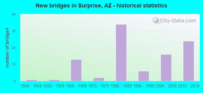
- New bridges - historical statistics
- 11940-1949
- 11950-1959
- 131960-1969
- 21970-1979
- 341980-1989
- 61990-1999
- 162000-2009
- 242010-2019
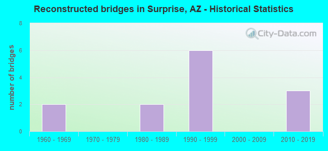
- Reconstructed bridges - Historical Statistics
- 21960-1969
- 01970-1979
- 21980-1989
- 61990-1999
- 02000-2009
- 32010-2019

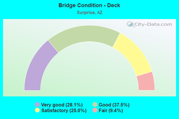
- Bridge Condition - Deck
- 28.1%Very good
- 37.5%Good
- 25.0%Satisfactory
- 9.4%Fair
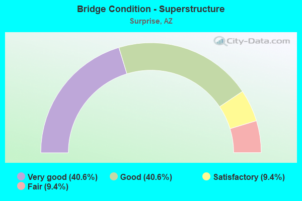
- Bridge Condition - Superstructure
- 40.6%Very good
- 40.6%Good
- 9.4%Satisfactory
- 9.4%Fair
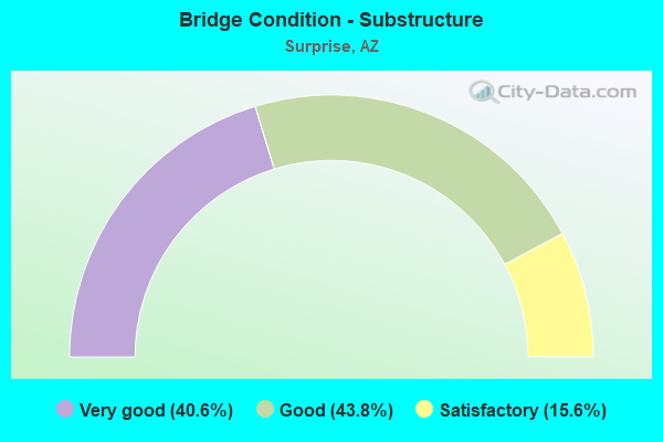
- Bridge Condition - Substructure
- 40.6%Very good
- 43.8%Good
- 15.6%Satisfactory
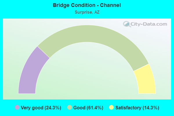
- Bridge Condition - Channel
- 24.3%Very good
- 61.4%Good
- 14.3%Satisfactory
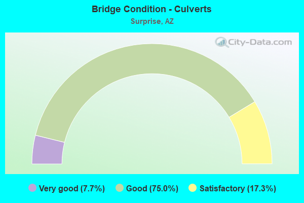
- Bridge Condition - Culverts
- 7.7%Very good
- 75.0%Good
- 17.3%Satisfactory
Find on map >> Show street view
Structure Number: 7691, Location: 19.1 mi N/ McDowell Rd (Lat: 33.660583, Lng: -112.584064), Route carried "on" structure: County highway , Year Built: 1989, Status: Open, Structure Length: 1.52m (4.99ft), Average Daily Traffic: 6,392 (year 2017), Truck Traffic: 10%, Average Future Daily Traffic: 6,402 (year 2037), Design Load: HS 20, Features Intersected: Wash, Facility Carried by Structure: Sun Valley Pkwy-70
Minimum Vertical Clearance: 30+ m (98+ ft), Kilometerpoint: 0.000, Lanes on structure: 4, Owner: County Highway Agency, Approaching Roadway Width: 23.2m (76.1ft), Skew: 23 degrees, Material/Design: Concrete continuous, Design/Construction: Culvert, Number Of Spans In Main Unit: 4, Length of Maximum Span: 3.7m (12.1ft)
Condition: Channel: Good, Culverts: Satisfactory, Operating Rating: 53.3 metric tons, Method Used To Determine Operating Rating: Load Factor (LF), Inventory Rating: 31.9 metric tons, Method Used To Determine Inventory Rating: Load Factor (LF), Structural Evaluation: Equal to present minimum criteria, Waterway Adequacy: Equal to present minimum criteria, Approach Roadway Alignment: Equal to present desirable criteria, Designated Inspection Frequency: Every 48 months, Inspection Date: December 2018
Find on map >> Show street view
Structure Number: 7692, Location: 19.3 mi N/ McDowell Rd (Lat: 33.660586, Lng: -112.580611), Route carried "on" structure: County highway , Year Built: 1989, Status: Open, Structure Length: 1.55m (5.09ft), Average Daily Traffic: 6,392 (year 2017), Truck Traffic: 10%, Average Future Daily Traffic: 6,402 (year 2037), Design Load: HS 20, Features Intersected: Wash, Facility Carried by Structure: Sun Valley Pkwy-72
Minimum Vertical Clearance: 30+ m (98+ ft), Kilometerpoint: 0.000, Lanes on structure: 4, Owner: County Highway Agency, Approaching Roadway Width: 23.2m (76.1ft), Skew: 23 degrees, Material/Design: Concrete continuous, Design/Construction: Culvert, Number Of Spans In Main Unit: 4, Length of Maximum Span: 3.7m (12.1ft)
Condition: Channel: Good, Culverts: Good, Operating Rating: 61.7 metric tons, Method Used To Determine Operating Rating: Load Factor (LF), Inventory Rating: 36.9 metric tons, Method Used To Determine Inventory Rating: Load Factor (LF), Structural Evaluation: Better than present minimum criteria, Waterway Adequacy: Better than present minimum criteria, Approach Roadway Alignment: Equal to present desirable criteria, Designated Inspection Frequency: Every 48 months, Inspection Date: December 2018
Find on map >> Show street view
Structure Number: 7693, Location: 19.6 mi N/ McDowell Rd (Lat: 33.660594, Lng: -112.574847), Route carried "on" structure: County highway , Year Built: 1989, Status: Open, Structure Length: 2.41m (7.91ft), Average Daily Traffic: 6,392 (year 2017), Truck Traffic: 10%, Average Future Daily Traffic: 6,402 (year 2037), Design Load: HS 20, Features Intersected: Wash, Facility Carried by Structure: Sun Valley Pkwy-74
Minimum Vertical Clearance: 30+ m (98+ ft), Kilometerpoint: 0.000, Lanes on structure: 4, Owner: County Highway Agency, Approaching Roadway Width: 23.2m (76.1ft), Skew: 21 degrees, Material/Design: Concrete continuous, Design/Construction: Culvert, Number Of Spans In Main Unit: 6, Length of Maximum Span: 4.0m (13.1ft)
Condition: Channel: Good, Culverts: Good, Operating Rating: 64.8 metric tons, Method Used To Determine Operating Rating: Load Factor (LF), Inventory Rating: 38.8 metric tons, Method Used To Determine Inventory Rating: Load Factor (LF), Structural Evaluation: Better than present minimum criteria, Waterway Adequacy: Equal to present minimum criteria, Approach Roadway Alignment: Equal to present desirable criteria, Designated Inspection Frequency: Every 48 months, Inspection Date: December 2018
Find on map >> Show street view
Structure Number: 7694, Location: 19.7 mi N/ McDowell Rd (Lat: 33.660603, Lng: -112.573314), Route carried "on" structure: County highway , Year Built: 1989, Status: Open, Structure Length: 2.65m (8.69ft), Average Daily Traffic: 6,392 (year 2017), Truck Traffic: 10%, Average Future Daily Traffic: 6,402 (year 2037), Design Load: HS 20, Features Intersected: Wash, Facility Carried by Structure: Sun Valley Pkwy-75
Minimum Vertical Clearance: 30+ m (98+ ft), Kilometerpoint: 0.000, Lanes on structure: 4, Owner: County Highway Agency, Approaching Roadway Width: 23.2m (76.1ft), Skew: 22 degrees, Material/Design: Concrete continuous, Design/Construction: Culvert, Number Of Spans In Main Unit: 6, Length of Maximum Span: 4.3m (14.1ft)
Condition: Channel: Good, Culverts: Good, Inventory Rating: 70.7 metric tons, Method Used To Determine Inventory Rating: Load Factor (LF), Structural Evaluation: Better than present minimum criteria, Waterway Adequacy: Equal to present minimum criteria, Approach Roadway Alignment: Equal to present desirable criteria, Designated Inspection Frequency: Every 48 months, Inspection Date: December 2018
Find on map >> Show street view
Structure Number: 7695, Location: 19.8 mi N McDowell Rd (Lat: 33.660603, Lng: -112.571958), Route carried "on" structure: County highway , Year Built: 1989, Status: Open, Structure Length: 2.01m (6.59ft), Average Daily Traffic: 6,392 (year 2017), Truck Traffic: 10%, Average Future Daily Traffic: 6,402 (year 2037), Design Load: HS 20, Features Intersected: Wash, Facility Carried by Structure: Sun Valley Pkwy-76
Minimum Vertical Clearance: 30+ m (98+ ft), Kilometerpoint: 0.000, Lanes on structure: 4, Owner: County Highway Agency, Approaching Roadway Width: 23.2m (76.1ft), Skew: 20 degrees, Material/Design: Concrete continuous, Design/Construction: Culvert, Number Of Spans In Main Unit: 5, Length of Maximum Span: 3.7m (12.1ft)
Condition: Channel: Good, Culverts: Good, Operating Rating: 88.3 metric tons, Method Used To Determine Operating Rating: Load Factor (LF), Inventory Rating: 52.9 metric tons, Method Used To Determine Inventory Rating: Load Factor (LF), Structural Evaluation: Better than present minimum criteria, Waterway Adequacy: Better than present minimum criteria, Approach Roadway Alignment: Equal to present desirable criteria, Designated Inspection Frequency: Every 48 months, Inspection Date: December 2018
Find on map >> Show street view
Structure Number: 7696, Location: 20.4 mi N/ McDowell Rd (Lat: 33.660619, Lng: -112.560275), Route carried "on" structure: County highway , Year Built: 1989, Status: Open, Structure Length: 0.82m (2.69ft), Average Daily Traffic: 6,392 (year 2017), Truck Traffic: 10%, Average Future Daily Traffic: 6,402 (year 2037), Design Load: HS 20, Features Intersected: Wash, Facility Carried by Structure: Sun Valley Pkwy-78
Minimum Vertical Clearance: 30+ m (98+ ft), Kilometerpoint: 0.000, Lanes on structure: 4, Owner: County Highway Agency, Approaching Roadway Width: 23.2m (76.1ft), Skew: 21 degrees, Material/Design: Concrete continuous, Design/Construction: Culvert, Number Of Spans In Main Unit: 3, Length of Maximum Span: 2.7m (8.9ft)
Condition: Channel: Good, Culverts: Good, Operating Rating: 93.1 metric tons, Method Used To Determine Operating Rating: Load Factor (LF), Inventory Rating: 55.7 metric tons, Method Used To Determine Inventory Rating: Load Factor (LF), Structural Evaluation: Better than present minimum criteria, Waterway Adequacy: Equal to present minimum criteria, Approach Roadway Alignment: Equal to present desirable criteria, Designated Inspection Frequency: Every 48 months, Inspection Date: December 2018
Find on map >> Show street view
Structure Number: 7697, Location: 21.4 mi N/ McDowell Rd (Lat: 33.660647, Lng: -112.543450), Route carried "on" structure: County highway , Year Built: 1989, Status: Open, Structure Length: 2.41m (7.91ft), Average Daily Traffic: 6,392 (year 2017), Truck Traffic: 10%, Average Future Daily Traffic: 6,402 (year 2037), Design Load: HS 20, Features Intersected: Wash, Facility Carried by Structure: Sun Valley Pkwy-79
Minimum Vertical Clearance: 30+ m (98+ ft), Kilometerpoint: 0.000, Lanes on structure: 4, Owner: County Highway Agency, Approaching Roadway Width: 23.2m (76.1ft), Skew: 21 degrees, Material/Design: Concrete continuous, Design/Construction: Culvert, Number Of Spans In Main Unit: 6, Length of Maximum Span: 4.0m (13.1ft)
Condition: Channel: Good, Culverts: Satisfactory, Inventory Rating: 70.7 metric tons, Method Used To Determine Inventory Rating: Load Factor (LF), Structural Evaluation: Equal to present minimum criteria, Waterway Adequacy: Equal to present minimum criteria, Approach Roadway Alignment: Equal to present desirable criteria, Designated Inspection Frequency: Every 48 months, Inspection Date: December 2018
Find on map >> Show street view
Structure Number: 7698, Location: 21.6 mi N/ McDowell Rd (Lat: 33.660658, Lng: -112.540194), Route carried "on" structure: County highway , Year Built: 1989, Status: Open, Structure Length: 2.83m (9.28ft), Average Daily Traffic: 6,392 (year 2017), Truck Traffic: 10%, Average Future Daily Traffic: 6,402 (year 2037), Design Load: HS 20, Features Intersected: Wash, Facility Carried by Structure: Sun Valley Pkwy-80
Minimum Vertical Clearance: 30+ m (98+ ft), Kilometerpoint: 0.000, Lanes on structure: 4, Owner: County Highway Agency, Approaching Roadway Width: 23.2m (76.1ft), Skew: 23 degrees, Material/Design: Concrete continuous, Design/Construction: Culvert, Number Of Spans In Main Unit: 6, Length of Maximum Span: 4.6m (15.1ft)
Condition: Channel: Good, Culverts: Good, Operating Rating: 65.3 metric tons, Method Used To Determine Operating Rating: Load Factor (LF), Inventory Rating: 38.0 metric tons, Method Used To Determine Inventory Rating: Load Factor (LF), Structural Evaluation: Better than present minimum criteria, Waterway Adequacy: Equal to present minimum criteria, Approach Roadway Alignment: Equal to present desirable criteria, Designated Inspection Frequency: Every 48 months, Inspection Date: December 2018
Find on map >> Show street view
Structure Number: 7699, Location: 22.1 mi N/ McDowell Rd (Lat: 33.660692, Lng: -112.530606), Route carried "on" structure: County highway , Year Built: 1989, Status: Open, Structure Length: 1.25m (4.10ft), Average Daily Traffic: 6,392 (year 2017), Truck Traffic: 10%, Average Future Daily Traffic: 6,402 (year 2037), Design Load: HS 20, Features Intersected: Wash, Facility Carried by Structure: Sun Valley Pkwy-81
Minimum Vertical Clearance: 30+ m (98+ ft), Kilometerpoint: 0.000, Lanes on structure: 4, Owner: County Highway Agency, Approaching Roadway Width: 23.2m (76.1ft), Skew: 25 degrees, Material/Design: Concrete continuous, Design/Construction: Culvert, Number Of Spans In Main Unit: 3, Length of Maximum Span: 4.0m (13.1ft)
Condition: Channel: Good, Culverts: Good, Operating Rating: 93.1 metric tons, Method Used To Determine Operating Rating: Load Factor (LF), Inventory Rating: 55.7 metric tons, Method Used To Determine Inventory Rating: Load Factor (LF), Structural Evaluation: Better than present minimum criteria, Waterway Adequacy: Equal to present minimum criteria, Approach Roadway Alignment: Equal to present desirable criteria, Designated Inspection Frequency: Every 48 months, Inspection Date: December 2018
Find on map >> Show street view
Structure Number: 7702, Location: 22.9 mi N/ McDowell Rd (Lat: 33.658692, Lng: -112.516983), Route carried "on" structure: County highway , Year Built: 1989, Status: Open, Structure Length: 1.10m (3.61ft), Average Daily Traffic: 6,392 (year 2017), Truck Traffic: 10%, Average Future Daily Traffic: 6,402 (year 2037), Design Load: HS 20, Features Intersected: Wash, Facility Carried by Structure: Sun Valley Pkwy-84
Minimum Vertical Clearance: 30+ m (98+ ft), Kilometerpoint: 0.000, Lanes on structure: 4, Owner: County Highway Agency, Approaching Roadway Width: 23.2m (76.1ft), Skew: 21 degrees, Material/Design: Concrete continuous, Design/Construction: Culvert, Number Of Spans In Main Unit: 4, Length of Maximum Span: 2.7m (8.9ft)
Condition: Channel: Good, Culverts: Good, Operating Rating: 92.8 metric tons, Method Used To Determine Operating Rating: Load Factor (LF), Inventory Rating: 55.6 metric tons, Method Used To Determine Inventory Rating: Load Factor (LF), Structural Evaluation: Better than present minimum criteria, Waterway Adequacy: Better than present minimum criteria, Approach Roadway Alignment: Equal to present minimum criteria, Designated Inspection Frequency: Every 48 months, Inspection Date: December 2018
Find on map >> Show street view
Structure Number: 7703, Location: 23.4 mi N/ McDowell Rd (Lat: 33.655800, Lng: -112.509544), Route carried "on" structure: County highway , Year Built: 1989, Status: Open, Structure Length: 1.43m (4.69ft), Average Daily Traffic: 6,392 (year 2017), Truck Traffic: 10%, Average Future Daily Traffic: 6,402 (year 2037), Design Load: HS 20, Features Intersected: Wash, Facility Carried by Structure: Sun Valley Pkwy-85
Minimum Vertical Clearance: 30+ m (98+ ft), Kilometerpoint: 0.000, Lanes on structure: 4, Owner: County Highway Agency, Approaching Roadway Width: 23.2m (76.1ft), Skew: 22 degrees, Material/Design: Concrete continuous, Design/Construction: Culvert, Number Of Spans In Main Unit: 4, Length of Maximum Span: 3.4m (11.2ft)
Condition: Channel: Good, Culverts: Good, Operating Rating: 53.3 metric tons, Method Used To Determine Operating Rating: Load Factor (LF), Inventory Rating: 31.9 metric tons, Method Used To Determine Inventory Rating: Load Factor (LF), Structural Evaluation: Better than present minimum criteria, Waterway Adequacy: Better than present minimum criteria, Approach Roadway Alignment: Equal to present minimum criteria, Designated Inspection Frequency: Every 48 months, Inspection Date: December 2018
Find on map >> Show street view
Structure Number: 7704, Location: 24.1 mi N/ McDowell Rd (Lat: 33.649383, Lng: -112.499853), Route carried "on" structure: County highway , Year Built: 1989, Status: Open, Structure Length: 0.67m (2.20ft), Average Daily Traffic: 6,392 (year 2017), Truck Traffic: 10%, Average Future Daily Traffic: 6,402 (year 2037), Design Load: HS 20, Features Intersected: Wash, Facility Carried by Structure: Sun Valley Pkwy-87
Minimum Vertical Clearance: 30+ m (98+ ft), Kilometerpoint: 0.000, Lanes on structure: 4, Owner: County Highway Agency, Approaching Roadway Width: 23.2m (76.1ft), Skew: 20 degrees, Material/Design: Concrete continuous, Design/Construction: Culvert, Number Of Spans In Main Unit: 2, Length of Maximum Span: 3.0m (9.8ft)
Condition: Channel: Good, Culverts: Satisfactory, Operating Rating: 87.0 metric tons, Method Used To Determine Operating Rating: Load Factor (LF), Inventory Rating: 52.1 metric tons, Method Used To Determine Inventory Rating: Load Factor (LF), Structural Evaluation: Equal to present minimum criteria, Waterway Adequacy: Better than present minimum criteria, Approach Roadway Alignment: Equal to present desirable criteria, Designated Inspection Frequency: Every 48 months, Inspection Date: December 2018
Find on map >> Show street view
Structure Number: 7705, Location: 24.2 mi N/ McDowell Rd (Lat: 33.648372, Lng: -112.498567), Route carried "on" structure: County highway , Year Built: 1989, Status: Open, Structure Length: 1.22m (4.00ft), Average Daily Traffic: 6,392 (year 2017), Truck Traffic: 10%, Average Future Daily Traffic: 6,402 (year 2037), Design Load: HS 20, Features Intersected: Wash, Facility Carried by Structure: Sun Valley Pkwy-88
Minimum Vertical Clearance: 30+ m (98+ ft), Kilometerpoint: 0.000, Lanes on structure: 4, Owner: County Highway Agency, Approaching Roadway Width: 23.2m (76.1ft), Skew: 23 degrees, Material/Design: Concrete continuous, Design/Construction: Culvert, Number Of Spans In Main Unit: 3, Length of Maximum Span: 4.0m (13.1ft)
Condition: Channel: Good, Culverts: Satisfactory, Operating Rating: 95.2 metric tons, Method Used To Determine Operating Rating: Load Factor (LF), Inventory Rating: 57.0 metric tons, Method Used To Determine Inventory Rating: Load Factor (LF), Structural Evaluation: Equal to present minimum criteria, Waterway Adequacy: Equal to present minimum criteria, Approach Roadway Alignment: Equal to present desirable criteria, Designated Inspection Frequency: Every 48 months, Inspection Date: December 2018
Find on map >> Show street view
Structure Number: 7855, Location: 1.35 mi SW of Grand Ave (Lat: 33.682100, Lng: -112.442100), Route carried "on" structure: City street , Year Built: 1988, Status: Open, Structure Length: 5.46m (17.91ft), Average Daily Traffic: 1,621 (year 2020), Truck Traffic: 40%, Average Future Daily Traffic: 1,631 (year 2040), Design Load: HS 20, Features Intersected: Wash, Facility Carried by Structure: Deer Valley Road
Minimum Vertical Clearance: 30+ m (98+ ft), Kilometerpoint: 0.000, Lanes on structure: 2, Owner: Town or Township Highway Agency, Approaching Roadway Width: 14.6m (47.9ft), Skew: 4 degrees, Material/Design: Concrete continuous, Design/Construction: Slab, Number Of Spans In Main Unit: 3, Length of Maximum Span: 20.4m (66.9ft), Curb-To-Curb Width: 14.7m (48.2ft), Out-to-Out Width: 15.7m (51.5ft)
Condition: Deck: Fair, Superstructure: Fair, Substructure: Satisfactory, Channel: Satisfactory, Operating Rating: 36.3 metric tons, Method Used To Determine Operating Rating: Load Factor (LF), Inventory Rating: 21.8 metric tons, Method Used To Determine Inventory Rating: Load Factor (LF), Structural Evaluation: Somewhat better than minimum adequacy, Deck Geometry: Superior to present desirable criteria, Waterway Adequacy: Equal to present desirable criteria, Approach Roadway Alignment: Equal to present desirable criteria, Length Of Structure Improvement: 5.46m (17.91ft), Designated Inspection Frequency: Every 24 months, Inspection Date: July 2021, Deck Structure Type: Concrete Cast-file-Place, Wearing Surface/Protective System: Wearing Surface: Bituminous
Find on map >> Show street view
Structure Number: 7856, Location: 0.15 mi SW Jct Grand Ave (Lat: 33.694000, Lng: -112.425200), Route carried "on" structure: City street , Year Built: 1988, Status: Open, Structure Length: 0.98m (3.22ft), Average Daily Traffic: 1,621 (year 2020), Truck Traffic: 7%, Average Future Daily Traffic: 1,631 (year 2040), Design Load: HS 20, Features Intersected: Wash, Facility Carried by Structure: Deer Valley Road
Minimum Vertical Clearance: 30+ m (98+ ft), Kilometerpoint: 0.000, Lanes on structure: 2, Owner: Town or Township Highway Agency, Approaching Roadway Width: 8.5m (27.9ft), Material/Design: Concrete continuous, Design/Construction: Culvert, Number Of Spans In Main Unit: 3, Length of Maximum Span: 3.0m (9.8ft)
Condition: Channel: Good, Culverts: Very good, Operating Rating: 65.3 metric tons, Method Used To Determine Operating Rating: Load Factor (LF), Inventory Rating: 39.0 metric tons, Method Used To Determine Inventory Rating: Load Factor (LF), Structural Evaluation: Equal to present desirable criteria, Waterway Adequacy: Better than present minimum criteria, Approach Roadway Alignment: Equal to present desirable criteria, Designated Inspection Frequency: Every 48 months, Inspection Date: July 2021
Find on map >> Show street view
Structure Number: 7858, Location: 0.25 mi SW Jct Grand Ave (Lat: 33.693500, Lng: -112.425800), Route carried "on" structure: City street , Year Built: 1988, Status: Open, Structure Length: 0.98m (3.22ft), Average Daily Traffic: 1,621 (year 2020), Truck Traffic: 70%, Average Future Daily Traffic: 1,631 (year 2040), Design Load: HS 20, Features Intersected: Wash, Facility Carried by Structure: Deer Valley Road
Minimum Vertical Clearance: 30+ m (98+ ft), Kilometerpoint: 0.000, Lanes on structure: 2, Owner: Town or Township Highway Agency, Approaching Roadway Width: 11.6m (38.1ft), Material/Design: Concrete continuous, Design/Construction: Culvert, Number Of Spans In Main Unit: 3, Length of Maximum Span: 3.0m (9.8ft)
Condition: Channel: Good, Culverts: Good, Operating Rating: 65.3 metric tons, Method Used To Determine Operating Rating: Load Factor (LF), Inventory Rating: 39.0 metric tons, Method Used To Determine Inventory Rating: Load Factor (LF), Structural Evaluation: Better than present minimum criteria, Waterway Adequacy: Better than present minimum criteria, Approach Roadway Alignment: Equal to present desirable criteria, Designated Inspection Frequency: Every 48 months, Inspection Date: July 2021
Find on map >> Show street view
Structure Number: 7859, Location: 0.30 mi SW Jct Grand Ave (Lat: 33.692300, Lng: -112.427100), Route carried "on" structure: City street , Year Built: 1988, Status: Open, Structure Length: 0.98m (3.22ft), Average Daily Traffic: 1,621 (year 2020), Truck Traffic: 70%, Average Future Daily Traffic: 1,631 (year 2040), Design Load: HS 20, Features Intersected: Wash, Facility Carried by Structure: Deer Valley Road
Minimum Vertical Clearance: 30+ m (98+ ft), Kilometerpoint: 0.000, Lanes on structure: 2, Owner: Town or Township Highway Agency, Approaching Roadway Width: 11.6m (38.1ft), Material/Design: Concrete continuous, Design/Construction: Culvert, Number Of Spans In Main Unit: 3, Length of Maximum Span: 3.0m (9.8ft)
Condition: Channel: Good, Culverts: Very good, Operating Rating: 65.3 metric tons, Method Used To Determine Operating Rating: Load Factor (LF), Inventory Rating: 39.0 metric tons, Method Used To Determine Inventory Rating: Load Factor (LF), Structural Evaluation: Equal to present desirable criteria, Waterway Adequacy: Better than present minimum criteria, Approach Roadway Alignment: Equal to present desirable criteria, Designated Inspection Frequency: Every 48 months, Inspection Date: July 2021
Find on map >> Show street view
Structure Number: 786, Location: 1.15 mi SW Jct Grand Ave (Lat: 33.682500, Lng: -112.438500), Route carried "on" structure: City street , Year Built: 1987, Status: Open, Structure Length: 0.91m (2.99ft), Average Daily Traffic: 1,621 (year 2020), Truck Traffic: 70%, Average Future Daily Traffic: 1,631 (year 2040), Design Load: HS 20, Features Intersected: Wash, Facility Carried by Structure: Deer Valley Road
Minimum Vertical Clearance: 30+ m (98+ ft), Kilometerpoint: 0.000, Lanes on structure: 2, Owner: Town or Township Highway Agency, Approaching Roadway Width: 7.9m (25.9ft), Skew: 4 degrees, Material/Design: Concrete continuous, Design/Construction: Culvert, Number Of Spans In Main Unit: 2, Length of Maximum Span: 3.0m (9.8ft)
Condition: Channel: Very good, Culverts: Good, Operating Rating: 89.8 metric tons, Method Used To Determine Operating Rating: Load Factor (LF), Inventory Rating: 89.8 metric tons, Method Used To Determine Inventory Rating: Load Factor (LF), Structural Evaluation: Better than present minimum criteria, Waterway Adequacy: Equal to present desirable criteria, Approach Roadway Alignment: Equal to present desirable criteria, Designated Inspection Frequency: Every 48 months, Inspection Date: July 2021
Find on map >> Show street view
Structure Number: 8569, Location: 1.7 mi W/ Grand Ave (Lat: 33.738667, Lng: -112.509028), Route carried "on" structure: County highway , Year Built: 1981, Status: Open, Structure Length: 3.62m (11.88ft), Average Daily Traffic: 5,320 (year 2019), Truck Traffic: 10%, Average Future Daily Traffic: 5,330 (year 2039), Design Load: HS 20, Features Intersected: CAP Canal, Facility Carried by Structure: Patton Rd
Minimum Vertical Clearance: 30+ m (98+ ft), Kilometerpoint: 0.000, Lanes on structure: 2, Owner: County Highway Agency, Approaching Roadway Width: 8.5m (27.9ft), Skew: 4 degrees, Material/Design: Prestressed concrete, Design/Construction: Stringer/Multi-beam, Number Of Spans In Main Unit: 2, Length of Maximum Span: 17.4m (57.1ft), Curb-To-Curb Width: 15.2m (49.9ft), Out-to-Out Width: 16.1m (52.8ft)
Condition: Deck: Good, Superstructure: Satisfactory, Substructure: Satisfactory, Channel: Very good, Operating Rating: 47.4 metric tons, Method Used To Determine Operating Rating: Load Factor (LF), Inventory Rating: 28.3 metric tons, Method Used To Determine Inventory Rating: Load Factor (LF), Structural Evaluation: Equal to present minimum criteria, Deck Geometry: Superior to present desirable criteria, Waterway Adequacy: Equal to present desirable criteria, Approach Roadway Alignment: Equal to present desirable criteria, Designated Inspection Frequency: Every 24 months, Inspection Date: Febuary 2020, Deck Structure Type: Concrete Cast-file-Place, Wearing Surface/Protective System: Wearing Surface: Epoxy Overlay
Find on map >> Show street view
Structure Number: 8571, Location: 5 mi N/ US 60_Grand Ave (Lat: 33.758611, Lng: -112.412261), Route carried "on" structure: County highway , Year Built: 1979, Status: Open, Structure Length: 2.69m (8.83ft), Average Daily Traffic: 1,500 (year 2020), Truck Traffic: 2%, Average Future Daily Traffic: 1,510 (year 2040), Design Load: HS 20, Features Intersected: HaydenRhodes CAP Aqueduc, Facility Carried by Structure: 163rd Avenue
Minimum Vertical Clearance: 30+ m (98+ ft), Kilometerpoint: 0.000, Lanes on structure: 2, Owner: County Highway Agency, Approaching Roadway Width: 9.1m (29.9ft), Material/Design: Prestressed concrete, Design/Construction: Stringer/Multi-beam, Number Of Spans In Main Unit: 1, Length of Maximum Span: 26.2m (86.0ft), Curb or Sidewalk Widths: Left: 2.5m (8.2ft), Right: 0.0m, Curb-To-Curb Width: 14.6m (47.9ft), Out-to-Out Width: 18.2m (59.7ft)
Condition: Deck: Good, Superstructure: Good, Substructure: Satisfactory, Channel: Very good, Operating Rating: 61.9 metric tons, Method Used To Determine Operating Rating: Load Factor (LF), Inventory Rating: 33.5 metric tons, Method Used To Determine Inventory Rating: Load Factor (LF), Structural Evaluation: Equal to present minimum criteria, Deck Geometry: Superior to present desirable criteria, Waterway Adequacy: Equal to present desirable criteria, Approach Roadway Alignment: Equal to present minimum criteria, Designated Inspection Frequency: Every 24 months, Inspection Date: Febuary 2020, Deck Structure Type: Concrete Cast-file-Place, Wearing Surface/Protective System: Wearing Surface: Epoxy Overlay
Find on map >> Show street view
Structure Number: 8646, Location: 2.33 mi S of Jomax Road (Lat: 33.690100, Lng: -112.582300), Route carried "on" structure: City street , Year Built: 1981, Status: Open, Structure Length: 2.59m (8.50ft), Average Daily Traffic: 25 (year 2020), Truck Traffic: 10%, Average Future Daily Traffic: 35 (year 2040), Design Load: HS 20, Features Intersected: CAP Canal, Facility Carried by Structure: 243rd Avenue
Minimum Vertical Clearance: 30+ m (98+ ft), Kilometerpoint: 0.000, Lanes on structure: 2, Owner: Town or Township Highway Agency, Approaching Roadway Width: 11.0m (36.1ft), Material/Design: Prestressed concrete, Design/Construction: Stringer/Multi-beam, Number Of Spans In Main Unit: 1, Length of Maximum Span: 25.6m (84.0ft), Curb-To-Curb Width: 11.0m (36.1ft), Out-to-Out Width: 11.8m (38.7ft)
Condition: Deck: Satisfactory, Superstructure: Good, Substructure: Very good, Channel: Very good, Operating Rating: 73.5 metric tons, Method Used To Determine Operating Rating: Load Factor (LF), Inventory Rating: 35.4 metric tons, Method Used To Determine Inventory Rating: Load Factor (LF), Structural Evaluation: Better than present minimum criteria, Deck Geometry: Superior to present desirable criteria, Waterway Adequacy: Equal to present desirable criteria, Approach Roadway Alignment: Better than present minimum criteria, Designated Inspection Frequency: Every 24 months, Inspection Date: Febuary 2020, Deck Structure Type: Concrete Cast-file-Place, Wearing Surface/Protective System: Wearing Surface: Monolithic Concrete
Find on map >> Show street view
Structure Number: 8647, Location: 0.96 mi S of Patton Road (Lat: 33.724400, Lng: -112.533500), Route carried "on" structure: City street , Year Built: 1981, Status: Open, Structure Length: 2.59m (8.50ft), Average Daily Traffic: 25 (year 2020), Truck Traffic: 10%, Average Future Daily Traffic: 35 (year 2040), Design Load: HS 20, Features Intersected: CAP Canal, Facility Carried by Structure: Crozier Rd
Minimum Vertical Clearance: 30+ m (98+ ft), Kilometerpoint: 0.000, Lanes on structure: 2, Owner: Town or Township Highway Agency, Approaching Roadway Width: 15.8m (51.8ft), Material/Design: Prestressed concrete, Design/Construction: Stringer/Multi-beam, Number Of Spans In Main Unit: 1, Length of Maximum Span: 25.6m (84.0ft), Curb-To-Curb Width: 15.2m (49.9ft), Out-to-Out Width: 16.1m (52.8ft)
Condition: Deck: Satisfactory, Superstructure: Good, Substructure: Satisfactory, Channel: Good, Operating Rating: 75.3 metric tons, Method Used To Determine Operating Rating: Load Factor (LF), Inventory Rating: 33.6 metric tons, Method Used To Determine Inventory Rating: Load Factor (LF), Structural Evaluation: Equal to present minimum criteria, Deck Geometry: Superior to present desirable criteria, Waterway Adequacy: Equal to present desirable criteria, Approach Roadway Alignment: Equal to present minimum criteria, Designated Inspection Frequency: Every 24 months, Inspection Date: Febuary 2020, Deck Structure Type: Concrete Cast-file-Place, Wearing Surface/Protective System: Wearing Surface: Monolithic Concrete
Find on map >> Show street view
Structure Number: 8858, Location: 0.27 mi W of 183rd Avenue (Lat: 33.624100, Lng: -112.458500), Route carried "on" structure: City street , Year Built: 1986, Status: Open, Structure Length: 1.19m (3.90ft), Average Daily Traffic: 25 (year 2020), Truck Traffic: 10%, Average Future Daily Traffic: 35 (year 2040), Design Load: HS 20, Features Intersected: Beardsley Canal, Facility Carried by Structure: Greenway Rd
Minimum Vertical Clearance: 30+ m (98+ ft), Kilometerpoint: 0.000, Lanes on structure: 2, Owner: Town or Township Highway Agency, Approaching Roadway Width: 14.9m (48.9ft), Material/Design: Prestressed concrete, Design/Construction: Box Beam or Girders - Multiple, Number Of Spans In Main Unit: 1, Length of Maximum Span: 11.6m (38.1ft), Curb-To-Curb Width: 14.9m (48.9ft), Out-to-Out Width: 15.8m (51.8ft)
Condition: Deck: Satisfactory, Superstructure: Good, Substructure: Good, Channel: Satisfactory, Operating Rating: 37.2 metric tons, Method Used To Determine Operating Rating: Field evaluation and documented engineering judgment, Inventory Rating: 21.8 metric tons, Method Used To Determine Inventory Rating: Field evaluation and documented engineering judgment, Structural Evaluation: Equal to present minimum criteria, Deck Geometry: Superior to present desirable criteria, Waterway Adequacy: Equal to present desirable criteria, Approach Roadway Alignment: Equal to present desirable criteria, Designated Inspection Frequency: Every 24 months, Inspection Date: March 2020, Deck Structure Type: Other, Wearing Surface/Protective System: Wearing Surface: Bituminous
Find on map >> Show street view
Structure Number: 8885, Location: at Jomax Road (Lat: 33.724700, Lng: -112.412300), Route carried "on" structure: City street , Year Built: 1986, Status: Open, Structure Length: 1.89m (6.20ft), Average Daily Traffic: 6,619 (year 2017), Truck Traffic: 5%, Average Future Daily Traffic: 6,629 (year 2037), Design Load: HS 20, Features Intersected: Wash, Facility Carried by Structure: 163 Avenue
Minimum Vertical Clearance: 30+ m (98+ ft), Kilometerpoint: 0.000, Lanes on structure: 2, Owner: Town or Township Highway Agency, Approaching Roadway Width: 7.9m (25.9ft), Skew: 4 degrees, Material/Design: Concrete continuous, Design/Construction: Culvert, Number Of Spans In Main Unit: 5, Length of Maximum Span: 2.4m (7.9ft)
Condition: Channel: Satisfactory, Culverts: Good, Operating Rating: 74.4 metric tons, Method Used To Determine Operating Rating: Load Factor (LF), Inventory Rating: 44.5 metric tons, Method Used To Determine Inventory Rating: Load Factor (LF), Structural Evaluation: Better than present minimum criteria, Waterway Adequacy: Better than present minimum criteria, Approach Roadway Alignment: Better than present minimum criteria, Designated Inspection Frequency: Every 48 months, Inspection Date: July 2021
Find on map >> Show street view
Structure Number: 9127, Location: 0.3 mi E Agua Fria River (Lat: 33.638700, Lng: -112.313400), Route carried "on" structure: City street , Year Built: 1965, Year Reconstructed: 1980, Status: Open, Structure Length: 1.01m (3.31ft), Average Daily Traffic: 46,256 (year 2020), Truck Traffic: 10%, Average Future Daily Traffic: 46,266 (year 2040), Design Load: HS 20, Features Intersected: Truck Overpass, Facility Carried by Structure: Bell Road
Minimum Vertical Clearance: 30+ m (98+ ft), Kilometerpoint: 0.000, Lanes on structure: 6, Lanes under structure: 6, Owner: Town or Township Highway Agency, Approaching Roadway Width: 21.9m (71.9ft), Skew: 10 degrees, Material/Design: Concrete continuous, Design/Construction: Culvert, Number Of Spans In Main Unit: 2, Length of Maximum Span: 4.9m (16.1ft), Curb or Sidewalk Widths: Left: 0.0m, Right: 1.5m (4.9ft), Curb-To-Curb Width: 23.8m (78.1ft), Out-to-Out Width: 32.3m (106.0ft)
Condition: Culverts: Satisfactory, Operating Rating: 60.8 metric tons, Method Used To Determine Operating Rating: Load Factor (LF), Inventory Rating: 36.3 metric tons, Method Used To Determine Inventory Rating: Load Factor (LF), Structural Evaluation: Equal to present minimum criteria, Deck Geometry: Somewhat better than minimum adequacy, Underclear: High priority of replacement, Approach Roadway Alignment: Equal to present desirable criteria, Length Of Structure Improvement: 1.83m (6.00ft), Designated Inspection Frequency: Every 48 months, Inspection Date: July 2021, Total Project Cost: $1,000 ( Estimate for 2021), Deck Structure Type: Concrete Cast-file-Place, Wearing Surface/Protective System: Wearing Surface: Bituminous
Find on map >> Show street view
Structure Number: 9691, Location: 1.25 mi E Dysart Rd (Lat: 33.638889, Lng: -112.318056), Route carried "on" structure: City street , Year Built: 1981, Status: Open, Structure Length: 33.83m (110.99ft), Average Daily Traffic: 43,506 (year 2020), Truck Traffic: 10%, Average Future Daily Traffic: 43,516 (year 2040), Design Load: HS 20, Features Intersected: Agua Fria River, Facility Carried by Structure: Bell Road
Minimum Vertical Clearance: 30+ m (98+ ft), Kilometerpoint: 0.000, Lanes on structure: 6, Owner: Town or Township Highway Agency, Approaching Roadway Width: 29.3m (96.1ft), Skew: 30 degrees, Material/Design: Prestressed concrete continuous, Design/Construction: Stringer/Multi-beam, Number Of Spans In Main Unit: 9, Length of Maximum Span: 37.5m (123.0ft), Curb or Sidewalk Widths: Left: 0.0m, Right: 2.4m (7.9ft), Curb-To-Curb Width: 22.6m (74.1ft), Out-to-Out Width: 26.2m (86.0ft)
Condition: Deck: Satisfactory, Superstructure: Good, Substructure: Good, Channel: Good, Operating Rating: 89.8 metric tons, Method Used To Determine Operating Rating: Load Factor (LF), Inventory Rating: 32.7 metric tons, Method Used To Determine Inventory Rating: Load Factor (LF), Structural Evaluation: Better than present minimum criteria, Deck Geometry: Meets minimum limits, Waterway Adequacy: Equal to present desirable criteria, Approach Roadway Alignment: Equal to present desirable criteria, Length Of Structure Improvement: 35.63m (116.90ft), Designated Inspection Frequency: Every 24 months, Inspection Date: July 2021, Bridge Improvement Cost: $6,000, Roadway Improvement Cost: $1,000, Total Project Cost: $9,000 ( Estimate for 2021), Deck Structure Type: Concrete Cast-file-Place, Wearing Surface/Protective System: Wearing Surface: Bituminous
Find on map >> Show street view
Structure Number: 9735, Location: at 115th Ave (Lat: 33.638700, Lng: -112.307400), Route carried "on" structure: City street , Year Built: 1981, Year Reconstructed: 1992, Status: Open, Structure Length: 0.98m (3.22ft), Average Daily Traffic: 52,747 (year 2020), Truck Traffic: 10%, Average Future Daily Traffic: 52,757 (year 2040), Design Load: HS 20, Features Intersected: Drainage Ditch, Facility Carried by Structure: Bell Rd
Minimum Vertical Clearance: 9.14m (29.99ft), Kilometerpoint: 0.000, Lanes on structure: 7, Owner: Town or Township Highway Agency, Approaching Roadway Width: 25.6m (84.0ft), Skew: 31 degrees, Material/Design: Concrete continuous, Design/Construction: Culvert, Number Of Spans In Main Unit: 3, Length of Maximum Span: 2.7m (8.9ft), Curb or Sidewalk Widths: Left: 1.5m (4.9ft), Right: 0.0m
Condition: Channel: Satisfactory, Culverts: Satisfactory, Operating Rating: 64.4 metric tons, Method Used To Determine Operating Rating: Load Factor (LF), Inventory Rating: 38.1 metric tons, Method Used To Determine Inventory Rating: Load Factor (LF), Structural Evaluation: Equal to present minimum criteria, Waterway Adequacy: Better than present minimum criteria, Approach Roadway Alignment: Equal to present desirable criteria, Designated Inspection Frequency: Every 48 months, Inspection Date: July 2021
Find on map >> Show street view
Structure Number: 10274, Location: 0.25 mi W/ Grand Ave (Lat: 33.724317, Lng: -112.466244), Route carried "on" structure: County highway , Year Built: 1999, Status: Open, Structure Length: 0.98m (3.22ft), Average Daily Traffic: 253 (year 2020), Average Future Daily Traffic: 263 (year 2040), Design Load: HS 20, Features Intersected: Wash, Facility Carried by Structure: Jomax Road
Minimum Vertical Clearance: 30+ m (98+ ft), Kilometerpoint: 0.000, Lanes on structure: 2, Owner: County Highway Agency, Approaching Roadway Width: 8.5m (27.9ft), Material/Design: Concrete continuous, Design/Construction: Culvert, Number Of Spans In Main Unit: 3, Length of Maximum Span: 3.0m (9.8ft)
Condition: Channel: Satisfactory, Culverts: Good, Inventory Rating: 63.5 metric tons, Method Used To Determine Inventory Rating: Load Factor (LF), Structural Evaluation: Better than present minimum criteria, Waterway Adequacy: Equal to present minimum criteria, Approach Roadway Alignment: Equal to present minimum criteria, Designated Inspection Frequency: Every 48 months, Inspection Date: January 2022
Find on map >> Show street view
Structure Number: 10784, Location: 0.18 mi. S/ Jomax Rd (Lat: 33.722081, Lng: -112.351306), Route carried "on" structure: County highway , Year Built: 2007, Status: Open, Structure Length: 0.85m (2.79ft), Average Daily Traffic: 1,000 (year 2020), Average Future Daily Traffic: 1,010 (year 2040), Design Load: HS 20, Features Intersected: Drainage Channel, Facility Carried by Structure: El Granada Blvd
Minimum Vertical Clearance: 30+ m (98+ ft), Kilometerpoint: 0.000, Lanes on structure: 2, Owner: County Highway Agency, Approaching Roadway Width: 14.6m (47.9ft), Skew: 2 degrees, Material/Design: Concrete continuous, Design/Construction: Culvert, Number Of Spans In Main Unit: 3, Length of Maximum Span: 2.7m (8.9ft), Curb or Sidewalk Widths: Left: 1.5m (4.9ft), Right: 1.5m (4.9ft)
Condition: Channel: Good, Culverts: Good, Operating Rating: 66.7 metric tons, Method Used To Determine Operating Rating: Load Factor (LF), Inventory Rating: 39.9 metric tons, Method Used To Determine Inventory Rating: Load Factor (LF), Structural Evaluation: Better than present minimum criteria, Waterway Adequacy: Equal to present desirable criteria, Approach Roadway Alignment: Equal to present minimum criteria, Designated Inspection Frequency: Every 48 months, Inspection Date: January 2020
Find on map >> Show street view
Structure Number: 10785, Location: 0.5 mi. N/HappyValley Rd (Lat: 33.717422, Lng: -112.347722), Route carried "on" structure: County highway , Year Built: 2007, Status: Open, Structure Length: 1.31m (4.30ft), Average Daily Traffic: 1,000 (year 2020), Average Future Daily Traffic: 1,010 (year 2040), Design Load: HS 20, Features Intersected: Drainage Channel, Facility Carried by Structure: El Granada Blvd
Minimum Vertical Clearance: 30+ m (98+ ft), Kilometerpoint: 0.000, Lanes on structure: 2, Owner: County Highway Agency, Approaching Roadway Width: 14.6m (47.9ft), Material/Design: Concrete continuous, Design/Construction: Culvert, Number Of Spans In Main Unit: 4, Length of Maximum Span: 3.0m (9.8ft), Curb or Sidewalk Widths: Left: 1.5m (4.9ft), Right: 1.5m (4.9ft)
Condition: Channel: Very good, Culverts: Good, Structural Evaluation: Better than present minimum criteria, Waterway Adequacy: Equal to present desirable criteria, Approach Roadway Alignment: Equal to present minimum criteria, Designated Inspection Frequency: Every 48 months, Inspection Date: January 2020
Find on map >> Show street view
Structure Number: 10786, Location: 0.5 mi. N/ HappyValley Rd (Lat: 33.717144, Lng: -112.347536), Route carried "on" structure: County highway , Year Built: 2007, Status: Open, Structure Length: 1.98m (6.50ft), Average Daily Traffic: 1,500 (year 2022), Average Future Daily Traffic: 1,510 (year 2042), Design Load: HS 20, Features Intersected: Beardsley Canal, Facility Carried by Structure: El Granada Blvd
Minimum Vertical Clearance: 30+ m (98+ ft), Kilometerpoint: 0.000, Lanes on structure: 2, Owner: County Highway Agency, Approaching Roadway Width: 14.6m (47.9ft), Skew: 1 degrees, Material/Design: Prestressed concrete, Design/Construction: Stringer/Multi-beam, Number Of Spans In Main Unit: 1, Length of Maximum Span: 18.3m (60.0ft), Curb or Sidewalk Widths: Left: 1.8m (5.9ft), Right: 1.8m (5.9ft), Curb-To-Curb Width: 15.5m (50.9ft), Out-to-Out Width: 19.8m (65.0ft)
Condition: Deck: Very good, Superstructure: Good, Substructure: Good, Channel: Very good, Operating Rating: 90.4 metric tons, Method Used To Determine Operating Rating: Load Factor (LF), Inventory Rating: 52.9 metric tons, Method Used To Determine Inventory Rating: Load Factor (LF), Structural Evaluation: Better than present minimum criteria, Deck Geometry: Superior to present desirable criteria, Waterway Adequacy: Equal to present desirable criteria, Approach Roadway Alignment: Equal to present minimum criteria, Designated Inspection Frequency: Every 24 months, Inspection Date: January 2022, Deck Structure Type: Concrete Cast-file-Place, Wearing Surface/Protective System: Wearing Surface: Epoxy Overlay
Find on map >> Show street view
Structure Number: 11327, Location: 0.25 mi. N/Patton Rd (Lat: 33.742728, Lng: -112.559672), Route carried "on" structure: County highway , Year Built: 2013, Status: Open, Structure Length: 0.67m (2.20ft), Average Daily Traffic: 100 (year 2022), Average Future Daily Traffic: 110 (year 2042), Design Load: HS 20, Features Intersected: Drainage Wash, Facility Carried by Structure: 231st Ave
Minimum Vertical Clearance: 30+ m (98+ ft), Kilometerpoint: 0.000, Lanes on structure: 2, Owner: County Highway Agency, Approaching Roadway Width: 7.3m (24.0ft), Skew: 1 degrees, Material/Design: Concrete continuous, Design/Construction: Culvert, Number Of Spans In Main Unit: 2, Length of Maximum Span: 3.0m (9.8ft), Curb-To-Curb Width: 7.9m (25.9ft), Out-to-Out Width: 7.9m (25.9ft)
Condition: Channel: Good, Culverts: Good, Operating Rating: 78.3 metric tons, Method Used To Determine Operating Rating: Load Factor (LF), Inventory Rating: 46.9 metric tons, Method Used To Determine Inventory Rating: Load Factor (LF), Structural Evaluation: Better than present minimum criteria, Deck Geometry: Equal to present minimum criteria, Waterway Adequacy: Equal to present desirable criteria, Approach Roadway Alignment: Equal to present desirable criteria, Designated Inspection Frequency: Every 48 months, Inspection Date: January 2022, Wearing Surface/Protective System: Wearing Surface: Bituminous
Find on map >> Show street view
Structure Number: 11557, Location: 3 mi W of L303 (Lat: 33.709600, Lng: -112.364800), Route carried "on" structure: City street , Year Built: 2018, Status: Open, Structure Length: 1.98m (6.50ft), Average Daily Traffic: 1,000 (year 2020), Truck Traffic: 2%, Average Future Daily Traffic: 1,010 (year 2040), Design Load: HL 93, Features Intersected: Beardsley Canal, Facility Carried by Structure: Happy Valley Rd EB
Minimum Vertical Clearance: 30+ m (98+ ft), Kilometerpoint: 0.000, Lanes on structure: 2, Owner: City or Municipal Highway Agency, Approaching Roadway Width: 11.6m (38.1ft), Skew: 1 degrees, Material/Design: Prestressed concrete, Design/Construction: Stringer/Multi-beam, Number Of Spans In Main Unit: 1, Length of Maximum Span: 18.0m (59.1ft), Curb or Sidewalk Widths: Left: 0.0m, Right: 1.8m (5.9ft), Curb-To-Curb Width: 11.4m (37.4ft), Out-to-Out Width: 14.2m (46.6ft)
Condition: Deck: Very good, Superstructure: Very good, Substructure: Very good, Channel: Very good, Operating Rating: 59.9 metric tons, Method Used To Determine Operating Rating: Load Factor (LF), Inventory Rating: 35.4 metric tons, Method Used To Determine Inventory Rating: Load Factor (LF), Structural Evaluation: Equal to present desirable criteria, Deck Geometry: Equal to present minimum criteria, Waterway Adequacy: Equal to present desirable criteria, Approach Roadway Alignment: Equal to present desirable criteria, Designated Inspection Frequency: Every 24 months, Inspection Date: Febuary 2020, Deck Structure Type: Concrete Cast-file-Place, Wearing Surface/Protective System: Wearing Surface: Monolithic Concrete
Find on map >> Show street view
Structure Number: 11558, Location: 3 mi W of L303 (Lat: 33.709700, Lng: -112.364700), Route carried "on" structure: City street , Year Built: 2018, Status: Open, Structure Length: 1.98m (6.50ft), Average Daily Traffic: 1,000 (year 2020), Truck Traffic: 2%, Average Future Daily Traffic: 1,010 (year 2040), Design Load: HL 93, Features Intersected: Beardsley Canal, Facility Carried by Structure: Happy Valley Rd WB
Minimum Vertical Clearance: 30.45m (99.90ft), Kilometerpoint: 0.000, Lanes on structure: 2, Owner: City or Municipal Highway Agency, Approaching Roadway Width: 11.6m (38.1ft), Skew: 1 degrees, Material/Design: Prestressed concrete, Design/Construction: Stringer/Multi-beam, Number Of Spans In Main Unit: 1, Length of Maximum Span: 18.0m (59.1ft), Curb or Sidewalk Widths: Left: 0.0m, Right: 1.8m (5.9ft), Curb-To-Curb Width: 11.4m (37.4ft), Out-to-Out Width: 14.2m (46.6ft)
Condition: Deck: Very good, Superstructure: Very good, Substructure: Very good, Channel: Very good, Operating Rating: 59.9 metric tons, Method Used To Determine Operating Rating: Load Factor (LF), Inventory Rating: 35.4 metric tons, Method Used To Determine Inventory Rating: Load Factor (LF), Structural Evaluation: Equal to present desirable criteria, Deck Geometry: Equal to present minimum criteria, Waterway Adequacy: Equal to present desirable criteria, Approach Roadway Alignment: Equal to present desirable criteria, Designated Inspection Frequency: Every 24 months, Inspection Date: Febuary 2020, Deck Structure Type: Concrete Cast-file-Place, Wearing Surface/Protective System: Wearing Surface: Monolithic Concrete
Find on map >> Show street view
Structure Number: 11632, Location: W of 137th Ave (Lat: 33.720800, Lng: -112.356800), Route carried "on" structure: County highway , Year Built: 2007, Year Reconstructed: 2016, Status: Open, Structure Length: 0.85m (2.79ft), Average Daily Traffic: 100 (year 2020), Average Future Daily Traffic: 110 (year 2040), Design Load: HS 20, Features Intersected: Wash, Facility Carried by Structure: Paso Trail
Minimum Vertical Clearance: 30+ m (98+ ft), Kilometerpoint: 0.000, Lanes on structure: 2, Owner: County Highway Agency, Approaching Roadway Width: 11.6m (38.1ft), Skew: 1 degrees, Material/Design: Concrete continuous, Design/Construction: Culvert, Number Of Spans In Main Unit: 4, Length of Maximum Span: 2.1m (6.9ft), Curb or Sidewalk Widths: Left: 1.5m (4.9ft), Right: 1.5m (4.9ft)
Condition: Channel: Very good, Culverts: Good, Inventory Rating: 63.5 metric tons, Method Used To Determine Inventory Rating: Load Factor (LF), Structural Evaluation: Better than present minimum criteria, Waterway Adequacy: Equal to present desirable criteria, Approach Roadway Alignment: Equal to present desirable criteria, Designated Inspection Frequency: Every 48 months, Inspection Date: January 2020
Find on map >> Show street view
Structure Number: 11644, Location: 0.5 m/W of Dysart Rd (Lat: 33.710800, Lng: -112.351700), Route carried "on" structure: County highway , Year Built: 2019, Status: Open, Structure Length: 1.34m (4.40ft), Average Daily Traffic: 5,111 (year 2019), Truck Traffic: 5%, Average Future Daily Traffic: 5,121 (year 2039), Design Load: HS 20, Features Intersected: Wash, Facility Carried by Structure: Happy Valley Rd
Minimum Vertical Clearance: 30+ m (98+ ft), Kilometerpoint: 0.000, Lanes on structure: 2, Owner: County Highway Agency, Approaching Roadway Width: 12.2m (40.0ft), Skew: 20 degrees, Material/Design: Concrete continuous, Design/Construction: Culvert, Number Of Spans In Main Unit: 5, Length of Maximum Span: 2.4m (7.9ft), Curb or Sidewalk Widths: Left: 1.5m (4.9ft), Right: 0.0m
Condition: Channel: Very good, Culverts: Good, Operating Rating: 89.1 metric tons, Method Used To Determine Operating Rating: Load Factor (LF), Inventory Rating: 53.3 metric tons, Method Used To Determine Inventory Rating: Load Factor (LF), Structural Evaluation: Better than present minimum criteria, Waterway Adequacy: Equal to present desirable criteria, Approach Roadway Alignment: Equal to present desirable criteria, Designated Inspection Frequency: Every 48 months, Inspection Date: December 2020
Find on map >> Show street view
Structure Number: 11645, Location: 0.9 mi W of Dysart Rd (Lat: 33.708600, Lng: -112.358500), Route carried "on" structure: County highway , Year Built: 2019, Status: Open, Structure Length: 4.02m (13.19ft), Average Daily Traffic: 5,111 (year 2019), Truck Traffic: 5%, Average Future Daily Traffic: 5,121 (year 2039), Design Load: HS 20, Features Intersected: Wash, Facility Carried by Structure: Happy Valley Rd
Minimum Vertical Clearance: 30+ m (98+ ft), Kilometerpoint: 0.000, Lanes on structure: 2, Owner: County Highway Agency, Approaching Roadway Width: 12.2m (40.0ft), Skew: 20 degrees, Material/Design: Concrete continuous, Design/Construction: Culvert, Number Of Spans In Main Unit: 12, Length of Maximum Span: 3.0m (9.8ft)
Condition: Channel: Very good, Culverts: Very good, Operating Rating: 95.4 metric tons, Method Used To Determine Operating Rating: Load Factor (LF), Inventory Rating: 57.2 metric tons, Method Used To Determine Inventory Rating: Load Factor (LF), Structural Evaluation: Equal to present desirable criteria, Waterway Adequacy: Equal to present desirable criteria, Approach Roadway Alignment: Equal to present desirable criteria, Designated Inspection Frequency: Every 48 months, Inspection Date: December 2020
Find on map >> Show street view
Structure Number: 2011, Location: 0.50 mi E of Litchfield (Lat: 33.638700, Lng: -112.350900), Route carried "on" structure: City street , Year Built: 2016, Status: Open, Structure Length: 3.75m (12.30ft), Average Daily Traffic: 45,048 (year 2017), Truck Traffic: 10%, Average Future Daily Traffic: 45,058 (year 2038), Design Load: HL 93, Features Intersected: EB US60, Facility Carried by Structure: Bell Rd
Minimum Vertical Clearance: 5.18m (16.99ft), Kilometerpoint: 0.000, Lanes on structure: 8, Lanes under structure: 3, Owner: State Highway Agency, Approaching Roadway Width: 31.4m (103.0ft), Skew: 24 degrees, Material/Design: Prestressed concrete, Design/Construction: Stringer/Multi-beam, Number Of Spans In Main Unit: 1, Length of Maximum Span: 35.4m (116.1ft), Curb or Sidewalk Widths: Left: 1.8m (5.9ft), Right: 1.8m (5.9ft), Curb-To-Curb Width: 31.4m (103.0ft), Out-to-Out Width: 32.0m (105.0ft)
Condition: Deck: Good, Superstructure: Very good, Substructure: Very good, Operating Rating: 89.8 metric tons, Method Used To Determine Operating Rating: Load Factor (LF), Inventory Rating: 41.7 metric tons, Method Used To Determine Inventory Rating: Load Factor (LF), Structural Evaluation: Equal to present desirable criteria, Deck Geometry: Somewhat better than minimum adequacy, Underclear: Better than present minimum criteria, Approach Roadway Alignment: Equal to present desirable criteria, Designated Inspection Frequency: Every 24 months, Inspection Date: November 2020, Deck Structure Type: Concrete Cast-file-Place, Wearing Surface/Protective System: Wearing Surface: Monolithic Concrete
Find on map >> Show street view
Structure Number: 20111, Location: 0.54 mi E of Litchfield (Lat: 33.638700, Lng: -112.350000), Route carried "on" structure: City street , Year Built: 2016, Status: Open, Structure Length: 10.61m (34.81ft), Average Daily Traffic: 43,564 (year 2017), Truck Traffic: 10%, Average Future Daily Traffic: 43,574 (year 2038), Design Load: HL 93, Features Intersected: WB US60 and BNSF RR, Facility Carried by Structure: Bell Rd
Minimum Vertical Clearance: 30+ m (98+ ft), Kilometerpoint: 0.000, Lanes on structure: 8, Lanes under structure: 3, Owner: State Highway Agency, Approaching Roadway Width: 32.9m (107.9ft), Skew: 24 degrees, Material/Design: Prestressed concrete, Design/Construction: Stringer/Multi-beam, Number Of Spans In Main Unit: 3, Length of Maximum Span: 49.1m (161.1ft), Curb or Sidewalk Widths: Left: 1.8m (5.9ft), Right: 1.8m (5.9ft), Curb-To-Curb Width: 32.9m (107.9ft), Out-to-Out Width: 35.8m (117.5ft)
Condition: Deck: Good, Superstructure: Very good, Substructure: Very good, Operating Rating: 89.8 metric tons, Method Used To Determine Operating Rating: Load Factor (LF), Inventory Rating: 32.7 metric tons, Method Used To Determine Inventory Rating: Load Factor (LF), Structural Evaluation: Equal to present desirable criteria, Deck Geometry: Somewhat better than minimum adequacy, Underclear: Meets minimum limits, Approach Roadway Alignment: Equal to present desirable criteria, Designated Inspection Frequency: Every 24 months, Inspection Date: November 2020, Deck Structure Type: Concrete Cast-file-Place, Wearing Surface/Protective System: Wearing Surface: Monolithic Concrete
Find on map >> Show street view
Structure Number: 2282, Location: 4 miles S of JCT US60 (Lat: 33.638800, Lng: -112.418500), Route carried "under" structure: State highway 303, Year Built: 2011, Structure Length: 0. m, Average Daily Traffic: 49,766 (year 2017), Truck Traffic: 10%, Features Intersected: 303L, Facility Carried by Structure: Bell Road
Minimum Vertical Clearance: 5.63m (18.47ft), Kilometerpoint: 186.990, Lanes on structure: 8, Lanes under structure: 6, Material/Design: Prestressed concrete continuous, Design/Construction: Box Beam or Girders - Single/Spread, Length of Maximum Span: 32.3m (106.0ft)
Find on map >> Show street view
Structure Number: 2317, Location: at Estrella Fwy Loop 303 (Lat: 33.656400, Lng: -112.418400), Route carried "under" structure: State highway 303, Year Built: 2002, Structure Length: 0. m, Average Daily Traffic: 35,282 (year 2019), Truck Traffic: 7%, Features Intersected: Estrella Frwy-303, Facility Carried by Structure: Clearview Rd
Minimum Vertical Clearance: 5.46m (17.91ft), Kilometerpoint: 188.937, Lanes on structure: 4, Lanes under structure: 6, Material/Design: Prestressed concrete continuous, Design/Construction: Box Beam or Girders - Single/Spread, Length of Maximum Span: 27.4m (89.9ft)
Find on map >> Show street view
Structure Number: 2318, Location: at Estrella Frwy Loop 303 (Lat: 33.671600, Lng: -112.411600), Route carried "under" structure: State highway 303, Year Built: 2003, Structure Length: 0. m, Average Daily Traffic: 35,282 (year 2019), Truck Traffic: 8%, Features Intersected: Estrella Frwy-303, Facility Carried by Structure: Mountain View Rd
Minimum Vertical Clearance: 5.31m (17.42ft), Kilometerpoint: 190.707, Lanes on structure: 4, Lanes under structure: 6, Material/Design: Prestressed concrete continuous, Design/Construction: Box Beam or Girders - Single/Spread, Length of Maximum Span: 28.0m (91.9ft)
Find on map >> Show street view
Structure Number: 232, Location: Grand Ave & BNSF Rlrd (Lat: 33.680100, Lng: -112.404200), Route carried "under" structure: US 60, Year Built: 2000, Structure Length: 0. m, Average Daily Traffic: 20,626 (year 2019), Truck Traffic: 8%, Features Intersected: US 60, Facility Carried by Structure: L 303
Minimum Vertical Clearance: 7.67m (25.16ft), Kilometerpoint: 223.055, Lanes on structure: 8, Lanes under structure: 9, Material/Design: Prestressed concrete continuous, Design/Construction: Box Beam or Girders - Multiple, Length of Maximum Span: 59.1m (193.9ft)
Find on map >> Show street view
Structure Number: 2967, Location: Int 303L& El Mirage Rd (Lat: 33.698400, Lng: -112.334500), Route carried "under" structure: City street , Year Built: 2015, Structure Length: 0. m, Average Daily Traffic: 4,484 (year 2019), Truck Traffic: 1%, Features Intersected: El Mirage Rd, Facility Carried by Structure: 303L
Minimum Vertical Clearance: 5.41m (17.75ft), Kilometerpoint: 0.000, Lanes on structure: 6, Lanes under structure: 5, Material/Design: Prestressed concrete continuous, Design/Construction: Stringer/Multi-beam, Length of Maximum Span: 36.6m (120.1ft)
Find on map >> Show street view
Structure Number: 2987, Location: 5 mi S of US 60 JCT (Lat: 33.609419, Lng: -112.418011), Route carried "under" structure: City street , Year Built: 2013, Structure Length: 0. m, Average Daily Traffic: 3,000 (year 2016), Truck Traffic: 5%, Features Intersected: Waddell Rd, Facility Carried by Structure: 303L NB
Minimum Vertical Clearance: 5.43m (17.81ft), Kilometerpoint: 0.000, Lanes on structure: 3, Lanes under structure: 6, Material/Design: Prestressed concrete, Design/Construction: Box Beam or Girders - Single/Spread, Length of Maximum Span: 64.6m (211.9ft)
Find on map >> Show street view
Structure Number: 2988, Location: 5 mi S of US 60 JCT (Lat: 33.609419, Lng: -112.418250), Route carried "under" structure: City street , Year Built: 2013, Structure Length: 0. m, Average Daily Traffic: 3,000 (year 2016), Truck Traffic: 5%, Features Intersected: Waddell Rd, Facility Carried by Structure: 303L SB
Minimum Vertical Clearance: 5.13m (16.83ft), Kilometerpoint: 0.000, Lanes on structure: 3, Lanes under structure: 6, Material/Design: Prestressed concrete, Design/Construction: Box Beam or Girders - Single/Spread, Length of Maximum Span: 64.6m (211.9ft)
Find on map >> Show street view
Structure Number: 2989, Location: 9.3 mi N I-10 (Lat: 33.594900, Lng: -112.418000), Route carried "under" structure: County highway , Year Built: 2014, Structure Length: 0. m, Average Daily Traffic: 10,010 (year 2019), Truck Traffic: 5%, Features Intersected: Cactus Rd, Facility Carried by Structure: 303L NB
Minimum Vertical Clearance: 5.64m (18.50ft), Kilometerpoint: 0.000, Lanes on structure: 3, Lanes under structure: 8, Material/Design: Prestressed concrete, Design/Construction: Box Beam or Girders - Single/Spread, Length of Maximum Span: 64.0m (210.0ft)
Find on map >> Show street view
Structure Number: 299, Location: 9.3 mi N I-10 (Lat: 33.594900, Lng: -112.418300), Route carried "under" structure: County highway , Year Built: 2014, Structure Length: 0. m, Average Daily Traffic: 10,010 (year 2019), Truck Traffic: 5%, Features Intersected: Cactus Road, Facility Carried by Structure: 303L SB
Minimum Vertical Clearance: 5.64m (18.50ft), Kilometerpoint: 0.000, Lanes on structure: 3, Lanes under structure: 8, Material/Design: Prestressed concrete, Design/Construction: Box Beam or Girders - Single/Spread, Length of Maximum Span: 64.0m (210.0ft)
Find on map >> Show street view
Structure Number: 2995, Location: at Estrella Fwy Loop 303 (Lat: 33.624050, Lng: -112.418036), Route carried "under" structure: State highway 303, Year Built: 2014, Structure Length: 0. m, Average Daily Traffic: 34,602 (year 2017), Truck Traffic: 7%, Features Intersected: Estrella Freeway, Facility Carried by Structure: Greenway Rd
Minimum Vertical Clearance: 5.44m (17.85ft), Kilometerpoint: 185.348, Lanes on structure: 8, Lanes under structure: 6, Material/Design: Prestressed concrete continuous, Design/Construction: Box Beam or Girders - Single/Spread, Length of Maximum Span: 42.1m (138.1ft)
Find on map >> Show street view
Structure Number: 9127, Location: 0.3 mi E Agua Fria River (Lat: 33.638700, Lng: -112.313400), Route carried "under" structure: ServiceCity street , Year Built: 1965, Structure Length: 0. m, Average Daily Traffic: 10 (year 2017), Truck Traffic: 5%, Features Intersected: Truck Overpass, Facility Carried by Structure: Bell Road
Minimum Vertical Clearance: 4.19m (13.75ft), Kilometerpoint: 0.000, Lanes on structure: 6, Lanes under structure: 6, Material/Design: Concrete continuous, Design/Construction: Culvert, Length of Maximum Span: 4.9m (16.1ft)
Find on map >> Show street view
Structure Number: 2011, Location: 0.50 mi E of Litchfield (Lat: 33.638700, Lng: -112.350900), Route carried "under" structure: US 60, Year Built: 2016, Structure Length: 0. m, Average Daily Traffic: 13,073 (year 2017), Truck Traffic: 9%, Features Intersected: EB US60, Facility Carried by Structure: Bell Rd
Minimum Vertical Clearance: 5.32m (17.45ft), Kilometerpoint: 229.734, Lanes on structure: 8, Lanes under structure: 3, Material/Design: Prestressed concrete, Design/Construction: Stringer/Multi-beam, Length of Maximum Span: 35.4m (116.1ft)
Find on map >> Show street view
Structure Number: 20111, Location: 0.54 mi E of Litchfield (Lat: 33.638700, Lng: -112.350000), Route carried "under" structure: US 60, Year Built: 2016, Structure Length: 0. m, Average Daily Traffic: 12,131 (year 2017), Truck Traffic: 9%, Features Intersected: WB US60 and BNSF RR, Facility Carried by Structure: Bell Rd
Minimum Vertical Clearance: 7.97m (26.15ft), Kilometerpoint: 229.782, Lanes on structure: 8, Lanes under structure: 3, Material/Design: Prestressed concrete, Design/Construction: Stringer/Multi-beam, Length of Maximum Span: 49.1m (161.1ft)