Bridge Statistics for Temecula, California (CA)
Condition, Traffic, Stress, Structural Evaluation, Project Costs
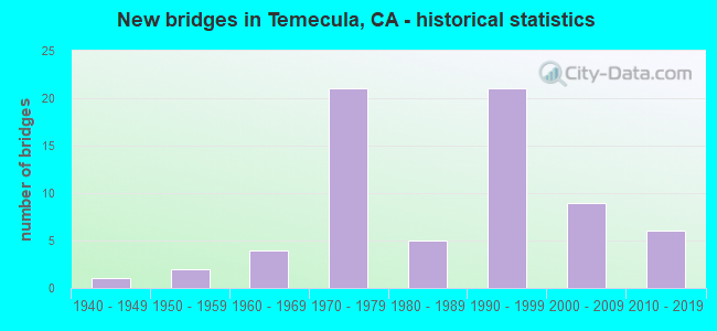
- New bridges - historical statistics
- 11940-1949
- 21950-1959
- 41960-1969
- 211970-1979
- 51980-1989
- 211990-1999
- 92000-2009
- 62010-2019
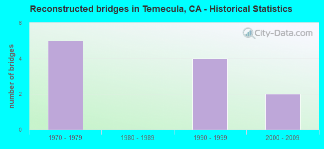
- Reconstructed bridges - Historical Statistics
- 51970-1979
- 01980-1989
- 41990-1999
- 22000-2009
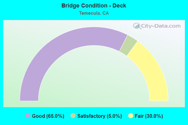
- Bridge Condition - Deck
- 65.0%Good
- 5.0%Satisfactory
- 30.0%Fair
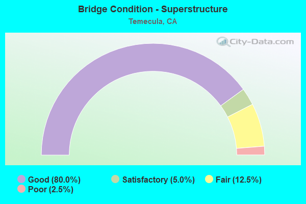
- Bridge Condition - Superstructure
- 80.0%Good
- 5.0%Satisfactory
- 12.5%Fair
- 2.5%Poor
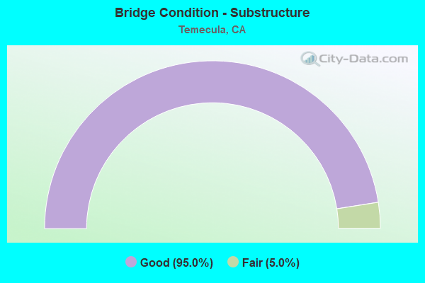
- Bridge Condition - Substructure
- 95.0%Good
- 5.0%Fair
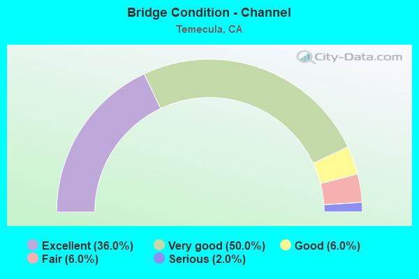
- Bridge Condition - Channel
- 36.0%Excellent
- 50.0%Very good
- 6.0%Good
- 6.0%Fair
- 2.0%Serious
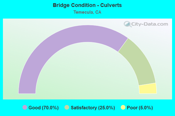
- Bridge Condition - Culverts
- 70.0%Good
- 25.0%Satisfactory
- 5.0%Poor
Find on map >> Show street view
Structure Number: 56 0040L, Location: 08-RIV-010-R110.47 (Lat: 33.701469, Lng: -115.307761), Route carried "on" structure: Interstate 10, Year Built: 1966, Status: Open, Structure Length: 2.18m (7.15ft), Average Daily Traffic: 10,700 (year 2012), Truck Traffic: 38%, Average Future Daily Traffic: 19,536 (year 2038), Design Load: HS 20, Features Intersected: PALEN DITCH
Minimum Vertical Clearance: 30+ m (98+ ft), Kilometerpoint: 110.470, Lanes on structure: 2, Base Highway Network: Yes (, Subroute: 1), Owner: State Highway Agency, Approaching Roadway Width: 11.9m (39.0ft), Material/Design: Concrete continuous, Design/Construction: Slab, Number Of Spans In Main Unit: 4, Length of Maximum Span: 6.1m (20.0ft), Curb-To-Curb Width: 11.9m (39.0ft), Out-to-Out Width: 12.7m (41.7ft)
Condition: Deck: Good, Superstructure: Good, Substructure: Good, Channel: Serious, Operating Rating: 39.9 metric tons, Method Used To Determine Operating Rating: Load and Resistance Factor Rating (LRFR) rating reported by rating factor(RF) method using HL-93 loadings, Inventory Rating: 30.8 metric tons, Method Used To Determine Inventory Rating: Load and Resistance Factor Rating (LRFR) rating reported by rating factor(RF) method using HL-93 loadings, Structural Evaluation: Better than present minimum criteria, Deck Geometry: Equal to present minimum criteria, Waterway Adequacy: Equal to present desirable criteria, Approach Roadway Alignment: Equal to present desirable criteria, Designated Inspection Frequency: Every 24 months, Inspection Date: March 2021, Deck Structure Type: Concrete Cast-file-Place, Wearing Surface/Protective System: Wearing Surface: Bituminous
Find on map >> Show street view
Structure Number: 56 0047L, Location: 08-RIV-015-R2.96-TMCA (Lat: 33.473992, Lng: -117.138422), Route carried "on" structure: Interstate 15, Year Built: 1973, Status: Open, Structure Length: 9.63m (31.59ft), Average Daily Traffic: 64,750 (year 2021), Truck Traffic: 7%, Average Future Daily Traffic: 105,650 (year 2038), Design Load: HS 20+Mod, Features Intersected: TEMECULA RIVER
Minimum Vertical Clearance: 30+ m (98+ ft), Kilometerpoint: 2.960, Lanes on structure: 4, Base Highway Network: Yes (, Subroute: 1), Owner: State Highway Agency, Approaching Roadway Width: 20.1m (65.9ft), Skew: 2 degrees, Material/Design: Concrete continuous, Design/Construction: Box Beam or Girders - Multiple, Number Of Spans In Main Unit: 4, Length of Maximum Span: 27.4m (89.9ft), Curb-To-Curb Width: 20.1m (65.9ft), Out-to-Out Width: 20.7m (67.9ft)
Condition: Deck: Good, Superstructure: Good, Substructure: Good, Channel: Fair, Operating Rating: 63.5 metric tons, Method Used To Determine Operating Rating: Load and Resistance Factor Rating (LRFR) rating reported by rating factor(RF) method using HL-93 loadings, Inventory Rating: 45.7 metric tons, Method Used To Determine Inventory Rating: Load and Resistance Factor Rating (LRFR) rating reported by rating factor(RF) method using HL-93 loadings, Structural Evaluation: Better than present minimum criteria, Deck Geometry: Equal to present minimum criteria, Waterway Adequacy: Equal to present desirable criteria, Approach Roadway Alignment: Superior to present desirable criteria, Designated Inspection Frequency: Every 24 months, Inspection Date: October 2021, Deck Structure Type: Concrete Cast-file-Place
Find on map >> Show street view
Structure Number: 56 0047R, Location: 08-RIV-015-R2.96-TMCA (Lat: 33.473942, Lng: -117.137989), Route carried "on" structure: Interstate 15, Year Built: 1973, Status: Open, Structure Length: 9.63m (31.59ft), Average Daily Traffic: 64,750 (year 2021), Truck Traffic: 7%, Average Future Daily Traffic: 105,650 (year 2038), Design Load: HS 20+Mod, Features Intersected: TEMECULA RIVER
Minimum Vertical Clearance: 30+ m (98+ ft), Kilometerpoint: 2.960, Lanes on structure: 4, Base Highway Network: Yes (, Subroute: 1), Owner: State Highway Agency, Approaching Roadway Width: 20.1m (65.9ft), Skew: 2 degrees, Material/Design: Concrete continuous, Design/Construction: Box Beam or Girders - Multiple, Number Of Spans In Main Unit: 4, Length of Maximum Span: 27.4m (89.9ft), Curb-To-Curb Width: 20.1m (65.9ft), Out-to-Out Width: 20.7m (67.9ft)
Condition: Deck: Good, Superstructure: Good, Substructure: Good, Channel: Fair, Operating Rating: 63.5 metric tons, Method Used To Determine Operating Rating: Load and Resistance Factor Rating (LRFR) rating reported by rating factor(RF) method using HL-93 loadings, Inventory Rating: 45.7 metric tons, Method Used To Determine Inventory Rating: Load and Resistance Factor Rating (LRFR) rating reported by rating factor(RF) method using HL-93 loadings, Structural Evaluation: Better than present minimum criteria, Deck Geometry: Equal to present minimum criteria, Waterway Adequacy: Equal to present desirable criteria, Approach Roadway Alignment: Superior to present desirable criteria, Designated Inspection Frequency: Every 24 months, Inspection Date: October 2021, Deck Structure Type: Concrete Cast-file-Place
Find on map >> Show street view
Structure Number: 56 0261L, Location: 08-RIV-015-5.41-TMCA (Lat: 33.506672, Lng: -117.154175), Route carried "on" structure: Interstate 15, Year Built: 1949, Year Reconstructed: 1976, Status: Open, Structure Length: 1.60m (5.25ft), Average Daily Traffic: 163,000 (year 2021), Truck Traffic: 40%, Average Future Daily Traffic: 182,003 (year 2039), Design Load: HS 20+Mod, Features Intersected: EMPIRE CREEK
Minimum Vertical Clearance: 30+ m (98+ ft), Kilometerpoint: 5.410, Lanes on structure: 4, Base Highway Network: Yes (, Subroute: 1), Owner: State Highway Agency, Approaching Roadway Width: 20.1m (65.9ft), Material/Design: Concrete continuous, Design/Construction: Slab, Number Of Spans In Main Unit: 3, Length of Maximum Span: 6.1m (20.0ft), Curb-To-Curb Width: 20.1m (65.9ft), Out-to-Out Width: 21.0m (68.9ft)
Condition: Deck: Good, Superstructure: Good, Substructure: Good, Channel: Very good, Operating Rating: 49.6 metric tons, Method Used To Determine Operating Rating: Load Factor (LF), Inventory Rating: 29.8 metric tons, Method Used To Determine Inventory Rating: Load Factor (LF), Structural Evaluation: Better than present minimum criteria, Deck Geometry: Equal to present minimum criteria, Waterway Adequacy: Better than present minimum criteria, Approach Roadway Alignment: Superior to present desirable criteria, Designated Inspection Frequency: Every 24 months, Inspection Date: October 2021, Deck Structure Type: Concrete Cast-file-Place, Wearing Surface/Protective System: Wearing Surface: Bituminous
Find on map >> Show street view
Structure Number: 56 0261R, Location: 08-RIV-015-5.41-TMCA (Lat: 33.506783, Lng: -117.153814), Route carried "on" structure: Interstate 15, Year Built: 1968, Year Reconstructed: 1976, Status: Open, Structure Length: 1.56m (5.12ft), Average Daily Traffic: 163,000 (year 2021), Truck Traffic: 7%, Average Future Daily Traffic: 182,003 (year 2039), Design Load: HS 20+Mod, Features Intersected: EMPIRE CREEK
Minimum Vertical Clearance: 30+ m (98+ ft), Kilometerpoint: 5.410, Lanes on structure: 4, Base Highway Network: Yes (, Subroute: 1), Owner: State Highway Agency, Approaching Roadway Width: 20.1m (65.9ft), Material/Design: Concrete continuous, Design/Construction: Slab, Number Of Spans In Main Unit: 3, Length of Maximum Span: 6.1m (20.0ft), Curb-To-Curb Width: 20.1m (65.9ft), Out-to-Out Width: 21.0m (68.9ft)
Condition: Deck: Good, Superstructure: Good, Substructure: Good, Channel: Very good, Operating Rating: 50.5 metric tons, Method Used To Determine Operating Rating: Load Factor (LF), Inventory Rating: 30.5 metric tons, Method Used To Determine Inventory Rating: Load Factor (LF), Structural Evaluation: Better than present minimum criteria, Deck Geometry: Equal to present minimum criteria, Waterway Adequacy: Better than present minimum criteria, Approach Roadway Alignment: Superior to present desirable criteria, Designated Inspection Frequency: Every 24 months, Inspection Date: October 2021, Deck Structure Type: Concrete Cast-file-Place, Wearing Surface/Protective System: Wearing Surface: Bituminous
Find on map >> Show street view
Structure Number: 56 0271K, Location: 08-RIV-015-6.73-TMCA (Lat: 33.523822, Lng: -117.164544), Route carried "on" structure: Ramp Interstate 15, Year Built: 1976, Year Reconstructed: 2014, Status: Open, Structure Length: 5.50m (18.04ft), Average Daily Traffic: 7,000 (year 2021), Truck Traffic: 1%, Average Future Daily Traffic: 8,642 (year 2039), Design Load: HS 20, Features Intersected: SANTA GERTRUDIS CREEK
Minimum Vertical Clearance: 30+ m (98+ ft), Kilometerpoint: 6.730, Lanes on structure: 2, Owner: State Highway Agency, Approaching Roadway Width: 12.2m (40.0ft), Skew: 9 degrees, Material/Design: Concrete continuous, Design/Construction: Slab, Number Of Spans In Main Unit: 7, Length of Maximum Span: 8.5m (27.9ft), Curb-To-Curb Width: 12.2m (40.0ft), Out-to-Out Width: 13.1m (43.0ft)
Condition: Deck: Good, Superstructure: Good, Substructure: Good, Channel: Very good, Operating Rating: 64.5 metric tons, Method Used To Determine Operating Rating: Load Factor (LF), Inventory Rating: 38.9 metric tons, Method Used To Determine Inventory Rating: Load Factor (LF), Structural Evaluation: Better than present minimum criteria, Deck Geometry: Superior to present desirable criteria, Waterway Adequacy: Equal to present desirable criteria, Approach Roadway Alignment: High priority of corrective action, Designated Inspection Frequency: Every 24 months, Inspection Date: October 2021, Deck Structure Type: Concrete Cast-file-Place
Find on map >> Show street view
Structure Number: 56 0271L, Location: 08-RIV-015-6.73-TMCA (Lat: 33.523936, Lng: -117.164047), Route carried "on" structure: Interstate 15, Year Built: 1951, Year Reconstructed: 1976, Status: Open, Structure Length: 5.63m (18.47ft), Average Daily Traffic: 182,000 (year 2021), Truck Traffic: 7%, Average Future Daily Traffic: 203,355 (year 2039), Design Load: HS 20+Mod, Features Intersected: SANTA GERTRUDIS CREEK
Minimum Vertical Clearance: 30+ m (98+ ft), Kilometerpoint: 6.730, Lanes on structure: 4, Base Highway Network: Yes (, Subroute: 1), Owner: State Highway Agency, Approaching Roadway Width: 20.1m (65.9ft), Skew: 1 degrees, Material/Design: Concrete continuous, Design/Construction: Slab, Number Of Spans In Main Unit: 7, Length of Maximum Span: 8.5m (27.9ft), Curb-To-Curb Width: 20.1m (65.9ft), Out-to-Out Width: 21.0m (68.9ft)
Condition: Deck: Good, Superstructure: Good, Substructure: Good, Channel: Very good, Operating Rating: 49.9 metric tons, Method Used To Determine Operating Rating: Load Factor (LF), Inventory Rating: 30.1 metric tons, Method Used To Determine Inventory Rating: Load Factor (LF), Structural Evaluation: Better than present minimum criteria, Deck Geometry: Equal to present minimum criteria, Waterway Adequacy: Equal to present desirable criteria, Approach Roadway Alignment: Superior to present desirable criteria, Designated Inspection Frequency: Every 24 months, Inspection Date: October 2021, Deck Structure Type: Concrete Cast-file-Place, Wearing Surface/Protective System: Wearing Surface: Bituminous
Find on map >> Show street view
Structure Number: 56 0271R, Location: 08-RIV-015-6.73-TMCA (Lat: 33.524025, Lng: -117.163628), Route carried "on" structure: Interstate 15, Year Built: 1968, Year Reconstructed: 1996, Status: Open, Structure Length: 5.60m (18.37ft), Average Daily Traffic: 182,000 (year 2021), Truck Traffic: 7%, Average Future Daily Traffic: 203,355 (year 2039), Design Load: HS 20+Mod, Features Intersected: SANTA GERTRUDIS CREEK
Minimum Vertical Clearance: 30+ m (98+ ft), Kilometerpoint: 6.730, Lanes on structure: 4, Base Highway Network: Yes (, Subroute: 1), Owner: State Highway Agency, Approaching Roadway Width: 21.8m (71.5ft), Skew: 31 degrees, Material/Design: Concrete continuous, Design/Construction: Slab, Number Of Spans In Main Unit: 7, Length of Maximum Span: 8.5m (27.9ft), Curb-To-Curb Width: 21.8m (71.5ft), Out-to-Out Width: 22.8m (74.8ft)
Condition: Deck: Good, Superstructure: Good, Substructure: Good, Channel: Very good, Operating Rating: 72.3 metric tons, Method Used To Determine Operating Rating: Load Factor (LF), Inventory Rating: 43.4 metric tons, Method Used To Determine Inventory Rating: Load Factor (LF), Structural Evaluation: Better than present minimum criteria, Deck Geometry: Better than present minimum criteria, Waterway Adequacy: Equal to present desirable criteria, Approach Roadway Alignment: Superior to present desirable criteria, Designated Inspection Frequency: Every 24 months, Inspection Date: October 2021, Deck Structure Type: Concrete Cast-file-Place, Wearing Surface/Protective System: Wearing Surface: Bituminous
Find on map >> Show street view
Structure Number: 56 0271S, Location: 08-RIV-015-6.73-TMCA (Lat: 33.524122, Lng: -117.163161), Route carried "on" structure: Ramp Interstate 15, Year Built: 1976, Status: Open, Structure Length: 6.18m (20.28ft), Average Daily Traffic: 9,000 (year 2021), Truck Traffic: 10%, Average Future Daily Traffic: 11,277 (year 2039), Design Load: HS 20, Features Intersected: SANTA GERTRUDIS CREEK
Minimum Vertical Clearance: 30+ m (98+ ft), Kilometerpoint: 6.730, Lanes on structure: 1, Owner: State Highway Agency, Approaching Roadway Width: 7.6m (24.9ft), Skew: 2 degrees, Material/Design: Concrete continuous, Design/Construction: Slab, Number Of Spans In Main Unit: 7, Length of Maximum Span: 9.4m (30.8ft), Curb-To-Curb Width: 7.6m (24.9ft), Out-to-Out Width: 8.5m (27.9ft)
Condition: Deck: Good, Superstructure: Good, Substructure: Good, Channel: Very good, Operating Rating: 54.4 metric tons, Method Used To Determine Operating Rating: Load Factor (LF), Inventory Rating: 32.7 metric tons, Method Used To Determine Inventory Rating: Load Factor (LF), Structural Evaluation: Better than present minimum criteria, Deck Geometry: Better than present minimum criteria, Waterway Adequacy: Equal to present desirable criteria, Approach Roadway Alignment: Superior to present desirable criteria, Designated Inspection Frequency: Every 24 months, Inspection Date: October 2021, Deck Structure Type: Concrete Cast-file-Place
Find on map >> Show street view
Structure Number: 56 0272L, Location: 08-RIV-015-7.78-TMCA (Lat: 33.537208, Lng: -117.172892), Route carried "on" structure: Interstate 15, Year Built: 1951, Year Reconstructed: 1977, Status: Open, Structure Length: 5.18m (16.99ft), Average Daily Traffic: 64,750 (year 2021), Truck Traffic: 7%, Average Future Daily Traffic: 107,423 (year 2039), Design Load: HS 20, Features Intersected: WARM SPRINGS CREEK
Minimum Vertical Clearance: 30+ m (98+ ft), Kilometerpoint: 7.780, Lanes on structure: 5, Base Highway Network: Yes (, Subroute: 1), Owner: State Highway Agency, Approaching Roadway Width: 23.8m (78.1ft), Skew: 2 degrees, Material/Design: Concrete continuous, Design/Construction: Slab, Number Of Spans In Main Unit: 6, Length of Maximum Span: 8.5m (27.9ft), Curb-To-Curb Width: 23.8m (78.1ft), Out-to-Out Width: 24.6m (80.7ft)
Condition: Deck: Satisfactory, Superstructure: Satisfactory, Substructure: Good, Channel: Good, Operating Rating: 54.4 metric tons, Method Used To Determine Operating Rating: Load Factor (LF), Inventory Rating: 32.7 metric tons, Method Used To Determine Inventory Rating: Load Factor (LF), Structural Evaluation: Equal to present minimum criteria, Deck Geometry: Equal to present minimum criteria, Waterway Adequacy: Equal to present desirable criteria, Approach Roadway Alignment: Superior to present desirable criteria, Designated Inspection Frequency: Every 24 months, Inspection Date: December 2021, Deck Structure Type: Concrete Cast-file-Place, Wearing Surface/Protective System: Wearing Surface: Bituminous
Find on map >> Show street view
Structure Number: 56 0272R, Location: 08-RIV-015-7.78-TMCA (Lat: 33.537531, Lng: -117.172614), Route carried "on" structure: Interstate 15, Year Built: 1968, Year Reconstructed: 1977, Status: Open, Structure Length: 5.22m (17.13ft), Average Daily Traffic: 64,750 (year 2021), Truck Traffic: 7%, Average Future Daily Traffic: 107,423 (year 2039), Design Load: HS 20, Features Intersected: WARM SPRINGS CREEK
Minimum Vertical Clearance: 30+ m (98+ ft), Kilometerpoint: 7.780, Lanes on structure: 5, Base Highway Network: Yes (, Subroute: 1), Owner: State Highway Agency, Approaching Roadway Width: 23.8m (78.1ft), Skew: 2 degrees, Material/Design: Concrete continuous, Design/Construction: Slab, Number Of Spans In Main Unit: 6, Length of Maximum Span: 9.1m (29.9ft), Curb-To-Curb Width: 23.8m (78.1ft), Out-to-Out Width: 24.6m (80.7ft)
Condition: Deck: Satisfactory, Superstructure: Satisfactory, Substructure: Fair, Channel: Good, Operating Rating: 38.6 metric tons, Method Used To Determine Operating Rating: Load and Resistance Factor Rating (LRFR) rating reported by rating factor(RF) method using HL-93 loadings, Inventory Rating: 26.6 metric tons, Method Used To Determine Inventory Rating: Load and Resistance Factor Rating (LRFR) rating reported by rating factor(RF) method using HL-93 loadings, Structural Evaluation: Somewhat better than minimum adequacy, Deck Geometry: Equal to present minimum criteria, Waterway Adequacy: Equal to present desirable criteria, Approach Roadway Alignment: Superior to present desirable criteria, Designated Inspection Frequency: Every 24 months, Inspection Date: December 2021, Deck Structure Type: Concrete Cast-file-Place, Wearing Surface/Protective System: Wearing Surface: Bituminous
Find on map >> Show street view
Structure Number: 56 0653K, Location: 08-RIV-015-3.42-TMCA (Lat: 33.480656, Lng: -117.141231), Route carried "on" structure: Ramp Interstate 15, Year Built: 2018, Status: Open, Structure Length: 5.39m (17.68ft), Average Daily Traffic: 10,150 (year 2021), Truck Traffic: 10%, Average Future Daily Traffic: 13,860 (year 2038), Design Load: HL 93, Features Intersected: TEMECULA PARKWAY
Minimum Vertical Clearance: 30+ m (98+ ft), Kilometerpoint: 3.420, Lanes on structure: 2, Lanes under structure: 6, Base Highway Network: Yes, Owner: State Highway Agency, Approaching Roadway Width: 11.0m (36.1ft), Skew: 4 degrees, Material/Design: Prestressed concrete, Design/Construction: Box Beam or Girders - Multiple, Number Of Spans In Main Unit: 1, Length of Maximum Span: 53.9m (176.8ft), Curb-To-Curb Width: 11.0m (36.1ft), Out-to-Out Width: 12.0m (39.4ft)
Condition: Deck: Good, Superstructure: Good, Substructure: Good, Operating Rating: 42.1 metric tons, Method Used To Determine Operating Rating: Assigned ratings based on Load and Resistance Factor Design (LRFD) reported by rating factor (RF) using HL93 loadings, Inventory Rating: 32.4 metric tons, Method Used To Determine Inventory Rating: Assigned ratings based on Load and Resistance Factor Design (LRFD) reported by rating factor (RF) using HL93 loadings, Structural Evaluation: Better than present minimum criteria, Deck Geometry: Better than present minimum criteria, Underclear: Meets minimum limits, Approach Roadway Alignment: Equal to present desirable criteria, Designated Inspection Frequency: Every 24 months, Inspection Date: October 2021, Deck Structure Type: Concrete Cast-file-Place
Find on map >> Show street view
Structure Number: 56 0653L, Location: 08-RIV-015-3.42-TMCA (Lat: 33.480497, Lng: -117.140767), Route carried "on" structure: Interstate 15, Year Built: 1976, Status: Open, Structure Length: 5.27m (17.29ft), Average Daily Traffic: 134,000 (year 2021), Truck Traffic: 7%, Average Future Daily Traffic: 183,020 (year 2039), Design Load: HS 20+Mod, Features Intersected: TEMECULA PARKWAY
Minimum Vertical Clearance: 30+ m (98+ ft), Kilometerpoint: 3.420, Lanes on structure: 4, Lanes under structure: 6, Base Highway Network: Yes (, Subroute: 1), Owner: State Highway Agency, Approaching Roadway Width: 20.1m (65.9ft), Skew: 4 degrees, Material/Design: Prestressed concrete, Design/Construction: Box Beam or Girders - Multiple, Number Of Spans In Main Unit: 1, Length of Maximum Span: 52.7m (172.9ft), Curb-To-Curb Width: 20.1m (65.9ft), Out-to-Out Width: 20.7m (67.9ft)
Condition: Deck: Good, Superstructure: Good, Substructure: Good, Operating Rating: 85.5 metric tons, Method Used To Determine Operating Rating: Load Factor (LF), Inventory Rating: 32.4 metric tons, Method Used To Determine Inventory Rating: Load Factor (LF), Structural Evaluation: Better than present minimum criteria, Deck Geometry: Equal to present minimum criteria, Underclear: High priority of corrective action, Approach Roadway Alignment: Superior to present desirable criteria, Designated Inspection Frequency: Every 24 months, Inspection Date: October 2021, Deck Structure Type: Concrete Cast-file-Place
Find on map >> Show street view
Structure Number: 56 0653R, Location: 08-RIV-015-3.42-TMCA (Lat: 33.480272, Lng: -117.140272), Route carried "on" structure: Interstate 15, Year Built: 1976, Status: Open, Structure Length: 5.26m (17.26ft), Average Daily Traffic: 134,000 (year 2021), Truck Traffic: 7%, Average Future Daily Traffic: 214,845 (year 2038), Design Load: HS 20, Features Intersected: TEMECULA PARKWAY
Minimum Vertical Clearance: 30+ m (98+ ft), Kilometerpoint: 3.420, Lanes on structure: 4, Lanes under structure: 6, Base Highway Network: Yes (, Subroute: 1), Owner: State Highway Agency, Approaching Roadway Width: 20.1m (65.9ft), Skew: 4 degrees, Material/Design: Prestressed concrete, Design/Construction: Box Beam or Girders - Multiple, Number Of Spans In Main Unit: 1, Length of Maximum Span: 52.6m (172.6ft), Curb-To-Curb Width: 20.1m (65.9ft), Out-to-Out Width: 20.7m (67.9ft)
Condition: Deck: Good, Superstructure: Good, Substructure: Good, Operating Rating: 85.5 metric tons, Method Used To Determine Operating Rating: Load Factor (LF), Inventory Rating: 32.4 metric tons, Method Used To Determine Inventory Rating: Load Factor (LF), Structural Evaluation: Better than present minimum criteria, Deck Geometry: Equal to present minimum criteria, Underclear: High priority of corrective action, Approach Roadway Alignment: Superior to present desirable criteria, Designated Inspection Frequency: Every 24 months, Inspection Date: October 2021, Deck Structure Type: Concrete Cast-file-Place
Find on map >> Show street view
Structure Number: 56 0654, Location: 08-RIV-015-4.12-TMCA (Lat: 33.490411, Lng: -117.144675), Route carried "on" structure: County highway , Year Built: 1976, Status: Open, Structure Length: 11.74m (38.52ft), Average Daily Traffic: 1,000 (year 2021), Truck Traffic: 1%, Average Future Daily Traffic: 1,148 (year 2039), Design Load: HS 20, Features Intersected: INTERSTATE 15, Facility Carried by Structure: SANTIAGO ROAD
Minimum Vertical Clearance: 30+ m (98+ ft), Kilometerpoint: 4.120, Lanes on structure: 2, Lanes under structure: 8, Owner: State Highway Agency, Approaching Roadway Width: 12.2m (40.0ft), Skew: 5 degrees, Material/Design: Prestressed concrete continuous, Design/Construction: Box Beam or Girders - Multiple, Number Of Spans In Main Unit: 2, Length of Maximum Span: 58.5m (191.9ft), Curb or Sidewalk Widths: Left: 0.0m, Right: 1.5m (4.9ft), Curb-To-Curb Width: 12.2m (40.0ft), Out-to-Out Width: 14.3m (46.9ft)
Condition: Deck: Fair, Superstructure: Good, Substructure: Good, Operating Rating: 99.8 metric tons, Method Used To Determine Operating Rating: Load Factor (LF), Inventory Rating: 32.4 metric tons, Method Used To Determine Inventory Rating: Load Factor (LF), Structural Evaluation: Better than present minimum criteria, Deck Geometry: Equal to present desirable criteria, Underclear: Meets minimum limits, Approach Roadway Alignment: Superior to present desirable criteria, Designated Inspection Frequency: Every 24 months, Inspection Date: October 2021, Deck Structure Type: Concrete Cast-file-Place
Find on map >> Show street view
Structure Number: 56 0655, Location: 08-RIV-015-4.98-TMCA (Lat: 33.500444, Lng: -117.151617), Route carried "on" structure: County highway W561, Year Built: 1976, Year Reconstructed: 1999, Status: Open, Structure Length: 8.06m (26.44ft), Average Daily Traffic: 8,000 (year 2021), Truck Traffic: 1%, Average Future Daily Traffic: 9,398 (year 2039), Design Load: HS 20, Features Intersected: INTERSTATE 15, Facility Carried by Structure: RANCHO CALIFORNIA
Minimum Vertical Clearance: 30+ m (98+ ft), Kilometerpoint: 0.000, Lanes on structure: 9, Lanes under structure: 8, Owner: State Highway Agency, Approaching Roadway Width: 32.8m (107.6ft), Skew: 1 degrees, Material/Design: Prestressed concrete continuous, Design/Construction: Box Beam or Girders - Multiple, Number Of Spans In Main Unit: 2, Length of Maximum Span: 41.1m (134.8ft), Curb or Sidewalk Widths: Left: 1.5m (4.9ft), Right: 0.0m, Curb-To-Curb Width: 32.8m (107.6ft), Out-to-Out Width: 38.7m (127.0ft)
Condition: Deck: Good, Superstructure: Good, Substructure: Good, Operating Rating: 41.5 metric tons, Method Used To Determine Operating Rating: Load and Resistance Factor Rating (LRFR) rating reported by rating factor(RF) method using HL-93 loadings, Inventory Rating: 28.2 metric tons, Method Used To Determine Inventory Rating: Load and Resistance Factor Rating (LRFR) rating reported by rating factor(RF) method using HL-93 loadings, Structural Evaluation: Better than present minimum criteria, Deck Geometry: Meets minimum limits, Underclear: Equal to present minimum criteria, Approach Roadway Alignment: Superior to present desirable criteria, Designated Inspection Frequency: Every 24 months, Inspection Date: October 2021, Deck Structure Type: Concrete Cast-file-Place
Find on map >> Show street view
Structure Number: 56 0656, Location: 08-RIV-015-6.62-TMCA (Lat: 33.522067, Lng: -117.163239), Route carried "on" structure: City street , Year Built: 1976, Year Reconstructed: 1997, Status: Open, Structure Length: 8.56m (28.08ft), Average Daily Traffic: 8,500 (year 2021), Truck Traffic: 10%, Average Future Daily Traffic: 8,771 (year 2039), Design Load: HS 20, Features Intersected: INTERSTATE 15, Facility Carried by Structure: WINCHESTER ROAD
Minimum Vertical Clearance: 30+ m (98+ ft), Kilometerpoint: 0.000, Lanes on structure: 8, Lanes under structure: 10, Owner: State Highway Agency, Approaching Roadway Width: 36.0m (118.1ft), Skew: 1 degrees, Material/Design: Prestressed concrete continuous, Design/Construction: Box Beam or Girders - Multiple, Number Of Spans In Main Unit: 2, Length of Maximum Span: 45.4m (149.0ft), Curb or Sidewalk Widths: Left: 0.0m, Right: 1.5m (4.9ft), Curb-To-Curb Width: 36.0m (118.1ft), Out-to-Out Width: 39.0m (128.0ft)
Condition: Deck: Good, Superstructure: Good, Substructure: Good, Operating Rating: 99.8 metric tons, Method Used To Determine Operating Rating: Load Factor (LF), Inventory Rating: 32.4 metric tons, Method Used To Determine Inventory Rating: Load Factor (LF), Structural Evaluation: Better than present minimum criteria, Deck Geometry: Superior to present desirable criteria, Underclear: Meets minimum limits, Approach Roadway Alignment: Equal to present desirable criteria, Designated Inspection Frequency: Every 24 months, Inspection Date: October 2021, Deck Structure Type: Concrete Cast-file-Place
Find on map >> Show street view
Structure Number: 56 0703L, Location: 08-RIV-015-9.84-TMCA (Lat: 33.557942, Lng: -117.197311), Route carried "on" structure: Interstate 15, Year Built: 1977, Status: Open, Structure Length: 2.53m (8.30ft), Average Daily Traffic: 125,000 (year 2021), Truck Traffic: 7%, Average Future Daily Traffic: 147,433 (year 2039), Design Load: HS 20+Mod, Features Intersected: YODER WASH
Minimum Vertical Clearance: 30+ m (98+ ft), Kilometerpoint: 9.840, Lanes on structure: 3, Base Highway Network: Yes (, Subroute: 1), Owner: State Highway Agency, Approaching Roadway Width: 15.4m (50.5ft), Skew: 3 degrees, Material/Design: Prestressed concrete, Design/Construction: Box Beam or Girders - Multiple, Number Of Spans In Main Unit: 1, Length of Maximum Span: 24.7m (81.0ft), Curb-To-Curb Width: 15.4m (50.5ft), Out-to-Out Width: 16.5m (54.1ft)
Condition: Deck: Good, Superstructure: Good, Substructure: Good, Channel: Very good, Operating Rating: 46.7 metric tons, Method Used To Determine Operating Rating: Load and Resistance Factor Rating (LRFR) rating reported by rating factor(RF) method using HL-93 loadings, Inventory Rating: 36.0 metric tons, Method Used To Determine Inventory Rating: Load and Resistance Factor Rating (LRFR) rating reported by rating factor(RF) method using HL-93 loadings, Structural Evaluation: Better than present minimum criteria, Deck Geometry: Somewhat better than minimum adequacy, Waterway Adequacy: Equal to present desirable criteria, Approach Roadway Alignment: Equal to present desirable criteria, Designated Inspection Frequency: Every 24 months, Inspection Date: December 2021, Deck Structure Type: Concrete Cast-file-Place
Find on map >> Show street view
Structure Number: 56 0703R, Location: 08-RIV-015-9.83-TMCA (Lat: 33.558092, Lng: -117.196847), Route carried "on" structure: Interstate 15, Year Built: 1977, Status: Open, Structure Length: 2.20m (7.22ft), Average Daily Traffic: 125,000 (year 2021), Truck Traffic: 7%, Average Future Daily Traffic: 147,433 (year 2039), Design Load: HS 20+Mod, Features Intersected: YODER WASH
Minimum Vertical Clearance: 30+ m (98+ ft), Kilometerpoint: 9.830, Lanes on structure: 3, Base Highway Network: Yes (, Subroute: 1), Owner: State Highway Agency, Approaching Roadway Width: 15.4m (50.5ft), Skew: 3 degrees, Material/Design: Prestressed concrete, Design/Construction: Box Beam or Girders - Multiple, Number Of Spans In Main Unit: 1, Length of Maximum Span: 21.3m (69.9ft), Curb-To-Curb Width: 15.4m (50.5ft), Out-to-Out Width: 16.5m (54.1ft)
Condition: Deck: Good, Superstructure: Good, Substructure: Good, Channel: Excellent, Operating Rating: 30.8 metric tons, Method Used To Determine Operating Rating: Load and Resistance Factor Rating (LRFR) rating reported by rating factor(RF) method using HL-93 loadings, Inventory Rating: 24.0 metric tons, Method Used To Determine Inventory Rating: Load and Resistance Factor Rating (LRFR) rating reported by rating factor(RF) method using HL-93 loadings, Structural Evaluation: Somewhat better than minimum adequacy, Deck Geometry: Somewhat better than minimum adequacy, Waterway Adequacy: Superior to present desirable criteria, Approach Roadway Alignment: Equal to present desirable criteria, Designated Inspection Frequency: Every 24 months, Inspection Date: December 2021, Deck Structure Type: Concrete Cast-file-Place
Find on map >> Show street view
Structure Number: 56 0736, Location: 08-RIV-015-6.05-TMCA (Lat: 33.515381, Lng: -117.157917), Route carried "on" structure: Interstate 15, Year Built: 1976, Status: Open, Structure Length: 0.98m (3.22ft), Average Daily Traffic: 163,000 (year 2021), Truck Traffic: 6%, Average Future Daily Traffic: 182,003 (year 2039), Features Intersected: WADDELL WASH
Minimum Vertical Clearance: 30+ m (98+ ft), Kilometerpoint: 6.050, Lanes on structure: 8, Base Highway Network: Yes (, Subroute: 1), Owner: State Highway Agency, Approaching Roadway Width: 54.0m (177.2ft), Skew: 20 degrees, Material/Design: Concrete continuous, Design/Construction: Culvert, Number Of Spans In Main Unit: 4, Length of Maximum Span: 2.4m (7.9ft), Curb-To-Curb Width: 54.0m (177.2ft), Out-to-Out Width: 54.0m (177.2ft)
Condition: Channel: Excellent, Culverts: Good, Operating Rating: 54.1 metric tons, Method Used To Determine Operating Rating: Field evaluation and documented engineering judgment, Inventory Rating: 32.4 metric tons, Method Used To Determine Inventory Rating: Field evaluation and documented engineering judgment, Structural Evaluation: Better than present minimum criteria, Deck Geometry: Superior to present desirable criteria, Waterway Adequacy: Better than present minimum criteria, Approach Roadway Alignment: Equal to present desirable criteria, Designated Inspection Frequency: Every 24 months, Inspection Date: October 2021
Find on map >> Show street view
Structure Number: 56 079, Location: 08-RIV-074-62.99 (Lat: 33.672036, Lng: -116.678178), Route carried "on" structure: State highway 74, Year Built: 2016, Status: Open, Structure Length: 1.40m (4.59ft), Average Daily Traffic: 3,050 (year 2009), Truck Traffic: 7%, Average Future Daily Traffic: 8,365 (year 2039), Design Load: HL 93, Features Intersected: HURKEY CREEK
Minimum Vertical Clearance: 30+ m (98+ ft), Kilometerpoint: 62.990, Lanes on structure: 2, Base Highway Network: Yes (, Subroute: 1), Owner: State Highway Agency, Approaching Roadway Width: 12.1m (39.7ft), Skew: 2 degrees, Material/Design: Prestressed concrete continuous, Design/Construction: Slab, Number Of Spans In Main Unit: 1, Length of Maximum Span: 11.1m (36.4ft), Curb-To-Curb Width: 12.1m (39.7ft), Out-to-Out Width: 13.3m (43.6ft)
Condition: Deck: Good, Superstructure: Good, Substructure: Good, Channel: Excellent, Operating Rating: 42.1 metric tons, Method Used To Determine Operating Rating: Assigned ratings based on Load and Resistance Factor Design (LRFD) reported by rating factor (RF) using HL93 loadings, Inventory Rating: 32.4 metric tons, Method Used To Determine Inventory Rating: Assigned ratings based on Load and Resistance Factor Design (LRFD) reported by rating factor (RF) using HL93 loadings, Structural Evaluation: Better than present minimum criteria, Deck Geometry: Somewhat better than minimum adequacy, Waterway Adequacy: Superior to present desirable criteria, Approach Roadway Alignment: Equal to present desirable criteria, Designated Inspection Frequency: Every 48 months, Inspection Date: June 2019, Deck Structure Type: Concrete Cast-file-Place, Wearing Surface/Protective System: Deck Protection: Epoxy Coated Reinforcing
Find on map >> Show street view
Structure Number: 56 0792, Location: 08-RIV-015-6.20-TMCA (Lat: 33.517314, Lng: -117.160200), Route carried "on" structure: City street , Year Built: 1998, Status: Open, Structure Length: 13.20m (43.31ft), Average Daily Traffic: 22,000 (year 2021), Truck Traffic: 1%, Average Future Daily Traffic: 25,186 (year 2039), Design Load: HS 20+Mod, Features Intersected: INTERSTATE 15, Facility Carried by Structure: OVERLAND DRIVE
Minimum Vertical Clearance: 30+ m (98+ ft), Kilometerpoint: 0.000, Lanes on structure: 4, Lanes under structure: 9, Owner: State Highway Agency, Approaching Roadway Width: 17.1m (56.1ft), Skew: 22 degrees, Material/Design: Prestressed concrete continuous, Design/Construction: Box Beam or Girders - Multiple, Number Of Spans In Main Unit: 4, Number Of Approach Spans: 8, Length of Maximum Span: 35.7m (117.1ft), Curb or Sidewalk Widths: Left: 1.5m (4.9ft), Right: 0.0m, Curb-To-Curb Width: 17.1m (56.1ft), Out-to-Out Width: 19.4m (63.6ft)
Condition: Deck: Good, Superstructure: Good, Substructure: Good, Operating Rating: 54.1 metric tons, Method Used To Determine Operating Rating: Assigned rating based on Load Factor Design (LFD) reported in metric tons, Inventory Rating: 32.4 metric tons, Method Used To Determine Inventory Rating: Assigned rating based on Load Factor Design (LFD) reported in metric tons, Structural Evaluation: Better than present minimum criteria, Deck Geometry: Somewhat better than minimum adequacy, Underclear: Equal to present minimum criteria, Approach Roadway Alignment: Superior to present desirable criteria, Designated Inspection Frequency: Every 24 months, Inspection Date: October 2021, Deck Structure Type: Concrete Cast-file-Place
Find on map >> Show street view
Structure Number: 56 0798, Location: 08-RIV-015-11.98-TMCA (Lat: 33.577522, Lng: -117.223444), Route carried "on" structure: County highway , Year Built: 2001, Status: Open, Structure Length: 7.43m (24.38ft), Average Daily Traffic: 4,000 (year 2021), Truck Traffic: 1%, Average Future Daily Traffic: 4,672 (year 2039), Design Load: HS 20+Mod, Features Intersected: INTERSTATE 15, Facility Carried by Structure: NUTMEG STREET
Minimum Vertical Clearance: 30+ m (98+ ft), Kilometerpoint: 12.000, Lanes on structure: 4, Lanes under structure: 6, Owner: State Highway Agency, Approaching Roadway Width: 18.6m (61.0ft), Skew: 10 degrees, Material/Design: Prestressed concrete continuous, Design/Construction: Box Beam or Girders - Multiple, Number Of Spans In Main Unit: 2, Number Of Approach Spans: 4, Length of Maximum Span: 37.7m (123.7ft), Curb or Sidewalk Widths: Left: 1.7m (5.6ft), Right: 1.7m (5.6ft), Curb-To-Curb Width: 18.6m (61.0ft), Out-to-Out Width: 22.6m (74.1ft)
Condition: Deck: Good, Superstructure: Good, Substructure: Good, Operating Rating: 54.1 metric tons, Method Used To Determine Operating Rating: Assigned rating based on Load Factor Design (LFD) reported in metric tons, Inventory Rating: 32.4 metric tons, Method Used To Determine Inventory Rating: Assigned rating based on Load Factor Design (LFD) reported in metric tons, Structural Evaluation: Better than present minimum criteria, Deck Geometry: Equal to present minimum criteria, Underclear: Equal to present minimum criteria, Approach Roadway Alignment: Better than present minimum criteria, Designated Inspection Frequency: Every 24 months, Inspection Date: December 2021, Deck Structure Type: Concrete Cast-file-Place
Find on map >> Show street view
Structure Number: 56 0852, Location: 08-RIV-015-10.03-TMCA (Lat: 33.559533, Lng: -117.199917), Route carried "on" structure: County highway W560, Year Built: 2015, Status: Open, Structure Length: 8.99m (29.49ft), Average Daily Traffic: 15,000 (year 2021), Truck Traffic: 1%, Average Future Daily Traffic: 31,000 (year 2039), Design Load: HL 93, Features Intersected: INTERSTATE 15, Facility Carried by Structure: LOS ALAMOS ROAD
Minimum Vertical Clearance: 30+ m (98+ ft), Kilometerpoint: 10.030, Lanes on structure: 4, Lanes under structure: 6, Owner: State Highway Agency, Approaching Roadway Width: 23.1m (75.8ft), Material/Design: Prestressed concrete continuous, Design/Construction: Box Beam or Girders - Multiple, Number Of Spans In Main Unit: 2, Length of Maximum Span: 45.4m (149.0ft), Curb or Sidewalk Widths: Left: 1.8m (5.9ft), Right: 1.8m (5.9ft), Curb-To-Curb Width: 23.1m (75.8ft), Out-to-Out Width: 27.4m (89.9ft)
Condition: Deck: Good, Superstructure: Good, Substructure: Good, Operating Rating: 42.1 metric tons, Method Used To Determine Operating Rating: Assigned ratings based on Load and Resistance Factor Design (LRFD) reported by rating factor (RF) using HL93 loadings, Inventory Rating: 32.4 metric tons, Method Used To Determine Inventory Rating: Assigned ratings based on Load and Resistance Factor Design (LRFD) reported by rating factor (RF) using HL93 loadings, Structural Evaluation: Better than present minimum criteria, Deck Geometry: Superior to present desirable criteria, Underclear: Better than present minimum criteria, Approach Roadway Alignment: Equal to present desirable criteria, Designated Inspection Frequency: Every 24 months, Inspection Date: December 2021, Deck Structure Type: Concrete Cast-file-Place
Find on map >> Show street view
Structure Number: 56C0042, Location: 0.2 MI. NW/O WINCHSTR RD (Lat: 33.522883, Lng: -117.166736), Route carried "on" structure: City street , Year Built: 1990, Status: Open, Structure Length: 3.08m (10.10ft), Average Daily Traffic: 22,000 (year 2010), Truck Traffic: 2%, Average Future Daily Traffic: 31,535 (year 2040), Design Load: HS 20, Features Intersected: SANTA GERTRUDIS CREEK, Facility Carried by Structure: JEFFERSON AVENUE
Minimum Vertical Clearance: 30+ m (98+ ft), Kilometerpoint: 0.000, Lanes on structure: 5, Owner: City or Municipal Highway Agency, Approaching Roadway Width: 19.0m (62.3ft), Skew: 30 degrees, Material/Design: Prestressed concrete, Design/Construction: Box Beam or Girders - Multiple, Number Of Spans In Main Unit: 1, Length of Maximum Span: 30.5m (100.1ft), Curb or Sidewalk Widths: Left: 1.5m (4.9ft), Right: 1.5m (4.9ft), Curb-To-Curb Width: 21.3m (69.9ft), Out-to-Out Width: 26.5m (86.9ft)
Condition: Deck: Fair, Superstructure: Poor, Substructure: Good, Channel: Very good, Operating Rating: 54.1 metric tons, Method Used To Determine Operating Rating: Assigned rating based on Load Factor Design (LFD) reported in metric tons, Inventory Rating: 32.4 metric tons, Method Used To Determine Inventory Rating: Assigned rating based on Load Factor Design (LFD) reported in metric tons, Structural Evaluation: Meets minimum limits, Deck Geometry: Somewhat better than minimum adequacy, Waterway Adequacy: Equal to present desirable criteria, Approach Roadway Alignment: Equal to present desirable criteria, Length Of Structure Improvement: 3.08m (10.10ft), Designated Inspection Frequency: Every 24 months, Inspection Date: November 2021, Bridge Improvement Cost: $808,000, Roadway Improvement Cost: $161,000, Total Project Cost: $1,357,000 ( Estimate for 2019), Deck Structure Type: Concrete Cast-file-Place
Find on map >> Show street view
Structure Number: 56C0226, Location: 0.2 MI. W/O RTE. I-15 FWY (Lat: 33.498394, Lng: -117.155181), Route carried "on" structure: City street , Year Built: 1970, Year Reconstructed: 2004, Status: Open, Structure Length: 11.01m (36.12ft), Average Daily Traffic: 37,000 (year 2010), Truck Traffic: 1%, Average Future Daily Traffic: 77,530 (year 2040), Design Load: HS 20, Features Intersected: MURRIETA CREEK, Facility Carried by Structure: RANCHO CALIF ROAD
Minimum Vertical Clearance: 30+ m (98+ ft), Kilometerpoint: 0.000, Lanes on structure: 7, Owner: City or Municipal Highway Agency, Approaching Roadway Width: 19.5m (64.0ft), Material/Design: Concrete continuous, Design/Construction: Box Beam or Girders - Multiple, Number Of Spans In Main Unit: 5, Length of Maximum Span: 24.4m (80.1ft), Curb or Sidewalk Widths: Left: 0.0m, Right: 1.5m (4.9ft), Curb-To-Curb Width: 34.2m (112.2ft), Out-to-Out Width: 36.5m (119.8ft)
Condition: Deck: Fair, Superstructure: Good, Substructure: Good, Channel: Fair, Operating Rating: 77.4 metric tons, Method Used To Determine Operating Rating: Load Factor (LF), Inventory Rating: 46.7 metric tons, Method Used To Determine Inventory Rating: Load Factor (LF), Structural Evaluation: Better than present minimum criteria, Deck Geometry: Superior to present desirable criteria, Waterway Adequacy: Equal to present desirable criteria, Approach Roadway Alignment: Equal to present desirable criteria, Designated Inspection Frequency: Every 24 months, Inspection Date: November 2021, Deck Structure Type: Concrete Cast-file-Place
Find on map >> Show street view
Structure Number: 56C0284, Location: 0.35 MI S/O PECHANGA PKWY (Lat: 33.468567, Lng: -117.128683), Route carried "on" structure: City street , Year Built: 1981, Status: Open, Structure Length: 2.13m (6.99ft), Average Daily Traffic: 7,000 (year 2004), Truck Traffic: 1%, Average Future Daily Traffic: 14,522 (year 2036), Design Load: HS 20, Features Intersected: PECHANGA CREEK, Facility Carried by Structure: RAINBOW CANYON RD.
Minimum Vertical Clearance: 30+ m (98+ ft), Kilometerpoint: 0.000, Lanes on structure: 2, Owner: City or Municipal Highway Agency, Approaching Roadway Width: 13.1m (43.0ft), Skew: 3 degrees, Material/Design: Concrete, Design/Construction: Culvert, Number Of Spans In Main Unit: 4, Length of Maximum Span: 4.7m (15.4ft), Curb-To-Curb Width: 11.7m (38.4ft), Out-to-Out Width: 12.8m (42.0ft)
Condition: Channel: Very good, Culverts: Good, Operating Rating: 54.1 metric tons, Method Used To Determine Operating Rating: Field evaluation and documented engineering judgment, Inventory Rating: 32.4 metric tons, Method Used To Determine Inventory Rating: Field evaluation and documented engineering judgment, Structural Evaluation: Better than present minimum criteria, Deck Geometry: Somewhat better than minimum adequacy, Waterway Adequacy: Equal to present desirable criteria, Approach Roadway Alignment: Equal to present desirable criteria, Designated Inspection Frequency: Every 48 months, Inspection Date: June 2018
Find on map >> Show street view
Structure Number: 56C0316, Location: 0.02 MI S CALE PINA COLDA (Lat: 33.525667, Lng: -117.139356), Route carried "on" structure: City street , Year Built: 1976, Status: Open, Structure Length: 1.01m (3.31ft), Average Daily Traffic: 3,000 (year 2009), Truck Traffic: 1%, Average Future Daily Traffic: 6,223 (year 2036), Features Intersected: MARGARITA CREEK, Facility Carried by Structure: VIA NORTE
Minimum Vertical Clearance: 30+ m (98+ ft), Kilometerpoint: 0.000, Lanes on structure: 2, Owner: City or Municipal Highway Agency, Approaching Roadway Width: 10.2m (33.5ft), Skew: 4 degrees, Material/Design: Concrete, Design/Construction: Culvert, Number Of Spans In Main Unit: 3, Length of Maximum Span: 3.1m (10.2ft), Curb or Sidewalk Widths: Left: 0.2m (0.7ft), Right: 0.2m (0.7ft), Curb-To-Curb Width: 9.7m (31.8ft), Out-to-Out Width: 23.8m (78.1ft)
Condition: Channel: Very good, Culverts: Good, Operating Rating: 54.1 metric tons, Method Used To Determine Operating Rating: Field evaluation and documented engineering judgment, Inventory Rating: 32.4 metric tons, Method Used To Determine Inventory Rating: Field evaluation and documented engineering judgment, Structural Evaluation: Better than present minimum criteria, Deck Geometry: Meets minimum limits, Waterway Adequacy: Equal to present desirable criteria, Approach Roadway Alignment: Equal to present desirable criteria, Designated Inspection Frequency: Every 48 months, Inspection Date: June 2018
Find on map >> Show street view
Structure Number: 56C0353, Location: 300' NW/O WINCHESTER RD. (Lat: 33.525383, Lng: -117.160811), Route carried "on" structure: City street , Year Built: 1987, Year Reconstructed: 2005, Status: Open, Structure Length: 4.63m (15.19ft), Average Daily Traffic: 13,000 (year 2010), Truck Traffic: 1%, Average Future Daily Traffic: 27,697 (year 2043), Design Load: HS 20+Mod, Features Intersected: SANTA GERTRUDIS CREEK, Facility Carried by Structure: YNEZ ROAD
Minimum Vertical Clearance: 30+ m (98+ ft), Kilometerpoint: 0.000, Lanes on structure: 5, Owner: City or Municipal Highway Agency, Approaching Roadway Width: 20.5m (67.3ft), Material/Design: Prestressed concrete continuous, Design/Construction: Stringer/Multi-beam, Number Of Spans In Main Unit: 2, Length of Maximum Span: 22.3m (73.2ft), Curb or Sidewalk Widths: Left: 1.5m (4.9ft), Right: 1.5m (4.9ft), Curb-To-Curb Width: 25.0m (82.0ft), Out-to-Out Width: 28.6m (93.8ft)
Condition: Deck: Fair, Superstructure: Good, Substructure: Good, Channel: Excellent, Operating Rating: 54.1 metric tons, Method Used To Determine Operating Rating: Assigned rating based on Load Factor Design (LFD) reported in metric tons, Inventory Rating: 32.4 metric tons, Method Used To Determine Inventory Rating: Assigned rating based on Load Factor Design (LFD) reported in metric tons, Structural Evaluation: Better than present minimum criteria, Deck Geometry: Superior to present desirable criteria, Waterway Adequacy: Equal to present desirable criteria, Approach Roadway Alignment: Equal to present desirable criteria, Designated Inspection Frequency: Every 24 months, Inspection Date: November 2021, Deck Structure Type: Concrete Cast-file-Place
Find on map >> Show street view
Structure Number: 56C0383, Location: 100' NE/O DIAZ ROAD (Lat: 33.515283, Lng: -117.169850), Route carried "on" structure: City street , Year Built: 1987, Status: Open, Structure Length: 9.39m (30.81ft), Average Daily Traffic: 17,000 (year 2010), Truck Traffic: 1%, Average Future Daily Traffic: 36,705 (year 2043), Design Load: HS 20+Mod, Features Intersected: MURRIETA CREEK, Facility Carried by Structure: WINCHESTER ROAD
Minimum Vertical Clearance: 30+ m (98+ ft), Kilometerpoint: 0.000, Lanes on structure: 4, Owner: City or Municipal Highway Agency, Approaching Roadway Width: 23.2m (76.1ft), Material/Design: Prestressed concrete continuous, Design/Construction: Slab, Number Of Spans In Main Unit: 5, Length of Maximum Span: 20.4m (66.9ft), Curb or Sidewalk Widths: Left: 0.0m, Right: 1.5m (4.9ft), Curb-To-Curb Width: 23.2m (76.1ft), Out-to-Out Width: 25.6m (84.0ft)
Condition: Deck: Fair, Superstructure: Fair, Substructure: Good, Channel: Very good, Operating Rating: 54.1 metric tons, Method Used To Determine Operating Rating: Assigned rating based on Load Factor Design (LFD) reported in metric tons, Inventory Rating: 32.4 metric tons, Method Used To Determine Inventory Rating: Assigned rating based on Load Factor Design (LFD) reported in metric tons, Structural Evaluation: Somewhat better than minimum adequacy, Deck Geometry: Superior to present desirable criteria, Waterway Adequacy: Equal to present desirable criteria, Approach Roadway Alignment: Equal to present desirable criteria, Designated Inspection Frequency: Every 24 months, Inspection Date: November 2021, Deck Structure Type: Concrete Cast-file-Place
Find on map >> Show street view
Structure Number: 56C0384, Location: 0.4 MI. S/O VIA MONTEZUMA (Lat: 33.506564, Lng: -117.154639), Route carried "on" structure: City street , Year Built: 1970, Status: Open, Structure Length: 0.76m (2.49ft), Average Daily Traffic: 18,000 (year 2010), Truck Traffic: 1%, Average Future Daily Traffic: 37,717 (year 2040), Features Intersected: EMPIRE CREEK, Facility Carried by Structure: JEFFERSON AVE
Minimum Vertical Clearance: 30+ m (98+ ft), Kilometerpoint: 0.000, Lanes on structure: 5, Owner: City or Municipal Highway Agency, Approaching Roadway Width: 23.2m (76.1ft), Material/Design: Concrete continuous, Design/Construction: Culvert, Number Of Spans In Main Unit: 2, Length of Maximum Span: 3.7m (12.1ft), Curb or Sidewalk Widths: Left: 1.5m (4.9ft), Right: 1.5m (4.9ft), Curb-To-Curb Width: 23.2m (76.1ft), Out-to-Out Width: 26.8m (87.9ft)
Condition: Channel: Very good, Culverts: Good, Operating Rating: 40.5 metric tons, Method Used To Determine Operating Rating: Field evaluation and documented engineering judgment, Inventory Rating: 24.3 metric tons, Method Used To Determine Inventory Rating: Field evaluation and documented engineering judgment, Structural Evaluation: Equal to present minimum criteria, Deck Geometry: Better than present minimum criteria, Waterway Adequacy: Somewhat better than minimum adequacy, Approach Roadway Alignment: Equal to present desirable criteria, Designated Inspection Frequency: Every 24 months, Inspection Date: November 2021
Find on map >> Show street view
Structure Number: 56C0385, Location: 0.2 MI. NW/O FRONT STREET (Lat: 33.505850, Lng: -117.156578), Route carried "on" structure: City street , Year Built: 1970, Status: Open, Structure Length: 1.19m (3.90ft), Average Daily Traffic: 2,000 (year 2010), Truck Traffic: 1%, Average Future Daily Traffic: 2,601 (year 2043), Features Intersected: EMPIRE CREEK, Facility Carried by Structure: DEL RIO ROAD
Minimum Vertical Clearance: 30+ m (98+ ft), Kilometerpoint: 0.000, Lanes on structure: 2, Owner: City or Municipal Highway Agency, Approaching Roadway Width: 14.0m (45.9ft), Material/Design: Concrete, Design/Construction: Culvert, Number Of Spans In Main Unit: 3, Length of Maximum Span: 3.7m (12.1ft), Curb or Sidewalk Widths: Left: 2.0m (6.6ft), Right: 2.0m (6.6ft), Curb-To-Curb Width: 14.0m (45.9ft), Out-to-Out Width: 18.6m (61.0ft)
Condition: Channel: Very good, Culverts: Satisfactory, Operating Rating: 40.5 metric tons, Method Used To Determine Operating Rating: Field evaluation and documented engineering judgment, Inventory Rating: 24.3 metric tons, Method Used To Determine Inventory Rating: Field evaluation and documented engineering judgment, Structural Evaluation: Equal to present minimum criteria, Deck Geometry: Superior to present desirable criteria, Waterway Adequacy: Better than present minimum criteria, Approach Roadway Alignment: Equal to present desirable criteria, Designated Inspection Frequency: Every 24 months, Inspection Date: November 2021, Deck Structure Type: Concrete Cast-file-Place
Find on map >> Show street view
Structure Number: 56C0386, Location: 50' N/O RANCHO CALIF. RD. (Lat: 33.498311, Lng: -117.157006), Route carried "on" structure: City street , Year Built: 1987, Status: Open, Structure Length: 0.85m (2.79ft), Average Daily Traffic: 12,000 (year 2010), Truck Traffic: 2%, Average Future Daily Traffic: 29,433 (year 2040), Design Load: HS 20, Features Intersected: RANCHO CALIF RD CHANNEL, Facility Carried by Structure: DIAZ ROAD
Minimum Vertical Clearance: 30+ m (98+ ft), Kilometerpoint: 0.000, Lanes on structure: 6, Owner: City or Municipal Highway Agency, Approaching Roadway Width: 16.8m (55.1ft), Skew: 20 degrees, Material/Design: Steel, Design/Construction: Culvert, Number Of Spans In Main Unit: 2, Length of Maximum Span: 4.3m (14.1ft), Curb or Sidewalk Widths: Left: 0.2m (0.7ft), Right: 1.8m (5.9ft)
Condition: Channel: Excellent, Culverts: Good, Operating Rating: 54.1 metric tons, Method Used To Determine Operating Rating: Field evaluation and documented engineering judgment, Inventory Rating: 32.4 metric tons, Method Used To Determine Inventory Rating: Field evaluation and documented engineering judgment, Structural Evaluation: Better than present minimum criteria, Waterway Adequacy: Equal to present desirable criteria, Approach Roadway Alignment: Equal to present minimum criteria, Designated Inspection Frequency: Every 24 months, Inspection Date: November 2021
Find on map >> Show street view
Structure Number: 56C0403, Location: 0.2 MI. S/O ROUTE 79 HWY. (Lat: 33.477036, Lng: -117.097314), Route carried "on" structure: County highway , Year Built: 1990, Status: Open, Structure Length: 16.46m (54.00ft), Average Daily Traffic: 23,000 (year 2010), Truck Traffic: 1%, Average Future Daily Traffic: 49,004 (year 2043), Design Load: HS 20+Mod, Features Intersected: TEMECULA CREEK, Facility Carried by Structure: REDHAWK PARKWAY
Minimum Vertical Clearance: 30+ m (98+ ft), Kilometerpoint: 0.000, Lanes on structure: 4, Owner: City or Municipal Highway Agency, Approaching Roadway Width: 23.3m (76.4ft), Skew: 3 degrees, Material/Design: Concrete continuous, Design/Construction: Box Beam or Girders - Multiple, Number Of Spans In Main Unit: 6, Length of Maximum Span: 27.4m (89.9ft), Curb or Sidewalk Widths: Left: 1.5m (4.9ft), Right: 1.5m (4.9ft), Curb-To-Curb Width: 23.3m (76.4ft), Out-to-Out Width: 26.8m (87.9ft)
Condition: Deck: Good, Superstructure: Fair, Substructure: Good, Channel: Very good, Operating Rating: 54.1 metric tons, Method Used To Determine Operating Rating: Assigned rating based on Load Factor Design (LFD) reported in metric tons, Inventory Rating: 32.4 metric tons, Method Used To Determine Inventory Rating: Assigned rating based on Load Factor Design (LFD) reported in metric tons, Structural Evaluation: Somewhat better than minimum adequacy, Deck Geometry: Superior to present desirable criteria, Waterway Adequacy: Superior to present desirable criteria, Approach Roadway Alignment: Equal to present desirable criteria, Designated Inspection Frequency: Every 24 months, Inspection Date: November 2021, Deck Structure Type: Concrete Cast-file-Place
Find on map >> Show street view
Structure Number: 56C042, Location: 0.5 MI. W/O JF KENNEDY DR (Lat: 33.909978, Lng: -117.165414), Route carried "on" structure: City street , Year Built: 1989, Status: Open, Structure Length: 1.31m (4.30ft), Average Daily Traffic: 2,700 (year 2012), Truck Traffic: 1%, Average Future Daily Traffic: 414 (year 2039), Features Intersected: STORM CHANNEL LINE G, Facility Carried by Structure: CACTUS AVENUE
Minimum Vertical Clearance: 30+ m (98+ ft), Kilometerpoint: 0.000, Lanes on structure: 3, Owner: City or Municipal Highway Agency, Approaching Roadway Width: 13.5m (44.3ft), Material/Design: Concrete, Design/Construction: Culvert, Number Of Spans In Main Unit: 5, Length of Maximum Span: 2.4m (7.9ft), Curb or Sidewalk Widths: Left: 1.8m (5.9ft), Right: 0.0m, Curb-To-Curb Width: 13.5m (44.3ft), Out-to-Out Width: 21.3m (69.9ft)
Condition: Channel: Very good, Culverts: Good, Operating Rating: 54.1 metric tons, Method Used To Determine Operating Rating: Field evaluation and documented engineering judgment, Inventory Rating: 32.4 metric tons, Method Used To Determine Inventory Rating: Field evaluation and documented engineering judgment, Structural Evaluation: Better than present minimum criteria, Deck Geometry: Somewhat better than minimum adequacy, Waterway Adequacy: Meets minimum limits, Approach Roadway Alignment: Equal to present desirable criteria, Designated Inspection Frequency: Every 48 months, Inspection Date: July 2021
Find on map >> Show street view
Structure Number: 56C0427, Location: 100' E/O REDHAWK PARKWAY (Lat: 33.472961, Lng: -117.092489), Route carried "on" structure: City street , Year Built: 1990, Status: Open, Structure Length: 0.98m (3.22ft), Average Daily Traffic: 8,000 (year 2011), Truck Traffic: 1%, Average Future Daily Traffic: 10,688 (year 2043), Design Load: HS 20, Features Intersected: GOLF COURSE DRAIN, Facility Carried by Structure: VAIL RANCH PARKWAY
Minimum Vertical Clearance: 30+ m (98+ ft), Kilometerpoint: 0.000, Lanes on structure: 5, Owner: City or Municipal Highway Agency, Approaching Roadway Width: 20.8m (68.2ft), Skew: 33 degrees, Material/Design: Steel, Design/Construction: Culvert, Number Of Spans In Main Unit: 2, Length of Maximum Span: 4.3m (14.1ft), Curb or Sidewalk Widths: Left: 1.8m (5.9ft), Right: 1.8m (5.9ft)
Condition: Channel: Very good, Culverts: Satisfactory, Operating Rating: 54.1 metric tons, Method Used To Determine Operating Rating: Field evaluation and documented engineering judgment, Inventory Rating: 32.4 metric tons, Method Used To Determine Inventory Rating: Field evaluation and documented engineering judgment, Structural Evaluation: Equal to present minimum criteria, Waterway Adequacy: Equal to present desirable criteria, Approach Roadway Alignment: Equal to present desirable criteria, Designated Inspection Frequency: Every 24 months, Inspection Date: November 2021
Find on map >> Show street view
Structure Number: 56C0428, Location: 100 FT E/O REDHAWK PKWY (Lat: 33.476111, Lng: -117.095217), Route carried "on" structure: City street , Year Built: 1991, Status: Open, Structure Length: 0.73m (2.40ft), Average Daily Traffic: 2,000 (year 2004), Truck Traffic: 1%, Average Future Daily Traffic: 4,149 (year 2036), Features Intersected: REDHAWK PARKWAY CHANNEL, Facility Carried by Structure: OVERLAND TRAIL
Minimum Vertical Clearance: 30+ m (98+ ft), Kilometerpoint: 0.000, Lanes on structure: 3, Owner: City or Municipal Highway Agency, Approaching Roadway Width: 13.3m (43.6ft), Material/Design: Concrete continuous, Design/Construction: Culvert, Number Of Spans In Main Unit: 2, Length of Maximum Span: 3.7m (12.1ft), Curb or Sidewalk Widths: Left: 1.8m (5.9ft), Right: 1.8m (5.9ft), Curb-To-Curb Width: 13.3m (43.6ft), Out-to-Out Width: 20.8m (68.2ft)
Condition: Channel: Very good, Culverts: Good, Operating Rating: 54.1 metric tons, Method Used To Determine Operating Rating: Field evaluation and documented engineering judgment, Inventory Rating: 32.4 metric tons, Method Used To Determine Inventory Rating: Field evaluation and documented engineering judgment, Structural Evaluation: Better than present minimum criteria, Deck Geometry: Somewhat better than minimum adequacy, Waterway Adequacy: Equal to present desirable criteria, Approach Roadway Alignment: Equal to present desirable criteria, Designated Inspection Frequency: Every 48 months, Inspection Date: June 2018
Find on map >> Show street view
Structure Number: 56C0429, Location: 0.2 MI. NW/O ROUTE 79 HWY (Lat: 33.533194, Lng: -117.152647), Route carried "on" structure: City street , Year Built: 1993, Status: Open, Structure Length: 7.86m (25.79ft), Average Daily Traffic: 20,000 (year 2010), Truck Traffic: 1%, Average Future Daily Traffic: 40,943 (year 2037), Design Load: HS 20+Mod, Features Intersected: SANTA GERTRUDIS CREEK, Facility Carried by Structure: MARGARITA ROAD
Minimum Vertical Clearance: 30+ m (98+ ft), Kilometerpoint: 0.000, Lanes on structure: 4, Owner: City or Municipal Highway Agency, Approaching Roadway Width: 23.2m (76.1ft), Skew: 5 degrees, Material/Design: Concrete continuous, Design/Construction: Slab, Number Of Spans In Main Unit: 6, Length of Maximum Span: 13.1m (43.0ft), Curb or Sidewalk Widths: Left: 1.5m (4.9ft), Right: 1.5m (4.9ft), Curb-To-Curb Width: 23.2m (76.1ft), Out-to-Out Width: 26.8m (87.9ft)
Condition: Deck: Good, Superstructure: Good, Substructure: Good, Channel: Very good, Operating Rating: 54.1 metric tons, Method Used To Determine Operating Rating: Assigned rating based on Load Factor Design (LFD) reported in metric tons, Inventory Rating: 32.4 metric tons, Method Used To Determine Inventory Rating: Assigned rating based on Load Factor Design (LFD) reported in metric tons, Structural Evaluation: Better than present minimum criteria, Deck Geometry: Superior to present desirable criteria, Waterway Adequacy: Equal to present desirable criteria, Approach Roadway Alignment: Equal to present desirable criteria, Designated Inspection Frequency: Every 48 months, Inspection Date: June 2020, Deck Structure Type: Concrete Cast-file-Place
Find on map >> Show street view
Structure Number: 56C043, Location: 0.6 MI. N/O STETSON AVE. (Lat: 33.737806, Lng: -116.997644), Route carried "on" structure: City street , Year Built: 1991, Status: Open, Structure Length: 0.91m (2.99ft), Average Daily Traffic: 14,400 (year 2011), Truck Traffic: 1%, Average Future Daily Traffic: 17,990 (year 2043), Design Load: HS 20, Features Intersected: HEMET CHANNEL, Facility Carried by Structure: KIRBY STREET
Minimum Vertical Clearance: 30+ m (98+ ft), Kilometerpoint: 0.000, Lanes on structure: 4, Owner: City or Municipal Highway Agency, Approaching Roadway Width: 17.6m (57.7ft), Skew: 21 degrees, Material/Design: Concrete, Design/Construction: Slab, Number Of Spans In Main Unit: 1, Length of Maximum Span: 8.8m (28.9ft), Curb or Sidewalk Widths: Left: 1.7m (5.6ft), Right: 1.7m (5.6ft), Curb-To-Curb Width: 17.6m (57.7ft), Out-to-Out Width: 25.3m (83.0ft)
Condition: Deck: Fair, Superstructure: Fair, Substructure: Good, Channel: Excellent, Operating Rating: 69.7 metric tons, Method Used To Determine Operating Rating: Load and Resistance Factor Rating (LRFR) rating reported by rating factor(RF) method using HL-93 loadings, Inventory Rating: 49.2 metric tons, Method Used To Determine Inventory Rating: Load and Resistance Factor Rating (LRFR) rating reported by rating factor(RF) method using HL-93 loadings, Structural Evaluation: Somewhat better than minimum adequacy, Deck Geometry: Somewhat better than minimum adequacy, Waterway Adequacy: Equal to present desirable criteria, Approach Roadway Alignment: Better than present minimum criteria, Designated Inspection Frequency: Every 24 months, Inspection Date: December 2021, Deck Structure Type: Concrete Cast-file-Place
Find on map >> Show street view
Structure Number: 56C0431, Location: 0.1 MI. N/O NICOLAS ROAD (Lat: 33.538717, Lng: -117.134153), Route carried "on" structure: City street , Year Built: 1991, Status: Open, Structure Length: 3.99m (13.09ft), Average Daily Traffic: 2,000 (year 2010), Truck Traffic: 1%, Average Future Daily Traffic: 4,318 (year 2043), Features Intersected: SANTA GERTRUDIS CREEK, Facility Carried by Structure: N GENERAL KEARNY R
Minimum Vertical Clearance: 30+ m (98+ ft), Kilometerpoint: 0.000, Lanes on structure: 2, Owner: City or Municipal Highway Agency, Approaching Roadway Width: 13.4m (44.0ft), Material/Design: Concrete continuous, Design/Construction: Box Beam or Girders - Multiple, Number Of Spans In Main Unit: 2, Length of Maximum Span: 19.8m (65.0ft), Curb or Sidewalk Widths: Left: 1.5m (4.9ft), Right: 1.5m (4.9ft), Curb-To-Curb Width: 13.4m (44.0ft), Out-to-Out Width: 17.1m (56.1ft)
Condition: Deck: Fair, Superstructure: Good, Substructure: Good, Channel: Excellent, Operating Rating: 54.1 metric tons, Method Used To Determine Operating Rating: Field evaluation and documented engineering judgment, Inventory Rating: 32.4 metric tons, Method Used To Determine Inventory Rating: Field evaluation and documented engineering judgment, Structural Evaluation: Better than present minimum criteria, Deck Geometry: Equal to present desirable criteria, Waterway Adequacy: Equal to present desirable criteria, Approach Roadway Alignment: Equal to present desirable criteria, Designated Inspection Frequency: Every 24 months, Inspection Date: November 2021, Deck Structure Type: Concrete Cast-file-Place
Find on map >> Show street view
Structure Number: 56C0433, Location: 200' N/O RANCHO CALIF. RD (Lat: 33.508828, Lng: -117.124272), Route carried "on" structure: City street , Year Built: 1990, Status: Open, Structure Length: 1.16m (3.81ft), Average Daily Traffic: 23,000 (year 2009), Truck Traffic: 1%, Average Future Daily Traffic: 47,716 (year 2036), Features Intersected: EMPIRE CREEK, Facility Carried by Structure: MARGARITA ROAD
Minimum Vertical Clearance: 30+ m (98+ ft), Kilometerpoint: 0.000, Lanes on structure: 4, Owner: City or Municipal Highway Agency, Approaching Roadway Width: 17.6m (57.7ft), Skew: 20 degrees, Material/Design: Concrete, Design/Construction: Culvert, Number Of Spans In Main Unit: 3, Length of Maximum Span: 3.7m (12.1ft), Curb or Sidewalk Widths: Left: 1.8m (5.9ft), Right: 1.9m (6.2ft)
Condition: Channel: Very good, Culverts: Satisfactory, Operating Rating: 54.1 metric tons, Method Used To Determine Operating Rating: Field evaluation and documented engineering judgment, Inventory Rating: 32.4 metric tons, Method Used To Determine Inventory Rating: Field evaluation and documented engineering judgment, Structural Evaluation: Equal to present minimum criteria, Waterway Adequacy: Equal to present desirable criteria, Approach Roadway Alignment: Equal to present desirable criteria, Designated Inspection Frequency: Every 48 months, Inspection Date: June 2018