Bridge Statistics for Tolleson, Arizona (AZ)
Condition, Traffic, Stress, Structural Evaluation, Project Costs
- National Bridge Inventory (NBI) Statistics
- 31Number of bridges
- 620ft / 189mTotal length
- $5,000Total costs
- 1,458,505Total average daily traffic
- 113,423Total average daily truck traffic
- National Bridge Inventory (NBI) Registered Bridges for Tolleson
- No street view available for this location
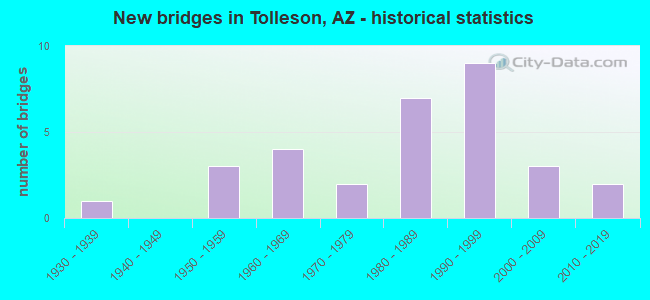
- New bridges - historical statistics
- 11930-1939
- 31950-1959
- 41960-1969
- 21970-1979
- 71980-1989
- 91990-1999
- 32000-2009
- 22010-2019
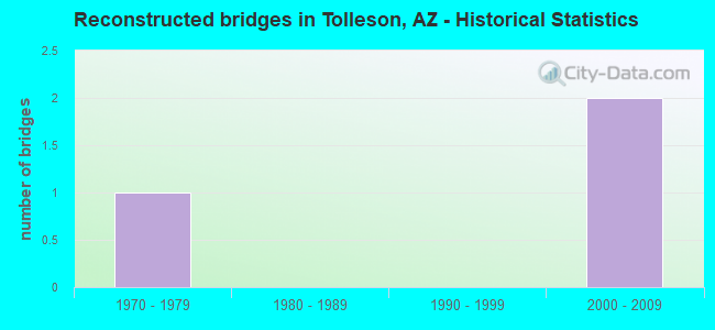
- Reconstructed bridges - Historical Statistics
- 11970-1979
- 01980-1989
- 01990-1999
- 22000-2009
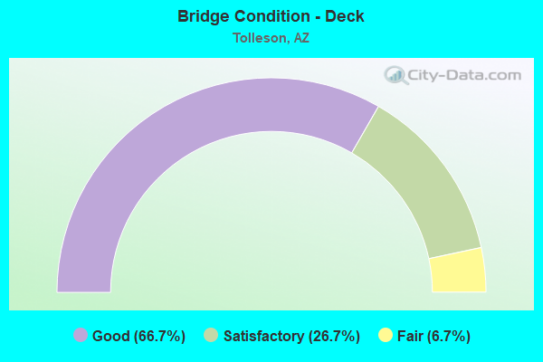
- Bridge Condition - Deck
- 66.7%Good
- 26.7%Satisfactory
- 6.7%Fair
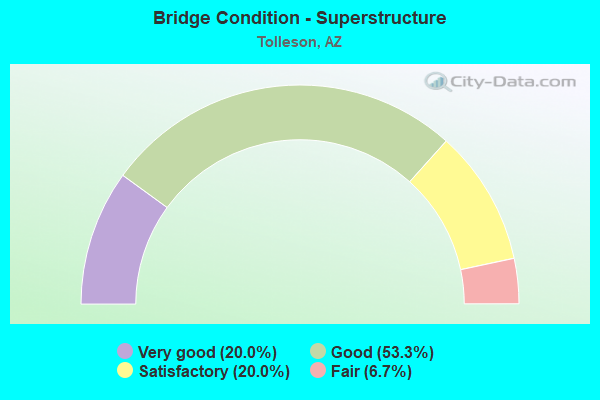
- Bridge Condition - Superstructure
- 20.0%Very good
- 53.3%Good
- 20.0%Satisfactory
- 6.7%Fair
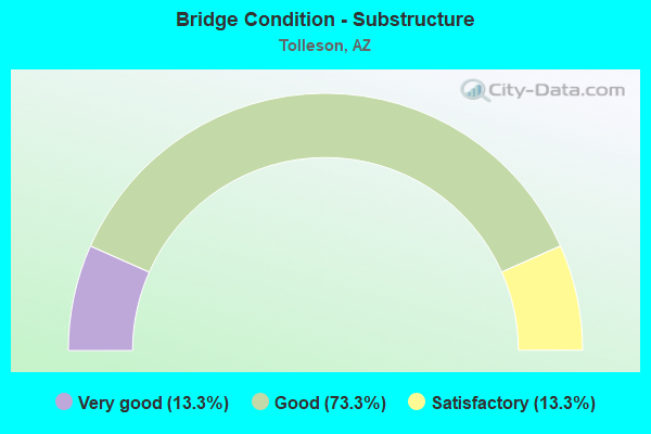
- Bridge Condition - Substructure
- 13.3%Very good
- 73.3%Good
- 13.3%Satisfactory
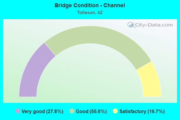
- Bridge Condition - Channel
- 27.8%Very good
- 55.6%Good
- 16.7%Satisfactory
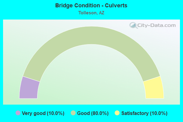
- Bridge Condition - Culverts
- 10.0%Very good
- 80.0%Good
- 10.0%Satisfactory
Find on map >> Show street view
Structure Number: 133, Location: 21.4 mi E Jct SR 89 (Lat: 34.729100, Lng: -112.147600), Route carried "on" structure: Alternate State highway 89, Year Built: 1935, Status: Open, Structure Length: 0.73m (2.40ft), Average Daily Traffic: 1,412 (year 2018), Truck Traffic: 9%, Average Future Daily Traffic: 1,422 (year 2040), Design Load: H 15, Features Intersected: Wash
Minimum Vertical Clearance: 30+ m (98+ ft), Kilometerpoint: 545.825, Lanes on structure: 2, Owner: State Highway Agency, Approaching Roadway Width: 8.8m (28.9ft), Skew: 1 degrees, Material/Design: Concrete, Design/Construction: Slab, Number Of Spans In Main Unit: 1, Length of Maximum Span: 6.7m (22.0ft), Curb-To-Curb Width: 9.0m (29.5ft), Out-to-Out Width: 10.0m (32.8ft)
Condition: Deck: Satisfactory, Superstructure: Satisfactory, Substructure: Satisfactory, Channel: Good, Operating Rating: 40.8 metric tons, Method Used To Determine Operating Rating: Load Factor (LF), Inventory Rating: 24.5 metric tons, Method Used To Determine Inventory Rating: Load Factor (LF), Structural Evaluation: Equal to present minimum criteria, Deck Geometry: Somewhat better than minimum adequacy, Waterway Adequacy: Equal to present minimum criteria, Approach Roadway Alignment: High priority of corrective action, Length Of Structure Improvement: 1.46m (4.79ft), Designated Inspection Frequency: Every 24 months, Inspection Date: July 2020, Total Project Cost: $1,000 ( Estimate for 2020), Deck Structure Type: Concrete Cast-file-Place, Wearing Surface/Protective System: Wearing Surface: Bituminous
Find on map >> Show street view
Structure Number: 756, Location: 6.9 mi W Jct US 95 (Lat: 33.646903, Lng: -114.335897), Route carried "on" structure: Interstate 10, Year Built: 1963, Status: Open, Structure Length: 2.74m (8.99ft), Average Daily Traffic: 10,246 (year 2018), Truck Traffic: 30%, Average Future Daily Traffic: 10,256 (year 2038), Design Load: HS 20, Features Intersected: Dome Rock Rd
Minimum Vertical Clearance: 30+ m (98+ ft), Kilometerpoint: 19.232, Lanes on structure: 2, Lanes under structure: 2, Owner: State Highway Agency, Approaching Roadway Width: 11.6m (38.1ft), Material/Design: Concrete continuous, Design/Construction: Slab, Number Of Spans In Main Unit: 3, Length of Maximum Span: 10.1m (33.1ft), Curb-To-Curb Width: 11.6m (38.1ft), Out-to-Out Width: 13.2m (43.3ft)
Condition: Deck: Good, Superstructure: Good, Substructure: Good, Operating Rating: 55.3 metric tons, Method Used To Determine Operating Rating: Load Factor (LF), Inventory Rating: 32.7 metric tons, Method Used To Determine Inventory Rating: Load Factor (LF), Structural Evaluation: Better than present minimum criteria, Deck Geometry: Equal to present minimum criteria, Underclear: Meets minimum limits, Approach Roadway Alignment: Better than present minimum criteria, Designated Inspection Frequency: Every 24 months, Inspection Date: Febuary 2020, Deck Structure Type: Concrete Cast-file-Place, Wearing Surface/Protective System: Wearing Surface: Bituminous
Find on map >> Show street view
Structure Number: 758, Location: 8.8 mi N Jct I-17 (Lat: 34.679100, Lng: -111.972800), Route carried "on" structure: State highway 260, Year Built: 1963, Status: Open, Structure Length: 5.61m (18.41ft), Average Daily Traffic: 8,557 (year 2018), Truck Traffic: 7%, Average Future Daily Traffic: 8,567 (year 2040), Design Load: HS 20, Features Intersected: Black Canyon Wash
Minimum Vertical Clearance: 30+ m (98+ ft), Kilometerpoint: 337.769, Lanes on structure: 2, Owner: State Highway Agency, Approaching Roadway Width: 12.2m (40.0ft), Skew: 2 degrees, Material/Design: Steel continuous, Design/Construction: Stringer/Multi-beam, Number Of Spans In Main Unit: 2, Length of Maximum Span: 27.4m (89.9ft), Curb-To-Curb Width: 9.1m (29.9ft), Out-to-Out Width: 10.7m (35.1ft)
Condition: Deck: Satisfactory, Superstructure: Good, Substructure: Satisfactory, Channel: Satisfactory, Operating Rating: 54.4 metric tons, Method Used To Determine Operating Rating: Load Factor (LF), Inventory Rating: 32.7 metric tons, Method Used To Determine Inventory Rating: Load Factor (LF), Structural Evaluation: Equal to present minimum criteria, Deck Geometry: Meets minimum limits, Waterway Adequacy: Equal to present desirable criteria, Approach Roadway Alignment: Equal to present desirable criteria, Designated Inspection Frequency: Every 24 months, Inspection Date: October 2020, Deck Structure Type: Concrete Cast-file-Place, Wearing Surface/Protective System: Wearing Surface: Bituminous
Find on map >> Show street view
Structure Number: 76, Location: 12.7 mi W Jct US 191 (Lat: 32.042700, Lng: -110.092700), Route carried "on" structure: Interstate 10, Year Built: 1963, Status: Open, Structure Length: 2.96m (9.71ft), Average Daily Traffic: 9,453 (year 2019), Truck Traffic: 38%, Average Future Daily Traffic: 9,463 (year 2039), Design Load: HS 20, Features Intersected: Dragoon Rd
Minimum Vertical Clearance: 30+ m (98+ ft), Kilometerpoint: 513.300, Lanes on structure: 2, Lanes under structure: 2, Owner: State Highway Agency, Approaching Roadway Width: 11.6m (38.1ft), Material/Design: Concrete continuous, Design/Construction: Slab, Number Of Spans In Main Unit: 3, Length of Maximum Span: 11.0m (36.1ft), Curb-To-Curb Width: 12.2m (40.0ft), Out-to-Out Width: 13.2m (43.3ft)
Condition: Deck: Fair, Superstructure: Fair, Substructure: Good, Operating Rating: 63.5 metric tons, Method Used To Determine Operating Rating: Load Factor (LF), Inventory Rating: 38.1 metric tons, Method Used To Determine Inventory Rating: Load Factor (LF), Structural Evaluation: Somewhat better than minimum adequacy, Deck Geometry: Better than present minimum criteria, Underclear: Meets minimum limits, Approach Roadway Alignment: Equal to present desirable criteria, Designated Inspection Frequency: Every 24 months, Inspection Date: January 2021, Deck Structure Type: Concrete Cast-file-Place, Wearing Surface/Protective System: Wearing Surface: Monolithic Concrete
Find on map >> Show street view
Structure Number: 761, Location: 12.7 mi W Jct US 191 (Lat: 32.042900, Lng: -110.092900), Route carried "on" structure: Interstate 10, Year Built: 1963, Status: Open, Structure Length: 2.96m (9.71ft), Average Daily Traffic: 8,880 (year 2019), Truck Traffic: 38%, Average Future Daily Traffic: 8,890 (year 2039), Design Load: HS 20+Mod, Features Intersected: Dragoon Rd
Minimum Vertical Clearance: 30+ m (98+ ft), Kilometerpoint: 513.300, Lanes on structure: 2, Lanes under structure: 2, Owner: State Highway Agency, Approaching Roadway Width: 11.6m (38.1ft), Material/Design: Concrete continuous, Design/Construction: Slab, Number Of Spans In Main Unit: 3, Length of Maximum Span: 11.0m (36.1ft), Curb-To-Curb Width: 12.2m (40.0ft), Out-to-Out Width: 13.2m (43.3ft)
Condition: Deck: Satisfactory, Superstructure: Satisfactory, Substructure: Good, Operating Rating: 63.5 metric tons, Method Used To Determine Operating Rating: Load Factor (LF), Inventory Rating: 38.1 metric tons, Method Used To Determine Inventory Rating: Load Factor (LF), Structural Evaluation: Equal to present minimum criteria, Deck Geometry: Better than present minimum criteria, Underclear: High priority of corrective action, Approach Roadway Alignment: Equal to present desirable criteria, Designated Inspection Frequency: Every 24 months, Inspection Date: January 2021, Deck Structure Type: Concrete Cast-file-Place, Wearing Surface/Protective System: Wearing Surface: Monolithic Concrete
Find on map >> Show street view
Structure Number: 1819, Location: 300 ft N Jct I-10 (Lat: 33.462800, Lng: -112.272500), Route carried "on" structure: ServiceState highway 10, Year Built: 1982, Status: Open, Structure Length: 2.47m (8.10ft), Average Daily Traffic: 31,300 (year 2015), Truck Traffic: 8%, Average Future Daily Traffic: 31,310 (year 2035), Design Load: HS 20, Features Intersected: Papago W Drain Channel, Facility Carried by Structure: 99th Avenue
Minimum Vertical Clearance: 30+ m (98+ ft), Kilometerpoint: 215.137, Lanes on structure: 7, Owner: State Highway Agency, Approaching Roadway Width: 28.7m (94.2ft), Skew: 20 degrees, Material/Design: Prestressed concrete, Design/Construction: Box Beam or Girders - Multiple, Number Of Spans In Main Unit: 1, Length of Maximum Span: 23.8m (78.1ft), Curb or Sidewalk Widths: Left: 2.2m (7.2ft), Right: 2.2m (7.2ft), Curb-To-Curb Width: 29.9m (98.1ft), Out-to-Out Width: 34.6m (113.5ft)
Condition: Deck: Satisfactory, Superstructure: Satisfactory, Substructure: Good, Channel: Very good, Operating Rating: 63.5 metric tons, Method Used To Determine Operating Rating: Load Factor (LF), Inventory Rating: 30.8 metric tons, Method Used To Determine Inventory Rating: Load Factor (LF), Structural Evaluation: Equal to present minimum criteria, Deck Geometry: Equal to present minimum criteria, Waterway Adequacy: Equal to present desirable criteria, Approach Roadway Alignment: Equal to present desirable criteria, Designated Inspection Frequency: Every 24 months, Inspection Date: Febuary 2021, Deck Structure Type: Concrete Cast-file-Place, Wearing Surface/Protective System: Wearing Surface: Bituminous
Find on map >> Show street view
Structure Number: 1821, Location: 0.1 mi North of Jct I 10 (Lat: 33.463394, Lng: -112.255247), Route carried "on" structure: ServiceState highway 10, Year Built: 1984, Status: Open, Structure Length: 2.68m (8.79ft), Average Daily Traffic: 20,400 (year 2017), Truck Traffic: 7%, Average Future Daily Traffic: 20,410 (year 2037), Design Load: HS 20, Features Intersected: Papago Drain Channel, Facility Carried by Structure: 91st Avenue
Minimum Vertical Clearance: 5.64m (18.50ft), Kilometerpoint: 216.730, Lanes on structure: 4, Owner: State Highway Agency, Approaching Roadway Width: 24.4m (80.1ft), Skew: 20 degrees, Material/Design: Prestressed concrete, Design/Construction: Stringer/Multi-beam, Number Of Spans In Main Unit: 1, Length of Maximum Span: 25.9m (85.0ft), Curb or Sidewalk Widths: Left: 1.8m (5.9ft), Right: 1.8m (5.9ft), Curb-To-Curb Width: 24.4m (80.1ft), Out-to-Out Width: 29.5m (96.8ft)
Condition: Deck: Good, Superstructure: Very good, Substructure: Very good, Channel: Good, Operating Rating: 89.8 metric tons, Method Used To Determine Operating Rating: Load Factor (LF), Inventory Rating: 37.2 metric tons, Method Used To Determine Inventory Rating: Load Factor (LF), Structural Evaluation: Equal to present desirable criteria, Deck Geometry: Superior to present desirable criteria, Waterway Adequacy: Equal to present desirable criteria, Approach Roadway Alignment: Equal to present desirable criteria, Designated Inspection Frequency: Every 24 months, Inspection Date: March 2021, Deck Structure Type: Concrete Cast-file-Place, Wearing Surface/Protective System: Wearing Surface: Monolithic Concrete
Find on map >> Show street view
Structure Number: 2202, Location: Jct SR L101 (Lat: 33.461200, Lng: -112.266600), Route carried "on" structure: Ramp State highway 101, Year Built: 1998, Status: Open, Structure Length: 29.81m (97.80ft), Average Daily Traffic: 60,668 (year 2015), Truck Traffic: 6%, Average Future Daily Traffic: 60,678 (year 2035), Design Load: HS 20, Features Intersected: Rmp 99D/ I-10 /N Con Rd/, Facility Carried by Structure: Ramp S - E
Minimum Vertical Clearance: 5.51m (18.08ft), Kilometerpoint: 2.350, Lanes on structure: 2, Lanes under structure: 14, Owner: State Highway Agency, Approaching Roadway Width: 11.0m (36.1ft), Material/Design: Prestressed concrete continuous, Design/Construction: Box Beam or Girders - Single/Spread, Number Of Spans In Main Unit: 6, Length of Maximum Span: 62.5m (205.1ft), Curb-To-Curb Width: 11.0m (36.1ft), Out-to-Out Width: 11.9m (39.0ft)
Condition: Deck: Good, Superstructure: Good, Substructure: Good, Channel: Very good, Operating Rating: 76.2 metric tons, Method Used To Determine Operating Rating: Load Factor (LF), Inventory Rating: 46.3 metric tons, Method Used To Determine Inventory Rating: Load Factor (LF), Structural Evaluation: Better than present minimum criteria, Deck Geometry: Better than present minimum criteria, Underclear: High priority of corrective action, Waterway Adequacy: Equal to present desirable criteria, Approach Roadway Alignment: Equal to present desirable criteria, Designated Inspection Frequency: Every 24 months, Inspection Date: Febuary 2021, Deck Structure Type: Concrete Cast-file-Place, Wearing Surface/Protective System: Wearing Surface: Bituminous
Find on map >> Show street view
Structure Number: 2203, Location: South of I 10 / E of 99 (Lat: 33.461653, Lng: -112.269456), Route carried "on" structure: Ramp State highway 101, Year Built: 1998, Status: Open, Structure Length: 75.68m (248.29ft), Average Daily Traffic: 23,942 (year 2018), Truck Traffic: 4%, Average Future Daily Traffic: 23,952 (year 2038), Design Load: HS 20, Features Intersected: I 10, McDowell & Rp 99C, Facility Carried by Structure: Ramp E - N
Minimum Vertical Clearance: 30+ m (98+ ft), Kilometerpoint: 3.220, Lanes on structure: 2, Lanes under structure: 30, Owner: State Highway Agency, Approaching Roadway Width: 8.5m (27.9ft), Material/Design: Prestressed concrete continuous, Design/Construction: Box Beam or Girders - Single/Spread, Number Of Spans In Main Unit: 18, Length of Maximum Span: 50.0m (164.0ft), Curb-To-Curb Width: 8.5m (27.9ft), Out-to-Out Width: 9.5m (31.2ft)
Condition: Deck: Good, Superstructure: Good, Substructure: Good, Channel: Good, Operating Rating: 73.5 metric tons, Method Used To Determine Operating Rating: Load Factor (LF), Inventory Rating: 43.5 metric tons, Method Used To Determine Inventory Rating: Load Factor (LF), Structural Evaluation: Better than present minimum criteria, Deck Geometry: High priority of corrective action, Underclear: High priority of corrective action, Waterway Adequacy: Equal to present desirable criteria, Approach Roadway Alignment: Equal to present desirable criteria, Designated Inspection Frequency: Every 24 months, Inspection Date: Febuary 2021, Deck Structure Type: Concrete Cast-file-Place, Wearing Surface/Protective System: Wearing Surface: Bituminous
Find on map >> Show street view
Structure Number: 2204, Location: 2nd Level NE Corner TI (Lat: 33.462200, Lng: -112.265650), Route carried "on" structure: Ramp Interstate 10, Year Built: 1998, Status: Open, Structure Length: 23.04m (75.59ft), Average Daily Traffic: 20,040 (year 2015), Truck Traffic: 7%, Average Future Daily Traffic: 20,050 (year 2035), Design Load: HS 20, Features Intersected: N Connector Rd/I 10 Drng, Facility Carried by Structure: Ramp W - N
Minimum Vertical Clearance: 30+ m (98+ ft), Kilometerpoint: 215.781, Lanes on structure: 2, Lanes under structure: 2, Owner: State Highway Agency, Approaching Roadway Width: 11.0m (36.1ft), Material/Design: Prestressed concrete continuous, Design/Construction: Box Beam or Girders - Single/Spread, Number Of Spans In Main Unit: 4, Length of Maximum Span: 62.5m (205.1ft), Curb-To-Curb Width: 11.0m (36.1ft), Out-to-Out Width: 11.9m (39.0ft)
Condition: Deck: Good, Superstructure: Good, Substructure: Good, Channel: Good, Operating Rating: 79.8 metric tons, Method Used To Determine Operating Rating: Load Factor (LF), Inventory Rating: 47.2 metric tons, Method Used To Determine Inventory Rating: Load Factor (LF), Structural Evaluation: Better than present minimum criteria, Deck Geometry: Better than present minimum criteria, Underclear: Superior to present desirable criteria, Waterway Adequacy: Equal to present desirable criteria, Approach Roadway Alignment: Equal to present desirable criteria, Designated Inspection Frequency: Every 24 months, Inspection Date: Febuary 2021, Deck Structure Type: Concrete Cast-file-Place, Wearing Surface/Protective System: Wearing Surface: Bituminous
Find on map >> Show street view
Structure Number: 2205, Location: Jct SR L101 (Lat: 33.461200, Lng: -112.269000), Route carried "on" structure: Ramp Interstate 10, Year Built: 1998, Status: Open, Structure Length: 4.54m (14.90ft), Average Daily Traffic: 40,080 (year 2015), Truck Traffic: 11%, Average Future Daily Traffic: 40,090 (year 2039), Design Load: HS 20, Features Intersected: Ramp 99D, Facility Carried by Structure: Ramp 91B
Minimum Vertical Clearance: 30+ m (98+ ft), Kilometerpoint: 215.443, Lanes on structure: 1, Lanes under structure: 1, Owner: State Highway Agency, Approaching Roadway Width: 7.9m (25.9ft), Material/Design: Prestressed concrete, Design/Construction: Box Beam or Girders - Single/Spread, Number Of Spans In Main Unit: 1, Length of Maximum Span: 44.2m (145.0ft), Curb-To-Curb Width: 7.9m (25.9ft), Out-to-Out Width: 8.9m (29.2ft)
Condition: Deck: Good, Superstructure: Good, Substructure: Good, Operating Rating: 78.0 metric tons, Method Used To Determine Operating Rating: Load Factor (LF), Inventory Rating: 38.1 metric tons, Method Used To Determine Inventory Rating: Load Factor (LF), Structural Evaluation: Better than present minimum criteria, Deck Geometry: Equal to present desirable criteria, Underclear: High priority of corrective action, Approach Roadway Alignment: Equal to present desirable criteria, Designated Inspection Frequency: Every 24 months, Inspection Date: Febuary 2021, Deck Structure Type: Concrete Cast-file-Place, Wearing Surface/Protective System: Wearing Surface: Monolithic Concrete
Find on map >> Show street view
Structure Number: 2206, Location: 1.0 mi North of I 10 (Lat: 33.464600, Lng: -112.268900), Route carried "on" structure: Ramp State highway 101, Year Built: 2000, Status: Open, Structure Length: 5.85m (19.19ft), Average Daily Traffic: 134,044 (year 2019), Truck Traffic: 6%, Average Future Daily Traffic: 182,999 (year 2040), Design Load: HS 20, Features Intersected: RID Canal & McDowell Rd
Minimum Vertical Clearance: 30+ m (98+ ft), Kilometerpoint: 2.334, Lanes on structure: 3, Lanes under structure: 6, Owner: State Highway Agency, Approaching Roadway Width: 17.7m (58.1ft), Skew: 10 degrees, Material/Design: Prestressed concrete continuous, Design/Construction: Box Beam or Girders - Single/Spread, Number Of Spans In Main Unit: 2, Length of Maximum Span: 31.4m (103.0ft), Curb-To-Curb Width: 17.6m (57.7ft), Out-to-Out Width: 18.5m (60.7ft)
Condition: Deck: Good, Superstructure: Good, Substructure: Good, Operating Rating: 74.4 metric tons, Method Used To Determine Operating Rating: Load Factor (LF), Inventory Rating: 44.5 metric tons, Method Used To Determine Inventory Rating: Load Factor (LF), Structural Evaluation: Better than present minimum criteria, Deck Geometry: Superior to present desirable criteria, Underclear: Meets minimum limits, Approach Roadway Alignment: Equal to present desirable criteria, Designated Inspection Frequency: Every 24 months, Inspection Date: April 2021, Deck Structure Type: Concrete Cast-file-Place, Wearing Surface/Protective System: Wearing Surface: Bituminous
Find on map >> Show street view
Structure Number: 2573, Location: 3.55 mi S US60 (Lat: 33.335500, Lng: -111.646000), Route carried "on" structure: Ramp State highway 202, Year Built: 2014, Status: Open, Structure Length: 6.98m (22.90ft), Average Daily Traffic: 4,000 (year 2020), Truck Traffic: 7%, Average Future Daily Traffic: 4,010 (year 2040), Design Load: HL 93, Features Intersected: Warner Road, Facility Carried by Structure: Ramp N-E
Minimum Vertical Clearance: 30+ m (98+ ft), Kilometerpoint: 54.959, Lanes on structure: 1, Lanes under structure: 2, Owner: State Highway Agency, Approaching Roadway Width: 12.2m (40.0ft), Material/Design: Prestressed concrete continuous, Design/Construction: Box Beam or Girders - Single/Spread, Number Of Spans In Main Unit: 2, Length of Maximum Span: 34.1m (111.9ft), Curb-To-Curb Width: 12.2m (40.0ft), Out-to-Out Width: 13.2m (43.3ft)
Condition: Deck: Good, Superstructure: Good, Substructure: Good, Operating Rating: 89.8 metric tons, Method Used To Determine Operating Rating: Load Factor (LF), Inventory Rating: 83.5 metric tons, Method Used To Determine Inventory Rating: Load Factor (LF), Structural Evaluation: Better than present minimum criteria, Deck Geometry: Superior to present desirable criteria, Underclear: Superior to present desirable criteria, Approach Roadway Alignment: Equal to present desirable criteria, Designated Inspection Frequency: Every 24 months, Inspection Date: August 2020, Deck Structure Type: Concrete Cast-file-Place, Wearing Surface/Protective System: Wearing Surface: Monolithic Concrete
Find on map >> Show street view
Structure Number: 2622, Location: 36.4 mi S Jct I-40 (Lat: 34.655200, Lng: -113.575100), Route carried "on" structure: US 93, Year Built: 2003, Status: Open, Structure Length: 9.27m (30.41ft), Average Daily Traffic: 3,346 (year 2017), Truck Traffic: 15%, Average Future Daily Traffic: 3,356 (year 2038), Design Load: HS 20, Features Intersected: Sycamore Creek
Minimum Vertical Clearance: 30+ m (98+ ft), Kilometerpoint: 205.401, Lanes on structure: 2, Owner: State Highway Agency, Approaching Roadway Width: 11.6m (38.1ft), Material/Design: Prestressed concrete continuous, Design/Construction: Stringer/Multi-beam, Number Of Spans In Main Unit: 3, Length of Maximum Span: 30.5m (100.1ft), Curb-To-Curb Width: 12.8m (42.0ft), Out-to-Out Width: 13.7m (44.9ft)
Condition: Deck: Good, Superstructure: Very good, Substructure: Good, Channel: Good, Operating Rating: 89.8 metric tons, Method Used To Determine Operating Rating: Load Factor (LF), Inventory Rating: 41.7 metric tons, Method Used To Determine Inventory Rating: Load Factor (LF), Structural Evaluation: Better than present minimum criteria, Deck Geometry: Equal to present desirable criteria, Waterway Adequacy: Equal to present desirable criteria, Approach Roadway Alignment: Equal to present desirable criteria, Designated Inspection Frequency: Every 24 months, Inspection Date: December 2020, Deck Structure Type: Concrete Cast-file-Place, Wearing Surface/Protective System: Wearing Surface: Monolithic Concrete
Find on map >> Show street view
Structure Number: 2936, Location: 17.3 mi S Jct I-40 (Lat: 34.942000, Lng: -111.653200), Route carried "on" structure: Interstate 17, Year Built: 2011, Status: Open, Structure Length: 2.93m (9.61ft), Average Daily Traffic: 8,874 (year 2017), Truck Traffic: 24%, Average Future Daily Traffic: 8,884 (year 2038), Design Load: HL 93, Features Intersected: Pinewood Blvd
Minimum Vertical Clearance: 30+ m (98+ ft), Kilometerpoint: 519.367, Lanes on structure: 2, Lanes under structure: 3, Base Highway Network: Yes, Owner: State Highway Agency, Approaching Roadway Width: 18.9m (62.0ft), Skew: 1 degrees, Material/Design: Prestressed concrete, Design/Construction: Box Beam or Girders - Multiple, Number Of Spans In Main Unit: 1, Length of Maximum Span: 27.4m (89.9ft), Curb-To-Curb Width: 18.9m (62.0ft), Out-to-Out Width: 19.8m (65.0ft)
Condition: Deck: Good, Superstructure: Very good, Substructure: Very good, Operating Rating: 89.8 metric tons, Method Used To Determine Operating Rating: Load Factor (LF), Inventory Rating: 44.5 metric tons, Method Used To Determine Inventory Rating: Load Factor (LF), Structural Evaluation: Equal to present desirable criteria, Deck Geometry: Superior to present desirable criteria, Underclear: Superior to present desirable criteria, Approach Roadway Alignment: Equal to present desirable criteria, Designated Inspection Frequency: Every 24 months, Inspection Date: July 2020, Deck Structure Type: Concrete Cast-file-Place, Wearing Surface/Protective System: Wearing Surface: Monolithic Concrete, Deck Protection: Epoxy Coated Reinforcing
Find on map >> Show street view
Structure Number: 4944, Location: 5.1 mi S Jct W/ I 40 (Lat: 35.095600, Lng: -113.665700), Route carried "on" structure: US 93, Year Built: 1957, Status: Open, Structure Length: 0.76m (2.49ft), Average Daily Traffic: 4,793 (year 2015), Truck Traffic: 19%, Average Future Daily Traffic: 4,803 (year 2037), Design Load: HS 20, Features Intersected: Wash
Minimum Vertical Clearance: 30+ m (98+ ft), Kilometerpoint: 155.110, Lanes on structure: 2, Owner: State Highway Agency, Approaching Roadway Width: 8.8m (28.9ft), Material/Design: Concrete continuous, Design/Construction: Culvert, Number Of Spans In Main Unit: 2, Length of Maximum Span: 3.7m (12.1ft)
Condition: Channel: Satisfactory, Culverts: Good, Operating Rating: 89.8 metric tons, Method Used To Determine Operating Rating: Load Factor (LF), Inventory Rating: 79.8 metric tons, Method Used To Determine Inventory Rating: Load Factor (LF), Structural Evaluation: Better than present minimum criteria, Waterway Adequacy: Equal to present desirable criteria, Approach Roadway Alignment: Equal to present desirable criteria, Designated Inspection Frequency: Every 48 months, Inspection Date: May 2021
Find on map >> Show street view
Structure Number: 4945, Location: 7.5 mi S Jct W/ I 40 (Lat: 35.060300, Lng: -113.664900), Route carried "on" structure: US 93, Year Built: 1957, Status: Open, Structure Length: 1.31m (4.30ft), Average Daily Traffic: 4,793 (year 2019), Truck Traffic: 19%, Average Future Daily Traffic: 4,803 (year 2039), Design Load: HS 20, Features Intersected: Wash
Minimum Vertical Clearance: 30+ m (98+ ft), Kilometerpoint: 158.890, Lanes on structure: 2, Owner: State Highway Agency, Approaching Roadway Width: 8.8m (28.9ft), Material/Design: Concrete continuous, Design/Construction: Culvert, Number Of Spans In Main Unit: 4, Length of Maximum Span: 3.0m (9.8ft)
Condition: Channel: Good, Culverts: Good, Operating Rating: 63.5 metric tons, Method Used To Determine Operating Rating: Load Factor (LF), Inventory Rating: 38.1 metric tons, Method Used To Determine Inventory Rating: Load Factor (LF), Structural Evaluation: Better than present minimum criteria, Waterway Adequacy: Equal to present desirable criteria, Approach Roadway Alignment: Equal to present desirable criteria, Designated Inspection Frequency: Every 48 months, Inspection Date: May 2021
Find on map >> Show street view
Structure Number: 5945, Location: 8.9 mi W Jct SR 99 (Lat: 35.101614, Lng: -110.986461), Route carried "on" structure: Interstate 40, Year Built: 1950, Year Reconstructed: 1970, Status: Open, Structure Length: 0.64m (2.10ft), Average Daily Traffic: 18,593 (year 2017), Truck Traffic: 24%, Average Future Daily Traffic: 18,603 (year 2039), Design Load: HS 20, Features Intersected: Cow Canyon
Minimum Vertical Clearance: 30+ m (98+ ft), Kilometerpoint: 380.529, Lanes on structure: 4, Owner: State Highway Agency, Approaching Roadway Width: 23.2m (76.1ft), Skew: 20 degrees, Material/Design: Concrete continuous, Design/Construction: Culvert, Number Of Spans In Main Unit: 2, Length of Maximum Span: 3.0m (9.8ft)
Condition: Channel: Good, Culverts: Good, Operating Rating: 89.8 metric tons, Method Used To Determine Operating Rating: Load Factor (LF), Inventory Rating: 89.8 metric tons, Method Used To Determine Inventory Rating: Load Factor (LF), Structural Evaluation: Better than present minimum criteria, Waterway Adequacy: Equal to present desirable criteria, Approach Roadway Alignment: Equal to present desirable criteria, Designated Inspection Frequency: Every 48 months, Inspection Date: April 2019
Find on map >> Show street view
Structure Number: 6132, Location: 9.8 mi S Jct SR 90 (Lat: 31.418111, Lng: -110.240750), Route carried "on" structure: State highway 92, Year Built: 1970, Year Reconstructed: 2012, Status: Open, Structure Length: 0.73m (2.40ft), Average Daily Traffic: 4,931 (year 2018), Truck Traffic: 2%, Average Future Daily Traffic: 4,941 (year 2038), Design Load: HS 20, Features Intersected: Wash
Minimum Vertical Clearance: 30+ m (98+ ft), Kilometerpoint: 532.661, Lanes on structure: 5, Owner: State Highway Agency, Approaching Roadway Width: 25.0m (82.0ft), Skew: 3 degrees, Material/Design: Concrete continuous, Design/Construction: Culvert, Number Of Spans In Main Unit: 2, Length of Maximum Span: 3.0m (9.8ft)
Condition: Channel: Very good, Culverts: Good, Operating Rating: 89.8 metric tons, Method Used To Determine Operating Rating: Load Factor (LF), Inventory Rating: 89.8 metric tons, Method Used To Determine Inventory Rating: Load Factor (LF), Structural Evaluation: Better than present minimum criteria, Waterway Adequacy: Superior to present desirable criteria, Approach Roadway Alignment: Equal to present desirable criteria, Length Of Structure Improvement: 1.46m (4.79ft), Designated Inspection Frequency: Every 48 months, Inspection Date: June 2020
Find on map >> Show street view
Structure Number: 6133, Location: 10.0 mi S Jct SR 90 (Lat: 31.414700, Lng: -110.240800), Route carried "on" structure: State highway 92, Year Built: 1971, Year Reconstructed: 2012, Status: Open, Structure Length: 0.73m (2.40ft), Average Daily Traffic: 4,931 (year 2018), Truck Traffic: 2%, Average Future Daily Traffic: 4,941 (year 2038), Design Load: HS 20, Features Intersected: Wash
Minimum Vertical Clearance: 30+ m (98+ ft), Kilometerpoint: 533.063, Lanes on structure: 5, Owner: State Highway Agency, Approaching Roadway Width: 25.0m (82.0ft), Skew: 3 degrees, Material/Design: Concrete continuous, Design/Construction: Culvert, Number Of Spans In Main Unit: 2, Length of Maximum Span: 3.0m (9.8ft)
Condition: Channel: Good, Culverts: Good, Operating Rating: 89.8 metric tons, Method Used To Determine Operating Rating: Load Factor (LF), Inventory Rating: 89.8 metric tons, Method Used To Determine Inventory Rating: Load Factor (LF), Structural Evaluation: Better than present minimum criteria, Waterway Adequacy: Equal to present desirable criteria, Approach Roadway Alignment: Equal to present desirable criteria, Length Of Structure Improvement: 5.58m (18.31ft), Designated Inspection Frequency: Every 48 months, Inspection Date: June 2020
Find on map >> Show street view
Structure Number: 6789, Location: 8.2 mi West of Jct I 17 (Lat: 33.462528, Lng: -112.250861), Route carried "on" structure: Interstate 10, Year Built: 1984, Status: Open, Structure Length: 0.98m (3.22ft), Average Daily Traffic: 250,784 (year 2017), Truck Traffic: 7%, Average Future Daily Traffic: 250,794 (year 2037), Design Load: HS 20, Features Intersected: RID Canal & dr. channel
Minimum Vertical Clearance: 30+ m (98+ ft), Kilometerpoint: 217.245, Lanes on structure: 15, Owner: State Highway Agency, Approaching Roadway Width: 46.3m (151.9ft), Material/Design: Concrete continuous, Design/Construction: Culvert, Number Of Spans In Main Unit: 3, Length of Maximum Span: 3.0m (9.8ft)
Condition: Channel: Very good, Culverts: Very good, Operating Rating: 89.8 metric tons, Method Used To Determine Operating Rating: Load Factor (LF), Inventory Rating: 89.8 metric tons, Method Used To Determine Inventory Rating: Load Factor (LF), Structural Evaluation: Equal to present desirable criteria, Waterway Adequacy: Equal to present desirable criteria, Approach Roadway Alignment: Equal to present desirable criteria, Length Of Structure Improvement: 1.74m (5.71ft), Designated Inspection Frequency: Every 48 months, Inspection Date: Febuary 2019, Bridge Improvement Cost: $2,000, Roadway Improvement Cost: $1,000, Total Project Cost: $4,000 ( Estimate for 2014)
Find on map >> Show street view
Structure Number: 679, Location: 0.1 mi North of Jct I 10 (Lat: 33.463250, Lng: -112.250889), Route carried "on" structure: ServiceOther road 10, Year Built: 1983, Status: Open, Structure Length: 3.17m (10.40ft), Average Daily Traffic: 10 (year 2013), Average Future Daily Traffic: 20 (year 2033), Design Load: HS 20, Features Intersected: Papago drain, Facility Carried by Structure: Frontage Rd.
Minimum Vertical Clearance: 30+ m (98+ ft), Kilometerpoint: 217.149, Lanes on structure: 2, Owner: State Highway Agency, Approaching Roadway Width: 9.8m (32.2ft), Material/Design: Concrete continuous, Design/Construction: Culvert, Number Of Spans In Main Unit: 8, Length of Maximum Span: 3.7m (12.1ft)
Condition: Channel: Very good, Culverts: Satisfactory, Operating Rating: 89.8 metric tons, Method Used To Determine Operating Rating: Load Factor (LF), Inventory Rating: 89.8 metric tons, Method Used To Determine Inventory Rating: Load Factor (LF), Structural Evaluation: Equal to present minimum criteria, Waterway Adequacy: Equal to present desirable criteria, Approach Roadway Alignment: Equal to present desirable criteria, Designated Inspection Frequency: Every 48 months, Inspection Date: Febuary 2019
Find on map >> Show street view
Structure Number: 7016, Location: 19.2 mi NW Jct SR 68 (Lat: 35.457200, Lng: -114.302400), Route carried "on" structure: US 93, Year Built: 1992, Status: Open, Structure Length: 0.98m (3.22ft), Average Daily Traffic: 15,157 (year 2017), Truck Traffic: 7%, Average Future Daily Traffic: 15,167 (year 2037), Design Load: HS 20, Features Intersected: Wash
Minimum Vertical Clearance: 30+ m (98+ ft), Kilometerpoint: 77.120, Lanes on structure: 4, Owner: State Highway Agency, Approaching Roadway Width: 20.1m (65.9ft), Skew: 20 degrees, Material/Design: Concrete continuous, Design/Construction: Culvert, Number Of Spans In Main Unit: 5, Length of Maximum Span: 1.8m (5.9ft)
Condition: Channel: Good, Culverts: Good, Operating Rating: 89.8 metric tons, Method Used To Determine Operating Rating: Load Factor (LF), Inventory Rating: 89.8 metric tons, Method Used To Determine Inventory Rating: Load Factor (LF), Structural Evaluation: Better than present minimum criteria, Waterway Adequacy: Equal to present desirable criteria, Approach Roadway Alignment: Equal to present desirable criteria, Designated Inspection Frequency: Every 48 months, Inspection Date: October 2018
Find on map >> Show street view
Structure Number: 757, Location: 0.6 mi N River Road (Lat: 32.292281, Lng: -110.925931), Route carried "on" structure: County highway , Year Built: 1988, Status: Open, Structure Length: 0.82m (2.69ft), Average Daily Traffic: 2,200 (year 2012), Average Future Daily Traffic: 2,210 (year 2030), Design Load: HS 20, Features Intersected: Small Wash, Facility Carried by Structure: Hacienda Del Sol
Minimum Vertical Clearance: 30+ m (98+ ft), Kilometerpoint: 0.000, Lanes on structure: 2, Owner: County Highway Agency, Approaching Roadway Width: 9.8m (32.2ft), Skew: 2 degrees, Material/Design: Steel, Design/Construction: Culvert, Number Of Spans In Main Unit: 3, Length of Maximum Span: 1.8m (5.9ft)
Condition: Channel: Satisfactory, Culverts: Good, Inventory Rating: 85.3 metric tons, Method Used To Determine Inventory Rating: Load Factor (LF), Structural Evaluation: Better than present minimum criteria, Waterway Adequacy: Better than present minimum criteria, Approach Roadway Alignment: Equal to present desirable criteria, Designated Inspection Frequency: Every 48 months, Inspection Date: November 2019
Find on map >> Show street view
Structure Number: 9926, Location: 0.2 mi W Jct 83rd Ave (Lat: 33.451447, Lng: -112.242681), Route carried "on" structure: City street , Year Built: 1987, Status: Open, Structure Length: 0.64m (2.10ft), Average Daily Traffic: 12,114 (year 2020), Truck Traffic: 5%, Average Future Daily Traffic: 12,124 (year 2040), Design Load: HS 20, Features Intersected: RID Canal, Facility Carried by Structure: Van Buren Street
Minimum Vertical Clearance: 30+ m (98+ ft), Kilometerpoint: 0.000, Lanes on structure: 5, Owner: Town or Township Highway Agency, Approaching Roadway Width: 18.3m (60.0ft), Material/Design: Concrete continuous, Design/Construction: Culvert, Number Of Spans In Main Unit: 2, Length of Maximum Span: 3.0m (9.8ft), Curb-To-Curb Width: 18.3m (60.0ft), Out-to-Out Width: 25.0m (82.0ft)
Condition: Channel: Good, Culverts: Good, Operating Rating: 53.5 metric tons, Method Used To Determine Operating Rating: Load Factor (LF), Inventory Rating: 31.8 metric tons, Method Used To Determine Inventory Rating: Load Factor (LF), Structural Evaluation: Better than present minimum criteria, Deck Geometry: High priority of replacement, Waterway Adequacy: Equal to present minimum criteria, Approach Roadway Alignment: Equal to present desirable criteria, Designated Inspection Frequency: Every 24 months, Inspection Date: May 2021, Deck Structure Type: Concrete Cast-file-Place, Wearing Surface/Protective System: Wearing Surface: Bituminous
Find on map >> Show street view
Structure Number: 182, Location: 8.4 mi West Jct I 17 (Lat: 33.461900, Lng: -112.255300), Route carried "under" structure: Interstate 10, Year Built: 1984, Structure Length: 0. m, Average Daily Traffic: 232,388 (year 2019), Truck Traffic: 8%, Features Intersected: I 10, Facility Carried by Structure: 91st Avenue
Minimum Vertical Clearance: 5.18m (16.99ft), Kilometerpoint: 216.730, Lanes on structure: 6, Lanes under structure: 12, Material/Design: Prestressed concrete continuous, Design/Construction: Box Beam or Girders - Single/Spread, Length of Maximum Span: 47.5m (155.8ft)
Find on map >> Show street view
Structure Number: 2202, Location: Jct SR L101 (Lat: 33.461200, Lng: -112.266600), Route carried "under" structure: Interstate 10, Year Built: 1998, Structure Length: 0. m, Average Daily Traffic: 239,423 (year 2017), Truck Traffic: 4%, Features Intersected: Rmp 99D/ I-10 /N Con Rd/, Facility Carried by Structure: Ramp S - E
Minimum Vertical Clearance: 5.79m (19.00ft), Kilometerpoint: 215.652, Lanes on structure: 2, Lanes under structure: 14, Material/Design: Prestressed concrete continuous, Design/Construction: Box Beam or Girders - Single/Spread, Length of Maximum Span: 62.5m (205.1ft)
Find on map >> Show street view
Structure Number: 2203, Location: South of I 10 / E of 99 (Lat: 33.461653, Lng: -112.269456), Route carried "under" structure: Interstate 10, Year Built: 1998, Structure Length: 0. m, Average Daily Traffic: 248,042 (year 2018), Truck Traffic: 9%, Features Intersected: I 10, McDowell & Rp 99C, Facility Carried by Structure: Ramp E - N
Minimum Vertical Clearance: 5.51m (18.08ft), Kilometerpoint: 215.427, Lanes on structure: 2, Lanes under structure: 1, Material/Design: Prestressed concrete continuous, Design/Construction: Box Beam or Girders - Single/Spread, Length of Maximum Span: 50.0m (164.0ft)
Find on map >> Show street view
Structure Number: 2204, Location: 2nd Level NE Corner TI (Lat: 33.462200, Lng: -112.265650), Route carried "under" structure: Ramp Interstate 10, Year Built: 1998, Structure Length: 0. m, Average Daily Traffic: 1,184 (year 2012), Truck Traffic: 5%, Features Intersected: N Connector Rd/I 10 Drng, Facility Carried by Structure: Ramp W - N
Minimum Vertical Clearance: 5.93m (19.46ft), Kilometerpoint: 0.000, Lanes on structure: 2, Lanes under structure: 2, Material/Design: Prestressed concrete continuous, Design/Construction: Box Beam or Girders - Single/Spread, Length of Maximum Span: 62.5m (205.1ft)
Find on map >> Show street view
Structure Number: 2205, Location: Jct SR L101 (Lat: 33.461200, Lng: -112.269000), Route carried "under" structure: Ramp Interstate 10, Year Built: 1998, Structure Length: 0. m, Average Daily Traffic: 2,620 (year 2015), Truck Traffic: 7%, Features Intersected: Ramp 99D, Facility Carried by Structure: Ramp 91B
Minimum Vertical Clearance: 5.03m (16.50ft), Kilometerpoint: 215.443, Lanes on structure: 1, Lanes under structure: 1, Material/Design: Prestressed concrete, Design/Construction: Box Beam or Girders - Single/Spread, Length of Maximum Span: 44.2m (145.0ft)
Find on map >> Show street view
Structure Number: 2206, Location: 1.0 mi North of I 10 (Lat: 33.464600, Lng: -112.268900), Route carried "under" structure: City street , Year Built: 2000, Structure Length: 0. m, Average Daily Traffic: 31,300 (year 2015), Truck Traffic: 3%, Features Intersected: RID Canal & McDowell Rd, Facility Carried by Structure: Loop 101 SB Ramp
Minimum Vertical Clearance: 6.23m (20.44ft), Kilometerpoint: 0.000, Lanes on structure: 3, Lanes under structure: 3, Material/Design: Prestressed concrete continuous, Design/Construction: Box Beam or Girders - Single/Spread, Length of Maximum Span: 31.4m (103.0ft)