Bridge Statistics for Urbana, Illinois (IL)
Condition, Traffic, Stress, Structural Evaluation, Project Costs
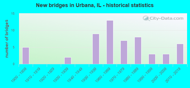
- New bridges - historical statistics
- 51900-1909
- 21930-1939
- 91950-1959
- 131960-1969
- 71970-1979
- 81980-1989
- 31990-1999
- 32000-2009
- 62010-2019
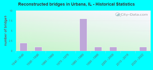
- Reconstructed bridges - Historical Statistics
- 21940-1949
- 11950-1959
- 01960-1969
- 01970-1979
- 81980-1989
- 11990-1999
- 12000-2009
- 02010-2019
- 12020-2022
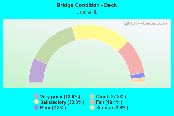
- Bridge Condition - Deck
- 13.9%Very good
- 27.8%Good
- 33.3%Satisfactory
- 19.4%Fair
- 2.8%Poor
- 2.8%Serious
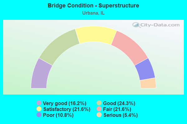
- Bridge Condition - Superstructure
- 16.2%Very good
- 24.3%Good
- 21.6%Satisfactory
- 21.6%Fair
- 10.8%Poor
- 5.4%Serious
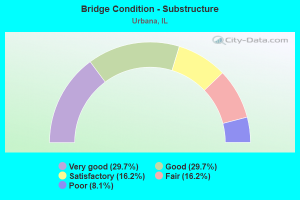
- Bridge Condition - Substructure
- 29.7%Very good
- 29.7%Good
- 16.2%Satisfactory
- 16.2%Fair
- 8.1%Poor
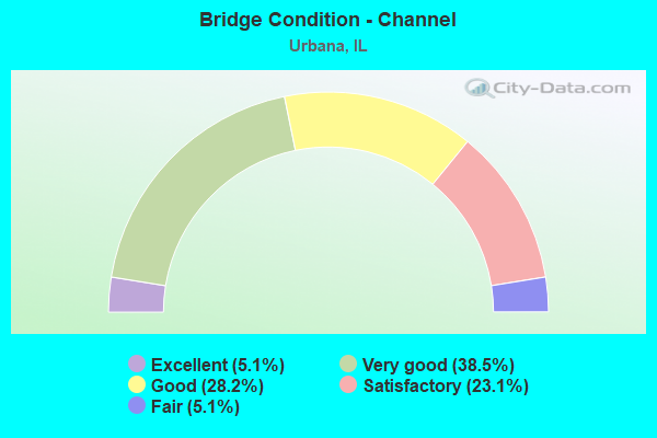
- Bridge Condition - Channel
- 5.1%Excellent
- 38.5%Very good
- 28.2%Good
- 23.1%Satisfactory
- 5.1%Fair
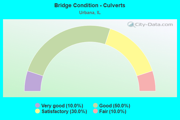
- Bridge Condition - Culverts
- 10.0%Very good
- 50.0%Good
- 30.0%Satisfactory
- 10.0%Fair
Find on map >> Show street view
Structure Number: 10611, Location: E OF COLER AVE (Lat: 40.112586, Lng: -88.215406), Route carried "on" structure: Other road , Year Built: 1900, Status: Open, Structure Length: 0.79m (2.59ft), Average Daily Traffic: 5,500 (year 2021), Truck Traffic: 6%, Average Future Daily Traffic: 9,701 (year 2032), Features Intersected: BONEYARD CREEK, Facility Carried by Structure: SPRINGFIELD(FAU 71
Minimum Vertical Clearance: 30+ m (98+ ft), Kilometerpoint: 1.159, Lanes on structure: 2, Base Highway Network: Yes, Owner: City or Municipal Highway Agency, Approaching Roadway Width: 11.0m (36.1ft), Skew: 4 degrees, Material/Design: Concrete, Design/Construction: Culvert, Number Of Spans In Main Unit: 1, Length of Maximum Span: 6.4m (21.0ft), Curb or Sidewalk Widths: Left: 1.2m (3.9ft), Right: 1.2m (3.9ft), Curb-To-Curb Width: 11.0m (36.1ft), Out-to-Out Width: 18.3m (60.0ft)
Condition: Channel: Very good, Culverts: Satisfactory, Operating Rating: 40.5 metric tons, Method Used To Determine Operating Rating: Field evaluation and documented engineering judgment, Inventory Rating: 24.3 metric tons, Method Used To Determine Inventory Rating: Field evaluation and documented engineering judgment, Structural Evaluation: Equal to present minimum criteria, Deck Geometry: Meets minimum limits, Waterway Adequacy: Equal to present minimum criteria, Approach Roadway Alignment: Equal to present desirable criteria, Designated Inspection Frequency: Every 24 months, Inspection Date: November 2020, Wearing Surface/Protective System: Wearing Surface: Bituminous
Find on map >> Show street view
Structure Number: 106114, Location: URBANA (Lat: 40.114375, Lng: -88.209744), Route carried "on" structure: City street , Year Built: 1900, Year Reconstructed: 1954, Status: Open, Structure Length: 0.67m (2.20ft), Average Daily Traffic: 300 (year 2021), Truck Traffic: 3%, Average Future Daily Traffic: 574 (year 2032), Design Load: H 20, Features Intersected: BONEYARD CREEK, Facility Carried by Structure: GRIGGS ST
Minimum Vertical Clearance: 30+ m (98+ ft), Kilometerpoint: 0.418, Lanes on structure: 2, Owner: City or Municipal Highway Agency, Approaching Roadway Width: 9.4m (30.8ft), Material/Design: Concrete continuous, Design/Construction: Culvert, Number Of Spans In Main Unit: 1, Length of Maximum Span: 6.7m (22.0ft), Curb or Sidewalk Widths: Left: 1.8m (5.9ft), Right: 1.8m (5.9ft), Curb-To-Curb Width: 10.5m (34.4ft), Out-to-Out Width: 14.2m (46.6ft)
Condition: Channel: Very good, Culverts: Satisfactory, Operating Rating: 49.2 metric tons, Method Used To Determine Operating Rating: Load Factor (LF) rating reported by rating factor (RF) method using MS18 loading, Inventory Rating: 29.5 metric tons, Method Used To Determine Inventory Rating: Load Factor (LF) rating reported by rating factor (RF) method using MS18 loading, Structural Evaluation: Equal to present minimum criteria, Deck Geometry: Better than present minimum criteria, Waterway Adequacy: Equal to present desirable criteria, Approach Roadway Alignment: Equal to present desirable criteria, Designated Inspection Frequency: Every 24 months, Inspection Date: November 2020, Deck Structure Type: Concrete Cast-file-Place, Wearing Surface/Protective System: Wearing Surface: Bituminous
Find on map >> Show street view
Structure Number: 106118, Location: S OF UNIVERSITY AVE (Lat: 40.115525, Lng: -88.207522), Route carried "on" structure: City street , Year Built: 1900, Year Reconstructed: 1953, Status: Open, Structure Length: 0.70m (2.30ft), Average Daily Traffic: 3,000 (year 2021), Truck Traffic: 10%, Average Future Daily Traffic: 3,046 (year 2032), Design Load: H 20, Features Intersected: BONEYARD CREEK, Facility Carried by Structure: BROADWAY(MS 6540)
Minimum Vertical Clearance: 30+ m (98+ ft), Kilometerpoint: 1.304, Lanes on structure: 4, Owner: City or Municipal Highway Agency, Approaching Roadway Width: 17.7m (58.1ft), Material/Design: Concrete, Design/Construction: Culvert, Number Of Spans In Main Unit: 1, Length of Maximum Span: 6.4m (21.0ft), Curb or Sidewalk Widths: Left: 2.1m (6.9ft), Right: 2.1m (6.9ft), Curb-To-Curb Width: 19.5m (64.0ft), Out-to-Out Width: 25.1m (82.3ft)
Condition: Channel: Good, Culverts: Fair, Operating Rating: 40.5 metric tons, Method Used To Determine Operating Rating: Field evaluation and documented engineering judgment, Inventory Rating: 24.3 metric tons, Method Used To Determine Inventory Rating: Field evaluation and documented engineering judgment, Structural Evaluation: Somewhat better than minimum adequacy, Deck Geometry: Better than present minimum criteria, Waterway Adequacy: Better than present minimum criteria, Approach Roadway Alignment: Equal to present desirable criteria, Length Of Structure Improvement: 1.68m (5.51ft), Designated Inspection Frequency: Every 24 months, Inspection Date: November 2020, Bridge Improvement Cost: $71,000, Roadway Improvement Cost: $7,000, Total Project Cost: $106,000, Wearing Surface/Protective System: Wearing Surface: Bituminous
Find on map >> Show street view
Structure Number: 106128, Location: N OF UNIVERSITY AVE (Lat: 40.119403, Lng: -88.207594), Route carried "on" structure: City street , Year Built: 1982, Status: Open, Structure Length: 2.56m (8.40ft), Average Daily Traffic: 4,250 (year 2021), Truck Traffic: 4%, Average Future Daily Traffic: 4,117 (year 2032), Design Load: HS 20, Features Intersected: SALINE BRANCH, Facility Carried by Structure: FAU 7182(BROADWAY)
Minimum Vertical Clearance: 30+ m (98+ ft), Kilometerpoint: 0.885, Lanes on structure: 2, Owner: City or Municipal Highway Agency, Approaching Roadway Width: 9.4m (30.8ft), Material/Design: Prestressed concrete, Design/Construction: Box Beam or Girders - Multiple, Number Of Spans In Main Unit: 3, Length of Maximum Span: 12.2m (40.0ft), Curb or Sidewalk Widths: Left: 1.5m (4.9ft), Right: 1.5m (4.9ft), Curb-To-Curb Width: 9.1m (29.9ft), Out-to-Out Width: 13.0m (42.7ft)
Condition: Deck: Fair, Superstructure: Fair, Substructure: Poor, Channel: Good, Operating Rating: 76.1 metric tons, Method Used To Determine Operating Rating: Load Factor (LF) rating reported by rating factor (RF) method using MS18 loading, Inventory Rating: 45.4 metric tons, Method Used To Determine Inventory Rating: Load Factor (LF) rating reported by rating factor (RF) method using MS18 loading, Structural Evaluation: Meets minimum limits, Deck Geometry: Meets minimum limits, Waterway Adequacy: Equal to present desirable criteria, Approach Roadway Alignment: Equal to present desirable criteria, Designated Inspection Frequency: Every 24 months, Inspection Date: November 2020, Deck Structure Type: Concrete Precast Panels, Wearing Surface/Protective System: Wearing Surface: Bituminous, Deck Protection: Bituminous
Find on map >> Show street view
Structure Number: 106129, Location: N URBANA W OF LINCOL (Lat: 40.145050, Lng: -88.223122), Route carried "on" structure: City street , Year Built: 1990, Status: Open, Structure Length: 3.11m (10.20ft), Average Daily Traffic: 650 (year 2021), Truck Traffic: 68%, Average Future Daily Traffic: 67 (year 2032), Design Load: HS 20, Features Intersected: SALINE BRANCH, Facility Carried by Structure: SOMER DR (MS 1400)
Minimum Vertical Clearance: 30+ m (98+ ft), Kilometerpoint: 0.016, Lanes on structure: 2, Owner: City or Municipal Highway Agency, Approaching Roadway Width: 10.1m (33.1ft), Material/Design: Prestressed concrete, Design/Construction: Box Beam or Girders - Multiple, Number Of Spans In Main Unit: 3, Length of Maximum Span: 10.2m (33.5ft), Curb or Sidewalk Widths: Left: 1.4m (4.6ft), Right: 1.4m (4.6ft), Curb-To-Curb Width: 10.1m (33.1ft), Out-to-Out Width: 12.8m (42.0ft)
Condition: Deck: Satisfactory, Superstructure: Satisfactory, Substructure: Fair, Channel: Satisfactory, Operating Rating: 44.1 metric tons, Method Used To Determine Operating Rating: Assigned rating based on Load Factor Design (LFD) reported by rating factor (RF) using MS18 loading, Inventory Rating: 32.4 metric tons, Method Used To Determine Inventory Rating: Assigned rating based on Load Factor Design (LFD) reported by rating factor (RF) using MS18 loading, Structural Evaluation: Somewhat better than minimum adequacy, Deck Geometry: Equal to present minimum criteria, Waterway Adequacy: Equal to present desirable criteria, Approach Roadway Alignment: Equal to present desirable criteria, Designated Inspection Frequency: Every 24 months, Inspection Date: November 2020, Deck Structure Type: Concrete Precast Panels, Wearing Surface/Protective System: Wearing Surface: Bituminous
Find on map >> Show street view
Structure Number: 10613, Location: LINCOLN AVE & OAK RD (Lat: 40.148336, Lng: -88.219989), Route carried "on" structure: Other road , Year Built: 2004, Status: Open, Structure Length: 3.43m (11.25ft), Average Daily Traffic: 2,300 (year 2021), Truck Traffic: 27%, Average Future Daily Traffic: 1,297 (year 2032), Design Load: HS 20, Features Intersected: SALINE BRANCH, Facility Carried by Structure: FAU 7177/LINCOLN
Minimum Vertical Clearance: 30+ m (98+ ft), Kilometerpoint: 1.706, Lanes on structure: 2, Base Highway Network: Yes, Owner: City or Municipal Highway Agency, Approaching Roadway Width: 7.3m (24.0ft), Skew: 3 degrees, Material/Design: Prestressed concrete, Design/Construction: Stringer/Multi-beam, Number Of Spans In Main Unit: 1, Length of Maximum Span: 33.2m (108.9ft), Curb-To-Curb Width: 8.2m (26.9ft), Out-to-Out Width: 9.5m (31.2ft)
Condition: Deck: Very good, Superstructure: Very good, Substructure: Very good, Channel: Very good, Operating Rating: 44.1 metric tons, Method Used To Determine Operating Rating: Assigned rating based on Load Factor Design (LFD) reported by rating factor (RF) using MS18 loading, Inventory Rating: 32.4 metric tons, Method Used To Determine Inventory Rating: Assigned rating based on Load Factor Design (LFD) reported by rating factor (RF) using MS18 loading, Structural Evaluation: Equal to present desirable criteria, Deck Geometry: High priority of corrective action, Waterway Adequacy: Equal to present desirable criteria, Approach Roadway Alignment: Equal to present desirable criteria, Designated Inspection Frequency: Every 24 months, Inspection Date: November 2020, Deck Structure Type: Concrete Cast-file-Place
Find on map >> Show street view
Structure Number: 106136, Location: 600 ft S o US 45 (Lat: 40.114667, Lng: -88.209033), Route carried "on" structure: Other road , Year Built: 2014, Status: Open, Structure Length: 1.21m (3.97ft), Average Daily Traffic: 2,500 (year 2021), Truck Traffic: 2%, Average Future Daily Traffic: 5,500 (year 2031), Design Load: HS 25 or greater, Features Intersected: Boneyard Creek, Facility Carried by Structure: Race St. (FAU 7181
Minimum Vertical Clearance: 30+ m (98+ ft), Kilometerpoint: 0.209, Lanes on structure: 2, Owner: City or Municipal Highway Agency, Approaching Roadway Width: 7.6m (24.9ft), Material/Design: Prestressed concrete, Design/Construction: Box Beam or Girders - Multiple, Number Of Spans In Main Unit: 1, Length of Maximum Span: 11.7m (38.4ft), Curb or Sidewalk Widths: Left: 2.8m (9.2ft), Right: 3.2m (10.5ft), Curb-To-Curb Width: 7.6m (24.9ft), Out-to-Out Width: 14.3m (46.9ft)
Condition: Deck: Very good, Superstructure: Very good, Substructure: Very good, Channel: Excellent, Operating Rating: 42.1 metric tons, Method Used To Determine Operating Rating: Assigned ratings based on Load and Resistance Factor Design (LRFD) reported by rating factor (RF) using HL93 loadings, Inventory Rating: 32.4 metric tons, Method Used To Determine Inventory Rating: Assigned ratings based on Load and Resistance Factor Design (LRFD) reported by rating factor (RF) using HL93 loadings, Structural Evaluation: Equal to present desirable criteria, Deck Geometry: High priority of replacement, Waterway Adequacy: Superior to present desirable criteria, Approach Roadway Alignment: Equal to present desirable criteria, Designated Inspection Frequency: Every 48 months, Inspection Date: November 2020, Deck Structure Type: Concrete Precast Panels
Find on map >> Show street view
Structure Number: 100021, Location: CHAMPAIGN (Lat: 40.134853, Lng: -88.231181), Route carried "under" structure: County highway , Year Built: 1956, Structure Length: 0. m, Average Daily Traffic: 450 (year 2021), Truck Traffic: 10%, Features Intersected: IC RR & TR 158, Facility Carried by Structure: I-74
Minimum Vertical Clearance: 5.38m (17.65ft), Kilometerpoint: 0.515, Lanes on structure: 6, Lanes under structure: 2, Material/Design: Steel continuous, Design/Construction: Stringer/Multi-beam, Length of Maximum Span: 68.7m (225.4ft)
Find on map >> Show street view
Structure Number: 100024, Location: N OF URBANA (Lat: 40.133794, Lng: -88.195719), Route carried "under" structure: US 45, Year Built: 1956, Structure Length: 0. m, Average Daily Traffic: 17,300 (year 2021), Truck Traffic: 5%, Features Intersected: US 45(FAP 800), Facility Carried by Structure: I-74
Minimum Vertical Clearance: 4.57m (14.99ft), Kilometerpoint: 401.311, Lanes on structure: 4, Lanes under structure: 6, Material/Design: Steel continuous, Design/Construction: Stringer/Multi-beam, Length of Maximum Span: 15.2m (49.9ft)
Find on map >> Show street view
Structure Number: 100033, Location: E OF URBANA (Lat: 40.121267, Lng: -88.173639), Route carried "under" structure: Interstate 74, Year Built: 1960, Structure Length: 0. m, Average Daily Traffic: 28,700 (year 2021), Truck Traffic: 28%, Features Intersected: I-74 & RMP 17.17
Minimum Vertical Clearance: 5.49m (18.01ft), Kilometerpoint: 301.277, Lanes on structure: 3, Lanes under structure: 4, Material/Design: Prestressed concrete, Design/Construction: Stringer/Multi-beam, Length of Maximum Span: 22.6m (74.1ft)
Find on map >> Show street view
Structure Number: 10011, Location: S OF UNIVERSITY AVE (Lat: 40.114775, Lng: -88.205081), Route carried "under" structure: Other road , Year Built: 1933, Structure Length: 0. m, Average Daily Traffic: 17,300 (year 2021), Truck Traffic: 3%, Features Intersected: VINE ST(FAU 7183), Facility Carried by Structure: IC RR
Minimum Vertical Clearance: 4.32m (14.17ft), Kilometerpoint: 0.177, Lanes under structure: 4, Material/Design: Steel, Design/Construction: Stringer/Multi-beam, Length of Maximum Span: 14.6m (47.9ft)
Find on map >> Show street view
Structure Number: 100158, Location: CHAMPAIGN (Lat: 40.134981, Lng: -88.219569), Route carried "under" structure: Interstate 74, Year Built: 1956, Structure Length: 0. m, Average Daily Traffic: 50,000 (year 2019), Truck Traffic: 17%, Features Intersected: I-74, Facility Carried by Structure: FAU7177(LINC)
Minimum Vertical Clearance: 5.13m (16.83ft), Kilometerpoint: 296.835, Lanes on structure: 6, Lanes under structure: 4, Material/Design: Steel continuous, Design/Construction: Stringer/Multi-beam, Length of Maximum Span: 15.7m (51.5ft)
Find on map >> Show street view
Structure Number: 100173, Location: NE OF URBANA (Lat: 40.129211, Lng: -88.184989), Route carried "under" structure: Interstate 74, Year Built: 1960, Structure Length: 0. m, Average Daily Traffic: 33,600 (year 2021), Truck Traffic: 26%, Features Intersected: I-74, Facility Carried by Structure: TR 173(FAU 7110)
Minimum Vertical Clearance: 5.16m (16.93ft), Kilometerpoint: 299.941, Lanes on structure: 2, Lanes under structure: 4, Material/Design: Prestressed concrete, Design/Construction: Stringer/Multi-beam, Length of Maximum Span: 17.3m (56.8ft)
Find on map >> Show street view
Structure Number: 100175, Location: E OF URBANA (Lat: 40.120247, Lng: -88.162700), Route carried "under" structure: Interstate 74, Year Built: 1960, Structure Length: 0. m, Average Daily Traffic: 28,700 (year 2021), Truck Traffic: 28%, Features Intersected: I-74, Facility Carried by Structure: HIGHCROSS RD
Minimum Vertical Clearance: 4.90m (16.08ft), Kilometerpoint: 302.210, Lanes on structure: 2, Lanes under structure: 4, Material/Design: Prestressed concrete, Design/Construction: Stringer/Multi-beam, Length of Maximum Span: 17.1m (56.1ft)
Find on map >> Show street view
Structure Number: 100177, Location: 2 MI W OF MAYVIEW (Lat: 40.120361, Lng: -88.143669), Route carried "under" structure: Interstate 74, Year Built: 1960, Structure Length: 0. m, Average Daily Traffic: 28,700 (year 2021), Truck Traffic: 28%, Features Intersected: I-74, Facility Carried by Structure: FAU 7206
Minimum Vertical Clearance: 4.83m (15.85ft), Kilometerpoint: 303.836, Lanes on structure: 2, Lanes under structure: 4, Material/Design: Prestressed concrete, Design/Construction: Stringer/Multi-beam, Length of Maximum Span: 17.1m (56.1ft)
Find on map >> Show street view
Structure Number: 100288, Location: 1 MI NW OF MAYVIEW (Lat: 40.120469, Lng: -88.124700), Route carried "under" structure: Interstate 74, Year Built: 2010, Structure Length: 0. m, Average Daily Traffic: 28,700 (year 2021), Truck Traffic: 28%, Features Intersected: I-74, Facility Carried by Structure: TR 230
Minimum Vertical Clearance: 5.33m (17.49ft), Kilometerpoint: 305.445, Lanes on structure: 2, Lanes under structure: 4, Material/Design: Steel continuous, Design/Construction: Stringer/Multi-beam, Length of Maximum Span: 33.8m (110.9ft)