Bridge Statistics for Vandalia, Illinois (IL)
Condition, Traffic, Stress, Structural Evaluation, Project Costs
- National Bridge Inventory (NBI) Statistics
- 89Number of bridges
- 1,155ft / 352mTotal length
- $20,709,000Total costs
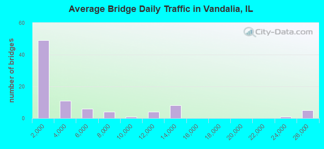
- 415,330Total average daily traffic
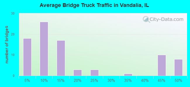
- 143,081Total average daily truck traffic
- National Bridge Inventory (NBI) Registered Bridges for Vandalia
- No street view available for this location
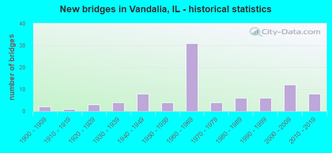
- New bridges - historical statistics
- 21900-1909
- 11910-1919
- 31920-1929
- 41930-1939
- 81940-1949
- 41950-1959
- 311960-1969
- 41970-1979
- 61980-1989
- 61990-1999
- 122000-2009
- 82010-2019
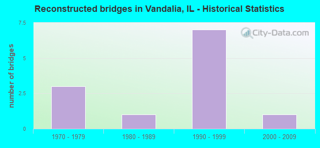
- Reconstructed bridges - Historical Statistics
- 31970-1979
- 11980-1989
- 71990-1999
- 12000-2009
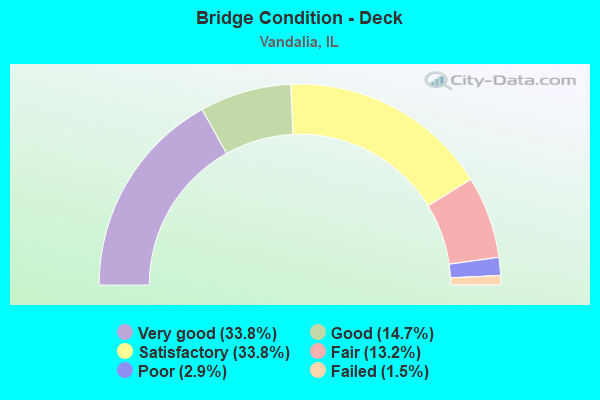
- Bridge Condition - Deck
- 33.8%Very good
- 14.7%Good
- 33.8%Satisfactory
- 13.2%Fair
- 2.9%Poor
- 1.5%Failed

- Bridge Condition - Superstructure
- 41.2%Very good
- 17.6%Good
- 19.1%Satisfactory
- 16.2%Fair
- 4.4%Poor
- 1.5%Failed
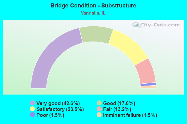
- Bridge Condition - Substructure
- 42.6%Very good
- 17.6%Good
- 23.5%Satisfactory
- 13.2%Fair
- 1.5%Poor
- 1.5%Imminent failure
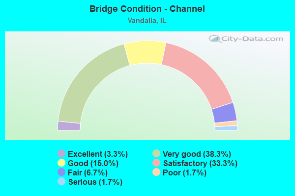
- Bridge Condition - Channel
- 3.3%Excellent
- 38.3%Very good
- 15.0%Good
- 33.3%Satisfactory
- 6.7%Fair
- 1.7%Poor
- 1.7%Serious
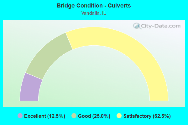
- Bridge Condition - Culverts
- 12.5%Excellent
- 25.0%Good
- 62.5%Satisfactory
Find on map >> Show street view
Structure Number: 260032, Location: US-51 VANDALIA INT (Lat: 38.978489, Lng: -89.096231), Route carried "under" structure: Interstate 70, Year Built: 1964, Structure Length: 0. m, Average Daily Traffic: 25,000 (year 2021), Truck Traffic: 47%, Features Intersected: FAI-70, Facility Carried by Structure: FAP-322 (US-51)
Minimum Vertical Clearance: 5.26m (17.26ft), Kilometerpoint: 107.855, Lanes on structure: 4, Lanes under structure: 4, Material/Design: Steel continuous, Design/Construction: Stringer/Multi-beam, Length of Maximum Span: 25.6m (84.0ft)
Find on map >> Show street view
Structure Number: 260073, Location: 2.2MI W. US-40 INT. (Lat: 38.956231, Lng: -89.170708), Route carried "under" structure: Interstate 70, Year Built: 1966, Structure Length: 0. m, Average Daily Traffic: 25,100 (year 2021), Truck Traffic: 40%, Features Intersected: FAI-70 & US-40, Facility Carried by Structure: CH-11(HAGARSTOWN R
Minimum Vertical Clearance: 4.90m (16.08ft), Kilometerpoint: 100.742, Lanes on structure: 2, Lanes under structure: 6, Material/Design: Steel continuous, Design/Construction: Stringer/Multi-beam, Length of Maximum Span: 23.5m (77.1ft)
Find on map >> Show street view
Structure Number: 260073, Location: 2.2MI W. US-40 INT. (Lat: 38.956869, Lng: -89.170719), Route carried "under" structure: US 40, Year Built: 1966, Structure Length: 0. m, Average Daily Traffic: 1,500 (year 2021), Truck Traffic: 11%, Features Intersected: FAI-70 & US-40, Facility Carried by Structure: CH-11(HAGARSTOWN R
Minimum Vertical Clearance: 5.51m (18.08ft), Kilometerpoint: 100.195, Lanes on structure: 2, Lanes under structure: 6, Material/Design: Steel continuous, Design/Construction: Stringer/Multi-beam, Length of Maximum Span: 23.5m (77.1ft)
Find on map >> Show street view
Structure Number: 260074, Location: 3.5 MI E BOND CO LN (Lat: 38.948769, Lng: -89.193769), Route carried "under" structure: US 40, Year Built: 1965, Structure Length: 0. m, Average Daily Traffic: 1,500 (year 2021), Truck Traffic: 11%, Features Intersected: FAI-70 & US 40, Facility Carried by Structure: TR-78
Minimum Vertical Clearance: 5.56m (18.24ft), Kilometerpoint: 98.006, Lanes on structure: 2, Lanes under structure: 6, Material/Design: Steel continuous, Design/Construction: Stringer/Multi-beam, Length of Maximum Span: 23.5m (77.1ft)
Find on map >> Show street view
Structure Number: 260074, Location: 3.5 MI E BOND CO LN (Lat: 38.948131, Lng: -89.193761), Route carried "under" structure: Interstate 70, Year Built: 1965, Structure Length: 0. m, Average Daily Traffic: 25,100 (year 2021), Truck Traffic: 40%, Features Intersected: FAI-70 & US 40, Facility Carried by Structure: TR-78
Minimum Vertical Clearance: 4.98m (16.34ft), Kilometerpoint: 98.554, Lanes on structure: 2, Lanes under structure: 6, Material/Design: Steel continuous, Design/Construction: Stringer/Multi-beam, Length of Maximum Span: 23.5m (77.1ft)
Find on map >> Show street view
Structure Number: 260075, Location: 2 MI W BROWNSTWN INT (Lat: 38.975269, Lng: -89.038000), Route carried "under" structure: Interstate 70, Year Built: 1964, Structure Length: 0. m, Average Daily Traffic: 25,000 (year 2021), Truck Traffic: 47%, Features Intersected: FAI-70, Facility Carried by Structure: TR-264
Minimum Vertical Clearance: 4.90m (16.08ft), Kilometerpoint: 112.941, Lanes on structure: 2, Lanes under structure: 4, Material/Design: Steel continuous, Design/Construction: Stringer/Multi-beam, Length of Maximum Span: 20.4m (66.9ft)
Find on map >> Show street view
Structure Number: 260077, Location: 1 MI W. US-40 INT (Lat: 38.962569, Lng: -89.152642), Route carried "under" structure: Interstate 70, Year Built: 1966, Structure Length: 0. m, Average Daily Traffic: 25,100 (year 2021), Truck Traffic: 40%, Features Intersected: FAI-70 & US-40, Facility Carried by Structure: TR-373
Minimum Vertical Clearance: 4.90m (16.08ft), Kilometerpoint: 102.448, Lanes on structure: 2, Lanes under structure: 6, Material/Design: Steel continuous, Design/Construction: Stringer/Multi-beam, Length of Maximum Span: 25.0m (82.0ft)
Find on map >> Show street view
Structure Number: 260077, Location: 1 MI W. US-40 INT (Lat: 38.963000, Lng: -89.153281), Route carried "under" structure: US 40, Year Built: 1966, Structure Length: 0. m, Average Daily Traffic: 1,300 (year 2021), Truck Traffic: 16%, Features Intersected: FAI-70 & US-40, Facility Carried by Structure: TR-373
Minimum Vertical Clearance: 4.45m (14.60ft), Kilometerpoint: 101.853, Lanes on structure: 2, Lanes under structure: 2, Material/Design: Steel continuous, Design/Construction: Stringer/Multi-beam, Length of Maximum Span: 25.0m (82.0ft)
Find on map >> Show street view
Structure Number: 260087, Location: W. VANDALIA INT. (Lat: 38.969428, Lng: -89.133081), Route carried "under" structure: Interstate 70, Year Built: 1977, Structure Length: 0. m, Average Daily Traffic: 23,600 (year 2021), Truck Traffic: 43%, Features Intersected: FAI-70, Facility Carried by Structure: FAU-8413 (US-40)
Minimum Vertical Clearance: 4.90m (16.08ft), Kilometerpoint: 104.315, Lanes on structure: 2, Lanes under structure: 4, Material/Design: Steel continuous, Design/Construction: Stringer/Multi-beam, Length of Maximum Span: 31.1m (102.0ft)