Bridge Statistics for Visalia, California (CA)
Condition, Traffic, Stress, Structural Evaluation, Project Costs
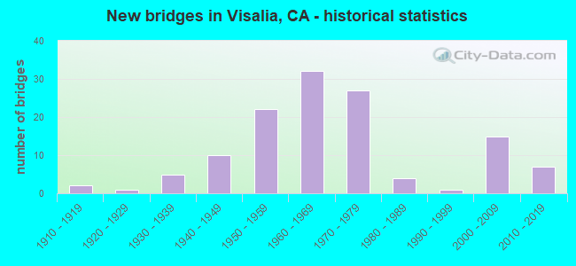
- New bridges - historical statistics
- 21910-1919
- 11920-1929
- 51930-1939
- 101940-1949
- 221950-1959
- 321960-1969
- 271970-1979
- 41980-1989
- 11990-1999
- 152000-2009
- 72010-2019
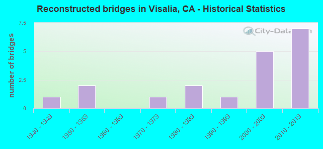
- Reconstructed bridges - Historical Statistics
- 11940-1949
- 21950-1959
- 01960-1969
- 11970-1979
- 21980-1989
- 11990-1999
- 52000-2009
- 72010-2019
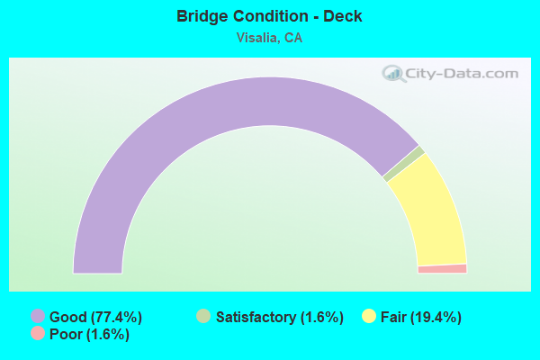
- Bridge Condition - Deck
- 77.4%Good
- 1.6%Satisfactory
- 19.4%Fair
- 1.6%Poor
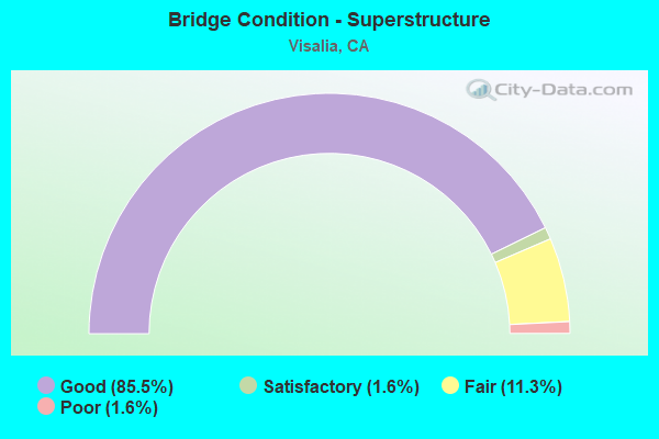
- Bridge Condition - Superstructure
- 85.5%Good
- 1.6%Satisfactory
- 11.3%Fair
- 1.6%Poor
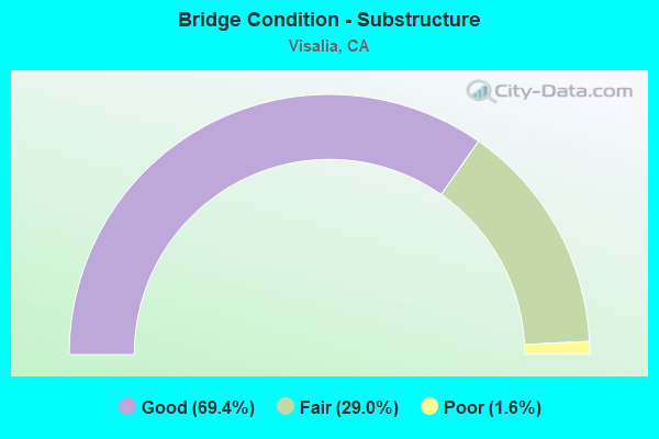
- Bridge Condition - Substructure
- 69.4%Good
- 29.0%Fair
- 1.6%Poor
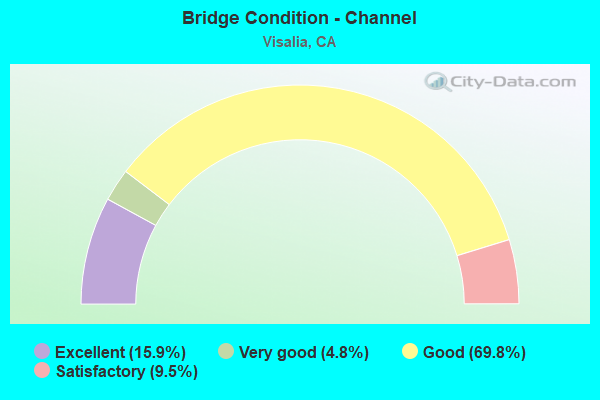
- Bridge Condition - Channel
- 15.9%Excellent
- 4.8%Very good
- 69.8%Good
- 9.5%Satisfactory
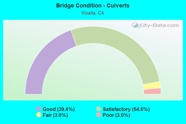
- Bridge Condition - Culverts
- 39.4%Good
- 54.5%Satisfactory
- 3.0%Fair
- 3.0%Poor
Find on map >> Show street view
Structure Number: 46C0433, Location: 0.5 MI NORTH OF AVE 264 (Lat: 36.276342, Lng: -119.349222), Route carried "on" structure: County highway , Year Built: 1952, Status: Open, Structure Length: 0.83m (2.72ft), Average Daily Traffic: 550 (year 1983), Truck Traffic: 5%, Average Future Daily Traffic: 657 (year 2042), Features Intersected: TULARE CANAL, Facility Carried by Structure: ROAD 100
Minimum Vertical Clearance: 30+ m (98+ ft), Kilometerpoint: 0.000, Lanes on structure: 2, Owner: County Highway Agency, Approaching Roadway Width: 7.9m (25.9ft), Material/Design: Concrete continuous, Design/Construction: Culvert, Number Of Spans In Main Unit: 3, Length of Maximum Span: 2.7m (8.9ft), Curb-To-Curb Width: 11.0m (36.1ft), Out-to-Out Width: 11.5m (37.7ft)
Condition: Channel: Good, Culverts: Poor, Operating Rating: 40.5 metric tons, Method Used To Determine Operating Rating: Field evaluation and documented engineering judgment, Inventory Rating: 24.3 metric tons, Method Used To Determine Inventory Rating: Field evaluation and documented engineering judgment, Structural Evaluation: Meets minimum limits, Deck Geometry: Better than present minimum criteria, Waterway Adequacy: Equal to present desirable criteria, Approach Roadway Alignment: Equal to present desirable criteria, Length Of Structure Improvement: 0.83m (2.72ft), Designated Inspection Frequency: Every 24 months, Inspection Date: March 2022, Bridge Improvement Cost: $96,000, Roadway Improvement Cost: $19,000, Total Project Cost: $161,000 ( Estimate for 2021), Deck Structure Type: Concrete Cast-file-Place, Wearing Surface/Protective System: Wearing Surface: Bituminous
Find on map >> Show street view
Structure Number: 46C0434, Location: 0.2 MI SOUTH OF AVE 272 (Lat: 36.280456, Lng: -119.349256), Route carried "on" structure: County highway , Year Built: 1951, Status: Open, Structure Length: 1.45m (4.76ft), Average Daily Traffic: 550 (year 1983), Truck Traffic: 5%, Average Future Daily Traffic: 657 (year 2042), Features Intersected: PACKWOOD CREEK, Facility Carried by Structure: ROAD 100
Minimum Vertical Clearance: 30+ m (98+ ft), Kilometerpoint: 0.000, Lanes on structure: 2, Owner: County Highway Agency, Approaching Roadway Width: 7.9m (25.9ft), Material/Design: Concrete continuous, Design/Construction: Slab, Number Of Spans In Main Unit: 3, Length of Maximum Span: 5.5m (18.0ft), Curb or Sidewalk Widths: Left: 0.3m (1.0ft), Right: 0.3m (1.0ft), Curb-To-Curb Width: 7.9m (25.9ft), Out-to-Out Width: 8.5m (27.9ft)
Condition: Deck: Good, Superstructure: Good, Substructure: Fair, Channel: Good, Operating Rating: 42.4 metric tons, Method Used To Determine Operating Rating: Load Factor (LF), Inventory Rating: 25.6 metric tons, Method Used To Determine Inventory Rating: Load Factor (LF), Structural Evaluation: Somewhat better than minimum adequacy, Deck Geometry: Somewhat better than minimum adequacy, Waterway Adequacy: Equal to present desirable criteria, Approach Roadway Alignment: Equal to present desirable criteria, Designated Inspection Frequency: Every 24 months, Inspection Date: March 2022, Deck Structure Type: Concrete Cast-file-Place, Wearing Surface/Protective System: Wearing Surface: Bituminous
Find on map >> Show street view
Structure Number: 46C0435, Location: 0.1 MI NE SR 198 (Lat: 36.328175, Lng: -119.324925), Route carried "on" structure: City street , Year Built: 1940, Status: Open, Structure Length: 0.76m (2.49ft), Average Daily Traffic: 7,500 (year 1984), Truck Traffic: 5%, Average Future Daily Traffic: 8,608 (year 2042), Features Intersected: MILL CREEK, Facility Carried by Structure: MAIN STREET
Minimum Vertical Clearance: 30+ m (98+ ft), Kilometerpoint: 0.000, Lanes on structure: 2, Owner: City or Municipal Highway Agency, Approaching Roadway Width: 14.0m (45.9ft), Skew: 3 degrees, Material/Design: Concrete continuous, Design/Construction: Slab, Number Of Spans In Main Unit: 2, Length of Maximum Span: 3.4m (11.2ft), Curb or Sidewalk Widths: Left: 1.8m (5.9ft), Right: 1.4m (4.6ft), Curb-To-Curb Width: 11.4m (37.4ft), Out-to-Out Width: 15.3m (50.2ft)
Condition: Deck: Good, Superstructure: Good, Substructure: Fair, Channel: Good, Operating Rating: 26.9 metric tons, Method Used To Determine Operating Rating: Field evaluation and documented engineering judgment, Inventory Rating: 16.2 metric tons, Method Used To Determine Inventory Rating: Field evaluation and documented engineering judgment, Structural Evaluation: Meets minimum limits, Deck Geometry: Meets minimum limits, Waterway Adequacy: Equal to present desirable criteria, Approach Roadway Alignment: Equal to present desirable criteria, Designated Inspection Frequency: Every 24 months, Inspection Date: March 2020, Deck Structure Type: Concrete Cast-file-Place, Wearing Surface/Protective System: Wearing Surface: Bituminous
Find on map >> Show street view
Structure Number: 46C0436, Location: 0.5 MI SOUTH OF AVE 272 (Lat: 36.276575, Lng: -119.331306), Route carried "on" structure: County highway , Year Built: 1950, Year Reconstructed: 2012, Status: Open, Structure Length: 0.83m (2.72ft), Average Daily Traffic: 8,600 (year 1984), Truck Traffic: 5%, Average Future Daily Traffic: 10,011 (year 2042), Features Intersected: TULARE IRRIG DIST CANAL, Facility Carried by Structure: ROAD 108 (DEMAREE)
Minimum Vertical Clearance: 30+ m (98+ ft), Kilometerpoint: 0.000, Lanes on structure: 5, Owner: County Highway Agency, Approaching Roadway Width: 27.0m (88.6ft), Material/Design: Concrete continuous, Design/Construction: Culvert, Number Of Spans In Main Unit: 3, Length of Maximum Span: 2.7m (8.9ft), Curb-To-Curb Width: 36.1m (118.4ft), Out-to-Out Width: 36.8m (120.7ft)
Condition: Channel: Good, Culverts: Fair, Operating Rating: 40.5 metric tons, Method Used To Determine Operating Rating: Field evaluation and documented engineering judgment, Inventory Rating: 24.3 metric tons, Method Used To Determine Inventory Rating: Field evaluation and documented engineering judgment, Structural Evaluation: Somewhat better than minimum adequacy, Deck Geometry: Superior to present desirable criteria, Waterway Adequacy: Equal to present desirable criteria, Approach Roadway Alignment: Equal to present desirable criteria, Designated Inspection Frequency: Every 24 months, Inspection Date: March 2022, Deck Structure Type: Concrete Cast-file-Place, Wearing Surface/Protective System: Wearing Surface: Bituminous
Find on map >> Show street view
Structure Number: 46C0437, Location: 0.25 MI NORTH OF AVE 272 (Lat: 36.287556, Lng: -119.331192), Route carried "on" structure: County highway , Year Built: 1975, Year Reconstructed: 2012, Status: Open, Structure Length: 0.79m (2.59ft), Average Daily Traffic: 7,900 (year 1983), Truck Traffic: 5%, Average Future Daily Traffic: 9,455 (year 2042), Design Load: HS 20, Features Intersected: PACKWOOD CREEK, Facility Carried by Structure: ROAD 108
Minimum Vertical Clearance: 30+ m (98+ ft), Kilometerpoint: 0.000, Lanes on structure: 4, Owner: County Highway Agency, Approaching Roadway Width: 27.6m (90.6ft), Skew: 1 degrees, Material/Design: Concrete continuous, Design/Construction: Culvert, Number Of Spans In Main Unit: 2, Length of Maximum Span: 3.7m (12.1ft), Curb-To-Curb Width: 27.6m (90.6ft), Out-to-Out Width: 34.2m (112.2ft)
Condition: Channel: Very good, Culverts: Satisfactory, Operating Rating: 54.1 metric tons, Method Used To Determine Operating Rating: Field evaluation and documented engineering judgment, Inventory Rating: 32.4 metric tons, Method Used To Determine Inventory Rating: Field evaluation and documented engineering judgment, Structural Evaluation: Equal to present minimum criteria, Deck Geometry: Superior to present desirable criteria, Waterway Adequacy: Equal to present desirable criteria, Approach Roadway Alignment: Equal to present desirable criteria, Designated Inspection Frequency: Every 48 months, Inspection Date: March 2020, Deck Structure Type: Concrete Cast-file-Place, Wearing Surface/Protective System: Wearing Surface: Bituminous
Find on map >> Show street view
Structure Number: 46C0439, Location: 0.15 MI N OF SR 198 (Lat: 36.330047, Lng: -119.341178), Route carried "on" structure: County highway , Year Built: 1953, Status: Open, Structure Length: 0.79m (2.59ft), Average Daily Traffic: 500 (year 1988), Truck Traffic: 2%, Average Future Daily Traffic: 657 (year 2042), Design Load: H 15, Features Intersected: MILL CREEK, Facility Carried by Structure: LINWOOD AVE
Minimum Vertical Clearance: 30+ m (98+ ft), Kilometerpoint: 0.000, Lanes on structure: 2, Owner: City or Municipal Highway Agency, Approaching Roadway Width: 12.2m (40.0ft), Material/Design: Concrete continuous, Design/Construction: Culvert, Number Of Spans In Main Unit: 2, Length of Maximum Span: 4.0m (13.1ft), Curb-To-Curb Width: 11.0m (36.1ft), Out-to-Out Width: 11.4m (37.4ft)
Condition: Channel: Good, Culverts: Good, Operating Rating: 40.5 metric tons, Method Used To Determine Operating Rating: Field evaluation and documented engineering judgment, Inventory Rating: 24.3 metric tons, Method Used To Determine Inventory Rating: Field evaluation and documented engineering judgment, Structural Evaluation: Equal to present minimum criteria, Deck Geometry: Better than present minimum criteria, Waterway Adequacy: Equal to present minimum criteria, Approach Roadway Alignment: Equal to present desirable criteria, Designated Inspection Frequency: Every 24 months, Inspection Date: March 2020, Deck Structure Type: Concrete Cast-file-Place, Wearing Surface/Protective System: Wearing Surface: Bituminous
Find on map >> Show street view
Structure Number: 46C045, Location: 0.4 MI S. OF S. FORK RD. (Lat: 36.367742, Lng: -118.843386), Route carried "on" structure: Alternate County highway , Year Built: 2013, Status: Open, Structure Length: 2.44m (8.01ft), Average Daily Traffic: 25 (year 2010), Truck Traffic: 1%, Average Future Daily Traffic: 54 (year 2036), Design Load: HL 93, Features Intersected: SOUTH FORK KAWEAH RIVER, Facility Carried by Structure: M319
Minimum Vertical Clearance: 30+ m (98+ ft), Kilometerpoint: 0.000, Lanes on structure: 1, Owner: County Highway Agency, Approaching Roadway Width: 5.5m (18.0ft), Material/Design: Prestressed concrete, Design/Construction: Box Beam or Girders - Multiple, Number Of Spans In Main Unit: 1, Length of Maximum Span: 23.8m (78.1ft), Curb-To-Curb Width: 5.5m (18.0ft), Out-to-Out Width: 6.6m (21.7ft)
Condition: Deck: Good, Superstructure: Good, Substructure: Good, Channel: Excellent, Operating Rating: 42.1 metric tons, Method Used To Determine Operating Rating: Assigned ratings based on Load and Resistance Factor Design (LRFD) reported by rating factor (RF) using HL93 loadings, Inventory Rating: 32.4 metric tons, Method Used To Determine Inventory Rating: Assigned ratings based on Load and Resistance Factor Design (LRFD) reported by rating factor (RF) using HL93 loadings, Structural Evaluation: Better than present minimum criteria, Deck Geometry: Meets minimum limits, Waterway Adequacy: Equal to present desirable criteria, Approach Roadway Alignment: Equal to present desirable criteria, Designated Inspection Frequency: Every 48 months, Inspection Date: June 2018, Deck Structure Type: Concrete Cast-file-Place, Wearing Surface/Protective System: Wearing Surface: Integral Concrete
Find on map >> Show street view
Structure Number: 46C0452, Location: AT WALNUT AVE (Lat: 36.312811, Lng: -119.273906), Route carried "on" structure: City street , Year Built: 1970, Status: Open, Structure Length: 0.70m (2.30ft), Average Daily Traffic: 7,400 (year 1977), Truck Traffic: 2%, Average Future Daily Traffic: 8,608 (year 2042), Features Intersected: PACKWOOD CREEK, Facility Carried by Structure: BEN MADDOX WAY
Minimum Vertical Clearance: 30+ m (98+ ft), Kilometerpoint: 0.000, Lanes on structure: 5, Owner: City or Municipal Highway Agency, Approaching Roadway Width: 19.3m (63.3ft), Material/Design: Concrete continuous, Design/Construction: Culvert, Number Of Spans In Main Unit: 2, Length of Maximum Span: 3.1m (10.2ft), Curb or Sidewalk Widths: Left: 1.4m (4.6ft), Right: 1.4m (4.6ft), Curb-To-Curb Width: 19.3m (63.3ft), Out-to-Out Width: 22.9m (75.1ft)
Condition: Channel: Excellent, Culverts: Satisfactory, Operating Rating: 40.5 metric tons, Method Used To Determine Operating Rating: Field evaluation and documented engineering judgment, Inventory Rating: 24.3 metric tons, Method Used To Determine Inventory Rating: Field evaluation and documented engineering judgment, Structural Evaluation: Equal to present minimum criteria, Deck Geometry: Meets minimum limits, Waterway Adequacy: Equal to present minimum criteria, Approach Roadway Alignment: Equal to present desirable criteria, Designated Inspection Frequency: Every 24 months, Inspection Date: March 2022, Deck Structure Type: Concrete Cast-file-Place, Wearing Surface/Protective System: Wearing Surface: Bituminous
Find on map >> Show street view
Structure Number: 46C0453, Location: @ CAMERON AVE (Lat: 36.294181, Lng: -119.322300), Route carried "on" structure: City street , Year Built: 1977, Status: Open, Structure Length: 0.90m (2.95ft), Average Daily Traffic: 5,400 (year 2008), Truck Traffic: 1%, Average Future Daily Traffic: 7,677 (year 2042), Design Load: HS 20, Features Intersected: PACKWOOD CREEK, Facility Carried by Structure: COUNTY CENTER DR
Minimum Vertical Clearance: 30+ m (98+ ft), Kilometerpoint: 0.000, Lanes on structure: 3, Owner: City or Municipal Highway Agency, Approaching Roadway Width: 24.5m (80.4ft), Skew: 13 degrees, Material/Design: Concrete continuous, Design/Construction: Culvert, Number Of Spans In Main Unit: 2, Length of Maximum Span: 4.0m (13.1ft), Curb or Sidewalk Widths: Left: 2.7m (8.9ft), Right: 2.7m (8.9ft), Curb-To-Curb Width: 24.5m (80.4ft), Out-to-Out Width: 30.5m (100.1ft)
Condition: Channel: Excellent, Culverts: Good, Operating Rating: 54.1 metric tons, Method Used To Determine Operating Rating: Field evaluation and documented engineering judgment, Inventory Rating: 32.4 metric tons, Method Used To Determine Inventory Rating: Field evaluation and documented engineering judgment, Structural Evaluation: Better than present minimum criteria, Deck Geometry: Superior to present desirable criteria, Waterway Adequacy: Equal to present minimum criteria, Approach Roadway Alignment: Equal to present desirable criteria, Designated Inspection Frequency: Every 48 months, Inspection Date: June 2020, Deck Structure Type: Concrete Cast-file-Place, Wearing Surface/Protective System: Wearing Surface: Bituminous
Find on map >> Show street view
Structure Number: 46C0461, Location: 0.15 MI SO OF AVE 224 (Lat: 36.194211, Lng: -119.242222), Route carried "on" structure: County highway , Year Built: 2015, Status: Open, Structure Length: 0.94m (3.08ft), Average Daily Traffic: 675 (year 2010), Truck Traffic: 10%, Average Future Daily Traffic: 1,691 (year 2043), Design Load: HL 93, Features Intersected: OUTSIDE CREEK, Facility Carried by Structure: ROAD 148
Minimum Vertical Clearance: 30+ m (98+ ft), Kilometerpoint: 0.000, Lanes on structure: 2, Owner: County Highway Agency, Approaching Roadway Width: 9.9m (32.5ft), Skew: 1 degrees, Material/Design: Concrete continuous, Design/Construction: Culvert, Number Of Spans In Main Unit: 2, Length of Maximum Span: 4.3m (14.1ft), Curb or Sidewalk Widths: Left: 0.1m (0.3ft), Right: 0.1m (0.3ft), Curb-To-Curb Width: 9.9m (32.5ft), Out-to-Out Width: 10.1m (33.1ft)
Condition: Channel: Excellent, Culverts: Good, Operating Rating: 42.1 metric tons, Method Used To Determine Operating Rating: Assigned ratings based on Load and Resistance Factor Design (LRFD) reported by rating factor (RF) using HL93 loadings, Inventory Rating: 32.4 metric tons, Method Used To Determine Inventory Rating: Assigned ratings based on Load and Resistance Factor Design (LRFD) reported by rating factor (RF) using HL93 loadings, Structural Evaluation: Better than present minimum criteria, Deck Geometry: Equal to present minimum criteria, Waterway Adequacy: Equal to present desirable criteria, Approach Roadway Alignment: Equal to present desirable criteria, Designated Inspection Frequency: Every 48 months, Inspection Date: November 2021, Deck Structure Type: Concrete Cast-file-Place
Find on map >> Show street view
Structure Number: 46C0462, Location: 0.3 MILES S. OF AVE 256 (Lat: 36.250786, Lng: -119.447925), Route carried "on" structure: Alternate County highway , Year Built: 2014, Status: Open, Structure Length: 0.94m (3.08ft), Average Daily Traffic: 25 (year 1983), Average Future Daily Traffic: 30 (year 2035), Design Load: HL 93, Features Intersected: PACKWOOD CREEK, Facility Carried by Structure: ROAD 56
Minimum Vertical Clearance: 30+ m (98+ ft), Kilometerpoint: 0.000, Lanes on structure: 2, Owner: County Highway Agency, Approaching Roadway Width: 9.0m (29.5ft), Material/Design: Concrete continuous, Design/Construction: Culvert, Number Of Spans In Main Unit: 2, Length of Maximum Span: 4.3m (14.1ft), Curb-To-Curb Width: 10.4m (34.1ft), Out-to-Out Width: 10.5m (34.4ft)
Condition: Channel: Excellent, Culverts: Good, Operating Rating: 54.1 metric tons, Method Used To Determine Operating Rating: Field evaluation and documented engineering judgment, Inventory Rating: 32.4 metric tons, Method Used To Determine Inventory Rating: Field evaluation and documented engineering judgment, Structural Evaluation: Better than present minimum criteria, Deck Geometry: Superior to present desirable criteria, Waterway Adequacy: Somewhat better than minimum adequacy, Approach Roadway Alignment: Equal to present desirable criteria, Designated Inspection Frequency: Every 48 months, Inspection Date: December 2018, Deck Structure Type: Concrete Cast-file-Place
Find on map >> Show street view
Structure Number: 46C0466, Location: AT COUNTY CENTER DR (Lat: 36.291389, Lng: -119.323056), Route carried "on" structure: City street , Year Built: 2015, Status: Open, Structure Length: 0.81m (2.66ft), Average Daily Traffic: 4,366 (year 2016), Truck Traffic: 5%, Average Future Daily Traffic: 5,309 (year 2044), Design Load: HL 93, Features Intersected: PACKWOOD CREEK, Facility Carried by Structure: VISALIA PARKWAY
Minimum Vertical Clearance: 30+ m (98+ ft), Kilometerpoint: 0.000, Lanes on structure: 2, Owner: City or Municipal Highway Agency, Approaching Roadway Width: 11.0m (36.1ft), Skew: 2 degrees, Material/Design: Concrete continuous, Design/Construction: Culvert, Number Of Spans In Main Unit: 2, Length of Maximum Span: 3.7m (12.1ft), Curb or Sidewalk Widths: Left: 2.7m (8.9ft), Right: 0.3m (1.0ft), Curb-To-Curb Width: 11.0m (36.1ft), Out-to-Out Width: 33.6m (110.2ft)
Condition: Channel: Excellent, Culverts: Good, Operating Rating: 42.1 metric tons, Method Used To Determine Operating Rating: Assigned ratings based on Load and Resistance Factor Design (LRFD) reported by rating factor (RF) using HL93 loadings, Inventory Rating: 32.4 metric tons, Method Used To Determine Inventory Rating: Assigned ratings based on Load and Resistance Factor Design (LRFD) reported by rating factor (RF) using HL93 loadings, Structural Evaluation: Better than present minimum criteria, Deck Geometry: Somewhat better than minimum adequacy, Waterway Adequacy: Somewhat better than minimum adequacy, Approach Roadway Alignment: Equal to present desirable criteria, Designated Inspection Frequency: Every 48 months, Inspection Date: January 2022, Deck Structure Type: Concrete Cast-file-Place, Wearing Surface/Protective System: Wearing Surface: Bituminous
Find on map >> Show street view
Structure Number: 46C0467, Location: 550 FT E OF MCAULIFF (Lat: 36.319722, Lng: -119.251944), Route carried "on" structure: City street , Year Built: 1991, Status: Open, Structure Length: 1.30m (4.27ft), Average Daily Traffic: 1,000 (year 2016), Truck Traffic: 5%, Average Future Daily Traffic: 1,593 (year 2044), Features Intersected: PACKWOOD CREEK, Facility Carried by Structure: TULARE AVE
Minimum Vertical Clearance: 30+ m (98+ ft), Kilometerpoint: 0.000, Lanes on structure: 2, Owner: City or Municipal Highway Agency, Approaching Roadway Width: 19.5m (64.0ft), Skew: 2 degrees, Material/Design: Concrete continuous, Design/Construction: Slab, Number Of Spans In Main Unit: 2, Length of Maximum Span: 6.1m (20.0ft), Curb or Sidewalk Widths: Left: 2.9m (9.5ft), Right: 2.9m (9.5ft), Curb-To-Curb Width: 19.5m (64.0ft), Out-to-Out Width: 19.5m (64.0ft)
Condition: Deck: Good, Superstructure: Good, Substructure: Good, Channel: Excellent, Operating Rating: 54.1 metric tons, Method Used To Determine Operating Rating: Field evaluation and documented engineering judgment, Inventory Rating: 32.4 metric tons, Method Used To Determine Inventory Rating: Field evaluation and documented engineering judgment, Structural Evaluation: Better than present minimum criteria, Deck Geometry: Superior to present desirable criteria, Waterway Adequacy: Meets minimum limits, Approach Roadway Alignment: Equal to present desirable criteria, Designated Inspection Frequency: Every 48 months, Inspection Date: January 2022, Deck Structure Type: Concrete Cast-file-Place, Wearing Surface/Protective System: Wearing Surface: Bituminous
Find on map >> Show street view
Structure Number: 46C0468, Location: @ TIPTON STREET (Lat: 36.331111, Lng: -119.286475), Route carried "on" structure: Business City street , Year Built: 1930, Status: Open, Structure Length: 0.85m (2.79ft), Average Daily Traffic: 400 (year 2016), Truck Traffic: 1%, Average Future Daily Traffic: 461 (year 2042), Features Intersected: MILL CREEK, Facility Carried by Structure: CENTER STREET
Minimum Vertical Clearance: 30+ m (98+ ft), Kilometerpoint: 0.000, Lanes on structure: 2, Owner: City or Municipal Highway Agency, Approaching Roadway Width: 14.3m (46.9ft), Skew: 6 degrees, Material/Design: Concrete, Design/Construction: Slab, Number Of Spans In Main Unit: 1, Length of Maximum Span: 8.1m (26.6ft), Curb or Sidewalk Widths: Left: 3.0m (9.8ft), Right: 2.0m (6.6ft), Curb-To-Curb Width: 14.3m (46.9ft), Out-to-Out Width: 19.3m (63.3ft)
Condition: Deck: Good, Superstructure: Good, Substructure: Poor, Channel: Excellent, Operating Rating: 26.9 metric tons, Method Used To Determine Operating Rating: Field evaluation and documented engineering judgment, Inventory Rating: 16.2 metric tons, Method Used To Determine Inventory Rating: Field evaluation and documented engineering judgment, Structural Evaluation: Meets minimum limits, Deck Geometry: Superior to present desirable criteria, Waterway Adequacy: Equal to present minimum criteria, Approach Roadway Alignment: Equal to present desirable criteria, Length Of Structure Improvement: 0.85m (2.79ft), Designated Inspection Frequency: Every 24 months, Inspection Date: December 2020, Bridge Improvement Cost: $160,000, Roadway Improvement Cost: $32,000, Total Project Cost: $268,000 ( Estimate for 2017), Deck Structure Type: Concrete Cast-file-Place, Wearing Surface/Protective System: Wearing Surface: Bituminous
Find on map >> Show street view
Structure Number: 46C0469, Location: 0.1 W. OF BEN MADDOX (Lat: 36.331111, Lng: -119.280083), Route carried "on" structure: City street , Year Built: 1930, Status: Open, Structure Length: 0.74m (2.43ft), Average Daily Traffic: 400 (year 2016), Truck Traffic: 1%, Average Future Daily Traffic: 461 (year 2042), Features Intersected: MILL CREEK, Facility Carried by Structure: CENTER STREET
Minimum Vertical Clearance: 30+ m (98+ ft), Kilometerpoint: 0.000, Lanes on structure: 2, Owner: City or Municipal Highway Agency, Approaching Roadway Width: 10.0m (32.8ft), Skew: 4 degrees, Material/Design: Concrete, Design/Construction: Slab, Number Of Spans In Main Unit: 1, Length of Maximum Span: 6.8m (22.3ft), Curb or Sidewalk Widths: Left: 2.8m (9.2ft), Right: 2.8m (9.2ft), Curb-To-Curb Width: 13.5m (44.3ft), Out-to-Out Width: 19.8m (65.0ft)
Condition: Deck: Good, Superstructure: Good, Substructure: Good, Channel: Excellent, Operating Rating: 28.8 metric tons, Method Used To Determine Operating Rating: Field evaluation and documented engineering judgment, Inventory Rating: 17.2 metric tons, Method Used To Determine Inventory Rating: Field evaluation and documented engineering judgment, Structural Evaluation: Somewhat better than minimum adequacy, Deck Geometry: Superior to present desirable criteria, Waterway Adequacy: Equal to present minimum criteria, Approach Roadway Alignment: Equal to present desirable criteria, Designated Inspection Frequency: Every 24 months, Inspection Date: December 2020, Deck Structure Type: Concrete Cast-file-Place, Wearing Surface/Protective System: Wearing Surface: Bituminous
Find on map >> Show street view
Structure Number: 46 0054L, Location: 06-TUL-198-R3.90L (Lat: 36.328650, Lng: -119.406014), Route carried "under" structure: State highway 198, Year Built: 1933, Structure Length: 0. m, Average Daily Traffic: 15,000 (year 2009), Truck Traffic: 11%, Features Intersected: STATE ROUTE 198 WB, Facility Carried by Structure: UP RR
Minimum Vertical Clearance: 5.05m (16.57ft), Kilometerpoint: 3.900, Lanes under structure: 2, Material/Design: Steel, Design/Construction: Girder and Floorbeam System, Length of Maximum Span: 26.8m (87.9ft)
Find on map >> Show street view
Structure Number: 46 0195, Location: 06-TUL-099-36.41 (Lat: 36.298161, Lng: -119.384897), Route carried "under" structure: State highway 99, Year Built: 1960, Structure Length: 0. m, Average Daily Traffic: 52,000 (year 2009), Truck Traffic: 28%, Features Intersected: STATE ROUTE 99, Facility Carried by Structure: AVE 280 (CALDWELL)
Minimum Vertical Clearance: 5.79m (19.00ft), Kilometerpoint: 36.410, Lanes on structure: 2, Lanes under structure: 5, Material/Design: Prestressed concrete continuous, Design/Construction: Stringer/Multi-beam, Length of Maximum Span: 29.0m (95.1ft)
Find on map >> Show street view
Structure Number: 46 02, Location: 06-TUL-198-R10.73-VIS (Lat: 36.326964, Lng: -119.278664), Route carried "under" structure: State highway 198, Year Built: 1964, Structure Length: 0. m, Average Daily Traffic: 48,500 (year 2009), Truck Traffic: 9%, Features Intersected: STATE ROUTE 198, Facility Carried by Structure: BEN MADDOX WAY
Minimum Vertical Clearance: 4.70m (15.42ft), Kilometerpoint: 10.730, Lanes on structure: 4, Lanes under structure: 4, Material/Design: Concrete continuous, Design/Construction: Box Beam or Girders - Multiple, Length of Maximum Span: 21.0m (68.9ft)
Find on map >> Show street view
Structure Number: 46 0201, Location: 06-TUL-198-R10.72-VIS (Lat: 36.326892, Lng: -119.278797), Route carried "under" structure: State highway 198, Year Built: 1963, Structure Length: 0. m, Average Daily Traffic: 38,000 (year 2009), Truck Traffic: 8%, Features Intersected: STATE ROUTE 198, Facility Carried by Structure: SJVR
Minimum Vertical Clearance: 4.62m (15.16ft), Kilometerpoint: 10.720, Lanes under structure: 6, Material/Design: Steel, Design/Construction: Girder and Floorbeam System, Length of Maximum Span: 20.7m (67.9ft)
Find on map >> Show street view
Structure Number: 46 0202, Location: 06-TUL-198-R9.23-VIS (Lat: 36.327211, Lng: -119.305531), Route carried "under" structure: State highway 198, Year Built: 1964, Structure Length: 0. m, Average Daily Traffic: 61,000 (year 2009), Truck Traffic: 9%, Features Intersected: STATE ROUTE 198, Facility Carried by Structure: S GIDDINGS ST
Minimum Vertical Clearance: 4.60m (15.09ft), Kilometerpoint: 9.230, Lanes on structure: 4, Lanes under structure: 4, Material/Design: Concrete continuous, Design/Construction: Box Beam or Girders - Multiple, Length of Maximum Span: 18.0m (59.1ft)
Find on map >> Show street view
Structure Number: 46 0203, Location: 06-TUL-198-R10.47-VIS (Lat: 36.327175, Lng: -119.283328), Route carried "under" structure: State highway 198, Year Built: 1964, Structure Length: 0. m, Average Daily Traffic: 48,500 (year 2009), Truck Traffic: 9%, Features Intersected: STATE ROUTE 198, Facility Carried by Structure: BURKE ST
Minimum Vertical Clearance: 4.67m (15.32ft), Kilometerpoint: 10.470, Lanes on structure: 2, Lanes under structure: 4, Material/Design: Concrete continuous, Design/Construction: Box Beam or Girders - Multiple, Length of Maximum Span: 18.0m (59.1ft)
Find on map >> Show street view
Structure Number: 46 0204, Location: 06-TUL-198-R9.74-VIS (Lat: 36.327147, Lng: -119.296525), Route carried "under" structure: State highway 198, Year Built: 1964, Structure Length: 0. m, Average Daily Traffic: 61,000 (year 2009), Truck Traffic: 9%, Features Intersected: STATE ROUTE 198, Facility Carried by Structure: WATSON-WEST ST
Minimum Vertical Clearance: 4.60m (15.09ft), Kilometerpoint: 9.740, Lanes on structure: 4, Lanes under structure: 4, Material/Design: Concrete continuous, Design/Construction: Box Beam or Girders - Multiple, Length of Maximum Span: 19.8m (65.0ft)
Find on map >> Show street view
Structure Number: 46 0205F, Location: 06-TUL-063-7.98L-VIS (Lat: 36.327161, Lng: -119.293500), Route carried "under" structure: State highway 198, Year Built: 1964, Structure Length: 0. m, Average Daily Traffic: 61,000 (year 2009), Truck Traffic: 9%, Features Intersected: ROUTE 198, Facility Carried by Structure: LOCUST ST.
Minimum Vertical Clearance: 4.59m (15.06ft), Kilometerpoint: 9.900, Lanes on structure: 3, Lanes under structure: 4, Material/Design: Concrete continuous, Design/Construction: Box Beam or Girders - Multiple, Length of Maximum Span: 18.0m (59.1ft)
Find on map >> Show street view
Structure Number: 46 0206G, Location: 06-TUL-063-7.96R-VIS (Lat: 36.327161, Lng: -119.292381), Route carried "under" structure: State highway 198, Year Built: 1964, Structure Length: 0. m, Average Daily Traffic: 48,500 (year 2009), Truck Traffic: 9%, Features Intersected: STATE ROUTE 198, Facility Carried by Structure: COURT ST (NB 63)
Minimum Vertical Clearance: 4.82m (15.81ft), Kilometerpoint: 9.970, Lanes on structure: 3, Lanes under structure: 4, Material/Design: Concrete continuous, Design/Construction: Box Beam or Girders - Multiple, Length of Maximum Span: 18.0m (59.1ft)
Find on map >> Show street view
Structure Number: 46 0208, Location: 06-TUL-198-R10.15-VIS (Lat: 36.327303, Lng: -119.289017), Route carried "under" structure: State highway 198, Year Built: 1964, Structure Length: 0. m, Average Daily Traffic: 48,500 (year 2009), Truck Traffic: 9%, Features Intersected: STATE ROUTE 198, Facility Carried by Structure: BRIDGE STREET
Minimum Vertical Clearance: 4.65m (15.26ft), Kilometerpoint: 10.150, Lanes on structure: 2, Lanes under structure: 6, Material/Design: Concrete continuous, Design/Construction: Box Beam or Girders - Multiple, Length of Maximum Span: 22.9m (75.1ft)
Find on map >> Show street view
Structure Number: 46 0209, Location: 06-TUL-198-R9.43-VIS (Lat: 36.327228, Lng: -119.301131), Route carried "under" structure: State highway 198, Year Built: 1964, Structure Length: 0. m, Average Daily Traffic: 61,000 (year 2009), Truck Traffic: 9%, Features Intersected: STATE ROUTE 198, Facility Carried by Structure: CONYER ST
Minimum Vertical Clearance: 4.62m (15.16ft), Kilometerpoint: 9.430, Lanes on structure: 4, Lanes under structure: 6, Material/Design: Concrete continuous, Design/Construction: Box Beam or Girders - Multiple, Length of Maximum Span: 23.2m (76.1ft)
Find on map >> Show street view
Structure Number: 46 0214, Location: 06-TUL-198-R8.51-VIS (Lat: 36.327619, Lng: -119.318544), Route carried "under" structure: State highway 198, Year Built: 1965, Structure Length: 0. m, Average Daily Traffic: 59,000 (year 2009), Truck Traffic: 10%, Features Intersected: STATE ROUTE 198, Facility Carried by Structure: WOODLAND DR
Minimum Vertical Clearance: 4.57m (14.99ft), Kilometerpoint: 8.510, Lanes on structure: 4, Lanes under structure: 5, Material/Design: Concrete continuous, Design/Construction: Box Beam or Girders - Multiple, Length of Maximum Span: 22.7m (74.5ft)
Find on map >> Show street view
Structure Number: 46 0215E, Location: 06-TUL-063-L7.96-VIS (Lat: 36.326764, Lng: -119.313858), Route carried "under" structure: State highway 198, Year Built: 1965, Structure Length: 0. m, Average Daily Traffic: 59,000 (year 2009), Truck Traffic: 10%, Features Intersected: STATE ROUTE 198
Minimum Vertical Clearance: 4.62m (15.16ft), Kilometerpoint: 8.750, Lanes on structure: 7, Lanes under structure: 4, Material/Design: Concrete continuous, Design/Construction: Box Beam or Girders - Multiple, Length of Maximum Span: 17.7m (58.1ft)
Find on map >> Show street view
Structure Number: 46 0216, Location: 06-TUL-198-R11.73-VIS (Lat: 36.327467, Lng: -119.260983), Route carried "under" structure: City street Z059, Year Built: 1966, Structure Length: 0. m, Average Daily Traffic: 11,000 (year 2009), Truck Traffic: 10%, Features Intersected: LOVERS LANE, Facility Carried by Structure: ROUTE 198
Minimum Vertical Clearance: 4.47m (14.67ft), Kilometerpoint: 0.000, Lanes on structure: 5, Lanes under structure: 5, Material/Design: Concrete continuous, Design/Construction: Box Beam or Girders - Multiple, Length of Maximum Span: 27.7m (90.9ft)
Find on map >> Show street view
Structure Number: 46 0227L, Location: 06-TUL-099-R38.73 (Lat: 36.325947, Lng: -119.406769), Route carried "under" structure: State highway 198, Year Built: 1977, Structure Length: 0. m, Average Daily Traffic: 15,000 (year 2009), Truck Traffic: 11%, Features Intersected: SR 198 EB, E198-N99 CONN, Facility Carried by Structure: STATE ROUTE 99 SB
Minimum Vertical Clearance: 5.35m (17.55ft), Kilometerpoint: 3.830, Lanes on structure: 3, Lanes under structure: 3, Material/Design: Prestressed concrete continuous, Design/Construction: Box Beam or Girders - Multiple, Length of Maximum Span: 36.6m (120.1ft)
Find on map >> Show street view
Structure Number: 46 0227R, Location: 06-TUL-099-R38.71 (Lat: 36.325903, Lng: -119.406153), Route carried "under" structure: State highway 198, Year Built: 1977, Structure Length: 0. m, Average Daily Traffic: 15,000 (year 2009), Truck Traffic: 11%, Features Intersected: SR 198 EB, E198-N99 CONN, Facility Carried by Structure: STATE ROUTE 99 NB
Minimum Vertical Clearance: 6.70m (21.98ft), Kilometerpoint: 3.830, Lanes on structure: 3, Lanes under structure: 3, Material/Design: Prestressed concrete continuous, Design/Construction: Box Beam or Girders - Multiple, Length of Maximum Span: 36.6m (120.1ft)
Find on map >> Show street view
Structure Number: 46 0229L, Location: 06-TUL-099-R38.97 (Lat: 36.328800, Lng: -119.409178), Route carried "under" structure: State highway 198, Year Built: 1977, Structure Length: 0. m, Average Daily Traffic: 15,000 (year 2009), Truck Traffic: 11%, Features Intersected: SR 198 WB, W198-S99 CONN, Facility Carried by Structure: STATE ROUTE 99 SB
Minimum Vertical Clearance: 5.38m (17.65ft), Kilometerpoint: 3.710, Lanes on structure: 4, Lanes under structure: 4, Material/Design: Prestressed concrete continuous, Design/Construction: Box Beam or Girders - Multiple, Length of Maximum Span: 36.6m (120.1ft)
Find on map >> Show street view
Structure Number: 46 0229R, Location: 06-TUL-099-R38.96 (Lat: 36.328833, Lng: -119.408694), Route carried "under" structure: State highway 198, Year Built: 1977, Structure Length: 0. m, Average Daily Traffic: 15,000 (year 2009), Truck Traffic: 11%, Features Intersected: SR 198 WB, W198-S99 CONN, Facility Carried by Structure: STATE ROUTE 99 NB
Minimum Vertical Clearance: 5.74m (18.83ft), Kilometerpoint: 3.710, Lanes on structure: 3, Lanes under structure: 4, Material/Design: Prestressed concrete continuous, Design/Construction: Box Beam or Girders - Multiple, Length of Maximum Span: 37.5m (123.0ft)
Find on map >> Show street view
Structure Number: 46 0230F, Location: 06-TUL-099-R39.00 (Lat: 36.328489, Lng: -119.410936), Route carried "under" structure: State highway 198, Year Built: 1977, Structure Length: 0. m, Average Daily Traffic: 15,000 (year 2009), Truck Traffic: 11%, Features Intersected: STATE ROUTE 198 WB
Minimum Vertical Clearance: 5.35m (17.55ft), Kilometerpoint: 3.610, Lanes on structure: 1, Lanes under structure: 2, Material/Design: Prestressed concrete, Design/Construction: Box Beam or Girders - Multiple, Length of Maximum Span: 37.5m (123.0ft)
Find on map >> Show street view
Structure Number: 46 0231G, Location: 06-TUL-099-R38.69 (Lat: 36.326175, Lng: -119.404717), Route carried "under" structure: State highway 198, Year Built: 1977, Structure Length: 0. m, Average Daily Traffic: 15,000 (year 2009), Truck Traffic: 11%, Features Intersected: STATE ROUTE 198 EB
Minimum Vertical Clearance: 5.30m (17.39ft), Kilometerpoint: 3.950, Lanes on structure: 1, Lanes under structure: 2, Material/Design: Prestressed concrete, Design/Construction: Box Beam or Girders - Multiple, Length of Maximum Span: 36.0m (118.1ft)
Find on map >> Show street view
Structure Number: 46 0232R, Location: 06-TUL-198-R3.97R (Lat: 36.326522, Lng: -119.404667), Route carried "under" structure: State highway 198, Year Built: 1977, Structure Length: 0. m, Average Daily Traffic: 15,000 (year 2009), Truck Traffic: 11%, Features Intersected: STATE ROUTE 198 EB, Facility Carried by Structure: UP RR
Minimum Vertical Clearance: 5.18m (16.99ft), Kilometerpoint: 3.970, Lanes under structure: 2, Material/Design: Prestressed concrete, Design/Construction: Box Beam or Girders - Multiple, Length of Maximum Span: 34.4m (112.9ft)
Find on map >> Show street view
Structure Number: 46 0237, Location: 06-TUL-198-R4.80-VIS (Lat: 36.327578, Lng: -119.390164), Route carried "under" structure: State highway 198, Year Built: 1978, Structure Length: 0. m, Average Daily Traffic: 47,000 (year 2009), Truck Traffic: 8%, Features Intersected: STATE ROUTE 198, Facility Carried by Structure: ROAD 80
Minimum Vertical Clearance: 5.71m (18.73ft), Kilometerpoint: 4.800, Lanes on structure: 7, Lanes under structure: 4, Material/Design: Prestressed concrete continuous, Design/Construction: Box Beam or Girders - Multiple, Length of Maximum Span: 33.2m (108.9ft)
Find on map >> Show street view
Structure Number: 46 025, Location: 06-TUL-198-5.76 (Lat: 36.327453, Lng: -119.367719), Route carried "under" structure: State highway 198, Year Built: 2002, Structure Length: 0. m, Average Daily Traffic: 47,000 (year 2009), Truck Traffic: 8%, Features Intersected: STATE ROUTE 198, Facility Carried by Structure: SHIRK ROAD
Minimum Vertical Clearance: 5.40m (17.72ft), Kilometerpoint: 5.760, Lanes on structure: 2, Lanes under structure: 4, Material/Design: Prestressed concrete continuous, Design/Construction: Box Beam or Girders - Multiple, Length of Maximum Span: 28.2m (92.5ft)
Find on map >> Show street view
Structure Number: 46 0251L, Location: 06-TUL-198-6.76 (Lat: 36.327333, Lng: -119.349922), Route carried "under" structure: City street , Year Built: 2002, Structure Length: 0. m, Average Daily Traffic: 17,703 (year 2015), Truck Traffic: 5%, Features Intersected: AKERS STREET, Facility Carried by Structure: STATE ROUTE 198 WB
Minimum Vertical Clearance: 5.41m (17.75ft), Kilometerpoint: 0.000, Lanes on structure: 2, Lanes under structure: 6, Material/Design: Prestressed concrete, Design/Construction: Box Beam or Girders - Multiple, Length of Maximum Span: 50.6m (166.0ft)
Find on map >> Show street view
Structure Number: 46 0251R, Location: 06-TUL-198-6.76 (Lat: 36.327089, Lng: -119.349919), Route carried "under" structure: City street , Year Built: 2002, Structure Length: 0. m, Average Daily Traffic: 17,703 (year 2015), Truck Traffic: 5%, Features Intersected: AKERS STREET, Facility Carried by Structure: STATE ROUTE 198 EB
Minimum Vertical Clearance: 5.28m (17.32ft), Kilometerpoint: 0.000, Lanes on structure: 2, Lanes under structure: 6, Material/Design: Prestressed concrete, Design/Construction: Box Beam or Girders - Multiple, Length of Maximum Span: 50.6m (166.0ft)
Find on map >> Show street view
Structure Number: 46 0252, Location: 06-TUL-198-7.26 (Lat: 36.327689, Lng: -119.341147), Route carried "under" structure: State highway 198, Year Built: 2002, Structure Length: 0. m, Average Daily Traffic: 53,000 (year 2009), Truck Traffic: 8%, Features Intersected: STATE ROUTE 198, Facility Carried by Structure: LINWOOD STREET
Minimum Vertical Clearance: 5.20m (17.06ft), Kilometerpoint: 7.260, Lanes on structure: 4, Lanes under structure: 4, Material/Design: Prestressed concrete continuous, Design/Construction: Box Beam or Girders - Multiple, Length of Maximum Span: 34.3m (112.5ft)
Find on map >> Show street view
Structure Number: 46 0253, Location: 06-TUL-198-7.51 (Lat: 36.327736, Lng: -119.336394), Route carried "under" structure: State highway 198, Year Built: 2002, Structure Length: 0. m, Average Daily Traffic: 53,000 (year 2009), Truck Traffic: 8%, Features Intersected: STATE ROUTE 198, Facility Carried by Structure: CHINOWTH STREET
Minimum Vertical Clearance: 5.10m (16.73ft), Kilometerpoint: 7.510, Lanes on structure: 7, Lanes under structure: 4, Material/Design: Prestressed concrete continuous, Design/Construction: Box Beam or Girders - Multiple, Length of Maximum Span: 36.6m (120.1ft)
Find on map >> Show street view
Structure Number: 46 0254, Location: 06-TUL-198-7.76 (Lat: 36.327406, Lng: -119.331950), Route carried "under" structure: State highway 198, Year Built: 2002, Structure Length: 0. m, Average Daily Traffic: 53,000 (year 2009), Truck Traffic: 8%, Features Intersected: STATE ROUTE 198, Facility Carried by Structure: DEMAREE STREET
Minimum Vertical Clearance: 5.40m (17.72ft), Kilometerpoint: 7.760, Lanes on structure: 7, Lanes under structure: 4, Material/Design: Prestressed concrete continuous, Design/Construction: Box Beam or Girders - Multiple, Length of Maximum Span: 28.5m (93.5ft)
Find on map >> Show street view
Structure Number: 46 0255, Location: 06-TUL-198-8.10 (Lat: 36.327464, Lng: -119.325853), Route carried "under" structure: State highway 198, Year Built: 2002, Structure Length: 0. m, Average Daily Traffic: 59,000 (year 2009), Truck Traffic: 10%, Features Intersected: STATE ROUTE 198, Facility Carried by Structure: COUNTY CENTER DR
Minimum Vertical Clearance: 5.10m (16.73ft), Kilometerpoint: 8.100, Lanes on structure: 6, Lanes under structure: 7, Material/Design: Prestressed concrete continuous, Design/Construction: Box Beam or Girders - Multiple, Length of Maximum Span: 33.8m (110.9ft)
Find on map >> Show street view
Structure Number: 46 0266, Location: 06-TUL-198-R10.22-VIS (Lat: 36.327258, Lng: -119.287889), Route carried "under" structure: State highway 198, Year Built: 2010, Structure Length: 0. m, Average Daily Traffic: 53,000 (year 2009), Truck Traffic: 5%, Features Intersected: STATE ROUTE 198, Facility Carried by Structure: SANTA FE STREET
Minimum Vertical Clearance: 5.10m (16.73ft), Kilometerpoint: 10.220, Lanes on structure: 5, Lanes under structure: 6, Material/Design: Prestressed concrete continuous, Design/Construction: Stringer/Multi-beam, Length of Maximum Span: 25.6m (84.0ft)
Find on map >> Show street view
Structure Number: 46 0271, Location: 06-TUL-198-R12.00 (Lat: 36.327500, Lng: -119.256389), Route carried "under" structure: State highway 198, Year Built: 2016, Structure Length: 0. m, Average Daily Traffic: 72,000 (year 2014), Truck Traffic: 8%, Features Intersected: CA 198, Facility Carried by Structure: POC
Minimum Vertical Clearance: 5.69m (18.67ft), Kilometerpoint: 12.000, Lanes under structure: 4, Material/Design: Concrete continuous, Design/Construction: Box Beam or Girders - Single/Spread, Length of Maximum Span: 24.0m (78.7ft)